Bridge Statistics for Washington, Pennsylvania (PA)
Condition, Traffic, Stress, Structural Evaluation, Project Costs
- National Bridge Inventory (NBI) Statistics
- 104Number of bridges
- 876ft / 267mTotal length
- $30,058,000Total costs
- 1,108,997Total average daily traffic
- 237,285Total average daily truck traffic
- National Bridge Inventory (NBI) Registered Bridges for Washington
- No street view available for this location
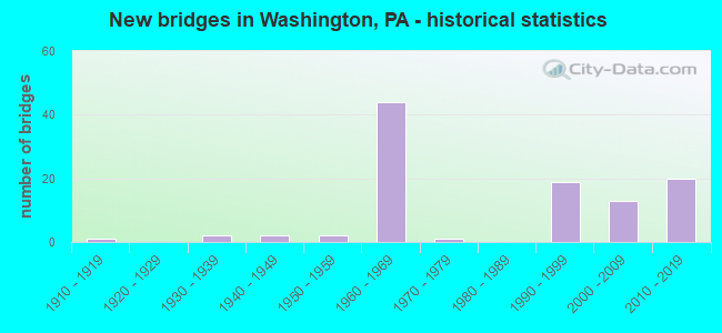
- New bridges - historical statistics
- 11910-1919
- 21930-1939
- 21940-1949
- 21950-1959
- 441960-1969
- 11970-1979
- 191990-1999
- 132000-2009
- 202010-2019

- Reconstructed bridges - Historical Statistics
- 21970-1979
- 91980-1989
- 51990-1999
- 02000-2009
- 12010-2019


- Bridge Condition - Deck
- 18.2%Very good
- 43.2%Good
- 27.3%Satisfactory
- 9.1%Fair
- 2.3%Poor

- Bridge Condition - Superstructure
- 31.9%Very good
- 23.4%Good
- 19.1%Satisfactory
- 12.8%Fair
- 10.6%Poor
- 2.1%Serious

- Bridge Condition - Substructure
- 17.0%Very good
- 31.9%Good
- 27.7%Satisfactory
- 19.1%Fair
- 4.3%Poor

- Bridge Condition - Channel
- 12.5%Very good
- 8.3%Good
- 29.2%Satisfactory
- 25.0%Fair
- 25.0%Poor

- Bridge Condition - Culverts
- 12.5%Good
- 50.0%Satisfactory
- 25.0%Fair
- 12.5%Poor
Find on map >> Show street view
Structure Number: 34314, Location: NORTH FRANKLIN TOWNSHIP (Lat: 40.145692, Lng: -80.268053), Route carried "on" structure: State highway 18, Year Built: 1934, Status: Posted for load, Structure Length: 1.65m (5.41ft), Average Daily Traffic: 5,496 (year 2020), Truck Traffic: 5%, Average Future Daily Traffic: 9,509 (year 2042), Design Load: HS 20, Features Intersected: CHARTIERS CREEK
Minimum Vertical Clearance: 30+ m (98+ ft), Kilometerpoint: 22.545, Lanes on structure: 2, Owner: State Highway Agency, Approaching Roadway Width: 7.0m (23.0ft), Material/Design: Concrete, Design/Construction: Tee Beam, Number Of Spans In Main Unit: 2, Length of Maximum Span: 7.9m (25.9ft), Curb-To-Curb Width: 7.0m (23.0ft), Out-to-Out Width: 7.6m (24.9ft)
Condition: Deck: Fair, Superstructure: Poor, Substructure: Fair, Channel: Poor, Operating Rating: 39.9 metric tons, Method Used To Determine Operating Rating: Load Factor (LF), Inventory Rating: 23.6 metric tons, Method Used To Determine Inventory Rating: Load Factor (LF), Structural Evaluation: Meets minimum limits, Deck Geometry: High priority of replacement, Waterway Adequacy: Superior to present desirable criteria, Approach Roadway Alignment: Equal to present desirable criteria, Bridge Posting: Required (Relationship of Operating Rating to Maximum Legal Load: 10.0 - 19.9% below), Length Of Structure Improvement: 2.20m (7.22ft), Designated Inspection Frequency: Every 24 months, Other Special Inspection Frequency: Every 12 months, Inspection Date: November 2019, Other Special Inspection Date: November 2020, Bridge Improvement Cost: $31,000, Roadway Improvement Cost: $92,000, Total Project Cost: $420,000, Deck Structure Type: Concrete Cast-file-Place, Wearing Surface/Protective System: Wearing Surface: Bituminous
Find on map >> Show street view
Structure Number: 34319, Location: CANTON TOWNSHIP (Lat: 40.198250, Lng: -80.269492), Route carried "on" structure: State highway 18, Year Built: 1938, Year Reconstructed: 1981, Status: Posted for load, Structure Length: 2.56m (8.40ft), Average Daily Traffic: 9,567 (year 2022), Truck Traffic: 26%, Average Future Daily Traffic: 13,832 (year 2043), Design Load: HS 20, Features Intersected: CHARTIERS CREEK
Minimum Vertical Clearance: 30+ m (98+ ft), Kilometerpoint: 29.638, Lanes on structure: 2, Owner: State Highway Agency, Approaching Roadway Width: 7.0m (23.0ft), Material/Design: Steel, Design/Construction: Girder and Floorbeam System, Number Of Spans In Main Unit: 1, Length of Maximum Span: 24.4m (80.1ft), Curb or Sidewalk Widths: Left: 0.2m (0.7ft), Right: 0.2m (0.7ft), Curb-To-Curb Width: 7.0m (23.0ft), Out-to-Out Width: 7.5m (24.6ft)
Condition: Deck: Fair, Superstructure: Fair, Substructure: Satisfactory, Channel: Fair, Operating Rating: 47.2 metric tons, Method Used To Determine Operating Rating: Load Factor (LF), Inventory Rating: 28.1 metric tons, Method Used To Determine Inventory Rating: Load Factor (LF), Structural Evaluation: Somewhat better than minimum adequacy, Deck Geometry: High priority of replacement, Waterway Adequacy: Equal to present minimum criteria, Approach Roadway Alignment: Equal to present desirable criteria, Length Of Structure Improvement: 3.20m (10.50ft), Designated Inspection Frequency: Every 24 months, Critical Feature Inspection Frequency: Every 24 months, Other Special Inspection Frequency: Every 12 months, Inspection Date: November 2021, Critical Feature Inspection Date: November 2021, Other Special Inspection Date: November 2021, Bridge Improvement Cost: $28,000, Roadway Improvement Cost: $82,000, Total Project Cost: $376,000, Deck Structure Type: Concrete Cast-file-Place, Wearing Surface/Protective System: Wearing Surface: Monolithic Concrete, Deck Protection: Epoxy Coated Reinforcing
Find on map >> Show street view
Structure Number: 34336, Location: AMWELL TOWNSHIP (Lat: 40.107453, Lng: -80.203944), Route carried "on" structure: US 19, Year Built: 1965, Year Reconstructed: 2001, Status: Open, Structure Length: 1.01m (3.31ft), Average Daily Traffic: 3,525 (year 2020), Truck Traffic: 4%, Average Future Daily Traffic: 2,739 (year 2032), Design Load: HS 20+Mod, Features Intersected: LITTLE TENMILE CREEK
Minimum Vertical Clearance: 30+ m (98+ ft), Kilometerpoint: 12.962, Lanes on structure: 2, Owner: State Highway Agency, Approaching Roadway Width: 13.4m (44.0ft), Skew: 1 degrees, Material/Design: Prestressed concrete, Design/Construction: Box Beam or Girders - Multiple, Number Of Spans In Main Unit: 1, Length of Maximum Span: 9.1m (29.9ft), Curb or Sidewalk Widths: Left: 0.5m (1.6ft), Right: 0.5m (1.6ft), Curb-To-Curb Width: 12.8m (42.0ft), Out-to-Out Width: 13.9m (45.6ft)
Condition: Deck: Good, Superstructure: Fair, Substructure: Fair, Channel: Fair, Operating Rating: 89.8 metric tons, Method Used To Determine Operating Rating: Load Factor (LF), Inventory Rating: 56.2 metric tons, Method Used To Determine Inventory Rating: Load Factor (LF), Structural Evaluation: Somewhat better than minimum adequacy, Deck Geometry: Equal to present minimum criteria, Waterway Adequacy: Better than present minimum criteria, Approach Roadway Alignment: Equal to present desirable criteria, Length Of Structure Improvement: 1.00m (3.28ft), Designated Inspection Frequency: Every 24 months, Inspection Date: November 2021, Bridge Improvement Cost: $18,000, Roadway Improvement Cost: $100,000, Total Project Cost: $237,000, Deck Structure Type: Concrete Cast-file-Place, Wearing Surface/Protective System: Wearing Surface: Monolithic Concrete
Find on map >> Show street view
Structure Number: 34337, Location: AMWELL TOWNSHIP (Lat: 40.108328, Lng: -80.201886), Route carried "on" structure: US 19, Year Built: 1965, Status: Open, Structure Length: 0.76m (2.49ft), Average Daily Traffic: 3,039 (year 2020), Truck Traffic: 4%, Average Future Daily Traffic: 3,155 (year 2032), Design Load: HS 20, Features Intersected: BR. LITTLE TENMILE CREEK
Minimum Vertical Clearance: 30+ m (98+ ft), Kilometerpoint: 13.304, Lanes on structure: 2, Owner: State Highway Agency, Approaching Roadway Width: 13.4m (44.0ft), Skew: 1 degrees, Material/Design: Concrete, Design/Construction: Culvert, Number Of Spans In Main Unit: 1, Length of Maximum Span: 6.7m (22.0ft)
Condition: Channel: Poor, Culverts: Satisfactory, Inventory Rating: 99.8 metric tons, Method Used To Determine Inventory Rating: Load Factor (LF), Structural Evaluation: Equal to present minimum criteria, Waterway Adequacy: Superior to present desirable criteria, Approach Roadway Alignment: Equal to present desirable criteria, Length Of Structure Improvement: 1.30m (4.27ft), Designated Inspection Frequency: Every 48 months, Inspection Date: November 2019, Bridge Improvement Cost: $12,000, Roadway Improvement Cost: $35,000, Total Project Cost: $160,000
Find on map >> Show street view
Structure Number: 34387, Location: CITY OF WASHINGTON (Lat: 40.171222, Lng: -80.255136), Route carried "on" structure: US 40, Year Built: 1943, Year Reconstructed: 1979, Status: Open, Structure Length: 0.88m (2.89ft), Average Daily Traffic: 11,898 (year 2020), Truck Traffic: 2%, Average Future Daily Traffic: 15,430 (year 2032), Features Intersected: CATFISH RUN
Minimum Vertical Clearance: 30+ m (98+ ft), Kilometerpoint: 25.721, Lanes on structure: 2, Base Highway Network: Yes, Owner: State Highway Agency, Approaching Roadway Width: 10.7m (35.1ft), Material/Design: Concrete, Design/Construction: Tee Beam, Number Of Spans In Main Unit: 1, Length of Maximum Span: 7.9m (25.9ft), Curb or Sidewalk Widths: Left: 5.4m (17.7ft), Right: 2.7m (8.9ft), Curb-To-Curb Width: 10.5m (34.4ft), Out-to-Out Width: 18.7m (61.4ft)
Condition: Deck: Satisfactory, Superstructure: Fair, Substructure: Poor, Channel: Satisfactory, Operating Rating: 76.2 metric tons, Method Used To Determine Operating Rating: Field evaluation and documented engineering judgment, Inventory Rating: 45.4 metric tons, Method Used To Determine Inventory Rating: Field evaluation and documented engineering judgment, Structural Evaluation: Meets minimum limits, Deck Geometry: Meets minimum limits, Waterway Adequacy: Superior to present desirable criteria, Approach Roadway Alignment: Equal to present desirable criteria, Length Of Structure Improvement: 1.60m (5.25ft), Designated Inspection Frequency: Every 24 months, Inspection Date: November 2019, Deck Structure Type: Concrete Cast-file-Place, Wearing Surface/Protective System: Wearing Surface: Bituminous
Find on map >> Show street view
Structure Number: 34458, Location: NORTH FRANKLIN TOWNSHIP (Lat: 40.153478, Lng: -80.287347), Route carried "on" structure: State highway , Year Built: 1960, Year Reconstructed: 2019, Status: Open, Structure Length: 4.02m (13.19ft), Average Daily Traffic: 560 (year 2021), Truck Traffic: 6%, Average Future Daily Traffic: 726 (year 2032), Design Load: HL 93, Features Intersected: SR 0070, Facility Carried by Structure: TOWNSHIP ROAD 505
Minimum Vertical Clearance: 30+ m (98+ ft), Kilometerpoint: 0.000, Lanes on structure: 2, Lanes under structure: 8, Owner: State Highway Agency, Approaching Roadway Width: 8.5m (27.9ft), Material/Design: Prestressed concrete continuous, Design/Construction: Box Beam or Girders - Single/Spread, Number Of Spans In Main Unit: 2, Length of Maximum Span: 19.5m (64.0ft), Curb-To-Curb Width: 8.7m (28.5ft), Out-to-Out Width: 9.3m (30.5ft)
Condition: Deck: Very good, Superstructure: Very good, Substructure: Good, Operating Rating: 42.4 metric tons, Method Used To Determine Operating Rating: Assigned ratings based on Load and Resistance Factor Design (LRFD) reported by rating factor (RF) using HL93 loadings, Inventory Rating: 32.7 metric tons, Method Used To Determine Inventory Rating: Assigned ratings based on Load and Resistance Factor Design (LRFD) reported by rating factor (RF) using HL93 loadings, Structural Evaluation: Better than present minimum criteria, Deck Geometry: Somewhat better than minimum adequacy, Underclear: Superior to present desirable criteria, Approach Roadway Alignment: Equal to present desirable criteria, Length Of Structure Improvement: 4.10m (13.45ft), Designated Inspection Frequency: Every 24 months, Inspection Date: August 2021, Bridge Improvement Cost: $32,000, Roadway Improvement Cost: $200,000, Total Project Cost: $434,000, Deck Structure Type: Concrete Cast-file-Place, Wearing Surface/Protective System: Wearing Surface: Monolithic Concrete, Deck Protection: Epoxy Coated Reinforcing
Find on map >> Show street view
Structure Number: 34461, Location: NORTH FRANKLIN TOWNSHIP (Lat: 40.162144, Lng: -80.277914), Route carried "on" structure: Interstate 70, Year Built: 1960, Year Reconstructed: 1993, Status: Open, Structure Length: 6.83m (22.41ft), Average Daily Traffic: 25,197 (year 2021), Truck Traffic: 22%, Average Future Daily Traffic: 16,685 (year 2032), Design Load: HS 25 or greater, Features Intersected: SR 0040
Minimum Vertical Clearance: 30+ m (98+ ft), Kilometerpoint: 23.389, Lanes on structure: 2, Lanes under structure: 4, Base Highway Network: Yes, Owner: State Highway Agency, Approaching Roadway Width: 10.4m (34.1ft), Skew: 14 degrees, Material/Design: Steel continuous, Design/Construction: Stringer/Multi-beam, Number Of Spans In Main Unit: 1, Number Of Approach Spans: 2, Length of Maximum Span: 34.7m (113.8ft), Curb or Sidewalk Widths: Left: 0.2m (0.7ft), Right: 0.2m (0.7ft), Curb-To-Curb Width: 10.4m (34.1ft), Out-to-Out Width: 11.4m (37.4ft)
Condition: Deck: Satisfactory, Superstructure: Fair, Substructure: Good, Operating Rating: 80.7 metric tons, Method Used To Determine Operating Rating: Load Factor (LF), Inventory Rating: 48.1 metric tons, Method Used To Determine Inventory Rating: Load Factor (LF), Structural Evaluation: Somewhat better than minimum adequacy, Deck Geometry: Meets minimum limits, Underclear: Equal to present minimum criteria, Approach Roadway Alignment: Equal to present desirable criteria, Length Of Structure Improvement: 6.90m (22.64ft), Designated Inspection Frequency: Every 24 months, Inspection Date: August 2021, Bridge Improvement Cost: $32,000, Roadway Improvement Cost: $200,000, Total Project Cost: $434,000, Deck Structure Type: Concrete Cast-file-Place, Wearing Surface/Protective System: Wearing Surface: Monolithic Concrete, Membrane: Built-up, Deck Protection: Epoxy Coated Reinforcing
Find on map >> Show street view
Structure Number: 34463, Location: NORTH FRANKLIN TOWNSHIP (Lat: 40.162036, Lng: -80.278272), Route carried "on" structure: Interstate 70, Year Built: 1960, Year Reconstructed: 1993, Status: Open, Structure Length: 6.98m (22.90ft), Average Daily Traffic: 24,481 (year 2021), Truck Traffic: 23%, Average Future Daily Traffic: 16,320 (year 2032), Design Load: HS 25 or greater, Features Intersected: SR 0040
Minimum Vertical Clearance: 30+ m (98+ ft), Kilometerpoint: 23.360, Lanes on structure: 3, Lanes under structure: 4, Base Highway Network: Yes, Owner: State Highway Agency, Approaching Roadway Width: 14.0m (45.9ft), Skew: 14 degrees, Material/Design: Steel continuous, Design/Construction: Stringer/Multi-beam, Number Of Spans In Main Unit: 1, Number Of Approach Spans: 2, Length of Maximum Span: 36.0m (118.1ft), Curb or Sidewalk Widths: Left: 0.2m (0.7ft), Right: 0.2m (0.7ft), Curb-To-Curb Width: 14.0m (45.9ft), Out-to-Out Width: 15.1m (49.5ft)
Condition: Deck: Satisfactory, Superstructure: Fair, Substructure: Satisfactory, Operating Rating: 82.6 metric tons, Method Used To Determine Operating Rating: Load Factor (LF), Inventory Rating: 49.9 metric tons, Method Used To Determine Inventory Rating: Load Factor (LF), Structural Evaluation: Somewhat better than minimum adequacy, Deck Geometry: Meets minimum limits, Underclear: Equal to present minimum criteria, Approach Roadway Alignment: Equal to present desirable criteria, Length Of Structure Improvement: 6.90m (22.64ft), Designated Inspection Frequency: Every 24 months, Inspection Date: August 2021, Bridge Improvement Cost: $60,000, Roadway Improvement Cost: $200,000, Total Project Cost: $805,000, Deck Structure Type: Concrete Cast-file-Place, Wearing Surface/Protective System: Wearing Surface: Monolithic Concrete, Deck Protection: Epoxy Coated Reinforcing
Find on map >> Show street view
Structure Number: 34465, Location: CANTON TOWNSHIP (Lat: 40.168069, Lng: -80.275144), Route carried "on" structure: Interstate 70, Year Built: 1960, Status: Open, Structure Length: 1.71m (5.61ft), Average Daily Traffic: 49,678 (year 2021), Truck Traffic: 23%, Average Future Daily Traffic: 33,005 (year 2032), Design Load: HS 20+Mod, Features Intersected: CHARTIERS CREEK
Minimum Vertical Clearance: 30+ m (98+ ft), Kilometerpoint: 24.211, Lanes on structure: 4, Base Highway Network: Yes, Owner: State Highway Agency, Approaching Roadway Width: 23.8m (78.1ft), Skew: 23 degrees, Material/Design: Concrete, Design/Construction: Culvert, Number Of Spans In Main Unit: 1, Length of Maximum Span: 17.1m (56.1ft)
Condition: Channel: Fair, Culverts: Fair, Operating Rating: 89.8 metric tons, Method Used To Determine Operating Rating: Load Factor (LF), Inventory Rating: 71.7 metric tons, Method Used To Determine Inventory Rating: Load Factor (LF), Structural Evaluation: Somewhat better than minimum adequacy, Waterway Adequacy: Superior to present desirable criteria, Approach Roadway Alignment: Equal to present desirable criteria, Length Of Structure Improvement: 1.70m (5.58ft), Designated Inspection Frequency: Every 24 months, Inspection Date: August 2021, Bridge Improvement Cost: $76,000, Roadway Improvement Cost: $222,000, Total Project Cost: $1,020,000
Find on map >> Show street view
Structure Number: 34467, Location: CANTON TOWNSHIP (Lat: 40.170822, Lng: -80.273053), Route carried "on" structure: Interstate 70, Year Built: 1960, Year Reconstructed: 1993, Status: Open, Structure Length: 17.34m (56.89ft), Average Daily Traffic: 25,197 (year 2021), Truck Traffic: 22%, Average Future Daily Traffic: 16,685 (year 2032), Design Load: HS 25 or greater, Features Intersected: SR 4051 & Alghy Val R/R
Minimum Vertical Clearance: 30+ m (98+ ft), Kilometerpoint: 24.995, Lanes on structure: 2, Lanes under structure: 2, Base Highway Network: Yes, Owner: State Highway Agency, Approaching Roadway Width: 11.3m (37.1ft), Skew: 10 degrees, Material/Design: Steel continuous, Design/Construction: Girder and Floorbeam System, Number Of Spans In Main Unit: 6, Length of Maximum Span: 43.3m (142.1ft), Curb or Sidewalk Widths: Left: 0.2m (0.7ft), Right: 0.2m (0.7ft), Curb-To-Curb Width: 10.4m (34.1ft), Out-to-Out Width: 11.4m (37.4ft)
Condition: Deck: Good, Superstructure: Satisfactory, Substructure: Satisfactory, Operating Rating: 81.6 metric tons, Method Used To Determine Operating Rating: Load Factor (LF), Inventory Rating: 49.0 metric tons, Method Used To Determine Inventory Rating: Load Factor (LF), Structural Evaluation: Equal to present minimum criteria, Deck Geometry: Meets minimum limits, Underclear: Superior to present desirable criteria, Approach Roadway Alignment: Equal to present desirable criteria, Length Of Structure Improvement: 17.40m (57.09ft), Designated Inspection Frequency: Every 24 months, Critical Feature Inspection Frequency: Every 24 months, Inspection Date: August 2021, Critical Feature Inspection Date: August 2021, Bridge Improvement Cost: $222,000, Roadway Improvement Cost: $653,000, Total Project Cost: $2,994,000, Deck Structure Type: Concrete Cast-file-Place, Wearing Surface/Protective System: Wearing Surface: Monolithic Concrete, Deck Protection: Epoxy Coated Reinforcing
Find on map >> Show street view
Structure Number: 3447, Location: CANTON TOWNSHIP (Lat: 40.170861, Lng: -80.273278), Route carried "on" structure: Interstate 70, Year Built: 1960, Year Reconstructed: 1993, Status: Open, Structure Length: 13.14m (43.11ft), Average Daily Traffic: 24,481 (year 2021), Truck Traffic: 23%, Average Future Daily Traffic: 16,320 (year 2032), Design Load: HS 25 or greater, Features Intersected: SR 4051 & Alghy Val R/R
Minimum Vertical Clearance: 30+ m (98+ ft), Kilometerpoint: 24.992, Lanes on structure: 2, Lanes under structure: 2, Base Highway Network: Yes, Owner: State Highway Agency, Approaching Roadway Width: 10.4m (34.1ft), Skew: 10 degrees, Material/Design: Steel continuous, Design/Construction: Girder and Floorbeam System, Number Of Spans In Main Unit: 4, Length of Maximum Span: 41.8m (137.1ft), Curb or Sidewalk Widths: Left: 0.2m (0.7ft), Right: 0.2m (0.7ft), Curb-To-Curb Width: 10.4m (34.1ft), Out-to-Out Width: 11.4m (37.4ft)
Condition: Deck: Satisfactory, Superstructure: Satisfactory, Substructure: Satisfactory, Operating Rating: 78.0 metric tons, Method Used To Determine Operating Rating: Load Factor (LF), Inventory Rating: 46.3 metric tons, Method Used To Determine Inventory Rating: Load Factor (LF), Structural Evaluation: Equal to present minimum criteria, Deck Geometry: Meets minimum limits, Underclear: Superior to present desirable criteria, Approach Roadway Alignment: Equal to present desirable criteria, Length Of Structure Improvement: 13.30m (43.64ft), Designated Inspection Frequency: Every 24 months, Critical Feature Inspection Frequency: Every 24 months, Inspection Date: August 2021, Critical Feature Inspection Date: August 2021, Bridge Improvement Cost: $170,000, Roadway Improvement Cost: $499,000, Total Project Cost: $2,289,000, Deck Structure Type: Concrete Cast-file-Place, Wearing Surface/Protective System: Wearing Surface: Monolithic Concrete, Deck Protection: Epoxy Coated Reinforcing
Find on map >> Show street view
Structure Number: 34471, Location: CANTON TOWNSHIP (Lat: 40.178164, Lng: -80.266872), Route carried "on" structure: Interstate 70, Year Built: 1960, Status: Open, Structure Length: 0.88m (2.89ft), Average Daily Traffic: 37,115 (year 2021), Truck Traffic: 31%, Average Future Daily Traffic: 33,005 (year 2032), Design Load: HS 20+Mod, Features Intersected: CATFISH CREEK
Minimum Vertical Clearance: 30+ m (98+ ft), Kilometerpoint: 25.803, Lanes on structure: 4, Base Highway Network: Yes, Owner: State Highway Agency, Approaching Roadway Width: 23.8m (78.1ft), Material/Design: Concrete, Design/Construction: Culvert, Number Of Spans In Main Unit: 1, Length of Maximum Span: 8.8m (28.9ft)
Condition: Channel: Satisfactory, Culverts: Satisfactory, Operating Rating: 89.8 metric tons, Method Used To Determine Operating Rating: Allowable Stress (AS), Inventory Rating: 89.8 metric tons, Method Used To Determine Inventory Rating: Allowable Stress (AS), Structural Evaluation: Equal to present minimum criteria, Waterway Adequacy: Superior to present desirable criteria, Approach Roadway Alignment: Equal to present desirable criteria, Length Of Structure Improvement: 0.90m (2.95ft), Designated Inspection Frequency: Every 48 months, Inspection Date: August 2021, Bridge Improvement Cost: $39,000, Roadway Improvement Cost: $150,000, Total Project Cost: $523,000
Find on map >> Show street view
Structure Number: 34472, Location: CANTON TOWNSHIP (Lat: 40.179742, Lng: -80.265539), Route carried "on" structure: Interstate 70, Year Built: 1960, Year Reconstructed: 1993, Status: Open, Structure Length: 4.91m (16.11ft), Average Daily Traffic: 22,273 (year 2021), Truck Traffic: 30%, Average Future Daily Traffic: 16,685 (year 2032), Design Load: HS 25 or greater, Features Intersected: TWP RD 957 (OHIO AVE)
Minimum Vertical Clearance: 30+ m (98+ ft), Kilometerpoint: 25.803, Lanes on structure: 2, Lanes under structure: 2, Base Highway Network: Yes, Owner: State Highway Agency, Approaching Roadway Width: 12.8m (42.0ft), Skew: 11 degrees, Material/Design: Prestressed concrete, Design/Construction: Box Beam or Girders - Single/Spread, Number Of Spans In Main Unit: 3, Length of Maximum Span: 16.5m (54.1ft), Curb or Sidewalk Widths: Left: 0.2m (0.7ft), Right: 0.2m (0.7ft), Curb-To-Curb Width: 12.8m (42.0ft), Out-to-Out Width: 13.9m (45.6ft)
Condition: Deck: Good, Superstructure: Satisfactory, Substructure: Satisfactory, Operating Rating: 89.8 metric tons, Method Used To Determine Operating Rating: Load Factor (LF), Inventory Rating: 67.1 metric tons, Method Used To Determine Inventory Rating: Load Factor (LF), Structural Evaluation: Equal to present minimum criteria, Deck Geometry: Equal to present desirable criteria, Underclear: Superior to present desirable criteria, Approach Roadway Alignment: Equal to present desirable criteria, Length Of Structure Improvement: 5.00m (16.40ft), Designated Inspection Frequency: Every 24 months, Inspection Date: August 2021, Bridge Improvement Cost: $68,000, Roadway Improvement Cost: $200,000, Total Project Cost: $912,000, Deck Structure Type: Concrete Cast-file-Place, Wearing Surface/Protective System: Wearing Surface: Monolithic Concrete, Membrane: Built-up, Deck Protection: Epoxy Coated Reinforcing
Find on map >> Show street view
Structure Number: 34473, Location: CANTON TOWNSHIP (Lat: 40.179875, Lng: -80.265725), Route carried "on" structure: Interstate 70, Year Built: 1960, Year Reconstructed: 1993, Status: Open, Structure Length: 4.91m (16.11ft), Average Daily Traffic: 14,842 (year 2021), Truck Traffic: 32%, Average Future Daily Traffic: 16,320 (year 2032), Design Load: HS 25 or greater, Features Intersected: TWP RD 957 (OHIO AVE)
Minimum Vertical Clearance: 30+ m (98+ ft), Kilometerpoint: 25.766, Lanes on structure: 2, Lanes under structure: 2, Base Highway Network: Yes, Owner: State Highway Agency, Approaching Roadway Width: 12.8m (42.0ft), Skew: 11 degrees, Material/Design: Prestressed concrete, Design/Construction: Box Beam or Girders - Single/Spread, Number Of Spans In Main Unit: 3, Length of Maximum Span: 16.5m (54.1ft), Curb or Sidewalk Widths: Left: 0.2m (0.7ft), Right: 0.2m (0.7ft), Curb-To-Curb Width: 12.8m (42.0ft), Out-to-Out Width: 13.9m (45.6ft)
Condition: Deck: Good, Superstructure: Satisfactory, Substructure: Satisfactory, Inventory Rating: 59.0 metric tons, Method Used To Determine Inventory Rating: Load Factor (LF), Structural Evaluation: Equal to present minimum criteria, Deck Geometry: Equal to present desirable criteria, Underclear: Superior to present desirable criteria, Approach Roadway Alignment: Equal to present desirable criteria, Length Of Structure Improvement: 5.00m (16.40ft), Designated Inspection Frequency: Every 24 months, Inspection Date: August 2021, Bridge Improvement Cost: $77,000, Roadway Improvement Cost: $227,000, Total Project Cost: $1,041,000, Deck Structure Type: Concrete Cast-file-Place, Wearing Surface/Protective System: Wearing Surface: Monolithic Concrete, Deck Protection: Epoxy Coated Reinforcing
Find on map >> Show street view
Structure Number: 34474, Location: CITY OF WASHINGTON (Lat: 40.181522, Lng: -80.263511), Route carried "on" structure: Interstate 70, Year Built: 1993, Status: Open, Structure Length: 21.34m (70.01ft), Average Daily Traffic: 22,273 (year 2021), Truck Traffic: 30%, Average Future Daily Traffic: 16,685 (year 2032), Design Load: HS 25 or greater, Features Intersected: SR 0018 & CITY STREETS
Minimum Vertical Clearance: 30+ m (98+ ft), Kilometerpoint: 26.475, Lanes on structure: 2, Lanes under structure: 28, Base Highway Network: Yes, Owner: State Highway Agency, Approaching Roadway Width: 10.4m (34.1ft), Skew: 10 degrees, Material/Design: Prestressed concrete continuous, Design/Construction: Stringer/Multi-beam, Number Of Spans In Main Unit: 7, Number Of Approach Spans: 1, Length of Maximum Span: 28.7m (94.2ft), Curb or Sidewalk Widths: Left: 0.2m (0.7ft), Right: 0.2m (0.7ft), Curb-To-Curb Width: 10.4m (34.1ft), Out-to-Out Width: 11.4m (37.4ft)
Condition: Deck: Satisfactory, Superstructure: Good, Substructure: Good, Inventory Rating: 40.8 metric tons, Method Used To Determine Inventory Rating: Load Factor (LF), Structural Evaluation: Better than present minimum criteria, Deck Geometry: Meets minimum limits, Underclear: High priority of corrective action, Approach Roadway Alignment: Equal to present desirable criteria, Length Of Structure Improvement: 26.40m (86.61ft), Designated Inspection Frequency: Every 24 months, Inspection Date: August 2021, Bridge Improvement Cost: $302,000, Roadway Improvement Cost: $891,000, Total Project Cost: $4,082,000, Deck Structure Type: Concrete Cast-file-Place, Wearing Surface/Protective System: Wearing Surface: Monolithic Concrete, Membrane: Built-up, Deck Protection: Epoxy Coated Reinforcing
Find on map >> Show street view
Structure Number: 34475, Location: CITY OF WASHINGTON (Lat: 40.183767, Lng: -80.258517), Route carried "on" structure: Interstate 70, Year Built: 1960, Year Reconstructed: 1993, Status: Open, Structure Length: 4.45m (14.60ft), Average Daily Traffic: 23,164 (year 2021), Truck Traffic: 28%, Average Future Daily Traffic: 23,477 (year 2032), Design Load: HS 25 or greater, Features Intersected: DONNAN AVENUE
Minimum Vertical Clearance: 30+ m (98+ ft), Kilometerpoint: 26.475, Lanes on structure: 3, Lanes under structure: 2, Base Highway Network: Yes, Owner: State Highway Agency, Approaching Roadway Width: 14.6m (47.9ft), Skew: 12 degrees, Material/Design: Prestressed concrete, Design/Construction: Box Beam or Girders - Single/Spread, Number Of Spans In Main Unit: 3, Length of Maximum Span: 17.1m (56.1ft), Curb or Sidewalk Widths: Left: 0.2m (0.7ft), Right: 0.2m (0.7ft), Curb-To-Curb Width: 14.6m (47.9ft), Out-to-Out Width: 15.7m (51.5ft)
Condition: Deck: Satisfactory, Superstructure: Good, Substructure: Satisfactory, Operating Rating: 77.1 metric tons, Method Used To Determine Operating Rating: Load Factor (LF), Inventory Rating: 45.4 metric tons, Method Used To Determine Inventory Rating: Load Factor (LF), Structural Evaluation: Equal to present minimum criteria, Deck Geometry: Meets minimum limits, Underclear: Equal to present minimum criteria, Approach Roadway Alignment: Equal to present desirable criteria, Length Of Structure Improvement: 4.30m (14.11ft), Designated Inspection Frequency: Every 24 months, Inspection Date: August 2021, Bridge Improvement Cost: $113,000, Roadway Improvement Cost: $333,000, Total Project Cost: $1,526,000, Deck Structure Type: Concrete Cast-file-Place, Wearing Surface/Protective System: Wearing Surface: Monolithic Concrete, Membrane: Built-up, Deck Protection: Epoxy Coated Reinforcing
Find on map >> Show street view
Structure Number: 34477, Location: CITY OF WASHINGTON (Lat: 40.181675, Lng: -80.263697), Route carried "on" structure: Interstate 70, Year Built: 1993, Status: Open, Structure Length: 21.34m (70.01ft), Average Daily Traffic: 14,842 (year 2021), Truck Traffic: 32%, Average Future Daily Traffic: 16,320 (year 2032), Design Load: HS 25 or greater, Features Intersected: SR 0018 & CITY STREETS
Minimum Vertical Clearance: 30+ m (98+ ft), Kilometerpoint: 26.445, Lanes on structure: 3, Lanes under structure: 7, Base Highway Network: Yes, Owner: State Highway Agency, Approaching Roadway Width: 13.7m (44.9ft), Skew: 10 degrees, Material/Design: Prestressed concrete continuous, Design/Construction: Stringer/Multi-beam, Number Of Spans In Main Unit: 7, Number Of Approach Spans: 1, Length of Maximum Span: 28.7m (94.2ft), Curb or Sidewalk Widths: Left: 0.2m (0.7ft), Right: 0.2m (0.7ft), Curb-To-Curb Width: 13.9m (45.6ft), Out-to-Out Width: 14.9m (48.9ft)
Condition: Deck: Good, Superstructure: Satisfactory, Substructure: Good, Inventory Rating: 45.4 metric tons, Method Used To Determine Inventory Rating: Load Factor (LF), Structural Evaluation: Equal to present minimum criteria, Deck Geometry: Meets minimum limits, Underclear: High priority of corrective action, Approach Roadway Alignment: Equal to present desirable criteria, Length Of Structure Improvement: 26.40m (86.61ft), Designated Inspection Frequency: Every 24 months, Inspection Date: August 2021, Bridge Improvement Cost: $321,000, Roadway Improvement Cost: $945,000, Total Project Cost: $4,331,000, Deck Structure Type: Concrete Cast-file-Place, Wearing Surface/Protective System: Wearing Surface: Monolithic Concrete, Deck Protection: Epoxy Coated Reinforcing
Find on map >> Show street view
Structure Number: 34478, Location: CITY OF WASHINGTON (Lat: 40.184014, Lng: -80.258439), Route carried "on" structure: Interstate 70, Year Built: 1960, Year Reconstructed: 1993, Status: Open, Structure Length: 4.45m (14.60ft), Average Daily Traffic: 34,575 (year 2021), Truck Traffic: 35%, Average Future Daily Traffic: 22,701 (year 2032), Design Load: HS 25 or greater, Features Intersected: DONNAN AVENUE
Minimum Vertical Clearance: 30+ m (98+ ft), Kilometerpoint: 26.445, Lanes on structure: 2, Lanes under structure: 2, Base Highway Network: Yes, Owner: State Highway Agency, Approaching Roadway Width: 12.8m (42.0ft), Skew: 12 degrees, Material/Design: Prestressed concrete, Design/Construction: Box Beam or Girders - Single/Spread, Number Of Spans In Main Unit: 3, Length of Maximum Span: 17.1m (56.1ft), Curb or Sidewalk Widths: Left: 0.2m (0.7ft), Right: 0.2m (0.7ft), Curb-To-Curb Width: 12.8m (42.0ft), Out-to-Out Width: 13.9m (45.6ft)
Condition: Deck: Satisfactory, Superstructure: Satisfactory, Substructure: Satisfactory, Inventory Rating: 86.2 metric tons, Method Used To Determine Inventory Rating: Load Factor (LF), Structural Evaluation: Equal to present minimum criteria, Deck Geometry: Equal to present desirable criteria, Underclear: Superior to present desirable criteria, Approach Roadway Alignment: Equal to present desirable criteria, Length Of Structure Improvement: 4.30m (14.11ft), Designated Inspection Frequency: Every 24 months, Inspection Date: August 2021, Bridge Improvement Cost: $72,000, Roadway Improvement Cost: $211,000, Total Project Cost: $969,000, Deck Structure Type: Concrete Cast-file-Place, Wearing Surface/Protective System: Wearing Surface: Monolithic Concrete, Membrane: Built-up, Deck Protection: Epoxy Coated Reinforcing
Find on map >> Show street view
Structure Number: 3448, Location: SOUTH STRABANE TOWNSHIP (Lat: 40.188497, Lng: -80.246519), Route carried "on" structure: Interstate 70, Year Built: 1960, Year Reconstructed: 1996, Status: Open, Structure Length: 2.23m (7.32ft), Average Daily Traffic: 20,750 (year 2021), Truck Traffic: 27%, Average Future Daily Traffic: 36,310 (year 2032), Design Load: HS 20+Mod, Features Intersected: SR 8016
Minimum Vertical Clearance: 30+ m (98+ ft), Kilometerpoint: 28.238, Lanes on structure: 2, Lanes under structure: 1, Base Highway Network: Yes, Owner: State Highway Agency, Approaching Roadway Width: 12.8m (42.0ft), Skew: 14 degrees, Material/Design: Steel, Design/Construction: Stringer/Multi-beam, Number Of Spans In Main Unit: 1, Length of Maximum Span: 20.7m (67.9ft), Curb-To-Curb Width: 12.8m (42.0ft), Out-to-Out Width: 13.9m (45.6ft)
Condition: Deck: Good, Superstructure: Good, Substructure: Fair, Operating Rating: 83.5 metric tons, Method Used To Determine Operating Rating: Load Factor (LF), Inventory Rating: 49.9 metric tons, Method Used To Determine Inventory Rating: Load Factor (LF), Structural Evaluation: Somewhat better than minimum adequacy, Deck Geometry: Equal to present desirable criteria, Underclear: Somewhat better than minimum adequacy, Approach Roadway Alignment: Equal to present desirable criteria, Length Of Structure Improvement: 4.80m (15.75ft), Designated Inspection Frequency: Every 24 months, Inspection Date: July 2021, Bridge Improvement Cost: $46,000, Roadway Improvement Cost: $200,000, Total Project Cost: $623,000, Deck Structure Type: Concrete Cast-file-Place, Wearing Surface/Protective System: Wearing Surface: Monolithic Concrete, Deck Protection: Epoxy Coated Reinforcing
Find on map >> Show street view
Structure Number: 34482, Location: SOUTH STRABANE TOWNSHIP (Lat: 40.187922, Lng: -80.241400), Route carried "on" structure: Interstate 70, Year Built: 1960, Year Reconstructed: 1995, Status: Open, Structure Length: 4.85m (15.91ft), Average Daily Traffic: 20,750 (year 2021), Truck Traffic: 27%, Average Future Daily Traffic: 36,310 (year 2032), Design Load: HS 20+Mod, Features Intersected: SR 1009
Minimum Vertical Clearance: 30+ m (98+ ft), Kilometerpoint: 28.238, Lanes on structure: 3, Lanes under structure: 2, Base Highway Network: Yes, Owner: State Highway Agency, Approaching Roadway Width: 18.3m (60.0ft), Skew: 10 degrees, Material/Design: Prestressed concrete continuous, Design/Construction: Stringer/Multi-beam, Number Of Spans In Main Unit: 3, Length of Maximum Span: 16.2m (53.1ft), Curb or Sidewalk Widths: Left: 0.2m (0.7ft), Right: 0.2m (0.7ft), Curb-To-Curb Width: 18.3m (60.0ft), Out-to-Out Width: 19.4m (63.6ft)
Condition: Deck: Satisfactory, Superstructure: Satisfactory, Substructure: Satisfactory, Operating Rating: 88.0 metric tons, Method Used To Determine Operating Rating: Load Factor (LF), Inventory Rating: 34.5 metric tons, Method Used To Determine Inventory Rating: Load Factor (LF), Structural Evaluation: Equal to present minimum criteria, Deck Geometry: Better than present minimum criteria, Underclear: Superior to present desirable criteria, Approach Roadway Alignment: Equal to present desirable criteria, Length Of Structure Improvement: 5.00m (16.40ft), Designated Inspection Frequency: Every 24 months, Inspection Date: August 2021, Bridge Improvement Cost: $44,000, Roadway Improvement Cost: $200,000, Total Project Cost: $595,000, Deck Structure Type: Concrete Cast-file-Place, Wearing Surface/Protective System: Wearing Surface: Monolithic Concrete, Deck Protection: Epoxy Coated Reinforcing
Find on map >> Show street view
Structure Number: 34483, Location: SOUTH STRABANE TOWNSHIP (Lat: 40.188719, Lng: -80.246233), Route carried "on" structure: Interstate 70, Year Built: 1960, Year Reconstructed: 1996, Status: Open, Structure Length: 4.85m (15.91ft), Average Daily Traffic: 21,121 (year 2021), Truck Traffic: 27%, Average Future Daily Traffic: 37,510 (year 2032), Design Load: HS 20+Mod, Features Intersected: SR 8016
Minimum Vertical Clearance: 30+ m (98+ ft), Kilometerpoint: 28.186, Lanes on structure: 2, Lanes under structure: 1, Base Highway Network: Yes, Owner: State Highway Agency, Approaching Roadway Width: 12.8m (42.0ft), Skew: 14 degrees, Material/Design: Steel continuous, Design/Construction: Stringer/Multi-beam, Number Of Spans In Main Unit: 3, Length of Maximum Span: 20.1m (65.9ft), Curb-To-Curb Width: 12.8m (42.0ft), Out-to-Out Width: 13.9m (45.6ft)
Condition: Deck: Good, Superstructure: Good, Substructure: Good, Operating Rating: 84.4 metric tons, Method Used To Determine Operating Rating: Load Factor (LF), Inventory Rating: 50.8 metric tons, Method Used To Determine Inventory Rating: Load Factor (LF), Structural Evaluation: Better than present minimum criteria, Deck Geometry: Equal to present desirable criteria, Underclear: Somewhat better than minimum adequacy, Approach Roadway Alignment: Equal to present desirable criteria, Length Of Structure Improvement: 2.10m (6.89ft), Designated Inspection Frequency: Every 24 months, Inspection Date: July 2021, Bridge Improvement Cost: $78,000, Roadway Improvement Cost: $229,000, Total Project Cost: $1,051,000, Deck Structure Type: Concrete Cast-file-Place, Wearing Surface/Protective System: Wearing Surface: Monolithic Concrete, Deck Protection: Epoxy Coated Reinforcing
Find on map >> Show street view
Structure Number: 34485, Location: SOUTH STRABANE TOWNSHIP (Lat: 40.188122, Lng: -80.241328), Route carried "on" structure: Interstate 70, Year Built: 1960, Year Reconstructed: 1995, Status: Open, Structure Length: 4.85m (15.91ft), Average Daily Traffic: 21,121 (year 2021), Truck Traffic: 27%, Average Future Daily Traffic: 37,510 (year 2032), Design Load: HS 25 or greater, Features Intersected: SR 1009
Minimum Vertical Clearance: 30+ m (98+ ft), Kilometerpoint: 28.186, Lanes on structure: 2, Lanes under structure: 2, Base Highway Network: Yes, Owner: State Highway Agency, Approaching Roadway Width: 12.8m (42.0ft), Skew: 10 degrees, Material/Design: Prestressed concrete continuous, Design/Construction: Stringer/Multi-beam, Number Of Spans In Main Unit: 3, Length of Maximum Span: 16.2m (53.1ft), Curb or Sidewalk Widths: Left: 0.2m (0.7ft), Right: 0.2m (0.7ft), Curb-To-Curb Width: 12.8m (42.0ft), Out-to-Out Width: 13.9m (45.6ft)
Condition: Deck: Good, Superstructure: Good, Substructure: Good, Operating Rating: 84.4 metric tons, Method Used To Determine Operating Rating: Load Factor (LF), Inventory Rating: 27.2 metric tons, Method Used To Determine Inventory Rating: Load Factor (LF), Structural Evaluation: Equal to present minimum criteria, Deck Geometry: Equal to present desirable criteria, Underclear: Superior to present desirable criteria, Approach Roadway Alignment: Equal to present desirable criteria, Length Of Structure Improvement: 4.80m (15.75ft), Designated Inspection Frequency: Every 24 months, Inspection Date: August 2021, Bridge Improvement Cost: $38,000, Roadway Improvement Cost: $200,000, Total Project Cost: $507,000, Deck Structure Type: Concrete Cast-file-Place, Wearing Surface/Protective System: Wearing Surface: Monolithic Concrete, Deck Protection: Epoxy Coated Reinforcing
Find on map >> Show street view
Structure Number: 34544, Location: AMWELL TOWNSHIP (Lat: 40.107558, Lng: -80.202103), Route carried "on" structure: Interstate 79, Year Built: 1965, Status: Open, Structure Length: 0.85m (2.79ft), Average Daily Traffic: 30,070 (year 2022), Truck Traffic: 19%, Average Future Daily Traffic: 14,641 (year 2032), Design Load: HS 20+Mod, Features Intersected: LITTLE TENMILE CREEK
Minimum Vertical Clearance: 30+ m (98+ ft), Kilometerpoint: 12.313, Lanes on structure: 4, Base Highway Network: Yes, Owner: State Highway Agency, Approaching Roadway Width: 45.7m (149.9ft), Skew: 20 degrees, Material/Design: Concrete, Design/Construction: Culvert, Number Of Spans In Main Unit: 1, Length of Maximum Span: 8.5m (27.9ft)
Condition: Channel: Satisfactory, Culverts: Satisfactory, Operating Rating: 49.0 metric tons, Method Used To Determine Operating Rating: Field evaluation and documented engineering judgment, Inventory Rating: 32.7 metric tons, Method Used To Determine Inventory Rating: Field evaluation and documented engineering judgment, Structural Evaluation: Equal to present minimum criteria, Waterway Adequacy: Superior to present desirable criteria, Approach Roadway Alignment: Equal to present desirable criteria, Length Of Structure Improvement: 1.50m (4.92ft), Designated Inspection Frequency: Every 48 months, Inspection Date: September 2021
Find on map >> Show street view
Structure Number: 34547, Location: AMWELL TOWNSHIP (Lat: 40.126933, Lng: -80.209181), Route carried "on" structure: Interstate 79, Year Built: 1965, Status: Open, Structure Length: 0.67m (2.20ft), Average Daily Traffic: 32,355 (year 2021), Truck Traffic: 15%, Average Future Daily Traffic: 14,641 (year 2032), Design Load: HS 20+Mod, Features Intersected: BR. LITTLE TENMILE CREEK
Minimum Vertical Clearance: 30+ m (98+ ft), Kilometerpoint: 14.737, Lanes on structure: 4, Base Highway Network: Yes, Owner: State Highway Agency, Approaching Roadway Width: 23.2m (76.1ft), Skew: 23 degrees, Material/Design: Concrete, Design/Construction: Culvert, Number Of Spans In Main Unit: 1, Length of Maximum Span: 6.1m (20.0ft)
Condition: Channel: Poor, Culverts: Satisfactory, Operating Rating: 44.5 metric tons, Method Used To Determine Operating Rating: Field evaluation and documented engineering judgment, Inventory Rating: 32.7 metric tons, Method Used To Determine Inventory Rating: Field evaluation and documented engineering judgment, Structural Evaluation: Equal to present minimum criteria, Waterway Adequacy: Superior to present desirable criteria, Approach Roadway Alignment: Equal to present desirable criteria, Length Of Structure Improvement: 1.20m (3.94ft), Designated Inspection Frequency: Every 48 months, Inspection Date: September 2021
Find on map >> Show street view
Structure Number: 35165, Location: CANTON & S STRABANE TWP. (Lat: 40.200792, Lng: -80.264244), Route carried "on" structure: State highway , Year Built: 1955, Status: Open, Structure Length: 2.71m (8.89ft), Average Daily Traffic: 6,310 (year 2022), Truck Traffic: 6%, Average Future Daily Traffic: 7,816 (year 2032), Design Load: HS 20, Features Intersected: CHARTIERS CREEK, Facility Carried by Structure: SR 4020
Minimum Vertical Clearance: 30+ m (98+ ft), Kilometerpoint: 0.000, Lanes on structure: 2, Owner: State Highway Agency, Approaching Roadway Width: 9.1m (29.9ft), Material/Design: Prestressed concrete, Design/Construction: Box Beam or Girders - Multiple, Number Of Spans In Main Unit: 2, Length of Maximum Span: 13.1m (43.0ft)
Condition: Superstructure: Fair, Substructure: Fair, Channel: Fair, Inventory Rating: 99.8 metric tons, Method Used To Determine Inventory Rating: Load Factor (LF), Structural Evaluation: Somewhat better than minimum adequacy, Waterway Adequacy: Superior to present desirable criteria, Approach Roadway Alignment: Equal to present desirable criteria, Length Of Structure Improvement: 3.40m (11.15ft), Designated Inspection Frequency: Every 24 months, Inspection Date: July 2020
Find on map >> Show street view
Structure Number: 35214, Location: CHARTIERS TOWNSHIP (Lat: 40.207456, Lng: -80.256161), Route carried "on" structure: Spur State highway , Year Built: 1992, Status: Open, Structure Length: 0.85m (2.79ft), Average Daily Traffic: 6,961 (year 2022), Truck Traffic: 6%, Average Future Daily Traffic: 7,188 (year 2032), Design Load: HS 25 or greater, Features Intersected: ARDEN MINES RUN, Facility Carried by Structure: SR 4049
Minimum Vertical Clearance: 30+ m (98+ ft), Kilometerpoint: 4.422, Lanes on structure: 2, Owner: State Highway Agency, Approaching Roadway Width: 11.0m (36.1ft), Skew: 1 degrees, Material/Design: Prestressed concrete, Design/Construction: Slab, Number Of Spans In Main Unit: 1, Length of Maximum Span: 7.9m (25.9ft), Curb or Sidewalk Widths: Left: 0.2m (0.7ft), Right: 0.2m (0.7ft), Curb-To-Curb Width: 11.2m (36.7ft), Out-to-Out Width: 12.3m (40.4ft)
Condition: Deck: Good, Superstructure: Very good, Substructure: Good, Channel: Satisfactory, Inventory Rating: 99.8 metric tons, Method Used To Determine Inventory Rating: Load Factor (LF), Structural Evaluation: Better than present minimum criteria, Deck Geometry: Meets minimum limits, Waterway Adequacy: Better than present minimum criteria, Approach Roadway Alignment: Equal to present desirable criteria, Length Of Structure Improvement: 1.50m (4.92ft), Designated Inspection Frequency: Every 48 months, Inspection Date: July 2018, Deck Structure Type: Concrete Cast-file-Place, Wearing Surface/Protective System: Wearing Surface: Monolithic Concrete, Deck Protection: Epoxy Coated Reinforcing
Find on map >> Show street view
Structure Number: 35219, Location: CANTON TOWNSHIP (Lat: 40.177386, Lng: -80.271922), Route carried "on" structure: State highway , Year Built: 1970, Status: Open, Structure Length: 1.62m (5.31ft), Average Daily Traffic: 4,021 (year 2022), Truck Traffic: 5%, Average Future Daily Traffic: 6,117 (year 2032), Design Load: HS 20+Mod, Features Intersected: CHARTIERS CREEK, Facility Carried by Structure: SR 4051
Minimum Vertical Clearance: 30+ m (98+ ft), Kilometerpoint: 0.987, Lanes on structure: 2, Owner: State Highway Agency, Approaching Roadway Width: 8.5m (27.9ft), Skew: 2 degrees, Material/Design: Prestressed concrete, Design/Construction: Box Beam or Girders - Single/Spread, Number Of Spans In Main Unit: 1, Length of Maximum Span: 15.8m (51.8ft), Curb or Sidewalk Widths: Left: 1.5m (4.9ft), Right: 1.5m (4.9ft), Curb-To-Curb Width: 8.5m (27.9ft), Out-to-Out Width: 12.3m (40.4ft)
Condition: Deck: Fair, Superstructure: Good, Substructure: Satisfactory, Channel: Fair, Operating Rating: 69.9 metric tons, Method Used To Determine Operating Rating: Load Factor (LF), Inventory Rating: 20.0 metric tons, Method Used To Determine Inventory Rating: Load Factor (LF), Structural Evaluation: Somewhat better than minimum adequacy, Deck Geometry: Meets minimum limits, Waterway Adequacy: Superior to present desirable criteria, Approach Roadway Alignment: Equal to present desirable criteria, Length Of Structure Improvement: 2.30m (7.55ft), Designated Inspection Frequency: Every 24 months, Inspection Date: July 2020, Bridge Improvement Cost: $5,000, Roadway Improvement Cost: $14,000, Total Project Cost: $64,000, Deck Structure Type: Concrete Cast-file-Place, Wearing Surface/Protective System: Wearing Surface: Monolithic Concrete
Find on map >> Show street view
Structure Number: 35251, Location: 400' WEST OF SR 18 (Lat: 40.198581, Lng: -80.271744), Route carried "on" structure: City street T582, Year Built: 1964, Status: Posted for load, Structure Length: 1.25m (4.10ft), Average Daily Traffic: 200 (year 1993), Average Future Daily Traffic: 600 (year 2010), Design Load: HS 20, Features Intersected: CHARTIERS CREEK TRIB
Minimum Vertical Clearance: 30+ m (98+ ft), Kilometerpoint: 0.000, Lanes on structure: 1, Base Highway Network: Yes, Owner: County Highway Agency, Approaching Roadway Width: 4.3m (14.1ft), Material/Design: Steel, Design/Construction: Stringer/Multi-beam, Number Of Spans In Main Unit: 1, Length of Maximum Span: 10.7m (35.1ft), Curb or Sidewalk Widths: Left: 0.2m (0.7ft), Right: 0.2m (0.7ft), Curb-To-Curb Width: 4.5m (14.8ft), Out-to-Out Width: 4.5m (14.8ft)
Condition: Deck: Fair, Superstructure: Poor, Substructure: Fair, Channel: Poor, Operating Rating: 26.3 metric tons, Method Used To Determine Operating Rating: Load Factor (LF), Inventory Rating: 15.4 metric tons, Method Used To Determine Inventory Rating: Load Factor (LF), Structural Evaluation: Meets minimum limits, Deck Geometry: High priority of replacement, Waterway Adequacy: Equal to present minimum criteria, Approach Roadway Alignment: Equal to present desirable criteria, Bridge Posting: Required (Relationship of Operating Rating to Maximum Legal Load: > 39.9% below), Length Of Structure Improvement: 1.90m (6.23ft), Designated Inspection Frequency: Every 24 months, Other Special Inspection Frequency: Every 12 months, Inspection Date: April 2021, Other Special Inspection Date: April 2021, Bridge Improvement Cost: $2,000, Roadway Improvement Cost: $6,000, Total Project Cost: $28,000, Deck Structure Type: Open Grating
Find on map >> Show street view
Structure Number: 35363, Location: 400' WEST OF SR 3013 (Lat: 40.150789, Lng: -80.269597), Route carried "on" structure: City street T505, Year Built: 1947, Status: Posted for load, Structure Length: 1.22m (4.00ft), Average Daily Traffic: 500 (year 1990), Truck Traffic: 1%, Average Future Daily Traffic: 800 (year 2013), Design Load: HS 20, Features Intersected: CHARTIERS CREEK, Facility Carried by Structure: GABBY BR (T-505)
Minimum Vertical Clearance: 30+ m (98+ ft), Kilometerpoint: 0.000, Lanes on structure: 1, Base Highway Network: Yes, Owner: County Highway Agency, Approaching Roadway Width: 4.9m (16.1ft), Material/Design: Steel, Design/Construction: Stringer/Multi-beam, Number Of Spans In Main Unit: 1, Length of Maximum Span: 11.0m (36.1ft), Curb or Sidewalk Widths: Left: 0.2m (0.7ft), Right: 0.2m (0.7ft), Curb-To-Curb Width: 4.8m (15.7ft), Out-to-Out Width: 5.3m (17.4ft)
Condition: Deck: Satisfactory, Superstructure: Poor, Substructure: Satisfactory, Channel: Satisfactory, Operating Rating: 19.1 metric tons, Method Used To Determine Operating Rating: Load Factor (LF), Inventory Rating: 11.8 metric tons, Method Used To Determine Inventory Rating: Load Factor (LF), Structural Evaluation: Meets minimum limits, Deck Geometry: High priority of corrective action, Waterway Adequacy: Better than present minimum criteria, Approach Roadway Alignment: Equal to present desirable criteria, Bridge Posting: Required (Relationship of Operating Rating to Maximum Legal Load: > 39.9% below), Length Of Structure Improvement: 1.90m (6.23ft), Designated Inspection Frequency: Every 24 months, Other Special Inspection Frequency: Every 12 months, Inspection Date: April 2021, Other Special Inspection Date: April 2021, Bridge Improvement Cost: $9,000, Roadway Improvement Cost: $25,000, Total Project Cost: $116,000, Deck Structure Type: Wood or Timber, Wearing Surface/Protective System: Wearing Surface: Bituminous
Find on map >> Show street view
Structure Number: 35365, Location: 300' WEST OF SR 40 (Lat: 40.168322, Lng: -80.251622), Route carried "on" structure: City street WWHE, Year Built: 1919, Status: Posted for load, Structure Length: 1.58m (5.18ft), Average Daily Traffic: 200 (year 2019), Truck Traffic: 2%, Average Future Daily Traffic: 400 (year 2039), Features Intersected: CHARTIERS CREEK TRIB, Facility Carried by Structure: WEST WHEELING STR.
Minimum Vertical Clearance: 30+ m (98+ ft), Kilometerpoint: 0.000, Lanes on structure: 2, Base Highway Network: Yes, Owner: County Highway Agency, Approaching Roadway Width: 11.0m (36.1ft), Material/Design: Concrete, Design/Construction: Arch - Deck, Number Of Spans In Main Unit: 1, Length of Maximum Span: 15.8m (51.8ft), Curb or Sidewalk Widths: Left: 1.8m (5.9ft), Right: 1.8m (5.9ft), Curb-To-Curb Width: 11.1m (36.4ft), Out-to-Out Width: 15.5m (50.9ft)
Condition: Superstructure: Serious, Substructure: Poor, Channel: Fair, Operating Rating: 12.7 metric tons, Method Used To Determine Operating Rating: Field evaluation and documented engineering judgment, Inventory Rating: 7.3 metric tons, Method Used To Determine Inventory Rating: Field evaluation and documented engineering judgment, Structural Evaluation: High priority of replacement, Deck Geometry: Superior to present desirable criteria, Waterway Adequacy: Better than present minimum criteria, Approach Roadway Alignment: Equal to present desirable criteria, Bridge Posting: Required (Relationship of Operating Rating to Maximum Legal Load: > 39.9% below), Length Of Structure Improvement: 2.30m (7.55ft), Designated Inspection Frequency: Every 24 months, Other Special Inspection Frequency: Every 12 months, Inspection Date: April 2021, Other Special Inspection Date: April 2021, Bridge Improvement Cost: $98,000, Roadway Improvement Cost: $290,000, Total Project Cost: $1,328,000, Deck Structure Type: Other
Find on map >> Show street view
Structure Number: 35366, Location: 500' WEST OF SR 40 (Lat: 40.166861, Lng: -80.250839), Route carried "on" structure: City street WMD0, Year Built: 2004, Status: Open, Structure Length: 0.73m (2.40ft), Average Daily Traffic: 2,500 (year 1993), Truck Traffic: 4%, Average Future Daily Traffic: 2,500 (year 1993), Design Load: HS 20, Features Intersected: CHARTIERS CREEK Trib., Facility Carried by Structure: WEST MAIDEN STREET
Minimum Vertical Clearance: 30+ m (98+ ft), Kilometerpoint: 0.000, Lanes on structure: 2, Base Highway Network: Yes, Owner: County Highway Agency, Approaching Roadway Width: 11.0m (36.1ft), Skew: 2 degrees, Material/Design: Prestressed concrete, Design/Construction: Box Beam or Girders - Single/Spread, Number Of Spans In Main Unit: 1, Length of Maximum Span: 7.3m (24.0ft), Curb or Sidewalk Widths: Left: 1.7m (5.6ft), Right: 0.2m (0.7ft), Curb-To-Curb Width: 11.0m (36.1ft), Out-to-Out Width: 13.1m (43.0ft)
Condition: Deck: Very good, Superstructure: Very good, Substructure: Very good, Channel: Very good, Operating Rating: 61.7 metric tons, Method Used To Determine Operating Rating: Load Factor (LF), Inventory Rating: 47.2 metric tons, Method Used To Determine Inventory Rating: Load Factor (LF), Structural Evaluation: Equal to present desirable criteria, Deck Geometry: Somewhat better than minimum adequacy, Waterway Adequacy: Better than present minimum criteria, Approach Roadway Alignment: Equal to present desirable criteria, Length Of Structure Improvement: 0.70m (2.30ft), Designated Inspection Frequency: Every 24 months, Inspection Date: April 2021, Bridge Improvement Cost: $17,000, Roadway Improvement Cost: $51,000, Total Project Cost: $233,000, Deck Structure Type: Concrete Cast-file-Place, Wearing Surface/Protective System: Wearing Surface: Monolithic Concrete, Deck Protection: Epoxy Coated Reinforcing
Find on map >> Show street view
Structure Number: 35395, Location: AMWELL TOWNSHIP (Lat: 40.110800, Lng: -80.201339), Route carried "on" structure: Ramp State highway , Year Built: 1965, Status: Open, Structure Length: 0.67m (2.20ft), Average Daily Traffic: 1,424 (year 2021), Truck Traffic: 7%, Average Future Daily Traffic: 4,823 (year 2032), Design Load: HS 20+Mod, Features Intersected: BR. LITTLE TENMILE CREEK, Facility Carried by Structure: SR 8005
Minimum Vertical Clearance: 30+ m (98+ ft), Kilometerpoint: 0.000, Lanes on structure: 2, Base Highway Network: Yes, Owner: State Highway Agency, Approaching Roadway Width: 16.5m (54.1ft), Skew: 20 degrees, Material/Design: Concrete, Design/Construction: Culvert, Number Of Spans In Main Unit: 1, Length of Maximum Span: 6.7m (22.0ft)
Condition: Channel: Poor, Culverts: Poor, Inventory Rating: 99.8 metric tons, Method Used To Determine Inventory Rating: Load Factor (LF), Structural Evaluation: Meets minimum limits, Waterway Adequacy: Superior to present desirable criteria, Approach Roadway Alignment: Equal to present desirable criteria, Length Of Structure Improvement: 1.30m (4.27ft), Designated Inspection Frequency: Every 24 months, Inspection Date: September 2021
Find on map >> Show street view
Structure Number: 35398, Location: SOUTH STRABANE TOWNSHIP (Lat: 40.160928, Lng: -80.193444), Route carried "on" structure: State highway , Year Built: 1960, Status: Open, Structure Length: 0.91m (2.99ft), Average Daily Traffic: 1,663 (year 2021), Truck Traffic: 7%, Average Future Daily Traffic: 8,448 (year 2032), Design Load: HS 20+Mod, Features Intersected: TRIB. LITTLE CHARTIERS C, Facility Carried by Structure: SR 8011
Minimum Vertical Clearance: 30+ m (98+ ft), Kilometerpoint: 0.000, Lanes on structure: 1, Base Highway Network: Yes, Owner: State Highway Agency, Approaching Roadway Width: 15.2m (49.9ft), Skew: 5 degrees, Material/Design: Concrete, Design/Construction: Culvert, Number Of Spans In Main Unit: 1, Length of Maximum Span: 9.1m (29.9ft)
Condition: Channel: Satisfactory, Culverts: Fair, Operating Rating: 49.0 metric tons, Method Used To Determine Operating Rating: Field evaluation and documented engineering judgment, Inventory Rating: 32.7 metric tons, Method Used To Determine Inventory Rating: Field evaluation and documented engineering judgment, Structural Evaluation: Somewhat better than minimum adequacy, Waterway Adequacy: Superior to present desirable criteria, Approach Roadway Alignment: Equal to present desirable criteria, Length Of Structure Improvement: 1.60m (5.25ft), Designated Inspection Frequency: Every 24 months, Inspection Date: September 2021
Find on map >> Show street view
Structure Number: 35399, Location: CITY OF WASHINGTON (Lat: 40.183644, Lng: -80.260794), Route carried "on" structure: Ramp State highway , Year Built: 1960, Year Reconstructed: 1992, Status: Open, Structure Length: 1.74m (5.71ft), Average Daily Traffic: 5,527 (year 2021), Truck Traffic: 7%, Average Future Daily Traffic: 7,611 (year 2032), Design Load: H 20, Features Intersected: EAST WYLIE AVENUE, Facility Carried by Structure: SR 8014
Minimum Vertical Clearance: 30.45m (99.90ft), Kilometerpoint: 0.000, Lanes on structure: 2, Lanes under structure: 2, Base Highway Network: Yes, Owner: State Highway Agency, Approaching Roadway Width: 14.0m (45.9ft), Skew: 31 degrees, Material/Design: Prestressed concrete, Design/Construction: Box Beam or Girders - Single/Spread, Number Of Spans In Main Unit: 1, Length of Maximum Span: 16.8m (55.1ft), Curb or Sidewalk Widths: Left: 0.2m (0.7ft), Right: 0.2m (0.7ft), Curb-To-Curb Width: 14.0m (45.9ft), Out-to-Out Width: 15.8m (51.8ft)
Condition: Deck: Satisfactory, Superstructure: Satisfactory, Substructure: Satisfactory, Operating Rating: 57.2 metric tons, Method Used To Determine Operating Rating: Load Factor (LF), Inventory Rating: 33.6 metric tons, Method Used To Determine Inventory Rating: Load Factor (LF), Structural Evaluation: Equal to present minimum criteria, Deck Geometry: Superior to present desirable criteria, Underclear: Equal to present minimum criteria, Approach Roadway Alignment: Somewhat better than minimum adequacy, Length Of Structure Improvement: 1.80m (5.91ft), Designated Inspection Frequency: Every 24 months, Inspection Date: August 2021, Bridge Improvement Cost: $28,000, Roadway Improvement Cost: $200,000, Total Project Cost: $381,000, Deck Structure Type: Concrete Cast-file-Place, Wearing Surface/Protective System: Wearing Surface: Monolithic Concrete, Deck Protection: Epoxy Coated Reinforcing
Find on map >> Show street view
Structure Number: 354, Location: CITY OF WASHINGTON (Lat: 40.181667, Lng: -80.265000), Route carried "on" structure: State highway , Year Built: 1960, Status: Open, Structure Length: 1.58m (5.18ft), Average Daily Traffic: 1,890 (year 2021), Truck Traffic: 9%, Average Future Daily Traffic: 5,245 (year 2032), Design Load: HS 20, Features Intersected: SR 8014, Facility Carried by Structure: ALLISON AVE.
Minimum Vertical Clearance: 30+ m (98+ ft), Kilometerpoint: 0.000, Lanes on structure: 2, Lanes under structure: 4, Owner: State Highway Agency, Approaching Roadway Width: 9.8m (32.2ft), Material/Design: Concrete, Design/Construction: Frame, Number Of Spans In Main Unit: 1, Length of Maximum Span: 14.3m (46.9ft), Curb or Sidewalk Widths: Left: 1.5m (4.9ft), Right: 1.5m (4.9ft), Curb-To-Curb Width: 9.8m (32.2ft), Out-to-Out Width: 13.6m (44.6ft)
Condition: Superstructure: Satisfactory, Substructure: Fair, Operating Rating: 63.5 metric tons, Method Used To Determine Operating Rating: Load Factor (LF), Inventory Rating: 37.2 metric tons, Method Used To Determine Inventory Rating: Load Factor (LF), Structural Evaluation: Somewhat better than minimum adequacy, Deck Geometry: Somewhat better than minimum adequacy, Underclear: Somewhat better than minimum adequacy, Approach Roadway Alignment: Equal to present desirable criteria, Length Of Structure Improvement: 2.30m (7.55ft), Designated Inspection Frequency: Every 24 months, Inspection Date: August 2021, Deck Structure Type: Concrete Cast-file-Place, Wearing Surface/Protective System: Wearing Surface: Monolithic Concrete
Find on map >> Show street view
Structure Number: 35401, Location: SOUTH STRABANE TOWNSHIP (Lat: 40.188425, Lng: -80.246619), Route carried "on" structure: Ramp State highway , Year Built: 1996, Status: Open, Structure Length: 9.54m (31.30ft), Average Daily Traffic: 9,967 (year 2021), Truck Traffic: 7%, Average Future Daily Traffic: 15,811 (year 2032), Design Load: H 20, Features Intersected: SR 0070 & SR 8016, Facility Carried by Structure: SR 8016
Minimum Vertical Clearance: 30+ m (98+ ft), Kilometerpoint: 0.000, Lanes on structure: 1, Lanes under structure: 5, Base Highway Network: Yes, Owner: State Highway Agency, Approaching Roadway Width: 9.4m (30.8ft), Skew: 5 degrees, Material/Design: Steel continuous, Design/Construction: Stringer/Multi-beam, Number Of Spans In Main Unit: 2, Length of Maximum Span: 51.5m (169.0ft), Curb or Sidewalk Widths: Left: 0.2m (0.7ft), Right: 0.2m (0.7ft), Curb-To-Curb Width: 9.4m (30.8ft), Out-to-Out Width: 10.5m (34.4ft)
Condition: Deck: Good, Superstructure: Good, Substructure: Good, Operating Rating: 82.6 metric tons, Method Used To Determine Operating Rating: Load Factor (LF), Inventory Rating: 49.9 metric tons, Method Used To Determine Inventory Rating: Load Factor (LF), Structural Evaluation: Better than present minimum criteria, Deck Geometry: Superior to present desirable criteria, Underclear: Superior to present desirable criteria, Approach Roadway Alignment: Equal to present desirable criteria, Length Of Structure Improvement: 7.90m (25.92ft), Designated Inspection Frequency: Every 24 months, Inspection Date: August 2021, Bridge Improvement Cost: $133,000, Roadway Improvement Cost: $393,000, Total Project Cost: $2,579,000, Deck Structure Type: Concrete Cast-file-Place, Wearing Surface/Protective System: Wearing Surface: Monolithic Concrete, Deck Protection: Epoxy Coated Reinforcing
Find on map >> Show street view
Structure Number: 39924, Location: 500' SW OF SR18 INTERSECT (Lat: 40.176844, Lng: -80.260467), Route carried "on" structure: City street , Year Built: 1950, Status: Posted for load, Structure Length: 0.79m (2.59ft), Average Daily Traffic: 500 (year 2013), Truck Traffic: 5%, Average Future Daily Traffic: 670 (year 2033), Design Load: H 20, Features Intersected: CATFISH CREEK, Facility Carried by Structure: BERTHEL AVENUE
Minimum Vertical Clearance: 30+ m (98+ ft), Kilometerpoint: 0.000, Lanes on structure: 2, Owner: Town or Township Highway Agency, Approaching Roadway Width: 7.3m (24.0ft), Skew: 2 degrees, Material/Design: Steel, Design/Construction: Stringer/Multi-beam, Number Of Spans In Main Unit: 1, Length of Maximum Span: 6.7m (22.0ft), Curb or Sidewalk Widths: Left: 0.0m, Right: 1.5m (4.9ft), Curb-To-Curb Width: 7.2m (23.6ft), Out-to-Out Width: 9.5m (31.2ft)
Condition: Deck: Satisfactory, Superstructure: Poor, Substructure: Fair, Channel: Poor, Operating Rating: 27.2 metric tons, Method Used To Determine Operating Rating: Load Factor (LF), Inventory Rating: 16.3 metric tons, Method Used To Determine Inventory Rating: Load Factor (LF), Structural Evaluation: Meets minimum limits, Deck Geometry: Meets minimum limits, Waterway Adequacy: Better than present minimum criteria, Approach Roadway Alignment: Better than present minimum criteria, Bridge Posting: Required (Relationship of Operating Rating to Maximum Legal Load: > 39.9% below), Designated Inspection Frequency: Every 24 months, Other Special Inspection Frequency: Every 12 months, Inspection Date: August 2021, Other Special Inspection Date: August 2021, Deck Structure Type: Concrete Cast-file-Place, Wearing Surface/Protective System: Wearing Surface: Bituminous
Find on map >> Show street view
Structure Number: 40695, Location: AMWELL TOWNSHIP (Lat: 40.128578, Lng: -80.209633), Route carried "on" structure: Interstate 79, Year Built: 1998, Status: Open, Structure Length: 4.88m (16.01ft), Average Daily Traffic: 16,855 (year 2021), Truck Traffic: 14%, Average Future Daily Traffic: 7,448 (year 2032), Design Load: HS 25 or greater, Features Intersected: SR 0019
Minimum Vertical Clearance: 30+ m (98+ ft), Kilometerpoint: 14.737, Lanes on structure: 2, Lanes under structure: 2, Base Highway Network: Yes, Owner: State Highway Agency, Approaching Roadway Width: 11.3m (37.1ft), Skew: 11 degrees, Material/Design: Steel, Design/Construction: Stringer/Multi-beam, Number Of Spans In Main Unit: 1, Length of Maximum Span: 47.5m (155.8ft), Curb or Sidewalk Widths: Left: 0.2m (0.7ft), Right: 0.2m (0.7ft), Curb-To-Curb Width: 9.8m (32.2ft), Out-to-Out Width: 10.8m (35.4ft)
Condition: Deck: Good, Superstructure: Good, Substructure: Satisfactory, Inventory Rating: 73.5 metric tons, Method Used To Determine Inventory Rating: Load Factor (LF), Structural Evaluation: Equal to present minimum criteria, Deck Geometry: High priority of replacement, Underclear: Equal to present minimum criteria, Approach Roadway Alignment: Equal to present desirable criteria, Length Of Structure Improvement: 5.80m (19.03ft), Designated Inspection Frequency: Every 24 months, Inspection Date: September 2021, Deck Structure Type: Concrete Cast-file-Place, Wearing Surface/Protective System: Wearing Surface: Monolithic Concrete, Deck Protection: Epoxy Coated Reinforcing