Bridge Statistics for Urbandale, Iowa (IA)
Condition, Traffic, Stress, Structural Evaluation, Project Costs
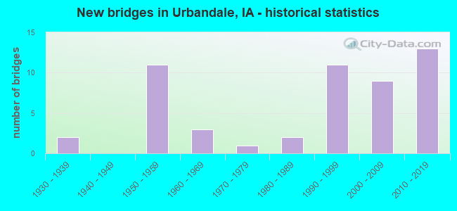
- New bridges - historical statistics
- 21930-1939
- 111950-1959
- 31960-1969
- 11970-1979
- 21980-1989
- 111990-1999
- 92000-2009
- 132010-2019

- Reconstructed bridges - Historical Statistics
- 11970-1979
- 31980-1989
- 21990-1999
- 02000-2009
- 12010-2019


- Bridge Condition - Deck
- 10.3%Excellent
- 41.4%Very good
- 24.1%Good
- 17.2%Satisfactory
- 6.9%Fair

- Bridge Condition - Superstructure
- 6.9%Excellent
- 48.3%Very good
- 34.5%Good
- 6.9%Satisfactory
- 3.4%Fair

- Bridge Condition - Substructure
- 10.3%Excellent
- 55.2%Very good
- 13.8%Good
- 17.2%Satisfactory
- 3.4%Serious

- Bridge Condition - Channel
- 54.2%Very good
- 8.3%Good
- 33.3%Satisfactory
- 4.2%Fair

- Bridge Condition - Culverts
- 12.5%Good
- 75.0%Satisfactory
- 12.5%Fair
Find on map >> Show street view
Structure Number: 1143, Location: O37600434 (Lat: 41.629306, Lng: -93.764150), Route carried "on" structure: City street , Year Built: 1960, Status: Open, Structure Length: 1.55m (5.09ft), Average Daily Traffic: 12,000 (year 2016), Average Future Daily Traffic: 12,000 (year 2040), Design Load: HS 20, Features Intersected: N WALNUT CREEK, Facility Carried by Structure: DOUGLAS AVE
Minimum Vertical Clearance: 30+ m (98+ ft), Kilometerpoint: 1.117, Lanes on structure: 4, Base Highway Network: Yes, Owner: City or Municipal Highway Agency, Approaching Roadway Width: 32.9m (107.9ft), Skew: 23 degrees, Material/Design: Concrete continuous, Design/Construction: Culvert, Number Of Spans In Main Unit: 3, Length of Maximum Span: 5.5m (18.0ft)
Condition: Channel: Satisfactory, Culverts: Fair, Operating Rating: 30.5 metric tons, Method Used To Determine Operating Rating: Load and Resistance Factor Rating (LRFR) rating reported by rating factor(RF) method using HL-93 loadings, Inventory Rating: 24.3 metric tons, Method Used To Determine Inventory Rating: Load and Resistance Factor Rating (LRFR) rating reported by rating factor(RF) method using HL-93 loadings, Structural Evaluation: Somewhat better than minimum adequacy, Waterway Adequacy: Equal to present minimum criteria, Approach Roadway Alignment: Equal to present desirable criteria, Designated Inspection Frequency: Every 24 months, Inspection Date: June 2020
Find on map >> Show street view
Structure Number: 1146, Location: O62400495 (Lat: 41.623589, Lng: -93.736525), Route carried "on" structure: City street , Year Built: 1968, Status: Open, Structure Length: 1.55m (5.09ft), Average Daily Traffic: 21,700 (year 2012), Average Future Daily Traffic: 21,700 (year 2040), Features Intersected: N WALNUT CREEK, Facility Carried by Structure: 86TH ST
Minimum Vertical Clearance: 30+ m (98+ ft), Kilometerpoint: 0.967, Lanes on structure: 4, Base Highway Network: Yes, Owner: City or Municipal Highway Agency, Approaching Roadway Width: 15.2m (49.9ft), Skew: 1 degrees, Material/Design: Concrete continuous, Design/Construction: Culvert, Number Of Spans In Main Unit: 3, Length of Maximum Span: 5.5m (18.0ft)
Condition: Channel: Satisfactory, Culverts: Satisfactory, Operating Rating: 21.7 metric tons, Method Used To Determine Operating Rating: Load and Resistance Factor Rating (LRFR) rating reported by rating factor(RF) method using HL-93 loadings, Inventory Rating: 16.8 metric tons, Method Used To Determine Inventory Rating: Load and Resistance Factor Rating (LRFR) rating reported by rating factor(RF) method using HL-93 loadings, Structural Evaluation: Meets minimum limits, Waterway Adequacy: Equal to present minimum criteria, Approach Roadway Alignment: Equal to present minimum criteria, Length Of Structure Improvement: 7.70m (25.26ft), Designated Inspection Frequency: Every 24 months, Inspection Date: June 2020, Bridge Improvement Cost: $153,000, Roadway Improvement Cost: $15,000
Find on map >> Show street view
Structure Number: 40395, Location: 0.9 MILE W OF W JCT IA 28 (Lat: 41.614667, Lng: -93.722097), Route carried "on" structure: US 6, Year Built: 1937, Year Reconstructed: 1970, Status: Open, Structure Length: 1.10m (3.61ft), Average Daily Traffic: 18,000 (year 2020), Truck Traffic: 2%, Average Future Daily Traffic: 18,000 (year 2042), Design Load: H 20, Features Intersected: DRAINAGE DITCH
Minimum Vertical Clearance: 30+ m (98+ ft), Kilometerpoint: 218.879, Lanes on structure: 6, Base Highway Network: Yes, Owner: State Highway Agency, Approaching Roadway Width: 21.3m (69.9ft), Skew: 24 degrees, Material/Design: Concrete continuous, Design/Construction: Culvert, Number Of Spans In Main Unit: 2, Length of Maximum Span: 3.0m (9.8ft)
Condition: Channel: Satisfactory, Culverts: Satisfactory, Operating Rating: 24.5 metric tons, Method Used To Determine Operating Rating: Field evaluation and documented engineering judgment, Inventory Rating: 18.1 metric tons, Method Used To Determine Inventory Rating: Field evaluation and documented engineering judgment, Structural Evaluation: Meets minimum limits, Waterway Adequacy: Better than present minimum criteria, Approach Roadway Alignment: Equal to present desirable criteria, Designated Inspection Frequency: Every 24 months, Inspection Date: January 2022
Find on map >> Show street view
Structure Number: 4131, Location: AT JCT. US 6 (Lat: 41.615131, Lng: -93.776958), Route carried "on" structure: Interstate 80, Year Built: 1958, Year Reconstructed: 1989, Status: Open, Structure Length: 5.30m (17.39ft), Average Daily Traffic: 42,300 (year 2020), Truck Traffic: 18%, Average Future Daily Traffic: 42,300 (year 2041), Design Load: HS 20, Features Intersected: US 6
Minimum Vertical Clearance: 30+ m (98+ ft), Kilometerpoint: 292.326, Lanes on structure: 3, Lanes under structure: 6, Owner: State Highway Agency, Approaching Roadway Width: 20.7m (67.9ft), Material/Design: Steel continuous, Design/Construction: Stringer/Multi-beam, Number Of Spans In Main Unit: 4, Length of Maximum Span: 14.6m (47.9ft), Curb-To-Curb Width: 19.1m (62.7ft), Out-to-Out Width: 20.0m (65.6ft)
Condition: Deck: Good, Superstructure: Satisfactory, Substructure: Satisfactory, Operating Rating: 64.9 metric tons, Method Used To Determine Operating Rating: Load Factor (LF), Inventory Rating: 38.9 metric tons, Method Used To Determine Inventory Rating: Load Factor (LF), Structural Evaluation: Equal to present minimum criteria, Deck Geometry: Superior to present desirable criteria, Underclear: High priority of corrective action, Approach Roadway Alignment: Equal to present desirable criteria, Designated Inspection Frequency: Every 24 months, Inspection Date: March 2021, Deck Structure Type: Concrete Cast-file-Place, Wearing Surface/Protective System: Wearing Surface: Monolithic Concrete, Deck Protection: Epoxy Coated Reinforcing
Find on map >> Show street view
Structure Number: 41331, Location: At JUNCTION I-80 & I-35 (Lat: 41.629386, Lng: -93.777547), Route carried "on" structure: City street , Year Built: 2002, Status: Open, Structure Length: 8.92m (29.27ft), Average Daily Traffic: 9,100 (year 2016), Average Future Daily Traffic: 9,100 (year 2042), Design Load: HS 20, Features Intersected: I 35 & I 80, Facility Carried by Structure: DOUGLAS AVE
Minimum Vertical Clearance: 30+ m (98+ ft), Kilometerpoint: 0.000, Lanes on structure: 6, Lanes under structure: 8, Base Highway Network: Yes, Owner: State Highway Agency, Approaching Roadway Width: 30.6m (100.4ft), Skew: 20 degrees, Material/Design: Steel continuous, Design/Construction: Stringer/Multi-beam, Number Of Spans In Main Unit: 2, Length of Maximum Span: 44.6m (146.3ft), Curb or Sidewalk Widths: Left: 0.0m, Right: 4.2m (13.8ft), Curb-To-Curb Width: 28.8m (94.5ft), Out-to-Out Width: 34.3m (112.5ft)
Condition: Deck: Very good, Superstructure: Good, Substructure: Very good, Operating Rating: 73.4 metric tons, Method Used To Determine Operating Rating: Load Factor (LF), Inventory Rating: 44.0 metric tons, Method Used To Determine Inventory Rating: Load Factor (LF), Structural Evaluation: Better than present minimum criteria, Deck Geometry: Superior to present desirable criteria, Underclear: Somewhat better than minimum adequacy, Approach Roadway Alignment: Equal to present desirable criteria, Designated Inspection Frequency: Every 24 months, Inspection Date: Febuary 2022, Deck Structure Type: Concrete Cast-file-Place, Wearing Surface/Protective System: Wearing Surface: Monolithic Concrete, Deck Protection: Epoxy Coated Reinforcing
Find on map >> Show street view
Structure Number: 41341, Location: 0.4 mi. W of Jct. IA #141 (Lat: 41.644000, Lng: -93.777603), Route carried "on" structure: City street , Year Built: 2006, Status: Open, Structure Length: 8.29m (27.20ft), Average Daily Traffic: 12,800 (year 2016), Average Future Daily Traffic: 12,800 (year 2040), Design Load: HS 20, Features Intersected: I-35 AND I-80, Facility Carried by Structure: MEREDITH DR
Minimum Vertical Clearance: 30+ m (98+ ft), Kilometerpoint: 7.480, Lanes on structure: 4, Lanes under structure: 7, Owner: State Highway Agency, Approaching Roadway Width: 20.7m (67.9ft), Skew: 20 degrees, Material/Design: Prestressed concrete, Design/Construction: Stringer/Multi-beam, Number Of Spans In Main Unit: 2, Length of Maximum Span: 41.5m (136.2ft), Curb or Sidewalk Widths: Left: 3.0m (9.8ft), Right: 0.0m, Curb-To-Curb Width: 20.7m (67.9ft), Out-to-Out Width: 21.3m (69.9ft)
Condition: Deck: Very good, Superstructure: Good, Substructure: Very good, Operating Rating: 90.5 metric tons, Method Used To Determine Operating Rating: Load Factor (LF), Inventory Rating: 42.3 metric tons, Method Used To Determine Inventory Rating: Load Factor (LF), Structural Evaluation: Better than present minimum criteria, Deck Geometry: Superior to present desirable criteria, Underclear: Somewhat better than minimum adequacy, Approach Roadway Alignment: Equal to present desirable criteria, Designated Inspection Frequency: Every 24 months, Inspection Date: July 2020, Deck Structure Type: Concrete Cast-file-Place, Wearing Surface/Protective System: Wearing Surface: Monolithic Concrete, Deck Protection: Epoxy Coated Reinforcing
Find on map >> Show street view
Structure Number: 4135, Location: At the Jct. IA 141 (Lat: 41.648739, Lng: -93.774047), Route carried "on" structure: Interstate 80, Year Built: 1958, Year Reconstructed: 1998, Status: Open, Structure Length: 7.68m (25.20ft), Average Daily Traffic: 30,700 (year 2020), Truck Traffic: 23%, Average Future Daily Traffic: 30,700 (year 2041), Design Load: HS 20, Features Intersected: NS RR & IA 141
Minimum Vertical Clearance: 30+ m (98+ ft), Kilometerpoint: 204.643, Lanes on structure: 4, Lanes under structure: 4, Base Highway Network: Yes, Owner: State Highway Agency, Approaching Roadway Width: 20.7m (67.9ft), Skew: 1 degrees, Material/Design: Prestressed concrete, Design/Construction: Stringer/Multi-beam, Number Of Spans In Main Unit: 4, Length of Maximum Span: 21.0m (68.9ft), Curb-To-Curb Width: 19.5m (64.0ft), Out-to-Out Width: 20.4m (66.9ft)
Condition: Deck: Satisfactory, Superstructure: Good, Substructure: Satisfactory, Operating Rating: 72.4 metric tons, Method Used To Determine Operating Rating: Load Factor (LF), Inventory Rating: 49.9 metric tons, Method Used To Determine Inventory Rating: Load Factor (LF), Structural Evaluation: Equal to present minimum criteria, Deck Geometry: Somewhat better than minimum adequacy, Underclear: High priority of corrective action, Approach Roadway Alignment: Better than present minimum criteria, Designated Inspection Frequency: Every 24 months, Inspection Date: April 2021, Deck Structure Type: Concrete Cast-file-Place, Wearing Surface/Protective System: Wearing Surface: Monolithic Concrete, Deck Protection: Epoxy Coated Reinforcing
Find on map >> Show street view
Structure Number: 4136, Location: AT JCT. IOWA 141 (Lat: 41.649383, Lng: -93.773569), Route carried "on" structure: Interstate 80, Year Built: 1958, Year Reconstructed: 1998, Status: Open, Structure Length: 7.73m (25.36ft), Average Daily Traffic: 30,700 (year 2020), Truck Traffic: 23%, Average Future Daily Traffic: 30,700 (year 2041), Design Load: HS 20, Features Intersected: NS RR & IA 141
Minimum Vertical Clearance: 30+ m (98+ ft), Kilometerpoint: 288.436, Lanes on structure: 4, Lanes under structure: 4, Owner: State Highway Agency, Approaching Roadway Width: 20.7m (67.9ft), Skew: 1 degrees, Material/Design: Prestressed concrete, Design/Construction: Stringer/Multi-beam, Number Of Spans In Main Unit: 4, Length of Maximum Span: 21.0m (68.9ft), Curb-To-Curb Width: 19.6m (64.3ft), Out-to-Out Width: 20.6m (67.6ft)
Condition: Deck: Satisfactory, Superstructure: Good, Substructure: Satisfactory, Operating Rating: 70.8 metric tons, Method Used To Determine Operating Rating: Load Factor (LF), Inventory Rating: 39.4 metric tons, Method Used To Determine Inventory Rating: Load Factor (LF), Structural Evaluation: Equal to present minimum criteria, Deck Geometry: Somewhat better than minimum adequacy, Underclear: High priority of corrective action, Approach Roadway Alignment: Equal to present desirable criteria, Designated Inspection Frequency: Every 24 months, Inspection Date: April 2021, Deck Structure Type: Concrete Cast-file-Place, Wearing Surface/Protective System: Wearing Surface: Monolithic Concrete, Deck Protection: Epoxy Coated Reinforcing
Find on map >> Show street view
Structure Number: 41381, Location: 1.0 MI. E OF JCT. 141 (Lat: 41.651322, Lng: -93.755861), Route carried "on" structure: City street , Year Built: 2016, Status: Open, Structure Length: 10.16m (33.33ft), Average Daily Traffic: 2,750 (year 2018), Average Future Daily Traffic: 2,750 (year 2040), Design Load: HL 93, Features Intersected: I 35 & I 80, Facility Carried by Structure: NW 100TH ST NB
Minimum Vertical Clearance: 30+ m (98+ ft), Kilometerpoint: 3.616, Lanes on structure: 2, Lanes under structure: 7, Owner: State Highway Agency, Approaching Roadway Width: 29.9m (98.1ft), Skew: 20 degrees, Material/Design: Steel continuous, Design/Construction: Stringer/Multi-beam, Number Of Spans In Main Unit: 2, Length of Maximum Span: 50.3m (165.0ft), Curb or Sidewalk Widths: Left: 0.0m, Right: 3.7m (12.1ft), Curb-To-Curb Width: 14.3m (46.9ft), Out-to-Out Width: 20.4m (66.9ft)
Condition: Deck: Excellent, Superstructure: Very good, Substructure: Excellent, Operating Rating: 42.1 metric tons, Method Used To Determine Operating Rating: Assigned ratings based on Load and Resistance Factor Design (LRFD) reported by rating factor (RF) using HL93 loadings, Inventory Rating: 32.4 metric tons, Method Used To Determine Inventory Rating: Assigned ratings based on Load and Resistance Factor Design (LRFD) reported by rating factor (RF) using HL93 loadings, Structural Evaluation: Equal to present desirable criteria, Deck Geometry: Superior to present desirable criteria, Underclear: Equal to present minimum criteria, Approach Roadway Alignment: Equal to present desirable criteria, Designated Inspection Frequency: Every 24 months, Inspection Date: July 2020, Deck Structure Type: Concrete Cast-file-Place, Wearing Surface/Protective System: Wearing Surface: Monolithic Concrete, Deck Protection: Epoxy Coated Reinforcing
Find on map >> Show street view
Structure Number: 414, Location: 1.1 MILES E OF JCT IA 141 (Lat: 41.651592, Lng: -93.753892), Route carried "on" structure: Interstate 80, Year Built: 1958, Year Reconstructed: 2016, Status: Open, Structure Length: 0.82m (2.69ft), Average Daily Traffic: 72,100 (year 2020), Truck Traffic: 22%, Average Future Daily Traffic: 72,100 (year 2041), Design Load: H 20, Features Intersected: N WALNUT CREEK
Minimum Vertical Clearance: 30+ m (98+ ft), Kilometerpoint: 206.398, Lanes on structure: 8, Base Highway Network: Yes, Owner: State Highway Agency, Approaching Roadway Width: 36.6m (120.1ft), Skew: 34 degrees, Material/Design: Concrete continuous, Design/Construction: Culvert, Number Of Spans In Main Unit: 2, Length of Maximum Span: 3.7m (12.1ft)
Condition: Channel: Good, Culverts: Satisfactory, Operating Rating: 24.5 metric tons, Method Used To Determine Operating Rating: Field evaluation and documented engineering judgment, Inventory Rating: 18.1 metric tons, Method Used To Determine Inventory Rating: Field evaluation and documented engineering judgment, Structural Evaluation: Meets minimum limits, Waterway Adequacy: Better than present minimum criteria, Approach Roadway Alignment: Equal to present desirable criteria, Designated Inspection Frequency: Every 24 months, Inspection Date: March 2021
Find on map >> Show street view
Structure Number: 41411, Location: 2.0 MI. W OF IOWA 28 (Lat: 41.651808, Lng: -93.736372), Route carried "on" structure: City street , Year Built: 1994, Status: Open, Structure Length: 8.47m (27.79ft), Average Daily Traffic: 14,600 (year 2016), Average Future Daily Traffic: 14,600 (year 2041), Design Load: HS 20, Features Intersected: I-35 & I-80, Facility Carried by Structure: 86TH ST
Minimum Vertical Clearance: 30+ m (98+ ft), Kilometerpoint: 4.115, Lanes on structure: 4, Lanes under structure: 8, Base Highway Network: Yes, Owner: State Highway Agency, Approaching Roadway Width: 25.6m (84.0ft), Skew: 20 degrees, Material/Design: Prestressed concrete, Design/Construction: Stringer/Multi-beam, Number Of Spans In Main Unit: 4, Length of Maximum Span: 28.0m (91.9ft), Curb-To-Curb Width: 25.6m (84.0ft), Out-to-Out Width: 26.6m (87.3ft)
Condition: Deck: Good, Superstructure: Very good, Substructure: Good, Operating Rating: 70.5 metric tons, Method Used To Determine Operating Rating: Load Factor (LF), Inventory Rating: 35.4 metric tons, Method Used To Determine Inventory Rating: Load Factor (LF), Structural Evaluation: Better than present minimum criteria, Deck Geometry: Superior to present desirable criteria, Underclear: Equal to present minimum criteria, Approach Roadway Alignment: Equal to present minimum criteria, Designated Inspection Frequency: Every 24 months, Inspection Date: November 2021, Deck Structure Type: Concrete Cast-file-Place, Wearing Surface/Protective System: Wearing Surface: Monolithic Concrete, Deck Protection: Epoxy Coated Reinforcing
Find on map >> Show street view
Structure Number: 4142, Location: 1.0 MILE W OF JCT. IA 28 (Lat: 41.652628, Lng: -93.717308), Route carried "on" structure: Interstate 80, Year Built: 1958, Year Reconstructed: 1994, Status: Open, Structure Length: 3.87m (12.70ft), Average Daily Traffic: 40,550 (year 2020), Truck Traffic: 20%, Average Future Daily Traffic: 40,550 (year 2040), Design Load: HS 20, Features Intersected: NW 72ND ST
Minimum Vertical Clearance: 30+ m (98+ ft), Kilometerpoint: 209.448, Lanes on structure: 3, Lanes under structure: 2, Base Highway Network: Yes, Owner: State Highway Agency, Approaching Roadway Width: 12.2m (40.0ft), Material/Design: Prestressed concrete, Design/Construction: Stringer/Multi-beam, Number Of Spans In Main Unit: 3, Length of Maximum Span: 13.4m (44.0ft), Curb-To-Curb Width: 19.0m (62.3ft), Out-to-Out Width: 20.4m (66.9ft)
Condition: Deck: Satisfactory, Superstructure: Good, Substructure: Good, Operating Rating: 47.6 metric tons, Method Used To Determine Operating Rating: Load Factor (LF), Inventory Rating: 34.1 metric tons, Method Used To Determine Inventory Rating: Load Factor (LF), Structural Evaluation: Better than present minimum criteria, Deck Geometry: Superior to present desirable criteria, Underclear: High priority of corrective action, Approach Roadway Alignment: Equal to present desirable criteria, Designated Inspection Frequency: Every 24 months, Inspection Date: September 2020, Deck Structure Type: Concrete Cast-file-Place, Wearing Surface/Protective System: Wearing Surface: Low Slump Concrete, Deck Protection: Epoxy Coated Reinforcing
Find on map >> Show street view
Structure Number: 4143, Location: 1.0 MILE WEST JCT IA 28 (Lat: 41.652822, Lng: -93.716861), Route carried "on" structure: Interstate 80, Year Built: 1958, Year Reconstructed: 1991, Status: Open, Structure Length: 3.81m (12.50ft), Average Daily Traffic: 40,550 (year 2020), Truck Traffic: 20%, Average Future Daily Traffic: 40,550 (year 2040), Design Load: HS 20, Features Intersected: NW 72ND ST
Minimum Vertical Clearance: 30+ m (98+ ft), Kilometerpoint: 283.655, Lanes on structure: 3, Lanes under structure: 2, Owner: State Highway Agency, Approaching Roadway Width: 18.3m (60.0ft), Material/Design: Prestressed concrete, Design/Construction: Stringer/Multi-beam, Number Of Spans In Main Unit: 3, Length of Maximum Span: 13.4m (44.0ft), Curb-To-Curb Width: 19.0m (62.3ft), Out-to-Out Width: 20.4m (66.9ft)
Condition: Deck: Fair, Superstructure: Good, Substructure: Satisfactory, Operating Rating: 61.9 metric tons, Method Used To Determine Operating Rating: Load Factor (LF), Inventory Rating: 33.7 metric tons, Method Used To Determine Inventory Rating: Load Factor (LF), Structural Evaluation: Equal to present minimum criteria, Deck Geometry: Superior to present desirable criteria, Underclear: High priority of corrective action, Approach Roadway Alignment: Equal to present desirable criteria, Designated Inspection Frequency: Every 24 months, Inspection Date: September 2020, Deck Structure Type: Concrete Cast-file-Place, Wearing Surface/Protective System: Wearing Surface: Low Slump Concrete, Deck Protection: Epoxy Coated Reinforcing
Find on map >> Show street view
Structure Number: 41441, Location: At jct. IA 28 (Lat: 41.652047, Lng: -93.698161), Route carried "on" structure: Interstate 80, Year Built: 1999, Status: Open, Structure Length: 8.11m (26.61ft), Average Daily Traffic: 32,150 (year 2020), Truck Traffic: 25%, Average Future Daily Traffic: 32,150 (year 2041), Design Load: HS 20, Features Intersected: IA 28
Minimum Vertical Clearance: 30+ m (98+ ft), Kilometerpoint: 211.045, Lanes on structure: 3, Lanes under structure: 8, Base Highway Network: Yes, Owner: State Highway Agency, Approaching Roadway Width: 19.8m (65.0ft), Material/Design: Steel continuous, Design/Construction: Stringer/Multi-beam, Number Of Spans In Main Unit: 2, Length of Maximum Span: 39.9m (130.9ft), Curb-To-Curb Width: 18.4m (60.4ft), Out-to-Out Width: 19.3m (63.3ft)
Condition: Deck: Good, Superstructure: Very good, Substructure: Good, Operating Rating: 64.8 metric tons, Method Used To Determine Operating Rating: Load Factor (LF), Inventory Rating: 38.9 metric tons, Method Used To Determine Inventory Rating: Load Factor (LF), Structural Evaluation: Better than present minimum criteria, Deck Geometry: Equal to present desirable criteria, Underclear: Superior to present desirable criteria, Approach Roadway Alignment: Equal to present desirable criteria, Designated Inspection Frequency: Every 24 months, Inspection Date: May 2021, Deck Structure Type: Concrete Cast-file-Place, Wearing Surface/Protective System: Wearing Surface: Monolithic Concrete, Deck Protection: Epoxy Coated Reinforcing
Find on map >> Show street view
Structure Number: 41451, Location: At the Jct. IA 28 (Lat: 41.652183, Lng: -93.697175), Route carried "on" structure: Interstate 80, Year Built: 1999, Status: Open, Structure Length: 8.11m (26.61ft), Average Daily Traffic: 33,050 (year 2020), Truck Traffic: 24%, Average Future Daily Traffic: 33,050 (year 2041), Design Load: HS 20, Features Intersected: IA 28
Minimum Vertical Clearance: 30+ m (98+ ft), Kilometerpoint: 282.013, Lanes on structure: 3, Lanes under structure: 8, Owner: State Highway Agency, Approaching Roadway Width: 19.8m (65.0ft), Material/Design: Steel continuous, Design/Construction: Stringer/Multi-beam, Number Of Spans In Main Unit: 2, Length of Maximum Span: 39.9m (130.9ft), Curb-To-Curb Width: 18.4m (60.4ft), Out-to-Out Width: 19.3m (63.3ft)
Condition: Deck: Satisfactory, Superstructure: Very good, Substructure: Good, Operating Rating: 64.8 metric tons, Method Used To Determine Operating Rating: Load Factor (LF), Inventory Rating: 38.9 metric tons, Method Used To Determine Inventory Rating: Load Factor (LF), Structural Evaluation: Better than present minimum criteria, Deck Geometry: Equal to present desirable criteria, Underclear: Superior to present desirable criteria, Approach Roadway Alignment: Equal to present desirable criteria, Designated Inspection Frequency: Every 24 months, Inspection Date: May 2021, Deck Structure Type: Concrete Cast-file-Place, Wearing Surface/Protective System: Wearing Surface: Monolithic Concrete, Deck Protection: Epoxy Coated Reinforcing
Find on map >> Show street view
Structure Number: 13154, Location: 079260902 (Lat: 41.671453, Lng: -93.891692), Route carried "on" structure: County highway , Year Built: 1969, Status: Open, Structure Length: 0.79m (2.59ft), Average Daily Traffic: 1,250 (year 2016), Truck Traffic: 15%, Average Future Daily Traffic: 1,250 (year 2039), Design Load: H 20, Features Intersected: WALNUT CREEK, Facility Carried by Structure: FM
Minimum Vertical Clearance: 30+ m (98+ ft), Kilometerpoint: 5.887, Lanes on structure: 2, Owner: County Highway Agency, Approaching Roadway Width: 10.4m (34.1ft), Material/Design: Concrete, Design/Construction: Slab, Number Of Spans In Main Unit: 1, Length of Maximum Span: 7.3m (24.0ft), Curb-To-Curb Width: 8.6m (28.2ft), Out-to-Out Width: 9.2m (30.2ft)
Condition: Deck: Satisfactory, Superstructure: Satisfactory, Substructure: Satisfactory, Channel: Good, Operating Rating: 50.7 metric tons, Method Used To Determine Operating Rating: Allowable Stress (AS), Inventory Rating: 29.4 metric tons, Method Used To Determine Inventory Rating: Allowable Stress (AS), Structural Evaluation: Equal to present minimum criteria, Deck Geometry: Somewhat better than minimum adequacy, Waterway Adequacy: Better than present minimum criteria, Approach Roadway Alignment: Equal to present desirable criteria, Length Of Structure Improvement: 2.50m (8.20ft), Designated Inspection Frequency: Every 24 months, Inspection Date: November 2019, Bridge Improvement Cost: $15,000, Roadway Improvement Cost: $2,000, Deck Structure Type: Concrete Cast-file-Place, Wearing Surface/Protective System: Wearing Surface: Low Slump Concrete
Find on map >> Show street view
Structure Number: 13155, Location: 079261101 (Lat: 41.672739, Lng: -93.848894), Route carried "on" structure: County highway , Year Built: 1936, Status: Posted for load, Structure Length: 1.28m (4.20ft), Average Daily Traffic: 100 (year 2016), Average Future Daily Traffic: 100 (year 2039), Features Intersected: WALNUT CREEK, Facility Carried by Structure: COUNTY ROAD
Minimum Vertical Clearance: 30+ m (98+ ft), Kilometerpoint: 23.384, Lanes on structure: 2, Owner: County Highway Agency, Approaching Roadway Width: 7.3m (24.0ft), Material/Design: Steel, Design/Construction: Stringer/Multi-beam, Number Of Spans In Main Unit: 1, Length of Maximum Span: 12.5m (41.0ft), Curb-To-Curb Width: 5.8m (19.0ft), Out-to-Out Width: 6.2m (20.3ft)
Condition: Deck: Fair, Superstructure: Fair, Substructure: Serious, Channel: Fair, Operating Rating: 12.2 metric tons, Method Used To Determine Operating Rating: Allowable Stress (AS), Inventory Rating: 7.5 metric tons, Method Used To Determine Inventory Rating: Allowable Stress (AS), Structural Evaluation: High priority of replacement, Deck Geometry: Meets minimum limits, Waterway Adequacy: Equal to present minimum criteria, Approach Roadway Alignment: Equal to present minimum criteria, Bridge Posting: Required (Relationship of Operating Rating to Maximum Legal Load: > 39.9% below), Length Of Structure Improvement: 7.00m (22.97ft), Designated Inspection Frequency: Every 24 months, Other Special Inspection Frequency: Every 12 months, Inspection Date: November 2019, Other Special Inspection Date: November 2020, Bridge Improvement Cost: $235,000, Roadway Improvement Cost: $24,000, Deck Structure Type: Wood or Timber, Wearing Surface/Protective System: Wearing Surface: Bituminous
Find on map >> Show street view
Structure Number: 13156, Location: 079261104 (Lat: 41.662208, Lng: -93.852833), Route carried "on" structure: County highway , Year Built: 1975, Status: Open, Structure Length: 0.76m (2.49ft), Average Daily Traffic: 3,030 (year 2016), Truck Traffic: 10%, Average Future Daily Traffic: 3,030 (year 2037), Design Load: HS 20, Features Intersected: WALNUT CREEK, Facility Carried by Structure: R 30 (W AVE)
Minimum Vertical Clearance: 30+ m (98+ ft), Kilometerpoint: 0.436, Lanes on structure: 2, Owner: County Highway Agency, Approaching Roadway Width: 12.2m (40.0ft), Material/Design: Concrete continuous, Design/Construction: Culvert, Number Of Spans In Main Unit: 2, Length of Maximum Span: 3.7m (12.1ft)
Condition: Channel: Satisfactory, Culverts: Satisfactory, Operating Rating: 44.1 metric tons, Method Used To Determine Operating Rating: Assigned rating based on Load Factor Design (LFD) reported in metric tons, Inventory Rating: 32.7 metric tons, Method Used To Determine Inventory Rating: Assigned rating based on Load Factor Design (LFD) reported in metric tons, Structural Evaluation: Equal to present minimum criteria, Waterway Adequacy: Better than present minimum criteria, Approach Roadway Alignment: Equal to present desirable criteria, Length Of Structure Improvement: 2.00m (6.56ft), Designated Inspection Frequency: Every 48 months, Inspection Date: November 2017, Bridge Improvement Cost: $15,000, Roadway Improvement Cost: $2,000
Find on map >> Show street view
Structure Number: 131572, Location: 200 ft North of Brookview (Lat: 41.651944, Lng: -93.833686), Route carried "on" structure: City street , Year Built: 2015, Status: Open, Structure Length: 5.21m (17.09ft), Average Daily Traffic: 275 (year 2004), Average Future Daily Traffic: 275 (year 2040), Design Load: HL 93, Features Intersected: WALNUT CREEK, Facility Carried by Structure: 156TH ST SB
Minimum Vertical Clearance: 30+ m (98+ ft), Kilometerpoint: 2.298, Lanes on structure: 2, Owner: City or Municipal Highway Agency, Approaching Roadway Width: 7.6m (24.9ft), Skew: 11 degrees, Material/Design: Concrete continuous, Design/Construction: Slab, Number Of Spans In Main Unit: 3, Length of Maximum Span: 20.7m (67.9ft), Curb or Sidewalk Widths: Left: 3.0m (9.8ft), Right: 0.0m, Curb-To-Curb Width: 9.1m (29.9ft), Out-to-Out Width: 13.4m (44.0ft)
Condition: Deck: Very good, Superstructure: Very good, Substructure: Very good, Channel: Very good, Operating Rating: 43.7 metric tons, Method Used To Determine Operating Rating: Assigned ratings based on Load and Resistance Factor Design (LRFD) reported by rating factor (RF) using HL93 loadings, Inventory Rating: 32.4 metric tons, Method Used To Determine Inventory Rating: Assigned ratings based on Load and Resistance Factor Design (LRFD) reported by rating factor (RF) using HL93 loadings, Structural Evaluation: Equal to present desirable criteria, Deck Geometry: Meets minimum limits, Waterway Adequacy: Equal to present desirable criteria, Approach Roadway Alignment: Equal to present desirable criteria, Designated Inspection Frequency: Every 24 months, Inspection Date: June 2020, Deck Structure Type: Concrete Cast-file-Place, Wearing Surface/Protective System: Wearing Surface: Monolithic Concrete, Deck Protection: Epoxy Coated Reinforcing
Find on map >> Show street view
Structure Number: 131581, Location: P40000350 (Lat: 41.658192, Lng: -93.835997), Route carried "on" structure: City street , Year Built: 2007, Status: Open, Structure Length: 4.57m (14.99ft), Average Daily Traffic: 305 (year 2008), Average Future Daily Traffic: 305 (year 2040), Design Load: HS 20, Features Intersected: WALNUT CREEK, Facility Carried by Structure: WATERFORD RD WB
Minimum Vertical Clearance: 30+ m (98+ ft), Kilometerpoint: 1.794, Lanes on structure: 2, Owner: City or Municipal Highway Agency, Approaching Roadway Width: 8.8m (28.9ft), Skew: 1 degrees, Material/Design: Concrete continuous, Design/Construction: Slab, Number Of Spans In Main Unit: 3, Length of Maximum Span: 17.7m (58.1ft), Curb or Sidewalk Widths: Left: 0.0m, Right: 3.0m (9.8ft), Curb-To-Curb Width: 9.8m (32.2ft), Out-to-Out Width: 14.0m (45.9ft)
Condition: Deck: Good, Superstructure: Good, Substructure: Very good, Channel: Very good, Operating Rating: 55.4 metric tons, Method Used To Determine Operating Rating: Load Factor (LF), Inventory Rating: 33.2 metric tons, Method Used To Determine Inventory Rating: Load Factor (LF), Structural Evaluation: Better than present minimum criteria, Deck Geometry: Better than present minimum criteria, Waterway Adequacy: Equal to present desirable criteria, Approach Roadway Alignment: Better than present minimum criteria, Designated Inspection Frequency: Every 24 months, Inspection Date: June 2020, Deck Structure Type: Concrete Cast-file-Place, Wearing Surface/Protective System: Wearing Surface: Monolithic Concrete, Deck Protection: Epoxy Coated Reinforcing
Find on map >> Show street view
Structure Number: 131591, Location: 079261502 (Lat: 41.653914, Lng: -93.872250), Route carried "on" structure: County highway , Year Built: 1988, Status: Open, Structure Length: 2.38m (7.81ft), Average Daily Traffic: 50 (year 2012), Average Future Daily Traffic: 50 (year 2037), Design Load: HS 20, Features Intersected: WALNUT CREEK, Facility Carried by Structure: COUNTY ROAD
Minimum Vertical Clearance: 30+ m (98+ ft), Kilometerpoint: 2.736, Lanes on structure: 2, Owner: County Highway Agency, Approaching Roadway Width: 7.9m (25.9ft), Material/Design: Concrete continuous, Design/Construction: Slab, Number Of Spans In Main Unit: 3, Length of Maximum Span: 8.8m (28.9ft), Curb-To-Curb Width: 9.3m (30.5ft), Out-to-Out Width: 10.1m (33.1ft)
Condition: Deck: Good, Superstructure: Good, Substructure: Very good, Channel: Satisfactory, Operating Rating: 62.2 metric tons, Method Used To Determine Operating Rating: Allowable Stress (AS), Inventory Rating: 37.1 metric tons, Method Used To Determine Inventory Rating: Allowable Stress (AS), Structural Evaluation: Better than present minimum criteria, Deck Geometry: Better than present minimum criteria, Waterway Adequacy: Equal to present desirable criteria, Approach Roadway Alignment: Better than present minimum criteria, Length Of Structure Improvement: 7.80m (25.59ft), Designated Inspection Frequency: Every 48 months, Inspection Date: December 2017, Bridge Improvement Cost: $15,000, Roadway Improvement Cost: $2,000, Deck Structure Type: Concrete Cast-file-Place, Wearing Surface/Protective System: Wearing Surface: Monolithic Concrete
Find on map >> Show street view
Structure Number: 281481, Location: O39400540 (Lat: 41.643906, Lng: -93.750097), Route carried "on" structure: City street , Year Built: 1989, Status: Open, Structure Length: 2.50m (8.20ft), Average Daily Traffic: 12,900 (year 2016), Average Future Daily Traffic: 12,900 (year 2040), Design Load: HS 20, Features Intersected: N WALNUT CREEK, Facility Carried by Structure: MEREDITH DR
Minimum Vertical Clearance: 30+ m (98+ ft), Kilometerpoint: 9.777, Lanes on structure: 2, Owner: City or Municipal Highway Agency, Approaching Roadway Width: 19.8m (65.0ft), Skew: 1 degrees, Material/Design: Concrete continuous, Design/Construction: Culvert, Number Of Spans In Main Unit: 3, Length of Maximum Span: 11.6m (38.1ft)
Condition: Channel: Satisfactory, Culverts: Satisfactory, Operating Rating: 65.7 metric tons, Method Used To Determine Operating Rating: Load Factor (LF), Inventory Rating: 39.3 metric tons, Method Used To Determine Inventory Rating: Load Factor (LF), Structural Evaluation: Equal to present minimum criteria, Waterway Adequacy: Somewhat better than minimum adequacy, Approach Roadway Alignment: Equal to present desirable criteria, Designated Inspection Frequency: Every 24 months, Inspection Date: June 2020
Find on map >> Show street view
Structure Number: 50414, Location: O38090555 (Lat: 41.637178, Lng: -93.746131), Route carried "on" structure: City street , Year Built: 1991, Status: Open, Structure Length: 2.29m (7.51ft), Average Daily Traffic: 2,060 (year 1996), Average Future Daily Traffic: 2,060 (year 2040), Design Load: HS 20, Features Intersected: N WALNUT CREEK, Facility Carried by Structure: AURORA AVE
Minimum Vertical Clearance: 30+ m (98+ ft), Kilometerpoint: 5.446, Lanes on structure: 2, Owner: City or Municipal Highway Agency, Approaching Roadway Width: 10.1m (33.1ft), Skew: 3 degrees, Material/Design: Concrete continuous, Design/Construction: Culvert, Number Of Spans In Main Unit: 4, Length of Maximum Span: 4.6m (15.1ft)
Condition: Channel: Satisfactory, Culverts: Satisfactory, Operating Rating: 36.6 metric tons, Method Used To Determine Operating Rating: Load Factor (LF), Inventory Rating: 21.9 metric tons, Method Used To Determine Inventory Rating: Load Factor (LF), Structural Evaluation: Somewhat better than minimum adequacy, Waterway Adequacy: Somewhat better than minimum adequacy, Approach Roadway Alignment: Equal to present minimum criteria, Designated Inspection Frequency: Every 24 months, Inspection Date: June 2020
Find on map >> Show street view
Structure Number: 504895, Location: O37550370 (Lat: 41.629306, Lng: -93.814761), Route carried "on" structure: City street , Year Built: 2006, Status: Open, Structure Length: 5.97m (19.59ft), Average Daily Traffic: 1,920 (year 2016), Average Future Daily Traffic: 1,920 (year 2040), Design Load: HS 20, Features Intersected: WALNUT CREEK, Facility Carried by Structure: DOUGLAS PKWY
Minimum Vertical Clearance: 30+ m (98+ ft), Kilometerpoint: 2.371, Lanes on structure: 4, Owner: City or Municipal Highway Agency, Approaching Roadway Width: 17.7m (58.1ft), Skew: 23 degrees, Material/Design: Prestressed concrete, Design/Construction: Stringer/Multi-beam, Number Of Spans In Main Unit: 3, Length of Maximum Span: 21.0m (68.9ft), Curb or Sidewalk Widths: Left: 1.2m (3.9ft), Right: 2.4m (7.9ft), Curb-To-Curb Width: 16.8m (55.1ft), Out-to-Out Width: 23.5m (77.1ft)
Condition: Deck: Very good, Superstructure: Very good, Substructure: Very good, Channel: Very good, Operating Rating: 54.3 metric tons, Method Used To Determine Operating Rating: Load Factor (LF), Inventory Rating: 32.6 metric tons, Method Used To Determine Inventory Rating: Load Factor (LF), Structural Evaluation: Equal to present desirable criteria, Deck Geometry: Somewhat better than minimum adequacy, Waterway Adequacy: Equal to present desirable criteria, Approach Roadway Alignment: Equal to present desirable criteria, Designated Inspection Frequency: Every 24 months, Inspection Date: June 2020, Deck Structure Type: Concrete Cast-file-Place, Wearing Surface/Protective System: Wearing Surface: Monolithic Concrete, Deck Protection: Epoxy Coated Reinforcing
Find on map >> Show street view
Structure Number: 50493, Location: P55000600 (Lat: 41.633053, Lng: -93.833444), Route carried "on" structure: City street , Year Built: 2007, Status: Open, Structure Length: 3.75m (12.30ft), Average Daily Traffic: 1,335 (year 2016), Average Future Daily Traffic: 1,335 (year 2040), Design Load: HS 20, Features Intersected: LITTLE WALNUT CREEK, Facility Carried by Structure: 156TH ST
Minimum Vertical Clearance: 30+ m (98+ ft), Kilometerpoint: 1.220, Lanes on structure: 2, Owner: City or Municipal Highway Agency, Approaching Roadway Width: 7.9m (25.9ft), Material/Design: Concrete continuous, Design/Construction: Slab, Number Of Spans In Main Unit: 3, Length of Maximum Span: 14.3m (46.9ft), Curb or Sidewalk Widths: Left: 1.5m (4.9ft), Right: 0.0m, Curb-To-Curb Width: 9.8m (32.2ft), Out-to-Out Width: 12.5m (41.0ft)
Condition: Deck: Good, Superstructure: Good, Substructure: Very good, Channel: Very good, Operating Rating: 82.2 metric tons, Method Used To Determine Operating Rating: Load Factor (LF), Inventory Rating: 49.3 metric tons, Method Used To Determine Inventory Rating: Load Factor (LF), Structural Evaluation: Better than present minimum criteria, Deck Geometry: Meets minimum limits, Waterway Adequacy: Equal to present desirable criteria, Approach Roadway Alignment: Better than present minimum criteria, Designated Inspection Frequency: Every 24 months, Inspection Date: June 2020, Deck Structure Type: Concrete Cast-file-Place, Wearing Surface/Protective System: Wearing Surface: Monolithic Concrete, Deck Protection: Epoxy Coated Reinforcing
Find on map >> Show street view
Structure Number: 504935, Location: P55000600 (Lat: 41.633389, Lng: -93.833647), Route carried "on" structure: City street , Year Built: 2007, Status: Open, Structure Length: 3.75m (12.30ft), Average Daily Traffic: 1,285 (year 2016), Average Future Daily Traffic: 1,285 (year 2040), Design Load: HS 20, Features Intersected: LITTLE WALNUT CREEK, Facility Carried by Structure: 156TH ST
Minimum Vertical Clearance: 30+ m (98+ ft), Kilometerpoint: 4.358, Lanes on structure: 2, Owner: City or Municipal Highway Agency, Approaching Roadway Width: 7.9m (25.9ft), Material/Design: Concrete continuous, Design/Construction: Slab, Number Of Spans In Main Unit: 3, Length of Maximum Span: 14.3m (46.9ft), Curb-To-Curb Width: 9.8m (32.2ft), Out-to-Out Width: 14.0m (45.9ft)
Condition: Deck: Good, Superstructure: Good, Substructure: Very good, Channel: Very good, Operating Rating: 82.2 metric tons, Method Used To Determine Operating Rating: Load Factor (LF), Inventory Rating: 49.3 metric tons, Method Used To Determine Inventory Rating: Load Factor (LF), Structural Evaluation: Better than present minimum criteria, Deck Geometry: Meets minimum limits, Waterway Adequacy: Equal to present desirable criteria, Approach Roadway Alignment: Better than present minimum criteria, Designated Inspection Frequency: Every 24 months, Inspection Date: June 2020, Deck Structure Type: Concrete Cast-file-Place, Wearing Surface/Protective System: Wearing Surface: Monolithic Concrete, Deck Protection: Epoxy Coated Reinforcing
Find on map >> Show street view
Structure Number: 50494, Location: O57000543 (Lat: 41.626439, Lng: -93.813369), Route carried "on" structure: City street , Year Built: 2006, Status: Open, Structure Length: 5.58m (18.31ft), Average Daily Traffic: 4,060 (year 2008), Average Future Daily Traffic: 4,060 (year 2040), Design Load: HS 20, Features Intersected: WALNUT CREEK, Facility Carried by Structure: 142ND ST
Minimum Vertical Clearance: 30+ m (98+ ft), Kilometerpoint: 1.299, Lanes on structure: 4, Owner: City or Municipal Highway Agency, Approaching Roadway Width: 15.9m (52.2ft), Skew: 21 degrees, Material/Design: Prestressed concrete, Design/Construction: Stringer/Multi-beam, Number Of Spans In Main Unit: 3, Length of Maximum Span: 21.0m (68.9ft), Curb or Sidewalk Widths: Left: 1.5m (4.9ft), Right: 1.5m (4.9ft), Curb-To-Curb Width: 16.8m (55.1ft), Out-to-Out Width: 22.3m (73.2ft)
Condition: Deck: Very good, Superstructure: Very good, Substructure: Very good, Channel: Very good, Operating Rating: 56.7 metric tons, Method Used To Determine Operating Rating: Load Factor (LF), Inventory Rating: 34.0 metric tons, Method Used To Determine Inventory Rating: Load Factor (LF), Structural Evaluation: Equal to present desirable criteria, Deck Geometry: Somewhat better than minimum adequacy, Waterway Adequacy: Equal to present desirable criteria, Approach Roadway Alignment: Better than present minimum criteria, Designated Inspection Frequency: Every 24 months, Inspection Date: June 2020, Deck Structure Type: Concrete Cast-file-Place, Wearing Surface/Protective System: Wearing Surface: Monolithic Concrete, Deck Protection: Epoxy Coated Reinforcing
Find on map >> Show street view
Structure Number: 505045, Location: AURORA AVE (Lat: 41.639728, Lng: -93.825425), Route carried "on" structure: City street , Year Built: 2012, Status: Open, Structure Length: 8.41m (27.59ft), Average Daily Traffic: 367 (year 2014), Average Future Daily Traffic: 367 (year 2040), Design Load: HL 93, Features Intersected: WALNUT CREEK, Facility Carried by Structure: AURORA AVE
Minimum Vertical Clearance: 30+ m (98+ ft), Kilometerpoint: 1.299, Lanes on structure: 2, Owner: City or Municipal Highway Agency, Approaching Roadway Width: 9.1m (29.9ft), Material/Design: Prestressed concrete, Design/Construction: Stringer/Multi-beam, Number Of Spans In Main Unit: 3, Length of Maximum Span: 27.9m (91.5ft), Curb or Sidewalk Widths: Left: 3.0m (9.8ft), Right: 1.5m (4.9ft), Curb-To-Curb Width: 9.1m (29.9ft), Out-to-Out Width: 15.2m (49.9ft)
Condition: Deck: Very good, Superstructure: Very good, Substructure: Very good, Channel: Very good, Operating Rating: 43.7 metric tons, Method Used To Determine Operating Rating: Assigned ratings based on Load and Resistance Factor Design (LRFD) reported by rating factor (RF) using HL93 loadings, Inventory Rating: 32.4 metric tons, Method Used To Determine Inventory Rating: Assigned ratings based on Load and Resistance Factor Design (LRFD) reported by rating factor (RF) using HL93 loadings, Structural Evaluation: Equal to present desirable criteria, Deck Geometry: Equal to present minimum criteria, Waterway Adequacy: Equal to present desirable criteria, Approach Roadway Alignment: Better than present minimum criteria, Designated Inspection Frequency: Every 24 months, Inspection Date: June 2020, Deck Structure Type: Concrete Cast-file-Place, Wearing Surface/Protective System: Wearing Surface: Monolithic Concrete
Find on map >> Show street view
Structure Number: 50526, Location: MEREDITH DR WB (Lat: 41.643867, Lng: -93.824528), Route carried "on" structure: City street , Year Built: 2013, Status: Open, Structure Length: 5.27m (17.29ft), Average Daily Traffic: 1,175 (year 2016), Average Future Daily Traffic: 1,175 (year 2040), Design Load: HL 93, Features Intersected: WALNUT CREEK, Facility Carried by Structure: MEREDITH DR WB
Minimum Vertical Clearance: 30+ m (98+ ft), Kilometerpoint: 9.931, Lanes on structure: 2, Owner: City or Municipal Highway Agency, Approaching Roadway Width: 9.8m (32.2ft), Material/Design: Concrete continuous, Design/Construction: Slab, Number Of Spans In Main Unit: 3, Length of Maximum Span: 20.3m (66.6ft), Curb or Sidewalk Widths: Left: 3.0m (9.8ft), Right: 0.0m, Curb-To-Curb Width: 9.8m (32.2ft), Out-to-Out Width: 14.0m (45.9ft)
Condition: Deck: Very good, Superstructure: Very good, Substructure: Very good, Channel: Very good, Operating Rating: 43.7 metric tons, Method Used To Determine Operating Rating: Assigned ratings based on Load and Resistance Factor Design (LRFD) reported by rating factor (RF) using HL93 loadings, Inventory Rating: 32.4 metric tons, Method Used To Determine Inventory Rating: Assigned ratings based on Load and Resistance Factor Design (LRFD) reported by rating factor (RF) using HL93 loadings, Structural Evaluation: Equal to present desirable criteria, Deck Geometry: Meets minimum limits, Waterway Adequacy: Equal to present desirable criteria, Approach Roadway Alignment: Equal to present desirable criteria, Designated Inspection Frequency: Every 24 months, Inspection Date: June 2020, Deck Structure Type: Concrete Cast-file-Place, Wearing Surface/Protective System: Wearing Surface: Monolithic Concrete
Find on map >> Show street view
Structure Number: 505265, Location: MEREDITH DR EB (Lat: 41.643689, Lng: -93.825081), Route carried "on" structure: City street , Year Built: 2013, Status: Open, Structure Length: 5.27m (17.29ft), Average Daily Traffic: 1,240 (year 2016), Average Future Daily Traffic: 1,240 (year 2040), Design Load: HL 93, Features Intersected: WALNUT CREEK, Facility Carried by Structure: MEREDITH DR EB
Minimum Vertical Clearance: 30+ m (98+ ft), Kilometerpoint: 3.919, Lanes on structure: 2, Owner: City or Municipal Highway Agency, Approaching Roadway Width: 9.8m (32.2ft), Material/Design: Concrete continuous, Design/Construction: Slab, Number Of Spans In Main Unit: 3, Length of Maximum Span: 20.3m (66.6ft), Curb or Sidewalk Widths: Left: 0.0m, Right: 1.5m (4.9ft), Curb-To-Curb Width: 9.8m (32.2ft), Out-to-Out Width: 12.5m (41.0ft)
Condition: Deck: Very good, Superstructure: Very good, Substructure: Very good, Channel: Very good, Operating Rating: 43.7 metric tons, Method Used To Determine Operating Rating: Assigned ratings based on Load and Resistance Factor Design (LRFD) reported by rating factor (RF) using HL93 loadings, Inventory Rating: 32.4 metric tons, Method Used To Determine Inventory Rating: Assigned ratings based on Load and Resistance Factor Design (LRFD) reported by rating factor (RF) using HL93 loadings, Structural Evaluation: Equal to present desirable criteria, Deck Geometry: Meets minimum limits, Waterway Adequacy: Equal to present desirable criteria, Approach Roadway Alignment: Equal to present desirable criteria, Designated Inspection Frequency: Every 24 months, Inspection Date: June 2020, Deck Structure Type: Concrete Cast-file-Place, Wearing Surface/Protective System: Wearing Surface: Monolithic Concrete
Find on map >> Show street view
Structure Number: 50527, Location: 0000000000 (Lat: 41.649081, Lng: -93.751808), Route carried "on" structure: City street , Year Built: 2011, Status: Open, Structure Length: 0.78m (2.56ft), Average Daily Traffic: 2,717 (year 2014), Average Future Daily Traffic: 2,717 (year 2040), Design Load: HS 20, Features Intersected: NORTH WALNUT CREEK, Facility Carried by Structure: PLUM DR
Minimum Vertical Clearance: 30+ m (98+ ft), Kilometerpoint: 3.639, Lanes on structure: 4, Owner: City or Municipal Highway Agency, Approaching Roadway Width: 19.8m (65.0ft), Skew: 21 degrees, Material/Design: Concrete continuous, Design/Construction: Culvert, Number Of Spans In Main Unit: 2, Length of Maximum Span: 3.9m (12.8ft)
Condition: Channel: Satisfactory, Culverts: Good, Operating Rating: 51.9 metric tons, Method Used To Determine Operating Rating: Load Factor (LF), Inventory Rating: 31.0 metric tons, Method Used To Determine Inventory Rating: Load Factor (LF), Structural Evaluation: Better than present minimum criteria, Waterway Adequacy: Equal to present desirable criteria, Approach Roadway Alignment: Equal to present desirable criteria, Designated Inspection Frequency: Every 24 months, Inspection Date: June 2020
Find on map >> Show street view
Structure Number: 50534, Location: 200 ft North of Brookview (Lat: 41.651581, Lng: -93.833528), Route carried "on" structure: City street , Year Built: 2015, Status: Open, Structure Length: 5.21m (17.09ft), Average Daily Traffic: 275 (year 2004), Average Future Daily Traffic: 275 (year 2040), Design Load: HL 93, Features Intersected: WALNUT CREEK, Facility Carried by Structure: 156TH ST NB
Minimum Vertical Clearance: 30+ m (98+ ft), Kilometerpoint: 3.277, Lanes on structure: 2, Owner: City or Municipal Highway Agency, Approaching Roadway Width: 7.6m (24.9ft), Skew: 11 degrees, Material/Design: Concrete continuous, Design/Construction: Slab, Number Of Spans In Main Unit: 3, Length of Maximum Span: 20.7m (67.9ft), Curb or Sidewalk Widths: Left: 0.0m, Right: 1.5m (4.9ft), Curb-To-Curb Width: 9.1m (29.9ft), Out-to-Out Width: 11.9m (39.0ft)
Condition: Deck: Very good, Superstructure: Very good, Substructure: Very good, Channel: Very good, Operating Rating: 43.7 metric tons, Method Used To Determine Operating Rating: Assigned ratings based on Load and Resistance Factor Design (LRFD) reported by rating factor (RF) using HL93 loadings, Inventory Rating: 32.4 metric tons, Method Used To Determine Inventory Rating: Assigned ratings based on Load and Resistance Factor Design (LRFD) reported by rating factor (RF) using HL93 loadings, Structural Evaluation: Equal to present desirable criteria, Deck Geometry: Meets minimum limits, Waterway Adequacy: Equal to present desirable criteria, Approach Roadway Alignment: Equal to present desirable criteria, Designated Inspection Frequency: Every 24 months, Inspection Date: June 2020, Deck Structure Type: Concrete Cast-file-Place, Wearing Surface/Protective System: Wearing Surface: Monolithic Concrete, Deck Protection: Epoxy Coated Reinforcing
Find on map >> Show street view
Structure Number: 50556, Location: City of Urbandale. Dallas (Lat: 41.658083, Lng: -93.836603), Route carried "on" structure: City street , Year Built: 2018, Status: Open, Structure Length: 4.60m (15.09ft), Average Daily Traffic: 305 (year 2008), Average Future Daily Traffic: 305 (year 2040), Design Load: HL 93, Features Intersected: WALNUT CREEK, Facility Carried by Structure: WATERFROD ROAD EB
Minimum Vertical Clearance: 30+ m (98+ ft), Kilometerpoint: 1.355, Lanes on structure: 2, Owner: City or Municipal Highway Agency, Approaching Roadway Width: 15.2m (49.9ft), Skew: 1 degrees, Material/Design: Concrete continuous, Design/Construction: Slab, Number Of Spans In Main Unit: 3, Length of Maximum Span: 18.0m (59.1ft), Curb or Sidewalk Widths: Left: 0.0m, Right: 3.0m (9.8ft), Curb-To-Curb Width: 9.8m (32.2ft), Out-to-Out Width: 15.2m (49.9ft)
Condition: Deck: Very good, Superstructure: Very good, Substructure: Very good, Channel: Very good, Operating Rating: 42.1 metric tons, Method Used To Determine Operating Rating: Load and Resistance Factor Rating (LRFR) rating reported by rating factor(RF) method using HL-93 loadings, Inventory Rating: 32.7 metric tons, Method Used To Determine Inventory Rating: Load and Resistance Factor Rating (LRFR) rating reported by rating factor(RF) method using HL-93 loadings, Structural Evaluation: Equal to present desirable criteria, Deck Geometry: Better than present minimum criteria, Waterway Adequacy: Superior to present desirable criteria, Approach Roadway Alignment: Equal to present desirable criteria, Designated Inspection Frequency: Every 24 months, Inspection Date: June 2020, Deck Structure Type: Concrete Cast-file-Place, Wearing Surface/Protective System: Wearing Surface: Monolithic Concrete, Deck Protection: Epoxy Coated Reinforcing
Find on map >> Show street view
Structure Number: 60667, Location: 1.0 MI. W OF JCT. I-35/80 (Lat: 41.614886, Lng: -93.795758), Route carried "on" structure: US 6, Year Built: 1998, Status: Open, Structure Length: 5.43m (17.81ft), Average Daily Traffic: 13,900 (year 2020), Truck Traffic: 4%, Average Future Daily Traffic: 13,900 (year 2041), Design Load: HS 20, Features Intersected: WALNUT CREEK/BIKE PATH
Minimum Vertical Clearance: 30+ m (98+ ft), Kilometerpoint: 212.741, Lanes on structure: 2, Base Highway Network: Yes, Owner: State Highway Agency, Approaching Roadway Width: 11.6m (38.1ft), Skew: 22 degrees, Material/Design: Concrete continuous, Design/Construction: Slab, Number Of Spans In Main Unit: 4, Length of Maximum Span: 14.6m (47.9ft), Curb-To-Curb Width: 11.3m (37.1ft), Out-to-Out Width: 13.9m (45.6ft)
Condition: Deck: Very good, Superstructure: Very good, Substructure: Very good, Channel: Very good, Operating Rating: 90.5 metric tons, Method Used To Determine Operating Rating: Load Factor (LF), Inventory Rating: 67.1 metric tons, Method Used To Determine Inventory Rating: Load Factor (LF), Structural Evaluation: Equal to present desirable criteria, Deck Geometry: Equal to present minimum criteria, Waterway Adequacy: Equal to present desirable criteria, Approach Roadway Alignment: Equal to present desirable criteria, Designated Inspection Frequency: Every 24 months, Inspection Date: June 2021, Deck Structure Type: Concrete Cast-file-Place, Wearing Surface/Protective System: Wearing Surface: Monolithic Concrete, Deck Protection: Epoxy Coated Reinforcing
Find on map >> Show street view
Structure Number: 606675, Location: 1.0 MI W OF JCT I-35/80 (Lat: 41.615014, Lng: -93.795106), Route carried "on" structure: US 6, Year Built: 1998, Status: Open, Structure Length: 5.43m (17.81ft), Average Daily Traffic: 13,900 (year 2020), Truck Traffic: 4%, Average Future Daily Traffic: 13,900 (year 2041), Design Load: HS 20, Features Intersected: WALNUT CREEK/BIKE PATH
Minimum Vertical Clearance: 30+ m (98+ ft), Kilometerpoint: 305.745, Lanes on structure: 2, Owner: State Highway Agency, Approaching Roadway Width: 11.6m (38.1ft), Skew: 22 degrees, Material/Design: Concrete continuous, Design/Construction: Slab, Number Of Spans In Main Unit: 4, Length of Maximum Span: 14.6m (47.9ft), Curb-To-Curb Width: 11.4m (37.4ft), Out-to-Out Width: 13.9m (45.6ft)
Condition: Deck: Very good, Superstructure: Very good, Substructure: Very good, Channel: Very good, Operating Rating: 90.5 metric tons, Method Used To Determine Operating Rating: Load Factor (LF), Inventory Rating: 67.1 metric tons, Method Used To Determine Inventory Rating: Load Factor (LF), Structural Evaluation: Equal to present desirable criteria, Deck Geometry: Equal to present minimum criteria, Waterway Adequacy: Equal to present desirable criteria, Approach Roadway Alignment: Equal to present desirable criteria, Designated Inspection Frequency: Every 24 months, Inspection Date: June 2021, Deck Structure Type: Concrete Cast-file-Place, Wearing Surface/Protective System: Wearing Surface: Monolithic Concrete, Deck Protection: Epoxy Coated Reinforcing
Find on map >> Show street view
Structure Number: 70087, Location: AT JCT. IA 141 & I-35/80 (Lat: 41.646328, Lng: -93.775692), Route carried "on" structure: Ramp Interstate 80, Year Built: 2019, Status: Open, Structure Length: 72.71m (238.55ft), Average Daily Traffic: 9,800 (year 2020), Truck Traffic: 11%, Average Future Daily Traffic: 9,800 (year 2040), Design Load: HL 93, Features Intersected: I 35/80, IA 141 & RR, Facility Carried by Structure: IA 141 FLY OVER
Minimum Vertical Clearance: 30+ m (98+ ft), Kilometerpoint: 0.356, Lanes on structure: 2, Lanes under structure: 11, Owner: State Highway Agency, Approaching Roadway Width: 11.0m (36.1ft), Material/Design: Steel continuous, Design/Construction: Stringer/Multi-beam, Number Of Spans In Main Unit: 11, Length of Maximum Span: 91.4m (299.9ft), Curb-To-Curb Width: 11.0m (36.1ft), Out-to-Out Width: 11.9m (39.0ft)
Condition: Deck: Excellent, Superstructure: Excellent, Substructure: Excellent, Operating Rating: 42.4 metric tons, Method Used To Determine Operating Rating: Load and Resistance Factor Rating (LRFR) rating reported by rating factor(RF) method using HL-93 loadings, Inventory Rating: 32.7 metric tons, Method Used To Determine Inventory Rating: Load and Resistance Factor Rating (LRFR) rating reported by rating factor(RF) method using HL-93 loadings, Structural Evaluation: Superior to present desirable criteria, Deck Geometry: Better than present minimum criteria, Underclear: Superior to present desirable criteria, Approach Roadway Alignment: Equal to present desirable criteria, Designated Inspection Frequency: Every 24 months, Inspection Date: October 2020, Deck Structure Type: Concrete Cast-file-Place, Wearing Surface/Protective System: Wearing Surface: Epoxy Overlay, Deck Protection: Epoxy Coated Reinforcing
Find on map >> Show street view
Structure Number: 70091, Location: 1.0 MI. E OF JCT. 141 (Lat: 41.651911, Lng: -93.756042), Route carried "on" structure: City street , Year Built: 2016, Status: Open, Structure Length: 10.16m (33.33ft), Average Daily Traffic: 2,550 (year 2018), Average Future Daily Traffic: 2,550 (year 2040), Design Load: HL 93, Features Intersected: I 35 & I 80, Facility Carried by Structure: NW 100TH ST SB
Minimum Vertical Clearance: 30+ m (98+ ft), Kilometerpoint: 2.116, Lanes on structure: 2, Lanes under structure: 7, Owner: State Highway Agency, Approaching Roadway Width: 29.0m (95.1ft), Skew: 20 degrees, Material/Design: Steel continuous, Design/Construction: Stringer/Multi-beam, Number Of Spans In Main Unit: 2, Length of Maximum Span: 50.3m (165.0ft), Curb or Sidewalk Widths: Left: 2.1m (6.9ft), Right: 0.0m, Curb-To-Curb Width: 14.3m (46.9ft), Out-to-Out Width: 17.6m (57.7ft)
Condition: Deck: Excellent, Superstructure: Excellent, Substructure: Excellent, Operating Rating: 42.1 metric tons, Method Used To Determine Operating Rating: Assigned ratings based on Load and Resistance Factor Design (LRFD) reported by rating factor (RF) using HL93 loadings, Inventory Rating: 32.4 metric tons, Method Used To Determine Inventory Rating: Assigned ratings based on Load and Resistance Factor Design (LRFD) reported by rating factor (RF) using HL93 loadings, Structural Evaluation: Equal to present desirable criteria, Deck Geometry: Superior to present desirable criteria, Underclear: Equal to present minimum criteria, Approach Roadway Alignment: Equal to present desirable criteria, Designated Inspection Frequency: Every 24 months, Inspection Date: July 2020, Deck Structure Type: Concrete Cast-file-Place, Wearing Surface/Protective System: Wearing Surface: Monolithic Concrete, Deck Protection: Epoxy Coated Reinforcing
Find on map >> Show street view
Structure Number: 4131, Location: AT JCT. US 6 (Lat: 41.615131, Lng: -93.776958), Route carried "under" structure: US 6, Year Built: 1958, Structure Length: 0. m, Average Daily Traffic: 14,350 (year 2020), Truck Traffic: 4%, Features Intersected: US 6, Facility Carried by Structure: I 35 SB I 80 WB
Minimum Vertical Clearance: 30+ m (98+ ft), Kilometerpoint: 214.295, Lanes on structure: 3, Lanes under structure: 6, Material/Design: Steel continuous, Design/Construction: Stringer/Multi-beam, Length of Maximum Span: 14.6m (47.9ft)
Find on map >> Show street view
Structure Number: 41331, Location: At JUNCTION I-80 & I-35 (Lat: 41.629386, Lng: -93.777547), Route carried "under" structure: Interstate 80, Year Built: 2002, Structure Length: 0. m, Average Daily Traffic: 78,700 (year 2020), Truck Traffic: 20%, Features Intersected: I 35 & I 80, Facility Carried by Structure: DOUGLAS AVE
Minimum Vertical Clearance: 30+ m (98+ ft), Kilometerpoint: 202.428, Lanes on structure: 6, Lanes under structure: 8, Material/Design: Steel continuous, Design/Construction: Stringer/Multi-beam, Length of Maximum Span: 44.6m (146.3ft)
Find on map >> Show street view
Structure Number: 41341, Location: 0.4 mi. W of Jct. IA #141 (Lat: 41.644000, Lng: -93.777603), Route carried "under" structure: Interstate 80, Year Built: 2006, Structure Length: 0. m, Average Daily Traffic: 61,400 (year 2020), Truck Traffic: 23%, Features Intersected: I-35 AND I-80, Facility Carried by Structure: MEREDITH DR
Minimum Vertical Clearance: 30+ m (98+ ft), Kilometerpoint: 204.047, Lanes on structure: 4, Lanes under structure: 7, Material/Design: Prestressed concrete, Design/Construction: Stringer/Multi-beam, Length of Maximum Span: 41.5m (136.2ft)
Find on map >> Show street view
Structure Number: 4135, Location: At the Jct. IA 141 (Lat: 41.648739, Lng: -93.774047), Route carried "under" structure: State highway 141, Year Built: 1958, Structure Length: 0. m, Average Daily Traffic: 13,900 (year 2020), Truck Traffic: 7%, Features Intersected: NS RR & IA 141, Facility Carried by Structure: NB I35 EB I80
Minimum Vertical Clearance: 30+ m (98+ ft), Kilometerpoint: 249.864, Lanes on structure: 4, Lanes under structure: 4, Material/Design: Prestressed concrete, Design/Construction: Stringer/Multi-beam, Length of Maximum Span: 21.0m (68.9ft)
Find on map >> Show street view
Structure Number: 4136, Location: AT JCT. IOWA 141 (Lat: 41.649383, Lng: -93.773569), Route carried "under" structure: State highway 141, Year Built: 1958, Structure Length: 0. m, Average Daily Traffic: 13,900 (year 2020), Truck Traffic: 7%, Features Intersected: NS RR & IA 141, Facility Carried by Structure: SB I35 WB I80
Minimum Vertical Clearance: 30+ m (98+ ft), Kilometerpoint: 249.838, Lanes on structure: 4, Lanes under structure: 4, Material/Design: Prestressed concrete, Design/Construction: Stringer/Multi-beam, Length of Maximum Span: 21.0m (68.9ft)
Find on map >> Show street view
Structure Number: 41381, Location: 1.0 MI. E OF JCT. 141 (Lat: 41.651322, Lng: -93.755861), Route carried "under" structure: Interstate 80, Year Built: 2016, Structure Length: 0. m, Average Daily Traffic: 36,050 (year 2020), Truck Traffic: 22%, Features Intersected: I 35 & I 80, Facility Carried by Structure: NW 100TH ST NB
Minimum Vertical Clearance: 30+ m (98+ ft), Kilometerpoint: 206.229, Lanes on structure: 2, Lanes under structure: 7, Material/Design: Steel continuous, Design/Construction: Stringer/Multi-beam, Length of Maximum Span: 50.3m (165.0ft)
Find on map >> Show street view
Structure Number: 41411, Location: 2.0 MI. W OF IOWA 28 (Lat: 41.651808, Lng: -93.736372), Route carried "under" structure: Ramp Interstate 80, Year Built: 1994, Structure Length: 0. m, Average Daily Traffic: 1,460 (year 2020), Truck Traffic: 14%, Features Intersected: I-35 & I-80, Facility Carried by Structure: 86TH ST
Minimum Vertical Clearance: 30+ m (98+ ft), Kilometerpoint: 0.473, Lanes on structure: 4, Lanes under structure: 8, Material/Design: Prestressed concrete, Design/Construction: Stringer/Multi-beam, Length of Maximum Span: 28.0m (91.9ft)
Find on map >> Show street view
Structure Number: 41411, Location: 2.0 MI. W OF IOWA 28 (Lat: 41.651808, Lng: -93.736372), Route carried "under" structure: Interstate 80, Year Built: 1994, Structure Length: 0. m, Average Daily Traffic: 65,600 (year 2020), Truck Traffic: 24%, Features Intersected: I-35 & I-80, Facility Carried by Structure: 86TH ST
Minimum Vertical Clearance: 30+ m (98+ ft), Kilometerpoint: 207.840, Lanes on structure: 4, Lanes under structure: 8, Material/Design: Prestressed concrete, Design/Construction: Stringer/Multi-beam, Length of Maximum Span: 28.0m (91.9ft)