Bridge Statistics for Tuscaloosa, Alabama (AL)
Condition, Traffic, Stress, Structural Evaluation, Project Costs
- National Bridge Inventory (NBI) Statistics
- 256Number of bridges
- 4,423ft / 1,348mTotal length
- $668,377,000Total costs
- 3,214,173Total average daily traffic
- 643,698Total average daily truck traffic
- National Bridge Inventory (NBI) Registered Bridges for Tuscaloosa
- No street view available for this location
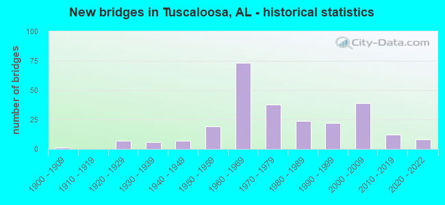
- New bridges - historical statistics
- 11900-1909
- 71920-1929
- 61930-1939
- 71940-1949
- 191950-1959
- 731960-1969
- 381970-1979
- 241980-1989
- 221990-1999
- 392000-2009
- 122010-2019
- 82020-2022
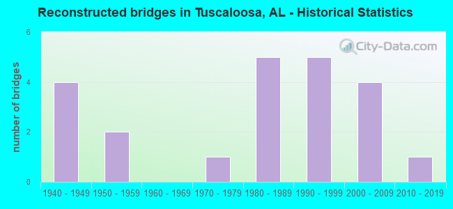
- Reconstructed bridges - Historical Statistics
- 41940-1949
- 21950-1959
- 01960-1969
- 11970-1979
- 51980-1989
- 51990-1999
- 42000-2009
- 12010-2019
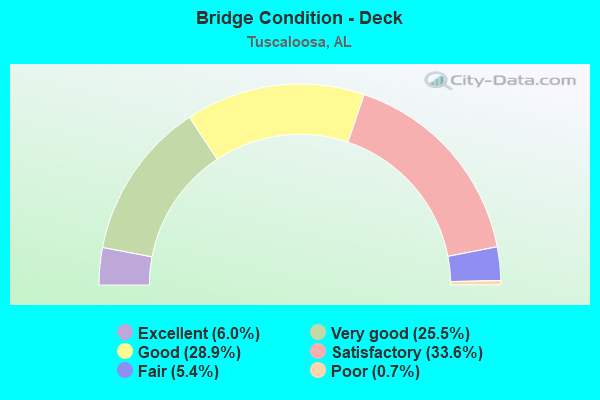
- Bridge Condition - Deck
- 6.0%Excellent
- 25.5%Very good
- 28.9%Good
- 33.6%Satisfactory
- 5.4%Fair
- 0.7%Poor
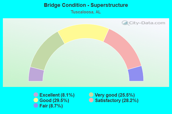
- Bridge Condition - Superstructure
- 8.1%Excellent
- 25.5%Very good
- 29.5%Good
- 28.2%Satisfactory
- 8.7%Fair
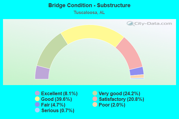
- Bridge Condition - Substructure
- 8.1%Excellent
- 24.2%Very good
- 39.6%Good
- 20.8%Satisfactory
- 4.7%Fair
- 2.0%Poor
- 0.7%Serious
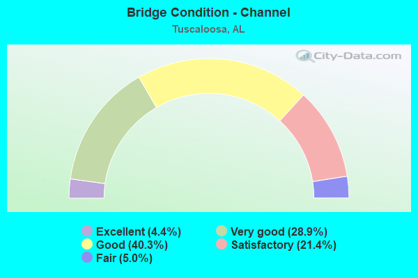
- Bridge Condition - Channel
- 4.4%Excellent
- 28.9%Very good
- 40.3%Good
- 21.4%Satisfactory
- 5.0%Fair
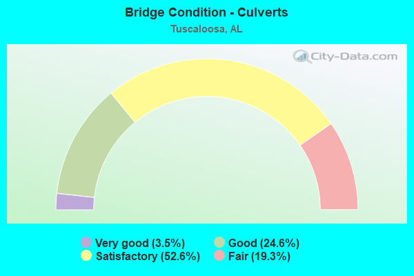
- Bridge Condition - Culverts
- 3.5%Very good
- 24.6%Good
- 52.6%Satisfactory
- 19.3%Fair
Find on map >> Show street view
Structure Number: 392, Location: .5 MI.N. OF BUTLER (Lat: 32.099639, Lng: -88.214661), Route carried "on" structure: State highway 17, Year Built: 1927, Status: Open, Structure Length: 0.68m (2.23ft), Average Daily Traffic: 3,330 (year 2013), Truck Traffic: 9%, Average Future Daily Traffic: 4,295 (year 2033), Design Load: H 15, Features Intersected: BRANCH
Minimum Vertical Clearance: 30+ m (98+ ft), Kilometerpoint: 176.365, Lanes on structure: 2, Owner: State Highway Agency, Approaching Roadway Width: 9.4m (30.8ft), Material/Design: Concrete, Design/Construction: Culvert, Number Of Spans In Main Unit: 2, Length of Maximum Span: 3.0m (9.8ft)
Condition: Channel: Fair, Culverts: Fair, Operating Rating: 74.3 metric tons, Method Used To Determine Operating Rating: Load Factor (LF), Inventory Rating: 44.5 metric tons, Method Used To Determine Inventory Rating: Load Factor (LF), Structural Evaluation: Somewhat better than minimum adequacy, Waterway Adequacy: Equal to present minimum criteria, Approach Roadway Alignment: Equal to present minimum criteria, Length Of Structure Improvement: 1.31m (4.30ft), Designated Inspection Frequency: Every 24 months, Inspection Date: November 2020, Bridge Improvement Cost: $530,000, Roadway Improvement Cost: $53,000, Total Project Cost: $583,000 ( Estimate for 2022)
Find on map >> Show street view
Structure Number: 514, Location: 0.6 MI S GA STATE LINE (Lat: 34.083417, Lng: -85.431522), Route carried "on" structure: US 411, Year Built: 1928, Status: Open, Structure Length: 1.40m (4.59ft), Average Daily Traffic: 3,523 (year 2019), Truck Traffic: 14%, Average Future Daily Traffic: 4,932 (year 2039), Features Intersected: SPRING CREEK
Minimum Vertical Clearance: 30+ m (98+ ft), Kilometerpoint: 413.296, Lanes on structure: 2, Owner: State Highway Agency, Approaching Roadway Width: 8.6m (28.2ft), Skew: 4 degrees, Material/Design: Concrete, Design/Construction: Culvert, Number Of Spans In Main Unit: 3, Length of Maximum Span: 3.0m (9.8ft)
Condition: Channel: Good, Culverts: Satisfactory, Operating Rating: 73.5 metric tons, Method Used To Determine Operating Rating: Load Factor (LF), Inventory Rating: 44.1 metric tons, Method Used To Determine Inventory Rating: Load Factor (LF), Structural Evaluation: Equal to present minimum criteria, Waterway Adequacy: Better than present minimum criteria, Approach Roadway Alignment: Equal to present desirable criteria, Length Of Structure Improvement: 2.07m (6.79ft), Designated Inspection Frequency: Every 24 months, Inspection Date: May 2021, Bridge Improvement Cost: $659,000, Roadway Improvement Cost: $66,000, Total Project Cost: $725,000 ( Estimate for 2022), Wearing Surface/Protective System: Wearing Surface: Bituminous
Find on map >> Show street view
Structure Number: 649, Location: K-MART PARKING LOT DRIVE (Lat: 33.164817, Lng: -87.547383), Route carried "on" structure: City street , Year Built: 1929, Status: Open, Structure Length: 0.94m (3.08ft), Average Daily Traffic: 2,808 (year 2001), Truck Traffic: 1%, Average Future Daily Traffic: 4,633 (year 2034), Design Load: H 15, Features Intersected: EDDIN CREEK, Facility Carried by Structure: STREET
Minimum Vertical Clearance: 30+ m (98+ ft), Kilometerpoint: 0.000, Lanes on structure: 2, Owner: City or Municipal Highway Agency, Approaching Roadway Width: 11.6m (38.1ft), Material/Design: Concrete, Design/Construction: Culvert, Number Of Spans In Main Unit: 3, Length of Maximum Span: 3.0m (9.8ft)
Condition: Channel: Good, Culverts: Satisfactory, Operating Rating: 42.1 metric tons, Method Used To Determine Operating Rating: Load Factor (LF), Inventory Rating: 25.2 metric tons, Method Used To Determine Inventory Rating: Load Factor (LF), Structural Evaluation: Equal to present minimum criteria, Waterway Adequacy: Equal to present minimum criteria, Approach Roadway Alignment: Equal to present minimum criteria, Length Of Structure Improvement: 1.61m (5.28ft), Designated Inspection Frequency: Every 24 months, Inspection Date: November 2020, Bridge Improvement Cost: $353,000, Roadway Improvement Cost: $35,000, Total Project Cost: $388,000 ( Estimate for 2022)
Find on map >> Show street view
Structure Number: 893, Location: 0.9 MI S EUTAW (Lat: 32.823283, Lng: -87.884817), Route carried "on" structure: US 43, Year Built: 1931, Status: Open, Structure Length: 0.73m (2.40ft), Average Daily Traffic: 4,540 (year 2013), Truck Traffic: 20%, Average Future Daily Traffic: 5,832 (year 2040), Design Load: H 15, Features Intersected: White Creek
Minimum Vertical Clearance: 30+ m (98+ ft), Kilometerpoint: 256.690, Lanes on structure: 2, Base Highway Network: Yes, Owner: State Highway Agency, Approaching Roadway Width: 10.1m (33.1ft), Skew: 3 degrees, Material/Design: Concrete, Design/Construction: Culvert, Number Of Spans In Main Unit: 2, Length of Maximum Span: 3.5m (11.5ft), Curb-To-Curb Width: 9.1m (29.9ft), Out-to-Out Width: 10.2m (33.5ft)
Condition: Channel: Satisfactory, Culverts: Satisfactory, Operating Rating: 48.4 metric tons, Method Used To Determine Operating Rating: Load Factor (LF), Inventory Rating: 32.7 metric tons, Method Used To Determine Inventory Rating: Load Factor (LF), Structural Evaluation: Equal to present minimum criteria, Deck Geometry: Meets minimum limits, Waterway Adequacy: Equal to present minimum criteria, Approach Roadway Alignment: Equal to present desirable criteria, Length Of Structure Improvement: 1.38m (4.53ft), Designated Inspection Frequency: Every 24 months, Inspection Date: June 2020, Bridge Improvement Cost: $294,000, Roadway Improvement Cost: $29,000, Total Project Cost: $323,000 ( Estimate for 2022)
Find on map >> Show street view
Structure Number: 898, Location: 3 MI S JCT SR 172 (Lat: 34.255583, Lng: -87.876722), Route carried "on" structure: US 43, Year Built: 1931, Status: Open, Structure Length: 1.01m (3.31ft), Average Daily Traffic: 2,910 (year 2020), Truck Traffic: 22%, Average Future Daily Traffic: 3,753 (year 2041), Design Load: H 15, Features Intersected: Clifty Creek, Facility Carried by Structure: AL-17
Minimum Vertical Clearance: 30+ m (98+ ft), Kilometerpoint: 464.233, Lanes on structure: 2, Base Highway Network: Yes, Owner: State Highway Agency, Approaching Roadway Width: 7.9m (25.9ft), Material/Design: Concrete, Design/Construction: Culvert, Number Of Spans In Main Unit: 3, Length of Maximum Span: 3.0m (9.8ft)
Condition: Channel: Satisfactory, Culverts: Satisfactory, Operating Rating: 88.9 metric tons, Method Used To Determine Operating Rating: Load Factor (LF), Inventory Rating: 88.9 metric tons, Method Used To Determine Inventory Rating: Load Factor (LF), Structural Evaluation: Equal to present minimum criteria, Waterway Adequacy: Equal to present desirable criteria, Approach Roadway Alignment: Equal to present minimum criteria, Length Of Structure Improvement: 1.68m (5.51ft), Designated Inspection Frequency: Every 24 months, Inspection Date: Febuary 2021, Bridge Improvement Cost: $835,000, Roadway Improvement Cost: $84,000, Total Project Cost: $919,000 ( Estimate for 2022)
Find on map >> Show street view
Structure Number: 1016, Location: 0.5 MI W CO RT 399 (Lat: 33.512542, Lng: -86.021747), Route carried "on" structure: County highway 400, Year Built: 1932, Status: Posted for load, Structure Length: 3.90m (12.80ft), Average Daily Traffic: 375 (year 2018), Average Future Daily Traffic: 1,840 (year 2038), Features Intersected: KELLEY CREEK
Minimum Vertical Clearance: 30+ m (98+ ft), Kilometerpoint: 0.010, Lanes on structure: 1, Owner: County Highway Agency, Approaching Roadway Width: 6.1m (20.0ft), Material/Design: Steel, Design/Construction: Stringer/Multi-beam, Number Of Spans In Main Unit: 7, Length of Maximum Span: 15.2m (49.9ft), Curb-To-Curb Width: 4.7m (15.4ft), Out-to-Out Width: 4.9m (16.1ft)
Condition: Deck: Satisfactory, Superstructure: Satisfactory, Substructure: Satisfactory, Channel: Good, Operating Rating: 22.1 metric tons, Method Used To Determine Operating Rating: Allowable Stress (AS), Inventory Rating: 14.4 metric tons, Method Used To Determine Inventory Rating: Allowable Stress (AS), Structural Evaluation: Meets minimum limits, Deck Geometry: High priority of replacement, Waterway Adequacy: Better than present minimum criteria, Approach Roadway Alignment: Equal to present minimum criteria, Bridge Posting: Required (Relationship of Operating Rating to Maximum Legal Load: > 39.9% below), Length Of Structure Improvement: 4.85m (15.91ft), Designated Inspection Frequency: Every 24 months, Other Special Inspection Frequency: Every 12 months, Inspection Date: August 2020, Other Special Inspection Date: August 2021, Bridge Improvement Cost: $532,000, Roadway Improvement Cost: $53,000, Total Project Cost: $585,000 ( Estimate for 2022), Deck Structure Type: Wood or Timber, Wearing Surface/Protective System: Wearing Surface: Wood or Timber
Find on map >> Show street view
Structure Number: 1017, Location: 0.2 MI NE OF JCT US NO 11 (Lat: 33.154747, Lng: -87.634442), Route carried "on" structure: County highway 504, Year Built: 1932, Status: Open, Structure Length: 2.80m (9.19ft), Average Daily Traffic: 20 (year 1996), Average Future Daily Traffic: 50 (year 2035), Design Load: H 15, Features Intersected: SLOUGH, Facility Carried by Structure: OLD US NO 11
Minimum Vertical Clearance: 30+ m (98+ ft), Kilometerpoint: 0.010, Lanes on structure: 2, Owner: County Highway Agency, Approaching Roadway Width: 7.9m (25.9ft), Material/Design: Concrete, Design/Construction: Tee Beam, Number Of Spans In Main Unit: 3, Length of Maximum Span: 9.4m (30.8ft), Curb-To-Curb Width: 6.7m (22.0ft), Out-to-Out Width: 7.6m (24.9ft)
Condition: Deck: Fair, Superstructure: Satisfactory, Substructure: Satisfactory, Channel: Good, Operating Rating: 45.7 metric tons, Method Used To Determine Operating Rating: Load Factor (LF), Inventory Rating: 27.4 metric tons, Method Used To Determine Inventory Rating: Load Factor (LF), Structural Evaluation: Equal to present minimum criteria, Deck Geometry: Somewhat better than minimum adequacy, Waterway Adequacy: Equal to present desirable criteria, Approach Roadway Alignment: Superior to present desirable criteria, Length Of Structure Improvement: 3.73m (12.24ft), Designated Inspection Frequency: Every 24 months, Inspection Date: July 2021, Bridge Improvement Cost: $639,000, Roadway Improvement Cost: $64,000, Total Project Cost: $703,000 ( Estimate for 2022), Deck Structure Type: Concrete Cast-file-Place
Find on map >> Show street view
Structure Number: 2135, Location: 1.5 MI N ROBINSONVILLE (Lat: 31.089289, Lng: -87.430836), Route carried "on" structure: ServiceCounty highway 50, Year Built: 1940, Status: Posted for load, Structure Length: 0.91m (2.99ft), Average Daily Traffic: 65 (year 1988), Average Future Daily Traffic: 95 (year 2034), Design Load: H 10, Features Intersected: SIZEMORE CREEK, Facility Carried by Structure: COUNTY ROAD
Minimum Vertical Clearance: 30+ m (98+ ft), Kilometerpoint: 0.010, Lanes on structure: 1, Owner: County Highway Agency, Approaching Roadway Width: 6.1m (20.0ft), Material/Design: Wood or Timber, Design/Construction: Stringer/Multi-beam, Number Of Spans In Main Unit: 2, Length of Maximum Span: 4.6m (15.1ft), Curb-To-Curb Width: 4.9m (16.1ft), Out-to-Out Width: 4.9m (16.1ft)
Condition: Deck: Fair, Superstructure: Fair, Substructure: Serious, Channel: Fair, Operating Rating: 2.7 metric tons, Method Used To Determine Operating Rating: Allowable Stress (AS), Inventory Rating: 1.8 metric tons, Method Used To Determine Inventory Rating: Allowable Stress (AS), Structural Evaluation: High priority of replacement, Deck Geometry: High priority of corrective action, Waterway Adequacy: Meets minimum limits, Approach Roadway Alignment: High priority of corrective action, Bridge Posting: Required (Relationship of Operating Rating to Maximum Legal Load: > 39.9% below), Length Of Structure Improvement: 1.58m (5.18ft), Designated Inspection Frequency: Every 24 months, Other Special Inspection Frequency: Every 3 months, Inspection Date: December 2020, Other Special Inspection Date: December 2021, Bridge Improvement Cost: $173,000, Roadway Improvement Cost: $17,000, Total Project Cost: $190,000 ( Estimate for 2019), Deck Structure Type: Wood or Timber, Wearing Surface/Protective System: Wearing Surface: Wood or Timber
Find on map >> Show street view
Structure Number: 2537, Location: 2.5 MI N WARRIOR RIVER (Lat: 33.147200, Lng: -87.637886), Route carried "on" structure: US 11, Year Built: 1941, Status: Open, Structure Length: 9.07m (29.76ft), Average Daily Traffic: 3,500 (year 2016), Truck Traffic: 16%, Average Future Daily Traffic: 4,586 (year 2036), Design Load: H 20, Features Intersected: WARRIOR RIVER RELIEF
Minimum Vertical Clearance: 30+ m (98+ ft), Kilometerpoint: 115.099, Lanes on structure: 2, Owner: State Highway Agency, Approaching Roadway Width: 7.3m (24.0ft), Material/Design: Concrete continuous, Design/Construction: Slab, Number Of Spans In Main Unit: 16, Length of Maximum Span: 6.1m (20.0ft), Curb or Sidewalk Widths: Left: 0.5m (1.6ft), Right: 0.5m (1.6ft), Curb-To-Curb Width: 7.3m (24.0ft), Out-to-Out Width: 8.9m (29.2ft)
Condition: Deck: Satisfactory, Superstructure: Satisfactory, Substructure: Satisfactory, Channel: Very good, Operating Rating: 53.8 metric tons, Method Used To Determine Operating Rating: Load Factor (LF), Inventory Rating: 32.2 metric tons, Method Used To Determine Inventory Rating: Load Factor (LF), Structural Evaluation: Equal to present minimum criteria, Deck Geometry: High priority of replacement, Waterway Adequacy: Equal to present minimum criteria, Approach Roadway Alignment: Equal to present desirable criteria, Length Of Structure Improvement: 10.04m (32.94ft), Designated Inspection Frequency: Every 24 months, Inspection Date: August 2020, Bridge Improvement Cost: $1,996,000, Roadway Improvement Cost: $200,000, Total Project Cost: $2,196,000 ( Estimate for 2022), Deck Structure Type: Concrete Cast-file-Place
Find on map >> Show street view
Structure Number: 2538, Location: 3.3 MI N WARRIOR RIVER (Lat: 33.156928, Lng: -87.630261), Route carried "on" structure: US 11, Year Built: 1941, Status: Open, Structure Length: 2.85m (9.35ft), Average Daily Traffic: 3,700 (year 2016), Truck Traffic: 5%, Average Future Daily Traffic: 4,848 (year 2038), Design Load: H 20, Features Intersected: WARRIOR RIVER RELIEF
Minimum Vertical Clearance: 30+ m (98+ ft), Kilometerpoint: 116.415, Lanes on structure: 2, Owner: State Highway Agency, Approaching Roadway Width: 9.4m (30.8ft), Material/Design: Concrete continuous, Design/Construction: Slab, Number Of Spans In Main Unit: 5, Length of Maximum Span: 6.1m (20.0ft), Curb or Sidewalk Widths: Left: 0.5m (1.6ft), Right: 0.5m (1.6ft), Curb-To-Curb Width: 7.2m (23.6ft), Out-to-Out Width: 8.9m (29.2ft)
Condition: Deck: Satisfactory, Superstructure: Satisfactory, Substructure: Good, Channel: Very good, Operating Rating: 54.1 metric tons, Method Used To Determine Operating Rating: Load Factor (LF), Inventory Rating: 32.4 metric tons, Method Used To Determine Inventory Rating: Load Factor (LF), Structural Evaluation: Equal to present minimum criteria, Deck Geometry: High priority of replacement, Waterway Adequacy: Equal to present minimum criteria, Approach Roadway Alignment: Equal to present desirable criteria, Length Of Structure Improvement: 3.77m (12.37ft), Designated Inspection Frequency: Every 24 months, Inspection Date: July 2020, Bridge Improvement Cost: $750,000, Roadway Improvement Cost: $75,000, Total Project Cost: $825,000 ( Estimate for 2022), Deck Structure Type: Concrete Cast-file-Place
Find on map >> Show street view
Structure Number: 2814, Location: 0.5 MI N JCT SR 215 (Lat: 33.190458, Lng: -87.440031), Route carried "on" structure: US 11, Year Built: 1945, Status: Open, Structure Length: 1.65m (5.41ft), Average Daily Traffic: 9,520 (year 2016), Truck Traffic: 8%, Average Future Daily Traffic: 12,473 (year 2040), Design Load: H 20, Features Intersected: Cottondale Creek
Minimum Vertical Clearance: 30+ m (98+ ft), Kilometerpoint: 140.126, Lanes on structure: 2, Owner: State Highway Agency, Approaching Roadway Width: 10.4m (34.1ft), Skew: 3 degrees, Material/Design: Concrete, Design/Construction: Culvert, Number Of Spans In Main Unit: 3, Length of Maximum Span: 5.3m (17.4ft)
Condition: Channel: Satisfactory, Culverts: Satisfactory, Operating Rating: 41.8 metric tons, Method Used To Determine Operating Rating: Load Factor (LF), Inventory Rating: 25.0 metric tons, Method Used To Determine Inventory Rating: Load Factor (LF), Structural Evaluation: Equal to present minimum criteria, Waterway Adequacy: Equal to present minimum criteria, Approach Roadway Alignment: Equal to present desirable criteria, Length Of Structure Improvement: 2.33m (7.64ft), Designated Inspection Frequency: Every 24 months, Inspection Date: May 2020, Bridge Improvement Cost: $688,000, Roadway Improvement Cost: $69,000, Total Project Cost: $757,000 ( Estimate for 2022)
Find on map >> Show street view
Structure Number: 2818, Location: 4.5 MI S BIBB CO LINE (Lat: 33.173597, Lng: -87.264831), Route carried "on" structure: US 11, Year Built: 1945, Year Reconstructed: 1998, Status: Open, Structure Length: 0.98m (3.22ft), Average Daily Traffic: 6,450 (year 2016), Truck Traffic: 9%, Average Future Daily Traffic: 8,451 (year 2040), Design Load: H 15, Features Intersected: Little Hurricane Creek
Minimum Vertical Clearance: 30+ m (98+ ft), Kilometerpoint: 158.089, Lanes on structure: 2, Owner: State Highway Agency, Approaching Roadway Width: 16.0m (52.5ft), Skew: 1 degrees, Material/Design: Concrete, Design/Construction: Culvert, Number Of Spans In Main Unit: 3, Length of Maximum Span: 3.2m (10.5ft)
Condition: Channel: Satisfactory, Culverts: Satisfactory, Operating Rating: 88.9 metric tons, Method Used To Determine Operating Rating: Load Factor (LF), Inventory Rating: 53.4 metric tons, Method Used To Determine Inventory Rating: Load Factor (LF), Structural Evaluation: Equal to present minimum criteria, Waterway Adequacy: Equal to present minimum criteria, Approach Roadway Alignment: Equal to present minimum criteria, Length Of Structure Improvement: 1.64m (5.38ft), Designated Inspection Frequency: Every 24 months, Inspection Date: June 2020, Bridge Improvement Cost: $1,234,000, Roadway Improvement Cost: $123,000, Total Project Cost: $1,357,000 ( Estimate for 2022)
Find on map >> Show street view
Structure Number: 2885, Location: 0.8 MI E. WARRIOR RIVER (Lat: 33.126339, Lng: -87.656333), Route carried "on" structure: US 11, Year Built: 1927, Year Reconstructed: 1946, Status: Open, Structure Length: 4.65m (15.26ft), Average Daily Traffic: 3,500 (year 2013), Truck Traffic: 16%, Average Future Daily Traffic: 4,586 (year 2033), Design Load: H 15, Features Intersected: WARRIOR RIVER RELIEF
Minimum Vertical Clearance: 30+ m (98+ ft), Kilometerpoint: 112.194, Lanes on structure: 2, Owner: State Highway Agency, Approaching Roadway Width: 9.8m (32.2ft), Material/Design: Concrete, Design/Construction: Tee Beam, Number Of Spans In Main Unit: 5, Length of Maximum Span: 9.3m (30.5ft), Curb or Sidewalk Widths: Left: 0.5m (1.6ft), Right: 0.5m (1.6ft), Curb-To-Curb Width: 7.9m (25.9ft), Out-to-Out Width: 9.5m (31.2ft)
Condition: Deck: Good, Superstructure: Satisfactory, Substructure: Satisfactory, Channel: Good, Operating Rating: 47.1 metric tons, Method Used To Determine Operating Rating: Load Factor (LF), Inventory Rating: 28.2 metric tons, Method Used To Determine Inventory Rating: Load Factor (LF), Structural Evaluation: Equal to present minimum criteria, Deck Geometry: High priority of corrective action, Waterway Adequacy: Equal to present desirable criteria, Approach Roadway Alignment: Equal to present desirable criteria, Length Of Structure Improvement: 5.65m (18.54ft), Designated Inspection Frequency: Every 24 months, Inspection Date: August 2020, Bridge Improvement Cost: $1,201,000, Roadway Improvement Cost: $120,000, Total Project Cost: $1,321,000 ( Estimate for 2022), Deck Structure Type: Concrete Cast-file-Place, Wearing Surface/Protective System: Wearing Surface: Bituminous
Find on map >> Show street view
Structure Number: 2886, Location: 1.0 MI N WARRIOR RIVER (Lat: 33.129881, Lng: -87.654375), Route carried "on" structure: US 11, Year Built: 1927, Year Reconstructed: 1946, Status: Open, Structure Length: 2.79m (9.15ft), Average Daily Traffic: 3,500 (year 2016), Truck Traffic: 16%, Average Future Daily Traffic: 4,586 (year 2038), Design Load: H 15, Features Intersected: WARRIOR RIVER RELIEF
Minimum Vertical Clearance: 30+ m (98+ ft), Kilometerpoint: 112.627, Lanes on structure: 2, Owner: State Highway Agency, Approaching Roadway Width: 7.5m (24.6ft), Material/Design: Concrete, Design/Construction: Tee Beam, Number Of Spans In Main Unit: 3, Length of Maximum Span: 9.3m (30.5ft), Curb or Sidewalk Widths: Left: 0.5m (1.6ft), Right: 0.5m (1.6ft), Curb-To-Curb Width: 7.9m (25.9ft), Out-to-Out Width: 9.1m (29.9ft)
Condition: Deck: Satisfactory, Superstructure: Fair, Substructure: Fair, Channel: Very good, Operating Rating: 47.1 metric tons, Method Used To Determine Operating Rating: Load Factor (LF), Inventory Rating: 28.2 metric tons, Method Used To Determine Inventory Rating: Load Factor (LF), Structural Evaluation: Somewhat better than minimum adequacy, Deck Geometry: High priority of corrective action, Waterway Adequacy: Equal to present minimum criteria, Approach Roadway Alignment: Better than present minimum criteria, Length Of Structure Improvement: 3.71m (12.17ft), Designated Inspection Frequency: Every 24 months, Inspection Date: May 2020, Bridge Improvement Cost: $738,000, Roadway Improvement Cost: $74,000, Total Project Cost: $812,000 ( Estimate for 2022), Deck Structure Type: Concrete Cast-file-Place, Wearing Surface/Protective System: Wearing Surface: Bituminous
Find on map >> Show street view
Structure Number: 2887, Location: 1.7 MI E. WARRIOR RIVER (Lat: 33.137908, Lng: -87.646808), Route carried "on" structure: US 11, Year Built: 1927, Year Reconstructed: 1946, Status: Open, Structure Length: 2.79m (9.15ft), Average Daily Traffic: 3,500 (year 2013), Truck Traffic: 16%, Average Future Daily Traffic: 4,586 (year 2033), Design Load: H 15, Features Intersected: WARRIOR RIVER RELIEF
Minimum Vertical Clearance: 30+ m (98+ ft), Kilometerpoint: 113.782, Lanes on structure: 2, Owner: State Highway Agency, Approaching Roadway Width: 9.8m (32.2ft), Material/Design: Concrete, Design/Construction: Tee Beam, Number Of Spans In Main Unit: 3, Length of Maximum Span: 9.3m (30.5ft), Curb or Sidewalk Widths: Left: 0.5m (1.6ft), Right: 0.5m (1.6ft), Curb-To-Curb Width: 7.9m (25.9ft), Out-to-Out Width: 9.5m (31.2ft)
Condition: Deck: Satisfactory, Superstructure: Fair, Substructure: Good, Channel: Good, Operating Rating: 47.1 metric tons, Method Used To Determine Operating Rating: Load Factor (LF), Inventory Rating: 28.2 metric tons, Method Used To Determine Inventory Rating: Load Factor (LF), Structural Evaluation: Somewhat better than minimum adequacy, Deck Geometry: High priority of corrective action, Waterway Adequacy: Equal to present desirable criteria, Approach Roadway Alignment: Somewhat better than minimum adequacy, Length Of Structure Improvement: 3.71m (12.17ft), Designated Inspection Frequency: Every 24 months, Underwater Inspection Frequency: Every 24 months, Inspection Date: August 2020, Underwater Inspection Date: July 2020, Bridge Improvement Cost: $788,000, Roadway Improvement Cost: $79,000, Total Project Cost: $867,000 ( Estimate for 2022), Deck Structure Type: Concrete Cast-file-Place, Wearing Surface/Protective System: Wearing Surface: Bituminous
Find on map >> Show street view
Structure Number: 2888, Location: 4.1 MI N WARRIOR RIVER (Lat: 33.166500, Lng: -87.622700), Route carried "on" structure: US 11, Year Built: 1927, Year Reconstructed: 1946, Status: Open, Structure Length: 2.79m (9.15ft), Average Daily Traffic: 3,890 (year 2013), Truck Traffic: 16%, Average Future Daily Traffic: 5,097 (year 2033), Design Load: H 15, Features Intersected: WARRIOR RIVER RELIEF
Minimum Vertical Clearance: 30+ m (98+ ft), Kilometerpoint: 117.649, Lanes on structure: 2, Owner: State Highway Agency, Approaching Roadway Width: 9.4m (30.8ft), Material/Design: Concrete, Design/Construction: Tee Beam, Number Of Spans In Main Unit: 3, Length of Maximum Span: 9.3m (30.5ft), Curb or Sidewalk Widths: Left: 0.5m (1.6ft), Right: 0.5m (1.6ft), Curb-To-Curb Width: 7.9m (25.9ft), Out-to-Out Width: 9.5m (31.2ft)
Condition: Deck: Satisfactory, Superstructure: Satisfactory, Substructure: Satisfactory, Channel: Good, Operating Rating: 47.1 metric tons, Method Used To Determine Operating Rating: Load Factor (LF), Inventory Rating: 28.2 metric tons, Method Used To Determine Inventory Rating: Load Factor (LF), Structural Evaluation: Equal to present minimum criteria, Deck Geometry: High priority of corrective action, Waterway Adequacy: Equal to present minimum criteria, Approach Roadway Alignment: Equal to present desirable criteria, Length Of Structure Improvement: 3.71m (12.17ft), Designated Inspection Frequency: Every 24 months, Underwater Inspection Frequency: Every 24 months, Inspection Date: October 2020, Underwater Inspection Date: July 2020, Bridge Improvement Cost: $788,000, Roadway Improvement Cost: $79,000, Total Project Cost: $867,000 ( Estimate for 2022), Deck Structure Type: Concrete Cast-file-Place, Wearing Surface/Protective System: Wearing Surface: Bituminous
Find on map >> Show street view
Structure Number: 3139, Location: 3.5 MI E JCT USNO 43 (Lat: 33.492811, Lng: -87.562639), Route carried "on" structure: County highway 160, Year Built: 1947, Status: Open, Structure Length: 1.52m (4.99ft), Average Daily Traffic: 300 (year 1997), Truck Traffic: 20%, Average Future Daily Traffic: 400 (year 2034), Design Load: HS 20, Features Intersected: CRIPPLE CREEK, Facility Carried by Structure: NORTHSIDE ROAD
Minimum Vertical Clearance: 30+ m (98+ ft), Kilometerpoint: 0.010, Lanes on structure: 2, Owner: County Highway Agency, Approaching Roadway Width: 9.1m (29.9ft), Material/Design: Concrete, Design/Construction: Culvert, Number Of Spans In Main Unit: 3, Length of Maximum Span: 4.6m (15.1ft)
Condition: Channel: Good, Culverts: Good, Operating Rating: 82.1 metric tons, Method Used To Determine Operating Rating: Load Factor (LF), Inventory Rating: 49.3 metric tons, Method Used To Determine Inventory Rating: Load Factor (LF), Structural Evaluation: Better than present minimum criteria, Waterway Adequacy: Superior to present desirable criteria, Approach Roadway Alignment: Equal to present desirable criteria, Length Of Structure Improvement: 2.20m (7.22ft), Designated Inspection Frequency: Every 24 months, Inspection Date: December 2020, Bridge Improvement Cost: $764,000, Roadway Improvement Cost: $76,000, Total Project Cost: $840,000 ( Estimate for 2022), Wearing Surface/Protective System: Wearing Surface: Bituminous
Find on map >> Show street view
Structure Number: 3357, Location: 2.4 MI E OF JCT US NO 43 (Lat: 33.479792, Lng: -87.596792), Route carried "on" structure: County highway 160, Year Built: 1948, Status: Posted for load, Structure Length: 9.27m (30.41ft), Average Daily Traffic: 650 (year 1996), Truck Traffic: 10%, Average Future Daily Traffic: 750 (year 2036), Design Load: H 15, Features Intersected: NORTH RIVER, Facility Carried by Structure: NORTHSIDE ROAD
Minimum Vertical Clearance: 30+ m (98+ ft), Kilometerpoint: 0.010, Lanes on structure: 2, Owner: County Highway Agency, Approaching Roadway Width: 8.5m (27.9ft), Material/Design: Steel continuous, Design/Construction: Stringer/Multi-beam, Number Of Spans In Main Unit: 3, Number Of Approach Spans: 3, Length of Maximum Span: 24.4m (80.1ft), Curb-To-Curb Width: 6.7m (22.0ft), Out-to-Out Width: 7.3m (24.0ft)
Condition: Deck: Satisfactory, Superstructure: Good, Substructure: Good, Channel: Good, Operating Rating: 29.3 metric tons, Method Used To Determine Operating Rating: Load Factor (LF), Inventory Rating: 17.6 metric tons, Method Used To Determine Inventory Rating: Load Factor (LF), Structural Evaluation: Meets minimum limits, Deck Geometry: Meets minimum limits, Waterway Adequacy: Superior to present desirable criteria, Approach Roadway Alignment: Better than present minimum criteria, Bridge Posting: Required (Relationship of Operating Rating to Maximum Legal Load: 20.0 - 29.9% below), Length Of Structure Improvement: 10.23m (33.56ft), Designated Inspection Frequency: Every 24 months, Other Special Inspection Frequency: Every 12 months, Inspection Date: April 2020, Other Special Inspection Date: April 2021, Bridge Improvement Cost: $1,683,000, Roadway Improvement Cost: $168,000, Total Project Cost: $1,851,000 ( Estimate for 2022), Deck Structure Type: Concrete Cast-file-Place
Find on map >> Show street view
Structure Number: 3705, Location: 0.3 MI W I-59 (Lat: 33.181383, Lng: -87.508933), Route carried "on" structure: County highway 37, Year Built: 1950, Year Reconstructed: 1998, Status: Open, Structure Length: 0.94m (3.08ft), Average Daily Traffic: 18,336 (year 2007), Truck Traffic: 1%, Average Future Daily Traffic: 30,254 (year 2034), Design Load: H 15, Features Intersected: Trib. to Cribbs Mill Ck.
Minimum Vertical Clearance: 30+ m (98+ ft), Kilometerpoint: 0.000, Lanes on structure: 2, Owner: City or Municipal Highway Agency, Approaching Roadway Width: 8.5m (27.9ft), Skew: 4 degrees, Material/Design: Concrete, Design/Construction: Culvert, Number Of Spans In Main Unit: 2, Length of Maximum Span: 3.0m (9.8ft), Curb-To-Curb Width: 8.5m (27.9ft), Out-to-Out Width: 9.4m (30.8ft)
Condition: Channel: Good, Culverts: Satisfactory, Operating Rating: 42.5 metric tons, Method Used To Determine Operating Rating: Load Factor (LF), Inventory Rating: 25.5 metric tons, Method Used To Determine Inventory Rating: Load Factor (LF), Structural Evaluation: Equal to present minimum criteria, Deck Geometry: High priority of replacement, Approach Roadway Alignment: Equal to present desirable criteria, Length Of Structure Improvement: 1.61m (5.28ft), Designated Inspection Frequency: Every 24 months, Inspection Date: November 2020, Bridge Improvement Cost: $501,000, Roadway Improvement Cost: $50,000, Total Project Cost: $551,000 ( Estimate for 2022)
Find on map >> Show street view
Structure Number: 3716, Location: 0.1 MI W LAKE AVE (Lat: 33.193361, Lng: -87.535139), Route carried "on" structure: City street , Year Built: 1950, Status: Open, Structure Length: 1.04m (3.41ft), Average Daily Traffic: 1,807 (year 2001), Truck Traffic: 1%, Average Future Daily Traffic: 4,990 (year 2030), Design Load: H 20, Features Intersected: Forest Lake Branch, Facility Carried by Structure: 19TH STREET E
Minimum Vertical Clearance: 30+ m (98+ ft), Kilometerpoint: 0.000, Lanes on structure: 2, Owner: City or Municipal Highway Agency, Approaching Roadway Width: 8.5m (27.9ft), Material/Design: Concrete, Design/Construction: Channel Beam, Number Of Spans In Main Unit: 1, Length of Maximum Span: 10.4m (34.1ft), Curb or Sidewalk Widths: Left: 1.2m (3.9ft), Right: 1.2m (3.9ft), Curb-To-Curb Width: 8.7m (28.5ft), Out-to-Out Width: 11.5m (37.7ft)
Condition: Deck: Good, Superstructure: Satisfactory, Substructure: Satisfactory, Channel: Good, Operating Rating: 46.4 metric tons, Method Used To Determine Operating Rating: Load Factor (LF), Inventory Rating: 27.9 metric tons, Method Used To Determine Inventory Rating: Load Factor (LF), Structural Evaluation: Equal to present minimum criteria, Deck Geometry: Somewhat better than minimum adequacy, Waterway Adequacy: Equal to present desirable criteria, Approach Roadway Alignment: Better than present minimum criteria, Length Of Structure Improvement: 1.71m (5.61ft), Designated Inspection Frequency: Every 24 months, Inspection Date: November 2021, Bridge Improvement Cost: $435,000, Roadway Improvement Cost: $44,000, Total Project Cost: $479,000 ( Estimate for 2022), Deck Structure Type: Concrete Precast Panels, Wearing Surface/Protective System: Wearing Surface: Bituminous
Find on map >> Show street view
Structure Number: 392, Location: ON DAM OF LAKE NICOL ROAD (Lat: 33.289750, Lng: -87.484367), Route carried "on" structure: County highway 260, Year Built: 1950, Status: Posted for load, Structure Length: 1.25m (4.10ft), Average Daily Traffic: 250 (year 1997), Truck Traffic: 5%, Average Future Daily Traffic: 350 (year 2034), Design Load: HS 20, Features Intersected: LAKE NICOL SPILLWAY
Minimum Vertical Clearance: 30+ m (98+ ft), Kilometerpoint: 0.010, Lanes on structure: 2, Owner: City or Municipal Highway Agency, Approaching Roadway Width: 7.9m (25.9ft), Material/Design: Concrete, Design/Construction: Tee Beam, Number Of Spans In Main Unit: 1, Length of Maximum Span: 12.5m (41.0ft), Curb or Sidewalk Widths: Left: 0.9m (3.0ft), Right: 0.9m (3.0ft), Curb-To-Curb Width: 7.3m (24.0ft), Out-to-Out Width: 9.8m (32.2ft)
Condition: Deck: Fair, Superstructure: Fair, Substructure: Satisfactory, Channel: Very good, Operating Rating: 27.2 metric tons, Method Used To Determine Operating Rating: Field evaluation and documented engineering judgment, Inventory Rating: 20.0 metric tons, Method Used To Determine Inventory Rating: Field evaluation and documented engineering judgment, Structural Evaluation: Somewhat better than minimum adequacy, Deck Geometry: Somewhat better than minimum adequacy, Waterway Adequacy: Superior to present desirable criteria, Approach Roadway Alignment: Better than present minimum criteria, Bridge Posting: Required (Relationship of Operating Rating to Maximum Legal Load: 20.0 - 29.9% below), Length Of Structure Improvement: 1.92m (6.30ft), Designated Inspection Frequency: Every 24 months, Other Special Inspection Frequency: Every 12 months, Inspection Date: November 2020, Other Special Inspection Date: November 2021, Bridge Improvement Cost: $422,000, Roadway Improvement Cost: $42,000, Total Project Cost: $464,000 ( Estimate for 2019), Deck Structure Type: Concrete Cast-file-Place
Find on map >> Show street view
Structure Number: 4169, Location: 1.3 MI N OF JCT US NO 43 (Lat: 33.467117, Lng: -87.607872), Route carried "on" structure: County highway 216, Year Built: 1951, Status: Open, Structure Length: 0.94m (3.08ft), Average Daily Traffic: 345 (year 1996), Truck Traffic: 20%, Average Future Daily Traffic: 450 (year 2034), Design Load: HS 20, Features Intersected: PATTY'S CREEK, Facility Carried by Structure: GORGAS ROAD
Minimum Vertical Clearance: 30+ m (98+ ft), Kilometerpoint: 0.010, Lanes on structure: 2, Owner: County Highway Agency, Approaching Roadway Width: 8.5m (27.9ft), Material/Design: Concrete, Design/Construction: Culvert, Number Of Spans In Main Unit: 3, Length of Maximum Span: 3.0m (9.8ft)
Condition: Channel: Good, Culverts: Good, Operating Rating: 60.6 metric tons, Method Used To Determine Operating Rating: Load Factor (LF), Inventory Rating: 36.3 metric tons, Method Used To Determine Inventory Rating: Load Factor (LF), Structural Evaluation: Better than present minimum criteria, Waterway Adequacy: Equal to present desirable criteria, Approach Roadway Alignment: Better than present minimum criteria, Length Of Structure Improvement: 1.62m (5.31ft), Designated Inspection Frequency: Every 24 months, Inspection Date: December 2020, Bridge Improvement Cost: $290,000, Roadway Improvement Cost: $29,000, Total Project Cost: $319,000 ( Estimate for 2022), Wearing Surface/Protective System: Wearing Surface: Bituminous
Find on map >> Show street view
Structure Number: 417, Location: 3.1 MI N OF JCT US NO 43 (Lat: 33.491353, Lng: -87.602161), Route carried "on" structure: County highway 216, Year Built: 1951, Status: Open, Structure Length: 0.76m (2.49ft), Average Daily Traffic: 400 (year 1996), Truck Traffic: 20%, Average Future Daily Traffic: 500 (year 2038), Design Load: HS 20, Features Intersected: BRANCH, Facility Carried by Structure: OLD JASPER ROAD
Minimum Vertical Clearance: 30+ m (98+ ft), Kilometerpoint: 0.010, Lanes on structure: 2, Owner: County Highway Agency, Approaching Roadway Width: 8.5m (27.9ft), Material/Design: Concrete, Design/Construction: Culvert, Number Of Spans In Main Unit: 2, Length of Maximum Span: 3.7m (12.1ft)
Condition: Channel: Good, Culverts: Good, Operating Rating: 38.7 metric tons, Method Used To Determine Operating Rating: Load Factor (LF), Inventory Rating: 23.2 metric tons, Method Used To Determine Inventory Rating: Load Factor (LF), Structural Evaluation: Equal to present minimum criteria, Waterway Adequacy: Equal to present desirable criteria, Approach Roadway Alignment: Better than present minimum criteria, Length Of Structure Improvement: 1.41m (4.63ft), Designated Inspection Frequency: Every 24 months, Inspection Date: December 2020, Bridge Improvement Cost: $343,000, Roadway Improvement Cost: $34,000, Total Project Cost: $377,000 ( Estimate for 2022), Wearing Surface/Protective System: Wearing Surface: Bituminous
Find on map >> Show street view
Structure Number: 4873, Location: 0.5 MI SE OF JCT US # 82 (Lat: 33.227867, Lng: -87.622633), Route carried "on" structure: County highway 37, Year Built: 1954, Status: Open, Structure Length: 0.64m (2.10ft), Average Daily Traffic: 250 (year 1997), Truck Traffic: 5%, Average Future Daily Traffic: 300 (year 2034), Design Load: HS 20, Features Intersected: TATER HILL CREEK, Facility Carried by Structure: OLD COLUMBUS ROA
Minimum Vertical Clearance: 30+ m (98+ ft), Kilometerpoint: 0.010, Lanes on structure: 2, Owner: City or Municipal Highway Agency, Approaching Roadway Width: 8.5m (27.9ft), Material/Design: Concrete, Design/Construction: Culvert, Number Of Spans In Main Unit: 2, Length of Maximum Span: 3.0m (9.8ft)
Condition: Channel: Satisfactory, Culverts: Fair, Operating Rating: 66.4 metric tons, Method Used To Determine Operating Rating: Load Factor (LF), Inventory Rating: 39.8 metric tons, Method Used To Determine Inventory Rating: Load Factor (LF), Structural Evaluation: Somewhat better than minimum adequacy, Waterway Adequacy: Equal to present desirable criteria, Approach Roadway Alignment: Better than present minimum criteria, Length Of Structure Improvement: 1.26m (4.13ft), Designated Inspection Frequency: Every 24 months, Inspection Date: November 2020, Bridge Improvement Cost: $277,000, Roadway Improvement Cost: $28,000, Total Project Cost: $305,000 ( Estimate for 2022), Wearing Surface/Protective System: Wearing Surface: Bituminous
Find on map >> Show street view
Structure Number: 4983, Location: 4.3 MI NE OF JCT ALA N 69 (Lat: 33.078536, Lng: -87.555992), Route carried "on" structure: County highway 300, Year Built: 1954, Status: Open, Structure Length: 0.64m (2.10ft), Average Daily Traffic: 750 (year 2018), Truck Traffic: 10%, Average Future Daily Traffic: 1,000 (year 2035), Design Load: HS 20, Features Intersected: KINGS BRANCH, Facility Carried by Structure: OLD GREENSBORO RD
Minimum Vertical Clearance: 30+ m (98+ ft), Kilometerpoint: 0.010, Lanes on structure: 2, Owner: County Highway Agency, Approaching Roadway Width: 8.5m (27.9ft), Material/Design: Concrete, Design/Construction: Culvert, Number Of Spans In Main Unit: 2, Length of Maximum Span: 3.0m (9.8ft)
Condition: Channel: Satisfactory, Culverts: Good, Operating Rating: 88.9 metric tons, Method Used To Determine Operating Rating: Load Factor (LF), Inventory Rating: 54.8 metric tons, Method Used To Determine Inventory Rating: Load Factor (LF), Structural Evaluation: Better than present minimum criteria, Waterway Adequacy: Equal to present desirable criteria, Approach Roadway Alignment: Better than present minimum criteria, Length Of Structure Improvement: 1.26m (4.13ft), Designated Inspection Frequency: Every 24 months, Inspection Date: November 2021, Bridge Improvement Cost: $342,000, Roadway Improvement Cost: $34,000, Total Project Cost: $376,000 ( Estimate for 2022)
Find on map >> Show street view
Structure Number: 4984, Location: 5.6 MI NE OF JCT ALA 69 (Lat: 33.088311, Lng: -87.554344), Route carried "on" structure: County highway 300, Year Built: 1954, Status: Open, Structure Length: 0.98m (3.22ft), Average Daily Traffic: 500 (year 2018), Truck Traffic: 10%, Average Future Daily Traffic: 750 (year 2035), Design Load: HS 20, Features Intersected: WRIGHT BRANCH, Facility Carried by Structure: OLD GREENSBORO RD
Minimum Vertical Clearance: 30+ m (98+ ft), Kilometerpoint: 0.010, Lanes on structure: 2, Owner: County Highway Agency, Approaching Roadway Width: 9.1m (29.9ft), Material/Design: Concrete, Design/Construction: Culvert, Number Of Spans In Main Unit: 3, Length of Maximum Span: 3.0m (9.8ft)
Condition: Channel: Good, Culverts: Satisfactory, Operating Rating: 44.2 metric tons, Method Used To Determine Operating Rating: Load Factor (LF), Inventory Rating: 26.5 metric tons, Method Used To Determine Inventory Rating: Load Factor (LF), Structural Evaluation: Equal to present minimum criteria, Waterway Adequacy: Equal to present minimum criteria, Approach Roadway Alignment: Better than present minimum criteria, Length Of Structure Improvement: 1.64m (5.38ft), Designated Inspection Frequency: Every 24 months, Inspection Date: November 2021, Bridge Improvement Cost: $446,000, Roadway Improvement Cost: $45,000, Total Project Cost: $491,000 ( Estimate for 2022), Wearing Surface/Protective System: Wearing Surface: Bituminous
Find on map >> Show street view
Structure Number: 514, Location: 0.5 MI S JCT SR 215 (Lat: 33.186142, Lng: -87.462572), Route carried "on" structure: US 11, Year Built: 1955, Status: Open, Structure Length: 5.49m (18.01ft), Average Daily Traffic: 9,300 (year 2013), Truck Traffic: 9%, Average Future Daily Traffic: 12,185 (year 2033), Design Load: H 20, Features Intersected: NORFOLK & SO. RR Active
Minimum Vertical Clearance: 30+ m (98+ ft), Kilometerpoint: 137.831, Lanes on structure: 2, Owner: State Highway Agency, Approaching Roadway Width: 13.4m (44.0ft), Material/Design: Steel, Design/Construction: Stringer/Multi-beam, Number Of Spans In Main Unit: 1, Number Of Approach Spans: 4, Length of Maximum Span: 13.4m (44.0ft), Curb or Sidewalk Widths: Left: 0.5m (1.6ft), Right: 1.2m (3.9ft), Curb-To-Curb Width: 8.6m (28.2ft), Out-to-Out Width: 10.8m (35.4ft)
Condition: Deck: Poor, Superstructure: Fair, Substructure: Fair, Operating Rating: 41.0 metric tons, Method Used To Determine Operating Rating: Load Factor (LF), Inventory Rating: 24.6 metric tons, Method Used To Determine Inventory Rating: Load Factor (LF), Structural Evaluation: Somewhat better than minimum adequacy, Deck Geometry: High priority of replacement, Underclear: Meets minimum limits, Approach Roadway Alignment: Equal to present minimum criteria, Length Of Structure Improvement: 6.52m (21.39ft), Designated Inspection Frequency: Every 24 months, Other Special Inspection Frequency: Every 12 months, Inspection Date: March 2020, Other Special Inspection Date: March 2021, Bridge Improvement Cost: $1,564,000, Roadway Improvement Cost: $156,000, Total Project Cost: $1,720,000 ( Estimate for 2022), Deck Structure Type: Concrete Cast-file-Place
Find on map >> Show street view
Structure Number: 6085, Location: 2.6 MI E US 11 BYPASS (Lat: 33.140700, Lng: -87.511900), Route carried "on" structure: US 82, Year Built: 1936, Year Reconstructed: 1958, Status: Open, Structure Length: 0.70m (2.30ft), Average Daily Traffic: 15,820 (year 2016), Truck Traffic: 9%, Average Future Daily Traffic: 20,483 (year 2040), Design Load: H 15, Features Intersected: Trib. to Rum Creek
Minimum Vertical Clearance: 30+ m (98+ ft), Kilometerpoint: 89.632, Lanes on structure: 4, Base Highway Network: Yes, Owner: State Highway Agency, Approaching Roadway Width: 17.1m (56.1ft), Skew: 20 degrees, Material/Design: Concrete, Design/Construction: Culvert, Number Of Spans In Main Unit: 2, Length of Maximum Span: 3.0m (9.8ft)
Condition: Channel: Fair, Culverts: Fair, Operating Rating: 88.9 metric tons, Method Used To Determine Operating Rating: Load Factor (LF), Inventory Rating: 88.9 metric tons, Method Used To Determine Inventory Rating: Load Factor (LF), Structural Evaluation: Somewhat better than minimum adequacy, Waterway Adequacy: Equal to present minimum criteria, Approach Roadway Alignment: Equal to present desirable criteria, Length Of Structure Improvement: 1.34m (4.40ft), Designated Inspection Frequency: Every 24 months, Inspection Date: May 2020, Bridge Improvement Cost: $1,237,000, Roadway Improvement Cost: $124,000, Total Project Cost: $1,361,000 ( Estimate for 2022)
Find on map >> Show street view
Structure Number: 6086, Location: 1.2 MI S US 11 BYPASS (Lat: 33.151600, Lng: -87.531800), Route carried "on" structure: State highway 215, Year Built: 1936, Year Reconstructed: 1958, Status: Open, Structure Length: 0.64m (2.10ft), Average Daily Traffic: 8,299 (year 2020), Truck Traffic: 11%, Average Future Daily Traffic: 13,599 (year 2040), Design Load: H 15, Features Intersected: UT RUM CREEK
Minimum Vertical Clearance: 30+ m (98+ ft), Kilometerpoint: 0.906, Lanes on structure: 4, Owner: State Highway Agency, Approaching Roadway Width: 23.2m (76.1ft), Skew: 24 degrees, Material/Design: Concrete, Design/Construction: Culvert, Number Of Spans In Main Unit: 2, Length of Maximum Span: 2.1m (6.9ft)
Condition: Channel: Fair, Culverts: Fair, Operating Rating: 72.8 metric tons, Method Used To Determine Operating Rating: Load Factor (LF), Inventory Rating: 43.6 metric tons, Method Used To Determine Inventory Rating: Load Factor (LF), Structural Evaluation: Somewhat better than minimum adequacy, Waterway Adequacy: Equal to present minimum criteria, Approach Roadway Alignment: Equal to present desirable criteria, Length Of Structure Improvement: 1.26m (4.13ft), Designated Inspection Frequency: Every 24 months, Inspection Date: April 2021, Bridge Improvement Cost: $1,310,000, Roadway Improvement Cost: $131,000, Total Project Cost: $1,441,000 ( Estimate for 2022)
Find on map >> Show street view
Structure Number: 6398, Location: 4.0 MI E OF JCT CO NO 35 (Lat: 33.453481, Lng: -87.659822), Route carried "on" structure: County highway 160, Year Built: 1958, Status: Open, Structure Length: 1.58m (5.18ft), Average Daily Traffic: 1,000 (year 2019), Truck Traffic: 5%, Average Future Daily Traffic: 1,100 (year 2039), Design Load: HS 20, Features Intersected: WOLF CREEK, Facility Carried by Structure: NORTHSIDE ROAD
Minimum Vertical Clearance: 30+ m (98+ ft), Kilometerpoint: 0.010, Lanes on structure: 2, Owner: County Highway Agency, Approaching Roadway Width: 9.1m (29.9ft), Material/Design: Concrete, Design/Construction: Culvert, Number Of Spans In Main Unit: 5, Length of Maximum Span: 3.0m (9.8ft)
Condition: Channel: Good, Culverts: Good, Operating Rating: 39.4 metric tons, Method Used To Determine Operating Rating: Load Factor (LF), Inventory Rating: 23.6 metric tons, Method Used To Determine Inventory Rating: Load Factor (LF), Structural Evaluation: Equal to present minimum criteria, Waterway Adequacy: Equal to present desirable criteria, Approach Roadway Alignment: Better than present minimum criteria, Length Of Structure Improvement: 2.27m (7.45ft), Designated Inspection Frequency: Every 24 months, Inspection Date: January 2021, Bridge Improvement Cost: $498,000, Roadway Improvement Cost: $50,000, Total Project Cost: $548,000 ( Estimate for 2022), Wearing Surface/Protective System: Wearing Surface: Bituminous
Find on map >> Show street view
Structure Number: 6399, Location: 5.0 MI E OF JCT CO NO 35 (Lat: 33.460969, Lng: -87.644806), Route carried "on" structure: County highway 160, Year Built: 1958, Status: Open, Structure Length: 2.23m (7.32ft), Average Daily Traffic: 1,000 (year 1997), Truck Traffic: 5%, Average Future Daily Traffic: 1,100 (year 2034), Design Load: HS 20, Features Intersected: BARBEE CREEK, Facility Carried by Structure: NORTHSIDE ROAD
Minimum Vertical Clearance: 30+ m (98+ ft), Kilometerpoint: 0.010, Lanes on structure: 2, Owner: County Highway Agency, Approaching Roadway Width: 9.1m (29.9ft), Material/Design: Concrete, Design/Construction: Culvert, Number Of Spans In Main Unit: 5, Length of Maximum Span: 4.3m (14.1ft)
Condition: Channel: Fair, Culverts: Fair, Operating Rating: 47.2 metric tons, Method Used To Determine Operating Rating: Load Factor (LF), Inventory Rating: 28.1 metric tons, Method Used To Determine Inventory Rating: Load Factor (LF), Structural Evaluation: Somewhat better than minimum adequacy, Waterway Adequacy: Equal to present desirable criteria, Approach Roadway Alignment: Better than present minimum criteria, Length Of Structure Improvement: 3.03m (9.94ft), Designated Inspection Frequency: Every 24 months, Inspection Date: January 2021, Bridge Improvement Cost: $596,000, Roadway Improvement Cost: $60,000, Total Project Cost: $656,000 ( Estimate for 2022), Wearing Surface/Protective System: Wearing Surface: Bituminous
Find on map >> Show street view
Structure Number: 6552, Location: 0.4 MI E WARRIOR RIVER (Lat: 33.216100, Lng: -87.529300), Route carried "on" structure: US 82, Year Built: 1959, Status: Open, Structure Length: 4.57m (14.99ft), Average Daily Traffic: 22,130 (year 2013), Truck Traffic: 5%, Average Future Daily Traffic: 28,653 (year 2033), Design Load: HS 20, Features Intersected: L * N RR (ABANDON)
Minimum Vertical Clearance: 30+ m (98+ ft), Kilometerpoint: 80.404, Lanes on structure: 2, Base Highway Network: Yes, Owner: State Highway Agency, Approaching Roadway Width: 9.4m (30.8ft), Skew: 10 degrees, Material/Design: Concrete, Design/Construction: Tee Beam, Number Of Spans In Main Unit: 3, Length of Maximum Span: 15.2m (49.9ft), Curb or Sidewalk Widths: Left: 0.6m (2.0ft), Right: 0.6m (2.0ft), Curb-To-Curb Width: 8.5m (27.9ft), Out-to-Out Width: 10.2m (33.5ft)
Condition: Deck: Good, Superstructure: Fair, Substructure: Good, Operating Rating: 66.2 metric tons, Method Used To Determine Operating Rating: Load Factor (LF), Inventory Rating: 39.8 metric tons, Method Used To Determine Inventory Rating: Load Factor (LF), Structural Evaluation: Somewhat better than minimum adequacy, Deck Geometry: High priority of corrective action, Approach Roadway Alignment: Better than present minimum criteria, Length Of Structure Improvement: 5.57m (18.27ft), Designated Inspection Frequency: Every 24 months, Inspection Date: June 2020, Bridge Improvement Cost: $1,260,000, Roadway Improvement Cost: $126,000, Total Project Cost: $1,386,000 ( Estimate for 2022), Deck Structure Type: Concrete Cast-file-Place, Wearing Surface/Protective System: Wearing Surface: Bituminous
Find on map >> Show street view
Structure Number: 6553, Location: 0.4 MI E WARRIOR RIVER (Lat: 33.216200, Lng: -87.529200), Route carried "on" structure: US 82, Year Built: 1959, Status: Open, Structure Length: 4.57m (14.99ft), Average Daily Traffic: 22,130 (year 2013), Truck Traffic: 5%, Average Future Daily Traffic: 28,653 (year 2033), Design Load: HS 20, Features Intersected: L * N RR (ABANDON)
Minimum Vertical Clearance: 30+ m (98+ ft), Kilometerpoint: 80.404, Lanes on structure: 2, Base Highway Network: Yes, Owner: State Highway Agency, Approaching Roadway Width: 10.4m (34.1ft), Skew: 10 degrees, Material/Design: Concrete, Design/Construction: Tee Beam, Number Of Spans In Main Unit: 3, Length of Maximum Span: 15.2m (49.9ft), Curb or Sidewalk Widths: Left: 0.6m (2.0ft), Right: 0.6m (2.0ft), Curb-To-Curb Width: 8.5m (27.9ft), Out-to-Out Width: 10.2m (33.5ft)
Condition: Deck: Good, Superstructure: Good, Substructure: Satisfactory, Operating Rating: 66.2 metric tons, Method Used To Determine Operating Rating: Load Factor (LF), Inventory Rating: 39.8 metric tons, Method Used To Determine Inventory Rating: Load Factor (LF), Structural Evaluation: Equal to present minimum criteria, Deck Geometry: High priority of corrective action, Approach Roadway Alignment: Better than present minimum criteria, Length Of Structure Improvement: 5.57m (18.27ft), Designated Inspection Frequency: Every 24 months, Inspection Date: June 2020, Bridge Improvement Cost: $1,260,000, Roadway Improvement Cost: $126,000, Total Project Cost: $1,386,000 ( Estimate for 2022), Deck Structure Type: Concrete Cast-file-Place, Wearing Surface/Protective System: Wearing Surface: Bituminous
Find on map >> Show street view
Structure Number: 6554, Location: 0.5 MI W JCT SR 215 (Lat: 33.215367, Lng: -87.528353), Route carried "on" structure: US 82, Year Built: 1959, Status: Open, Structure Length: 4.88m (16.01ft), Average Daily Traffic: 22,130 (year 2013), Truck Traffic: 5%, Average Future Daily Traffic: 28,653 (year 2033), Design Load: HS 20, Features Intersected: L * N RR, CAMPUS DR
Minimum Vertical Clearance: 5.18m (16.99ft), Kilometerpoint: 80.496, Lanes on structure: 2, Lanes under structure: 2, Base Highway Network: Yes, Owner: State Highway Agency, Approaching Roadway Width: 9.1m (29.9ft), Skew: 10 degrees, Material/Design: Concrete, Design/Construction: Tee Beam, Number Of Spans In Main Unit: 1, Number Of Approach Spans: 3, Length of Maximum Span: 15.2m (49.9ft), Curb or Sidewalk Widths: Left: 0.6m (2.0ft), Right: 0.6m (2.0ft), Curb-To-Curb Width: 8.5m (27.9ft), Out-to-Out Width: 10.2m (33.5ft)
Condition: Deck: Satisfactory, Superstructure: Good, Substructure: Good, Operating Rating: 43.5 metric tons, Method Used To Determine Operating Rating: Load Factor (LF), Inventory Rating: 26.1 metric tons, Method Used To Determine Inventory Rating: Load Factor (LF), Structural Evaluation: Equal to present minimum criteria, Deck Geometry: High priority of corrective action, Underclear: High priority of corrective action, Approach Roadway Alignment: Equal to present desirable criteria, Length Of Structure Improvement: 5.89m (19.32ft), Designated Inspection Frequency: Every 24 months, Inspection Date: June 2020, Bridge Improvement Cost: $1,332,000, Roadway Improvement Cost: $133,000, Total Project Cost: $1,465,000 ( Estimate for 2022), Deck Structure Type: Concrete Cast-file-Place, Wearing Surface/Protective System: Wearing Surface: Bituminous
Find on map >> Show street view
Structure Number: 6555, Location: 0.5 MI W JCT SR 215 (Lat: 33.215306, Lng: -87.528600), Route carried "on" structure: US 82, Year Built: 1959, Status: Open, Structure Length: 4.88m (16.01ft), Average Daily Traffic: 22,130 (year 2013), Truck Traffic: 5%, Average Future Daily Traffic: 28,653 (year 2033), Design Load: HS 20, Features Intersected: L * N RR, CAMPUS DR
Minimum Vertical Clearance: 5.43m (17.81ft), Kilometerpoint: 80.496, Lanes on structure: 2, Lanes under structure: 2, Base Highway Network: Yes, Owner: State Highway Agency, Approaching Roadway Width: 9.4m (30.8ft), Skew: 10 degrees, Material/Design: Concrete, Design/Construction: Tee Beam, Number Of Spans In Main Unit: 1, Number Of Approach Spans: 3, Length of Maximum Span: 15.2m (49.9ft), Curb or Sidewalk Widths: Left: 0.6m (2.0ft), Right: 0.6m (2.0ft), Curb-To-Curb Width: 8.5m (27.9ft), Out-to-Out Width: 10.2m (33.5ft)
Condition: Deck: Satisfactory, Superstructure: Good, Substructure: Good, Operating Rating: 43.5 metric tons, Method Used To Determine Operating Rating: Load Factor (LF), Inventory Rating: 26.1 metric tons, Method Used To Determine Inventory Rating: Load Factor (LF), Structural Evaluation: Equal to present minimum criteria, Deck Geometry: High priority of corrective action, Underclear: High priority of corrective action, Approach Roadway Alignment: Better than present minimum criteria, Length Of Structure Improvement: 5.89m (19.32ft), Designated Inspection Frequency: Every 24 months, Inspection Date: June 2020, Bridge Improvement Cost: $1,332,000, Roadway Improvement Cost: $133,000, Total Project Cost: $1,465,000 ( Estimate for 2022), Deck Structure Type: Concrete Cast-file-Place, Wearing Surface/Protective System: Wearing Surface: Bituminous
Find on map >> Show street view
Structure Number: 6932, Location: 0.34 MI W OF JACK WARNER (Lat: 33.222022, Lng: -87.531981), Route carried "on" structure: US 82, Year Built: 1960, Status: Open, Structure Length: 36.16m (118.64ft), Average Daily Traffic: 46,820 (year 2013), Truck Traffic: 5%, Average Future Daily Traffic: 60,621 (year 2033), Design Load: HS 20, Features Intersected: WARRIOR RVR, RICE MINE R
Minimum Vertical Clearance: 30+ m (98+ ft), Kilometerpoint: 79.415, Lanes on structure: 4, Lanes under structure: 3, Base Highway Network: Yes, Owner: State Highway Agency, Approaching Roadway Width: 17.7m (58.1ft), Skew: 30 degrees, Navigation Control: Yes ( Vertical Clearance: 17.4m (57.1ft), Horizontal Clearance: 76.2m (250.0ft)), Material/Design: Steel continuous, Design/Construction: Girder and Floorbeam System, Number Of Spans In Main Unit: 3, Number Of Approach Spans: 6, Length of Maximum Span: 79.2m (259.8ft), Curb or Sidewalk Widths: Left: 0.6m (2.0ft), Right: 0.6m (2.0ft), Curb-To-Curb Width: 15.8m (51.8ft), Out-to-Out Width: 18.9m (62.0ft)
Condition: Deck: Fair, Superstructure: Satisfactory, Substructure: Fair, Channel: Satisfactory, Operating Rating: 64.1 metric tons, Method Used To Determine Operating Rating: Load Factor (LF), Inventory Rating: 38.4 metric tons, Method Used To Determine Inventory Rating: Load Factor (LF), Structural Evaluation: Somewhat better than minimum adequacy, Deck Geometry: Meets minimum limits, Underclear: Superior to present desirable criteria, Waterway Adequacy: Equal to present minimum criteria, Approach Roadway Alignment: Equal to present minimum criteria, Length Of Structure Improvement: 36.16m (118.64ft), Designated Inspection Frequency: Every 24 months, Critical Feature Inspection Frequency: Every 24 months, Underwater Inspection Frequency: Every 24 months, Inspection Date: August 2021, Critical Feature Inspection Date: June 2020, Underwater Inspection Date: August 2021, Bridge Improvement Cost: $15,375,000, Roadway Improvement Cost: $1,538,000, Total Project Cost: $16,913,000 ( Estimate for 2022), Deck Structure Type: Concrete Cast-file-Place
Find on map >> Show street view
Structure Number: 6995, Location: FORREST LAKE (Lat: 33.198083, Lng: -87.535389), Route carried "on" structure: State highway 215, Year Built: 1960, Status: Open, Structure Length: 1.34m (4.40ft), Average Daily Traffic: 33,192 (year 2016), Truck Traffic: 3%, Average Future Daily Traffic: 54,767 (year 2040), Design Load: H 15, Features Intersected: Cribbs Mill Creek
Minimum Vertical Clearance: 30+ m (98+ ft), Kilometerpoint: 9.926, Lanes on structure: 6, Owner: State Highway Agency, Approaching Roadway Width: 37.8m (124.0ft), Skew: 20 degrees, Material/Design: Concrete, Design/Construction: Culvert, Number Of Spans In Main Unit: 4, Length of Maximum Span: 3.0m (9.8ft), Curb or Sidewalk Widths: Left: 0.0m, Right: 1.5m (4.9ft)
Condition: Channel: Satisfactory, Culverts: Satisfactory, Operating Rating: 77.7 metric tons, Method Used To Determine Operating Rating: Load Factor (LF), Inventory Rating: 46.6 metric tons, Method Used To Determine Inventory Rating: Load Factor (LF), Structural Evaluation: Equal to present minimum criteria, Waterway Adequacy: Equal to present minimum criteria, Approach Roadway Alignment: Equal to present minimum criteria, Length Of Structure Improvement: 2.02m (6.63ft), Designated Inspection Frequency: Every 24 months, Inspection Date: December 2020, Bridge Improvement Cost: $1,502,000, Roadway Improvement Cost: $150,000, Total Project Cost: $1,652,000 ( Estimate for 2022)
Find on map >> Show street view
Structure Number: 7332, Location: 1.3 MI E OF JCT US 82 (Lat: 33.236694, Lng: -87.513306), Route carried "on" structure: County highway 30, Year Built: 1961, Status: Open, Structure Length: 0.73m (2.40ft), Average Daily Traffic: 9,212 (year 2015), Truck Traffic: 1%, Average Future Daily Traffic: 15,200 (year 2035), Design Load: HS 20, Features Intersected: WILLOW CREEK
Minimum Vertical Clearance: 30+ m (98+ ft), Kilometerpoint: 0.000, Lanes on structure: 2, Owner: City or Municipal Highway Agency, Approaching Roadway Width: 8.5m (27.9ft), Material/Design: Concrete, Design/Construction: Culvert, Number Of Spans In Main Unit: 2, Length of Maximum Span: 3.7m (12.1ft)
Condition: Channel: Satisfactory, Culverts: Satisfactory, Operating Rating: 88.9 metric tons, Method Used To Determine Operating Rating: Load Factor (LF), Inventory Rating: 88.9 metric tons, Method Used To Determine Inventory Rating: Load Factor (LF), Structural Evaluation: Equal to present minimum criteria, Waterway Adequacy: Better than present minimum criteria, Approach Roadway Alignment: Equal to present minimum criteria, Length Of Structure Improvement: 1.38m (4.53ft), Designated Inspection Frequency: Every 24 months, Inspection Date: November 2021, Bridge Improvement Cost: $413,000, Roadway Improvement Cost: $41,000, Total Project Cost: $454,000 ( Estimate for 2022)
Find on map >> Show street view
Structure Number: 7682, Location: 0.1 MI W JCT 2ND AVE EAST (Lat: 33.188850, Lng: -87.535200), Route carried "on" structure: City street , Year Built: 1962, Year Reconstructed: 2010, Status: Open, Structure Length: 1.27m (4.17ft), Average Daily Traffic: 15,483 (year 2006), Truck Traffic: 1%, Average Future Daily Traffic: 20,025 (year 2034), Design Load: H 15, Features Intersected: Forest Lake Branch, Facility Carried by Structure: HARGROVE ROAD
Minimum Vertical Clearance: 30+ m (98+ ft), Kilometerpoint: 0.000, Lanes on structure: 4, Owner: City or Municipal Highway Agency, Approaching Roadway Width: 14.6m (47.9ft), Material/Design: Concrete, Design/Construction: Culvert, Number Of Spans In Main Unit: 4, Length of Maximum Span: 3.0m (9.8ft), Curb-To-Curb Width: 14.6m (47.9ft), Out-to-Out Width: 21.3m (69.9ft)
Condition: Channel: Good, Culverts: Satisfactory, Operating Rating: 44.2 metric tons, Method Used To Determine Operating Rating: Load Factor (LF), Inventory Rating: 26.5 metric tons, Method Used To Determine Inventory Rating: Load Factor (LF), Structural Evaluation: Equal to present minimum criteria, Deck Geometry: High priority of replacement, Waterway Adequacy: Better than present minimum criteria, Approach Roadway Alignment: Better than present minimum criteria, Length Of Structure Improvement: 1.94m (6.36ft), Designated Inspection Frequency: Every 24 months, Inspection Date: November 2021, Bridge Improvement Cost: $773,000, Roadway Improvement Cost: $77,000, Total Project Cost: $850,000 ( Estimate for 2022)
Find on map >> Show street view
Structure Number: 7691, Location: STAFFARD ELEM. SCHOOL (Lat: 33.199389, Lng: -87.555694), Route carried "on" structure: State highway 215, Year Built: 1962, Status: Open, Structure Length: 21.28m (69.82ft), Average Daily Traffic: 28,483 (year 2001), Truck Traffic: 3%, Average Future Daily Traffic: 50,000 (year 2030), Design Load: HS 20, Features Intersected: GM&O - NOR SO RR Active
Minimum Vertical Clearance: 30+ m (98+ ft), Kilometerpoint: 8.029, Lanes on structure: 4, Lanes under structure: 4, Owner: State Highway Agency, Approaching Roadway Width: 16.4m (53.8ft), Skew: 24 degrees, Material/Design: Concrete continuous, Design/Construction: Tee Beam, Number Of Spans In Main Unit: 6, Number Of Approach Spans: 3, Length of Maximum Span: 30.5m (100.1ft), Curb or Sidewalk Widths: Left: 1.5m (4.9ft), Right: 1.5m (4.9ft), Curb-To-Curb Width: 16.4m (53.8ft), Out-to-Out Width: 19.0m (62.3ft)
Condition: Deck: Satisfactory, Superstructure: Good, Substructure: Good, Operating Rating: 50.0 metric tons, Method Used To Determine Operating Rating: Load Factor (LF), Inventory Rating: 31.3 metric tons, Method Used To Determine Inventory Rating: Load Factor (LF), Structural Evaluation: Better than present minimum criteria, Deck Geometry: Meets minimum limits, Underclear: Meets minimum limits, Approach Roadway Alignment: Equal to present desirable criteria, Length Of Structure Improvement: 21.28m (69.82ft), Designated Inspection Frequency: Every 24 months, Inspection Date: November 2021, Bridge Improvement Cost: $9,047,000, Roadway Improvement Cost: $905,000, Total Project Cost: $9,952,000 ( Estimate for 2022), Deck Structure Type: Concrete Cast-file-Place