Bridge Statistics for Stockbridge, Georgia (GA)
Condition, Traffic, Stress, Structural Evaluation, Project Costs
- National Bridge Inventory (NBI) Statistics
- 84Number of bridges
- 938ft / 286mTotal length
- $246,838,000Total costs
- 2,682,670Total average daily traffic
- 97,008Total average daily truck traffic
- National Bridge Inventory (NBI) Registered Bridges for Stockbridge
- No street view available for this location
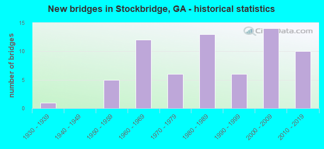
- New bridges - historical statistics
- 11930-1939
- 51950-1959
- 121960-1969
- 61970-1979
- 131980-1989
- 61990-1999
- 142000-2009
- 102010-2019

- Reconstructed bridges - Historical Statistics
- 11980-1989
- 21990-1999
- 12000-2009


- Bridge Condition - Deck
- 16.7%Very good
- 75.0%Good
- 2.8%Satisfactory
- 2.8%Fair
- 2.8%Imminent failure

- Bridge Condition - Superstructure
- 41.7%Very good
- 52.8%Good
- 2.8%Satisfactory
- 2.8%Imminent failure

- Bridge Condition - Substructure
- 13.9%Very good
- 80.6%Good
- 5.6%Fair

- Bridge Condition - Channel
- 5.9%Excellent
- 49.0%Very good
- 25.5%Good
- 15.7%Satisfactory
- 2.0%Fair
- 2.0%Poor

- Bridge Condition - Culverts
- 83.9%Good
- 16.1%Satisfactory
Find on map >> Show street view
Structure Number: 63003, Location: 4.4 MI E OF JONESBORO (Lat: 33.511389, Lng: -84.289358), Route carried "on" structure: City street 9106, Year Built: 1961, Status: Open, Structure Length: 1.62m (5.31ft), Average Daily Traffic: 6,500 (year 2012), Truck Traffic: 1%, Average Future Daily Traffic: 9,750 (year 2032), Features Intersected: LAKE SPIVEY, Facility Carried by Structure: LAKE JODECO ROAD
Minimum Vertical Clearance: 30+ m (98+ ft), Kilometerpoint: 6.437, Lanes on structure: 2, Base Highway Network: Yes, Owner: County Highway Agency, Approaching Roadway Width: 7.3m (24.0ft), Material/Design: Steel continuous, Design/Construction: Stringer/Multi-beam, Number Of Spans In Main Unit: 3, Length of Maximum Span: 5.5m (18.0ft), Curb-To-Curb Width: 6.9m (22.6ft), Out-to-Out Width: 7.6m (24.9ft)
Condition: Deck: Good, Superstructure: Good, Substructure: Good, Channel: Very good, Operating Rating: 66.2 metric tons, Method Used To Determine Operating Rating: Load Factor (LF), Inventory Rating: 39.9 metric tons, Method Used To Determine Inventory Rating: Load Factor (LF), Structural Evaluation: Better than present minimum criteria, Deck Geometry: High priority of replacement, Waterway Adequacy: Equal to present desirable criteria, Approach Roadway Alignment: Equal to present minimum criteria, Length Of Structure Improvement: 41.76m (137.01ft), Designated Inspection Frequency: Every 24 months, Underwater Inspection Frequency: Every 60 months, Inspection Date: April 2021, Underwater Inspection Date: January 2019, Bridge Improvement Cost: $80,000, Roadway Improvement Cost: $326,000, Total Project Cost: $454,000, Deck Structure Type: Concrete Cast-file-Place, Wearing Surface/Protective System: Wearing Surface: Bituminous
Find on map >> Show street view
Structure Number: 630066, Location: 0.3 MI S OF I-75 (Lat: 33.550581, Lng: -84.300425), Route carried "on" structure: City street 9114, Year Built: 1979, Status: Open, Structure Length: 1.10m (3.61ft), Average Daily Traffic: 6,520 (year 2012), Truck Traffic: 1%, Average Future Daily Traffic: 9,780 (year 2032), Design Load: HS 20+Mod, Features Intersected: REEVES CREEK, Facility Carried by Structure: FIELDER ROAD
Minimum Vertical Clearance: 30+ m (98+ ft), Kilometerpoint: 3.219, Lanes on structure: 2, Base Highway Network: Yes, Owner: County Highway Agency, Approaching Roadway Width: 6.7m (22.0ft), Skew: 3 degrees, Material/Design: Concrete, Design/Construction: Culvert, Number Of Spans In Main Unit: 3, Length of Maximum Span: 3.4m (11.2ft)
Condition: Channel: Very good, Culverts: Satisfactory, Operating Rating: 55.3 metric tons, Method Used To Determine Operating Rating: Field evaluation and documented engineering judgment, Inventory Rating: 32.6 metric tons, Method Used To Determine Inventory Rating: Field evaluation and documented engineering judgment, Structural Evaluation: Equal to present minimum criteria, Waterway Adequacy: Equal to present desirable criteria, Approach Roadway Alignment: Equal to present minimum criteria, Designated Inspection Frequency: Every 24 months, Inspection Date: April 2021
Find on map >> Show street view
Structure Number: 630067, Location: 1 MI N OF HENRY CO LINE (Lat: 33.554639, Lng: -84.299289), Route carried "on" structure: City street 9114, Year Built: 1969, Status: Open, Structure Length: 8.26m (27.10ft), Average Daily Traffic: 6,520 (year 2012), Truck Traffic: 1%, Average Future Daily Traffic: 9,780 (year 2032), Design Load: HS 15, Features Intersected: I-75, Facility Carried by Structure: FIELDER ROAD
Minimum Vertical Clearance: 30+ m (98+ ft), Kilometerpoint: 3.219, Lanes on structure: 2, Lanes under structure: 8, Base Highway Network: Yes, Owner: State Highway Agency, Approaching Roadway Width: 6.7m (22.0ft), Skew: 2 degrees, Material/Design: Steel, Design/Construction: Stringer/Multi-beam, Number Of Spans In Main Unit: 4, Length of Maximum Span: 22.6m (74.1ft), Curb or Sidewalk Widths: Left: 0.2m (0.7ft), Right: 0.2m (0.7ft), Curb-To-Curb Width: 8.7m (28.5ft), Out-to-Out Width: 10.0m (32.8ft)
Condition: Deck: Satisfactory, Superstructure: Good, Substructure: Good, Operating Rating: 36.2 metric tons, Method Used To Determine Operating Rating: Load Factor (LF), Inventory Rating: 21.7 metric tons, Method Used To Determine Inventory Rating: Load Factor (LF), Structural Evaluation: Somewhat better than minimum adequacy, Deck Geometry: Meets minimum limits, Underclear: Meets minimum limits, Approach Roadway Alignment: Better than present minimum criteria, Length Of Structure Improvement: 14.69m (48.20ft), Designated Inspection Frequency: Every 24 months, Inspection Date: April 2021, Bridge Improvement Cost: $427,000, Roadway Improvement Cost: $80,000, Total Project Cost: $647,000, Deck Structure Type: Concrete Cast-file-Place
Find on map >> Show street view
Structure Number: 630086, Location: 1.6 MI E JCT SR 42 IN REX (Lat: 33.593028, Lng: -84.268819), Route carried "on" structure: City street 9110, Year Built: 1932, Status: Closed, Structure Length: 2.90m (9.51ft), Average Daily Traffic: 8,420 (year 2012), Truck Traffic: 1%, Average Future Daily Traffic: 12,630 (year 2032), Features Intersected: BIG COTTON INDIAN CREEK, Facility Carried by Structure: REX CIRCLE
Minimum Vertical Clearance: 30+ m (98+ ft), Kilometerpoint: 0.000, Lanes on structure: 2, Base Highway Network: Yes, Owner: County Highway Agency, Approaching Roadway Width: 6.1m (20.0ft), Material/Design: Steel, Design/Construction: Truss - Thru, Number Of Spans In Main Unit: 1, Length of Maximum Span: 29.0m (95.1ft), Curb-To-Curb Width: 5.5m (18.0ft), Out-to-Out Width: 6.6m (21.7ft)
Condition: Deck: Fair, Superstructure: Imminent failure, Substructure: Fair, Channel: Satisfactory, Waterway Adequacy: Meets minimum limits, Approach Roadway Alignment: Meets minimum limits, Bridge Posting: Required (Relationship of Operating Rating to Maximum Legal Load: > 39.9% below), Length Of Structure Improvement: 44.56m (146.19ft), Designated Inspection Frequency: Every 24 months, Other Special Inspection Frequency: Every 6 months, Inspection Date: May 2021, Other Special Inspection Date: October 2021, Bridge Improvement Cost: $543,000, Roadway Improvement Cost: $349,000, Total Project Cost: $994,000, Deck Structure Type: Concrete Cast-file-Place
Find on map >> Show street view
Structure Number: 630088, Location: 2 MI E OF MORROW (Lat: 33.569058, Lng: -84.292319), Route carried "on" structure: City street 9114, Year Built: 1993, Status: Open, Structure Length: 1.04m (3.41ft), Average Daily Traffic: 9,560 (year 2012), Truck Traffic: 1%, Average Future Daily Traffic: 14,340 (year 2032), Design Load: HS 20+Mod, Features Intersected: PANTHER CREEK, Facility Carried by Structure: FIELDER ROAD
Minimum Vertical Clearance: 30+ m (98+ ft), Kilometerpoint: 4.828, Lanes on structure: 3, Base Highway Network: Yes, Owner: County Highway Agency, Approaching Roadway Width: 11.6m (38.1ft), Skew: 2 degrees, Material/Design: Concrete, Design/Construction: Culvert, Number Of Spans In Main Unit: 3, Length of Maximum Span: 3.4m (11.2ft)
Condition: Channel: Very good, Culverts: Good, Operating Rating: 55.3 metric tons, Method Used To Determine Operating Rating: Field evaluation and documented engineering judgment, Inventory Rating: 32.6 metric tons, Method Used To Determine Inventory Rating: Field evaluation and documented engineering judgment, Structural Evaluation: Better than present minimum criteria, Waterway Adequacy: Equal to present minimum criteria, Approach Roadway Alignment: Equal to present desirable criteria, Designated Inspection Frequency: Every 24 months, Inspection Date: April 2021
Find on map >> Show street view
Structure Number: 630106, Location: 4 MI E OF MORROW (Lat: 33.577786, Lng: -84.277967), Route carried "on" structure: US 23, Year Built: 1984, Status: Open, Structure Length: 9.24m (30.31ft), Average Daily Traffic: 20,100 (year 2012), Truck Traffic: 1%, Average Future Daily Traffic: 30,150 (year 2032), Design Load: HS 20+Mod, Features Intersected: I-675 (SR 413)
Minimum Vertical Clearance: 30+ m (98+ ft), Kilometerpoint: 1.609, Lanes on structure: 5, Lanes under structure: 4, Base Highway Network: Yes, Owner: State Highway Agency, Approaching Roadway Width: 21.3m (69.9ft), Skew: 1 degrees, Material/Design: Prestressed concrete continuous, Design/Construction: Box Beam or Girders - Multiple, Number Of Spans In Main Unit: 2, Length of Maximum Span: 46.9m (153.9ft), Curb-To-Curb Width: 25.0m (82.0ft), Out-to-Out Width: 26.0m (85.3ft)
Condition: Deck: Good, Superstructure: Good, Substructure: Good, Operating Rating: 46.2 metric tons, Method Used To Determine Operating Rating: Allowable Stress (AS), Inventory Rating: 32.6 metric tons, Method Used To Determine Inventory Rating: Allowable Stress (AS), Structural Evaluation: Better than present minimum criteria, Deck Geometry: Superior to present desirable criteria, Underclear: Superior to present desirable criteria, Approach Roadway Alignment: Equal to present desirable criteria, Designated Inspection Frequency: Every 24 months, Inspection Date: June 2021, Deck Structure Type: Concrete Precast Panels, Wearing Surface/Protective System: Wearing Surface: Epoxy Overlay
Find on map >> Show street view
Structure Number: 630108, Location: 4 MI E OF MORROW (Lat: 33.582597, Lng: -84.280119), Route carried "on" structure: County highway 89, Year Built: 1984, Status: Open, Structure Length: 9.78m (32.09ft), Average Daily Traffic: 1,930 (year 2012), Truck Traffic: 1%, Average Future Daily Traffic: 2,895 (year 2032), Design Load: HS 20+Mod, Features Intersected: I-675 (SR 413), Facility Carried by Structure: EVANS DRIVE
Minimum Vertical Clearance: 30+ m (98+ ft), Kilometerpoint: 0.000, Lanes on structure: 2, Lanes under structure: 5, Base Highway Network: Yes, Owner: State Highway Agency, Approaching Roadway Width: 9.8m (32.2ft), Skew: 2 degrees, Material/Design: Prestressed concrete continuous, Design/Construction: Box Beam or Girders - Single/Spread, Number Of Spans In Main Unit: 2, Length of Maximum Span: 49.7m (163.1ft), Curb-To-Curb Width: 13.4m (44.0ft), Out-to-Out Width: 14.4m (47.2ft)
Condition: Deck: Good, Superstructure: Good, Substructure: Good, Operating Rating: 46.2 metric tons, Method Used To Determine Operating Rating: Allowable Stress (AS), Inventory Rating: 32.6 metric tons, Method Used To Determine Inventory Rating: Allowable Stress (AS), Structural Evaluation: Better than present minimum criteria, Deck Geometry: Equal to present desirable criteria, Underclear: Superior to present desirable criteria, Approach Roadway Alignment: Equal to present minimum criteria, Designated Inspection Frequency: Every 24 months, Inspection Date: June 2021, Deck Structure Type: Concrete Cast-file-Place
Find on map >> Show street view
Structure Number: 630125, Location: 0.3 MI N OF HENRY CO LINE (Lat: 33.553214, Lng: -84.268522), Route carried "on" structure: Interstate 675, Year Built: 1984, Status: Open, Structure Length: 4.72m (15.49ft), Average Daily Traffic: 45,310 (year 2012), Truck Traffic: 1%, Average Future Daily Traffic: 67,965 (year 2032), Design Load: HS 20+Mod, Features Intersected: SR 138
Minimum Vertical Clearance: 30+ m (98+ ft), Kilometerpoint: 1.609, Lanes on structure: 2, Lanes under structure: 5, Base Highway Network: Yes, Owner: State Highway Agency, Approaching Roadway Width: 12.2m (40.0ft), Skew: 10 degrees, Material/Design: Prestressed concrete continuous, Design/Construction: Box Beam or Girders - Single/Spread, Number Of Spans In Main Unit: 1, Length of Maximum Span: 47.2m (154.9ft), Curb-To-Curb Width: 13.4m (44.0ft), Out-to-Out Width: 14.4m (47.2ft)
Condition: Deck: Good, Superstructure: Good, Substructure: Good, Operating Rating: 55.3 metric tons, Method Used To Determine Operating Rating: Load Factor (LF), Inventory Rating: 32.6 metric tons, Method Used To Determine Inventory Rating: Load Factor (LF), Structural Evaluation: Better than present minimum criteria, Deck Geometry: Superior to present desirable criteria, Underclear: Somewhat better than minimum adequacy, Approach Roadway Alignment: Equal to present desirable criteria, Designated Inspection Frequency: Every 24 months, Inspection Date: April 2021, Deck Structure Type: Concrete Cast-file-Place, Wearing Surface/Protective System: Wearing Surface: Epoxy Overlay
Find on map >> Show street view
Structure Number: 630126, Location: 0.3 MI N OF HENRY CO LINE (Lat: 33.553144, Lng: -84.268958), Route carried "on" structure: Interstate 675, Year Built: 1984, Status: Open, Structure Length: 4.72m (15.49ft), Average Daily Traffic: 55,960 (year 2012), Truck Traffic: 1%, Average Future Daily Traffic: 83,940 (year 2032), Design Load: HS 20+Mod, Features Intersected: SR 138
Minimum Vertical Clearance: 30+ m (98+ ft), Kilometerpoint: 1.609, Lanes on structure: 2, Lanes under structure: 5, Base Highway Network: Yes, Owner: State Highway Agency, Approaching Roadway Width: 12.2m (40.0ft), Skew: 10 degrees, Material/Design: Prestressed concrete continuous, Design/Construction: Box Beam or Girders - Single/Spread, Number Of Spans In Main Unit: 1, Length of Maximum Span: 47.2m (154.9ft), Curb-To-Curb Width: 13.4m (44.0ft), Out-to-Out Width: 14.4m (47.2ft)
Condition: Deck: Good, Superstructure: Good, Substructure: Good, Operating Rating: 69.8 metric tons, Method Used To Determine Operating Rating: Load Factor (LF), Inventory Rating: 40.8 metric tons, Method Used To Determine Inventory Rating: Load Factor (LF), Structural Evaluation: Better than present minimum criteria, Deck Geometry: Superior to present desirable criteria, Underclear: Somewhat better than minimum adequacy, Approach Roadway Alignment: Equal to present desirable criteria, Designated Inspection Frequency: Every 24 months, Inspection Date: April 2021, Deck Structure Type: Concrete Cast-file-Place, Wearing Surface/Protective System: Wearing Surface: Epoxy Overlay
Find on map >> Show street view
Structure Number: 630127, Location: 0.6 MI N OF HENRY CO LINE (Lat: 33.561642, Lng: -84.271386), Route carried "on" structure: Interstate 675, Year Built: 1984, Status: Open, Structure Length: 1.71m (5.61ft), Average Daily Traffic: 55,960 (year 2012), Truck Traffic: 1%, Average Future Daily Traffic: 83,940 (year 2032), Design Load: HS 20+Mod, Features Intersected: PANTHER CREEK
Minimum Vertical Clearance: 30+ m (98+ ft), Kilometerpoint: 1.609, Lanes on structure: 4, Base Highway Network: Yes, Owner: State Highway Agency, Approaching Roadway Width: 24.4m (80.1ft), Skew: 11 degrees, Material/Design: Concrete, Design/Construction: Culvert, Number Of Spans In Main Unit: 5, Length of Maximum Span: 3.0m (9.8ft)
Condition: Channel: Very good, Culverts: Good, Structural Evaluation: Better than present minimum criteria, Waterway Adequacy: Superior to present desirable criteria, Approach Roadway Alignment: Equal to present desirable criteria, Designated Inspection Frequency: Every 24 months, Underwater Inspection Frequency: Every 60 months, Inspection Date: April 2021, Underwater Inspection Date: January 2019
Find on map >> Show street view
Structure Number: 635003, Location: 3.5 MI E OF MORROW (Lat: 33.584369, Lng: -84.260528), Route carried "on" structure: County highway 109, Year Built: 1990, Status: Open, Structure Length: 1.34m (4.40ft), Average Daily Traffic: 1,930 (year 2012), Truck Traffic: 1%, Average Future Daily Traffic: 2,895 (year 2032), Design Load: HS 20+Mod, Features Intersected: BIG COTTON INDIAN CREEK, Facility Carried by Structure: HOMESTEAD ROAD
Minimum Vertical Clearance: 30+ m (98+ ft), Kilometerpoint: 1.609, Lanes on structure: 2, Base Highway Network: Yes, Owner: County Highway Agency, Approaching Roadway Width: 6.1m (20.0ft), Material/Design: Concrete, Design/Construction: Culvert, Number Of Spans In Main Unit: 4, Length of Maximum Span: 3.0m (9.8ft)
Condition: Channel: Very good, Culverts: Good, Operating Rating: 55.3 metric tons, Method Used To Determine Operating Rating: Field evaluation and documented engineering judgment, Inventory Rating: 32.6 metric tons, Method Used To Determine Inventory Rating: Field evaluation and documented engineering judgment, Structural Evaluation: Better than present minimum criteria, Waterway Adequacy: Equal to present desirable criteria, Approach Roadway Alignment: Equal to present desirable criteria, Designated Inspection Frequency: Every 24 months, Inspection Date: April 2021
Find on map >> Show street view
Structure Number: 635033, Location: 4 MI E OF MORROW (Lat: 33.585589, Lng: -84.278639), Route carried "on" structure: County highway 89, Year Built: 1984, Status: Open, Structure Length: 1.22m (4.00ft), Average Daily Traffic: 1,930 (year 2012), Truck Traffic: 1%, Average Future Daily Traffic: 2,895 (year 2032), Design Load: HS 20+Mod, Features Intersected: L COTTON INDIAN CRK TRIB, Facility Carried by Structure: EVANS DRIVE
Minimum Vertical Clearance: 30+ m (98+ ft), Kilometerpoint: 1.609, Lanes on structure: 2, Base Highway Network: Yes, Owner: County Highway Agency, Approaching Roadway Width: 9.8m (32.2ft), Skew: 1 degrees, Material/Design: Concrete, Design/Construction: Culvert, Number Of Spans In Main Unit: 4, Length of Maximum Span: 2.7m (8.9ft)
Condition: Channel: Good, Culverts: Good, Structural Evaluation: Better than present minimum criteria, Waterway Adequacy: Superior to present desirable criteria, Approach Roadway Alignment: Equal to present desirable criteria, Designated Inspection Frequency: Every 24 months, Inspection Date: April 2021
Find on map >> Show street view
Structure Number: 635056, Location: 3 MI EAST OF JONESBORO (Lat: 33.505489, Lng: -84.301158), Route carried "on" structure: County highway 559, Year Built: 2006, Status: Open, Structure Length: 1.01m (3.31ft), Average Daily Traffic: 200 (year 2012), Truck Traffic: 1%, Average Future Daily Traffic: 300 (year 2032), Design Load: HS 20+Mod, Features Intersected: LINE CREEK, Facility Carried by Structure: LAKE JODECO ROAD
Minimum Vertical Clearance: 30+ m (98+ ft), Kilometerpoint: 1.609, Lanes on structure: 2, Base Highway Network: Yes, Owner: County Highway Agency, Approaching Roadway Width: 6.1m (20.0ft), Material/Design: Concrete, Design/Construction: Culvert, Number Of Spans In Main Unit: 3, Length of Maximum Span: 3.0m (9.8ft)
Condition: Channel: Very good, Culverts: Good, Operating Rating: 58.0 metric tons, Method Used To Determine Operating Rating: Field evaluation and documented engineering judgment, Inventory Rating: 32.6 metric tons, Method Used To Determine Inventory Rating: Field evaluation and documented engineering judgment, Structural Evaluation: Better than present minimum criteria, Waterway Adequacy: Equal to present desirable criteria, Approach Roadway Alignment: Superior to present desirable criteria, Designated Inspection Frequency: Every 24 months, Inspection Date: March 2021
Find on map >> Show street view
Structure Number: 635073, Location: IN REX (Lat: 33.592369, Lng: -84.267356), Route carried "on" structure: City street 1351, Year Built: 2009, Status: Open, Structure Length: 20.88m (68.50ft), Average Daily Traffic: 8,420 (year 2012), Truck Traffic: 1%, Average Future Daily Traffic: 12,630 (year 2032), Design Load: HS 20+Mod, Features Intersected: BIG COTTON INDIAN CREEK, Facility Carried by Structure: REX ROAD
Minimum Vertical Clearance: 30+ m (98+ ft), Kilometerpoint: 1.609, Lanes on structure: 2, Lanes under structure: 4, Base Highway Network: Yes, Owner: County Highway Agency, Approaching Roadway Width: 6.1m (20.0ft), Skew: 2 degrees, Material/Design: Prestressed concrete, Design/Construction: Stringer/Multi-beam, Number Of Spans In Main Unit: 7, Length of Maximum Span: 44.2m (145.0ft), Curb or Sidewalk Widths: Left: 1.8m (5.9ft), Right: 1.8m (5.9ft), Curb-To-Curb Width: 12.2m (40.0ft), Out-to-Out Width: 16.6m (54.5ft)
Condition: Deck: Good, Superstructure: Good, Substructure: Good, Channel: Very good, Operating Rating: 59.8 metric tons, Method Used To Determine Operating Rating: Load Factor (LF), Inventory Rating: 30.8 metric tons, Method Used To Determine Inventory Rating: Load Factor (LF), Structural Evaluation: Better than present minimum criteria, Deck Geometry: Somewhat better than minimum adequacy, Waterway Adequacy: Superior to present desirable criteria, Approach Roadway Alignment: Equal to present desirable criteria, Designated Inspection Frequency: Every 24 months, Inspection Date: May 2021, Deck Structure Type: Concrete Cast-file-Place
Find on map >> Show street view
Structure Number: 1510012, Location: 3 MI SE OF MCDONOUGH (Lat: 33.523747, Lng: -84.194578), Route carried "on" structure: US 23, Year Built: 1975, Status: Open, Structure Length: 6.95m (22.80ft), Average Daily Traffic: 12,810 (year 2012), Truck Traffic: 1%, Average Future Daily Traffic: 19,215 (year 2032), Design Load: HS 20+Mod, Features Intersected: LITTLE COTTON INDIAN CR
Minimum Vertical Clearance: 30+ m (98+ ft), Kilometerpoint: 28.968, Lanes on structure: 2, Base Highway Network: Yes, Owner: State Highway Agency, Approaching Roadway Width: 8.5m (27.9ft), Skew: 1 degrees, Material/Design: Concrete, Design/Construction: Tee Beam, Number Of Spans In Main Unit: 6, Length of Maximum Span: 11.6m (38.1ft), Curb or Sidewalk Widths: Left: 0.2m (0.7ft), Right: 0.2m (0.7ft), Curb-To-Curb Width: 11.8m (38.7ft), Out-to-Out Width: 13.0m (42.7ft)
Condition: Deck: Good, Superstructure: Good, Substructure: Good, Channel: Good, Operating Rating: 41.7 metric tons, Method Used To Determine Operating Rating: Load Factor (LF), Inventory Rating: 24.4 metric tons, Method Used To Determine Inventory Rating: Load Factor (LF), Structural Evaluation: Equal to present minimum criteria, Deck Geometry: Somewhat better than minimum adequacy, Waterway Adequacy: Equal to present desirable criteria, Approach Roadway Alignment: Better than present minimum criteria, Designated Inspection Frequency: Every 24 months, Underwater Inspection Frequency: Every 60 months, Inspection Date: December 2020, Underwater Inspection Date: July 2019, Bridge Improvement Cost: $891,000, Roadway Improvement Cost: $89,000, Total Project Cost: $1,336,000, Deck Structure Type: Concrete Cast-file-Place
Find on map >> Show street view
Structure Number: 1510013, Location: 2 MI NE OF STOCKBRIDGE (Lat: 33.569119, Lng: -84.262100), Route carried "on" structure: US 23, Year Built: 1970, Status: Open, Structure Length: 1.31m (4.30ft), Average Daily Traffic: 13,670 (year 2011), Truck Traffic: 1%, Average Future Daily Traffic: 20,505 (year 2031), Design Load: HS 20+Mod, Features Intersected: PANTHER CREEK
Minimum Vertical Clearance: 30+ m (98+ ft), Kilometerpoint: 37.015, Lanes on structure: 2, Base Highway Network: Yes, Owner: State Highway Agency, Approaching Roadway Width: 8.5m (27.9ft), Material/Design: Concrete, Design/Construction: Culvert, Number Of Spans In Main Unit: 4, Length of Maximum Span: 3.0m (9.8ft)
Condition: Channel: Satisfactory, Culverts: Satisfactory, Operating Rating: 55.3 metric tons, Method Used To Determine Operating Rating: Field evaluation and documented engineering judgment, Inventory Rating: 32.6 metric tons, Method Used To Determine Inventory Rating: Field evaluation and documented engineering judgment, Structural Evaluation: Equal to present minimum criteria, Waterway Adequacy: Equal to present desirable criteria, Approach Roadway Alignment: Equal to present minimum criteria, Designated Inspection Frequency: Every 24 months, Inspection Date: December 2020, Bridge Improvement Cost: $168,000, Roadway Improvement Cost: $17,000, Total Project Cost: $252,000
Find on map >> Show street view
Structure Number: 1510027, Location: 3 MI S OF STOCKBRIDGE (Lat: 33.495239, Lng: -84.240847), Route carried "on" structure: County highway 1415, Year Built: 1954, Year Reconstructed: 1998, Status: Open, Structure Length: 0.98m (3.22ft), Average Daily Traffic: 10,740 (year 2011), Truck Traffic: 1%, Average Future Daily Traffic: 16,110 (year 2031), Design Load: H 15, Features Intersected: PATES CREEK, Facility Carried by Structure: JODECO ROAD
Minimum Vertical Clearance: 30+ m (98+ ft), Kilometerpoint: 4.828, Lanes on structure: 2, Base Highway Network: Yes, Owner: County Highway Agency, Approaching Roadway Width: 7.0m (23.0ft), Material/Design: Concrete, Design/Construction: Culvert, Number Of Spans In Main Unit: 3, Length of Maximum Span: 3.0m (9.8ft)
Condition: Channel: Very good, Culverts: Good, Operating Rating: 41.7 metric tons, Method Used To Determine Operating Rating: Field evaluation and documented engineering judgment, Inventory Rating: 24.4 metric tons, Method Used To Determine Inventory Rating: Field evaluation and documented engineering judgment, Structural Evaluation: Equal to present minimum criteria, Waterway Adequacy: Equal to present minimum criteria, Approach Roadway Alignment: Better than present minimum criteria, Length Of Structure Improvement: 41.21m (135.20ft), Designated Inspection Frequency: Every 24 months, Inspection Date: October 2020, Bridge Improvement Cost: $125,000, Roadway Improvement Cost: $13,000, Total Project Cost: $188,000
Find on map >> Show street view
Structure Number: 1510038, Location: 4 MI NW OF MCDONOUGH (Lat: 33.469700, Lng: -84.212950), Route carried "on" structure: Interstate 75, Year Built: 1968, Status: Open, Structure Length: 1.22m (4.00ft), Average Daily Traffic: 137,340 (year 2011), Truck Traffic: 1%, Average Future Daily Traffic: 206,010 (year 2031), Design Load: HS 20+Mod, Features Intersected: WALNUT CREEK
Minimum Vertical Clearance: 30+ m (98+ ft), Kilometerpoint: 355.665, Lanes on structure: 6, Base Highway Network: Yes, Owner: State Highway Agency, Approaching Roadway Width: 35.4m (116.1ft), Skew: 10 degrees, Material/Design: Concrete, Design/Construction: Culvert, Number Of Spans In Main Unit: 4, Length of Maximum Span: 2.7m (8.9ft)
Condition: Channel: Good, Culverts: Good, Operating Rating: 55.3 metric tons, Method Used To Determine Operating Rating: Field evaluation and documented engineering judgment, Inventory Rating: 32.6 metric tons, Method Used To Determine Inventory Rating: Field evaluation and documented engineering judgment, Structural Evaluation: Better than present minimum criteria, Waterway Adequacy: Equal to present desirable criteria, Approach Roadway Alignment: Equal to present desirable criteria, Designated Inspection Frequency: Every 24 months, Inspection Date: December 2020, Bridge Improvement Cost: $327,000, Roadway Improvement Cost: $33,000, Total Project Cost: $490,000
Find on map >> Show street view
Structure Number: 1510039, Location: 3 MI S OF STOCKBRIDGE (Lat: 33.501189, Lng: -84.225947), Route carried "on" structure: Interstate 75, Year Built: 1968, Status: Open, Structure Length: 1.01m (3.31ft), Average Daily Traffic: 134,690 (year 2012), Truck Traffic: 1%, Average Future Daily Traffic: 202,035 (year 2032), Design Load: HS 20+Mod, Features Intersected: PATES CREEK
Minimum Vertical Clearance: 30+ m (98+ ft), Kilometerpoint: 360.493, Lanes on structure: 3, Base Highway Network: Yes, Owner: State Highway Agency, Approaching Roadway Width: 17.7m (58.1ft), Skew: 11 degrees, Material/Design: Concrete, Design/Construction: Culvert, Number Of Spans In Main Unit: 3, Length of Maximum Span: 3.0m (9.8ft)
Condition: Channel: Good, Culverts: Satisfactory, Structural Evaluation: Equal to present minimum criteria, Waterway Adequacy: Equal to present desirable criteria, Approach Roadway Alignment: Equal to present desirable criteria, Designated Inspection Frequency: Every 24 months, Underwater Inspection Frequency: Every 60 months, Inspection Date: December 2020, Underwater Inspection Date: December 2019, Bridge Improvement Cost: $164,000, Roadway Improvement Cost: $16,000, Total Project Cost: $246,000
Find on map >> Show street view
Structure Number: 151004, Location: 3 MI S OF STOCKBRIDGE (Lat: 33.500764, Lng: -84.226600), Route carried "on" structure: Interstate 75, Year Built: 1968, Status: Open, Structure Length: 0.98m (3.22ft), Average Daily Traffic: 134,690 (year 2012), Truck Traffic: 1%, Average Future Daily Traffic: 202,035 (year 2032), Design Load: HS 20+Mod, Features Intersected: PATES CREEK
Minimum Vertical Clearance: 30+ m (98+ ft), Kilometerpoint: 360.493, Lanes on structure: 4, Base Highway Network: Yes, Owner: State Highway Agency, Approaching Roadway Width: 17.7m (58.1ft), Skew: 10 degrees, Material/Design: Concrete, Design/Construction: Culvert, Number Of Spans In Main Unit: 3, Length of Maximum Span: 3.0m (9.8ft)
Condition: Channel: Good, Culverts: Good, Structural Evaluation: Better than present minimum criteria, Waterway Adequacy: Equal to present desirable criteria, Approach Roadway Alignment: Equal to present desirable criteria, Designated Inspection Frequency: Every 24 months, Underwater Inspection Frequency: Every 60 months, Inspection Date: December 2020, Underwater Inspection Date: December 2019, Bridge Improvement Cost: $193,000, Roadway Improvement Cost: $19,000, Total Project Cost: $290,000
Find on map >> Show street view
Structure Number: 1510041, Location: 2 MI S OF STOCKBRIDGE (Lat: 33.514419, Lng: -84.241092), Route carried "on" structure: Interstate 75, Year Built: 1968, Status: Open, Structure Length: 1.37m (4.49ft), Average Daily Traffic: 146,260 (year 2012), Truck Traffic: 13%, Average Future Daily Traffic: 219,390 (year 2032), Design Load: HS 20+Mod, Features Intersected: RUM CREEK
Minimum Vertical Clearance: 30+ m (98+ ft), Kilometerpoint: 362.102, Lanes on structure: 10, Base Highway Network: Yes, Owner: State Highway Agency, Approaching Roadway Width: 35.4m (116.1ft), Skew: 14 degrees, Material/Design: Concrete, Design/Construction: Culvert, Number Of Spans In Main Unit: 3, Length of Maximum Span: 4.3m (14.1ft)
Condition: Channel: Fair, Culverts: Good, Structural Evaluation: Better than present minimum criteria, Waterway Adequacy: Equal to present desirable criteria, Approach Roadway Alignment: Equal to present desirable criteria, Designated Inspection Frequency: Every 24 months, Underwater Inspection Frequency: Every 60 months, Inspection Date: December 2020, Underwater Inspection Date: December 2019, Bridge Improvement Cost: $464,000, Roadway Improvement Cost: $46,000, Total Project Cost: $695,000
Find on map >> Show street view
Structure Number: 1510042, Location: 2 MI S OF STOCKBRIDGE (Lat: 33.517756, Lng: -84.245181), Route carried "on" structure: Interstate 75, Year Built: 1969, Year Reconstructed: 1986, Status: Open, Structure Length: 5.85m (19.19ft), Average Daily Traffic: 145,530 (year 2011), Truck Traffic: 13%, Average Future Daily Traffic: 218,295 (year 2031), Design Load: HS 20+Mod, Features Intersected: FAS 1794 FLIPPEN ROAD
Minimum Vertical Clearance: 30+ m (98+ ft), Kilometerpoint: 362.102, Lanes on structure: 10, Lanes under structure: 2, Base Highway Network: Yes, Owner: State Highway Agency, Approaching Roadway Width: 36.0m (118.1ft), Skew: 33 degrees, Material/Design: Steel, Design/Construction: Stringer/Multi-beam, Number Of Spans In Main Unit: 3, Length of Maximum Span: 21.9m (71.9ft), Curb-To-Curb Width: 44.3m (145.3ft), Out-to-Out Width: 54.2m (177.8ft)
Condition: Deck: Good, Superstructure: Good, Substructure: Good, Operating Rating: 32.6 metric tons, Method Used To Determine Operating Rating: Load Factor (LF), Inventory Rating: 19.0 metric tons, Method Used To Determine Inventory Rating: Load Factor (LF), Structural Evaluation: Meets minimum limits, Deck Geometry: Equal to present desirable criteria, Underclear: Meets minimum limits, Approach Roadway Alignment: Equal to present desirable criteria, Designated Inspection Frequency: Every 24 months, Inspection Date: November 2020, Bridge Improvement Cost: $1,773,000, Roadway Improvement Cost: $177,000, Total Project Cost: $2,660,000, Deck Structure Type: Concrete Cast-file-Place
Find on map >> Show street view
Structure Number: 1510044, Location: 2 MI W OF STOCKBRIDGE (Lat: 33.539050, Lng: -84.264667), Route carried "on" structure: Interstate 75, Year Built: 1968, Status: Open, Structure Length: 1.25m (4.10ft), Average Daily Traffic: 145,530 (year 2011), Truck Traffic: 13%, Average Future Daily Traffic: 218,295 (year 2031), Design Load: HS 20+Mod, Features Intersected: REEVES CREEK
Minimum Vertical Clearance: 30+ m (98+ ft), Kilometerpoint: 365.321, Lanes on structure: 7, Base Highway Network: Yes, Owner: State Highway Agency, Approaching Roadway Width: 17.7m (58.1ft), Skew: 14 degrees, Material/Design: Concrete, Design/Construction: Culvert, Number Of Spans In Main Unit: 3, Length of Maximum Span: 4.0m (13.1ft)
Condition: Channel: Satisfactory, Culverts: Satisfactory, Structural Evaluation: Equal to present minimum criteria, Waterway Adequacy: Equal to present desirable criteria, Approach Roadway Alignment: Equal to present desirable criteria, Designated Inspection Frequency: Every 24 months, Inspection Date: December 2020, Bridge Improvement Cost: $248,000, Roadway Improvement Cost: $25,000, Total Project Cost: $371,000
Find on map >> Show street view
Structure Number: 1510045, Location: 2 MI W OF STOCKBRIDGE (Lat: 33.538981, Lng: -84.265917), Route carried "on" structure: Interstate 75, Year Built: 1968, Status: Open, Structure Length: 0.88m (2.89ft), Average Daily Traffic: 145,530 (year 2011), Truck Traffic: 13%, Average Future Daily Traffic: 218,295 (year 2031), Design Load: HS 20+Mod, Features Intersected: REEVES CREEK
Minimum Vertical Clearance: 30+ m (98+ ft), Kilometerpoint: 365.321, Lanes on structure: 8, Base Highway Network: Yes, Owner: State Highway Agency, Approaching Roadway Width: 29.9m (98.1ft), Skew: 10 degrees, Material/Design: Concrete, Design/Construction: Culvert, Number Of Spans In Main Unit: 3, Length of Maximum Span: 2.7m (8.9ft)
Condition: Channel: Good, Culverts: Satisfactory, Structural Evaluation: Equal to present minimum criteria, Waterway Adequacy: Equal to present desirable criteria, Approach Roadway Alignment: Equal to present desirable criteria, Designated Inspection Frequency: Every 24 months, Inspection Date: January 2021, Bridge Improvement Cost: $206,000, Roadway Improvement Cost: $21,000, Total Project Cost: $309,000
Find on map >> Show street view
Structure Number: 1510046, Location: 2 MI W OF STOCKBRIDGE (Lat: 33.546792, Lng: -84.278472), Route carried "on" structure: Interstate 75, Year Built: 1969, Year Reconstructed: 1990, Status: Open, Structure Length: 4.94m (16.21ft), Average Daily Traffic: 113,990 (year 2011), Truck Traffic: 1%, Average Future Daily Traffic: 170,985 (year 2031), Design Load: HS 20+Mod, Features Intersected: SR 138
Minimum Vertical Clearance: 30+ m (98+ ft), Kilometerpoint: 366.931, Lanes on structure: 7, Lanes under structure: 4, Base Highway Network: Yes, Owner: State Highway Agency, Approaching Roadway Width: 39.0m (128.0ft), Skew: 32 degrees, Material/Design: Steel, Design/Construction: Stringer/Multi-beam, Number Of Spans In Main Unit: 3, Length of Maximum Span: 24.4m (80.1ft), Curb-To-Curb Width: 39.6m (129.9ft), Out-to-Out Width: 40.8m (133.9ft)
Condition: Deck: Good, Superstructure: Good, Substructure: Good, Operating Rating: 49.8 metric tons, Method Used To Determine Operating Rating: Load Factor (LF), Inventory Rating: 29.9 metric tons, Method Used To Determine Inventory Rating: Load Factor (LF), Structural Evaluation: Better than present minimum criteria, Deck Geometry: Superior to present desirable criteria, Underclear: Meets minimum limits, Approach Roadway Alignment: Equal to present desirable criteria, Designated Inspection Frequency: Every 24 months, Inspection Date: December 2020, Bridge Improvement Cost: $1,496,000, Roadway Improvement Cost: $150,000, Total Project Cost: $2,244,000, Deck Structure Type: Concrete Cast-file-Place
Find on map >> Show street view
Structure Number: 1510057, Location: 5.5 MI W OF MCDONOUGH (Lat: 33.464228, Lng: -84.253089), Route carried "on" structure: State highway 920, Year Built: 1981, Status: Open, Structure Length: 3.66m (12.01ft), Average Daily Traffic: 11,280 (year 2011), Truck Traffic: 2%, Average Future Daily Traffic: 16,920 (year 2031), Design Load: HS 20+Mod, Features Intersected: WALNUT CREEK, Facility Carried by Structure: JONESBORO ROAD
Minimum Vertical Clearance: 30+ m (98+ ft), Kilometerpoint: 4.828, Lanes on structure: 2, Base Highway Network: Yes, Owner: State Highway Agency, Approaching Roadway Width: 7.3m (24.0ft), Skew: 2 degrees, Material/Design: Concrete, Design/Construction: Tee Beam, Number Of Spans In Main Unit: 3, Length of Maximum Span: 12.2m (40.0ft), Curb-To-Curb Width: 12.2m (40.0ft), Out-to-Out Width: 13.2m (43.3ft)
Condition: Deck: Good, Superstructure: Good, Substructure: Good, Channel: Very good, Operating Rating: 67.1 metric tons, Method Used To Determine Operating Rating: Load Factor (LF), Inventory Rating: 40.8 metric tons, Method Used To Determine Inventory Rating: Load Factor (LF), Structural Evaluation: Better than present minimum criteria, Deck Geometry: Somewhat better than minimum adequacy, Waterway Adequacy: Equal to present desirable criteria, Approach Roadway Alignment: Equal to present minimum criteria, Designated Inspection Frequency: Every 24 months, Inspection Date: October 2020, Bridge Improvement Cost: $469,000, Roadway Improvement Cost: $47,000, Total Project Cost: $703,000, Deck Structure Type: Concrete Cast-file-Place
Find on map >> Show street view
Structure Number: 1510064, Location: 1 MI S OF STOCKBRIDGE (Lat: 33.533969, Lng: -84.246847), Route carried "on" structure: City street 9321, Year Built: 1956, Status: Open, Structure Length: 0.64m (2.10ft), Average Daily Traffic: 9,960 (year 2011), Truck Traffic: 1%, Average Future Daily Traffic: 14,940 (year 2031), Design Load: H 15, Features Intersected: REEVES CREEK, Facility Carried by Structure: FLIPPEN ROAD
Minimum Vertical Clearance: 30+ m (98+ ft), Kilometerpoint: 6.437, Lanes on structure: 2, Base Highway Network: Yes, Owner: County Highway Agency, Approaching Roadway Width: 7.3m (24.0ft), Material/Design: Concrete, Design/Construction: Culvert, Number Of Spans In Main Unit: 2, Length of Maximum Span: 3.0m (9.8ft)
Condition: Channel: Satisfactory, Culverts: Good, Operating Rating: 40.8 metric tons, Method Used To Determine Operating Rating: Field evaluation and documented engineering judgment, Inventory Rating: 24.4 metric tons, Method Used To Determine Inventory Rating: Field evaluation and documented engineering judgment, Structural Evaluation: Equal to present minimum criteria, Waterway Adequacy: Equal to present desirable criteria, Approach Roadway Alignment: Equal to present desirable criteria, Designated Inspection Frequency: Every 24 months, Inspection Date: October 2020, Bridge Improvement Cost: $82,000, Roadway Improvement Cost: $8,000, Total Project Cost: $123,000
Find on map >> Show street view
Structure Number: 1510065, Location: 2 MI S OF STOCKBRIDGE (Lat: 33.514469, Lng: -84.245069), Route carried "on" structure: County highway 1794, Year Built: 1956, Status: Open, Structure Length: 0.64m (2.10ft), Average Daily Traffic: 12,370 (year 2011), Truck Traffic: 1%, Average Future Daily Traffic: 18,555 (year 2031), Design Load: H 15, Features Intersected: RUM CREEK, Facility Carried by Structure: FLIPPEN ROAD
Minimum Vertical Clearance: 30+ m (98+ ft), Kilometerpoint: 3.219, Lanes on structure: 2, Base Highway Network: Yes, Owner: County Highway Agency, Approaching Roadway Width: 7.3m (24.0ft), Material/Design: Concrete, Design/Construction: Culvert, Number Of Spans In Main Unit: 2, Length of Maximum Span: 3.0m (9.8ft)
Condition: Channel: Good, Culverts: Good, Operating Rating: 41.7 metric tons, Method Used To Determine Operating Rating: Field evaluation and documented engineering judgment, Inventory Rating: 24.4 metric tons, Method Used To Determine Inventory Rating: Field evaluation and documented engineering judgment, Structural Evaluation: Equal to present minimum criteria, Waterway Adequacy: Equal to present desirable criteria, Approach Roadway Alignment: Equal to present desirable criteria, Designated Inspection Frequency: Every 24 months, Inspection Date: October 2020, Bridge Improvement Cost: $82,000, Roadway Improvement Cost: $8,000, Total Project Cost: $123,000
Find on map >> Show street view
Structure Number: 1510068, Location: 2 MI NE OF STOCKBRIDGE (Lat: 33.558700, Lng: -84.203039), Route carried "on" structure: County highway 2039, Year Built: 1982, Status: Posted for load, Structure Length: 5.18m (16.99ft), Average Daily Traffic: 4,410 (year 2011), Truck Traffic: 1%, Average Future Daily Traffic: 6,615 (year 2031), Design Load: HS 20, Features Intersected: BIG COTTON INDIAN CREEK, Facility Carried by Structure: OLD CONYERS RD
Minimum Vertical Clearance: 30+ m (98+ ft), Kilometerpoint: 3.219, Lanes on structure: 2, Base Highway Network: Yes, Owner: County Highway Agency, Approaching Roadway Width: 7.3m (24.0ft), Material/Design: Concrete, Design/Construction: Tee Beam, Number Of Spans In Main Unit: 5, Length of Maximum Span: 10.4m (34.1ft), Curb-To-Curb Width: 14.6m (47.9ft), Out-to-Out Width: 15.6m (51.2ft)
Condition: Deck: Good, Superstructure: Good, Substructure: Good, Channel: Good, Operating Rating: 37.1 metric tons, Method Used To Determine Operating Rating: Load Factor (LF), Inventory Rating: 22.6 metric tons, Method Used To Determine Inventory Rating: Load Factor (LF), Structural Evaluation: Equal to present minimum criteria, Deck Geometry: Superior to present desirable criteria, Waterway Adequacy: Equal to present desirable criteria, Approach Roadway Alignment: Equal to present desirable criteria, Designated Inspection Frequency: Every 24 months, Inspection Date: November 2020, Bridge Improvement Cost: $664,000, Roadway Improvement Cost: $66,000, Total Project Cost: $996,000, Deck Structure Type: Concrete Cast-file-Place
Find on map >> Show street view
Structure Number: 1510069, Location: 4 MI NE OF STOCKBRIDGE (Lat: 33.572628, Lng: -84.195178), Route carried "on" structure: County highway 2039, Year Built: 1976, Status: Open, Structure Length: 1.37m (4.49ft), Average Daily Traffic: 3,440 (year 2011), Truck Traffic: 1%, Average Future Daily Traffic: 5,160 (year 2031), Features Intersected: JAMES CREEK, Facility Carried by Structure: OLD CONYERS RD
Minimum Vertical Clearance: 30+ m (98+ ft), Kilometerpoint: 4.828, Lanes on structure: 2, Base Highway Network: Yes, Owner: County Highway Agency, Approaching Roadway Width: 7.0m (23.0ft), Skew: 3 degrees, Material/Design: Steel continuous, Design/Construction: Stringer/Multi-beam, Number Of Spans In Main Unit: 2, Length of Maximum Span: 7.0m (23.0ft), Curb-To-Curb Width: 7.2m (23.6ft), Out-to-Out Width: 7.6m (24.9ft)
Condition: Deck: Good, Superstructure: Very good, Substructure: Good, Channel: Very good, Operating Rating: 58.9 metric tons, Method Used To Determine Operating Rating: Load Factor (LF), Inventory Rating: 35.3 metric tons, Method Used To Determine Inventory Rating: Load Factor (LF), Structural Evaluation: Better than present minimum criteria, Deck Geometry: High priority of replacement, Waterway Adequacy: Somewhat better than minimum adequacy, Approach Roadway Alignment: Somewhat better than minimum adequacy, Length Of Structure Improvement: 41.61m (136.52ft), Designated Inspection Frequency: Every 24 months, Inspection Date: November 2020, Bridge Improvement Cost: $176,000, Roadway Improvement Cost: $18,000, Total Project Cost: $264,000, Deck Structure Type: Concrete Cast-file-Place
Find on map >> Show street view
Structure Number: 1510076, Location: 3 MI E OF STOCKBRIDGE (Lat: 33.554758, Lng: -84.183269), Route carried "on" structure: County highway 2806, Year Built: 1989, Status: Open, Structure Length: 4.27m (14.01ft), Average Daily Traffic: 8,990 (year 2011), Truck Traffic: 1%, Average Future Daily Traffic: 13,485 (year 2031), Design Load: HS 20+Mod, Features Intersected: JAMES CREEK, Facility Carried by Structure: HEMPHILL ROAD
Minimum Vertical Clearance: 30+ m (98+ ft), Kilometerpoint: 1.609, Lanes on structure: 2, Base Highway Network: Yes, Owner: County Highway Agency, Approaching Roadway Width: 6.1m (20.0ft), Material/Design: Concrete, Design/Construction: Tee Beam, Number Of Spans In Main Unit: 4, Length of Maximum Span: 12.2m (40.0ft), Curb-To-Curb Width: 7.3m (24.0ft), Out-to-Out Width: 8.4m (27.6ft)
Condition: Deck: Good, Superstructure: Good, Substructure: Good, Channel: Good, Operating Rating: 48.9 metric tons, Method Used To Determine Operating Rating: Load Factor (LF), Inventory Rating: 29.0 metric tons, Method Used To Determine Inventory Rating: Load Factor (LF), Structural Evaluation: Better than present minimum criteria, Deck Geometry: High priority of replacement, Waterway Adequacy: Equal to present desirable criteria, Approach Roadway Alignment: Better than present minimum criteria, Designated Inspection Frequency: Every 24 months, Inspection Date: November 2020, Bridge Improvement Cost: $547,000, Roadway Improvement Cost: $55,000, Total Project Cost: $821,000, Deck Structure Type: Concrete Cast-file-Place
Find on map >> Show street view
Structure Number: 1510077, Location: 2 MI NE OF STOCKBRIDGE (Lat: 33.558008, Lng: -84.203697), Route carried "on" structure: County highway 2039, Year Built: 1982, Status: Open, Structure Length: 0.67m (2.20ft), Average Daily Traffic: 4,410 (year 2011), Truck Traffic: 1%, Average Future Daily Traffic: 6,615 (year 2031), Design Load: HS 20+Mod, Features Intersected: BIG COTTON INDIAN CREEK, Facility Carried by Structure: OLD CONYERS RD
Minimum Vertical Clearance: 30+ m (98+ ft), Kilometerpoint: 3.219, Lanes on structure: 2, Base Highway Network: Yes, Owner: County Highway Agency, Approaching Roadway Width: 7.3m (24.0ft), Skew: 3 degrees, Material/Design: Concrete, Design/Construction: Culvert, Number Of Spans In Main Unit: 4, Length of Maximum Span: 1.5m (4.9ft)
Condition: Channel: Good, Culverts: Good, Operating Rating: 55.3 metric tons, Method Used To Determine Operating Rating: Field evaluation and documented engineering judgment, Inventory Rating: 32.6 metric tons, Method Used To Determine Inventory Rating: Field evaluation and documented engineering judgment, Structural Evaluation: Better than present minimum criteria, Waterway Adequacy: Equal to present minimum criteria, Approach Roadway Alignment: Equal to present desirable criteria, Designated Inspection Frequency: Every 24 months, Inspection Date: October 2020, Bridge Improvement Cost: $86,000, Roadway Improvement Cost: $9,000, Total Project Cost: $129,000
Find on map >> Show street view
Structure Number: 1510078, Location: STOCKBRIDGE CITY LIMITS (Lat: 33.544328, Lng: -84.233108), Route carried "on" structure: US 23, Year Built: 1985, Status: Open, Structure Length: 9.14m (29.99ft), Average Daily Traffic: 29,320 (year 2011), Truck Traffic: 3%, Average Future Daily Traffic: 43,980 (year 2031), Design Load: HS 20+Mod, Features Intersected: NS RR-CR 556 & 568
Minimum Vertical Clearance: 30+ m (98+ ft), Kilometerpoint: 32.187, Lanes on structure: 5, Lanes under structure: 4, Base Highway Network: Yes, Owner: State Highway Agency, Approaching Roadway Width: 19.5m (64.0ft), Material/Design: Prestressed concrete, Design/Construction: Stringer/Multi-beam, Number Of Spans In Main Unit: 4, Length of Maximum Span: 27.4m (89.9ft), Curb or Sidewalk Widths: Left: 1.8m (5.9ft), Right: 0.0m, Curb-To-Curb Width: 20.7m (67.9ft), Out-to-Out Width: 23.4m (76.8ft)
Condition: Deck: Good, Superstructure: Good, Substructure: Good, Operating Rating: 65.3 metric tons, Method Used To Determine Operating Rating: Load Factor (LF), Inventory Rating: 30.8 metric tons, Method Used To Determine Inventory Rating: Load Factor (LF), Structural Evaluation: Better than present minimum criteria, Deck Geometry: Somewhat better than minimum adequacy, Underclear: Meets minimum limits, Approach Roadway Alignment: Better than present minimum criteria, Designated Inspection Frequency: Every 24 months, Inspection Date: November 2020, Bridge Improvement Cost: $2,131,000, Roadway Improvement Cost: $213,000, Total Project Cost: $3,197,000, Deck Structure Type: Concrete Cast-file-Place
Find on map >> Show street view
Structure Number: 1510079, Location: 2 MI W OF STOCKBRIDGE (Lat: 33.543500, Lng: -84.270389), Route carried "on" structure: Interstate 675, Year Built: 1985, Status: Open, Structure Length: 14.72m (48.29ft), Average Daily Traffic: 45,780 (year 2011), Truck Traffic: 1%, Average Future Daily Traffic: 68,670 (year 2031), Design Load: HS 20+Mod, Features Intersected: I-75
Minimum Vertical Clearance: 30+ m (98+ ft), Kilometerpoint: 0.000, Lanes on structure: 2, Lanes under structure: 6, Base Highway Network: Yes, Owner: State Highway Agency, Approaching Roadway Width: 14.0m (45.9ft), Skew: 9 degrees, Material/Design: Prestressed concrete, Design/Construction: Stringer/Multi-beam, Number Of Spans In Main Unit: 5, Length of Maximum Span: 34.1m (111.9ft), Curb or Sidewalk Widths: Left: 0.2m (0.7ft), Right: 0.2m (0.7ft), Curb-To-Curb Width: 13.4m (44.0ft), Out-to-Out Width: 14.5m (47.6ft)
Condition: Deck: Good, Superstructure: Good, Substructure: Good, Operating Rating: 35.3 metric tons, Method Used To Determine Operating Rating: Load Factor (LF), Inventory Rating: 20.8 metric tons, Method Used To Determine Inventory Rating: Load Factor (LF), Structural Evaluation: Somewhat better than minimum adequacy, Deck Geometry: Superior to present desirable criteria, Underclear: Equal to present minimum criteria, Approach Roadway Alignment: Better than present minimum criteria, Designated Inspection Frequency: Every 24 months, Inspection Date: December 2020, Bridge Improvement Cost: $1,887,000, Roadway Improvement Cost: $189,000, Total Project Cost: $2,831,000, Deck Structure Type: Concrete Cast-file-Place
Find on map >> Show street view
Structure Number: 151008, Location: 3 MI E OF STOCKBRIDGE (Lat: 33.541369, Lng: -84.284989), Route carried "on" structure: State highway 138, Year Built: 1953, Year Reconstructed: 2007, Status: Open, Structure Length: 0.91m (2.99ft), Average Daily Traffic: 16,720 (year 2012), Truck Traffic: 1%, Average Future Daily Traffic: 25,080 (year 2032), Design Load: H 15, Features Intersected: REEVES CREEK
Minimum Vertical Clearance: 30+ m (98+ ft), Kilometerpoint: 0.000, Lanes on structure: 6, Base Highway Network: Yes, Owner: State Highway Agency, Approaching Roadway Width: 17.1m (56.1ft), Skew: 29 degrees, Material/Design: Concrete, Design/Construction: Culvert, Number Of Spans In Main Unit: 2, Length of Maximum Span: 4.3m (14.1ft), Curb or Sidewalk Widths: Left: 2.1m (6.9ft), Right: 2.1m (6.9ft)
Condition: Channel: Satisfactory, Culverts: Good, Structural Evaluation: Better than present minimum criteria, Waterway Adequacy: Equal to present minimum criteria, Approach Roadway Alignment: Better than present minimum criteria, Designated Inspection Frequency: Every 24 months, Underwater Inspection Frequency: Every 60 months, Inspection Date: December 2020, Underwater Inspection Date: July 2019, Bridge Improvement Cost: $245,000, Roadway Improvement Cost: $25,000, Total Project Cost: $368,000
Find on map >> Show street view
Structure Number: 1515007, Location: 4 MI N OF McDONOUGH (Lat: 33.529558, Lng: -84.129239), Route carried "on" structure: County highway 124, Year Built: 1955, Status: Closed, Structure Length: 1.31m (4.30ft), Average Daily Traffic: 130 (year 2011), Truck Traffic: 4%, Average Future Daily Traffic: 195 (year 2031), Features Intersected: LITTLE COTTON INDIAN CR, Facility Carried by Structure: SELFRIDGE ROAD
Minimum Vertical Clearance: 30+ m (98+ ft), Kilometerpoint: 1.609, Lanes on structure: 1, Base Highway Network: Yes, Owner: County Highway Agency, Approaching Roadway Width: 6.4m (21.0ft), Material/Design: Steel, Design/Construction: Stringer/Multi-beam, Number Of Spans In Main Unit: 1, Length of Maximum Span: 13.1m (43.0ft), Curb-To-Curb Width: 3.7m (12.1ft), Out-to-Out Width: 4.3m (14.1ft)
Condition: Deck: Imminent failure, Superstructure: Satisfactory, Substructure: Fair, Channel: Poor, Operating Rating: 9.0 metric tons, Method Used To Determine Operating Rating: Allowable Stress (AS), Inventory Rating: 6.3 metric tons, Method Used To Determine Inventory Rating: Allowable Stress (AS), Waterway Adequacy: Somewhat better than minimum adequacy, Approach Roadway Alignment: High priority of replacement, Bridge Posting: Required (Relationship of Operating Rating to Maximum Legal Load: > 39.9% below), Length Of Structure Improvement: 162.24m (532.28ft), Designated Inspection Frequency: Every 24 months, Other Special Inspection Frequency: Every 6 months, Inspection Date: November 2020, Other Special Inspection Date: October 2021, Bridge Improvement Cost: $122,000, Roadway Improvement Cost: $12,000, Total Project Cost: $183,000, Deck Structure Type: Wood or Timber
Find on map >> Show street view
Structure Number: 1515013, Location: 3 MI NW OF McDONOUGH (Lat: 33.514819, Lng: -84.169028), Route carried "on" structure: County highway 142, Year Built: 1960, Status: Open, Structure Length: 0.98m (3.22ft), Average Daily Traffic: 4,460 (year 2011), Truck Traffic: 1%, Average Future Daily Traffic: 6,690 (year 2031), Design Load: H 15, Features Intersected: WOLF CREEK, Facility Carried by Structure: BRANNAN ROAD
Minimum Vertical Clearance: 30+ m (98+ ft), Kilometerpoint: 3.219, Lanes on structure: 2, Base Highway Network: Yes, Owner: County Highway Agency, Approaching Roadway Width: 6.1m (20.0ft), Material/Design: Concrete, Design/Construction: Culvert, Number Of Spans In Main Unit: 3, Length of Maximum Span: 3.0m (9.8ft)
Condition: Channel: Very good, Culverts: Good, Operating Rating: 41.7 metric tons, Method Used To Determine Operating Rating: Field evaluation and documented engineering judgment, Inventory Rating: 24.4 metric tons, Method Used To Determine Inventory Rating: Field evaluation and documented engineering judgment, Structural Evaluation: Equal to present minimum criteria, Waterway Adequacy: Equal to present desirable criteria, Approach Roadway Alignment: Better than present minimum criteria, Designated Inspection Frequency: Every 24 months, Inspection Date: December 2020, Bridge Improvement Cost: $125,000, Roadway Improvement Cost: $13,000, Total Project Cost: $188,000
Find on map >> Show street view
Structure Number: 1515014, Location: 3 MI NW OF McDONOUGH (Lat: 33.524019, Lng: -84.168008), Route carried "on" structure: County highway 144, Year Built: 1994, Status: Open, Structure Length: 6.40m (21.00ft), Average Daily Traffic: 1,940 (year 2011), Truck Traffic: 1%, Average Future Daily Traffic: 2,910 (year 2031), Design Load: HS 20+Mod, Features Intersected: LITTLE COTTON INDIAN CR, Facility Carried by Structure: SPRINGDALE DRIVE
Minimum Vertical Clearance: 30+ m (98+ ft), Kilometerpoint: 1.609, Lanes on structure: 2, Base Highway Network: Yes, Owner: County Highway Agency, Approaching Roadway Width: 9.1m (29.9ft), Skew: 4 degrees, Material/Design: Prestressed concrete, Design/Construction: Stringer/Multi-beam, Number Of Spans In Main Unit: 3, Length of Maximum Span: 27.4m (89.9ft), Curb-To-Curb Width: 7.3m (24.0ft), Out-to-Out Width: 8.3m (27.2ft)
Condition: Deck: Good, Superstructure: Very good, Substructure: Good, Channel: Good, Operating Rating: 67.1 metric tons, Method Used To Determine Operating Rating: Load Factor (LF), Inventory Rating: 21.7 metric tons, Method Used To Determine Inventory Rating: Load Factor (LF), Structural Evaluation: Somewhat better than minimum adequacy, Deck Geometry: Meets minimum limits, Waterway Adequacy: Equal to present desirable criteria, Approach Roadway Alignment: Equal to present desirable criteria, Designated Inspection Frequency: Every 24 months, Inspection Date: November 2020, Bridge Improvement Cost: $821,000, Roadway Improvement Cost: $82,000, Total Project Cost: $1,231,000, Deck Structure Type: Concrete Cast-file-Place
Find on map >> Show street view
Structure Number: 1515017, Location: .5 MI S OF STOCKBRIDGE (Lat: 33.531250, Lng: -84.235489), Route carried "on" structure: County highway 170, Year Built: 1989, Status: Open, Structure Length: 0.64m (2.10ft), Average Daily Traffic: 1,940 (year 2011), Truck Traffic: 1%, Average Future Daily Traffic: 2,910 (year 2031), Design Load: HS 20+Mod, Features Intersected: REEVES CREEK, Facility Carried by Structure: TYE ROAD
Minimum Vertical Clearance: 30+ m (98+ ft), Kilometerpoint: 1.609, Lanes on structure: 2, Base Highway Network: Yes, Owner: County Highway Agency, Approaching Roadway Width: 6.7m (22.0ft), Skew: 1 degrees, Material/Design: Concrete, Design/Construction: Culvert, Number Of Spans In Main Unit: 2, Length of Maximum Span: 3.0m (9.8ft)
Condition: Channel: Satisfactory, Culverts: Good, Operating Rating: 55.3 metric tons, Method Used To Determine Operating Rating: Field evaluation and documented engineering judgment, Inventory Rating: 32.6 metric tons, Method Used To Determine Inventory Rating: Field evaluation and documented engineering judgment, Structural Evaluation: Better than present minimum criteria, Waterway Adequacy: Equal to present desirable criteria, Approach Roadway Alignment: Equal to present desirable criteria, Designated Inspection Frequency: Every 24 months, Inspection Date: November 2020, Bridge Improvement Cost: $82,000, Roadway Improvement Cost: $8,000, Total Project Cost: $123,000
Find on map >> Show street view
Structure Number: 1515018, Location: 1 MI S OF STOCKBRIDGE (Lat: 33.519578, Lng: -84.230239), Route carried "on" structure: County highway 171, Year Built: 1972, Status: Open, Structure Length: 1.86m (6.10ft), Average Daily Traffic: 8,240 (year 2011), Truck Traffic: 1%, Average Future Daily Traffic: 12,360 (year 2031), Design Load: HS 20+Mod, Features Intersected: RUM CREEK, Facility Carried by Structure: ROCK QUARRY RD
Minimum Vertical Clearance: 30+ m (98+ ft), Kilometerpoint: 1.609, Lanes on structure: 2, Base Highway Network: Yes, Owner: County Highway Agency, Approaching Roadway Width: 7.3m (24.0ft), Skew: 4 degrees, Material/Design: Concrete, Design/Construction: Culvert, Number Of Spans In Main Unit: 4, Length of Maximum Span: 4.3m (14.1ft)
Condition: Channel: Good, Culverts: Good, Operating Rating: 55.3 metric tons, Method Used To Determine Operating Rating: Field evaluation and documented engineering judgment, Inventory Rating: 32.6 metric tons, Method Used To Determine Inventory Rating: Field evaluation and documented engineering judgment, Structural Evaluation: Better than present minimum criteria, Waterway Adequacy: Better than present minimum criteria, Approach Roadway Alignment: Better than present minimum criteria, Designated Inspection Frequency: Every 24 months, Inspection Date: November 2020, Bridge Improvement Cost: $238,000, Roadway Improvement Cost: $24,000, Total Project Cost: $358,000
Find on map >> Show street view
Structure Number: 1515019, Location: .5 MI S OF STOCKBRIDGE (Lat: 33.528558, Lng: -84.227058), Route carried "on" structure: County highway 171, Year Built: 1972, Status: Open, Structure Length: 0.98m (3.22ft), Average Daily Traffic: 8,240 (year 2011), Truck Traffic: 1%, Average Future Daily Traffic: 12,360 (year 2031), Design Load: HS 20+Mod, Features Intersected: REEVES CREEK, Facility Carried by Structure: ROCK QUARRY RD
Minimum Vertical Clearance: 30+ m (98+ ft), Kilometerpoint: 3.219, Lanes on structure: 2, Base Highway Network: Yes, Owner: County Highway Agency, Approaching Roadway Width: 7.3m (24.0ft), Material/Design: Concrete, Design/Construction: Culvert, Number Of Spans In Main Unit: 3, Length of Maximum Span: 3.0m (9.8ft)
Condition: Channel: Satisfactory, Culverts: Good, Operating Rating: 55.3 metric tons, Method Used To Determine Operating Rating: Field evaluation and documented engineering judgment, Inventory Rating: 32.6 metric tons, Method Used To Determine Inventory Rating: Field evaluation and documented engineering judgment, Structural Evaluation: Better than present minimum criteria, Waterway Adequacy: Equal to present desirable criteria, Approach Roadway Alignment: Better than present minimum criteria, Designated Inspection Frequency: Every 24 months, Inspection Date: November 2020, Bridge Improvement Cost: $125,000, Roadway Improvement Cost: $13,000, Total Project Cost: $188,000
Find on map >> Show street view
Structure Number: 1515021, Location: 2 MI S OF STOCKBRIDGE (Lat: 33.492758, Lng: -84.245189), Route carried "on" structure: County highway 165, Year Built: 1967, Status: Open, Structure Length: 1.13m (3.71ft), Average Daily Traffic: 1,940 (year 2011), Truck Traffic: 1%, Average Future Daily Traffic: 2,910 (year 2031), Design Load: H 15, Features Intersected: PATES CREEK, Facility Carried by Structure: FLIPPEN ROAD
Minimum Vertical Clearance: 30+ m (98+ ft), Kilometerpoint: 1.609, Lanes on structure: 2, Base Highway Network: Yes, Owner: County Highway Agency, Approaching Roadway Width: 7.3m (24.0ft), Skew: 3 degrees, Material/Design: Concrete, Design/Construction: Culvert, Number Of Spans In Main Unit: 3, Length of Maximum Span: 3.7m (12.1ft)
Condition: Channel: Satisfactory, Culverts: Good, Operating Rating: 41.7 metric tons, Method Used To Determine Operating Rating: Field evaluation and documented engineering judgment, Inventory Rating: 24.4 metric tons, Method Used To Determine Inventory Rating: Field evaluation and documented engineering judgment, Structural Evaluation: Equal to present minimum criteria, Waterway Adequacy: Equal to present desirable criteria, Approach Roadway Alignment: Better than present minimum criteria, Designated Inspection Frequency: Every 24 months, Inspection Date: October 2020, Bridge Improvement Cost: $145,000, Roadway Improvement Cost: $14,000, Total Project Cost: $217,000
Find on map >> Show street view
Structure Number: 1515055, Location: 2 MI N OF STOCKBRIDGE (Lat: 33.570758, Lng: -84.235539), Route carried "on" structure: City street 9113, Year Built: 1991, Status: Open, Structure Length: 5.18m (16.99ft), Average Daily Traffic: 2,330 (year 2012), Truck Traffic: 1%, Average Future Daily Traffic: 3,495 (year 2032), Design Load: HS 20+Mod, Features Intersected: BIG COTTON INDIAN CREEK, Facility Carried by Structure: STAGECOACH RD
Minimum Vertical Clearance: 30+ m (98+ ft), Kilometerpoint: 0.000, Lanes on structure: 2, Base Highway Network: Yes, Owner: County Highway Agency, Approaching Roadway Width: 7.0m (23.0ft), Material/Design: Prestressed concrete, Design/Construction: Stringer/Multi-beam, Number Of Spans In Main Unit: 2, Length of Maximum Span: 25.9m (85.0ft), Curb-To-Curb Width: 9.8m (32.2ft), Out-to-Out Width: 10.8m (35.4ft)
Condition: Deck: Good, Superstructure: Very good, Substructure: Good, Channel: Very good, Operating Rating: 67.1 metric tons, Method Used To Determine Operating Rating: Load Factor (LF), Inventory Rating: 23.5 metric tons, Method Used To Determine Inventory Rating: Load Factor (LF), Structural Evaluation: Equal to present minimum criteria, Deck Geometry: Meets minimum limits, Waterway Adequacy: Equal to present desirable criteria, Approach Roadway Alignment: Somewhat better than minimum adequacy, Designated Inspection Frequency: Every 24 months, Underwater Inspection Frequency: Every 60 months, Inspection Date: December 2020, Underwater Inspection Date: July 2019, Bridge Improvement Cost: $664,000, Roadway Improvement Cost: $66,000, Total Project Cost: $996,000, Deck Structure Type: Concrete Cast-file-Place
Find on map >> Show street view
Structure Number: 1515061, Location: 3 MI NW OF McDONOUGH (Lat: 33.469658, Lng: -84.221369), Route carried "on" structure: County highway 159, Year Built: 1995, Status: Open, Structure Length: 0.98m (3.22ft), Average Daily Traffic: 410 (year 2011), Truck Traffic: 1%, Average Future Daily Traffic: 615 (year 2031), Design Load: H 15, Features Intersected: WALNUT CREEK, Facility Carried by Structure: MOUNT OLIVE ROAD
Minimum Vertical Clearance: 30+ m (98+ ft), Kilometerpoint: 1.609, Lanes on structure: 1, Base Highway Network: Yes, Owner: County Highway Agency, Approaching Roadway Width: 6.1m (20.0ft), Skew: 3 degrees, Material/Design: Aluminum, Iron, Design/Construction: Culvert, Number Of Spans In Main Unit: 2, Length of Maximum Span: 4.3m (14.1ft)
Condition: Channel: Good, Culverts: Good, Operating Rating: 41.7 metric tons, Method Used To Determine Operating Rating: Field evaluation and documented engineering judgment, Inventory Rating: 24.4 metric tons, Method Used To Determine Inventory Rating: Field evaluation and documented engineering judgment, Structural Evaluation: Equal to present minimum criteria, Waterway Adequacy: Better than present minimum criteria, Approach Roadway Alignment: Somewhat better than minimum adequacy, Designated Inspection Frequency: Every 24 months, Inspection Date: October 2020, Bridge Improvement Cost: $91,000, Roadway Improvement Cost: $9,000, Total Project Cost: $136,000