Bridge Statistics for Springfield, Virginia (VA)
Condition, Traffic, Stress, Structural Evaluation, Project Costs
- National Bridge Inventory (NBI) Statistics
- 246Number of bridges
- 3,937ft / 1,200mTotal length
- $200,962,000Total costs
- 15,182,879Total average daily traffic
- 457,406Total average daily truck traffic
- National Bridge Inventory (NBI) Registered Bridges for Springfield
- No street view available for this location
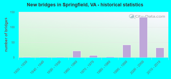
- New bridges - historical statistics
- 11920-1929
- 21930-1939
- 21940-1949
- 21950-1959
- 221960-1969
- 71970-1979
- 31980-1989
- 421990-1999
- 1332000-2009
- 322010-2019

- Reconstructed bridges - Historical Statistics
- 11930-1939
- 01940-1949
- 01950-1959
- 01960-1969
- 01970-1979
- 01980-1989
- 21990-1999
- 02000-2009
- 12010-2019


- Bridge Condition - Deck
- 8.7%Very good
- 65.2%Good
- 17.4%Satisfactory
- 8.7%Fair

- Bridge Condition - Superstructure
- 8.7%Very good
- 72.5%Good
- 7.2%Satisfactory
- 11.6%Fair

- Bridge Condition - Substructure
- 5.8%Very good
- 72.5%Good
- 8.7%Satisfactory
- 13.0%Fair

- Bridge Condition - Channel
- 10.5%Very good
- 15.8%Good
- 36.8%Satisfactory
- 36.8%Fair

- Bridge Condition - Culverts
- 8.3%Good
- 58.3%Satisfactory
- 33.3%Fair
Find on map >> Show street view
Structure Number: 229, Location: 00.16FR29/0.1TO Rte 6742 (Lat: 38.897419, Lng: -77.094625), Route carried "on" structure: State highway 124, Year Built: 1948, Status: Open, Structure Length: 0.91m (2.99ft), Average Daily Traffic: 17,709 (year 2020), Truck Traffic: 2%, Average Future Daily Traffic: 24,793 (year 2040), Design Load: HS 20, Features Intersected: SPOUT RUN, Facility Carried by Structure: SPOUT RUN PARKWAY
Minimum Vertical Clearance: 30+ m (98+ ft), Kilometerpoint: 0.241, Lanes on structure: 4, Owner: State Highway Agency, Approaching Roadway Width: 13.4m (44.0ft), Skew: 4 degrees, Material/Design: Concrete, Design/Construction: Culvert, Number Of Spans In Main Unit: 2, Length of Maximum Span: 4.6m (15.1ft)
Condition: Channel: Satisfactory, Culverts: Satisfactory, Operating Rating: 89.8 metric tons, Method Used To Determine Operating Rating: Load Factor (LF), Inventory Rating: 89.7 metric tons, Method Used To Determine Inventory Rating: Load Factor (LF), Structural Evaluation: Equal to present minimum criteria, Waterway Adequacy: Better than present minimum criteria, Approach Roadway Alignment: Equal to present desirable criteria, Designated Inspection Frequency: Every 24 months, Inspection Date: June 2020, Bridge Improvement Cost: $42,000, Roadway Improvement Cost: $98,000, Total Project Cost: $150,000
Find on map >> Show street view
Structure Number: 1709, Location: 0.16 RT 728 - 0.14 RT 737 (Lat: 38.270581, Lng: -79.149047), Route carried "on" structure: State highway 42, Year Built: 1949, Status: Open, Structure Length: 0.98m (3.22ft), Average Daily Traffic: 1,755 (year 2020), Truck Traffic: 6%, Average Future Daily Traffic: 1,930 (year 2040), Design Load: H 15, Features Intersected: ELK RUN, Facility Carried by Structure: Scenic Highway
Minimum Vertical Clearance: 30+ m (98+ ft), Kilometerpoint: 333.504, Lanes on structure: 2, Base Highway Network: Yes, Owner: State Highway Agency, Approaching Roadway Width: 7.3m (24.0ft), Material/Design: Concrete, Design/Construction: Tee Beam, Number Of Spans In Main Unit: 1, Length of Maximum Span: 9.8m (32.2ft), Curb or Sidewalk Widths: Left: 0.5m (1.6ft), Right: 0.5m (1.6ft), Curb-To-Curb Width: 7.3m (24.0ft), Out-to-Out Width: 7.8m (25.6ft)
Condition: Deck: Fair, Superstructure: Satisfactory, Substructure: Satisfactory, Channel: Fair, Operating Rating: 38.1 metric tons, Method Used To Determine Operating Rating: Load and Resistance Factor (LRFR), Inventory Rating: 22.7 metric tons, Method Used To Determine Inventory Rating: Load and Resistance Factor (LRFR), Structural Evaluation: Equal to present minimum criteria, Deck Geometry: Meets minimum limits, Waterway Adequacy: Equal to present minimum criteria, Approach Roadway Alignment: Equal to present minimum criteria, Length Of Structure Improvement: 0.98m (3.22ft), Designated Inspection Frequency: Every 24 months, Inspection Date: December 2020, Bridge Improvement Cost: $88,000, Roadway Improvement Cost: $21,000, Total Project Cost: $109,000, Deck Structure Type: Concrete Cast-file-Place, Wearing Surface/Protective System: Wearing Surface: Monolithic Concrete
Find on map >> Show street view
Structure Number: 5133, Location: .84FRRT.360 & .54TORT.651 (Lat: 37.467861, Lng: -77.507586), Route carried "on" structure: State highway 150, Year Built: 1979, Year Reconstructed: 1999, Status: Open, Structure Length: 5.49m (18.01ft), Average Daily Traffic: 35,000 (year 2020), Truck Traffic: 2%, Average Future Daily Traffic: 49,126 (year 2040), Design Load: HS 20+Mod, Features Intersected: RTE 647 (WALMSLEY BLVD)
Minimum Vertical Clearance: 30+ m (98+ ft), Kilometerpoint: 14.899, Lanes on structure: 3, Lanes under structure: 2, Base Highway Network: Yes, Owner: State Highway Agency, Approaching Roadway Width: 15.8m (51.8ft), Skew: 2 degrees, Material/Design: Steel, Design/Construction: Stringer/Multi-beam, Number Of Spans In Main Unit: 3, Length of Maximum Span: 31.7m (104.0ft), Curb-To-Curb Width: 15.7m (51.5ft), Out-to-Out Width: 16.7m (54.8ft)
Condition: Deck: Satisfactory, Superstructure: Good, Substructure: Satisfactory, Operating Rating: 35.4 metric tons, Method Used To Determine Operating Rating: Load and Resistance Factor (LRFR), Inventory Rating: 27.2 metric tons, Method Used To Determine Inventory Rating: Load and Resistance Factor (LRFR), Structural Evaluation: Equal to present minimum criteria, Deck Geometry: Somewhat better than minimum adequacy, Approach Roadway Alignment: Equal to present desirable criteria, Designated Inspection Frequency: Every 24 months, Inspection Date: November 2021, Deck Structure Type: Concrete Cast-file-Place, Wearing Surface/Protective System: Wearing Surface: Latex Concrete, Deck Protection: Epoxy Coated Reinforcing
Find on map >> Show street view
Structure Number: 6386, Location: 00.50FR95NB/00.40TO395NB (Lat: 38.792356, Lng: -77.171872), Route carried "on" structure: Ramp Interstate 495, Year Built: 1961, Year Reconstructed: 2018, Status: Open, Structure Length: 5.04m (16.54ft), Average Daily Traffic: 107,497 (year 2018), Truck Traffic: 4%, Average Future Daily Traffic: 240,379 (year 2031), Design Load: HS 20, Features Intersected: SOUTHERN RAILWAY
Minimum Vertical Clearance: 30.18m (99.02ft), Kilometerpoint: 0.402, Lanes on structure: 3, Base Highway Network: Yes, Owner: State Highway Agency, Approaching Roadway Width: 7.3m (24.0ft), Skew: 20 degrees, Material/Design: Prestressed concrete, Design/Construction: Stringer/Multi-beam, Number Of Spans In Main Unit: 3, Length of Maximum Span: 18.1m (59.4ft), Curb or Sidewalk Widths: Left: 0.0m, Right: 0.6m (2.0ft), Curb-To-Curb Width: 6.4m (21.0ft), Out-to-Out Width: 17.4m (57.1ft)
Condition: Deck: Good, Superstructure: Good, Substructure: Good, Operating Rating: 71.7 metric tons, Method Used To Determine Operating Rating: Load and Resistance Factor (LRFR), Inventory Rating: 52.6 metric tons, Method Used To Determine Inventory Rating: Load and Resistance Factor (LRFR), Structural Evaluation: Better than present minimum criteria, Deck Geometry: High priority of replacement, Underclear: Meets minimum limits, Approach Roadway Alignment: Equal to present desirable criteria, Length Of Structure Improvement: 0.30m (0.98ft), Designated Inspection Frequency: Every 24 months, Inspection Date: August 2020, Bridge Improvement Cost: $1,000, Roadway Improvement Cost: $2,000, Total Project Cost: $4,000, Deck Structure Type: Concrete Cast-file-Place, Wearing Surface/Protective System: Wearing Surface: Monolithic Concrete, Deck Protection: Other
Find on map >> Show street view
Structure Number: 6402, Location: 01.92 613 / 00.24 I-395 (Lat: 38.791397, Lng: -77.169764), Route carried "on" structure: Interstate 95, Year Built: 1962, Status: Open, Structure Length: 1.83m (6.00ft), Average Daily Traffic: 92,130 (year 2020), Truck Traffic: 4%, Average Future Daily Traffic: 128,982 (year 2040), Design Load: HS 20, Features Intersected: BACKLICK RUN, Facility Carried by Structure: CAPITAL BELTWAY IL
Minimum Vertical Clearance: 30+ m (98+ ft), Kilometerpoint: 275.704, Lanes on structure: 6, Base Highway Network: Yes, Owner: State Highway Agency, Approaching Roadway Width: 25.0m (82.0ft), Skew: 4 degrees, Material/Design: Concrete, Design/Construction: Culvert, Number Of Spans In Main Unit: 4, Length of Maximum Span: 4.6m (15.1ft)
Condition: Channel: Fair, Culverts: Satisfactory, Operating Rating: 89.8 metric tons, Method Used To Determine Operating Rating: Load Factor (LF), Inventory Rating: 65.3 metric tons, Method Used To Determine Inventory Rating: Load Factor (LF), Structural Evaluation: Equal to present minimum criteria, Waterway Adequacy: Equal to present desirable criteria, Approach Roadway Alignment: Equal to present desirable criteria, Length Of Structure Improvement: 49.50m (162.40ft), Designated Inspection Frequency: Every 24 months, Inspection Date: July 2020, Bridge Improvement Cost: $32,000, Roadway Improvement Cost: $100,000, Total Project Cost: $150,000 ( Estimate for 2014)
Find on map >> Show street view
Structure Number: 6439, Location: 0.05FR95NBL 0.15TO395NBL (Lat: 38.790878, Lng: -77.172464), Route carried "on" structure: Ramp Interstate 95, Year Built: 1961, Status: Open, Structure Length: 1.83m (6.00ft), Average Daily Traffic: 131,000 (year 1993), Truck Traffic: 6%, Average Future Daily Traffic: 276,233 (year 2040), Design Load: HS 20, Features Intersected: BACKLICK RUN
Minimum Vertical Clearance: 30+ m (98+ ft), Kilometerpoint: 0.000, Lanes on structure: 2, Base Highway Network: Yes, Owner: State Highway Agency, Approaching Roadway Width: 11.9m (39.0ft), Skew: 4 degrees, Material/Design: Concrete, Design/Construction: Culvert, Number Of Spans In Main Unit: 4, Length of Maximum Span: 4.6m (15.1ft)
Condition: Channel: Satisfactory, Culverts: Fair, Operating Rating: 89.8 metric tons, Method Used To Determine Operating Rating: Load Factor (LF), Inventory Rating: 65.3 metric tons, Method Used To Determine Inventory Rating: Load Factor (LF), Structural Evaluation: Somewhat better than minimum adequacy, Waterway Adequacy: Better than present minimum criteria, Approach Roadway Alignment: Better than present minimum criteria, Length Of Structure Improvement: 59.41m (194.91ft), Designated Inspection Frequency: Every 24 months, Inspection Date: July 2020, Bridge Improvement Cost: $61,000, Roadway Improvement Cost: $112,000, Total Project Cost: $175,000
Find on map >> Show street view
Structure Number: 6546, Location: 00.05FR495/01.06TO648 (Lat: 38.790914, Lng: -77.174836), Route carried "on" structure: Interstate 395, Year Built: 1961, Status: Open, Structure Length: 0.64m (2.10ft), Average Daily Traffic: 191,351 (year 2020), Truck Traffic: 3%, Average Future Daily Traffic: 208,629 (year 2040), Design Load: HS 20, Features Intersected: BACK LICK RUN, Facility Carried by Structure: SHIRLEY MEM. HWY.
Minimum Vertical Clearance: 30+ m (98+ ft), Kilometerpoint: 0.080, Lanes on structure: 10, Base Highway Network: Yes, Owner: State Highway Agency, Approaching Roadway Width: 20.7m (67.9ft), Material/Design: Concrete, Design/Construction: Culvert, Number Of Spans In Main Unit: 2, Length of Maximum Span: 3.0m (9.8ft)
Condition: Channel: Fair, Culverts: Satisfactory, Operating Rating: 89.8 metric tons, Method Used To Determine Operating Rating: Load Factor (LF), Inventory Rating: 89.8 metric tons, Method Used To Determine Inventory Rating: Load Factor (LF), Structural Evaluation: Equal to present minimum criteria, Waterway Adequacy: Superior to present desirable criteria, Approach Roadway Alignment: Equal to present desirable criteria, Length Of Structure Improvement: 9.02m (29.59ft), Designated Inspection Frequency: Every 24 months, Inspection Date: June 2021, Bridge Improvement Cost: $10,000, Roadway Improvement Cost: $55,000, Total Project Cost: $75,000 ( Estimate for 2015)
Find on map >> Show street view
Structure Number: 6551, Location: 0.82FR648 0.97TO236 (Lat: 38.809719, Lng: -77.151244), Route carried "on" structure: Interstate 395, Year Built: 1967, Status: Open, Structure Length: 0.67m (2.20ft), Average Daily Traffic: 141,779 (year 2020), Truck Traffic: 3%, Average Future Daily Traffic: 185,019 (year 2040), Design Load: HS 20, Features Intersected: TURKEY COCK RUN
Minimum Vertical Clearance: 30+ m (98+ ft), Kilometerpoint: 3.105, Lanes on structure: 11, Base Highway Network: Yes, Owner: State Highway Agency, Approaching Roadway Width: 30.5m (100.1ft), Skew: 3 degrees, Material/Design: Concrete, Design/Construction: Culvert, Number Of Spans In Main Unit: 2, Length of Maximum Span: 3.4m (11.2ft)
Condition: Channel: Fair, Culverts: Satisfactory, Operating Rating: 89.8 metric tons, Method Used To Determine Operating Rating: Load Factor (LF), Inventory Rating: 89.7 metric tons, Method Used To Determine Inventory Rating: Load Factor (LF), Structural Evaluation: Equal to present minimum criteria, Waterway Adequacy: Equal to present desirable criteria, Approach Roadway Alignment: Equal to present desirable criteria, Length Of Structure Improvement: 32.61m (106.99ft), Designated Inspection Frequency: Every 24 months, Inspection Date: June 2020, Bridge Improvement Cost: $55,000, Roadway Improvement Cost: $76,000, Total Project Cost: $150,000 ( Estimate for 2014)
Find on map >> Show street view
Structure Number: 6552, Location: 0.10FR648 / 0.30TO395 NB (Lat: 38.803094, Lng: -77.165969), Route carried "on" structure: Ramp Interstate 648, Year Built: 1967, Status: Open, Structure Length: 16.95m (55.61ft), Average Daily Traffic: 4,998 (year 2020), Truck Traffic: 2%, Average Future Daily Traffic: 6,997 (year 2040), Design Load: HS 20, Features Intersected: EDSALL RD. & RAMP-E, Facility Carried by Structure: RAMP C TO 395_NBL
Minimum Vertical Clearance: 30+ m (98+ ft), Kilometerpoint: 0.080, Lanes on structure: 1, Lanes under structure: 5, Base Highway Network: Yes, Owner: State Highway Agency, Approaching Roadway Width: 6.7m (22.0ft), Skew: 3 degrees, Material/Design: Steel, Design/Construction: Stringer/Multi-beam, Number Of Spans In Main Unit: 8, Length of Maximum Span: 27.1m (88.9ft), Curb or Sidewalk Widths: Left: 0.5m (1.6ft), Right: 0.5m (1.6ft), Curb-To-Curb Width: 6.7m (22.0ft), Out-to-Out Width: 8.2m (26.9ft)
Condition: Deck: Satisfactory, Superstructure: Good, Substructure: Fair, Operating Rating: 57.3 metric tons, Method Used To Determine Operating Rating: Load and Resistance Factor (LRFR), Inventory Rating: 44.2 metric tons, Method Used To Determine Inventory Rating: Load and Resistance Factor (LRFR), Structural Evaluation: Somewhat better than minimum adequacy, Deck Geometry: Equal to present minimum criteria, Underclear: Equal to present minimum criteria, Approach Roadway Alignment: Better than present minimum criteria, Length Of Structure Improvement: 17.07m (56.00ft), Designated Inspection Frequency: Every 24 months, Inspection Date: December 2020, Bridge Improvement Cost: $100,000, Roadway Improvement Cost: $30,000, Total Project Cost: $140,000 ( Estimate for 2014), Deck Structure Type: Concrete Cast-file-Place, Wearing Surface/Protective System: Wearing Surface: Latex Concrete
Find on map >> Show street view
Structure Number: 6554, Location: 1.93Fr495/0.73To236 (Lat: 38.810350, Lng: -77.149878), Route carried "on" structure: Interstate 395, Year Built: 1967, Status: Open, Structure Length: 7.35m (24.11ft), Average Daily Traffic: 71,259 (year 2020), Truck Traffic: 3%, Average Future Daily Traffic: 99,763 (year 2040), Design Load: HS 20+Mod, Features Intersected: RP.A TO REVERSIBLE LANES, Facility Carried by Structure: HEN.SHIRLEY MEM.HY
Minimum Vertical Clearance: 5.49m (18.01ft), Kilometerpoint: 3.427, Lanes on structure: 3, Lanes under structure: 1, Base Highway Network: Yes, Owner: State Highway Agency, Approaching Roadway Width: 20.7m (67.9ft), Skew: 3 degrees, Material/Design: Steel, Design/Construction: Stringer/Multi-beam, Number Of Spans In Main Unit: 3, Length of Maximum Span: 25.6m (84.0ft), Curb-To-Curb Width: 15.8m (51.8ft), Out-to-Out Width: 16.5m (54.1ft)
Condition: Deck: Fair, Superstructure: Fair, Substructure: Fair, Operating Rating: 77.7 metric tons, Method Used To Determine Operating Rating: Load and Resistance Factor (LRFR), Inventory Rating: 59.9 metric tons, Method Used To Determine Inventory Rating: Load and Resistance Factor (LRFR), Structural Evaluation: Somewhat better than minimum adequacy, Deck Geometry: Somewhat better than minimum adequacy, Underclear: Equal to present minimum criteria, Approach Roadway Alignment: Equal to present desirable criteria, Length Of Structure Improvement: 7.35m (24.11ft), Designated Inspection Frequency: Every 24 months, Inspection Date: July 2020, Bridge Improvement Cost: $1,950,000, Roadway Improvement Cost: $200,000, Total Project Cost: $2,250,000 ( Estimate for 2014), Deck Structure Type: Concrete Cast-file-Place, Wearing Surface/Protective System: Wearing Surface: Epoxy Overlay
Find on map >> Show street view
Structure Number: 6558, Location: 00.20 648 / 00.10 I-395NB (Lat: 38.803036, Lng: -77.163258), Route carried "on" structure: Ramp Interstate 395, Year Built: 1967, Status: Open, Structure Length: 12.86m (42.19ft), Average Daily Traffic: 4,998 (year 2020), Average Future Daily Traffic: 6,997 (year 2040), Design Load: HS 20, Features Intersected: ROUTE I-395 AND RAMP E, Facility Carried by Structure: RAMP C
Minimum Vertical Clearance: 30+ m (98+ ft), Kilometerpoint: 0.290, Lanes on structure: 1, Lanes under structure: 10, Base Highway Network: Yes, Owner: State Highway Agency, Approaching Roadway Width: 6.7m (22.0ft), Skew: 4 degrees, Material/Design: Steel, Design/Construction: Stringer/Multi-beam, Number Of Spans In Main Unit: 5, Length of Maximum Span: 29.0m (95.1ft), Curb or Sidewalk Widths: Left: 0.5m (1.6ft), Right: 0.5m (1.6ft), Curb-To-Curb Width: 6.7m (22.0ft), Out-to-Out Width: 8.2m (26.9ft)
Condition: Deck: Fair, Superstructure: Fair, Substructure: Fair, Operating Rating: 48.8 metric tons, Method Used To Determine Operating Rating: Load and Resistance Factor (LRFR), Inventory Rating: 37.6 metric tons, Method Used To Determine Inventory Rating: Load and Resistance Factor (LRFR), Structural Evaluation: Somewhat better than minimum adequacy, Deck Geometry: Equal to present minimum criteria, Underclear: High priority of corrective action, Approach Roadway Alignment: Equal to present minimum criteria, Designated Inspection Frequency: Every 24 months, Inspection Date: March 2021, Bridge Improvement Cost: $165,000, Roadway Improvement Cost: $5,000, Total Project Cost: $175,000 ( Estimate for 2015), Deck Structure Type: Concrete Cast-file-Place, Wearing Surface/Protective System: Wearing Surface: Monolithic Concrete
Find on map >> Show street view
Structure Number: 6584, Location: 0.24FR395 0.41TO617 (Lat: 38.792614, Lng: -77.179006), Route carried "on" structure: Interstate 495, Year Built: 1962, Year Reconstructed: 2002, Status: Open, Structure Length: 1.58m (5.18ft), Average Daily Traffic: 92,130 (year 2020), Truck Traffic: 4%, Average Future Daily Traffic: 128,982 (year 2040), Design Load: HS 20, Features Intersected: BACKLICK RUN
Minimum Vertical Clearance: 30+ m (98+ ft), Kilometerpoint: 0.595, Lanes on structure: 7, Base Highway Network: Yes, Owner: State Highway Agency, Approaching Roadway Width: 25.6m (84.0ft), Skew: 4 degrees, Material/Design: Concrete, Design/Construction: Culvert, Number Of Spans In Main Unit: 4, Length of Maximum Span: 4.0m (13.1ft)
Condition: Channel: Satisfactory, Culverts: Satisfactory, Operating Rating: 89.8 metric tons, Method Used To Determine Operating Rating: Load Factor (LF), Inventory Rating: 65.3 metric tons, Method Used To Determine Inventory Rating: Load Factor (LF), Structural Evaluation: Equal to present minimum criteria, Waterway Adequacy: Equal to present desirable criteria, Approach Roadway Alignment: Equal to present desirable criteria, Length Of Structure Improvement: 11.16m (36.61ft), Designated Inspection Frequency: Every 24 months, Inspection Date: July 2020, Bridge Improvement Cost: $44,000, Roadway Improvement Cost: $25,000, Total Project Cost: $79,000
Find on map >> Show street view
Structure Number: 6693, Location: 00.21FR1467/ 00.07TO707 (Lat: 38.797219, Lng: -77.185733), Route carried "on" structure: County highway 617, Year Built: 1966, Status: Open, Structure Length: 6.19m (20.31ft), Average Daily Traffic: 26,178 (year 2020), Truck Traffic: 3%, Average Future Daily Traffic: 28,796 (year 2040), Design Load: HS 20, Features Intersected: SOUTHERN RAILWAY, Facility Carried by Structure: BACKLICK ROAD
Minimum Vertical Clearance: 30+ m (98+ ft), Kilometerpoint: 11.421, Lanes on structure: 4, Owner: State Highway Agency, Approaching Roadway Width: 14.6m (47.9ft), Skew: 20 degrees, Material/Design: Steel, Design/Construction: Stringer/Multi-beam, Number Of Spans In Main Unit: 3, Length of Maximum Span: 23.5m (77.1ft), Curb or Sidewalk Widths: Left: 0.5m (1.6ft), Right: 1.5m (4.9ft), Curb-To-Curb Width: 14.6m (47.9ft), Out-to-Out Width: 18.4m (60.4ft)
Condition: Deck: Fair, Superstructure: Fair, Substructure: Fair, Operating Rating: 63.1 metric tons, Method Used To Determine Operating Rating: Load and Resistance Factor (LRFR), Inventory Rating: 48.6 metric tons, Method Used To Determine Inventory Rating: Load and Resistance Factor (LRFR), Structural Evaluation: Somewhat better than minimum adequacy, Deck Geometry: High priority of replacement, Underclear: Equal to present minimum criteria, Approach Roadway Alignment: Better than present minimum criteria, Length Of Structure Improvement: 6.34m (20.80ft), Designated Inspection Frequency: Every 24 months, Inspection Date: November 2020, Bridge Improvement Cost: $5,000,000, Roadway Improvement Cost: $10,000, Total Project Cost: $5,015,000, Deck Structure Type: Concrete Cast-file-Place, Wearing Surface/Protective System: Wearing Surface: Latex Concrete
Find on map >> Show street view
Structure Number: 67, Location: 00.07FR2723/00.03TO707 (Lat: 38.798594, Lng: -77.185414), Route carried "on" structure: County highway 617, Year Built: 1966, Status: Open, Structure Length: 1.28m (4.20ft), Average Daily Traffic: 26,178 (year 2020), Truck Traffic: 3%, Average Future Daily Traffic: 28,796 (year 2040), Design Load: HS 20, Features Intersected: BACKLICK RUN, Facility Carried by Structure: BACKLICK ROAD
Minimum Vertical Clearance: 30+ m (98+ ft), Kilometerpoint: 11.520, Lanes on structure: 4, Owner: State Highway Agency, Approaching Roadway Width: 14.6m (47.9ft), Skew: 4 degrees, Material/Design: Concrete, Design/Construction: Culvert, Number Of Spans In Main Unit: 3, Length of Maximum Span: 4.3m (14.1ft)
Condition: Channel: Fair, Culverts: Satisfactory, Operating Rating: 89.8 metric tons, Method Used To Determine Operating Rating: Load Factor (LF), Inventory Rating: 89.7 metric tons, Method Used To Determine Inventory Rating: Load Factor (LF), Structural Evaluation: Equal to present minimum criteria, Waterway Adequacy: Equal to present desirable criteria, Approach Roadway Alignment: Equal to present desirable criteria, Length Of Structure Improvement: 18.75m (61.52ft), Designated Inspection Frequency: Every 24 months, Inspection Date: July 2020, Bridge Improvement Cost: $39,000, Roadway Improvement Cost: $95,000, Total Project Cost: $150,000 ( Estimate for 2014)
Find on map >> Show street view
Structure Number: 6756, Location: 00.00FR.635/00.05TO1320 (Lat: 38.779861, Lng: -77.156978), Route carried "on" structure: County highway 644, Year Built: 1974, Status: Open, Structure Length: 4.48m (14.70ft), Average Daily Traffic: 24,614 (year 2020), Truck Traffic: 2%, Average Future Daily Traffic: 34,460 (year 2040), Design Load: HS 20, Features Intersected: METRO & CSX RWY, Facility Carried by Structure: FRANCONIA ROAD
Minimum Vertical Clearance: 30+ m (98+ ft), Kilometerpoint: 12.401, Lanes on structure: 7, Owner: State Highway Agency, Approaching Roadway Width: 33.5m (109.9ft), Skew: 21 degrees, Material/Design: Steel, Design/Construction: Stringer/Multi-beam, Number Of Spans In Main Unit: 2, Length of Maximum Span: 25.6m (84.0ft), Curb or Sidewalk Widths: Left: 2.4m (7.9ft), Right: 2.4m (7.9ft), Curb-To-Curb Width: 26.5m (86.9ft), Out-to-Out Width: 33.2m (108.9ft)
Condition: Deck: Satisfactory, Superstructure: Fair, Substructure: Fair, Operating Rating: 61.5 metric tons, Method Used To Determine Operating Rating: Load and Resistance Factor (LRFR), Inventory Rating: 47.4 metric tons, Method Used To Determine Inventory Rating: Load and Resistance Factor (LRFR), Structural Evaluation: Somewhat better than minimum adequacy, Deck Geometry: Meets minimum limits, Underclear: Meets minimum limits, Approach Roadway Alignment: Equal to present desirable criteria, Length Of Structure Improvement: 4.48m (14.70ft), Designated Inspection Frequency: Every 24 months, Inspection Date: July 2021, Bridge Improvement Cost: $200,000, Roadway Improvement Cost: $20,000, Total Project Cost: $250,000 ( Estimate for 2026), Deck Structure Type: Concrete Cast-file-Place, Wearing Surface/Protective System: Wearing Surface: Monolithic Concrete
Find on map >> Show street view
Structure Number: 6757, Location: 00.08 1179 / 00.20 6945 (Lat: 38.775081, Lng: -77.203575), Route carried "on" structure: County highway 644, Year Built: 1964, Status: Open, Structure Length: 4.88m (16.01ft), Average Daily Traffic: 29,700 (year 2020), Truck Traffic: 2%, Average Future Daily Traffic: 41,580 (year 2040), Design Load: HS 20, Features Intersected: ACCOTINK CREEK, Facility Carried by Structure: OLD KEENE MILL RD.
Minimum Vertical Clearance: 30+ m (98+ ft), Kilometerpoint: 8.270, Lanes on structure: 4, Owner: State Highway Agency, Approaching Roadway Width: 22.9m (75.1ft), Skew: 22 degrees, Material/Design: Steel, Design/Construction: Stringer/Multi-beam, Number Of Spans In Main Unit: 3, Length of Maximum Span: 16.2m (53.1ft), Curb or Sidewalk Widths: Left: 0.2m (0.7ft), Right: 1.5m (4.9ft), Curb-To-Curb Width: 17.4m (57.1ft), Out-to-Out Width: 24.4m (80.1ft)
Condition: Deck: Satisfactory, Superstructure: Good, Substructure: Good, Channel: Good, Operating Rating: 48.1 metric tons, Method Used To Determine Operating Rating: Load and Resistance Factor (LRFR), Inventory Rating: 37.2 metric tons, Method Used To Determine Inventory Rating: Load and Resistance Factor (LRFR), Structural Evaluation: Better than present minimum criteria, Deck Geometry: Somewhat better than minimum adequacy, Waterway Adequacy: Better than present minimum criteria, Approach Roadway Alignment: Better than present minimum criteria, Length Of Structure Improvement: 4.79m (15.72ft), Designated Inspection Frequency: Every 24 months, Inspection Date: January 2022, Bridge Improvement Cost: $65,000, Roadway Improvement Cost: $99,000, Total Project Cost: $200,000, Deck Structure Type: Concrete Cast-file-Place, Wearing Surface/Protective System: Wearing Surface: Latex Concrete
Find on map >> Show street view
Structure Number: 6774, Location: 01.2FR617/01.8TO401 (Lat: 38.802281, Lng: -77.164239), Route carried "on" structure: County highway 648, Year Built: 1967, Status: Open, Structure Length: 9.51m (31.20ft), Average Daily Traffic: 18,293 (year 2020), Truck Traffic: 3%, Average Future Daily Traffic: 20,853 (year 2040), Design Load: HS 20, Features Intersected: INTERSTATE 395, Facility Carried by Structure: EDSALL ROAD
Minimum Vertical Clearance: 30+ m (98+ ft), Kilometerpoint: 2.122, Lanes on structure: 6, Lanes under structure: 11, Owner: State Highway Agency, Approaching Roadway Width: 23.8m (78.1ft), Skew: 20 degrees, Material/Design: Steel, Design/Construction: Stringer/Multi-beam, Number Of Spans In Main Unit: 5, Length of Maximum Span: 24.1m (79.1ft), Curb or Sidewalk Widths: Left: 1.5m (4.9ft), Right: 1.5m (4.9ft), Curb-To-Curb Width: 23.8m (78.1ft), Out-to-Out Width: 32.3m (106.0ft)
Condition: Deck: Fair, Superstructure: Satisfactory, Substructure: Fair, Operating Rating: 57.2 metric tons, Method Used To Determine Operating Rating: Load and Resistance Factor (LRFR), Inventory Rating: 43.5 metric tons, Method Used To Determine Inventory Rating: Load and Resistance Factor (LRFR), Structural Evaluation: Somewhat better than minimum adequacy, Deck Geometry: Somewhat better than minimum adequacy, Underclear: Meets minimum limits, Approach Roadway Alignment: Better than present minimum criteria, Length Of Structure Improvement: 4.57m (14.99ft), Designated Inspection Frequency: Every 24 months, Inspection Date: December 2020, Bridge Improvement Cost: $275,000, Roadway Improvement Cost: $25,000, Total Project Cost: $310,000 ( Estimate for 2014), Deck Structure Type: Concrete Cast-file-Place, Wearing Surface/Protective System: Wearing Surface: Epoxy Overlay
Find on map >> Show street view
Structure Number: 6927, Location: 00.50FR1132/00.21TO1135 (Lat: 38.772931, Lng: -77.192689), Route carried "on" structure: County highway 1134, Year Built: 1950, Status: Open, Structure Length: 0.61m (2.00ft), Average Daily Traffic: 865 (year 2020), Average Future Daily Traffic: 952 (year 2040), Design Load: HS 20, Features Intersected: CALAMO BRANCH, Facility Carried by Structure: CALAMO ROAD
Minimum Vertical Clearance: 30+ m (98+ ft), Kilometerpoint: 0.848, Lanes on structure: 2, Owner: State Highway Agency, Approaching Roadway Width: 7.0m (23.0ft), Material/Design: Steel, Design/Construction: Culvert, Number Of Spans In Main Unit: 3, Length of Maximum Span: 1.5m (4.9ft)
Condition: Channel: Fair, Culverts: Fair, Operating Rating: 44.5 metric tons, Method Used To Determine Operating Rating: Field evaluation and documented engineering judgment, Inventory Rating: 32.7 metric tons, Method Used To Determine Inventory Rating: Field evaluation and documented engineering judgment, Structural Evaluation: Somewhat better than minimum adequacy, Waterway Adequacy: Somewhat better than minimum adequacy, Approach Roadway Alignment: Better than present minimum criteria, Length Of Structure Improvement: 11.10m (36.42ft), Designated Inspection Frequency: Every 24 months, Inspection Date: Febuary 2021, Bridge Improvement Cost: $39,000, Roadway Improvement Cost: $59,000, Total Project Cost: $100,000 ( Estimate for 2015)
Find on map >> Show street view
Structure Number: 6929, Location: 00.03FR1396/00.04TO1147 (Lat: 38.786583, Lng: -77.180106), Route carried "on" structure: County highway 1155, Year Built: 1973, Status: Open, Structure Length: 0.73m (2.40ft), Average Daily Traffic: 848 (year 2015), Average Future Daily Traffic: 954 (year 2040), Design Load: HS 20, Features Intersected: BRANCH OF BACKLICK RUN, Facility Carried by Structure: AUGUSTA DRIVE
Minimum Vertical Clearance: 30+ m (98+ ft), Kilometerpoint: 3.669, Lanes on structure: 2, Owner: State Highway Agency, Approaching Roadway Width: 11.0m (36.1ft), Material/Design: Steel, Design/Construction: Culvert, Number Of Spans In Main Unit: 5, Length of Maximum Span: 1.2m (3.9ft)
Condition: Channel: Satisfactory, Culverts: Fair, Operating Rating: 44.5 metric tons, Method Used To Determine Operating Rating: Field evaluation and documented engineering judgment, Inventory Rating: 32.7 metric tons, Method Used To Determine Inventory Rating: Field evaluation and documented engineering judgment, Structural Evaluation: Somewhat better than minimum adequacy, Waterway Adequacy: Better than present minimum criteria, Approach Roadway Alignment: Better than present minimum criteria, Length Of Structure Improvement: 2.74m (8.99ft), Designated Inspection Frequency: Every 24 months, Inspection Date: July 2020, Bridge Improvement Cost: $54,000, Roadway Improvement Cost: $72,000, Total Project Cost: $128,000 ( Estimate for 2014)
Find on map >> Show street view
Structure Number: 6958, Location: 00.03FR.2460/00.05TO2476 (Lat: 38.801611, Lng: -77.187167), Route carried "on" structure: County highway 2459, Year Built: 1970, Status: Open, Structure Length: 0.73m (2.40ft), Average Daily Traffic: 3,766 (year 2020), Truck Traffic: 2%, Average Future Daily Traffic: 4,467 (year 2040), Design Load: HS 20, Features Intersected: BACKLICK CREEK, Facility Carried by Structure: LEESVILLE BLVD.
Minimum Vertical Clearance: 30+ m (98+ ft), Kilometerpoint: 1.899, Lanes on structure: 2, Owner: State Highway Agency, Approaching Roadway Width: 11.0m (36.1ft), Material/Design: Steel, Design/Construction: Culvert, Number Of Spans In Main Unit: 1, Length of Maximum Span: 7.3m (24.0ft)
Condition: Channel: Satisfactory, Culverts: Satisfactory, Operating Rating: 44.5 metric tons, Method Used To Determine Operating Rating: Load Factor (LF), Inventory Rating: 32.7 metric tons, Method Used To Determine Inventory Rating: Load Factor (LF), Structural Evaluation: Equal to present minimum criteria, Waterway Adequacy: Equal to present desirable criteria, Approach Roadway Alignment: Better than present minimum criteria, Length Of Structure Improvement: 1.52m (4.99ft), Designated Inspection Frequency: Every 24 months, Inspection Date: December 2020, Bridge Improvement Cost: $49,000, Roadway Improvement Cost: $79,000, Total Project Cost: $155,000 ( Estimate for 2016)
Find on map >> Show street view
Structure Number: 14023, Location: 0.28 Fr 641 & 0.12 To 639 (Lat: 37.248781, Lng: -77.152278), Route carried "on" structure: State highway 10, Year Built: 1920, Status: Open, Structure Length: 1.28m (4.20ft), Average Daily Traffic: 2,714 (year 2020), Truck Traffic: 9%, Average Future Daily Traffic: 2,985 (year 2040), Design Load: HS 20+Mod, Features Intersected: POWELL CREEK, Facility Carried by Structure: JAMES RIVER ROAD
Minimum Vertical Clearance: 30+ m (98+ ft), Kilometerpoint: 55.194, Lanes on structure: 2, Base Highway Network: Yes, Owner: State Highway Agency, Approaching Roadway Width: 11.6m (38.1ft), Material/Design: Concrete, Design/Construction: Tee Beam, Number Of Spans In Main Unit: 1, Length of Maximum Span: 12.2m (40.0ft), Curb-To-Curb Width: 11.7m (38.4ft), Out-to-Out Width: 12.8m (42.0ft)
Condition: Deck: Satisfactory, Superstructure: Fair, Substructure: Satisfactory, Channel: Fair, Operating Rating: 37.6 metric tons, Method Used To Determine Operating Rating: Load and Resistance Factor (LRFR), Inventory Rating: 28.9 metric tons, Method Used To Determine Inventory Rating: Load and Resistance Factor (LRFR), Structural Evaluation: Somewhat better than minimum adequacy, Deck Geometry: Somewhat better than minimum adequacy, Waterway Adequacy: Equal to present minimum criteria, Approach Roadway Alignment: Equal to present desirable criteria, Designated Inspection Frequency: Every 24 months, Inspection Date: Febuary 2022, Deck Structure Type: Concrete Cast-file-Place, Wearing Surface/Protective System: Wearing Surface: Bituminous, Membrane: Preformed Fabric
Find on map >> Show street view
Structure Number: 14218, Location: 6.6FR245/01.92TO15 (Lat: 38.821778, Lng: -77.675653), Route carried "on" structure: Interstate 66, Year Built: 1980, Status: Open, Structure Length: 3.44m (11.29ft), Average Daily Traffic: 19,009 (year 2020), Truck Traffic: 8%, Average Future Daily Traffic: 26,613 (year 2040), Design Load: HS 20, Features Intersected: THOROUGHFARE ROAD
Minimum Vertical Clearance: 30+ m (98+ ft), Kilometerpoint: 62.220, Lanes on structure: 2, Lanes under structure: 2, Base Highway Network: Yes, Owner: State Highway Agency, Approaching Roadway Width: 11.3m (37.1ft), Material/Design: Prestressed concrete, Design/Construction: Stringer/Multi-beam, Number Of Spans In Main Unit: 3, Length of Maximum Span: 12.2m (40.0ft), Curb or Sidewalk Widths: Left: 0.2m (0.7ft), Right: 0.2m (0.7ft), Curb-To-Curb Width: 12.4m (40.7ft), Out-to-Out Width: 13.4m (44.0ft)
Condition: Deck: Good, Superstructure: Fair, Substructure: Fair, Operating Rating: 80.0 metric tons, Method Used To Determine Operating Rating: Load and Resistance Factor (LRFR), Inventory Rating: 61.7 metric tons, Method Used To Determine Inventory Rating: Load and Resistance Factor (LRFR), Structural Evaluation: Somewhat better than minimum adequacy, Deck Geometry: Better than present minimum criteria, Underclear: Meets minimum limits, Approach Roadway Alignment: Equal to present desirable criteria, Length Of Structure Improvement: 0.30m (0.98ft), Designated Inspection Frequency: Every 24 months, Inspection Date: April 2020, Bridge Improvement Cost: $1,000, Roadway Improvement Cost: $1,000, Total Project Cost: $3,000 ( Estimate for 2014), Deck Structure Type: Concrete Cast-file-Place, Wearing Surface/Protective System: Membrane: Epoxy
Find on map >> Show street view
Structure Number: 17601, Location: .05 TO R632; .45 TO R91 (Lat: 36.908008, Lng: -81.701978), Route carried "on" structure: County highway 633, Year Built: 1979, Status: Open, Structure Length: 6.16m (20.21ft), Average Daily Traffic: 313 (year 2020), Truck Traffic: 3%, Average Future Daily Traffic: 344 (year 2040), Design Load: HS 20, Features Intersected: N FORK HOLSTON RIVER, Facility Carried by Structure: POSSUM HOLLOW ROAD
Minimum Vertical Clearance: 30+ m (98+ ft), Kilometerpoint: 4.232, Lanes on structure: 2, Owner: State Highway Agency, Approaching Roadway Width: 6.7m (22.0ft), Material/Design: Prestressed concrete, Design/Construction: Tee Beam, Number Of Spans In Main Unit: 4, Length of Maximum Span: 15.2m (49.9ft), Curb-To-Curb Width: 7.9m (25.9ft), Out-to-Out Width: 9.2m (30.2ft)
Condition: Deck: Satisfactory, Superstructure: Satisfactory, Substructure: Fair, Channel: Satisfactory, Operating Rating: 54.4 metric tons, Method Used To Determine Operating Rating: Load and Resistance Factor (LRFR), Inventory Rating: 34.5 metric tons, Method Used To Determine Inventory Rating: Load and Resistance Factor (LRFR), Structural Evaluation: Somewhat better than minimum adequacy, Deck Geometry: Somewhat better than minimum adequacy, Waterway Adequacy: Better than present minimum criteria, Approach Roadway Alignment: Better than present minimum criteria, Designated Inspection Frequency: Every 24 months, Inspection Date: June 2021, Deck Structure Type: Concrete Cast-file-Place, Wearing Surface/Protective System: Wearing Surface: Monolithic Concrete
Find on map >> Show street view
Structure Number: 18853, Location: 0.36 FR. 690; 1.51 TO 689 (Lat: 36.808247, Lng: -82.099147), Route carried "on" structure: US 19, Year Built: 1932, Year Reconstructed: 1942, Status: Open, Structure Length: 0.70m (2.30ft), Average Daily Traffic: 14,860 (year 2020), Truck Traffic: 5%, Average Future Daily Traffic: 17,545 (year 2040), Design Load: H 15, Features Intersected: LITTLE MOCCASIN CREEK, Facility Carried by Structure: PORTERFIELD HWY
Minimum Vertical Clearance: 30+ m (98+ ft), Kilometerpoint: 38.368, Lanes on structure: 4, Base Highway Network: Yes, Owner: State Highway Agency, Approaching Roadway Width: 29.0m (95.1ft), Skew: 20 degrees, Material/Design: Concrete, Design/Construction: Slab, Number Of Spans In Main Unit: 1, Length of Maximum Span: 6.1m (20.0ft), Curb-To-Curb Width: 27.1m (88.9ft), Out-to-Out Width: 27.7m (90.9ft)
Condition: Deck: Fair, Superstructure: Fair, Substructure: Fair, Channel: Satisfactory, Operating Rating: 36.3 metric tons, Method Used To Determine Operating Rating: Load and Resistance Factor (LRFR), Inventory Rating: 28.1 metric tons, Method Used To Determine Inventory Rating: Load and Resistance Factor (LRFR), Structural Evaluation: Somewhat better than minimum adequacy, Deck Geometry: Superior to present desirable criteria, Waterway Adequacy: Better than present minimum criteria, Approach Roadway Alignment: Better than present minimum criteria, Length Of Structure Improvement: 0.70m (2.30ft), Designated Inspection Frequency: Every 24 months, Inspection Date: January 2022, Bridge Improvement Cost: $209,000, Roadway Improvement Cost: $25,000, Total Project Cost: $304,000 ( Estimate for 2016), Deck Structure Type: Concrete Cast-file-Place, Wearing Surface/Protective System: Wearing Surface: Bituminous
Find on map >> Show street view
Structure Number: 20048, Location: 0.17KEYS ST; 0.03SPUR LN (Lat: 36.609292, Lng: -82.193633), Route carried "on" structure: State highway 381, Year Built: 1959, Status: Open, Structure Length: 1.10m (3.61ft), Average Daily Traffic: 13,053 (year 2020), Truck Traffic: 4%, Average Future Daily Traffic: 14,358 (year 2040), Design Load: HS 20, Features Intersected: COMMONWLTH AV O LITTL CK
Minimum Vertical Clearance: 30+ m (98+ ft), Kilometerpoint: 0.257, Lanes on structure: 2, Base Highway Network: Yes, Owner: City or Municipal Highway Agency, Approaching Roadway Width: 29.0m (95.1ft), Skew: 3 degrees, Material/Design: Concrete, Design/Construction: Culvert, Number Of Spans In Main Unit: 3, Length of Maximum Span: 3.7m (12.1ft)
Condition: Channel: Very good, Culverts: Fair, Operating Rating: 38.1 metric tons, Method Used To Determine Operating Rating: Load Factor (LF), Inventory Rating: 22.7 metric tons, Method Used To Determine Inventory Rating: Load Factor (LF), Structural Evaluation: Somewhat better than minimum adequacy, Waterway Adequacy: Better than present minimum criteria, Approach Roadway Alignment: Better than present minimum criteria, Designated Inspection Frequency: Every 24 months, Inspection Date: December 2021
Find on map >> Show street view
Structure Number: 20049, Location: 0.05 TO 81;1.1 TOWCL-BRIS (Lat: 36.623783, Lng: -82.181219), Route carried "on" structure: Interstate 381, Year Built: 1987, Status: Open, Structure Length: 14.54m (47.70ft), Average Daily Traffic: 5,361 (year 2020), Truck Traffic: 4%, Average Future Daily Traffic: 7,505 (year 2040), Design Load: HS 20+Mod, Features Intersected: I-381N RAMP 1A & I-81/58
Minimum Vertical Clearance: 30+ m (98+ ft), Kilometerpoint: 1.883, Lanes on structure: 2, Lanes under structure: 7, Base Highway Network: Yes, Owner: State Highway Agency, Approaching Roadway Width: 14.9m (48.9ft), Material/Design: Steel continuous, Design/Construction: Stringer/Multi-beam, Number Of Spans In Main Unit: 4, Length of Maximum Span: 38.1m (125.0ft), Curb-To-Curb Width: 12.3m (40.4ft), Out-to-Out Width: 13.4m (44.0ft)
Condition: Deck: Satisfactory, Superstructure: Good, Substructure: Satisfactory, Operating Rating: 81.6 metric tons, Method Used To Determine Operating Rating: Load and Resistance Factor (LRFR), Inventory Rating: 62.6 metric tons, Method Used To Determine Inventory Rating: Load and Resistance Factor (LRFR), Structural Evaluation: Equal to present minimum criteria, Deck Geometry: Better than present minimum criteria, Underclear: High priority of corrective action, Approach Roadway Alignment: Better than present minimum criteria, Designated Inspection Frequency: Every 24 months, Other Special Inspection Frequency: Every 6 months, Inspection Date: July 2020, Other Special Inspection Date: January 2022, Deck Structure Type: Concrete Cast-file-Place
Find on map >> Show street view
Structure Number: 20051, Location: 0.15FR381;0.20TO I-81/58 (Lat: 36.624058, Lng: -82.180881), Route carried "on" structure: Ramp Interstate 381, Year Built: 1987, Status: Open, Structure Length: 11.34m (37.20ft), Average Daily Traffic: 877 (year 2020), Truck Traffic: 4%, Average Future Daily Traffic: 965 (year 2040), Design Load: HS 20+Mod, Features Intersected: I-381S(OVR);I-81/58(UND)
Minimum Vertical Clearance: 5.59m (18.34ft), Kilometerpoint: 0.000, Lanes on structure: 1, Lanes under structure: 6, Base Highway Network: Yes, Owner: State Highway Agency, Approaching Roadway Width: 14.9m (48.9ft), Material/Design: Steel continuous, Design/Construction: Stringer/Multi-beam, Number Of Spans In Main Unit: 4, Length of Maximum Span: 36.0m (118.1ft), Curb-To-Curb Width: 9.3m (30.5ft), Out-to-Out Width: 10.3m (33.8ft)
Condition: Deck: Satisfactory, Superstructure: Good, Substructure: Good, Operating Rating: 89.8 metric tons, Method Used To Determine Operating Rating: Load and Resistance Factor (LRFR), Inventory Rating: 81.6 metric tons, Method Used To Determine Inventory Rating: Load and Resistance Factor (LRFR), Structural Evaluation: Better than present minimum criteria, Deck Geometry: Equal to present desirable criteria, Underclear: High priority of corrective action, Approach Roadway Alignment: Better than present minimum criteria, Designated Inspection Frequency: Every 24 months, Other Special Inspection Frequency: Every 6 months, Inspection Date: July 2020, Other Special Inspection Date: January 2022, Deck Structure Type: Concrete Cast-file-Place
Find on map >> Show street view
Structure Number: 21269, Location: 0.22 RT 683 & 0.10 RT 611 (Lat: 37.062133, Lng: -80.739981), Route carried "on" structure: City street 789, Year Built: 1932, Status: Posted for load, Structure Length: 1.28m (4.20ft), Average Daily Traffic: 70 (year 1993), Truck Traffic: 1%, Average Future Daily Traffic: 250 (year 2032), Features Intersected: THORNSPRINGS BRANCH
Minimum Vertical Clearance: 30+ m (98+ ft), Kilometerpoint: 0.000, Lanes on structure: 2, Owner: Town or Township Highway Agency, Approaching Roadway Width: 6.1m (20.0ft), Skew: 2 degrees, Material/Design: Concrete, Design/Construction: Arch - Deck, Number Of Spans In Main Unit: 1, Length of Maximum Span: 12.8m (42.0ft), Curb or Sidewalk Widths: Left: 0.1m (0.3ft), Right: 0.1m (0.3ft), Curb-To-Curb Width: 4.7m (15.4ft), Out-to-Out Width: 5.5m (18.0ft)
Condition: Deck: Satisfactory, Superstructure: Fair, Substructure: Satisfactory, Channel: Good, Operating Rating: 13.6 metric tons, Method Used To Determine Operating Rating: Load Factor (LF), Inventory Rating: 9.1 metric tons, Method Used To Determine Inventory Rating: Load Factor (LF), Structural Evaluation: High priority of replacement, Waterway Adequacy: Better than present minimum criteria, Approach Roadway Alignment: Equal to present desirable criteria, Bridge Posting: Required (Relationship of Operating Rating to Maximum Legal Load: > 39.9% below), Length Of Structure Improvement: 1.28m (4.20ft), Designated Inspection Frequency: Every 12 months, Inspection Date: July 2021, Bridge Improvement Cost: $54,000, Roadway Improvement Cost: $1,000, Total Project Cost: $81,000, Deck Structure Type: Concrete Cast-file-Place, Wearing Surface/Protective System: Wearing Surface: Bituminous
Find on map >> Show street view
Structure Number: 23161, Location: 00.10FR617/01.50TO613 (Lat: 38.768456, Lng: -77.184461), Route carried "on" structure: County highway 289, Year Built: 1991, Status: Open, Structure Length: 42.98m (141.01ft), Average Daily Traffic: 29,246 (year 2020), Average Future Daily Traffic: 32,171 (year 2040), Design Load: HS 20, Features Intersected: RTE. 95-SBL&NBL&HOV, Facility Carried by Structure: FRAN/SPRNGFLD PKWY
Minimum Vertical Clearance: 30+ m (98+ ft), Kilometerpoint: 0.000, Lanes on structure: 6, Lanes under structure: 27, Base Highway Network: Yes, Owner: State Highway Agency, Approaching Roadway Width: 37.2m (122.0ft), Skew: 24 degrees, Material/Design: Prestressed concrete, Design/Construction: Stringer/Multi-beam, Number Of Spans In Main Unit: 15, Length of Maximum Span: 36.6m (120.1ft), Curb-To-Curb Width: 29.9m (98.1ft), Out-to-Out Width: 43.1m (141.4ft)
Condition: Deck: Good, Superstructure: Good, Substructure: Good, Operating Rating: 45.6 metric tons, Method Used To Determine Operating Rating: Load and Resistance Factor (LRFR), Inventory Rating: 27.5 metric tons, Method Used To Determine Inventory Rating: Load and Resistance Factor (LRFR), Structural Evaluation: Equal to present minimum criteria, Deck Geometry: Superior to present desirable criteria, Underclear: High priority of corrective action, Approach Roadway Alignment: Equal to present desirable criteria, Length Of Structure Improvement: 42.98m (141.01ft), Designated Inspection Frequency: Every 24 months, Inspection Date: August 2021, Bridge Improvement Cost: $350,000, Roadway Improvement Cost: $350,000, Total Project Cost: $800,000 ( Estimate for 2015), Deck Structure Type: Concrete Cast-file-Place, Wearing Surface/Protective System: Wearing Surface: Monolithic Concrete, Deck Protection: Epoxy Coated Reinforcing
Find on map >> Show street view
Structure Number: 23322, Location: 03.04FR617/00.30TO644 (Lat: 38.774833, Lng: -77.181611), Route carried "on" structure: Ramp Interstate 95, Year Built: 1992, Status: Open, Structure Length: 13.53m (44.39ft), Average Daily Traffic: 24,562 (year 2018), Truck Traffic: 8%, Average Future Daily Traffic: 250,000 (year 2034), Design Load: HS 20, Features Intersected: H.O.V. & ROUTE 95 SBL, Facility Carried by Structure: RAMP H-S
Minimum Vertical Clearance: 30+ m (98+ ft), Kilometerpoint: 14.143, Lanes on structure: 1, Lanes under structure: 9, Base Highway Network: Yes, Owner: State Highway Agency, Approaching Roadway Width: 7.3m (24.0ft), Skew: 3 degrees, Material/Design: Steel continuous, Design/Construction: Stringer/Multi-beam, Number Of Spans In Main Unit: 4, Length of Maximum Span: 39.3m (128.9ft), Curb-To-Curb Width: 9.4m (30.8ft), Out-to-Out Width: 10.5m (34.4ft)
Condition: Deck: Satisfactory, Superstructure: Good, Substructure: Good, Operating Rating: 50.9 metric tons, Method Used To Determine Operating Rating: Load and Resistance Factor (LRFR), Inventory Rating: 39.5 metric tons, Method Used To Determine Inventory Rating: Load and Resistance Factor (LRFR), Structural Evaluation: Better than present minimum criteria, Deck Geometry: Superior to present desirable criteria, Underclear: High priority of corrective action, Approach Roadway Alignment: Equal to present minimum criteria, Length Of Structure Improvement: 1.52m (4.99ft), Designated Inspection Frequency: Every 24 months, Inspection Date: September 2020, Bridge Improvement Cost: $100,000, Roadway Improvement Cost: $100,000, Total Project Cost: $210,000 ( Estimate for 2014), Deck Structure Type: Concrete Cast-file-Place, Wearing Surface/Protective System: Wearing Surface: Monolithic Concrete, Deck Protection: Epoxy Coated Reinforcing
Find on map >> Show street view
Structure Number: 23333, Location: 00.30 2677 / 00.55 613 (Lat: 38.767664, Lng: -77.166164), Route carried "on" structure: County highway 289, Year Built: 1992, Status: Open, Structure Length: 12.37m (40.58ft), Average Daily Traffic: 39,370 (year 2020), Truck Traffic: 1%, Average Future Daily Traffic: 52,135 (year 2040), Design Load: HS 20, Features Intersected: R.F.& P RAILROAD, Facility Carried by Structure: FRAN/SPRNGFLD PKWY
Minimum Vertical Clearance: 30+ m (98+ ft), Kilometerpoint: 0.000, Lanes on structure: 6, Lanes under structure: 2, Base Highway Network: Yes, Owner: State Highway Agency, Approaching Roadway Width: 41.5m (136.2ft), Skew: 24 degrees, Material/Design: Steel continuous, Design/Construction: Stringer/Multi-beam, Number Of Spans In Main Unit: 4, Length of Maximum Span: 35.1m (115.2ft), Curb or Sidewalk Widths: Left: 3.0m (9.8ft), Right: 0.0m, Curb-To-Curb Width: 38.1m (125.0ft), Out-to-Out Width: 42.2m (138.5ft)
Condition: Deck: Satisfactory, Superstructure: Good, Substructure: Good, Operating Rating: 78.0 metric tons, Method Used To Determine Operating Rating: Load and Resistance Factor (LRFR), Inventory Rating: 59.9 metric tons, Method Used To Determine Inventory Rating: Load and Resistance Factor (LRFR), Structural Evaluation: Better than present minimum criteria, Deck Geometry: Superior to present desirable criteria, Underclear: Superior to present desirable criteria, Approach Roadway Alignment: Equal to present desirable criteria, Length Of Structure Improvement: 12.37m (40.58ft), Designated Inspection Frequency: Every 24 months, Inspection Date: March 2020, Bridge Improvement Cost: $211,000, Roadway Improvement Cost: $100,000, Total Project Cost: $400,000, Deck Structure Type: Concrete Cast-file-Place, Wearing Surface/Protective System: Wearing Surface: Monolithic Concrete, Deck Protection: Epoxy Coated Reinforcing
Find on map >> Show street view
Structure Number: 23621, Location: 00.65FR286/02.00TO644 (Lat: 38.748747, Lng: -77.185408), Route carried "on" structure: Ramp Interstate 95, Year Built: 1993, Status: Open, Structure Length: 14.97m (49.11ft), Average Daily Traffic: 32,423 (year 2018), Truck Traffic: 8%, Average Future Daily Traffic: 20,175 (year 2034), Design Load: HS 20, Features Intersected: I-95 NBL
Minimum Vertical Clearance: 30.18m (99.02ft), Kilometerpoint: 0.000, Lanes on structure: 1, Lanes under structure: 4, Base Highway Network: Yes, Owner: State Highway Agency, Approaching Roadway Width: 10.1m (33.1ft), Material/Design: Steel continuous, Design/Construction: Stringer/Multi-beam, Number Of Spans In Main Unit: 4, Length of Maximum Span: 39.0m (128.0ft), Curb-To-Curb Width: 8.2m (26.9ft), Out-to-Out Width: 9.4m (30.8ft)
Condition: Deck: Good, Superstructure: Good, Substructure: Good, Operating Rating: 57.9 metric tons, Method Used To Determine Operating Rating: Load and Resistance Factor (LRFR), Inventory Rating: 44.6 metric tons, Method Used To Determine Inventory Rating: Load and Resistance Factor (LRFR), Structural Evaluation: Better than present minimum criteria, Deck Geometry: Superior to present desirable criteria, Underclear: Somewhat better than minimum adequacy, Approach Roadway Alignment: Equal to present desirable criteria, Length Of Structure Improvement: 0.30m (0.98ft), Designated Inspection Frequency: Every 24 months, Critical Feature Inspection Frequency: Every 24 months, Inspection Date: January 2021, Critical Feature Inspection Date: January 2021, Bridge Improvement Cost: $1,000, Roadway Improvement Cost: $1,000, Total Project Cost: $3,000 ( Estimate for 2015), Deck Structure Type: Concrete Cast-file-Place, Wearing Surface/Protective System: Deck Protection: Epoxy Coated Reinforcing
Find on map >> Show street view
Structure Number: 23622, Location: 01.40FR644/01.17TO617 (Lat: 38.756569, Lng: -77.184167), Route carried "on" structure: Ramp Interstate 95, Year Built: 1993, Status: Open, Structure Length: 12.83m (42.09ft), Average Daily Traffic: 8,522 (year 2020), Truck Traffic: 5%, Average Future Daily Traffic: 11,931 (year 2040), Design Load: HS 20, Features Intersected: BACKLICK ROAD
Minimum Vertical Clearance: 30+ m (98+ ft), Kilometerpoint: 271.181, Lanes on structure: 1, Lanes under structure: 5, Base Highway Network: Yes, Owner: State Highway Agency, Approaching Roadway Width: 10.1m (33.1ft), Material/Design: Steel continuous, Design/Construction: Stringer/Multi-beam, Number Of Spans In Main Unit: 4, Length of Maximum Span: 38.1m (125.0ft), Curb-To-Curb Width: 9.3m (30.5ft), Out-to-Out Width: 10.2m (33.5ft)
Condition: Deck: Good, Superstructure: Good, Substructure: Good, Operating Rating: 69.2 metric tons, Method Used To Determine Operating Rating: Load and Resistance Factor (LRFR), Inventory Rating: 53.5 metric tons, Method Used To Determine Inventory Rating: Load and Resistance Factor (LRFR), Structural Evaluation: Better than present minimum criteria, Deck Geometry: Superior to present desirable criteria, Underclear: High priority of corrective action, Approach Roadway Alignment: Equal to present minimum criteria, Length Of Structure Improvement: 12.83m (42.09ft), Designated Inspection Frequency: Every 24 months, Critical Feature Inspection Frequency: Every 24 months, Inspection Date: September 2020, Critical Feature Inspection Date: September 2020, Bridge Improvement Cost: $54,000, Roadway Improvement Cost: $99,000, Total Project Cost: $175,000 ( Estimate for 2014), Deck Structure Type: Concrete Cast-file-Place, Wearing Surface/Protective System: Deck Protection: Epoxy Coated Reinforcing
Find on map >> Show street view
Structure Number: 24341, Location: 00.65FRI-95/00.85TO613 (Lat: 38.769114, Lng: -77.171494), Route carried "on" structure: County highway 289, Year Built: 1995, Status: Open, Structure Length: 6.64m (21.78ft), Average Daily Traffic: 39,370 (year 2020), Truck Traffic: 1%, Average Future Daily Traffic: 52,135 (year 2040), Design Load: HS 20, Features Intersected: FRONTIER DRIVE, Facility Carried by Structure: FRAN/SPRNGFLD PKWY
Minimum Vertical Clearance: 30+ m (98+ ft), Kilometerpoint: 0.676, Lanes on structure: 6, Lanes under structure: 16, Owner: State Highway Agency, Approaching Roadway Width: 28.7m (94.2ft), Skew: 20 degrees, Material/Design: Steel, Design/Construction: Stringer/Multi-beam, Number Of Spans In Main Unit: 3, Length of Maximum Span: 44.5m (146.0ft), Curb-To-Curb Width: 28.7m (94.2ft), Out-to-Out Width: 34.5m (113.2ft)
Condition: Deck: Good, Superstructure: Good, Substructure: Good, Operating Rating: 78.3 metric tons, Method Used To Determine Operating Rating: Load and Resistance Factor (LRFR), Inventory Rating: 60.3 metric tons, Method Used To Determine Inventory Rating: Load and Resistance Factor (LRFR), Structural Evaluation: Better than present minimum criteria, Deck Geometry: Superior to present desirable criteria, Underclear: Meets minimum limits, Approach Roadway Alignment: Equal to present desirable criteria, Length Of Structure Improvement: 6.64m (21.78ft), Designated Inspection Frequency: Every 24 months, Inspection Date: October 2021, Bridge Improvement Cost: $14,000, Roadway Improvement Cost: $17,000, Total Project Cost: $50,000, Deck Structure Type: Concrete Cast-file-Place, Wearing Surface/Protective System: Wearing Surface: Monolithic Concrete, Deck Protection: Epoxy Coated Reinforcing
Find on map >> Show street view
Structure Number: 25167, Location: 00.50FR644/00.40TO617 (Lat: 38.781358, Lng: -77.179031), Route carried "on" structure: County highway 789, Year Built: 2001, Status: Open, Structure Length: 16.28m (53.41ft), Average Daily Traffic: 16,976 (year 2020), Truck Traffic: 2%, Average Future Daily Traffic: 23,766 (year 2040), Design Load: HS 20, Features Intersected: I-95 & I-395, Facility Carried by Structure: COMMERCE ST. #6162
Minimum Vertical Clearance: 30+ m (98+ ft), Kilometerpoint: 5.438, Lanes on structure: 5, Lanes under structure: 24, Owner: State Highway Agency, Approaching Roadway Width: 21.9m (71.9ft), Skew: 21 degrees, Material/Design: Steel continuous, Design/Construction: Stringer/Multi-beam, Number Of Spans In Main Unit: 4, Length of Maximum Span: 57.0m (187.0ft), Curb or Sidewalk Widths: Left: 2.0m (6.6ft), Right: 2.6m (8.5ft), Curb-To-Curb Width: 21.9m (71.9ft), Out-to-Out Width: 26.2m (86.0ft)
Condition: Deck: Good, Superstructure: Good, Substructure: Good, Operating Rating: 67.7 metric tons, Method Used To Determine Operating Rating: Load and Resistance Factor (LRFR), Inventory Rating: 52.3 metric tons, Method Used To Determine Inventory Rating: Load and Resistance Factor (LRFR), Structural Evaluation: Better than present minimum criteria, Deck Geometry: Somewhat better than minimum adequacy, Underclear: High priority of corrective action, Approach Roadway Alignment: Better than present minimum criteria, Length Of Structure Improvement: 16.28m (53.41ft), Designated Inspection Frequency: Every 24 months, Inspection Date: March 2020, Bridge Improvement Cost: $75,000, Roadway Improvement Cost: $75,000, Total Project Cost: $175,000 ( Estimate for 2014), Deck Structure Type: Concrete Cast-file-Place, Wearing Surface/Protective System: Wearing Surface: Monolithic Concrete, Deck Protection: Epoxy Coated Reinforcing
Find on map >> Show street view
Structure Number: 2518, Location: 00.10FR F271/00.12TO1155 (Lat: 38.778869, Lng: -77.185658), Route carried "on" structure: County highway 617, Year Built: 2000, Status: Open, Structure Length: 4.91m (16.11ft), Average Daily Traffic: 20,769 (year 2020), Truck Traffic: 2%, Average Future Daily Traffic: 22,943 (year 2040), Design Load: HS 20, Features Intersected: RTE.644 OLD KEENE MILL, Facility Carried by Structure: AMHERST AVE. #6446
Minimum Vertical Clearance: 30+ m (98+ ft), Kilometerpoint: 0.000, Lanes on structure: 5, Lanes under structure: 10, Owner: State Highway Agency, Approaching Roadway Width: 22.9m (75.1ft), Skew: 20 degrees, Material/Design: Prestressed concrete, Design/Construction: Stringer/Multi-beam, Number Of Spans In Main Unit: 2, Length of Maximum Span: 24.7m (81.0ft), Curb or Sidewalk Widths: Left: 0.0m, Right: 2.6m (8.5ft), Curb-To-Curb Width: 22.7m (74.5ft), Out-to-Out Width: 28.4m (93.2ft)
Condition: Deck: Good, Superstructure: Good, Substructure: Good, Operating Rating: 94.4 metric tons, Method Used To Determine Operating Rating: Load and Resistance Factor (LRFR), Inventory Rating: 47.8 metric tons, Method Used To Determine Inventory Rating: Load and Resistance Factor (LRFR), Structural Evaluation: Better than present minimum criteria, Deck Geometry: Equal to present minimum criteria, Underclear: Somewhat better than minimum adequacy, Approach Roadway Alignment: Equal to present desirable criteria, Length Of Structure Improvement: 4.91m (16.11ft), Designated Inspection Frequency: Every 24 months, Inspection Date: January 2022, Bridge Improvement Cost: $75,000, Roadway Improvement Cost: $75,000, Total Project Cost: $175,000 ( Estimate for 2014), Deck Structure Type: Concrete Cast-file-Place, Wearing Surface/Protective System: Deck Protection: Epoxy Coated Reinforcing
Find on map >> Show street view
Structure Number: 25803, Location: 0.32FR644EB/1.13TO495EB (Lat: 38.776528, Lng: -77.182319), Route carried "on" structure: Ramp County highway 644, Year Built: 1999, Status: Open, Structure Length: 45.38m (148.88ft), Average Daily Traffic: 3,516 (year 2020), Truck Traffic: 1%, Average Future Daily Traffic: 4,922 (year 2040), Design Load: HS 20, Features Intersected: I-95;I-395NB;ASSORT.RMPS, Facility Carried by Structure: RAMP OK-W
Minimum Vertical Clearance: 5.56m (18.24ft), Kilometerpoint: 10.153, Lanes on structure: 1, Lanes under structure: 17, Owner: State Highway Agency, Approaching Roadway Width: 13.1m (43.0ft), Skew: 1 degrees, Material/Design: Steel continuous, Design/Construction: Stringer/Multi-beam, Number Of Spans In Main Unit: 10, Length of Maximum Span: 54.3m (178.1ft), Curb or Sidewalk Widths: Left: 3.0m (9.8ft), Right: 3.0m (9.8ft), Curb-To-Curb Width: 9.7m (31.8ft), Out-to-Out Width: 10.7m (35.1ft)
Condition: Deck: Good, Superstructure: Good, Substructure: Good, Operating Rating: 60.8 metric tons, Method Used To Determine Operating Rating: Load and Resistance Factor (LRFR), Inventory Rating: 46.9 metric tons, Method Used To Determine Inventory Rating: Load and Resistance Factor (LRFR), Structural Evaluation: Better than present minimum criteria, Deck Geometry: Superior to present desirable criteria, Underclear: Meets minimum limits, Approach Roadway Alignment: Equal to present minimum criteria, Length Of Structure Improvement: 0.30m (0.98ft), Designated Inspection Frequency: Every 24 months, Critical Feature Inspection Frequency: Every 24 months, Inspection Date: June 2021, Critical Feature Inspection Date: June 2021, Bridge Improvement Cost: $1,000, Roadway Improvement Cost: $1,000, Total Project Cost: $3,000, Deck Structure Type: Concrete Cast-file-Place, Wearing Surface/Protective System: Wearing Surface: Monolithic Concrete, Deck Protection: Epoxy Coated Reinforcing
Find on map >> Show street view
Structure Number: 25804, Location: 00.25FR644/00.15TO95 (Lat: 38.776608, Lng: -77.182206), Route carried "on" structure: Ramp Interstate 644, Year Built: 2000, Status: Open, Structure Length: 21.03m (69.00ft), Average Daily Traffic: 281,966 (year 2006), Truck Traffic: 4%, Average Future Daily Traffic: 845,898 (year 2034), Design Load: HS 20, Features Intersected: I-95; RMPS OK-S;F-S;H-S, Facility Carried by Structure: RAMP OK-E
Minimum Vertical Clearance: 30+ m (98+ ft), Kilometerpoint: 273.015, Lanes on structure: 2, Lanes under structure: 12, Base Highway Network: Yes, Owner: State Highway Agency, Approaching Roadway Width: 14.3m (46.9ft), Skew: 9 degrees, Material/Design: Steel continuous, Design/Construction: Stringer/Multi-beam, Number Of Spans In Main Unit: 6, Length of Maximum Span: 43.3m (142.1ft), Curb-To-Curb Width: 14.5m (47.6ft), Out-to-Out Width: 15.5m (50.9ft)
Condition: Deck: Good, Superstructure: Good, Substructure: Good, Operating Rating: 89.8 metric tons, Method Used To Determine Operating Rating: Load and Resistance Factor (LRFR), Inventory Rating: 73.8 metric tons, Method Used To Determine Inventory Rating: Load and Resistance Factor (LRFR), Structural Evaluation: Better than present minimum criteria, Deck Geometry: Superior to present desirable criteria, Approach Roadway Alignment: Equal to present desirable criteria, Length Of Structure Improvement: 21.03m (69.00ft), Designated Inspection Frequency: Every 24 months, Inspection Date: November 2020, Bridge Improvement Cost: $400,000, Roadway Improvement Cost: $400,000, Total Project Cost: $1,000,000 ( Estimate for 2014), Deck Structure Type: Concrete Cast-file-Place, Wearing Surface/Protective System: Deck Protection: Epoxy Coated Reinforcing
Find on map >> Show street view
Structure Number: 25813, Location: 002.17FR620/00.67TO I-95 (Lat: 38.795064, Lng: -77.185900), Route carried "on" structure: Interstate 495, Year Built: 2002, Status: Open, Structure Length: 3.23m (10.60ft), Average Daily Traffic: 92,130 (year 2020), Truck Traffic: 4%, Average Future Daily Traffic: 128,982 (year 2040), Design Load: HS 20, Features Intersected: BACKLICK ROAD RTE.617
Minimum Vertical Clearance: 30+ m (98+ ft), Kilometerpoint: 0.611, Lanes on structure: 9, Lanes under structure: 4, Base Highway Network: Yes, Owner: State Highway Agency, Approaching Roadway Width: 21.3m (69.9ft), Skew: 1 degrees, Material/Design: Steel, Design/Construction: Stringer/Multi-beam, Number Of Spans In Main Unit: 1, Length of Maximum Span: 32.3m (106.0ft), Curb-To-Curb Width: 46.3m (151.9ft), Out-to-Out Width: 48.5m (159.1ft)
Condition: Deck: Good, Superstructure: Good, Substructure: Good, Operating Rating: 81.5 metric tons, Method Used To Determine Operating Rating: Load and Resistance Factor (LRFR), Inventory Rating: 62.9 metric tons, Method Used To Determine Inventory Rating: Load and Resistance Factor (LRFR), Structural Evaluation: Better than present minimum criteria, Deck Geometry: Superior to present desirable criteria, Underclear: Superior to present desirable criteria, Approach Roadway Alignment: Equal to present desirable criteria, Length Of Structure Improvement: 3.23m (10.60ft), Designated Inspection Frequency: Every 24 months, Inspection Date: October 2021, Bridge Improvement Cost: $100,000,000, Roadway Improvement Cost: $80,000,000, Total Project Cost: $180,100,000, Deck Structure Type: Concrete Cast-file-Place, Wearing Surface/Protective System: Wearing Surface: Monolithic Concrete, Deck Protection: Epoxy Coated Reinforcing