Bridge Statistics for Santee, California (CA)
Condition, Traffic, Stress, Structural Evaluation, Project Costs
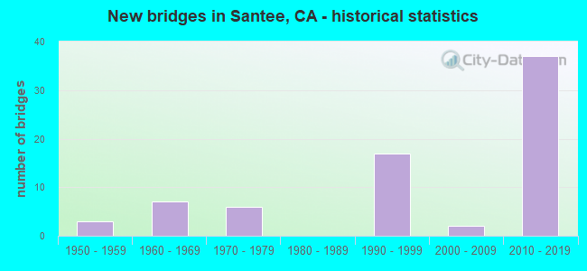
- New bridges - historical statistics
- 31950-1959
- 71960-1969
- 61970-1979
- 171990-1999
- 22000-2009
- 372010-2019

- Reconstructed bridges - Historical Statistics
- 31970-1979
- 11980-1989
- 01990-1999
- 12000-2009


- Bridge Condition - Deck
- 23.5%Good
- 70.6%Fair
- 5.9%Poor

- Bridge Condition - Superstructure
- 85.3%Good
- 14.7%Fair

- Bridge Condition - Substructure
- 91.2%Good
- 8.8%Fair

- Bridge Condition - Channel
- 29.4%Excellent
- 41.2%Very good
- 23.5%Good
- 5.9%Satisfactory

- Bridge Condition - Culverts
- 80.0%Good
- 20.0%Satisfactory
Find on map >> Show street view
Structure Number: 57 0427L, Location: 11-SD-067-R2.67-SNT (Lat: 32.841539, Lng: -116.961528), Route carried "on" structure: State highway 67, Year Built: 1963, Status: Open, Structure Length: 3.29m (10.79ft), Average Daily Traffic: 27,500 (year 2020), Truck Traffic: 4%, Average Future Daily Traffic: 41,080 (year 2040), Design Load: HS 20, Features Intersected: WOODSIDE AVE
Minimum Vertical Clearance: 99.90m (327.76ft), Kilometerpoint: 2.670, Lanes on structure: 2, Lanes under structure: 2, Base Highway Network: Yes (, Subroute: 1), Owner: State Highway Agency, Approaching Roadway Width: 12.1m (39.7ft), Material/Design: Concrete continuous, Design/Construction: Tee Beam, Number Of Spans In Main Unit: 3, Length of Maximum Span: 13.4m (44.0ft), Curb-To-Curb Width: 11.3m (37.1ft), Out-to-Out Width: 12.1m (39.7ft)
Condition: Deck: Good, Superstructure: Good, Substructure: Good, Operating Rating: 34.3 metric tons, Method Used To Determine Operating Rating: Load and Resistance Factor Rating (LRFR) rating reported by rating factor(RF) method using HL-93 loadings, Inventory Rating: 24.3 metric tons, Method Used To Determine Inventory Rating: Load and Resistance Factor Rating (LRFR) rating reported by rating factor(RF) method using HL-93 loadings, Structural Evaluation: Equal to present minimum criteria, Deck Geometry: Somewhat better than minimum adequacy, Underclear: High priority of corrective action, Approach Roadway Alignment: Equal to present desirable criteria, Designated Inspection Frequency: Every 24 months, Inspection Date: September 2020, Deck Structure Type: Concrete Cast-file-Place, Wearing Surface/Protective System: Wearing Surface: Bituminous
Find on map >> Show street view
Structure Number: 57 0427R, Location: 11-SD-067-R2.67-SNT (Lat: 32.841447, Lng: -116.961228), Route carried "on" structure: State highway 67, Year Built: 1963, Status: Open, Structure Length: 3.29m (10.79ft), Average Daily Traffic: 27,500 (year 2020), Truck Traffic: 4%, Average Future Daily Traffic: 41,080 (year 2040), Design Load: HS 20, Features Intersected: WOODSIDE AVE
Minimum Vertical Clearance: 30+ m (98+ ft), Kilometerpoint: 2.670, Lanes on structure: 2, Lanes under structure: 2, Base Highway Network: Yes (, Subroute: 1), Owner: State Highway Agency, Approaching Roadway Width: 12.2m (40.0ft), Material/Design: Concrete continuous, Design/Construction: Tee Beam, Number Of Spans In Main Unit: 3, Length of Maximum Span: 13.4m (44.0ft), Curb-To-Curb Width: 11.4m (37.4ft), Out-to-Out Width: 12.2m (40.0ft)
Condition: Deck: Good, Superstructure: Good, Substructure: Good, Operating Rating: 34.3 metric tons, Method Used To Determine Operating Rating: Load and Resistance Factor Rating (LRFR) rating reported by rating factor(RF) method using HL-93 loadings, Inventory Rating: 24.3 metric tons, Method Used To Determine Inventory Rating: Load and Resistance Factor Rating (LRFR) rating reported by rating factor(RF) method using HL-93 loadings, Structural Evaluation: Equal to present minimum criteria, Deck Geometry: Somewhat better than minimum adequacy, Underclear: High priority of corrective action, Approach Roadway Alignment: Equal to present desirable criteria, Designated Inspection Frequency: Every 24 months, Inspection Date: September 2020, Deck Structure Type: Concrete Cast-file-Place, Wearing Surface/Protective System: Wearing Surface: Bituminous
Find on map >> Show street view
Structure Number: 57 0461, Location: 11-SD-067-R1.94-SNT (Lat: 32.830975, Lng: -116.962236), Route carried "on" structure: County highway S424, Year Built: 1963, Year Reconstructed: 1981, Status: Open, Structure Length: 6.25m (20.51ft), Average Daily Traffic: 19,700 (year 2020), Truck Traffic: 4%, Average Future Daily Traffic: 25,000 (year 2040), Design Load: HS 20, Features Intersected: STATE ROUTE 67, Facility Carried by Structure: PROSPECT AVE
Minimum Vertical Clearance: 99.90m (327.76ft), Kilometerpoint: 0.000, Lanes on structure: 5, Lanes under structure: 4, Owner: State Highway Agency, Approaching Roadway Width: 18.0m (59.1ft), Material/Design: Concrete continuous, Design/Construction: Box Beam or Girders - Multiple, Number Of Spans In Main Unit: 2, Length of Maximum Span: 33.8m (110.9ft), Curb-To-Curb Width: 17.2m (56.4ft), Out-to-Out Width: 18.0m (59.1ft)
Condition: Deck: Good, Superstructure: Good, Substructure: Good, Operating Rating: 99.5 metric tons, Method Used To Determine Operating Rating: Load Factor (LF), Inventory Rating: 32.4 metric tons, Method Used To Determine Inventory Rating: Load Factor (LF), Structural Evaluation: Better than present minimum criteria, Deck Geometry: High priority of replacement, Underclear: High priority of corrective action, Approach Roadway Alignment: Equal to present desirable criteria, Designated Inspection Frequency: Every 24 months, Inspection Date: August 2020, Deck Structure Type: Concrete Cast-file-Place
Find on map >> Show street view
Structure Number: 57 0983L, Location: 11-SD-052-13.80-SNT (Lat: 32.839422, Lng: -117.023067), Route carried "on" structure: State highway 52, Year Built: 1993, Status: Open, Structure Length: 63.25m (207.51ft), Average Daily Traffic: 42,000 (year 2019), Truck Traffic: 3%, Average Future Daily Traffic: 54,883 (year 2043), Design Load: HS 20+Mod, Features Intersected: MAST BL, SAN DIEGO RIVER
Minimum Vertical Clearance: 30+ m (98+ ft), Kilometerpoint: 13.800, Lanes on structure: 2, Lanes under structure: 4, Base Highway Network: Yes (, Subroute: 1), Owner: State Highway Agency, Approaching Roadway Width: 13.1m (43.0ft), Skew: 9 degrees, Material/Design: Prestressed concrete continuous, Design/Construction: Box Beam or Girders - Single/Spread, Number Of Spans In Main Unit: 11, Length of Maximum Span: 68.6m (225.1ft), Curb-To-Curb Width: 12.0m (39.4ft), Out-to-Out Width: 13.0m (42.7ft)
Condition: Deck: Good, Superstructure: Good, Substructure: Good, Channel: Excellent, Operating Rating: 54.1 metric tons, Method Used To Determine Operating Rating: Assigned rating based on Load Factor Design (LFD) reported in metric tons, Inventory Rating: 32.4 metric tons, Method Used To Determine Inventory Rating: Assigned rating based on Load Factor Design (LFD) reported in metric tons, Structural Evaluation: Better than present minimum criteria, Deck Geometry: Equal to present minimum criteria, Underclear: Equal to present minimum criteria, Waterway Adequacy: Superior to present desirable criteria, Approach Roadway Alignment: Better than present minimum criteria, Designated Inspection Frequency: Every 24 months, Inspection Date: March 2021, Deck Structure Type: Concrete Cast-file-Place
Find on map >> Show street view
Structure Number: 57 0983R, Location: 11-SD-052-13.80-SNT (Lat: 32.838886, Lng: -117.023169), Route carried "on" structure: State highway 52, Year Built: 1993, Status: Open, Structure Length: 54.83m (179.89ft), Average Daily Traffic: 42,000 (year 2019), Truck Traffic: 3%, Average Future Daily Traffic: 54,883 (year 2043), Design Load: HS 20+Mod, Features Intersected: MAST BL, SAN DIEGO RIVER
Minimum Vertical Clearance: 30+ m (98+ ft), Kilometerpoint: 13.800, Lanes on structure: 2, Lanes under structure: 4, Base Highway Network: Yes (, Subroute: 1), Owner: State Highway Agency, Approaching Roadway Width: 13.1m (43.0ft), Skew: 9 degrees, Material/Design: Prestressed concrete continuous, Design/Construction: Box Beam or Girders - Single/Spread, Number Of Spans In Main Unit: 10, Length of Maximum Span: 68.6m (225.1ft), Curb-To-Curb Width: 12.0m (39.4ft), Out-to-Out Width: 13.0m (42.7ft)
Condition: Deck: Poor, Superstructure: Good, Substructure: Good, Channel: Excellent, Operating Rating: 54.1 metric tons, Method Used To Determine Operating Rating: Assigned rating based on Load Factor Design (LFD) reported in metric tons, Inventory Rating: 32.4 metric tons, Method Used To Determine Inventory Rating: Assigned rating based on Load Factor Design (LFD) reported in metric tons, Structural Evaluation: Better than present minimum criteria, Deck Geometry: Equal to present minimum criteria, Underclear: Equal to present minimum criteria, Waterway Adequacy: Superior to present desirable criteria, Approach Roadway Alignment: Equal to present desirable criteria, Designated Inspection Frequency: Every 24 months, Inspection Date: March 2021, Deck Structure Type: Concrete Cast-file-Place
Find on map >> Show street view
Structure Number: 57 1024G, Location: 11-SD-052-15.05-SNT (Lat: 32.833239, Lng: -117.003678), Route carried "on" structure: Ramp State highway 52, Year Built: 1998, Status: Open, Structure Length: 4.27m (14.01ft), Average Daily Traffic: 20,700 (year 2010), Truck Traffic: 1%, Average Future Daily Traffic: 32,930 (year 2043), Design Load: HS 20+Mod, Features Intersected: PROSPECT AVENUE
Minimum Vertical Clearance: 30+ m (98+ ft), Kilometerpoint: 15.050, Lanes on structure: 2, Lanes under structure: 2, Base Highway Network: Yes, Owner: State Highway Agency, Approaching Roadway Width: 11.9m (39.0ft), Material/Design: Prestressed concrete, Design/Construction: Box Beam or Girders - Multiple, Number Of Spans In Main Unit: 1, Length of Maximum Span: 42.7m (140.1ft), Curb-To-Curb Width: 11.9m (39.0ft), Out-to-Out Width: 13.0m (42.7ft)
Condition: Deck: Fair, Superstructure: Good, Substructure: Fair, Operating Rating: 54.1 metric tons, Method Used To Determine Operating Rating: Assigned rating based on Load Factor Design (LFD) reported in metric tons, Inventory Rating: 32.4 metric tons, Method Used To Determine Inventory Rating: Assigned rating based on Load Factor Design (LFD) reported in metric tons, Structural Evaluation: Somewhat better than minimum adequacy, Deck Geometry: Superior to present desirable criteria, Underclear: Equal to present minimum criteria, Approach Roadway Alignment: Equal to present desirable criteria, Designated Inspection Frequency: Every 24 months, Inspection Date: March 2021, Deck Structure Type: Concrete Cast-file-Place
Find on map >> Show street view
Structure Number: 57 1024L, Location: 11-SD-125-21.92-SNT (Lat: 32.833056, Lng: -117.003347), Route carried "on" structure: State highway 125, Year Built: 1998, Status: Open, Structure Length: 4.88m (16.01ft), Average Daily Traffic: 19,500 (year 2010), Truck Traffic: 1%, Average Future Daily Traffic: 32,279 (year 2042), Design Load: HS 20, Features Intersected: PROSPECT AVENUE
Minimum Vertical Clearance: 30+ m (98+ ft), Kilometerpoint: 21.920, Lanes on structure: 3, Lanes under structure: 2, Base Highway Network: Yes (Inventory Route: 1, Subroute: 1), Owner: State Highway Agency, Approaching Roadway Width: 17.1m (56.1ft), Skew: 1 degrees, Material/Design: Prestressed concrete, Design/Construction: Box Beam or Girders - Multiple, Number Of Spans In Main Unit: 1, Length of Maximum Span: 48.8m (160.1ft), Curb-To-Curb Width: 17.1m (56.1ft), Out-to-Out Width: 18.1m (59.4ft)
Condition: Deck: Fair, Superstructure: Good, Substructure: Good, Operating Rating: 54.1 metric tons, Method Used To Determine Operating Rating: Assigned rating based on Load Factor Design (LFD) reported in metric tons, Inventory Rating: 32.4 metric tons, Method Used To Determine Inventory Rating: Assigned rating based on Load Factor Design (LFD) reported in metric tons, Structural Evaluation: Better than present minimum criteria, Deck Geometry: Equal to present minimum criteria, Underclear: Equal to present minimum criteria, Approach Roadway Alignment: Equal to present desirable criteria, Designated Inspection Frequency: Every 24 months, Inspection Date: August 2020, Deck Structure Type: Concrete Cast-file-Place
Find on map >> Show street view
Structure Number: 57 1024R, Location: 11-SD-125-21.92-SNT (Lat: 32.833117, Lng: -117.003033), Route carried "on" structure: State highway 125, Year Built: 1998, Status: Open, Structure Length: 4.88m (16.01ft), Average Daily Traffic: 19,500 (year 2010), Truck Traffic: 1%, Average Future Daily Traffic: 32,279 (year 2042), Design Load: HS 20, Features Intersected: PROSPECT AVENUE
Minimum Vertical Clearance: 30+ m (98+ ft), Kilometerpoint: 21.920, Lanes on structure: 3, Lanes under structure: 2, Base Highway Network: Yes (Inventory Route: 1, Subroute: 1), Owner: State Highway Agency, Approaching Roadway Width: 17.1m (56.1ft), Skew: 1 degrees, Material/Design: Prestressed concrete, Design/Construction: Box Beam or Girders - Multiple, Number Of Spans In Main Unit: 1, Length of Maximum Span: 48.8m (160.1ft), Curb-To-Curb Width: 17.1m (56.1ft), Out-to-Out Width: 18.1m (59.4ft)
Condition: Deck: Fair, Superstructure: Good, Substructure: Good, Operating Rating: 54.1 metric tons, Method Used To Determine Operating Rating: Assigned rating based on Load Factor Design (LFD) reported in metric tons, Inventory Rating: 32.4 metric tons, Method Used To Determine Inventory Rating: Assigned rating based on Load Factor Design (LFD) reported in metric tons, Structural Evaluation: Better than present minimum criteria, Deck Geometry: Equal to present minimum criteria, Underclear: Equal to present minimum criteria, Approach Roadway Alignment: Equal to present desirable criteria, Designated Inspection Frequency: Every 24 months, Inspection Date: August 2020, Deck Structure Type: Concrete Cast-file-Place
Find on map >> Show street view
Structure Number: 57 1025F, Location: 11-SD-125-22.09-SNT (Lat: 32.834772, Lng: -117.002794), Route carried "on" structure: Ramp State highway 125, Year Built: 1998, Status: Open, Structure Length: 40.65m (133.37ft), Average Daily Traffic: 1,000 (year 2010), Truck Traffic: 3%, Average Future Daily Traffic: 3,765 (year 2042), Design Load: HS 20, Features Intersected: SR 125, MISSION GORGE RD
Minimum Vertical Clearance: 30+ m (98+ ft), Kilometerpoint: 22.090, Lanes on structure: 2, Lanes under structure: 11, Owner: State Highway Agency, Approaching Roadway Width: 11.9m (39.0ft), Material/Design: Prestressed concrete continuous, Design/Construction: Box Beam or Girders - Multiple, Number Of Spans In Main Unit: 10, Length of Maximum Span: 50.7m (166.3ft), Curb-To-Curb Width: 11.9m (39.0ft), Out-to-Out Width: 12.9m (42.3ft)
Condition: Deck: Fair, Superstructure: Good, Substructure: Good, Operating Rating: 54.1 metric tons, Method Used To Determine Operating Rating: Assigned rating based on Load Factor Design (LFD) reported in metric tons, Inventory Rating: 32.4 metric tons, Method Used To Determine Inventory Rating: Assigned rating based on Load Factor Design (LFD) reported in metric tons, Structural Evaluation: Better than present minimum criteria, Deck Geometry: Superior to present desirable criteria, Underclear: Somewhat better than minimum adequacy, Approach Roadway Alignment: Equal to present desirable criteria, Designated Inspection Frequency: Every 24 months, Inspection Date: August 2020, Deck Structure Type: Concrete Cast-file-Place
Find on map >> Show street view
Structure Number: 57 1026G, Location: 11-SD-052-14.59-SNT (Lat: 32.836314, Lng: -117.005897), Route carried "on" structure: Ramp State highway 52, Year Built: 1998, Status: Open, Structure Length: 7.41m (24.31ft), Average Daily Traffic: 20,700 (year 2010), Truck Traffic: 1%, Average Future Daily Traffic: 32,930 (year 2043), Design Load: HS 20+Mod, Features Intersected: MISSION GORGE RD
Minimum Vertical Clearance: 30+ m (98+ ft), Kilometerpoint: 14.590, Lanes on structure: 2, Lanes under structure: 4, Base Highway Network: Yes, Owner: State Highway Agency, Approaching Roadway Width: 11.9m (39.0ft), Material/Design: Prestressed concrete continuous, Design/Construction: Box Beam or Girders - Multiple, Number Of Spans In Main Unit: 2, Length of Maximum Span: 40.3m (132.2ft), Curb-To-Curb Width: 11.9m (39.0ft), Out-to-Out Width: 13.0m (42.7ft)
Condition: Deck: Fair, Superstructure: Good, Substructure: Good, Operating Rating: 54.1 metric tons, Method Used To Determine Operating Rating: Assigned rating based on Load Factor Design (LFD) reported in metric tons, Inventory Rating: 32.4 metric tons, Method Used To Determine Inventory Rating: Assigned rating based on Load Factor Design (LFD) reported in metric tons, Structural Evaluation: Better than present minimum criteria, Deck Geometry: Superior to present desirable criteria, Underclear: High priority of corrective action, Approach Roadway Alignment: Equal to present desirable criteria, Designated Inspection Frequency: Every 24 months, Inspection Date: March 2021, Deck Structure Type: Concrete Cast-file-Place
Find on map >> Show street view
Structure Number: 57 1092, Location: 11-SD-000-0.00 (Lat: 32.773561, Lng: -117.046269), Route carried "on" structure: City street , Year Built: 2006, Status: Open, Structure Length: 2.50m (8.20ft), Average Daily Traffic: 19,200 (year 2009), Truck Traffic: 4%, Average Future Daily Traffic: 26,018 (year 2036), Design Load: HS 20+Mod, Features Intersected: MTDB LRT & SDIV RR, Facility Carried by Structure: 70TH STREET
Minimum Vertical Clearance: 30+ m (98+ ft), Kilometerpoint: 0.000, Lanes on structure: 5, Owner: State Highway Agency, Approaching Roadway Width: 27.8m (91.2ft), Material/Design: Prestressed concrete, Design/Construction: Box Beam or Girders - Single/Spread, Number Of Spans In Main Unit: 1, Length of Maximum Span: 25.0m (82.0ft), Curb or Sidewalk Widths: Left: 1.5m (4.9ft), Right: 0.0m, Curb-To-Curb Width: 27.8m (91.2ft), Out-to-Out Width: 30.2m (99.1ft)
Condition: Deck: Good, Superstructure: Good, Substructure: Good, Channel: Excellent, Operating Rating: 54.1 metric tons, Method Used To Determine Operating Rating: Assigned rating based on Load Factor Design (LFD) reported in metric tons, Inventory Rating: 32.4 metric tons, Method Used To Determine Inventory Rating: Assigned rating based on Load Factor Design (LFD) reported in metric tons, Structural Evaluation: Better than present minimum criteria, Deck Geometry: Superior to present desirable criteria, Underclear: High priority of corrective action, Waterway Adequacy: Superior to present desirable criteria, Approach Roadway Alignment: Equal to present desirable criteria, Designated Inspection Frequency: Every 48 months, Inspection Date: April 2018, Deck Structure Type: Concrete Cast-file-Place
Find on map >> Show street view
Structure Number: 57 1095L, Location: 11-SD-052-14.93 (Lat: 32.836814, Lng: -117.005489), Route carried "on" structure: State highway 52, Year Built: 2011, Status: Open, Structure Length: 7.45m (24.44ft), Average Daily Traffic: 41,000 (year 2019), Truck Traffic: 3%, Average Future Daily Traffic: 69,775 (year 2043), Design Load: HS 20+Mod, Features Intersected: MISSION GORGE ROAD
Minimum Vertical Clearance: 30+ m (98+ ft), Kilometerpoint: 14.930, Lanes on structure: 2, Lanes under structure: 4, Base Highway Network: Yes (, Subroute: 1), Owner: State Highway Agency, Approaching Roadway Width: 11.7m (38.4ft), Skew: 3 degrees, Material/Design: Prestressed concrete continuous, Design/Construction: Box Beam or Girders - Multiple, Number Of Spans In Main Unit: 2, Length of Maximum Span: 42.0m (137.8ft), Curb-To-Curb Width: 11.7m (38.4ft), Out-to-Out Width: 12.6m (41.3ft)
Condition: Deck: Fair, Superstructure: Good, Substructure: Good, Operating Rating: 54.1 metric tons, Method Used To Determine Operating Rating: Assigned rating based on Load Factor Design (LFD) reported in metric tons, Inventory Rating: 32.4 metric tons, Method Used To Determine Inventory Rating: Assigned rating based on Load Factor Design (LFD) reported in metric tons, Structural Evaluation: Better than present minimum criteria, Deck Geometry: Equal to present minimum criteria, Underclear: Somewhat better than minimum adequacy, Approach Roadway Alignment: Equal to present desirable criteria, Designated Inspection Frequency: Every 24 months, Inspection Date: March 2021, Deck Structure Type: Concrete Cast-file-Place
Find on map >> Show street view
Structure Number: 57 1095R, Location: 11-SD-052-14.93 (Lat: 32.836594, Lng: -117.005681), Route carried "on" structure: State highway 52, Year Built: 2011, Status: Open, Structure Length: 7.45m (24.44ft), Average Daily Traffic: 41,000 (year 2019), Truck Traffic: 3%, Average Future Daily Traffic: 69,775 (year 2043), Design Load: HS 20+Mod, Features Intersected: MISSION GORGE ROAD
Minimum Vertical Clearance: 30+ m (98+ ft), Kilometerpoint: 14.930, Lanes on structure: 2, Lanes under structure: 4, Base Highway Network: Yes (, Subroute: 1), Owner: State Highway Agency, Approaching Roadway Width: 11.7m (38.4ft), Skew: 3 degrees, Material/Design: Prestressed concrete continuous, Design/Construction: Box Beam or Girders - Multiple, Number Of Spans In Main Unit: 2, Length of Maximum Span: 42.0m (137.8ft), Curb-To-Curb Width: 11.7m (38.4ft), Out-to-Out Width: 12.6m (41.3ft)
Condition: Deck: Fair, Superstructure: Good, Substructure: Good, Operating Rating: 54.1 metric tons, Method Used To Determine Operating Rating: Assigned rating based on Load Factor Design (LFD) reported in metric tons, Inventory Rating: 32.4 metric tons, Method Used To Determine Inventory Rating: Assigned rating based on Load Factor Design (LFD) reported in metric tons, Structural Evaluation: Better than present minimum criteria, Deck Geometry: Equal to present minimum criteria, Underclear: Somewhat better than minimum adequacy, Approach Roadway Alignment: Equal to present desirable criteria, Designated Inspection Frequency: Every 24 months, Inspection Date: March 2021, Deck Structure Type: Concrete Cast-file-Place
Find on map >> Show street view
Structure Number: 57 1096F, Location: 11-SD-052-15.06 (Lat: 32.836967, Lng: -117.003747), Route carried "on" structure: Ramp US 52, Year Built: 2011, Status: Open, Structure Length: 8.22m (26.97ft), Average Daily Traffic: 9,600 (year 2015), Truck Traffic: 3%, Average Future Daily Traffic: 10,123 (year 2041), Design Load: HS 20+Mod, Features Intersected: STATE ROUTE 125
Minimum Vertical Clearance: 30+ m (98+ ft), Kilometerpoint: 15.060, Lanes on structure: 1, Lanes under structure: 7, Owner: State Highway Agency, Approaching Roadway Width: 9.4m (30.8ft), Material/Design: Prestressed concrete continuous, Design/Construction: Box Beam or Girders - Multiple, Number Of Spans In Main Unit: 2, Length of Maximum Span: 45.1m (148.0ft), Curb-To-Curb Width: 9.4m (30.8ft), Out-to-Out Width: 10.3m (33.8ft)
Condition: Deck: Good, Superstructure: Good, Substructure: Fair, Operating Rating: 54.1 metric tons, Method Used To Determine Operating Rating: Assigned rating based on Load Factor Design (LFD) reported in metric tons, Inventory Rating: 32.4 metric tons, Method Used To Determine Inventory Rating: Assigned rating based on Load Factor Design (LFD) reported in metric tons, Structural Evaluation: Somewhat better than minimum adequacy, Deck Geometry: Superior to present desirable criteria, Underclear: Equal to present minimum criteria, Approach Roadway Alignment: Equal to present desirable criteria, Designated Inspection Frequency: Every 24 months, Inspection Date: March 2021, Deck Structure Type: Concrete Cast-file-Place
Find on map >> Show street view
Structure Number: 57 1096L, Location: 11-SD-052-15.06 (Lat: 32.836767, Lng: -117.003742), Route carried "on" structure: State highway 52, Year Built: 2011, Status: Open, Structure Length: 8.15m (26.74ft), Average Daily Traffic: 42,000 (year 2019), Truck Traffic: 3%, Average Future Daily Traffic: 69,775 (year 2043), Design Load: HS 20+Mod, Features Intersected: STATE ROUTE 125
Minimum Vertical Clearance: 30+ m (98+ ft), Kilometerpoint: 15.060, Lanes on structure: 2, Lanes under structure: 7, Base Highway Network: Yes (, Subroute: 1), Owner: State Highway Agency, Approaching Roadway Width: 12.1m (39.7ft), Material/Design: Prestressed concrete continuous, Design/Construction: Box Beam or Girders - Multiple, Number Of Spans In Main Unit: 2, Length of Maximum Span: 44.5m (146.0ft), Curb-To-Curb Width: 12.1m (39.7ft), Out-to-Out Width: 13.0m (42.7ft)
Condition: Deck: Fair, Superstructure: Good, Substructure: Good, Operating Rating: 54.1 metric tons, Method Used To Determine Operating Rating: Assigned rating based on Load Factor Design (LFD) reported in metric tons, Inventory Rating: 32.4 metric tons, Method Used To Determine Inventory Rating: Assigned rating based on Load Factor Design (LFD) reported in metric tons, Structural Evaluation: Better than present minimum criteria, Deck Geometry: Equal to present minimum criteria, Underclear: Equal to present minimum criteria, Approach Roadway Alignment: Equal to present desirable criteria, Designated Inspection Frequency: Every 24 months, Inspection Date: March 2021, Deck Structure Type: Concrete Cast-file-Place
Find on map >> Show street view
Structure Number: 57 1096R, Location: 11-SD-052-15.06 (Lat: 32.836561, Lng: -117.003736), Route carried "on" structure: State highway 52, Year Built: 2011, Status: Open, Structure Length: 8.15m (26.74ft), Average Daily Traffic: 42,000 (year 2019), Truck Traffic: 3%, Average Future Daily Traffic: 69,775 (year 2043), Design Load: HS 20+Mod, Features Intersected: STATE ROUTE 125
Minimum Vertical Clearance: 30+ m (98+ ft), Kilometerpoint: 15.060, Lanes on structure: 2, Lanes under structure: 7, Base Highway Network: Yes (, Subroute: 1), Owner: State Highway Agency, Approaching Roadway Width: 11.7m (38.4ft), Material/Design: Prestressed concrete continuous, Design/Construction: Box Beam or Girders - Multiple, Number Of Spans In Main Unit: 2, Length of Maximum Span: 44.5m (146.0ft), Curb-To-Curb Width: 11.7m (38.4ft), Out-to-Out Width: 13.0m (42.7ft)
Condition: Deck: Fair, Superstructure: Good, Substructure: Good, Operating Rating: 54.1 metric tons, Method Used To Determine Operating Rating: Assigned rating based on Load Factor Design (LFD) reported in metric tons, Inventory Rating: 32.4 metric tons, Method Used To Determine Inventory Rating: Assigned rating based on Load Factor Design (LFD) reported in metric tons, Structural Evaluation: Better than present minimum criteria, Deck Geometry: Equal to present minimum criteria, Underclear: Equal to present minimum criteria, Approach Roadway Alignment: Equal to present desirable criteria, Designated Inspection Frequency: Every 24 months, Inspection Date: March 2021, Deck Structure Type: Concrete Cast-file-Place
Find on map >> Show street view
Structure Number: 57 1098, Location: 11-SD-052-15.23 (Lat: 32.836611, Lng: -117.001014), Route carried "on" structure: State highway 52, Year Built: 2011, Status: Open, Structure Length: 4.92m (16.14ft), Average Daily Traffic: 82,000 (year 2019), Truck Traffic: 3%, Average Future Daily Traffic: 139,550 (year 2043), Design Load: HS 20+Mod, Features Intersected: FANITA DRIVE
Minimum Vertical Clearance: 30+ m (98+ ft), Kilometerpoint: 15.230, Lanes on structure: 5, Lanes under structure: 4, Base Highway Network: Yes (, Subroute: 1), Owner: State Highway Agency, Approaching Roadway Width: 30.0m (98.4ft), Skew: 30 degrees, Material/Design: Prestressed concrete, Design/Construction: Box Beam or Girders - Multiple, Number Of Spans In Main Unit: 1, Length of Maximum Span: 49.2m (161.4ft), Curb-To-Curb Width: 30.0m (98.4ft), Out-to-Out Width: 31.5m (103.3ft)
Condition: Deck: Fair, Superstructure: Good, Substructure: Good, Operating Rating: 54.1 metric tons, Method Used To Determine Operating Rating: Assigned rating based on Load Factor Design (LFD) reported in metric tons, Inventory Rating: 32.4 metric tons, Method Used To Determine Inventory Rating: Assigned rating based on Load Factor Design (LFD) reported in metric tons, Structural Evaluation: Better than present minimum criteria, Deck Geometry: Superior to present desirable criteria, Underclear: Somewhat better than minimum adequacy, Approach Roadway Alignment: Equal to present desirable criteria, Designated Inspection Frequency: Every 24 months, Inspection Date: March 2021, Deck Structure Type: Concrete Cast-file-Place
Find on map >> Show street view
Structure Number: 57 1098S, Location: 11-SD-125-22.50-SNT (Lat: 32.836228, Lng: -117.000978), Route carried "on" structure: Ramp State highway 125, Year Built: 2011, Status: Open, Structure Length: 4.56m (14.96ft), Average Daily Traffic: 1,000 (year 2010), Truck Traffic: 3%, Average Future Daily Traffic: 3,643 (year 2042), Design Load: HS 20, Features Intersected: FANITA DRIVE
Minimum Vertical Clearance: 30+ m (98+ ft), Kilometerpoint: 22.500, Lanes on structure: 2, Lanes under structure: 4, Owner: State Highway Agency, Approaching Roadway Width: 11.7m (38.4ft), Skew: 9 degrees, Material/Design: Prestressed concrete, Design/Construction: Box Beam or Girders - Multiple, Number Of Spans In Main Unit: 1, Length of Maximum Span: 45.6m (149.6ft), Curb-To-Curb Width: 11.7m (38.4ft), Out-to-Out Width: 12.6m (41.3ft)
Condition: Deck: Fair, Superstructure: Good, Substructure: Good, Operating Rating: 54.1 metric tons, Method Used To Determine Operating Rating: Assigned rating based on Load Factor Design (LFD) reported in metric tons, Inventory Rating: 32.4 metric tons, Method Used To Determine Inventory Rating: Assigned rating based on Load Factor Design (LFD) reported in metric tons, Structural Evaluation: Better than present minimum criteria, Deck Geometry: Superior to present desirable criteria, Underclear: Somewhat better than minimum adequacy, Approach Roadway Alignment: Superior to present desirable criteria, Designated Inspection Frequency: Every 24 months, Inspection Date: August 2020, Deck Structure Type: Concrete Cast-file-Place
Find on map >> Show street view
Structure Number: 57 11, Location: 11-SD-052-15.59 (Lat: 32.836556, Lng: -116.994564), Route carried "on" structure: State highway 52, Year Built: 2011, Status: Open, Structure Length: 14.25m (46.75ft), Average Daily Traffic: 82,000 (year 2019), Average Future Daily Traffic: 139,550 (year 2043), Design Load: HS 20+Mod, Features Intersected: FORESTER CREEK
Minimum Vertical Clearance: 30+ m (98+ ft), Kilometerpoint: 15.590, Lanes on structure: 6, Base Highway Network: Yes (, Subroute: 1), Owner: State Highway Agency, Approaching Roadway Width: 33.8m (110.9ft), Skew: 35 degrees, Material/Design: Prestressed concrete continuous, Design/Construction: Box Beam or Girders - Multiple, Number Of Spans In Main Unit: 3, Length of Maximum Span: 55.5m (182.1ft), Curb-To-Curb Width: 33.8m (110.9ft), Out-to-Out Width: 35.3m (115.8ft)
Condition: Deck: Fair, Superstructure: Good, Substructure: Good, Channel: Very good, Operating Rating: 54.1 metric tons, Method Used To Determine Operating Rating: Assigned rating based on Load Factor Design (LFD) reported in metric tons, Inventory Rating: 32.4 metric tons, Method Used To Determine Inventory Rating: Assigned rating based on Load Factor Design (LFD) reported in metric tons, Structural Evaluation: Better than present minimum criteria, Deck Geometry: Superior to present desirable criteria, Waterway Adequacy: Superior to present desirable criteria, Approach Roadway Alignment: Equal to present desirable criteria, Designated Inspection Frequency: Every 24 months, Inspection Date: March 2021, Deck Structure Type: Concrete Cast-file-Place
Find on map >> Show street view
Structure Number: 57 1103, Location: 11-SD-052-16.28 (Lat: 32.832981, Lng: -116.983739), Route carried "on" structure: State highway 52, Year Built: 2011, Status: Open, Structure Length: 4.50m (14.76ft), Average Daily Traffic: 82,000 (year 2019), Truck Traffic: 5%, Average Future Daily Traffic: 229,033 (year 2043), Design Load: HS 20+Mod, Features Intersected: CUYAMACA STREET
Minimum Vertical Clearance: 30+ m (98+ ft), Kilometerpoint: 16.280, Lanes on structure: 4, Lanes under structure: 8, Base Highway Network: Yes (, Subroute: 1), Owner: State Highway Agency, Approaching Roadway Width: 26.4m (86.6ft), Skew: 30 degrees, Material/Design: Prestressed concrete, Design/Construction: Box Beam or Girders - Multiple, Number Of Spans In Main Unit: 1, Length of Maximum Span: 45.0m (147.6ft), Curb-To-Curb Width: 26.4m (86.6ft), Out-to-Out Width: 27.9m (91.5ft)
Condition: Deck: Fair, Superstructure: Good, Substructure: Good, Operating Rating: 54.1 metric tons, Method Used To Determine Operating Rating: Assigned rating based on Load Factor Design (LFD) reported in metric tons, Inventory Rating: 32.4 metric tons, Method Used To Determine Inventory Rating: Assigned rating based on Load Factor Design (LFD) reported in metric tons, Structural Evaluation: Better than present minimum criteria, Deck Geometry: Superior to present desirable criteria, Underclear: Somewhat better than minimum adequacy, Approach Roadway Alignment: Equal to present desirable criteria, Designated Inspection Frequency: Every 24 months, Inspection Date: March 2021, Deck Structure Type: Concrete Cast-file-Place
Find on map >> Show street view
Structure Number: 57 1103K, Location: 11-SD-052-16.28 (Lat: 32.833211, Lng: -116.983733), Route carried "on" structure: Ramp US 52, Year Built: 2011, Status: Open, Structure Length: 4.48m (14.70ft), Average Daily Traffic: 9,000 (year 2016), Truck Traffic: 4%, Average Future Daily Traffic: 10,408 (year 2043), Design Load: HS 20+Mod, Features Intersected: CUYAMACA STREET
Minimum Vertical Clearance: 30+ m (98+ ft), Kilometerpoint: 16.280, Lanes on structure: 2, Lanes under structure: 8, Base Highway Network: Yes, Owner: State Highway Agency, Approaching Roadway Width: 10.8m (35.4ft), Material/Design: Prestressed concrete, Design/Construction: Box Beam or Girders - Multiple, Number Of Spans In Main Unit: 1, Length of Maximum Span: 44.8m (147.0ft), Curb-To-Curb Width: 10.8m (35.4ft), Out-to-Out Width: 11.7m (38.4ft)
Condition: Deck: Fair, Superstructure: Good, Substructure: Good, Operating Rating: 54.1 metric tons, Method Used To Determine Operating Rating: Assigned rating based on Load Factor Design (LFD) reported in metric tons, Inventory Rating: 32.4 metric tons, Method Used To Determine Inventory Rating: Assigned rating based on Load Factor Design (LFD) reported in metric tons, Structural Evaluation: Better than present minimum criteria, Deck Geometry: Better than present minimum criteria, Underclear: Somewhat better than minimum adequacy, Approach Roadway Alignment: Equal to present desirable criteria, Designated Inspection Frequency: Every 24 months, Inspection Date: March 2021, Deck Structure Type: Concrete Cast-file-Place
Find on map >> Show street view
Structure Number: 57 1119, Location: 11-SD-052-16.88 (Lat: 32.832803, Lng: -116.973697), Route carried "on" structure: State highway 52, Year Built: 2011, Status: Open, Structure Length: 3.36m (11.02ft), Average Daily Traffic: 78,000 (year 2019), Average Future Daily Traffic: 139,550 (year 2043), Design Load: HS 20+Mod, Features Intersected: COTTONWOOD AVENUE
Minimum Vertical Clearance: 30+ m (98+ ft), Kilometerpoint: 16.880, Lanes on structure: 6, Lanes under structure: 2, Base Highway Network: Yes (, Subroute: 1), Owner: State Highway Agency, Approaching Roadway Width: 33.6m (110.2ft), Skew: 30 degrees, Material/Design: Prestressed concrete, Design/Construction: Box Beam or Girders - Multiple, Number Of Spans In Main Unit: 1, Length of Maximum Span: 33.6m (110.2ft), Curb-To-Curb Width: 33.6m (110.2ft), Out-to-Out Width: 35.3m (115.8ft)
Condition: Deck: Fair, Superstructure: Good, Substructure: Good, Operating Rating: 54.1 metric tons, Method Used To Determine Operating Rating: Assigned rating based on Load Factor Design (LFD) reported in metric tons, Inventory Rating: 32.4 metric tons, Method Used To Determine Inventory Rating: Assigned rating based on Load Factor Design (LFD) reported in metric tons, Structural Evaluation: Better than present minimum criteria, Deck Geometry: Superior to present desirable criteria, Underclear: Somewhat better than minimum adequacy, Approach Roadway Alignment: Equal to present desirable criteria, Designated Inspection Frequency: Every 24 months, Inspection Date: March 2021, Deck Structure Type: Concrete Cast-file-Place
Find on map >> Show street view
Structure Number: 57 1120G, Location: 11-SD-052-17.27-SNT (Lat: 32.831553, Lng: -116.962992), Route carried "on" structure: Ramp US 52, Year Built: 2011, Status: Open, Structure Length: 48.05m (157.64ft), Average Daily Traffic: 19,600 (year 2019), Truck Traffic: 4%, Average Future Daily Traffic: 22,000 (year 2041), Design Load: HS 20+Mod, Features Intersected: MAGNOLIA AVENUE
Minimum Vertical Clearance: 30+ m (98+ ft), Kilometerpoint: 17.270, Lanes on structure: 2, Lanes under structure: 9, Base Highway Network: Yes (, Subroute: 1), Owner: State Highway Agency, Approaching Roadway Width: 11.7m (38.4ft), Skew: 9 degrees, Material/Design: Prestressed concrete continuous, Design/Construction: Box Beam or Girders - Multiple, Number Of Spans In Main Unit: 10, Length of Maximum Span: 58.5m (191.9ft), Curb-To-Curb Width: 11.7m (38.4ft), Out-to-Out Width: 12.6m (41.3ft)
Condition: Deck: Fair, Superstructure: Good, Substructure: Good, Operating Rating: 54.1 metric tons, Method Used To Determine Operating Rating: Assigned rating based on Load Factor Design (LFD) reported in metric tons, Inventory Rating: 32.4 metric tons, Method Used To Determine Inventory Rating: Assigned rating based on Load Factor Design (LFD) reported in metric tons, Structural Evaluation: Better than present minimum criteria, Deck Geometry: Superior to present desirable criteria, Underclear: Somewhat better than minimum adequacy, Approach Roadway Alignment: Equal to present desirable criteria, Designated Inspection Frequency: Every 24 months, Inspection Date: March 2021, Deck Structure Type: Concrete Cast-file-Place
Find on map >> Show street view
Structure Number: 57 1121G, Location: 11-SD-052-17.27 (Lat: 32.832603, Lng: -116.963464), Route carried "on" structure: Ramp State highway 52, Year Built: 2011, Status: Open, Structure Length: 52.55m (172.41ft), Average Daily Traffic: 14,300 (year 2019), Truck Traffic: 2%, Average Future Daily Traffic: 16,000 (year 2041), Design Load: HS 20+Mod, Features Intersected: MAGNOLIA AVE
Minimum Vertical Clearance: 30+ m (98+ ft), Kilometerpoint: 17.270, Lanes on structure: 2, Lanes under structure: 7, Base Highway Network: Yes (, Subroute: 1), Owner: State Highway Agency, Approaching Roadway Width: 11.7m (38.4ft), Skew: 9 degrees, Material/Design: Prestressed concrete continuous, Design/Construction: Box Beam or Girders - Multiple, Number Of Spans In Main Unit: 10, Length of Maximum Span: 57.0m (187.0ft), Curb-To-Curb Width: 11.7m (38.4ft), Out-to-Out Width: 12.6m (41.3ft)
Condition: Deck: Fair, Superstructure: Good, Substructure: Good, Operating Rating: 54.1 metric tons, Method Used To Determine Operating Rating: Assigned rating based on Load Factor Design (LFD) reported in metric tons, Inventory Rating: 32.4 metric tons, Method Used To Determine Inventory Rating: Assigned rating based on Load Factor Design (LFD) reported in metric tons, Structural Evaluation: Better than present minimum criteria, Deck Geometry: Superior to present desirable criteria, Underclear: Meets minimum limits, Approach Roadway Alignment: Equal to present desirable criteria, Designated Inspection Frequency: Every 24 months, Inspection Date: March 2021, Deck Structure Type: Concrete Cast-file-Place
Find on map >> Show street view
Structure Number: 57 1122G, Location: 11-SD-067-R1.80-SNT (Lat: 32.829297, Lng: -116.961581), Route carried "on" structure: Bypass State highway 67, Year Built: 2011, Status: Open, Structure Length: 56.70m (186.02ft), Average Daily Traffic: 15,000 (year 2020), Truck Traffic: 5%, Average Future Daily Traffic: 20,000 (year 2040), Design Load: HS 20, Features Intersected: SR-67, PROSPECT, MAGNOL
Minimum Vertical Clearance: 5.10m (16.73ft), Kilometerpoint: 1.800, Lanes on structure: 2, Lanes under structure: 15, Base Highway Network: Yes (, Subroute: 1), Owner: State Highway Agency, Approaching Roadway Width: 11.7m (38.4ft), Skew: 9 degrees, Material/Design: Prestressed concrete continuous, Design/Construction: Box Beam or Girders - Multiple, Number Of Spans In Main Unit: 11, Length of Maximum Span: 54.2m (177.8ft), Curb-To-Curb Width: 11.7m (38.4ft), Out-to-Out Width: 12.6m (41.3ft)
Condition: Deck: Good, Superstructure: Good, Substructure: Good, Operating Rating: 54.1 metric tons, Method Used To Determine Operating Rating: Assigned rating based on Load Factor Design (LFD) reported in metric tons, Inventory Rating: 32.4 metric tons, Method Used To Determine Inventory Rating: Assigned rating based on Load Factor Design (LFD) reported in metric tons, Structural Evaluation: Better than present minimum criteria, Deck Geometry: Equal to present minimum criteria, Underclear: Equal to present minimum criteria, Approach Roadway Alignment: Superior to present desirable criteria, Designated Inspection Frequency: Every 24 months, Inspection Date: August 2020, Deck Structure Type: Concrete Cast-file-Place
Find on map >> Show street view
Structure Number: 57 1123F, Location: 11-SD-067-R2.05-SNT (Lat: 32.832706, Lng: -116.964658), Route carried "on" structure: Ramp State highway 67, Year Built: 2011, Status: Open, Structure Length: 41.65m (136.65ft), Average Daily Traffic: 15,000 (year 2018), Truck Traffic: 7%, Average Future Daily Traffic: 25,000 (year 2040), Design Load: HS 20, Features Intersected: MAGNOLIA & S67 ONRAMP
Minimum Vertical Clearance: 30+ m (98+ ft), Kilometerpoint: 2.050, Lanes on structure: 2, Lanes under structure: 7, Base Highway Network: Yes (, Subroute: 1), Owner: State Highway Agency, Approaching Roadway Width: 11.7m (38.4ft), Material/Design: Prestressed concrete continuous, Design/Construction: Box Beam or Girders - Multiple, Number Of Spans In Main Unit: 9, Length of Maximum Span: 48.5m (159.1ft), Curb-To-Curb Width: 11.7m (38.4ft), Out-to-Out Width: 12.6m (41.3ft)
Condition: Deck: Fair, Superstructure: Good, Substructure: Good, Operating Rating: 54.1 metric tons, Method Used To Determine Operating Rating: Assigned rating based on Load Factor Design (LFD) reported in metric tons, Inventory Rating: 32.4 metric tons, Method Used To Determine Inventory Rating: Assigned rating based on Load Factor Design (LFD) reported in metric tons, Structural Evaluation: Better than present minimum criteria, Deck Geometry: Superior to present desirable criteria, Underclear: Superior to present desirable criteria, Approach Roadway Alignment: Superior to present desirable criteria, Designated Inspection Frequency: Every 24 months, Inspection Date: September 2020, Deck Structure Type: Concrete Cast-file-Place
Find on map >> Show street view
Structure Number: 57 1132, Location: 11-SD-052-15.10 (Lat: 32.836583, Lng: -117.002703), Route carried "on" structure: State highway 52, Year Built: 2011, Status: Open, Structure Length: 0.73m (2.40ft), Average Daily Traffic: 61,000 (year 2009), Truck Traffic: 3%, Average Future Daily Traffic: 134,087 (year 2037), Features Intersected: FANITA CREEK
Minimum Vertical Clearance: 30+ m (98+ ft), Kilometerpoint: 15.100, Lanes on structure: 4, Base Highway Network: Yes (, Subroute: 1), Owner: State Highway Agency, Approaching Roadway Width: 31.5m (103.3ft), Skew: 30 degrees, Material/Design: Concrete, Design/Construction: Culvert, Number Of Spans In Main Unit: 3, Length of Maximum Span: 2.4m (7.9ft)
Condition: Channel: Very good, Culverts: Good, Operating Rating: 54.1 metric tons, Method Used To Determine Operating Rating: Field evaluation and documented engineering judgment, Inventory Rating: 32.4 metric tons, Method Used To Determine Inventory Rating: Field evaluation and documented engineering judgment, Structural Evaluation: Better than present minimum criteria, Waterway Adequacy: Equal to present desirable criteria, Approach Roadway Alignment: Equal to present desirable criteria, Designated Inspection Frequency: Every 48 months, Inspection Date: March 2019
Find on map >> Show street view
Structure Number: 57C0165, Location: 600 FT E/O DAIRY MART RD (Lat: 32.558658, Lng: -117.060497), Route carried "on" structure: City street , Year Built: 1955, Year Reconstructed: 1984, Status: Open, Structure Length: 1.58m (5.18ft), Average Daily Traffic: 20,395 (year 2018), Truck Traffic: 3%, Average Future Daily Traffic: 30,082 (year 2040), Design Load: HS 20, Features Intersected: N BRANCH MESA CREEK, Facility Carried by Structure: SAN YSIDRO BLVD
Minimum Vertical Clearance: 30+ m (98+ ft), Kilometerpoint: 0.000, Lanes on structure: 3, Owner: City or Municipal Highway Agency, Approaching Roadway Width: 23.6m (77.4ft), Skew: 2 degrees, Material/Design: Concrete continuous, Design/Construction: Culvert, Number Of Spans In Main Unit: 4, Length of Maximum Span: 3.7m (12.1ft), Curb or Sidewalk Widths: Left: 0.0m, Right: 1.8m (5.9ft), Curb-To-Curb Width: 23.6m (77.4ft), Out-to-Out Width: 28.0m (91.9ft)
Condition: Channel: Very good, Culverts: Good, Operating Rating: 54.1 metric tons, Method Used To Determine Operating Rating: Field evaluation and documented engineering judgment, Inventory Rating: 32.4 metric tons, Method Used To Determine Inventory Rating: Field evaluation and documented engineering judgment, Structural Evaluation: Better than present minimum criteria, Deck Geometry: Superior to present desirable criteria, Waterway Adequacy: Superior to present desirable criteria, Approach Roadway Alignment: Equal to present desirable criteria, Designated Inspection Frequency: Every 48 months, Inspection Date: April 2020
Find on map >> Show street view
Structure Number: 57C0166, Location: 0.7MI W/O CUYAMACA ST (Lat: 32.838522, Lng: -116.997108), Route carried "on" structure: City street , Year Built: 1959, Year Reconstructed: 2008, Status: Open, Structure Length: 6.00m (19.69ft), Average Daily Traffic: 49,474 (year 2016), Truck Traffic: 5%, Average Future Daily Traffic: 57,286 (year 2037), Design Load: HS 20, Features Intersected: FORESTER CREEK, Facility Carried by Structure: MISSION GORGE RD
Minimum Vertical Clearance: 30+ m (98+ ft), Kilometerpoint: 0.000, Lanes on structure: 6, Owner: City or Municipal Highway Agency, Approaching Roadway Width: 27.1m (88.9ft), Skew: 3 degrees, Material/Design: Concrete continuous, Design/Construction: Slab, Number Of Spans In Main Unit: 6, Length of Maximum Span: 12.0m (39.4ft), Curb or Sidewalk Widths: Left: 1.8m (5.9ft), Right: 1.8m (5.9ft), Curb-To-Curb Width: 27.1m (88.9ft), Out-to-Out Width: 31.2m (102.4ft)
Condition: Deck: Fair, Superstructure: Fair, Substructure: Good, Channel: Good, Operating Rating: 64.8 metric tons, Method Used To Determine Operating Rating: Load Factor (LF), Inventory Rating: 39.2 metric tons, Method Used To Determine Inventory Rating: Load Factor (LF), Structural Evaluation: Somewhat better than minimum adequacy, Deck Geometry: Better than present minimum criteria, Waterway Adequacy: Equal to present desirable criteria, Approach Roadway Alignment: Equal to present desirable criteria, Designated Inspection Frequency: Every 24 months, Inspection Date: April 2020, Deck Structure Type: Concrete Cast-file-Place, Wearing Surface/Protective System: Wearing Surface: Bituminous
Find on map >> Show street view
Structure Number: 57C0327, Location: 0.5M N/O MISSION GORGE RD (Lat: 32.845558, Lng: -116.983547), Route carried "on" structure: City street , Year Built: 1974, Status: Open, Structure Length: 15.24m (50.00ft), Average Daily Traffic: 26,648 (year 2016), Truck Traffic: 4%, Average Future Daily Traffic: 32,868 (year 2037), Design Load: HS 20, Features Intersected: SAN DIEGO RIVER, Facility Carried by Structure: CUYAMACA ST.
Minimum Vertical Clearance: 30+ m (98+ ft), Kilometerpoint: 0.000, Lanes on structure: 4, Owner: City or Municipal Highway Agency, Approaching Roadway Width: 19.5m (64.0ft), Skew: 1 degrees, Material/Design: Concrete continuous, Design/Construction: Slab, Number Of Spans In Main Unit: 12, Length of Maximum Span: 12.5m (41.0ft), Curb or Sidewalk Widths: Left: 1.7m (5.6ft), Right: 0.0m, Curb-To-Curb Width: 19.5m (64.0ft), Out-to-Out Width: 21.9m (71.9ft)
Condition: Deck: Fair, Superstructure: Fair, Substructure: Good, Channel: Good, Operating Rating: 84.9 metric tons, Method Used To Determine Operating Rating: Load Factor (LF), Inventory Rating: 51.2 metric tons, Method Used To Determine Inventory Rating: Load Factor (LF), Structural Evaluation: Somewhat better than minimum adequacy, Deck Geometry: Better than present minimum criteria, Waterway Adequacy: Superior to present desirable criteria, Approach Roadway Alignment: Equal to present desirable criteria, Designated Inspection Frequency: Every 24 months, Inspection Date: April 2020, Deck Structure Type: Concrete Cast-file-Place
Find on map >> Show street view
Structure Number: 57C0398, Location: 1.1 MI E OF MAST BLVD. (Lat: 32.843936, Lng: -117.006847), Route carried "on" structure: City street , Year Built: 1960, Year Reconstructed: 1977, Status: Open, Structure Length: 4.33m (14.21ft), Average Daily Traffic: 10,375 (year 2016), Average Future Daily Traffic: 12,595 (year 2037), Features Intersected: SYCAMORE CREEK, Facility Carried by Structure: CARLTON OAKS DR
Minimum Vertical Clearance: 30+ m (98+ ft), Kilometerpoint: 0.000, Lanes on structure: 2, Owner: City or Municipal Highway Agency, Approaching Roadway Width: 19.5m (64.0ft), Material/Design: Prestressed concrete, Design/Construction: Tee Beam, Number Of Spans In Main Unit: 3, Length of Maximum Span: 14.3m (46.9ft), Curb or Sidewalk Widths: Left: 1.4m (4.6ft), Right: 1.4m (4.6ft), Curb-To-Curb Width: 19.5m (64.0ft), Out-to-Out Width: 22.6m (74.1ft)
Condition: Deck: Good, Superstructure: Good, Substructure: Good, Channel: Very good, Operating Rating: 29.2 metric tons, Method Used To Determine Operating Rating: Field evaluation and documented engineering judgment, Inventory Rating: 17.5 metric tons, Method Used To Determine Inventory Rating: Field evaluation and documented engineering judgment, Structural Evaluation: Meets minimum limits, Deck Geometry: Superior to present desirable criteria, Waterway Adequacy: Equal to present minimum criteria, Approach Roadway Alignment: Equal to present desirable criteria, Designated Inspection Frequency: Every 24 months, Inspection Date: April 2020, Deck Structure Type: Concrete Cast-file-Place, Wearing Surface/Protective System: Wearing Surface: Bituminous
Find on map >> Show street view
Structure Number: 57C0417, Location: 0.6M N/O MISSION GORGE RD (Lat: 32.847069, Lng: -116.969319), Route carried "on" structure: City street , Year Built: 1978, Status: Open, Structure Length: 15.24m (50.00ft), Average Daily Traffic: 21,629 (year 2016), Truck Traffic: 4%, Average Future Daily Traffic: 23,070 (year 2037), Design Load: HS 20+Mod, Features Intersected: SAN DIEGO RIVER, Facility Carried by Structure: MAGNOLIA AVE
Minimum Vertical Clearance: 30+ m (98+ ft), Kilometerpoint: 0.000, Lanes on structure: 4, Owner: City or Municipal Highway Agency, Approaching Roadway Width: 21.3m (69.9ft), Material/Design: Concrete continuous, Design/Construction: Slab, Number Of Spans In Main Unit: 12, Length of Maximum Span: 12.5m (41.0ft), Curb or Sidewalk Widths: Left: 1.5m (4.9ft), Right: 0.0m, Curb-To-Curb Width: 19.5m (64.0ft), Out-to-Out Width: 21.9m (71.9ft)
Condition: Deck: Fair, Superstructure: Fair, Substructure: Good, Channel: Good, Operating Rating: 58.3 metric tons, Method Used To Determine Operating Rating: Load Factor (LF), Inventory Rating: 35.0 metric tons, Method Used To Determine Inventory Rating: Load Factor (LF), Structural Evaluation: Somewhat better than minimum adequacy, Deck Geometry: Better than present minimum criteria, Waterway Adequacy: Superior to present desirable criteria, Approach Roadway Alignment: Equal to present desirable criteria, Designated Inspection Frequency: Every 24 months, Inspection Date: April 2020, Deck Structure Type: Concrete Cast-file-Place
Find on map >> Show street view
Structure Number: 57C0523, Location: 0.2MI N/O MISSION GORGE (Lat: 32.842589, Lng: -116.997047), Route carried "on" structure: City street , Year Built: 1978, Status: Open, Structure Length: 15.24m (50.00ft), Average Daily Traffic: 23,227 (year 2016), Truck Traffic: 1%, Average Future Daily Traffic: 25,090 (year 2037), Features Intersected: SAN DIEGO RIVER, Facility Carried by Structure: CARLTON HILL BLVD
Minimum Vertical Clearance: 30+ m (98+ ft), Kilometerpoint: 0.000, Lanes on structure: 5, Owner: City or Municipal Highway Agency, Approaching Roadway Width: 23.2m (76.1ft), Material/Design: Concrete continuous, Design/Construction: Slab, Number Of Spans In Main Unit: 12, Length of Maximum Span: 12.5m (41.0ft), Curb or Sidewalk Widths: Left: 1.5m (4.9ft), Right: 1.5m (4.9ft), Curb-To-Curb Width: 19.5m (64.0ft), Out-to-Out Width: 23.2m (76.1ft)
Condition: Deck: Fair, Superstructure: Fair, Substructure: Good, Channel: Good, Operating Rating: 77.1 metric tons, Method Used To Determine Operating Rating: Load Factor (LF), Inventory Rating: 46.3 metric tons, Method Used To Determine Inventory Rating: Load Factor (LF), Structural Evaluation: Somewhat better than minimum adequacy, Deck Geometry: Meets minimum limits, Waterway Adequacy: Superior to present desirable criteria, Approach Roadway Alignment: Equal to present desirable criteria, Designated Inspection Frequency: Every 24 months, Inspection Date: April 2020, Deck Structure Type: Concrete Cast-file-Place
Find on map >> Show street view
Structure Number: 57C0533, Location: 0.1MI W/O CUYAMACA ST (Lat: 32.831381, Lng: -116.985900), Route carried "on" structure: City street , Year Built: 1970, Year Reconstructed: 1987, Status: Open, Structure Length: 3.60m (11.81ft), Average Daily Traffic: 21,891 (year 2016), Truck Traffic: 6%, Average Future Daily Traffic: 26,235 (year 2042), Design Load: HS 20, Features Intersected: FORESTER CREEK, Facility Carried by Structure: PROSPECT AVE
Minimum Vertical Clearance: 30+ m (98+ ft), Kilometerpoint: 0.000, Lanes on structure: 4, Owner: City or Municipal Highway Agency, Approaching Roadway Width: 20.1m (65.9ft), Skew: 4 degrees, Material/Design: Concrete continuous, Design/Construction: Tee Beam, Number Of Spans In Main Unit: 3, Length of Maximum Span: 14.0m (45.9ft), Curb or Sidewalk Widths: Left: 1.5m (4.9ft), Right: 1.5m (4.9ft), Curb-To-Curb Width: 20.1m (65.9ft), Out-to-Out Width: 23.8m (78.1ft)
Condition: Deck: Poor, Superstructure: Good, Substructure: Good, Channel: Very good, Operating Rating: 61.9 metric tons, Method Used To Determine Operating Rating: Load Factor (LF), Inventory Rating: 37.3 metric tons, Method Used To Determine Inventory Rating: Load Factor (LF), Structural Evaluation: Better than present minimum criteria, Deck Geometry: Better than present minimum criteria, Waterway Adequacy: Superior to present desirable criteria, Approach Roadway Alignment: Equal to present desirable criteria, Designated Inspection Frequency: Every 24 months, Inspection Date: May 2020, Deck Structure Type: Concrete Cast-file-Place
Find on map >> Show street view
Structure Number: 57C0538, Location: 150FT E/O FANITA DR., (Lat: 32.833733, Lng: -117.000103), Route carried "on" structure: City street , Year Built: 1978, Status: Open, Structure Length: 0.73m (2.40ft), Average Daily Traffic: 12,051 (year 2016), Average Future Daily Traffic: 15,900 (year 2037), Features Intersected: FANITA CREEK, Facility Carried by Structure: PROSPECT AVE
Minimum Vertical Clearance: 30+ m (98+ ft), Kilometerpoint: 0.000, Lanes on structure: 2, Owner: City or Municipal Highway Agency, Approaching Roadway Width: 17.0m (55.8ft), Skew: 2 degrees, Material/Design: Concrete, Design/Construction: Culvert, Number Of Spans In Main Unit: 2, Length of Maximum Span: 3.0m (9.8ft), Curb or Sidewalk Widths: Left: 0.3m (1.0ft), Right: 1.5m (4.9ft), Curb-To-Curb Width: 17.0m (55.8ft), Out-to-Out Width: 20.7m (67.9ft)
Condition: Channel: Satisfactory, Culverts: Satisfactory, Operating Rating: 54.1 metric tons, Method Used To Determine Operating Rating: Field evaluation and documented engineering judgment, Inventory Rating: 32.4 metric tons, Method Used To Determine Inventory Rating: Field evaluation and documented engineering judgment, Structural Evaluation: Equal to present minimum criteria, Deck Geometry: Superior to present desirable criteria, Waterway Adequacy: Equal to present desirable criteria, Approach Roadway Alignment: Equal to present desirable criteria, Designated Inspection Frequency: Every 48 months, Inspection Date: April 2020
Find on map >> Show street view
Structure Number: 57C0728, Location: 1MI E/O WEST HILLS PKWY (Lat: 32.849622, Lng: -117.007417), Route carried "on" structure: City street , Year Built: 1992, Status: Open, Structure Length: 25.80m (84.65ft), Average Daily Traffic: 10,100 (year 2016), Truck Traffic: 2%, Average Future Daily Traffic: 12,092 (year 2037), Design Load: HS 20+Mod, Features Intersected: SANTEE LAKE #2, Facility Carried by Structure: MAST BLVD
Minimum Vertical Clearance: 30+ m (98+ ft), Kilometerpoint: 0.000, Lanes on structure: 4, Owner: City or Municipal Highway Agency, Approaching Roadway Width: 25.0m (82.0ft), Skew: 20 degrees, Material/Design: Prestressed concrete continuous, Design/Construction: Box Beam or Girders - Multiple, Number Of Spans In Main Unit: 6, Length of Maximum Span: 43.0m (141.1ft), Curb or Sidewalk Widths: Left: 1.8m (5.9ft), Right: 1.8m (5.9ft), Curb-To-Curb Width: 21.3m (69.9ft), Out-to-Out Width: 29.9m (98.1ft)
Condition: Deck: Fair, Superstructure: Good, Substructure: Fair, Channel: Very good, Operating Rating: 54.1 metric tons, Method Used To Determine Operating Rating: Assigned rating based on Load Factor Design (LFD) reported in metric tons, Inventory Rating: 32.4 metric tons, Method Used To Determine Inventory Rating: Assigned rating based on Load Factor Design (LFD) reported in metric tons, Structural Evaluation: Somewhat better than minimum adequacy, Deck Geometry: Superior to present desirable criteria, Waterway Adequacy: Superior to present desirable criteria, Approach Roadway Alignment: Equal to present desirable criteria, Designated Inspection Frequency: Every 24 months, Underwater Inspection Frequency: Every 60 months, Inspection Date: April 2020, Underwater Inspection Date: June 2019, Deck Structure Type: Concrete Cast-file-Place
Find on map >> Show street view
Structure Number: 57C0744M, Location: 120 FT E/O LOS RANCHITOS (Lat: 32.863467, Lng: -116.959278), Route carried "on" structure: City street , Year Built: 1971, Status: Open, Structure Length: 1.00m (3.28ft), Average Daily Traffic: 6,300 (year 2019), Truck Traffic: 1%, Average Future Daily Traffic: 6,700 (year 2041), Features Intersected: STORM DRAIN, Facility Carried by Structure: EL NOPAL
Minimum Vertical Clearance: 30+ m (98+ ft), Kilometerpoint: 0.000, Lanes on structure: 2, Owner: County Highway Agency, Approaching Roadway Width: 13.8m (45.3ft), Material/Design: Concrete continuous, Design/Construction: Culvert, Number Of Spans In Main Unit: 5, Length of Maximum Span: 1.8m (5.9ft), Curb or Sidewalk Widths: Left: 1.5m (4.9ft), Right: 1.5m (4.9ft), Curb-To-Curb Width: 13.8m (45.3ft), Out-to-Out Width: 15.8m (51.8ft)
Condition: Channel: Excellent, Culverts: Good, Operating Rating: 40.5 metric tons, Method Used To Determine Operating Rating: Field evaluation and documented engineering judgment, Inventory Rating: 24.3 metric tons, Method Used To Determine Inventory Rating: Field evaluation and documented engineering judgment, Structural Evaluation: Equal to present minimum criteria, Deck Geometry: Superior to present desirable criteria, Waterway Adequacy: Equal to present desirable criteria, Approach Roadway Alignment: Equal to present desirable criteria, Designated Inspection Frequency: Every 24 months, Inspection Date: September 2021, Deck Structure Type: Concrete Cast-file-Place, Wearing Surface/Protective System: Wearing Surface: Bituminous
Find on map >> Show street view
Structure Number: 57C0801, Location: 1.6M N/O SR 76 (Lat: 33.351700, Lng: -117.159831), Route carried "on" structure: County highway , Year Built: 1950, Status: Open, Structure Length: 0.82m (2.69ft), Average Daily Traffic: 250 (year 2016), Truck Traffic: 2%, Average Future Daily Traffic: 358 (year 2038), Features Intersected: SAN LUIS REY TRIBUTARY, Facility Carried by Structure: OLD HIGHWAY 395
Minimum Vertical Clearance: 30+ m (98+ ft), Kilometerpoint: 0.000, Lanes on structure: 2, Owner: County Highway Agency, Approaching Roadway Width: 12.4m (40.7ft), Skew: 3 degrees, Material/Design: Concrete, Design/Construction: Culvert, Number Of Spans In Main Unit: 2, Length of Maximum Span: 3.6m (11.8ft)
Condition: Channel: Very good, Culverts: Good, Operating Rating: 54.1 metric tons, Method Used To Determine Operating Rating: Field evaluation and documented engineering judgment, Inventory Rating: 32.4 metric tons, Method Used To Determine Inventory Rating: Field evaluation and documented engineering judgment, Structural Evaluation: Better than present minimum criteria, Waterway Adequacy: Equal to present desirable criteria, Approach Roadway Alignment: Equal to present desirable criteria, Designated Inspection Frequency: Every 48 months, Inspection Date: August 2019
Find on map >> Show street view
Structure Number: 57C0809, Location: 40FT N/O PROSPECT AVE (Lat: 32.833678, Lng: -116.989167), Route carried "on" structure: City street , Year Built: 2008, Status: Open, Structure Length: 6.34m (20.80ft), Average Daily Traffic: 1,400 (year 2016), Truck Traffic: 1%, Average Future Daily Traffic: 2,346 (year 2042), Design Load: HS 20+Mod, Features Intersected: FORESTER CREEK, Facility Carried by Structure: OLIVE LANE
Minimum Vertical Clearance: 30+ m (98+ ft), Kilometerpoint: 0.000, Lanes on structure: 5, Owner: City or Municipal Highway Agency, Approaching Roadway Width: 21.0m (68.9ft), Material/Design: Concrete continuous, Design/Construction: Slab, Number Of Spans In Main Unit: 4, Length of Maximum Span: 17.7m (58.1ft), Curb or Sidewalk Widths: Left: 1.7m (5.6ft), Right: 1.7m (5.6ft), Curb-To-Curb Width: 21.3m (69.9ft), Out-to-Out Width: 26.1m (85.6ft)
Condition: Deck: Fair, Superstructure: Fair, Substructure: Good, Channel: Excellent, Operating Rating: 54.1 metric tons, Method Used To Determine Operating Rating: Assigned rating based on Load Factor Design (LFD) reported in metric tons, Inventory Rating: 32.4 metric tons, Method Used To Determine Inventory Rating: Assigned rating based on Load Factor Design (LFD) reported in metric tons, Structural Evaluation: Somewhat better than minimum adequacy, Deck Geometry: Somewhat better than minimum adequacy, Waterway Adequacy: Equal to present desirable criteria, Approach Roadway Alignment: Equal to present desirable criteria, Designated Inspection Frequency: Every 24 months, Inspection Date: May 2020, Deck Structure Type: Concrete Cast-file-Place
Find on map >> Show street view
Structure Number: 57 0427L, Location: 11-SD-067-R2.67-SNT (Lat: 32.841539, Lng: -116.961528), Route carried "under" structure: County highway S300, Year Built: 1963, Structure Length: 0. m, Average Daily Traffic: 14,400 (year 2010), Truck Traffic: 2%, Features Intersected: WOODSIDE AVE, Facility Carried by Structure: STATE ROUTE 67 SB
Minimum Vertical Clearance: 6.00m (19.69ft), Kilometerpoint: 0.000, Lanes on structure: 2, Lanes under structure: 2, Material/Design: Concrete continuous, Design/Construction: Tee Beam, Length of Maximum Span: 13.4m (44.0ft)
Find on map >> Show street view
Structure Number: 57 0427R, Location: 11-SD-067-R2.67-SNT (Lat: 32.841447, Lng: -116.961228), Route carried "under" structure: County highway S300, Year Built: 1963, Structure Length: 0. m, Average Daily Traffic: 14,400 (year 2020), Truck Traffic: 2%, Features Intersected: WOODSIDE AVE, Facility Carried by Structure: STATE ROUTE 67 NB
Minimum Vertical Clearance: 5.05m (16.57ft), Kilometerpoint: 0.000, Lanes on structure: 2, Lanes under structure: 2, Material/Design: Concrete continuous, Design/Construction: Tee Beam, Length of Maximum Span: 13.4m (44.0ft)
Find on map >> Show street view
Structure Number: 57 0461, Location: 11-SD-067-R1.94-SNT (Lat: 32.830975, Lng: -116.962236), Route carried "under" structure: State highway 67, Year Built: 1963, Structure Length: 0. m, Average Daily Traffic: 80,000 (year 2018), Truck Traffic: 7%, Features Intersected: STATE ROUTE 67, Facility Carried by Structure: PROSPECT AVE
Minimum Vertical Clearance: 4.50m (14.76ft), Kilometerpoint: 1.940, Lanes on structure: 5, Lanes under structure: 4, Material/Design: Concrete continuous, Design/Construction: Box Beam or Girders - Multiple, Length of Maximum Span: 33.8m (110.9ft)
Find on map >> Show street view
Structure Number: 57 0983L, Location: 11-SD-052-13.80-SNT (Lat: 32.839422, Lng: -117.023067), Route carried "under" structure: City street , Year Built: 1993, Structure Length: 0. m, Average Daily Traffic: 10,700 (year 2015), Truck Traffic: 1%, Features Intersected: MAST BL, SAN DIEGO RIVER, Facility Carried by Structure: STATE ROUTE 52 WB
Minimum Vertical Clearance: 5.84m (19.16ft), Kilometerpoint: 0.000, Lanes on structure: 2, Lanes under structure: 4, Material/Design: Prestressed concrete continuous, Design/Construction: Box Beam or Girders - Single/Spread, Length of Maximum Span: 68.6m (225.1ft)