Bridge Statistics for San Rafael, California (CA)
Condition, Traffic, Stress, Structural Evaluation, Project Costs
- National Bridge Inventory (NBI) Statistics
- 55Number of bridges
- 2,096ft / 639mTotal length
- $2,970,000Total costs
- 2,696,767Total average daily traffic
- 61,682Total average daily truck traffic
- National Bridge Inventory (NBI) Registered Bridges for San Rafael
- No street view available for this location
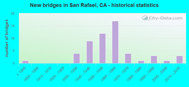
- New bridges - historical statistics
- 1Before 1900
- 41930-1939
- 91940-1949
- 121950-1959
- 171960-1969
- 41970-1979
- 11980-1989
- 31990-1999
- 12000-2009
- 32010-2019

- Reconstructed bridges - Historical Statistics
- 11940-1949
- 11950-1959
- 31960-1969
- 01970-1979
- 31980-1989
- 11990-1999
- 22000-2009
- 12010-2019


- Bridge Condition - Deck
- 62.5%Good
- 12.5%Satisfactory
- 20.8%Fair
- 4.2%Poor

- Bridge Condition - Superstructure
- 75.0%Good
- 12.5%Satisfactory
- 8.3%Fair
- 4.2%Poor

- Bridge Condition - Substructure
- 83.3%Good
- 8.3%Fair
- 8.3%Poor

- Bridge Condition - Channel
- 13.6%Excellent
- 36.4%Very good
- 18.2%Good
- 22.7%Satisfactory
- 4.5%Fair
- 4.5%Serious

- Bridge Condition - Culverts
- 71.4%Good
- 28.6%Satisfactory
Find on map >> Show street view
Structure Number: 27 0006, Location: 04-MRN-101-13.99-SRF (Lat: 38.011153, Lng: -122.541769), Route carried "on" structure: US 101, Year Built: 1951, Year Reconstructed: 1961, Status: Open, Structure Length: 1.31m (4.30ft), Average Daily Traffic: 159,000 (year 2009), Truck Traffic: 4%, Average Future Daily Traffic: 235,301 (year 2043), Features Intersected: N BRANCH GALLINAS CREEK
Minimum Vertical Clearance: 30+ m (98+ ft), Kilometerpoint: 13.990, Lanes on structure: 10, Base Highway Network: Yes (Inventory Route: 1, Subroute: 1), Owner: State Highway Agency, Approaching Roadway Width: 46.4m (152.2ft), Skew: 3 degrees, Material/Design: Concrete continuous, Design/Construction: Culvert, Number Of Spans In Main Unit: 3, Length of Maximum Span: 4.0m (13.1ft), Curb-To-Curb Width: 46.4m (152.2ft), Out-to-Out Width: 48.0m (157.5ft)
Condition: Channel: Good, Culverts: Satisfactory, Operating Rating: 54.1 metric tons, Method Used To Determine Operating Rating: Field evaluation and documented engineering judgment, Inventory Rating: 32.4 metric tons, Method Used To Determine Inventory Rating: Field evaluation and documented engineering judgment, Structural Evaluation: Equal to present minimum criteria, Deck Geometry: Superior to present desirable criteria, Waterway Adequacy: Superior to present desirable criteria, Approach Roadway Alignment: Equal to present desirable criteria, Designated Inspection Frequency: Every 48 months, Inspection Date: March 2021, Deck Structure Type: Concrete Cast-file-Place, Wearing Surface/Protective System: Wearing Surface: Bituminous
Find on map >> Show street view
Structure Number: 27 0007, Location: 04-MRN-101-9.63-SRF (Lat: 37.957081, Lng: -122.508731), Route carried "on" structure: US 101, Year Built: 1958, Year Reconstructed: 2003, Status: Open, Structure Length: 31.21m (102.40ft), Average Daily Traffic: 172,000 (year 2009), Truck Traffic: 2%, Average Future Daily Traffic: 225,945 (year 2042), Design Load: HS 20, Features Intersected: GGT, BELLAM, ANDERSEN
Minimum Vertical Clearance: 30+ m (98+ ft), Kilometerpoint: 9.630, Lanes on structure: 8, Lanes under structure: 9, Base Highway Network: Yes (Inventory Route: 1, Subroute: 1), Owner: State Highway Agency, Approaching Roadway Width: 35.7m (117.1ft), Skew: 39 degrees, Material/Design: Concrete continuous, Design/Construction: Box Beam or Girders - Multiple, Number Of Spans In Main Unit: 12, Length of Maximum Span: 32.9m (107.9ft), Curb-To-Curb Width: 35.7m (117.1ft), Out-to-Out Width: 37.4m (122.7ft)
Condition: Deck: Good, Superstructure: Good, Substructure: Good, Operating Rating: 67.1 metric tons, Method Used To Determine Operating Rating: Load Factor (LF), Inventory Rating: 40.5 metric tons, Method Used To Determine Inventory Rating: Load Factor (LF), Structural Evaluation: Better than present minimum criteria, Deck Geometry: Better than present minimum criteria, Underclear: Meets minimum limits, Approach Roadway Alignment: Equal to present desirable criteria, Designated Inspection Frequency: Every 24 months, Inspection Date: May 2020, Deck Structure Type: Concrete Cast-file-Place, Wearing Surface/Protective System: Wearing Surface: Integral Concrete
Find on map >> Show street view
Structure Number: 27 001, Location: 04-MRN-101-4.03-SAUS (Lat: 37.879025, Lng: -122.515044), Route carried "on" structure: US 101, Year Built: 1957, Year Reconstructed: 1973, Status: Open, Structure Length: 87.29m (286.38ft), Average Daily Traffic: 133,000 (year 2009), Truck Traffic: 2%, Average Future Daily Traffic: 174,220 (year 2042), Design Load: HS 20, Features Intersected: SR 1, RICH BY, FRNTGE RD
Minimum Vertical Clearance: 30+ m (98+ ft), Kilometerpoint: 4.030, Lanes on structure: 10, Lanes under structure: 5, Base Highway Network: Yes (Inventory Route: 1, Subroute: 1), Owner: State Highway Agency, Approaching Roadway Width: 41.0m (134.5ft), Skew: 39 degrees, Navigation Control: Yes ( Vertical Clearance: 12.8m (42.0ft), Horizontal Clearance: 17.1m (56.1ft)), Material/Design: Prestressed concrete, Design/Construction: Stringer/Multi-beam, Number Of Spans In Main Unit: 21, Number Of Approach Spans: 23, Length of Maximum Span: 24.4m (80.1ft), Curb-To-Curb Width: 41.0m (134.5ft), Out-to-Out Width: 42.2m (138.5ft)
Condition: Deck: Fair, Superstructure: Good, Substructure: Good, Channel: Good, Operating Rating: 40.2 metric tons, Method Used To Determine Operating Rating: Load Factor (LF), Inventory Rating: 30.6 metric tons, Method Used To Determine Inventory Rating: Load Factor (LF), Structural Evaluation: Better than present minimum criteria, Deck Geometry: Meets minimum limits, Underclear: High priority of corrective action, Waterway Adequacy: Superior to present desirable criteria, Approach Roadway Alignment: Better than present minimum criteria, Designated Inspection Frequency: Every 24 months, Underwater Inspection Frequency: Every 60 months, Inspection Date: May 2020, Underwater Inspection Date: August 2017, Deck Structure Type: Concrete Cast-file-Place, Wearing Surface/Protective System: Wearing Surface: Bituminous
Find on map >> Show street view
Structure Number: 27 0014, Location: 04-MRN-101-12.69-SRF (Lat: 37.994014, Lng: -122.531797), Route carried "on" structure: US 101, Year Built: 1979, Year Reconstructed: 1987, Status: Open, Structure Length: 5.33m (17.49ft), Average Daily Traffic: 180,000 (year 2009), Average Future Daily Traffic: 262,761 (year 2041), Design Load: HS 20+Mod, Features Intersected: NORTH SAN PEDRO ROAD
Minimum Vertical Clearance: 30+ m (98+ ft), Kilometerpoint: 12.690, Lanes on structure: 10, Lanes under structure: 3, Base Highway Network: Yes (Inventory Route: 1, Subroute: 1), Owner: State Highway Agency, Approaching Roadway Width: 36.9m (121.1ft), Skew: 31 degrees, Material/Design: Prestressed concrete continuous, Design/Construction: Box Beam or Girders - Multiple, Number Of Spans In Main Unit: 2, Length of Maximum Span: 26.5m (86.9ft), Curb or Sidewalk Widths: Left: 0.2m (0.7ft), Right: 0.2m (0.7ft), Curb-To-Curb Width: 44.4m (145.7ft), Out-to-Out Width: 46.1m (151.2ft)
Condition: Deck: Satisfactory, Superstructure: Good, Substructure: Good, Operating Rating: 54.1 metric tons, Method Used To Determine Operating Rating: Assigned rating based on Load Factor Design (LFD) reported in metric tons, Inventory Rating: 32.4 metric tons, Method Used To Determine Inventory Rating: Assigned rating based on Load Factor Design (LFD) reported in metric tons, Structural Evaluation: Better than present minimum criteria, Deck Geometry: Superior to present desirable criteria, Underclear: Meets minimum limits, Approach Roadway Alignment: Equal to present desirable criteria, Designated Inspection Frequency: Every 48 months, Inspection Date: March 2021, Deck Structure Type: Concrete Cast-file-Place, Wearing Surface/Protective System: Wearing Surface: Bituminous
Find on map >> Show street view
Structure Number: 27 0014S, Location: 04-MRN-101-12.69-SRF (Lat: 37.994036, Lng: -122.531636), Route carried "on" structure: Ramp US 101, Year Built: 1970, Status: Open, Structure Length: 5.09m (16.70ft), Average Daily Traffic: 3,300 (year 2001), Truck Traffic: 1%, Average Future Daily Traffic: 10,582 (year 2037), Design Load: HS 20+Mod, Features Intersected: NORTH SAN PEDRO ROAD
Minimum Vertical Clearance: 30+ m (98+ ft), Kilometerpoint: 12.690, Lanes on structure: 1, Lanes under structure: 3, Owner: State Highway Agency, Approaching Roadway Width: 7.6m (24.9ft), Skew: 1 degrees, Material/Design: Concrete continuous, Design/Construction: Box Beam or Girders - Multiple, Number Of Spans In Main Unit: 2, Length of Maximum Span: 25.9m (85.0ft), Curb-To-Curb Width: 7.3m (24.0ft), Out-to-Out Width: 8.2m (26.9ft)
Condition: Deck: Good, Superstructure: Good, Substructure: Good, Operating Rating: 43.4 metric tons, Method Used To Determine Operating Rating: Load and Resistance Factor Rating (LRFR) rating reported by rating factor(RF) method using HL-93 loadings, Inventory Rating: 32.1 metric tons, Method Used To Determine Inventory Rating: Load and Resistance Factor Rating (LRFR) rating reported by rating factor(RF) method using HL-93 loadings, Structural Evaluation: Better than present minimum criteria, Deck Geometry: Better than present minimum criteria, Underclear: High priority of corrective action, Approach Roadway Alignment: Equal to present desirable criteria, Designated Inspection Frequency: Every 48 months, Inspection Date: March 2019, Deck Structure Type: Concrete Cast-file-Place
Find on map >> Show street view
Structure Number: 27 0033S, Location: 04-MRN-101-10.81-SRF (Lat: 37.969828, Lng: -122.521128), Route carried "on" structure: Bypass US 101, Year Built: 1941, Year Reconstructed: 1953, Status: Open, Structure Length: 2.53m (8.30ft), Average Daily Traffic: 16,400 (year 1998), Truck Traffic: 1%, Average Future Daily Traffic: 66,520 (year 2042), Design Load: HS 20, Features Intersected: S RAFAEL HARB (IRWIN ST)
Minimum Vertical Clearance: 30+ m (98+ ft), Kilometerpoint: 10.810, Lanes on structure: 3, Base Highway Network: Yes (Inventory Route: 1, Subroute: 1), Owner: State Highway Agency, Approaching Roadway Width: 11.6m (38.1ft), Material/Design: Concrete continuous, Design/Construction: Slab, Number Of Spans In Main Unit: 6, Length of Maximum Span: 24.4m (80.1ft), Curb or Sidewalk Widths: Left: 2.7m (8.9ft), Right: 2.9m (9.5ft), Curb-To-Curb Width: 11.5m (37.7ft), Out-to-Out Width: 18.1m (59.4ft)
Condition: Deck: Poor, Superstructure: Poor, Substructure: Poor, Channel: Satisfactory, Operating Rating: 62.9 metric tons, Method Used To Determine Operating Rating: Load Factor (LF), Inventory Rating: 37.9 metric tons, Method Used To Determine Inventory Rating: Load Factor (LF), Structural Evaluation: Meets minimum limits, Deck Geometry: High priority of replacement, Waterway Adequacy: Equal to present desirable criteria, Approach Roadway Alignment: Better than present minimum criteria, Length Of Structure Improvement: 2.53m (8.30ft), Designated Inspection Frequency: Every 24 months, Inspection Date: May 2020, Bridge Improvement Cost: $1,467,000, Roadway Improvement Cost: $293,000, Total Project Cost: $2,465,000 ( Estimate for 2017), Deck Structure Type: Concrete Cast-file-Place, Wearing Surface/Protective System: Wearing Surface: Bituminous
Find on map >> Show street view
Structure Number: 27 0034, Location: 04-MRN-101-11.64-SRF (Lat: 37.981306, Lng: -122.521444), Route carried "on" structure: US 101, Year Built: 1947, Year Reconstructed: 2009, Status: Open, Structure Length: 1.52m (4.99ft), Average Daily Traffic: 173,000 (year 2009), Average Future Daily Traffic: 249,155 (year 2038), Design Load: HS 20+Mod, Features Intersected: LINDEN LANE
Minimum Vertical Clearance: 30+ m (98+ ft), Kilometerpoint: 11.640, Lanes on structure: 9, Lanes under structure: 2, Base Highway Network: Yes (Inventory Route: 1, Subroute: 1), Owner: State Highway Agency, Approaching Roadway Width: 20.9m (68.6ft), Skew: 33 degrees, Material/Design: Concrete, Design/Construction: Slab, Number Of Spans In Main Unit: 1, Length of Maximum Span: 11.0m (36.1ft), Curb-To-Curb Width: 34.9m (114.5ft), Out-to-Out Width: 38.4m (126.0ft)
Condition: Deck: Good, Superstructure: Good, Substructure: Good, Operating Rating: 53.5 metric tons, Method Used To Determine Operating Rating: Load Factor (LF), Inventory Rating: 32.1 metric tons, Method Used To Determine Inventory Rating: Load Factor (LF), Structural Evaluation: Better than present minimum criteria, Deck Geometry: Meets minimum limits, Underclear: High priority of corrective action, Approach Roadway Alignment: Equal to present desirable criteria, Designated Inspection Frequency: Every 48 months, Inspection Date: March 2019, Deck Structure Type: Concrete Cast-file-Place, Wearing Surface/Protective System: Wearing Surface: Bituminous
Find on map >> Show street view
Structure Number: 27 0035L, Location: 04-MRN-101-10.72-SRF (Lat: 37.968758, Lng: -122.520867), Route carried "on" structure: US 101, Year Built: 1965, Year Reconstructed: 1971, Status: Open, Structure Length: 85.16m (279.40ft), Average Daily Traffic: 64,500 (year 2009), Average Future Daily Traffic: 90,272 (year 2040), Design Load: HS 20, Features Intersected: 2ND, 3RD, 4TH, 5TH, MSSN
Minimum Vertical Clearance: 30+ m (98+ ft), Kilometerpoint: 10.720, Lanes on structure: 4, Lanes under structure: 16, Base Highway Network: Yes (Inventory Route: 1, Subroute: 1), Owner: State Highway Agency, Approaching Roadway Width: 21.3m (69.9ft), Skew: 1 degrees, Material/Design: Concrete continuous, Design/Construction: Box Beam or Girders - Multiple, Number Of Spans In Main Unit: 22, Number Of Approach Spans: 22, Length of Maximum Span: 33.5m (109.9ft), Curb-To-Curb Width: 20.1m (65.9ft), Out-to-Out Width: 21.0m (68.9ft)
Condition: Deck: Satisfactory, Superstructure: Satisfactory, Substructure: Good, Channel: Excellent, Operating Rating: 99.8 metric tons, Method Used To Determine Operating Rating: Load Factor (LF), Inventory Rating: 39.2 metric tons, Method Used To Determine Inventory Rating: Load Factor (LF), Structural Evaluation: Equal to present minimum criteria, Deck Geometry: Equal to present minimum criteria, Underclear: High priority of corrective action, Waterway Adequacy: Superior to present desirable criteria, Approach Roadway Alignment: Better than present minimum criteria, Designated Inspection Frequency: Every 24 months, Inspection Date: May 2020, Deck Structure Type: Concrete Cast-file-Place
Find on map >> Show street view
Structure Number: 27 0035R, Location: 04-MRN-101-10.72-SRF (Lat: 37.968758, Lng: -122.520606), Route carried "on" structure: US 101, Year Built: 1941, Year Reconstructed: 1971, Status: Open, Structure Length: 67.36m (221.00ft), Average Daily Traffic: 64,500 (year 2009), Average Future Daily Traffic: 90,272 (year 2040), Features Intersected: 2ND, 3RD, 4TH, 5TH, MSSN
Minimum Vertical Clearance: 30+ m (98+ ft), Kilometerpoint: 10.720, Lanes on structure: 3, Lanes under structure: 15, Base Highway Network: Yes (Inventory Route: 1, Subroute: 1), Owner: State Highway Agency, Approaching Roadway Width: 16.8m (55.1ft), Skew: 9 degrees, Material/Design: Concrete continuous, Design/Construction: Tee Beam, Number Of Spans In Main Unit: 37, Number Of Approach Spans: 30, Length of Maximum Span: 17.7m (58.1ft), Curb or Sidewalk Widths: Left: 0.0m, Right: 0.6m (2.0ft), Curb-To-Curb Width: 15.5m (50.9ft), Out-to-Out Width: 16.4m (53.8ft)
Condition: Deck: Fair, Superstructure: Good, Substructure: Good, Channel: Excellent, Operating Rating: 45.0 metric tons, Method Used To Determine Operating Rating: Load Factor (LF), Inventory Rating: 27.2 metric tons, Method Used To Determine Inventory Rating: Load Factor (LF), Structural Evaluation: Equal to present minimum criteria, Deck Geometry: Somewhat better than minimum adequacy, Underclear: High priority of corrective action, Waterway Adequacy: Superior to present desirable criteria, Approach Roadway Alignment: Better than present minimum criteria, Designated Inspection Frequency: Every 24 months, Inspection Date: May 2020, Deck Structure Type: Concrete Cast-file-Place
Find on map >> Show street view
Structure Number: 27 0052, Location: 04-MRN-101-L0.01 (Lat: 37.820000, Lng: -122.476667), Route carried "on" structure: US 101, Year Built: 1937, Status: Open, Structure Length: 274.23m (899.70ft), Average Daily Traffic: 112,000 (year 2016), Truck Traffic: 1%, Average Future Daily Traffic: 118,891 (year 2038), Features Intersected: GOLDEN GATE-SAN FRAN BAY
Minimum Vertical Clearance: 30+ m (98+ ft), Kilometerpoint: 0.010, Lanes on structure: 6, Base Highway Network: Yes (Inventory Route: 1, Subroute: 1), Toll: Toll bridge, Owner: Local Toll Authority, Approaching Roadway Width: 33.5m (109.9ft), Navigation Control: Yes ( Vertical Clearance: 67.1m (220.1ft), Horizontal Clearance: 999.9m (3,280.5ft)), Material/Design: Steel, Design/Construction: Suspension, Number Of Spans In Main Unit: 3, Number Of Approach Spans: 13, Length of Maximum Span: 1280.2m (4,200.1ft), Curb or Sidewalk Widths: Left: 3.0m (9.8ft), Right: 3.0m (9.8ft), Curb-To-Curb Width: 18.9m (62.0ft), Out-to-Out Width: 18.9m (62.0ft)
Condition: Deck: Fair, Superstructure: Fair, Substructure: Good, Channel: Excellent, Operating Rating: 21.4 metric tons, Method Used To Determine Operating Rating: Load and Resistance Factor Rating (LRFR) rating reported by rating factor(RF) method using HL-93 loadings, Inventory Rating: 16.5 metric tons, Method Used To Determine Inventory Rating: Load and Resistance Factor Rating (LRFR) rating reported by rating factor(RF) method using HL-93 loadings, Structural Evaluation: Meets minimum limits, Deck Geometry: High priority of replacement, Waterway Adequacy: Superior to present desirable criteria, Approach Roadway Alignment: Equal to present minimum criteria, Length Of Structure Improvement: 274.23m (899.70ft), Designated Inspection Frequency: Every 24 months, Critical Feature Inspection Frequency: Every 24 months, Underwater Inspection Frequency: Every 60 months, Inspection Date: December 2020, Critical Feature Inspection Date: December 2020, Underwater Inspection Date: August 2019, Bridge Improvement Cost: $151,415,000, Deck Structure Type: Steel plate, Wearing Surface/Protective System: Wearing Surface: Epoxy Overlay
Find on map >> Show street view
Structure Number: 27 0059, Location: 04-MRN-101-14.71-SRF (Lat: 38.020950, Lng: -122.538964), Route carried "on" structure: US 101, Year Built: 1952, Year Reconstructed: 1987, Status: Open, Structure Length: 3.14m (10.30ft), Average Daily Traffic: 151,000 (year 2009), Average Future Daily Traffic: 219,074 (year 2038), Design Load: HS 20+Mod, Features Intersected: LUCAS VALLEY ROAD
Minimum Vertical Clearance: 30+ m (98+ ft), Kilometerpoint: 14.710, Lanes on structure: 10, Lanes under structure: 3, Base Highway Network: Yes (Inventory Route: 1, Subroute: 1), Owner: State Highway Agency, Approaching Roadway Width: 41.8m (137.1ft), Skew: 31 degrees, Material/Design: Concrete continuous, Design/Construction: Slab, Number Of Spans In Main Unit: 3, Length of Maximum Span: 12.2m (40.0ft), Curb-To-Curb Width: 54.4m (178.5ft), Out-to-Out Width: 56.4m (185.0ft)
Condition: Deck: Good, Superstructure: Good, Substructure: Good, Operating Rating: 48.0 metric tons, Method Used To Determine Operating Rating: Load and Resistance Factor Rating (LRFR) rating reported by rating factor(RF) method using HL-93 loadings, Inventory Rating: 34.3 metric tons, Method Used To Determine Inventory Rating: Load and Resistance Factor Rating (LRFR) rating reported by rating factor(RF) method using HL-93 loadings, Structural Evaluation: Better than present minimum criteria, Deck Geometry: Superior to present desirable criteria, Underclear: High priority of corrective action, Approach Roadway Alignment: Equal to present desirable criteria, Designated Inspection Frequency: Every 24 months, Inspection Date: March 2021, Deck Structure Type: Concrete Cast-file-Place, Wearing Surface/Protective System: Wearing Surface: Bituminous
Find on map >> Show street view
Structure Number: 27 0073L, Location: 04-MRN-580-4.50-SRF (Lat: 37.959886, Lng: -122.505394), Route carried "on" structure: Interstate 580, Year Built: 1959, Status: Open, Structure Length: 3.72m (12.20ft), Average Daily Traffic: 33,500 (year 2009), Truck Traffic: 7%, Average Future Daily Traffic: 59,416 (year 2040), Features Intersected: BELLAM BOULEVARD
Minimum Vertical Clearance: 30+ m (98+ ft), Kilometerpoint: 4.500, Lanes on structure: 2, Lanes under structure: 7, Base Highway Network: Yes (Inventory Route: 5, Subroute: 1), Owner: State Highway Agency, Approaching Roadway Width: 11.6m (38.1ft), Material/Design: Concrete continuous, Design/Construction: Box Beam or Girders - Multiple, Number Of Spans In Main Unit: 2, Length of Maximum Span: 18.5m (60.7ft), Curb or Sidewalk Widths: Left: 0.6m (2.0ft), Right: 0.6m (2.0ft), Curb-To-Curb Width: 11.3m (37.1ft), Out-to-Out Width: 12.9m (42.3ft)
Condition: Deck: Good, Superstructure: Satisfactory, Substructure: Good, Operating Rating: 56.7 metric tons, Method Used To Determine Operating Rating: Load and Resistance Factor Rating (LRFR) rating reported by rating factor(RF) method using HL-93 loadings, Inventory Rating: 43.7 metric tons, Method Used To Determine Inventory Rating: Load and Resistance Factor Rating (LRFR) rating reported by rating factor(RF) method using HL-93 loadings, Structural Evaluation: Equal to present minimum criteria, Deck Geometry: Somewhat better than minimum adequacy, Underclear: High priority of corrective action, Approach Roadway Alignment: Equal to present desirable criteria, Designated Inspection Frequency: Every 24 months, Inspection Date: May 2020, Deck Structure Type: Concrete Cast-file-Place, Wearing Surface/Protective System: Wearing Surface: Bituminous
Find on map >> Show street view
Structure Number: 27 0073R, Location: 04-MRN-580-4.50-SRF (Lat: 37.959936, Lng: -122.505200), Route carried "on" structure: Interstate 580, Year Built: 2010, Status: Open, Structure Length: 3.64m (11.94ft), Average Daily Traffic: 33,500 (year 2009), Truck Traffic: 7%, Average Future Daily Traffic: 59,416 (year 2040), Design Load: HL 93, Features Intersected: BELLAM BOULEVARD
Minimum Vertical Clearance: 30+ m (98+ ft), Kilometerpoint: 4.500, Lanes on structure: 2, Lanes under structure: 7, Base Highway Network: Yes (Inventory Route: 5, Subroute: 1), Owner: State Highway Agency, Approaching Roadway Width: 11.6m (38.1ft), Material/Design: Prestressed concrete, Design/Construction: Girder and Floorbeam System, Number Of Spans In Main Unit: 1, Length of Maximum Span: 36.1m (118.4ft), Curb-To-Curb Width: 11.9m (39.0ft), Out-to-Out Width: 12.8m (42.0ft)
Condition: Deck: Good, Superstructure: Good, Substructure: Good, Operating Rating: 42.1 metric tons, Method Used To Determine Operating Rating: Assigned ratings based on Load and Resistance Factor Design (LRFD) reported by rating factor (RF) using HL93 loadings, Inventory Rating: 32.4 metric tons, Method Used To Determine Inventory Rating: Assigned ratings based on Load and Resistance Factor Design (LRFD) reported by rating factor (RF) using HL93 loadings, Structural Evaluation: Better than present minimum criteria, Deck Geometry: Equal to present minimum criteria, Underclear: High priority of corrective action, Approach Roadway Alignment: Equal to present desirable criteria, Designated Inspection Frequency: Every 24 months, Inspection Date: May 2020, Deck Structure Type: Concrete Cast-file-Place
Find on map >> Show street view
Structure Number: 27 0074, Location: 04-MRN-580-3.29-SRF (Lat: 37.946514, Lng: -122.491839), Route carried "on" structure: ServiceCity street , Year Built: 1957, Status: Open, Structure Length: 20.49m (67.22ft), Average Daily Traffic: 34,735 (year 2007), Truck Traffic: 4%, Average Future Daily Traffic: 54,981 (year 2040), Design Load: HS 20, Features Intersected: STATE ROUTE 580, Facility Carried by Structure: SIR FRAN DRAKE BLV
Minimum Vertical Clearance: 30+ m (98+ ft), Kilometerpoint: 0.000, Lanes on structure: 1, Lanes under structure: 4, Owner: State Highway Agency, Approaching Roadway Width: 10.1m (33.1ft), Skew: 9 degrees, Material/Design: Concrete continuous, Design/Construction: Box Beam or Girders - Multiple, Number Of Spans In Main Unit: 4, Number Of Approach Spans: 6, Length of Maximum Span: 32.0m (105.0ft), Curb or Sidewalk Widths: Left: 0.6m (2.0ft), Right: 0.6m (2.0ft), Curb-To-Curb Width: 8.5m (27.9ft), Out-to-Out Width: 10.2m (33.5ft)
Condition: Deck: Good, Superstructure: Good, Substructure: Good, Operating Rating: 36.9 metric tons, Method Used To Determine Operating Rating: Load and Resistance Factor Rating (LRFR) rating reported by rating factor(RF) method using HL-93 loadings, Inventory Rating: 28.5 metric tons, Method Used To Determine Inventory Rating: Load and Resistance Factor Rating (LRFR) rating reported by rating factor(RF) method using HL-93 loadings, Structural Evaluation: Better than present minimum criteria, Deck Geometry: Meets minimum limits, Underclear: High priority of corrective action, Approach Roadway Alignment: Equal to present minimum criteria, Designated Inspection Frequency: Every 24 months, Inspection Date: May 2020, Deck Structure Type: Concrete Cast-file-Place
Find on map >> Show street view
Structure Number: 27 0097, Location: 04-MRN-101-11.20-SRF (Lat: 37.976886, Lng: -122.520264), Route carried "on" structure: US 101, Year Built: 1895, Year Reconstructed: 1987, Status: Open, Structure Length: 6.30m (20.67ft), Average Daily Traffic: 129,000 (year 2009), Average Future Daily Traffic: 179,346 (year 2038), Features Intersected: IRWIN CREEK
Minimum Vertical Clearance: 30+ m (98+ ft), Kilometerpoint: 11.200, Lanes on structure: 9, Base Highway Network: Yes (Inventory Route: 1, Subroute: 1), Owner: State Highway Agency, Approaching Roadway Width: 23.7m (77.8ft), Skew: 23 degrees, Material/Design: Concrete, Design/Construction: Culvert, Number Of Spans In Main Unit: 1, Length of Maximum Span: 4.6m (15.1ft)
Condition: Channel: Good, Culverts: Satisfactory, Operating Rating: 25.9 metric tons, Method Used To Determine Operating Rating: Field evaluation and documented engineering judgment, Inventory Rating: 14.6 metric tons, Method Used To Determine Inventory Rating: Field evaluation and documented engineering judgment, Structural Evaluation: High priority of corrective action, Waterway Adequacy: Equal to present desirable criteria, Approach Roadway Alignment: Equal to present desirable criteria, Designated Inspection Frequency: Every 24 months, Inspection Date: March 2021
Find on map >> Show street view
Structure Number: 27 011, Location: 04-MRN-101-13.50-SRF (Lat: 38.003672, Lng: -122.540442), Route carried "on" structure: City street , Year Built: 1996, Status: Open, Structure Length: 11.48m (37.66ft), Average Daily Traffic: 9,170 (year 1998), Truck Traffic: 2%, Average Future Daily Traffic: 12,921 (year 2041), Design Load: HS 20+Mod, Features Intersected: US 101 & MERRYDALE RD, Facility Carried by Structure: MERRYDALE ROAD
Minimum Vertical Clearance: 30+ m (98+ ft), Kilometerpoint: 0.000, Lanes on structure: 2, Lanes under structure: 10, Owner: State Highway Agency, Approaching Roadway Width: 13.7m (44.9ft), Skew: 29 degrees, Material/Design: Prestressed concrete continuous, Design/Construction: Box Beam or Girders - Multiple, Number Of Spans In Main Unit: 4, Length of Maximum Span: 40.1m (131.6ft), Curb or Sidewalk Widths: Left: 1.5m (4.9ft), Right: 0.0m, Curb-To-Curb Width: 13.7m (44.9ft), Out-to-Out Width: 16.1m (52.8ft)
Condition: Deck: Fair, Superstructure: Good, Substructure: Good, Operating Rating: 54.1 metric tons, Method Used To Determine Operating Rating: Assigned rating based on Load Factor Design (LFD) reported in metric tons, Inventory Rating: 32.4 metric tons, Method Used To Determine Inventory Rating: Assigned rating based on Load Factor Design (LFD) reported in metric tons, Structural Evaluation: Better than present minimum criteria, Deck Geometry: Superior to present desirable criteria, Underclear: High priority of corrective action, Approach Roadway Alignment: Better than present minimum criteria, Designated Inspection Frequency: Every 24 months, Inspection Date: March 2021, Deck Structure Type: Concrete Cast-file-Place
Find on map >> Show street view
Structure Number: 27C0013, Location: 0.87 MI N OF SR 101 (Lat: 38.027014, Lng: -122.552036), Route carried "on" structure: County highway , Year Built: 1959, Status: Open, Structure Length: 2.04m (6.69ft), Average Daily Traffic: 6,500 (year 1975), Truck Traffic: 3%, Average Future Daily Traffic: 7,633 (year 2041), Design Load: HS 20, Features Intersected: MILLER CREEK, Facility Carried by Structure: LUCAS VALLEY RD
Minimum Vertical Clearance: 30+ m (98+ ft), Kilometerpoint: 0.000, Lanes on structure: 2, Base Highway Network: Yes, Owner: County Highway Agency, Approaching Roadway Width: 12.5m (41.0ft), Skew: 2 degrees, Material/Design: Concrete, Design/Construction: Tee Beam, Number Of Spans In Main Unit: 1, Length of Maximum Span: 18.9m (62.0ft), Curb or Sidewalk Widths: Left: 0.0m, Right: 1.2m (3.9ft), Curb-To-Curb Width: 11.2m (36.7ft), Out-to-Out Width: 12.6m (41.3ft)
Condition: Deck: Good, Superstructure: Good, Substructure: Fair, Channel: Fair, Operating Rating: 82.6 metric tons, Method Used To Determine Operating Rating: Load Factor (LF), Inventory Rating: 49.2 metric tons, Method Used To Determine Inventory Rating: Load Factor (LF), Structural Evaluation: Somewhat better than minimum adequacy, Deck Geometry: Meets minimum limits, Waterway Adequacy: Better than present minimum criteria, Approach Roadway Alignment: Equal to present desirable criteria, Designated Inspection Frequency: Every 24 months, Inspection Date: August 2021, Deck Structure Type: Concrete Cast-file-Place, Wearing Surface/Protective System: Wearing Surface: Bituminous
Find on map >> Show street view
Structure Number: 27C0016, Location: 1.7 MI W OF SR 101 (Lat: 38.025214, Lng: -122.567742), Route carried "on" structure: County highway , Year Built: 1961, Status: Open, Structure Length: 4.03m (13.22ft), Average Daily Traffic: 1,000 (year 1975), Truck Traffic: 3%, Average Future Daily Traffic: 3,272 (year 2041), Design Load: HS 20, Features Intersected: MILLER CREEK, Facility Carried by Structure: LUCAS VALLEY ROAD
Minimum Vertical Clearance: 30+ m (98+ ft), Kilometerpoint: 0.000, Lanes on structure: 2, Base Highway Network: Yes, Owner: County Highway Agency, Approaching Roadway Width: 11.3m (37.1ft), Skew: 4 degrees, Material/Design: Concrete continuous, Design/Construction: Slab, Number Of Spans In Main Unit: 4, Length of Maximum Span: 9.8m (32.2ft), Curb-To-Curb Width: 11.3m (37.1ft), Out-to-Out Width: 11.4m (37.4ft)
Condition: Deck: Good, Superstructure: Good, Substructure: Good, Channel: Serious, Operating Rating: 59.0 metric tons, Method Used To Determine Operating Rating: Load Factor (LF), Inventory Rating: 35.3 metric tons, Method Used To Determine Inventory Rating: Load Factor (LF), Structural Evaluation: Better than present minimum criteria, Deck Geometry: Better than present minimum criteria, Waterway Adequacy: Better than present minimum criteria, Approach Roadway Alignment: Equal to present desirable criteria, Designated Inspection Frequency: Every 24 months, Inspection Date: August 2021, Deck Structure Type: Concrete Cast-file-Place, Wearing Surface/Protective System: Wearing Surface: Bituminous
Find on map >> Show street view
Structure Number: 27C0019, Location: 500 FT E OF US HWY 101 (Lat: 37.969119, Lng: -122.519222), Route carried "on" structure: City street , Year Built: 1965, Status: Open, Structure Length: 7.38m (24.21ft), Average Daily Traffic: 19,800 (year 1977), Truck Traffic: 10%, Average Future Daily Traffic: 24,391 (year 2041), Design Load: HS 20+Mod, Features Intersected: SAN RAFAEL CREEK, Facility Carried by Structure: GRAND AVE
Minimum Vertical Clearance: 30+ m (98+ ft), Kilometerpoint: 0.000, Lanes on structure: 3, Owner: City or Municipal Highway Agency, Approaching Roadway Width: 12.2m (40.0ft), Material/Design: Concrete continuous, Design/Construction: Slab, Number Of Spans In Main Unit: 8, Length of Maximum Span: 9.1m (29.9ft), Curb or Sidewalk Widths: Left: 1.0m (3.3ft), Right: 0.0m, Curb-To-Curb Width: 12.2m (40.0ft), Out-to-Out Width: 14.3m (46.9ft)
Condition: Deck: Fair, Superstructure: Fair, Substructure: Good, Channel: Very good, Operating Rating: 63.8 metric tons, Method Used To Determine Operating Rating: Load Factor (LF), Inventory Rating: 38.6 metric tons, Method Used To Determine Inventory Rating: Load Factor (LF), Structural Evaluation: Somewhat better than minimum adequacy, Deck Geometry: Meets minimum limits, Waterway Adequacy: Equal to present desirable criteria, Approach Roadway Alignment: Equal to present desirable criteria, Designated Inspection Frequency: Every 24 months, Inspection Date: July 2021, Deck Structure Type: Concrete Cast-file-Place
Find on map >> Show street view
Structure Number: 27C0022, Location: WEST SIDE RTE 101 (Lat: 37.970475, Lng: -122.522194), Route carried "on" structure: City street , Year Built: 1965, Status: Open, Structure Length: 1.89m (6.20ft), Average Daily Traffic: 20,000 (year 1978), Truck Traffic: 10%, Average Future Daily Traffic: 27,260 (year 2041), Design Load: HS 20+Mod, Features Intersected: IRWIN CREEK, Facility Carried by Structure: 2ND ST
Minimum Vertical Clearance: 4.90m (16.08ft), Kilometerpoint: 0.000, Lanes on structure: 4, Owner: City or Municipal Highway Agency, Approaching Roadway Width: 19.2m (63.0ft), Skew: 31 degrees, Material/Design: Concrete continuous, Design/Construction: Slab, Number Of Spans In Main Unit: 3, Length of Maximum Span: 6.1m (20.0ft), Curb or Sidewalk Widths: Left: 1.5m (4.9ft), Right: 0.0m, Curb-To-Curb Width: 13.6m (44.6ft), Out-to-Out Width: 21.2m (69.6ft)
Condition: Deck: Good, Superstructure: Good, Substructure: Good, Channel: Very good, Operating Rating: 56.4 metric tons, Method Used To Determine Operating Rating: Load Factor (LF), Inventory Rating: 34.0 metric tons, Method Used To Determine Inventory Rating: Load Factor (LF), Structural Evaluation: Better than present minimum criteria, Deck Geometry: High priority of replacement, Waterway Adequacy: Equal to present desirable criteria, Approach Roadway Alignment: Equal to present desirable criteria, Designated Inspection Frequency: Every 48 months, Inspection Date: July 2019, Deck Structure Type: Concrete Cast-file-Place
Find on map >> Show street view
Structure Number: 27C007, Location: 0.2 MI SO SIR FRNCS DRAKE (Lat: 37.954167, Lng: -122.548497), Route carried "on" structure: City street , Year Built: 1970, Status: Open, Structure Length: 1.04m (3.41ft), Average Daily Traffic: 6,000 (year 2005), Truck Traffic: 5%, Average Future Daily Traffic: 15,469 (year 2041), Features Intersected: CORTE MADERA CREEK, Facility Carried by Structure: COLLEGE AVE
Minimum Vertical Clearance: 30+ m (98+ ft), Kilometerpoint: 0.000, Lanes on structure: 2, Owner: County Highway Agency, Approaching Roadway Width: 13.4m (44.0ft), Material/Design: Concrete, Design/Construction: Slab, Number Of Spans In Main Unit: 1, Length of Maximum Span: 10.4m (34.1ft), Curb or Sidewalk Widths: Left: 2.1m (6.9ft), Right: 2.1m (6.9ft), Curb-To-Curb Width: 13.3m (43.6ft), Out-to-Out Width: 18.2m (59.7ft)
Condition: Deck: Good, Superstructure: Good, Substructure: Good, Channel: Very good, Operating Rating: 33.7 metric tons, Method Used To Determine Operating Rating: Field evaluation and documented engineering judgment, Inventory Rating: 20.4 metric tons, Method Used To Determine Inventory Rating: Field evaluation and documented engineering judgment, Structural Evaluation: Somewhat better than minimum adequacy, Deck Geometry: Somewhat better than minimum adequacy, Waterway Adequacy: Superior to present desirable criteria, Approach Roadway Alignment: Equal to present desirable criteria, Designated Inspection Frequency: Every 24 months, Inspection Date: July 2021, Deck Structure Type: Concrete Cast-file-Place, Wearing Surface/Protective System: Wearing Surface: Bituminous
Find on map >> Show street view
Structure Number: 27C0076, Location: SOUTH OF ANDERSEN DR (Lat: 37.967869, Lng: -122.526461), Route carried "on" structure: City street , Year Built: 1962, Status: Open, Structure Length: 0.79m (2.59ft), Average Daily Traffic: 5,735 (year 1977), Truck Traffic: 10%, Average Future Daily Traffic: 12,195 (year 2041), Design Load: HS 20, Features Intersected: MAHON CREEK, Facility Carried by Structure: LINDARO ST
Minimum Vertical Clearance: 30+ m (98+ ft), Kilometerpoint: 0.000, Lanes on structure: 2, Owner: City or Municipal Highway Agency, Approaching Roadway Width: 14.0m (45.9ft), Material/Design: Concrete continuous, Design/Construction: Culvert, Number Of Spans In Main Unit: 2, Length of Maximum Span: 3.7m (12.1ft), Curb or Sidewalk Widths: Left: 3.1m (10.2ft), Right: 1.1m (3.6ft), Curb-To-Curb Width: 14.1m (46.3ft), Out-to-Out Width: 18.8m (61.7ft)
Condition: Channel: Satisfactory, Culverts: Good, Operating Rating: 40.5 metric tons, Method Used To Determine Operating Rating: Field evaluation and documented engineering judgment, Inventory Rating: 24.3 metric tons, Method Used To Determine Inventory Rating: Field evaluation and documented engineering judgment, Structural Evaluation: Equal to present minimum criteria, Deck Geometry: Superior to present desirable criteria, Waterway Adequacy: Equal to present minimum criteria, Approach Roadway Alignment: Somewhat better than minimum adequacy, Designated Inspection Frequency: Every 24 months, Inspection Date: July 2021, Deck Structure Type: Concrete Cast-file-Place
Find on map >> Show street view
Structure Number: 27C0077, Location: 700 FT S OF IRWIN AVE (Lat: 37.968903, Lng: -122.524019), Route carried "on" structure: City street , Year Built: 1959, Status: Open, Structure Length: 1.83m (6.00ft), Average Daily Traffic: 11,601 (year 1977), Truck Traffic: 10%, Average Future Daily Traffic: 19,626 (year 2041), Design Load: HS 20, Features Intersected: SAN RAFAEL CREEK, Facility Carried by Structure: LINCOLN AVE
Minimum Vertical Clearance: 30+ m (98+ ft), Kilometerpoint: 0.000, Lanes on structure: 2, Owner: City or Municipal Highway Agency, Approaching Roadway Width: 13.4m (44.0ft), Material/Design: Concrete continuous, Design/Construction: Slab, Number Of Spans In Main Unit: 3, Length of Maximum Span: 7.6m (24.9ft), Curb or Sidewalk Widths: Left: 1.3m (4.3ft), Right: 1.3m (4.3ft), Curb-To-Curb Width: 13.4m (44.0ft), Out-to-Out Width: 16.5m (54.1ft)
Condition: Deck: Good, Superstructure: Good, Substructure: Poor, Channel: Satisfactory, Operating Rating: 50.9 metric tons, Method Used To Determine Operating Rating: Load Factor (LF), Inventory Rating: 30.5 metric tons, Method Used To Determine Inventory Rating: Load Factor (LF), Structural Evaluation: Meets minimum limits, Deck Geometry: Equal to present minimum criteria, Waterway Adequacy: Equal to present minimum criteria, Approach Roadway Alignment: Equal to present minimum criteria, Length Of Structure Improvement: 1.83m (6.00ft), Designated Inspection Frequency: Every 24 months, Inspection Date: July 2021, Bridge Improvement Cost: $301,000, Roadway Improvement Cost: $60,000, Total Project Cost: $505,000 ( Estimate for 2018), Deck Structure Type: Concrete Cast-file-Place, Wearing Surface/Protective System: Wearing Surface: Bituminous
Find on map >> Show street view
Structure Number: 27C0082, Location: IN SAN RAFAEL (Lat: 38.012092, Lng: -122.541275), Route carried "on" structure: City street , Year Built: 1969, Status: Open, Structure Length: 1.46m (4.79ft), Average Daily Traffic: 16,000 (year 2012), Truck Traffic: 10%, Average Future Daily Traffic: 18,500 (year 2038), Features Intersected: GALLINAS CREEK, Facility Carried by Structure: REDWOOD HWY
Minimum Vertical Clearance: 30+ m (98+ ft), Kilometerpoint: 0.000, Lanes on structure: 2, Owner: City or Municipal Highway Agency, Approaching Roadway Width: 10.1m (33.1ft), Skew: 4 degrees, Material/Design: Concrete continuous, Design/Construction: Culvert, Number Of Spans In Main Unit: 3, Length of Maximum Span: 4.9m (16.1ft), Curb or Sidewalk Widths: Left: 0.0m, Right: 1.8m (5.9ft), Curb-To-Curb Width: 11.8m (38.7ft), Out-to-Out Width: 16.8m (55.1ft)
Condition: Channel: Good, Culverts: Good, Operating Rating: 40.5 metric tons, Method Used To Determine Operating Rating: Field evaluation and documented engineering judgment, Inventory Rating: 24.3 metric tons, Method Used To Determine Inventory Rating: Field evaluation and documented engineering judgment, Structural Evaluation: Equal to present minimum criteria, Deck Geometry: Somewhat better than minimum adequacy, Waterway Adequacy: Better than present minimum criteria, Approach Roadway Alignment: Better than present minimum criteria, Designated Inspection Frequency: Every 24 months, Inspection Date: August 2021, Deck Structure Type: Concrete Cast-file-Place, Wearing Surface/Protective System: Wearing Surface: Bituminous
Find on map >> Show street view
Structure Number: 27C0084, Location: 0.3 MI W US HWY 101 (Lat: 38.008606, Lng: -122.545822), Route carried "on" structure: City street , Year Built: 1950, Status: Open, Structure Length: 1.12m (3.67ft), Average Daily Traffic: 8,738 (year 1977), Truck Traffic: 10%, Average Future Daily Traffic: 18,334 (year 2042), Features Intersected: GALLINAS CREEK, Facility Carried by Structure: FREITAS PRKY
Minimum Vertical Clearance: 30+ m (98+ ft), Kilometerpoint: 0.000, Lanes on structure: 2, Owner: City or Municipal Highway Agency, Approaching Roadway Width: 9.4m (30.8ft), Skew: 5 degrees, Material/Design: Concrete continuous, Design/Construction: Culvert, Number Of Spans In Main Unit: 2, Length of Maximum Span: 6.8m (22.3ft), Curb-To-Curb Width: 9.4m (30.8ft), Out-to-Out Width: 13.7m (44.9ft)
Condition: Channel: Very good, Culverts: Good, Operating Rating: 40.5 metric tons, Method Used To Determine Operating Rating: Field evaluation and documented engineering judgment, Inventory Rating: 24.3 metric tons, Method Used To Determine Inventory Rating: Field evaluation and documented engineering judgment, Structural Evaluation: Equal to present minimum criteria, Deck Geometry: High priority of corrective action, Waterway Adequacy: Equal to present minimum criteria, Approach Roadway Alignment: Equal to present desirable criteria, Designated Inspection Frequency: Every 24 months, Inspection Date: October 2020
Find on map >> Show street view
Structure Number: 27C0085, Location: AT FREITAS PKWY (Lat: 38.009528, Lng: -122.548931), Route carried "on" structure: City street , Year Built: 1965, Year Reconstructed: 2017, Status: Open, Structure Length: 0.67m (2.20ft), Average Daily Traffic: 6,871 (year 1977), Truck Traffic: 10%, Average Future Daily Traffic: 10,701 (year 2042), Features Intersected: GALLINAS CREEK, Facility Carried by Structure: LAS GALINAS AV
Minimum Vertical Clearance: 30+ m (98+ ft), Kilometerpoint: 0.000, Lanes on structure: 4, Owner: City or Municipal Highway Agency, Approaching Roadway Width: 32.3m (106.0ft), Material/Design: Concrete, Design/Construction: Slab, Number Of Spans In Main Unit: 1, Length of Maximum Span: 6.1m (20.0ft), Curb or Sidewalk Widths: Left: 3.3m (10.8ft), Right: 0.0m, Curb-To-Curb Width: 32.3m (106.0ft), Out-to-Out Width: 32.9m (107.9ft)
Condition: Deck: Good, Superstructure: Good, Substructure: Good, Channel: Very good, Operating Rating: 40.5 metric tons, Method Used To Determine Operating Rating: Field evaluation and documented engineering judgment, Inventory Rating: 24.3 metric tons, Method Used To Determine Inventory Rating: Field evaluation and documented engineering judgment, Structural Evaluation: Equal to present minimum criteria, Deck Geometry: Superior to present desirable criteria, Waterway Adequacy: Equal to present minimum criteria, Approach Roadway Alignment: Better than present minimum criteria, Designated Inspection Frequency: Every 24 months, Inspection Date: October 2020, Deck Structure Type: Concrete Cast-file-Place, Wearing Surface/Protective System: Wearing Surface: Bituminous
Find on map >> Show street view
Structure Number: 27C009, Location: 0.2 MI NE NOVATO BL (Lat: 38.113728, Lng: -122.588000), Route carried "on" structure: City street , Year Built: 1932, Year Reconstructed: 2007, Status: Open, Structure Length: 1.55m (5.09ft), Average Daily Traffic: 7,037 (year 2010), Truck Traffic: 10%, Average Future Daily Traffic: 7,182 (year 2040), Design Load: H 20, Features Intersected: NOVATO CREEK, Facility Carried by Structure: SIMMONS AVE
Minimum Vertical Clearance: 30+ m (98+ ft), Kilometerpoint: 0.000, Lanes on structure: 2, Owner: City or Municipal Highway Agency, Approaching Roadway Width: 14.4m (47.2ft), Material/Design: Concrete, Design/Construction: Tee Beam, Number Of Spans In Main Unit: 1, Length of Maximum Span: 14.8m (48.6ft), Curb or Sidewalk Widths: Left: 1.5m (4.9ft), Right: 1.5m (4.9ft), Curb-To-Curb Width: 10.2m (33.5ft), Out-to-Out Width: 14.4m (47.2ft)
Condition: Deck: Good, Superstructure: Good, Substructure: Good, Channel: Satisfactory, Operating Rating: 70.3 metric tons, Method Used To Determine Operating Rating: Load Factor (LF), Inventory Rating: 42.1 metric tons, Method Used To Determine Inventory Rating: Load Factor (LF), Structural Evaluation: Better than present minimum criteria, Deck Geometry: Meets minimum limits, Waterway Adequacy: Equal to present minimum criteria, Approach Roadway Alignment: Somewhat better than minimum adequacy, Designated Inspection Frequency: Every 48 months, Inspection Date: July 2018, Deck Structure Type: Concrete Cast-file-Place, Wearing Surface/Protective System: Wearing Surface: Integral Concrete
Find on map >> Show street view
Structure Number: 27C0097, Location: AT HETHERTON ST (Lat: 37.971292, Lng: -122.522086), Route carried "on" structure: City street , Year Built: 1968, Status: Open, Structure Length: 0.70m (2.30ft), Average Daily Traffic: 20,000 (year 1978), Truck Traffic: 10%, Average Future Daily Traffic: 27,716 (year 2041), Features Intersected: IRWIN CREEK, Facility Carried by Structure: 3RD ST
Minimum Vertical Clearance: 6.99m (22.93ft), Kilometerpoint: 0.000, Lanes on structure: 4, Owner: City or Municipal Highway Agency, Approaching Roadway Width: 12.5m (41.0ft), Material/Design: Concrete continuous, Design/Construction: Culvert, Number Of Spans In Main Unit: 2, Length of Maximum Span: 3.4m (11.2ft), Curb or Sidewalk Widths: Left: 3.9m (12.8ft), Right: 2.2m (7.2ft), Curb-To-Curb Width: 15.2m (49.9ft), Out-to-Out Width: 21.9m (71.9ft)
Condition: Channel: Very good, Culverts: Good, Operating Rating: 40.5 metric tons, Method Used To Determine Operating Rating: Field evaluation and documented engineering judgment, Inventory Rating: 24.3 metric tons, Method Used To Determine Inventory Rating: Field evaluation and documented engineering judgment, Structural Evaluation: Equal to present minimum criteria, Deck Geometry: High priority of corrective action, Waterway Adequacy: Equal to present desirable criteria, Approach Roadway Alignment: Equal to present desirable criteria, Designated Inspection Frequency: Every 24 months, Inspection Date: July 2021, Deck Structure Type: Concrete Cast-file-Place, Wearing Surface/Protective System: Wearing Surface: Bituminous
Find on map >> Show street view
Structure Number: 27C0102, Location: JUST S/O SECOND ST (Lat: 37.970408, Lng: -122.523114), Route carried "on" structure: City street , Year Built: 1981, Status: Open, Structure Length: 1.52m (4.99ft), Average Daily Traffic: 50 (year 1974), Truck Traffic: 5%, Average Future Daily Traffic: 109 (year 2041), Design Load: HS 20, Features Intersected: SAN RAFAEL CREEK, Facility Carried by Structure: W SAN FRANCISCO BL
Minimum Vertical Clearance: 30+ m (98+ ft), Kilometerpoint: 0.000, Lanes on structure: 3, Owner: City or Municipal Highway Agency, Approaching Roadway Width: 10.9m (35.8ft), Skew: 3 degrees, Material/Design: Concrete continuous, Design/Construction: Slab, Number Of Spans In Main Unit: 3, Length of Maximum Span: 6.1m (20.0ft), Curb or Sidewalk Widths: Left: 0.1m (0.3ft), Right: 0.1m (0.3ft), Curb-To-Curb Width: 10.9m (35.8ft), Out-to-Out Width: 12.7m (41.7ft)
Condition: Deck: Satisfactory, Superstructure: Satisfactory, Substructure: Fair, Channel: Very good, Operating Rating: 50.9 metric tons, Method Used To Determine Operating Rating: Load and Resistance Factor Rating (LRFR) rating reported by rating factor(RF) method using HL-93 loadings, Inventory Rating: 39.2 metric tons, Method Used To Determine Inventory Rating: Load and Resistance Factor Rating (LRFR) rating reported by rating factor(RF) method using HL-93 loadings, Structural Evaluation: Somewhat better than minimum adequacy, Deck Geometry: High priority of replacement, Waterway Adequacy: Equal to present desirable criteria, Approach Roadway Alignment: Equal to present desirable criteria, Designated Inspection Frequency: Every 24 months, Inspection Date: July 2021, Deck Structure Type: Concrete Cast-file-Place
Find on map >> Show street view
Structure Number: 27C017, Location: SW OF KNIGHT DRIVE (Lat: 37.984028, Lng: -122.478722), Route carried "on" structure: City street , Year Built: 1965, Status: Open, Structure Length: 0.79m (2.59ft), Average Daily Traffic: 500 (year 2021), Truck Traffic: 1%, Average Future Daily Traffic: 700 (year 2040), Design Load: HS 20, Features Intersected: SAN RAFAEL BAY INLET, Facility Carried by Structure: W CASTLEWOOD DRIVE
Minimum Vertical Clearance: 30+ m (98+ ft), Kilometerpoint: 0.000, Lanes on structure: 2, Owner: City or Municipal Highway Agency, Approaching Roadway Width: 10.4m (34.1ft), Material/Design: Concrete continuous, Design/Construction: Culvert, Number Of Spans In Main Unit: 2, Length of Maximum Span: 3.9m (12.8ft), Curb or Sidewalk Widths: Left: 1.4m (4.6ft), Right: 1.4m (4.6ft), Curb-To-Curb Width: 10.4m (34.1ft), Out-to-Out Width: 13.5m (44.3ft)
Condition: Channel: Very good, Culverts: Good, Operating Rating: 40.5 metric tons, Method Used To Determine Operating Rating: Field evaluation and documented engineering judgment, Inventory Rating: 24.3 metric tons, Method Used To Determine Inventory Rating: Field evaluation and documented engineering judgment, Structural Evaluation: Equal to present minimum criteria, Deck Geometry: Equal to present minimum criteria, Waterway Adequacy: Equal to present minimum criteria, Approach Roadway Alignment: Equal to present desirable criteria, Designated Inspection Frequency: Every 24 months, Inspection Date: November 2021, Deck Structure Type: Concrete Cast-file-Place
Find on map >> Show street view
Structure Number: 27C0171, Location: W OF ANDERSEN & LINDARO (Lat: 37.968486, Lng: -122.526347), Route carried "on" structure: City street , Year Built: 1997, Status: Open, Structure Length: 2.76m (9.06ft), Average Daily Traffic: 3,500 (year 2021), Truck Traffic: 2%, Average Future Daily Traffic: 4,000 (year 2040), Design Load: HS 20+Mod, Features Intersected: MAHON CREEK, Facility Carried by Structure: ANDERSEN DRIVE
Minimum Vertical Clearance: 30+ m (98+ ft), Kilometerpoint: 0.000, Lanes on structure: 3, Owner: City or Municipal Highway Agency, Approaching Roadway Width: 12.8m (42.0ft), Skew: 31 degrees, Material/Design: Concrete continuous, Design/Construction: Slab, Number Of Spans In Main Unit: 2, Length of Maximum Span: 13.3m (43.6ft), Curb or Sidewalk Widths: Left: 1.4m (4.6ft), Right: 2.6m (8.5ft), Curb-To-Curb Width: 12.8m (42.0ft), Out-to-Out Width: 18.3m (60.0ft)
Condition: Deck: Good, Superstructure: Good, Substructure: Good, Channel: Satisfactory, Operating Rating: 54.1 metric tons, Method Used To Determine Operating Rating: Field evaluation and documented engineering judgment, Inventory Rating: 32.4 metric tons, Method Used To Determine Inventory Rating: Field evaluation and documented engineering judgment, Structural Evaluation: Better than present minimum criteria, Deck Geometry: Meets minimum limits, Waterway Adequacy: Meets minimum limits, Approach Roadway Alignment: Equal to present desirable criteria, Designated Inspection Frequency: Every 24 months, Inspection Date: November 2021, Deck Structure Type: Concrete Cast-file-Place
Find on map >> Show street view
Structure Number: 27 0014S, Location: 04-MRN-101-12.69-SRF (Lat: 37.994036, Lng: -122.531636), Route carried "under" structure: City street , Year Built: 1970, Structure Length: 0. m, Average Daily Traffic: 16,800 (year 1998), Truck Traffic: 5%, Features Intersected: NORTH SAN PEDRO ROAD, Facility Carried by Structure: N101-SAN PEDRO RD
Minimum Vertical Clearance: 6.60m (21.65ft), Kilometerpoint: 0.000, Lanes on structure: 1, Lanes under structure: 3, Material/Design: Concrete continuous, Design/Construction: Box Beam or Girders - Multiple, Length of Maximum Span: 25.9m (85.0ft)
Find on map >> Show street view
Structure Number: 27 003, Location: 04-MRN-101-12.19-SRF (Lat: 37.987925, Lng: -122.526358), Route carried "under" structure: Business City street , Year Built: 1938, Structure Length: 0. m, Average Daily Traffic: 25,100 (year 1999), Truck Traffic: 5%, Features Intersected: LINCOLN AVE-N101 ON RAMP, Facility Carried by Structure: U.S. HIGHWAY 101
Minimum Vertical Clearance: 4.77m (15.65ft), Kilometerpoint: 0.000, Lanes on structure: 9, Lanes under structure: 2, Material/Design: Prestressed concrete continuous, Design/Construction: Slab, Length of Maximum Span: 14.3m (46.9ft)
Find on map >> Show street view
Structure Number: 27 0034, Location: 04-MRN-101-11.64-SRF (Lat: 37.981306, Lng: -122.521444), Route carried "under" structure: City street , Year Built: 1947, Structure Length: 0. m, Average Daily Traffic: 7,500 (year 2000), Truck Traffic: 5%, Features Intersected: LINDEN LANE, Facility Carried by Structure: U.S. HIGHWAY 101
Minimum Vertical Clearance: 4.80m (15.75ft), Kilometerpoint: 0.000, Lanes on structure: 9, Lanes under structure: 2, Material/Design: Concrete, Design/Construction: Slab, Length of Maximum Span: 11.0m (36.1ft)
Find on map >> Show street view
Structure Number: 27 0035L, Location: 04-MRN-101-10.72-SRF (Lat: 37.968758, Lng: -122.520867), Route carried "under" structure: City street , Year Built: 1965, Structure Length: 0. m, Average Daily Traffic: 12,900 (year 1998), Truck Traffic: 2%, Features Intersected: 2ND, 3RD, 4TH, 5TH, MSSN, Facility Carried by Structure: U.S. HIGHWAY 101
Minimum Vertical Clearance: 4.90m (16.08ft), Kilometerpoint: 0.000, Lanes on structure: 4, Lanes under structure: 3, Material/Design: Concrete continuous, Design/Construction: Box Beam or Girders - Multiple, Length of Maximum Span: 33.5m (109.9ft)
Find on map >> Show street view
Structure Number: 27 0035L, Location: 04-MRN-101-10.72-SRF (Lat: 37.968758, Lng: -122.520867), Route carried "under" structure: City street , Year Built: 1965, Structure Length: 0. m, Average Daily Traffic: 12,300 (year 1998), Truck Traffic: 2%, Features Intersected: 2ND, 3RD, 4TH, 5TH, MSSN, Facility Carried by Structure: U.S. HIGHWAY 101
Minimum Vertical Clearance: 7.08m (23.23ft), Kilometerpoint: 0.000, Lanes on structure: 4, Lanes under structure: 3, Material/Design: Concrete continuous, Design/Construction: Box Beam or Girders - Multiple, Length of Maximum Span: 33.5m (109.9ft)
Find on map >> Show street view
Structure Number: 27 0035L, Location: 04-MRN-101-10.72-SRF (Lat: 37.968758, Lng: -122.520867), Route carried "under" structure: City street , Year Built: 1965, Structure Length: 0. m, Average Daily Traffic: 12,900 (year 1998), Truck Traffic: 2%, Features Intersected: 2ND, 3RD, 4TH, 5TH, MSSN, Facility Carried by Structure: U.S. HIGHWAY 101
Minimum Vertical Clearance: 4.90m (16.08ft), Kilometerpoint: 0.000, Lanes on structure: 4, Lanes under structure: 2, Material/Design: Concrete continuous, Design/Construction: Box Beam or Girders - Multiple, Length of Maximum Span: 33.5m (109.9ft)
Find on map >> Show street view
Structure Number: 27 0035L, Location: 04-MRN-101-10.72-SRF (Lat: 37.968758, Lng: -122.520867), Route carried "under" structure: City street , Year Built: 1965, Structure Length: 0. m, Average Daily Traffic: 30,222 (year 1998), Truck Traffic: 3%, Features Intersected: 2ND, 3RD, 4TH, 5TH, MSSN, Facility Carried by Structure: U.S. HIGHWAY 101
Minimum Vertical Clearance: 6.95m (22.80ft), Kilometerpoint: 0.000, Lanes on structure: 4, Lanes under structure: 4, Material/Design: Concrete continuous, Design/Construction: Box Beam or Girders - Multiple, Length of Maximum Span: 33.5m (109.9ft)
Find on map >> Show street view
Structure Number: 27 0035L, Location: 04-MRN-101-10.72-SRF (Lat: 37.968758, Lng: -122.520867), Route carried "under" structure: City street , Year Built: 1965, Structure Length: 0. m, Average Daily Traffic: 36,900 (year 1998), Truck Traffic: 3%, Features Intersected: 2ND, 3RD, 4TH, 5TH, MSSN, Facility Carried by Structure: U.S. HIGHWAY 101
Minimum Vertical Clearance: 4.90m (16.08ft), Kilometerpoint: 0.000, Lanes on structure: 4, Lanes under structure: 4, Material/Design: Concrete continuous, Design/Construction: Box Beam or Girders - Multiple, Length of Maximum Span: 33.5m (109.9ft)
Find on map >> Show street view
Structure Number: 27 0035R, Location: 04-MRN-101-10.72-SRF (Lat: 37.968758, Lng: -122.520606), Route carried "under" structure: City street , Year Built: 1941, Structure Length: 0. m, Average Daily Traffic: 30,222 (year 1998), Truck Traffic: 3%, Features Intersected: 2ND, 3RD, 4TH, 5TH, MSSN, Facility Carried by Structure: U. S. HIGHWAY 101
Minimum Vertical Clearance: 5.89m (19.32ft), Kilometerpoint: 0.000, Lanes on structure: 3, Lanes under structure: 3, Material/Design: Concrete continuous, Design/Construction: Tee Beam, Length of Maximum Span: 17.7m (58.1ft)
Find on map >> Show street view
Structure Number: 27 0035R, Location: 04-MRN-101-10.72-SRF (Lat: 37.968758, Lng: -122.520606), Route carried "under" structure: City street , Year Built: 1941, Structure Length: 0. m, Average Daily Traffic: 22,300 (year 1998), Truck Traffic: 2%, Features Intersected: 2ND, 3RD, 4TH, 5TH, MSSN, Facility Carried by Structure: U. S. HIGHWAY 101
Minimum Vertical Clearance: 5.56m (18.24ft), Kilometerpoint: 0.000, Lanes on structure: 3, Lanes under structure: 3, Material/Design: Concrete continuous, Design/Construction: Tee Beam, Length of Maximum Span: 17.7m (58.1ft)
Find on map >> Show street view
Structure Number: 27 0035R, Location: 04-MRN-101-10.72-SRF (Lat: 37.968758, Lng: -122.520606), Route carried "under" structure: City street , Year Built: 1941, Structure Length: 0. m, Average Daily Traffic: 36,900 (year 1998), Truck Traffic: 3%, Features Intersected: 2ND, 3RD, 4TH, 5TH, MSSN, Facility Carried by Structure: U. S. HIGHWAY 101
Minimum Vertical Clearance: 5.56m (18.24ft), Kilometerpoint: 0.000, Lanes on structure: 3, Lanes under structure: 4, Material/Design: Concrete continuous, Design/Construction: Tee Beam, Length of Maximum Span: 17.7m (58.1ft)
Find on map >> Show street view
Structure Number: 27 0035R, Location: 04-MRN-101-10.72-SRF (Lat: 37.968758, Lng: -122.520606), Route carried "under" structure: City street , Year Built: 1941, Structure Length: 0. m, Average Daily Traffic: 12,900 (year 1998), Truck Traffic: 2%, Features Intersected: 2ND, 3RD, 4TH, 5TH, MSSN, Facility Carried by Structure: U. S. HIGHWAY 101
Minimum Vertical Clearance: 4.26m (13.98ft), Kilometerpoint: 0.000, Lanes on structure: 3, Lanes under structure: 3, Material/Design: Concrete continuous, Design/Construction: Tee Beam, Length of Maximum Span: 17.7m (58.1ft)
Find on map >> Show street view
Structure Number: 27 0035R, Location: 04-MRN-101-10.72-SRF (Lat: 37.968758, Lng: -122.520606), Route carried "under" structure: City street , Year Built: 1941, Structure Length: 0. m, Average Daily Traffic: 12,300 (year 1998), Truck Traffic: 2%, Features Intersected: 2ND, 3RD, 4TH, 5TH, MSSN, Facility Carried by Structure: U. S. HIGHWAY 101
Minimum Vertical Clearance: 4.26m (13.98ft), Kilometerpoint: 0.000, Lanes on structure: 3, Lanes under structure: 2, Material/Design: Concrete continuous, Design/Construction: Tee Beam, Length of Maximum Span: 17.7m (58.1ft)
Find on map >> Show street view
Structure Number: 27 005, Location: 04-MRN-101-11.41-SRF (Lat: 37.978206, Lng: -122.520964), Route carried "under" structure: US 101, Year Built: 1969, Structure Length: 0. m, Average Daily Traffic: 173,000 (year 2009), Features Intersected: U.S. HIGHWAY 101, Facility Carried by Structure: PEDESTRIAN WALKWAY
Minimum Vertical Clearance: 6.22m (20.41ft), Kilometerpoint: 11.410, Lanes under structure: 9, Material/Design: Steel continuous, Design/Construction: Stringer/Multi-beam, Length of Maximum Span: 32.3m (106.0ft)
Find on map >> Show street view
Structure Number: 27 0059, Location: 04-MRN-101-14.71-SRF (Lat: 38.020950, Lng: -122.538964), Route carried "under" structure: City street , Year Built: 1952, Structure Length: 0. m, Average Daily Traffic: 15,950 (year 2001), Truck Traffic: 5%, Features Intersected: LUCAS VALLEY ROAD, Facility Carried by Structure: U.S. HIGHWAY 101
Minimum Vertical Clearance: 4.30m (14.11ft), Kilometerpoint: 0.000, Lanes on structure: 10, Lanes under structure: 3, Material/Design: Concrete continuous, Design/Construction: Slab, Length of Maximum Span: 12.2m (40.0ft)
Find on map >> Show street view
Structure Number: 27 0060F, Location: 04-MRN-101-9.94-SRF (Lat: 37.961464, Lng: -122.507836), Route carried "under" structure: US 101, Year Built: 2009, Structure Length: 0. m, Average Daily Traffic: 165,000 (year 2009), Features Intersected: US HIGHWAY 101
Minimum Vertical Clearance: 5.80m (19.03ft), Kilometerpoint: 9.940, Lanes on structure: 2, Lanes under structure: 8, Material/Design: Prestressed concrete continuous, Design/Construction: Box Beam or Girders - Multiple, Length of Maximum Span: 49.0m (160.8ft)
Find on map >> Show street view
Structure Number: 27 0073L, Location: 04-MRN-580-4.50-SRF (Lat: 37.959886, Lng: -122.505394), Route carried "under" structure: City street , Year Built: 1959, Structure Length: 0. m, Average Daily Traffic: 29,468 (year 2010), Truck Traffic: 3%, Features Intersected: BELLAM BOULEVARD, Facility Carried by Structure: STATE ROUTE 580
Minimum Vertical Clearance: 4.57m (14.99ft), Kilometerpoint: 0.000, Lanes on structure: 2, Lanes under structure: 7, Material/Design: Concrete continuous, Design/Construction: Box Beam or Girders - Multiple, Length of Maximum Span: 18.5m (60.7ft)
Find on map >> Show street view
Structure Number: 27 0073R, Location: 04-MRN-580-4.50-SRF (Lat: 37.959936, Lng: -122.505200), Route carried "under" structure: City street , Year Built: 2010, Structure Length: 0. m, Average Daily Traffic: 29,468 (year 2010), Truck Traffic: 3%, Features Intersected: BELLAM BOULEVARD, Facility Carried by Structure: STATE ROUTE 580
Minimum Vertical Clearance: 4.72m (15.49ft), Kilometerpoint: 0.000, Lanes on structure: 2, Lanes under structure: 7, Material/Design: Prestressed concrete, Design/Construction: Girder and Floorbeam System, Length of Maximum Span: 36.1m (118.4ft)
Find on map >> Show street view
Structure Number: 27 0074, Location: 04-MRN-580-3.29-SRF (Lat: 37.946514, Lng: -122.491839), Route carried "under" structure: Interstate 580, Year Built: 1957, Structure Length: 0. m, Average Daily Traffic: 67,000 (year 2009), Truck Traffic: 7%, Features Intersected: STATE ROUTE 580, Facility Carried by Structure: SIR FRAN DRAKE BLV
Minimum Vertical Clearance: 4.60m (15.09ft), Kilometerpoint: 3.290, Lanes on structure: 1, Lanes under structure: 4, Material/Design: Concrete continuous, Design/Construction: Box Beam or Girders - Multiple, Length of Maximum Span: 32.0m (105.0ft)