Bridge Statistics for Rockville, Maryland (MD)
Condition, Traffic, Stress, Structural Evaluation, Project Costs
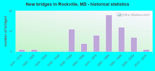
- New bridges - historical statistics
- 11910-1919
- 11920-1929
- 111950-1959
- 41960-1969
- 81970-1979
- 181980-1989
- 121990-1999
- 72000-2009
- 12010-2019

- Reconstructed bridges - Historical Statistics
- 11960-1969
- 11970-1979
- 21980-1989
- 41990-1999
- 22000-2009
- 12010-2019


- Bridge Condition - Deck
- 40.6%Good
- 50.0%Satisfactory
- 9.4%Fair

- Bridge Condition - Superstructure
- 7.9%Very good
- 42.1%Good
- 31.6%Satisfactory
- 13.2%Fair
- 5.3%Poor

- Bridge Condition - Substructure
- 7.9%Very good
- 28.9%Good
- 50.0%Satisfactory
- 13.2%Fair

- Bridge Condition - Channel
- 14.7%Very good
- 32.4%Good
- 41.2%Satisfactory
- 11.8%Fair

- Bridge Condition - Culverts
- 42.9%Good
- 57.1%Satisfactory
Find on map >> Show street view
Structure Number: 10000015000402, Location: 0.53 MILE WEST OF IS 270 (Lat: 39.091078, Lng: -77.179978), Route carried "on" structure: State highway 28, Year Built: 1988, Status: Open, Structure Length: 1.24m (4.07ft), Average Daily Traffic: 47,601 (year 2013), Truck Traffic: 8%, Average Future Daily Traffic: 57,558 (year 2026), Design Load: HS 20, Features Intersected: BR OF WATTS BRANCH
Minimum Vertical Clearance: 30+ m (98+ ft), Kilometerpoint: 33.178, Lanes on structure: 6, Base Highway Network: Yes, Owner: State Highway Agency, Approaching Roadway Width: 18.9m (62.0ft), Skew: 3 degrees, Material/Design: Concrete, Design/Construction: Culvert, Length of Maximum Span: 4.0m (13.1ft)
Condition: Channel: Satisfactory, Culverts: Good, Operating Rating: 32.7 metric tons, Method Used To Determine Operating Rating: Field evaluation and documented engineering judgment, Inventory Rating: 32.7 metric tons, Method Used To Determine Inventory Rating: Field evaluation and documented engineering judgment, Structural Evaluation: Better than present minimum criteria, Waterway Adequacy: Equal to present desirable criteria, Approach Roadway Alignment: Equal to present desirable criteria, Designated Inspection Frequency: Every 24 months, Inspection Date: August 2020
Find on map >> Show street view
Structure Number: 10000015000502, Location: 0.18 MILE WEST OF IS 270 (Lat: 39.087019, Lng: -77.176164), Route carried "on" structure: State highway 28, Year Built: 1955, Status: Open, Structure Length: 0.76m (2.49ft), Average Daily Traffic: 47,601 (year 2013), Truck Traffic: 8%, Average Future Daily Traffic: 57,558 (year 2026), Design Load: HS 20, Features Intersected: WATTS BRANCH
Minimum Vertical Clearance: 30+ m (98+ ft), Kilometerpoint: 33.741, Lanes on structure: 5, Base Highway Network: Yes, Owner: State Highway Agency, Approaching Roadway Width: 21.0m (68.9ft), Skew: 20 degrees, Material/Design: Concrete, Design/Construction: Culvert, Length of Maximum Span: 7.6m (24.9ft)
Condition: Channel: Satisfactory, Culverts: Satisfactory, Operating Rating: 32.7 metric tons, Method Used To Determine Operating Rating: Field evaluation and documented engineering judgment, Inventory Rating: 32.7 metric tons, Method Used To Determine Inventory Rating: Field evaluation and documented engineering judgment, Structural Evaluation: Equal to present minimum criteria, Waterway Adequacy: Equal to present minimum criteria, Approach Roadway Alignment: Equal to present desirable criteria, Designated Inspection Frequency: Every 24 months, Inspection Date: August 2020
Find on map >> Show street view
Structure Number: 10000015000601, Location: 0.19 MILE WEST OF MD 911 (Lat: 39.080567, Lng: -77.142039), Route carried "on" structure: State highway 28, Year Built: 1981, Status: Open, Structure Length: 9.54m (31.30ft), Average Daily Traffic: 27,020 (year 2009), Truck Traffic: 8%, Average Future Daily Traffic: 44,296 (year 2039), Design Load: HS 20, Features Intersected: CSXT, WMATA, RAMP
Minimum Vertical Clearance: 30+ m (98+ ft), Kilometerpoint: 36.943, Lanes on structure: 4, Lanes under structure: 1, Base Highway Network: Yes, Owner: State Highway Agency, Approaching Roadway Width: 22.6m (74.1ft), Skew: 23 degrees, Material/Design: Steel continuous, Design/Construction: Stringer/Multi-beam, Number Of Spans In Main Unit: 3, Length of Maximum Span: 31.7m (104.0ft), Curb or Sidewalk Widths: Left: 3.0m (9.8ft), Right: 1.5m (4.9ft), Curb-To-Curb Width: 22.6m (74.1ft), Out-to-Out Width: 27.4m (89.9ft)
Condition: Deck: Satisfactory, Superstructure: Satisfactory, Substructure: Satisfactory, Operating Rating: 80.3 metric tons, Method Used To Determine Operating Rating: Load Factor (LF), Inventory Rating: 48.1 metric tons, Method Used To Determine Inventory Rating: Load Factor (LF), Structural Evaluation: Equal to present minimum criteria, Deck Geometry: Superior to present desirable criteria, Underclear: High priority of corrective action, Approach Roadway Alignment: Equal to present desirable criteria, Designated Inspection Frequency: Every 24 months, Inspection Date: September 2021, Deck Structure Type: Concrete Cast-file-Place, Wearing Surface/Protective System: Wearing Surface: Monolithic Concrete, Deck Protection: Epoxy Coated Reinforcing
Find on map >> Show street view
Structure Number: 10000015004701, Location: 1.02 MI S OF MD 355 (Lat: 39.110158, Lng: -77.187739), Route carried "on" structure: County highway 212, Year Built: 1987, Year Reconstructed: 1995, Status: Open, Structure Length: 10.52m (34.51ft), Average Daily Traffic: 40,730 (year 2018), Truck Traffic: 5%, Average Future Daily Traffic: 40,766 (year 2038), Design Load: HS 20, Features Intersected: IS 270 & C-D ROADS, Facility Carried by Structure: SHADY GROVE ROAD
Minimum Vertical Clearance: 30+ m (98+ ft), Kilometerpoint: 2.301, Lanes on structure: 8, Lanes under structure: 14, Owner: State Highway Agency, Approaching Roadway Width: 35.7m (117.1ft), Skew: 33 degrees, Material/Design: Steel continuous, Design/Construction: Stringer/Multi-beam, Number Of Spans In Main Unit: 4, Length of Maximum Span: 26.5m (86.9ft), Curb or Sidewalk Widths: Left: 1.3m (4.3ft), Right: 1.3m (4.3ft), Curb-To-Curb Width: 29.6m (97.1ft), Out-to-Out Width: 33.6m (110.2ft)
Condition: Deck: Good, Superstructure: Good, Substructure: Satisfactory, Operating Rating: 59.9 metric tons, Method Used To Determine Operating Rating: Load Factor (LF), Inventory Rating: 35.8 metric tons, Method Used To Determine Inventory Rating: Load Factor (LF), Structural Evaluation: Equal to present minimum criteria, Deck Geometry: Meets minimum limits, Underclear: Meets minimum limits, Approach Roadway Alignment: Equal to present desirable criteria, Designated Inspection Frequency: Every 24 months, Inspection Date: January 2020, Deck Structure Type: Concrete Cast-file-Place, Wearing Surface/Protective System: Wearing Surface: Monolithic Concrete, Deck Protection: Epoxy Coated Reinforcing
Find on map >> Show street view
Structure Number: 10000015004801, Location: 0.96 MILE NORTH OF MD 189 (Lat: 39.085925, Lng: -77.173811), Route carried "on" structure: State highway 28, Year Built: 1955, Year Reconstructed: 1984, Status: Open, Structure Length: 9.05m (29.69ft), Average Daily Traffic: 26,090 (year 2009), Truck Traffic: 8%, Average Future Daily Traffic: 30,474 (year 2026), Design Load: HS 20, Features Intersected: IS 270 & C-D ROADS
Minimum Vertical Clearance: 30+ m (98+ ft), Kilometerpoint: 34.030, Lanes on structure: 6, Lanes under structure: 13, Base Highway Network: Yes, Owner: State Highway Agency, Approaching Roadway Width: 12.2m (40.0ft), Skew: 23 degrees, Material/Design: Steel, Design/Construction: Stringer/Multi-beam, Number Of Spans In Main Unit: 4, Length of Maximum Span: 24.7m (81.0ft), Curb or Sidewalk Widths: Left: 1.6m (5.2ft), Right: 1.6m (5.2ft), Curb-To-Curb Width: 28.7m (94.2ft), Out-to-Out Width: 32.4m (106.3ft)
Condition: Deck: Satisfactory, Superstructure: Satisfactory, Substructure: Fair, Inventory Rating: 55.3 metric tons, Method Used To Determine Inventory Rating: Load Factor (LF), Structural Evaluation: Somewhat better than minimum adequacy, Deck Geometry: Superior to present desirable criteria, Underclear: High priority of corrective action, Approach Roadway Alignment: Equal to present desirable criteria, Designated Inspection Frequency: Every 24 months, Inspection Date: April 2021, Deck Structure Type: Concrete Cast-file-Place, Wearing Surface/Protective System: Wearing Surface: Monolithic Concrete, Deck Protection: Epoxy Coated Reinforcing
Find on map >> Show street view
Structure Number: 10000015004901, Location: 0.96 MILE SOUTH OF MD 28 (Lat: 39.073633, Lng: -77.164703), Route carried "on" structure: State highway 189, Year Built: 1988, Status: Open, Structure Length: 7.62m (25.00ft), Average Daily Traffic: 9,304 (year 2009), Truck Traffic: 8%, Average Future Daily Traffic: 11,047 (year 2026), Design Load: HS 25 or greater, Features Intersected: IS 270 & C-D ROADS
Minimum Vertical Clearance: 30+ m (98+ ft), Kilometerpoint: 7.836, Lanes on structure: 6, Lanes under structure: 12, Owner: State Highway Agency, Approaching Roadway Width: 24.4m (80.1ft), Skew: 1 degrees, Material/Design: Steel continuous, Design/Construction: Stringer/Multi-beam, Number Of Spans In Main Unit: 4, Length of Maximum Span: 22.9m (75.1ft), Curb or Sidewalk Widths: Left: 1.5m (4.9ft), Right: 1.5m (4.9ft), Curb-To-Curb Width: 25.6m (84.0ft), Out-to-Out Width: 31.4m (103.0ft)
Condition: Deck: Good, Superstructure: Satisfactory, Substructure: Satisfactory, Operating Rating: 52.6 metric tons, Method Used To Determine Operating Rating: Load Factor (LF), Inventory Rating: 31.3 metric tons, Method Used To Determine Inventory Rating: Load Factor (LF), Structural Evaluation: Equal to present minimum criteria, Deck Geometry: Somewhat better than minimum adequacy, Underclear: Meets minimum limits, Approach Roadway Alignment: Equal to present desirable criteria, Designated Inspection Frequency: Every 24 months, Inspection Date: June 2021, Deck Structure Type: Concrete Cast-file-Place, Wearing Surface/Protective System: Wearing Surface: Integral Concrete, Deck Protection: Epoxy Coated Reinforcing
Find on map >> Show street view
Structure Number: 10000015006402, Location: 0.21 MILE NORTH OF MD 28 (Lat: 39.088850, Lng: -77.173947), Route carried "on" structure: Interstate 270, Year Built: 1955, Year Reconstructed: 1988, Status: Open, Structure Length: 0.85m (2.79ft), Average Daily Traffic: 239,460 (year 2009), Truck Traffic: 8%, Average Future Daily Traffic: 330,700 (year 2029), Design Load: HS 20, Features Intersected: WATTS BRANCH
Minimum Vertical Clearance: 30+ m (98+ ft), Kilometerpoint: 10.732, Lanes on structure: 13, Base Highway Network: Yes, Owner: State Highway Agency, Approaching Roadway Width: 62.5m (205.1ft), Skew: 2 degrees, Material/Design: Concrete, Design/Construction: Culvert, Length of Maximum Span: 7.6m (24.9ft)
Condition: Channel: Very good, Culverts: Satisfactory, Inventory Rating: 57.6 metric tons, Method Used To Determine Inventory Rating: Load Factor (LF), Structural Evaluation: Equal to present minimum criteria, Waterway Adequacy: Equal to present desirable criteria, Approach Roadway Alignment: Equal to present desirable criteria, Designated Inspection Frequency: Every 24 months, Inspection Date: September 2020
Find on map >> Show street view
Structure Number: 10000015014703, Location: 0.55 MILE EAST OF MD 911 (Lat: 39.087103, Lng: -77.134797), Route carried "on" structure: State highway 28, Year Built: 1970, Status: Open, Structure Length: 1.25m (4.10ft), Average Daily Traffic: 34,390 (year 2009), Truck Traffic: 8%, Average Future Daily Traffic: 42,915 (year 2026), Design Load: HS 20, Features Intersected: BRANCH OF ROCK CREEK
Minimum Vertical Clearance: 30+ m (98+ ft), Kilometerpoint: 38.133, Lanes on structure: 4, Base Highway Network: Yes, Owner: State Highway Agency, Approaching Roadway Width: 20.7m (67.9ft), Material/Design: Steel, Design/Construction: Culvert, Length of Maximum Span: 3.4m (11.2ft)
Condition: Channel: Satisfactory, Culverts: Satisfactory, Structural Evaluation: Equal to present minimum criteria, Waterway Adequacy: Superior to present desirable criteria, Approach Roadway Alignment: Equal to present desirable criteria, Designated Inspection Frequency: Every 24 months, Inspection Date: August 2020
Find on map >> Show street view
Structure Number: 200000M-004901, Location: 0.75 MI N OF JCT SR 28 (Lat: 39.101611, Lng: -77.124933), Route carried "on" structure: County highway 139, Year Built: 1994, Status: Open, Structure Length: 4.57m (14.99ft), Average Daily Traffic: 4,535 (year 2021), Truck Traffic: 3%, Average Future Daily Traffic: 5,351 (year 2041), Design Load: HS 20, Features Intersected: ROCK CREEK, Facility Carried by Structure: AVERY ROAD
Minimum Vertical Clearance: 30+ m (98+ ft), Kilometerpoint: 1.030, Lanes on structure: 2, Owner: County Highway Agency, Approaching Roadway Width: 8.5m (27.9ft), Skew: 1 degrees, Material/Design: Steel continuous, Design/Construction: Stringer/Multi-beam, Number Of Spans In Main Unit: 2, Length of Maximum Span: 22.3m (73.2ft), Curb-To-Curb Width: 8.5m (27.9ft), Out-to-Out Width: 9.5m (31.2ft)
Condition: Deck: Good, Superstructure: Good, Substructure: Good, Channel: Good, Inventory Rating: 74.8 metric tons, Method Used To Determine Inventory Rating: Load Factor (LF), Structural Evaluation: Better than present minimum criteria, Deck Geometry: Meets minimum limits, Waterway Adequacy: Better than present minimum criteria, Approach Roadway Alignment: Equal to present minimum criteria, Length Of Structure Improvement: 4.57m (14.99ft), Designated Inspection Frequency: Every 24 months, Inspection Date: August 2021, Bridge Improvement Cost: $10,000, Total Project Cost: $10,000, Deck Structure Type: Concrete Cast-file-Place, Wearing Surface/Protective System: Wearing Surface: Integral Concrete
Find on map >> Show street view
Structure Number: 200000M-005001, Location: 0.25 MI W OF AVERY RD (Lat: 39.106042, Lng: -77.125236), Route carried "on" structure: County highway 140, Year Built: 1920, Year Reconstructed: 2002, Status: Open, Structure Length: 0.99m (3.25ft), Average Daily Traffic: 16,371 (year 2019), Truck Traffic: 5%, Average Future Daily Traffic: 19,310 (year 2039), Design Load: HS 20, Features Intersected: ROCK CREEK, Facility Carried by Structure: SOUTHLAWN LANE
Minimum Vertical Clearance: 30+ m (98+ ft), Kilometerpoint: 0.386, Lanes on structure: 2, Owner: County Highway Agency, Approaching Roadway Width: 7.3m (24.0ft), Material/Design: Steel, Design/Construction: Stringer/Multi-beam, Number Of Spans In Main Unit: 1, Length of Maximum Span: 9.1m (29.9ft), Curb-To-Curb Width: 9.0m (29.5ft), Out-to-Out Width: 9.2m (30.2ft)
Condition: Deck: Fair, Superstructure: Poor, Substructure: Satisfactory, Channel: Good, Operating Rating: 45.8 metric tons, Method Used To Determine Operating Rating: Load Factor (LF), Inventory Rating: 27.7 metric tons, Method Used To Determine Inventory Rating: Load Factor (LF), Structural Evaluation: Meets minimum limits, Deck Geometry: High priority of replacement, Waterway Adequacy: Better than present minimum criteria, Approach Roadway Alignment: Equal to present desirable criteria, Length Of Structure Improvement: 0.98m (3.22ft), Designated Inspection Frequency: Every 12 months, Inspection Date: August 2021, Bridge Improvement Cost: $20,000, Roadway Improvement Cost: $2,000, Total Project Cost: $22,000, Deck Structure Type: Corrugated Steel, Wearing Surface/Protective System: Wearing Surface: Bituminous
Find on map >> Show street view
Structure Number: 200000M-005702, Location: 0.7 MILES EAST OF MD 355 (Lat: 39.121922, Lng: -77.157492), Route carried "on" structure: County highway 1936, Year Built: 1981, Year Reconstructed: 2007, Status: Open, Structure Length: 0.62m (2.03ft), Average Daily Traffic: 25,118 (year 2019), Truck Traffic: 5%, Average Future Daily Traffic: 28,878 (year 2039), Design Load: HS 20, Features Intersected: CRABBS CREEK, Facility Carried by Structure: REDLAND ROAD
Minimum Vertical Clearance: 30+ m (98+ ft), Kilometerpoint: 0.000, Lanes on structure: 4, Owner: County Highway Agency, Approaching Roadway Width: 13.7m (44.9ft), Material/Design: Concrete, Design/Construction: Culvert, Length of Maximum Span: 3.0m (9.8ft), Curb or Sidewalk Widths: Left: 2.6m (8.5ft), Right: 1.4m (4.6ft)
Condition: Channel: Good, Culverts: Good, Structural Evaluation: Better than present minimum criteria, Waterway Adequacy: Equal to present desirable criteria, Approach Roadway Alignment: Equal to present desirable criteria, Designated Inspection Frequency: Every 24 months, Inspection Date: August 2020
Find on map >> Show street view
Structure Number: 200000M-0080013, Location: 1.5 MILES EAST OF MD 355 (Lat: 39.053525, Lng: -77.091272), Route carried "on" structure: County highway 1659, Year Built: 1953, Year Reconstructed: 1966, Status: Open, Structure Length: 2.50m (8.20ft), Average Daily Traffic: 26,347 (year 2021), Truck Traffic: 5%, Average Future Daily Traffic: 32,660 (year 2041), Design Load: HS 20, Features Intersected: ROCK CREEK, Facility Carried by Structure: RANDOLPH ROAD (EB)
Minimum Vertical Clearance: 30+ m (98+ ft), Kilometerpoint: 1.963, Lanes on structure: 3, Base Highway Network: Yes (Inventory Route: 15000CO1, Subroute: 9), Owner: County Highway Agency, Approaching Roadway Width: 9.1m (29.9ft), Skew: 30 degrees, Material/Design: Steel, Design/Construction: Stringer/Multi-beam, Number Of Spans In Main Unit: 2, Length of Maximum Span: 12.2m (40.0ft), Curb or Sidewalk Widths: Left: 0.0m, Right: 3.0m (9.8ft), Curb-To-Curb Width: 9.1m (29.9ft), Out-to-Out Width: 13.9m (45.6ft)
Condition: Deck: Satisfactory, Superstructure: Fair, Substructure: Satisfactory, Channel: Satisfactory, Operating Rating: 74.8 metric tons, Method Used To Determine Operating Rating: Load Factor (LF), Inventory Rating: 44.9 metric tons, Method Used To Determine Inventory Rating: Load Factor (LF), Structural Evaluation: Somewhat better than minimum adequacy, Deck Geometry: High priority of replacement, Waterway Adequacy: Equal to present minimum criteria, Approach Roadway Alignment: Equal to present desirable criteria, Length Of Structure Improvement: 2.50m (8.20ft), Designated Inspection Frequency: Every 24 months, Inspection Date: July 2021, Bridge Improvement Cost: $32,000, Roadway Improvement Cost: $3,000, Total Project Cost: $35,000, Deck Structure Type: Concrete Cast-file-Place, Wearing Surface/Protective System: Wearing Surface: Bituminous
Find on map >> Show street view
Structure Number: 200000M-0080014, Location: 0.6 MILES WEST OF MD 586 (Lat: 39.053633, Lng: -77.091242), Route carried "on" structure: County highway 1659, Year Built: 1951, Year Reconstructed: 1993, Status: Open, Structure Length: 2.50m (8.20ft), Average Daily Traffic: 26,347 (year 2021), Truck Traffic: 5%, Average Future Daily Traffic: 32,660 (year 2041), Design Load: HS 20, Features Intersected: ROCK CREEK, Facility Carried by Structure: RANDOLPH ROAD (WB)
Minimum Vertical Clearance: 30+ m (98+ ft), Kilometerpoint: 1.963, Lanes on structure: 2, Base Highway Network: Yes (Inventory Route: 15000CO1, Subroute: 9), Owner: County Highway Agency, Approaching Roadway Width: 9.1m (29.9ft), Skew: 30 degrees, Material/Design: Steel, Design/Construction: Stringer/Multi-beam, Number Of Spans In Main Unit: 2, Length of Maximum Span: 12.2m (40.0ft), Curb or Sidewalk Widths: Left: 0.0m, Right: 1.4m (4.6ft), Curb-To-Curb Width: 9.1m (29.9ft), Out-to-Out Width: 11.3m (37.1ft)
Condition: Deck: Good, Superstructure: Satisfactory, Substructure: Satisfactory, Channel: Satisfactory, Inventory Rating: 66.2 metric tons, Method Used To Determine Inventory Rating: Load Factor (LF), Structural Evaluation: Equal to present minimum criteria, Deck Geometry: Meets minimum limits, Waterway Adequacy: Equal to present minimum criteria, Approach Roadway Alignment: Equal to present desirable criteria, Length Of Structure Improvement: 2.50m (8.20ft), Designated Inspection Frequency: Every 24 months, Inspection Date: July 2021, Bridge Improvement Cost: $20,000, Roadway Improvement Cost: $2,000, Total Project Cost: $22,000, Deck Structure Type: Concrete Cast-file-Place, Wearing Surface/Protective System: Wearing Surface: Integral Concrete, Deck Protection: Galvanized Reinforcing
Find on map >> Show street view
Structure Number: 200000M-0131013, Location: 0.1 MILE EAST OF MD 355 (Lat: 39.106383, Lng: -77.156631), Route carried "on" structure: County highway 3815, Year Built: 1989, Status: Open, Structure Length: 4.85m (15.91ft), Average Daily Traffic: 23,262 (year 2019), Truck Traffic: 5%, Average Future Daily Traffic: 26,360 (year 2041), Design Load: HS 20, Features Intersected: CSXT RR & WMATA METRO, Facility Carried by Structure: EAST GUDE DRIVE (E
Minimum Vertical Clearance: 30+ m (98+ ft), Kilometerpoint: 12.518, Lanes on structure: 3, Owner: County Highway Agency, Approaching Roadway Width: 11.6m (38.1ft), Skew: 1 degrees, Material/Design: Steel continuous, Design/Construction: Stringer/Multi-beam, Number Of Spans In Main Unit: 2, Length of Maximum Span: 23.5m (77.1ft), Curb or Sidewalk Widths: Left: 0.5m (1.6ft), Right: 2.9m (9.5ft), Curb-To-Curb Width: 11.6m (38.1ft), Out-to-Out Width: 15.6m (51.2ft)
Condition: Deck: Satisfactory, Superstructure: Good, Substructure: Satisfactory, Inventory Rating: 59.4 metric tons, Method Used To Determine Inventory Rating: Load Factor (LF), Structural Evaluation: Equal to present minimum criteria, Deck Geometry: High priority of replacement, Underclear: Meets minimum limits, Approach Roadway Alignment: Equal to present desirable criteria, Length Of Structure Improvement: 4.85m (15.91ft), Designated Inspection Frequency: Every 24 months, Inspection Date: January 2021, Bridge Improvement Cost: $26,000, Roadway Improvement Cost: $3,000, Total Project Cost: $29,000, Deck Structure Type: Concrete Cast-file-Place, Wearing Surface/Protective System: Wearing Surface: Monolithic Concrete, Deck Protection: Epoxy Coated Reinforcing
Find on map >> Show street view
Structure Number: 200000M-0131014, Location: 0.1 MI EAST OF MD 355 (Lat: 39.106683, Lng: -77.156158), Route carried "on" structure: County highway 3815, Year Built: 1968, Year Reconstructed: 2012, Status: Open, Structure Length: 5.76m (18.90ft), Average Daily Traffic: 23,259 (year 2019), Truck Traffic: 5%, Average Future Daily Traffic: 26,358 (year 2041), Design Load: HS 20, Features Intersected: CSXT RR & WMATA METRO, Facility Carried by Structure: EAST GUDE DRIVE (W
Minimum Vertical Clearance: 30+ m (98+ ft), Kilometerpoint: 0.177, Lanes on structure: 3, Owner: County Highway Agency, Approaching Roadway Width: 11.6m (38.1ft), Skew: 1 degrees, Material/Design: Steel continuous, Design/Construction: Stringer/Multi-beam, Number Of Spans In Main Unit: 4, Length of Maximum Span: 17.7m (58.1ft), Curb or Sidewalk Widths: Left: 1.6m (5.2ft), Right: 0.2m (0.7ft), Curb-To-Curb Width: 11.9m (39.0ft), Out-to-Out Width: 14.2m (46.6ft)
Condition: Deck: Satisfactory, Superstructure: Satisfactory, Substructure: Satisfactory, Operating Rating: 65.3 metric tons, Method Used To Determine Operating Rating: Load Factor (LF), Inventory Rating: 39.0 metric tons, Method Used To Determine Inventory Rating: Load Factor (LF), Structural Evaluation: Equal to present minimum criteria, Deck Geometry: High priority of corrective action, Underclear: Meets minimum limits, Approach Roadway Alignment: Equal to present minimum criteria, Length Of Structure Improvement: 5.82m (19.09ft), Designated Inspection Frequency: Every 24 months, Inspection Date: January 2021, Bridge Improvement Cost: $831,000, Roadway Improvement Cost: $83,000, Total Project Cost: $1,247,000, Deck Structure Type: Concrete Cast-file-Place, Wearing Surface/Protective System: Wearing Surface: Monolithic Concrete, Membrane: Preformed Fabric, Deck Protection: Epoxy Coated Reinforcing
Find on map >> Show street view
Structure Number: 200000M-013301, Location: 1 MI E OF MD RTE 355 (Lat: 39.114019, Lng: -44.160119), Route carried "on" structure: County highway 5052, Year Built: 1981, Status: Open, Structure Length: 6.28m (20.60ft), Average Daily Traffic: 1,027 (year 2019), Truck Traffic: 5%, Average Future Daily Traffic: 1,197 (year 2041), Design Load: HS 20, Features Intersected: CSXT RR & WMATA METRO, Facility Carried by Structure: INDIANOLA DRIVE
Minimum Vertical Clearance: 30+ m (98+ ft), Kilometerpoint: 0.290, Lanes on structure: 2, Owner: County Highway Agency, Approaching Roadway Width: 7.9m (25.9ft), Skew: 2 degrees, Material/Design: Steel continuous, Design/Construction: Stringer/Multi-beam, Number Of Spans In Main Unit: 2, Length of Maximum Span: 32.0m (105.0ft), Curb or Sidewalk Widths: Left: 2.1m (6.9ft), Right: 2.1m (6.9ft), Curb-To-Curb Width: 7.9m (25.9ft), Out-to-Out Width: 12.8m (42.0ft)
Condition: Deck: Satisfactory, Superstructure: Satisfactory, Substructure: Satisfactory, Operating Rating: 87.1 metric tons, Method Used To Determine Operating Rating: Load Factor (LF), Inventory Rating: 52.2 metric tons, Method Used To Determine Inventory Rating: Load Factor (LF), Structural Evaluation: Equal to present minimum criteria, Deck Geometry: Meets minimum limits, Underclear: High priority of corrective action, Approach Roadway Alignment: Equal to present minimum criteria, Length Of Structure Improvement: 6.28m (20.60ft), Designated Inspection Frequency: Every 24 months, Inspection Date: December 2020, Bridge Improvement Cost: $30,000, Roadway Improvement Cost: $3,000, Total Project Cost: $33,000, Deck Structure Type: Concrete Cast-file-Place, Wearing Surface/Protective System: Wearing Surface: Monolithic Concrete, Deck Protection: Epoxy Coated Reinforcing
Find on map >> Show street view
Structure Number: 200000M-014601, Location: 1.2 MILES WEST OF MD 187 (Lat: 39.043942, Lng: -77.137939), Route carried "on" structure: County highway 3016, Year Built: 1972, Status: Open, Structure Length: 0.70m (2.30ft), Average Daily Traffic: 6,155 (year 2019), Truck Traffic: 5%, Average Future Daily Traffic: 7,622 (year 2039), Design Load: HS 20, Features Intersected: OLD FARM CREEK, Facility Carried by Structure: TILDEN LANE
Minimum Vertical Clearance: 30+ m (98+ ft), Kilometerpoint: 0.821, Lanes on structure: 2, Owner: County Highway Agency, Approaching Roadway Width: 11.3m (37.1ft), Material/Design: Steel, Design/Construction: Arch - Deck, Number Of Spans In Main Unit: 1, Length of Maximum Span: 7.0m (23.0ft), Curb or Sidewalk Widths: Left: 1.2m (3.9ft), Right: 1.2m (3.9ft), Curb-To-Curb Width: 11.0m (36.1ft), Out-to-Out Width: 11.3m (37.1ft)
Condition: Superstructure: Fair, Substructure: Satisfactory, Channel: Satisfactory, Structural Evaluation: Somewhat better than minimum adequacy, Deck Geometry: Meets minimum limits, Waterway Adequacy: Better than present minimum criteria, Approach Roadway Alignment: Equal to present minimum criteria, Length Of Structure Improvement: 0.70m (2.30ft), Designated Inspection Frequency: Every 24 months, Inspection Date: Febuary 2021, Bridge Improvement Cost: $24,000, Roadway Improvement Cost: $2,000, Total Project Cost: $26,000
Find on map >> Show street view
Structure Number: 200000M-015401, Location: 0.24 MILES EAST OF MD 355 (Lat: 39.059281, Lng: -77.117483), Route carried "on" structure: County highway 3241, Year Built: 1964, Year Reconstructed: 1998, Status: Open, Structure Length: 5.03m (16.50ft), Average Daily Traffic: 39,672 (year 2019), Truck Traffic: 12%, Average Future Daily Traffic: 50,268 (year 2041), Design Load: HS 25 or greater, Features Intersected: CSXT RR & WMATA METRO, Facility Carried by Structure: TWINBROOK PARKWAY
Minimum Vertical Clearance: 30+ m (98+ ft), Kilometerpoint: 3.138, Lanes on structure: 4, Owner: County Highway Agency, Approaching Roadway Width: 14.6m (47.9ft), Material/Design: Steel continuous, Design/Construction: Stringer/Multi-beam, Number Of Spans In Main Unit: 3, Length of Maximum Span: 24.7m (81.0ft), Curb or Sidewalk Widths: Left: 1.5m (4.9ft), Right: 1.5m (4.9ft), Curb-To-Curb Width: 14.6m (47.9ft), Out-to-Out Width: 18.3m (60.0ft)
Condition: Deck: Good, Superstructure: Good, Substructure: Satisfactory, Inventory Rating: 54.9 metric tons, Method Used To Determine Inventory Rating: Load Factor (LF), Structural Evaluation: Equal to present minimum criteria, Deck Geometry: High priority of replacement, Underclear: Equal to present minimum criteria, Approach Roadway Alignment: Equal to present minimum criteria, Designated Inspection Frequency: Every 24 months, Inspection Date: August 2020, Deck Structure Type: Concrete Cast-file-Place, Wearing Surface/Protective System: Wearing Surface: Monolithic Concrete, Deck Protection: Epoxy Coated Reinforcing
Find on map >> Show street view
Structure Number: 200000M-0191013, Location: 0.5 MI EAST OF MD 355 (Lat: 39.127761, Lng: -77.171053), Route carried "on" structure: County highway 212, Year Built: 1976, Status: Open, Structure Length: 5.55m (18.21ft), Average Daily Traffic: 18,225 (year 2011), Truck Traffic: 5%, Average Future Daily Traffic: 32,000 (year 2031), Design Load: HS 20, Features Intersected: CSXT RAILROAD, Facility Carried by Structure: SHADY GROVE RD EB
Minimum Vertical Clearance: 30+ m (98+ ft), Kilometerpoint: 7.224, Lanes on structure: 3, Base Highway Network: Yes (Inventory Route: 15000CO0, Subroute: 12), Owner: County Highway Agency, Approaching Roadway Width: 12.2m (40.0ft), Skew: 1 degrees, Material/Design: Steel, Design/Construction: Stringer/Multi-beam, Number Of Spans In Main Unit: 3, Length of Maximum Span: 27.1m (88.9ft), Curb or Sidewalk Widths: Left: 1.5m (4.9ft), Right: 0.0m, Curb-To-Curb Width: 12.2m (40.0ft), Out-to-Out Width: 14.5m (47.6ft)
Condition: Deck: Satisfactory, Superstructure: Good, Substructure: Fair, Inventory Rating: 76.6 metric tons, Method Used To Determine Inventory Rating: Load Factor (LF), Structural Evaluation: Somewhat better than minimum adequacy, Deck Geometry: Meets minimum limits, Underclear: Equal to present desirable criteria, Approach Roadway Alignment: Equal to present desirable criteria, Designated Inspection Frequency: Every 24 months, Inspection Date: November 2020, Deck Structure Type: Concrete Cast-file-Place, Wearing Surface/Protective System: Wearing Surface: Monolithic Concrete, Deck Protection: Epoxy Coated Reinforcing
Find on map >> Show street view
Structure Number: 200000M-0191014, Location: 0.5 MI EAST OF MD 355 (Lat: 39.127906, Lng: -77.171167), Route carried "on" structure: County highway 212, Year Built: 1976, Status: Open, Structure Length: 5.55m (18.21ft), Average Daily Traffic: 34,382 (year 2017), Truck Traffic: 5%, Average Future Daily Traffic: 32,000 (year 2037), Design Load: HS 20, Features Intersected: CSXT RAILROAD, Facility Carried by Structure: SHADY GROVE RD WB
Minimum Vertical Clearance: 30+ m (98+ ft), Kilometerpoint: 7.224, Lanes on structure: 3, Base Highway Network: Yes (Inventory Route: 15000CO0, Subroute: 12), Owner: County Highway Agency, Approaching Roadway Width: 12.2m (40.0ft), Skew: 1 degrees, Material/Design: Steel, Design/Construction: Stringer/Multi-beam, Number Of Spans In Main Unit: 3, Length of Maximum Span: 27.1m (88.9ft), Curb or Sidewalk Widths: Left: 1.5m (4.9ft), Right: 0.0m, Curb-To-Curb Width: 12.2m (40.0ft), Out-to-Out Width: 14.5m (47.6ft)
Condition: Deck: Fair, Superstructure: Good, Substructure: Fair, Inventory Rating: 76.6 metric tons, Method Used To Determine Inventory Rating: Load Factor (LF), Structural Evaluation: Somewhat better than minimum adequacy, Deck Geometry: Meets minimum limits, Underclear: Equal to present desirable criteria, Approach Roadway Alignment: Equal to present desirable criteria, Designated Inspection Frequency: Every 24 months, Inspection Date: December 2020, Deck Structure Type: Concrete Cast-file-Place, Wearing Surface/Protective System: Wearing Surface: Monolithic Concrete, Deck Protection: Epoxy Coated Reinforcing
Find on map >> Show street view
Structure Number: 200000M-020101, Location: 0.5 MI S OF JCT SR 28 (Lat: 39.090003, Lng: -77.115233), Route carried "on" structure: County highway 4560, Year Built: 1911, Status: Open, Structure Length: 1.80m (5.91ft), Average Daily Traffic: 10,493 (year 2019), Truck Traffic: 3%, Average Future Daily Traffic: 12,172 (year 2039), Features Intersected: ROCK CREEK, Facility Carried by Structure: BALTIMORE ROAD
Minimum Vertical Clearance: 30+ m (98+ ft), Kilometerpoint: 0.338, Lanes on structure: 2, Owner: County Highway Agency, Approaching Roadway Width: 6.7m (22.0ft), Material/Design: Concrete, Design/Construction: Arch - Deck, Number Of Spans In Main Unit: 1, Length of Maximum Span: 18.0m (59.1ft), Curb-To-Curb Width: 6.6m (21.7ft), Out-to-Out Width: 7.3m (24.0ft)
Condition: Superstructure: Fair, Substructure: Satisfactory, Channel: Satisfactory, Operating Rating: 32.7 metric tons, Method Used To Determine Operating Rating: Field evaluation and documented engineering judgment, Inventory Rating: 32.7 metric tons, Method Used To Determine Inventory Rating: Field evaluation and documented engineering judgment, Structural Evaluation: Somewhat better than minimum adequacy, Deck Geometry: High priority of replacement, Waterway Adequacy: Better than present minimum criteria, Approach Roadway Alignment: Equal to present desirable criteria, Length Of Structure Improvement: 1.80m (5.91ft), Designated Inspection Frequency: Every 24 months, Inspection Date: July 2021, Bridge Improvement Cost: $250,000, Roadway Improvement Cost: $25,000, Total Project Cost: $275,000, Deck Structure Type: Concrete Cast-file-Place, Wearing Surface/Protective System: Wearing Surface: Bituminous
Find on map >> Show street view
Structure Number: 200000M-020301, Location: 0.2 MI E OF MD RTE 355 (Lat: 39.118019, Lng: -77.163481), Route carried "on" structure: County highway 1936, Year Built: 1980, Status: Open, Structure Length: 7.10m (23.29ft), Average Daily Traffic: 20,246 (year 2021), Truck Traffic: 5%, Average Future Daily Traffic: 23,285 (year 2041), Design Load: HS 20, Features Intersected: CSXT RR & WMATA METRO, Facility Carried by Structure: REDLAND ROAD
Minimum Vertical Clearance: 30+ m (98+ ft), Kilometerpoint: 3.797, Lanes on structure: 4, Owner: County Highway Agency, Approaching Roadway Width: 15.2m (49.9ft), Material/Design: Steel continuous, Design/Construction: Stringer/Multi-beam, Number Of Spans In Main Unit: 2, Length of Maximum Span: 34.7m (113.8ft), Curb or Sidewalk Widths: Left: 2.1m (6.9ft), Right: 2.1m (6.9ft), Curb-To-Curb Width: 15.2m (49.9ft), Out-to-Out Width: 20.1m (65.9ft)
Condition: Deck: Satisfactory, Superstructure: Satisfactory, Substructure: Fair, Operating Rating: 68.9 metric tons, Method Used To Determine Operating Rating: Load Factor (LF), Inventory Rating: 41.3 metric tons, Method Used To Determine Inventory Rating: Load Factor (LF), Structural Evaluation: Somewhat better than minimum adequacy, Deck Geometry: High priority of corrective action, Underclear: Meets minimum limits, Approach Roadway Alignment: Equal to present desirable criteria, Designated Inspection Frequency: Every 24 months, Inspection Date: July 2021, Deck Structure Type: Concrete Cast-file-Place, Wearing Surface/Protective System: Wearing Surface: Monolithic Concrete, Deck Protection: Epoxy Coated Reinforcing
Find on map >> Show street view
Structure Number: 200000M-020501, Location: .7 MI S OF SHADY GROVE RD (Lat: 39.123719, Lng: -77.162286), Route carried "on" structure: County highway 4991, Year Built: 1983, Status: Open, Structure Length: 6.16m (20.21ft), Average Daily Traffic: 42,915 (year 2021), Truck Traffic: 5%, Average Future Daily Traffic: 49,341 (year 2041), Design Load: HS 20, Features Intersected: METRO ACCESS ROAD, Facility Carried by Structure: CRABBS BRANCH WAY
Minimum Vertical Clearance: 30+ m (98+ ft), Kilometerpoint: 1.046, Lanes on structure: 4, Lanes under structure: 6, Owner: County Highway Agency, Approaching Roadway Width: 15.2m (49.9ft), Material/Design: Steel continuous, Design/Construction: Stringer/Multi-beam, Number Of Spans In Main Unit: 2, Length of Maximum Span: 34.4m (112.9ft), Curb or Sidewalk Widths: Left: 2.7m (8.9ft), Right: 2.7m (8.9ft), Curb-To-Curb Width: 15.2m (49.9ft), Out-to-Out Width: 21.3m (69.9ft)
Condition: Deck: Satisfactory, Superstructure: Good, Substructure: Satisfactory, Inventory Rating: 56.2 metric tons, Method Used To Determine Inventory Rating: Load Factor (LF), Structural Evaluation: Equal to present minimum criteria, Deck Geometry: High priority of corrective action, Underclear: Equal to present minimum criteria, Approach Roadway Alignment: Equal to present desirable criteria, Designated Inspection Frequency: Every 24 months, Inspection Date: July 2021, Deck Structure Type: Concrete Cast-file-Place, Wearing Surface/Protective System: Wearing Surface: Monolithic Concrete, Membrane: Other, Deck Protection: Epoxy Coated Reinforcing
Find on map >> Show street view
Structure Number: 200000M-020702, Location: 0.1 MI W OF REDLAND RD (Lat: 39.121872, Lng: -77.159936), Route carried "on" structure: County highway 4991, Year Built: 1982, Status: Open, Structure Length: 0.98m (3.22ft), Average Daily Traffic: 43,413 (year 2021), Truck Traffic: 5%, Average Future Daily Traffic: 49,621 (year 2041), Design Load: HS 20, Features Intersected: CRABBS CREEK, Facility Carried by Structure: CRABBS BRANCH WAY
Minimum Vertical Clearance: 30+ m (98+ ft), Kilometerpoint: 1.319, Lanes on structure: 4, Owner: County Highway Agency, Approaching Roadway Width: 15.2m (49.9ft), Material/Design: Concrete, Design/Construction: Culvert, Length of Maximum Span: 3.0m (9.8ft), Curb or Sidewalk Widths: Left: 0.0m, Right: 2.1m (6.9ft)
Condition: Channel: Satisfactory, Culverts: Satisfactory, Inventory Rating: 57.1 metric tons, Method Used To Determine Inventory Rating: Load Factor (LF), Structural Evaluation: Equal to present minimum criteria, Waterway Adequacy: Equal to present minimum criteria, Approach Roadway Alignment: Equal to present desirable criteria, Designated Inspection Frequency: Every 24 months, Inspection Date: October 2021
Find on map >> Show street view
Structure Number: 200000M-021101, Location: 0.1 MI W OF I-270 (Lat: 39.056981, Lng: -77.158192), Route carried "on" structure: County highway 144, Year Built: 1990, Status: Open, Structure Length: 1.80m (5.91ft), Average Daily Traffic: 33,227 (year 2019), Truck Traffic: 5%, Average Future Daily Traffic: 37,214 (year 2039), Design Load: HS 20, Features Intersected: RAMP TO I-270, Facility Carried by Structure: MONTROSE ROAD
Minimum Vertical Clearance: 30+ m (98+ ft), Kilometerpoint: 0.000, Lanes on structure: 8, Lanes under structure: 2, Owner: County Highway Agency, Approaching Roadway Width: 35.1m (115.2ft), Skew: 30 degrees, Material/Design: Steel, Design/Construction: Stringer/Multi-beam, Number Of Spans In Main Unit: 1, Length of Maximum Span: 16.8m (55.1ft), Curb or Sidewalk Widths: Left: 1.9m (6.2ft), Right: 1.9m (6.2ft), Curb-To-Curb Width: 31.4m (103.0ft), Out-to-Out Width: 40.1m (131.6ft)
Condition: Deck: Good, Superstructure: Good, Substructure: Good, Inventory Rating: 68.5 metric tons, Method Used To Determine Inventory Rating: Load Factor (LF), Structural Evaluation: Better than present minimum criteria, Deck Geometry: Somewhat better than minimum adequacy, Underclear: High priority of corrective action, Approach Roadway Alignment: Equal to present desirable criteria, Designated Inspection Frequency: Every 24 months, Inspection Date: August 2021, Deck Structure Type: Concrete Cast-file-Place, Wearing Surface/Protective System: Wearing Surface: Integral Concrete
Find on map >> Show street view
Structure Number: 200000M-031501, Location: 0.5 MI. W. OF JEFFERSON (Lat: 39.053442, Lng: -77.134847), Route carried "on" structure: County highway 144, Year Built: 2008, Status: Open, Structure Length: 1.68m (5.51ft), Average Daily Traffic: 61,750 (year 2021), Truck Traffic: 5%, Average Future Daily Traffic: 76,569 (year 2041), Design Load: HS 25 or greater, Features Intersected: OLD FARM CREEK, Facility Carried by Structure: MONTROSE ROAD
Minimum Vertical Clearance: 30+ m (98+ ft), Kilometerpoint: 0.000, Lanes on structure: 4, Owner: County Highway Agency, Approaching Roadway Width: 20.1m (65.9ft), Material/Design: Steel, Design/Construction: Stringer/Multi-beam, Number Of Spans In Main Unit: 1, Length of Maximum Span: 15.2m (49.9ft), Curb or Sidewalk Widths: Left: 1.6m (5.2ft), Right: 1.6m (5.2ft), Curb-To-Curb Width: 20.0m (65.6ft), Out-to-Out Width: 24.0m (78.7ft)
Condition: Deck: Good, Superstructure: Very good, Substructure: Good, Channel: Good, Inventory Rating: 85.7 metric tons, Method Used To Determine Inventory Rating: Load Factor (LF), Structural Evaluation: Better than present minimum criteria, Deck Geometry: Better than present minimum criteria, Waterway Adequacy: Equal to present desirable criteria, Approach Roadway Alignment: Equal to present desirable criteria, Designated Inspection Frequency: Every 24 months, Inspection Date: September 2021, Deck Structure Type: Concrete Cast-file-Place, Wearing Surface/Protective System: Wearing Surface: Integral Concrete
Find on map >> Show street view
Structure Number: 200000M-033101, Location: 1.0 MILE EAST OF I-270 (Lat: 39.051531, Lng: -77.134706), Route carried "on" structure: County highway 6197, Year Built: 2007, Status: Open, Structure Length: 2.71m (8.89ft), Average Daily Traffic: 32,493 (year 2021), Truck Traffic: 5%, Average Future Daily Traffic: 40,291 (year 2041), Design Load: HS 25 or greater, Features Intersected: OLD FARM CREEK, Facility Carried by Structure: MONTROSE PARKWAY
Minimum Vertical Clearance: 30+ m (98+ ft), Kilometerpoint: 0.000, Lanes on structure: 4, Owner: County Highway Agency, Approaching Roadway Width: 19.2m (63.0ft), Skew: 20 degrees, Material/Design: Steel, Design/Construction: Stringer/Multi-beam, Number Of Spans In Main Unit: 1, Length of Maximum Span: 25.6m (84.0ft), Curb or Sidewalk Widths: Left: 0.5m (1.6ft), Right: 2.0m (6.6ft), Curb-To-Curb Width: 15.5m (50.9ft), Out-to-Out Width: 21.7m (71.2ft)
Condition: Deck: Good, Superstructure: Good, Substructure: Good, Channel: Fair, Operating Rating: 79.4 metric tons, Method Used To Determine Operating Rating: Load Factor (LF), Inventory Rating: 47.6 metric tons, Method Used To Determine Inventory Rating: Load Factor (LF), Structural Evaluation: Better than present minimum criteria, Deck Geometry: Meets minimum limits, Waterway Adequacy: Equal to present desirable criteria, Approach Roadway Alignment: Equal to present desirable criteria, Designated Inspection Frequency: Every 24 months, Inspection Date: October 2021, Deck Structure Type: Concrete Cast-file-Place, Wearing Surface/Protective System: Wearing Surface: Integral Concrete
Find on map >> Show street view
Structure Number: 200000M-033201, Location: 1.0 MILE WEST OF I-270 (Lat: 39.051053, Lng: -77.132528), Route carried "on" structure: County highway 6197, Year Built: 2006, Status: Open, Structure Length: 0.64m (2.10ft), Average Daily Traffic: 32,493 (year 2021), Truck Traffic: 5%, Average Future Daily Traffic: 40,291 (year 2041), Design Load: HS 25 or greater, Features Intersected: OLD FARM CREEK TRIBUTARY, Facility Carried by Structure: MONTROSE PARKWAY
Minimum Vertical Clearance: 30+ m (98+ ft), Kilometerpoint: 0.000, Lanes on structure: 4, Owner: County Highway Agency, Approaching Roadway Width: 14.6m (47.9ft), Skew: 24 degrees, Material/Design: Concrete, Design/Construction: Arch - Deck, Number Of Spans In Main Unit: 1, Length of Maximum Span: 6.4m (21.0ft), Curb or Sidewalk Widths: Left: 3.0m (9.8ft), Right: 1.5m (4.9ft), Curb-To-Curb Width: 14.6m (47.9ft), Out-to-Out Width: 45.7m (149.9ft)
Condition: Superstructure: Satisfactory, Substructure: Very good, Channel: Very good, Structural Evaluation: Equal to present minimum criteria, Deck Geometry: High priority of replacement, Waterway Adequacy: Better than present minimum criteria, Approach Roadway Alignment: Equal to present desirable criteria, Designated Inspection Frequency: Every 24 months, Inspection Date: October 2021
Find on map >> Show street view
Structure Number: 200000M-033401, Location: 0.7 MILES NORTH OF MD 28 (Lat: 39.108572, Lng: -77.202522), Route carried "on" structure: County highway 6614, Year Built: 2006, Status: Open, Structure Length: 1.68m (5.51ft), Average Daily Traffic: 5,775 (year 2021), Truck Traffic: 2%, Average Future Daily Traffic: 5,980 (year 2041), Design Load: HS 25 or greater, Features Intersected: TRIBUTARY TO MUDDY BRANC, Facility Carried by Structure: DECOVERLY DRIVE
Minimum Vertical Clearance: 30+ m (98+ ft), Kilometerpoint: 0.000, Lanes on structure: 4, Owner: County Highway Agency, Approaching Roadway Width: 13.4m (44.0ft), Skew: 24 degrees, Material/Design: Concrete, Design/Construction: Arch - Deck, Number Of Spans In Main Unit: 1, Length of Maximum Span: 16.8m (55.1ft), Curb or Sidewalk Widths: Left: 1.2m (3.9ft), Right: 1.2m (3.9ft), Curb-To-Curb Width: 0.7m (2.3ft), Out-to-Out Width: 1.2m (3.9ft)
Condition: Superstructure: Satisfactory, Substructure: Good, Channel: Very good, Operating Rating: 75.7 metric tons, Method Used To Determine Operating Rating: Load Factor (LF), Inventory Rating: 45.4 metric tons, Method Used To Determine Inventory Rating: Load Factor (LF), Structural Evaluation: Equal to present minimum criteria, Deck Geometry: High priority of replacement, Waterway Adequacy: Equal to present desirable criteria, Approach Roadway Alignment: Equal to present desirable criteria, Designated Inspection Frequency: Every 24 months, Inspection Date: September 2021
Find on map >> Show street view
Structure Number: 200000M-PK1601, Location: ENT. FROM GLENALLEN AVE. (Lat: 39.059744, Lng: -77.038975), Route carried "on" structure: ServiceOther road , Year Built: 1999, Year Reconstructed: 2015, Status: Open, Structure Length: 0.73m (2.40ft), Average Daily Traffic: 55 (year 2021), Average Future Daily Traffic: 66 (year 2041), Features Intersected: NORTHWEST BRANCH TRIBUTA, Facility Carried by Structure: BROOKSIDE VISITORS
Minimum Vertical Clearance: 30+ m (98+ ft), Kilometerpoint: 0.000, Lanes on structure: 2, Owner: Local Park, Forest, or Reservation Agency, Approaching Roadway Width: 6.4m (21.0ft), Skew: 2 degrees, Material/Design: Concrete, Design/Construction: Frame, Number Of Spans In Main Unit: 1, Length of Maximum Span: 7.3m (24.0ft), Curb or Sidewalk Widths: Left: 0.0m, Right: 3.8m (12.5ft), Curb-To-Curb Width: 8.0m (26.2ft), Out-to-Out Width: 13.3m (43.6ft)
Condition: Deck: Good, Superstructure: Good, Substructure: Good, Channel: Very good, Inventory Rating: 60.8 metric tons, Method Used To Determine Inventory Rating: Load Factor (LF), Structural Evaluation: Better than present minimum criteria, Deck Geometry: Equal to present minimum criteria, Waterway Adequacy: Equal to present desirable criteria, Approach Roadway Alignment: Equal to present desirable criteria, Designated Inspection Frequency: Every 24 months, Inspection Date: October 2021, Deck Structure Type: Concrete Precast Panels, Wearing Surface/Protective System: Wearing Surface: Bituminous
Find on map >> Show street view
Structure Number: 200000M-PK1701, Location: RT 28 SOUTH OF ROCKVILLE (Lat: 39.063431, Lng: -77.099453), Route carried "on" structure: ServiceOther road , Year Built: 1950, Year Reconstructed: 2002, Status: Posted for load, Structure Length: 1.23m (4.04ft), Average Daily Traffic: 27 (year 2021), Average Future Daily Traffic: 32 (year 2041), Design Load: HS 20, Features Intersected: ROCK CREEK, Facility Carried by Structure: PARKLAWN ENTRANCE
Minimum Vertical Clearance: 30+ m (98+ ft), Kilometerpoint: 0.000, Lanes on structure: 1, Owner: Local Park, Forest, or Reservation Agency, Approaching Roadway Width: 3.4m (11.2ft), Material/Design: Steel, Design/Construction: Stringer/Multi-beam, Number Of Spans In Main Unit: 1, Length of Maximum Span: 11.0m (36.1ft), Curb-To-Curb Width: 3.2m (10.5ft), Out-to-Out Width: 3.4m (11.2ft)
Condition: Deck: Good, Superstructure: Fair, Substructure: Good, Channel: Fair, Operating Rating: 38.1 metric tons, Method Used To Determine Operating Rating: Load Factor (LF), Inventory Rating: 22.7 metric tons, Method Used To Determine Inventory Rating: Load Factor (LF), Structural Evaluation: Somewhat better than minimum adequacy, Deck Geometry: High priority of replacement, Waterway Adequacy: Better than present minimum criteria, Approach Roadway Alignment: High priority of corrective action, Bridge Posting: Required (Relationship of Operating Rating to Maximum Legal Load: > 39.9% below), Length Of Structure Improvement: 1.22m (4.00ft), Designated Inspection Frequency: Every 24 months, Inspection Date: October 2021, Bridge Improvement Cost: $68,000, Roadway Improvement Cost: $7,000, Total Project Cost: $75,000, Deck Structure Type: Wood or Timber, Wearing Surface/Protective System: Wearing Surface: Wood or Timber, Membrane: Other
Find on map >> Show street view
Structure Number: 200000M-R-0101, Location: 0.05 MILES EAST OF MD 355 (Lat: 39.074631, Lng: -77.135064), Route carried "on" structure: City street 1002, Year Built: 1981, Status: Open, Structure Length: 3.75m (12.30ft), Average Daily Traffic: 10,346 (year 2019), Truck Traffic: 3%, Average Future Daily Traffic: 11,719 (year 2041), Design Load: HS 20, Features Intersected: CSXT RR & WMATA METRO, Facility Carried by Structure: EDMONSTON DRIVE
Minimum Vertical Clearance: 30+ m (98+ ft), Kilometerpoint: 1.577, Lanes on structure: 3, Owner: City or Municipal Highway Agency, Approaching Roadway Width: 11.0m (36.1ft), Skew: 3 degrees, Material/Design: Steel continuous, Design/Construction: Stringer/Multi-beam, Number Of Spans In Main Unit: 3, Length of Maximum Span: 13.1m (43.0ft), Curb or Sidewalk Widths: Left: 1.8m (5.9ft), Right: 1.8m (5.9ft), Curb-To-Curb Width: 11.0m (36.1ft), Out-to-Out Width: 15.2m (49.9ft)
Condition: Deck: Good, Superstructure: Good, Substructure: Satisfactory, Operating Rating: 77.1 metric tons, Method Used To Determine Operating Rating: Allowable Stress (AS), Inventory Rating: 49.9 metric tons, Method Used To Determine Inventory Rating: Allowable Stress (AS), Structural Evaluation: Equal to present minimum criteria, Deck Geometry: High priority of replacement, Underclear: High priority of corrective action, Approach Roadway Alignment: High priority of corrective action, Length Of Structure Improvement: 3.75m (12.30ft), Designated Inspection Frequency: Every 24 months, Inspection Date: September 2020, Bridge Improvement Cost: $395,000, Roadway Improvement Cost: $40,000, Total Project Cost: $435,000, Deck Structure Type: Concrete Cast-file-Place, Wearing Surface/Protective System: Wearing Surface: Monolithic Concrete, Deck Protection: Epoxy Coated Reinforcing
Find on map >> Show street view
Structure Number: 200000M-R-0301, Location: 0.1 MI S OF JCT SR 28 (Lat: 39.088572, Lng: -77.178828), Route carried "on" structure: City street 1475, Year Built: 1969, Status: Posted for load, Structure Length: 1.89m (6.20ft), Average Daily Traffic: 4,184 (year 2021), Truck Traffic: 4%, Average Future Daily Traffic: 5,013 (year 2041), Design Load: HS 20, Features Intersected: WATTS BRANCH TRIBUTARY, Facility Carried by Structure: HURLEY AVENUE
Minimum Vertical Clearance: 30+ m (98+ ft), Kilometerpoint: 0.097, Lanes on structure: 2, Base Highway Network: Yes, Owner: City or Municipal Highway Agency, Approaching Roadway Width: 11.0m (36.1ft), Material/Design: Steel, Design/Construction: Stringer/Multi-beam, Number Of Spans In Main Unit: 1, Length of Maximum Span: 18.3m (60.0ft), Curb or Sidewalk Widths: Left: 1.5m (4.9ft), Right: 1.5m (4.9ft), Curb-To-Curb Width: 11.0m (36.1ft), Out-to-Out Width: 14.6m (47.9ft)
Condition: Deck: Fair, Superstructure: Poor, Substructure: Satisfactory, Channel: Satisfactory, Operating Rating: 34.0 metric tons, Method Used To Determine Operating Rating: Load Factor (LF), Inventory Rating: 20.4 metric tons, Method Used To Determine Inventory Rating: Load Factor (LF), Structural Evaluation: Meets minimum limits, Deck Geometry: Somewhat better than minimum adequacy, Waterway Adequacy: Better than present minimum criteria, Approach Roadway Alignment: Equal to present minimum criteria, Designated Inspection Frequency: Every 12 months, Inspection Date: December 2021, Deck Structure Type: Concrete Cast-file-Place, Wearing Surface/Protective System: Wearing Surface: Bituminous
Find on map >> Show street view
Structure Number: 200000M-R-0401, Location: 0.9 MI W OF JCT SR 189 (Lat: 39.074850, Lng: -77.182311), Route carried "on" structure: City street 2593, Year Built: 1972, Status: Open, Structure Length: 3.47m (11.38ft), Average Daily Traffic: 14,452 (year 2019), Truck Traffic: 4%, Average Future Daily Traffic: 16,182 (year 2039), Design Load: HS 20, Features Intersected: WATTS BRANCH, Facility Carried by Structure: WOOTTON PARKWAY
Minimum Vertical Clearance: 30+ m (98+ ft), Kilometerpoint: 1.319, Lanes on structure: 3, Owner: City or Municipal Highway Agency, Approaching Roadway Width: 11.0m (36.1ft), Skew: 2 degrees, Material/Design: Steel, Design/Construction: Stringer/Multi-beam, Number Of Spans In Main Unit: 2, Length of Maximum Span: 16.5m (54.1ft), Curb or Sidewalk Widths: Left: 2.3m (7.5ft), Right: 1.8m (5.9ft), Curb-To-Curb Width: 11.0m (36.1ft), Out-to-Out Width: 16.0m (52.5ft)
Condition: Deck: Satisfactory, Superstructure: Good, Substructure: Satisfactory, Channel: Satisfactory, Inventory Rating: 58.0 metric tons, Method Used To Determine Inventory Rating: Load Factor (LF), Structural Evaluation: Equal to present minimum criteria, Deck Geometry: High priority of replacement, Waterway Adequacy: Better than present minimum criteria, Approach Roadway Alignment: Equal to present desirable criteria, Length Of Structure Improvement: 3.47m (11.38ft), Designated Inspection Frequency: Every 24 months, Inspection Date: January 2021, Bridge Improvement Cost: $125,000, Roadway Improvement Cost: $13,000, Total Project Cost: $138,000, Deck Structure Type: Concrete Cast-file-Place, Wearing Surface/Protective System: Wearing Surface: Bituminous
Find on map >> Show street view
Structure Number: 200000M-R-0502, Location: 0.2 MI S OF HURLEY AVE (Lat: 39.086517, Lng: -77.176678), Route carried "on" structure: City street 3175, Year Built: 1970, Status: Open, Structure Length: 1.23m (4.04ft), Average Daily Traffic: 3,620 (year 2019), Truck Traffic: 4%, Average Future Daily Traffic: 4,045 (year 2039), Design Load: HS 20, Features Intersected: WATTS BRANCH, Facility Carried by Structure: WATTS BRANCH PARKW
Minimum Vertical Clearance: 30+ m (98+ ft), Kilometerpoint: 0.290, Lanes on structure: 2, Owner: City or Municipal Highway Agency, Approaching Roadway Width: 11.0m (36.1ft), Skew: 2 degrees, Material/Design: Concrete, Design/Construction: Culvert, Number Of Spans In Main Unit: 3, Length of Maximum Span: 3.7m (12.1ft), Curb or Sidewalk Widths: Left: 1.7m (5.6ft), Right: 0.2m (0.7ft)
Condition: Channel: Fair, Culverts: Good, Operating Rating: 78.0 metric tons, Method Used To Determine Operating Rating: Load Factor (LF), Inventory Rating: 46.7 metric tons, Method Used To Determine Inventory Rating: Load Factor (LF), Structural Evaluation: Better than present minimum criteria, Waterway Adequacy: Better than present minimum criteria, Approach Roadway Alignment: Equal to present desirable criteria, Designated Inspection Frequency: Every 24 months, Inspection Date: January 2021
Find on map >> Show street view
Structure Number: 200000M-R-0601, Location: 0.1 MI W OF WOOTTON PKWY (Lat: 39.073025, Lng: -77.183886), Route carried "on" structure: City street 2700, Year Built: 1990, Status: Posted for load, Structure Length: 0.85m (2.79ft), Average Daily Traffic: 3,921 (year 2020), Truck Traffic: 5%, Average Future Daily Traffic: 4,399 (year 2040), Design Load: HS 20, Features Intersected: WATTS BRANCH, Facility Carried by Structure: SCOTT DRIVE
Minimum Vertical Clearance: 30+ m (98+ ft), Kilometerpoint: 0.000, Lanes on structure: 2, Owner: City or Municipal Highway Agency, Approaching Roadway Width: 8.5m (27.9ft), Material/Design: Prestressed concrete, Design/Construction: Slab, Number Of Spans In Main Unit: 1, Length of Maximum Span: 7.9m (25.9ft), Curb or Sidewalk Widths: Left: 1.5m (4.9ft), Right: 0.0m, Curb-To-Curb Width: 8.5m (27.9ft), Out-to-Out Width: 10.9m (35.8ft)
Condition: Deck: Satisfactory, Superstructure: Satisfactory, Substructure: Good, Channel: Satisfactory, Operating Rating: 72.1 metric tons, Method Used To Determine Operating Rating: Load Factor (LF), Inventory Rating: 43.1 metric tons, Method Used To Determine Inventory Rating: Load Factor (LF), Structural Evaluation: Equal to present minimum criteria, Deck Geometry: Meets minimum limits, Waterway Adequacy: Equal to present minimum criteria, Approach Roadway Alignment: Equal to present desirable criteria, Designated Inspection Frequency: Every 24 months, Inspection Date: July 2020, Deck Structure Type: Concrete Precast Panels, Wearing Surface/Protective System: Wearing Surface: Monolithic Concrete
Find on map >> Show street view
Structure Number: 200000M-R-0702, Location: 0.5 MILES NORTH OF MD 28 (Lat: 39.089622, Lng: -77.173367), Route carried "on" structure: City street 2210, Year Built: 1955, Status: Open, Structure Length: 0.94m (3.08ft), Average Daily Traffic: 13,270 (year 2019), Truck Traffic: 2%, Average Future Daily Traffic: 14,860 (year 2039), Design Load: H 20, Features Intersected: WATTS BRANCH, Facility Carried by Structure: NELSON STREET
Minimum Vertical Clearance: 30+ m (98+ ft), Kilometerpoint: 0.515, Lanes on structure: 2, Owner: City or Municipal Highway Agency, Approaching Roadway Width: 9.8m (32.2ft), Skew: 3 degrees, Material/Design: Concrete, Design/Construction: Culvert, Length of Maximum Span: 7.6m (24.9ft), Curb or Sidewalk Widths: Left: 1.2m (3.9ft), Right: 0.0m
Condition: Channel: Satisfactory, Culverts: Satisfactory, Inventory Rating: 73.0 metric tons, Method Used To Determine Inventory Rating: Load Factor (LF), Structural Evaluation: Equal to present minimum criteria, Waterway Adequacy: Equal to present minimum criteria, Approach Roadway Alignment: Equal to present desirable criteria, Designated Inspection Frequency: Every 24 months, Inspection Date: Febuary 2021
Find on map >> Show street view
Structure Number: 200000M-R-0802, Location: 0.8 MI W OF JCT SR 189 (Lat: 39.073525, Lng: -77.182325), Route carried "on" structure: City street 2593, Year Built: 1971, Status: Open, Structure Length: 0.64m (2.10ft), Average Daily Traffic: 14,464 (year 2019), Truck Traffic: 4%, Average Future Daily Traffic: 16,195 (year 2039), Design Load: HS 20, Features Intersected: TRIBUTARY TO WATTS BRANC, Facility Carried by Structure: WOOTTON PARKWAY
Minimum Vertical Clearance: 30+ m (98+ ft), Kilometerpoint: 1.158, Lanes on structure: 2, Owner: City or Municipal Highway Agency, Approaching Roadway Width: 12.2m (40.0ft), Material/Design: Concrete, Design/Construction: Culvert, Length of Maximum Span: 3.0m (9.8ft), Curb or Sidewalk Widths: Left: 1.5m (4.9ft), Right: 0.2m (0.7ft)
Condition: Channel: Satisfactory, Culverts: Satisfactory, Structural Evaluation: Equal to present minimum criteria, Waterway Adequacy: Better than present minimum criteria, Approach Roadway Alignment: Equal to present desirable criteria, Designated Inspection Frequency: Every 24 months, Inspection Date: January 2021
Find on map >> Show street view
Structure Number: 200000M-R-1003, Location: 1.25 MI N OF MD 28 (Lat: 39.101197, Lng: -77.173961), Route carried "on" structure: City street 555, Year Built: 1969, Status: Open, Structure Length: 0.81m (2.66ft), Average Daily Traffic: 463 (year 2016), Truck Traffic: 5%, Average Future Daily Traffic: 620 (year 2036), Design Load: HS 20, Features Intersected: WATTS BRANCH TRIBUTARY, Facility Carried by Structure: CARNATION DRIVE
Minimum Vertical Clearance: 30+ m (98+ ft), Kilometerpoint: 0.000, Lanes on structure: 2, Owner: City or Municipal Highway Agency, Approaching Roadway Width: 8.5m (27.9ft), Material/Design: Steel, Design/Construction: Culvert, Length of Maximum Span: 3.7m (12.1ft), Curb or Sidewalk Widths: Left: 1.2m (3.9ft), Right: 1.2m (3.9ft)
Condition: Channel: Good, Culverts: Good, Structural Evaluation: Better than present minimum criteria, Waterway Adequacy: Better than present minimum criteria, Approach Roadway Alignment: Equal to present desirable criteria, Designated Inspection Frequency: Every 24 months, Inspection Date: March 2020
Find on map >> Show street view
Structure Number: 200000M-R-1101, Location: 0.35 MILES EAST OF MD 28 (Lat: 39.100800, Lng: -77.179697), Route carried "on" structure: County highway 1297, Year Built: 1985, Status: Open, Structure Length: 7.74m (25.39ft), Average Daily Traffic: 30,343 (year 2021), Truck Traffic: 6%, Average Future Daily Traffic: 33,909 (year 2041), Design Load: HS 20, Features Intersected: I-270, Facility Carried by Structure: WEST GUDE DRIVE
Minimum Vertical Clearance: 30+ m (98+ ft), Kilometerpoint: 0.483, Lanes on structure: 4, Lanes under structure: 13, Owner: City or Municipal Highway Agency, Approaching Roadway Width: 15.9m (52.2ft), Skew: 30 degrees, Material/Design: Steel continuous, Design/Construction: Stringer/Multi-beam, Number Of Spans In Main Unit: 2, Length of Maximum Span: 38.1m (125.0ft), Curb or Sidewalk Widths: Left: 0.0m, Right: 3.0m (9.8ft), Curb-To-Curb Width: 15.9m (52.2ft), Out-to-Out Width: 24.8m (81.4ft)
Condition: Deck: Satisfactory, Superstructure: Fair, Substructure: Fair, Operating Rating: 60.8 metric tons, Method Used To Determine Operating Rating: Load Factor (LF), Inventory Rating: 36.3 metric tons, Method Used To Determine Inventory Rating: Load Factor (LF), Structural Evaluation: Somewhat better than minimum adequacy, Deck Geometry: Meets minimum limits, Underclear: Meets minimum limits, Approach Roadway Alignment: Equal to present desirable criteria, Designated Inspection Frequency: Every 24 months, Inspection Date: August 2021, Deck Structure Type: Concrete Cast-file-Place, Wearing Surface/Protective System: Wearing Surface: Integral Concrete
Find on map >> Show street view
Structure Number: 200000M-R-1201, Location: 0.2 MI E SEVEN LOCKS ROAD (Lat: 39.066975, Lng: -77.158350), Route carried "on" structure: County highway 2593, Year Built: 1990, Status: Open, Structure Length: 9.78m (32.09ft), Average Daily Traffic: 19,659 (year 2019), Truck Traffic: 4%, Average Future Daily Traffic: 22,038 (year 2039), Design Load: HS 20, Features Intersected: I-270, Facility Carried by Structure: WOOTTON PARKWAY
Minimum Vertical Clearance: 30+ m (98+ ft), Kilometerpoint: 0.000, Lanes on structure: 4, Lanes under structure: 12, Owner: City or Municipal Highway Agency, Approaching Roadway Width: 20.4m (66.9ft), Skew: 22 degrees, Material/Design: Steel continuous, Design/Construction: Stringer/Multi-beam, Number Of Spans In Main Unit: 2, Length of Maximum Span: 50.3m (165.0ft), Curb or Sidewalk Widths: Left: 3.1m (10.2ft), Right: 1.6m (5.2ft), Curb-To-Curb Width: 15.9m (52.2ft), Out-to-Out Width: 25.7m (84.3ft)
Condition: Deck: Satisfactory, Superstructure: Good, Substructure: Satisfactory, Inventory Rating: 58.0 metric tons, Method Used To Determine Inventory Rating: Load Factor (LF), Structural Evaluation: Equal to present minimum criteria, Deck Geometry: Meets minimum limits, Underclear: Equal to present minimum criteria, Approach Roadway Alignment: Equal to present desirable criteria, Designated Inspection Frequency: Every 24 months, Inspection Date: August 2021, Deck Structure Type: Concrete Cast-file-Place, Wearing Surface/Protective System: Wearing Surface: Integral Concrete
Find on map >> Show street view
Structure Number: 200000M-R-1301, Location: 0.1 MILES SOUTH OF MD 28 (Lat: 39.090556, Lng: -77.179575), Route carried "on" structure: City street 815, Year Built: 1990, Status: Open, Structure Length: 1.25m (4.10ft), Average Daily Traffic: 273 (year 2019), Truck Traffic: 3%, Average Future Daily Traffic: 311 (year 2041), Design Load: HS 20, Features Intersected: WATTS BRANCH TRIBUTARY, Facility Carried by Structure: CROFTON HILL LANE
Minimum Vertical Clearance: 30+ m (98+ ft), Kilometerpoint: 0.000, Lanes on structure: 3, Owner: City or Municipal Highway Agency, Approaching Roadway Width: 11.0m (36.1ft), Material/Design: Steel, Design/Construction: Stringer/Multi-beam, Number Of Spans In Main Unit: 1, Length of Maximum Span: 11.3m (37.1ft), Curb or Sidewalk Widths: Left: 0.0m, Right: 1.2m (3.9ft), Curb-To-Curb Width: 11.0m (36.1ft), Out-to-Out Width: 13.0m (42.7ft)
Condition: Deck: Satisfactory, Superstructure: Good, Substructure: Satisfactory, Channel: Good, Structural Evaluation: Equal to present minimum criteria, Deck Geometry: High priority of replacement, Waterway Adequacy: Better than present minimum criteria, Approach Roadway Alignment: Equal to present minimum criteria, Designated Inspection Frequency: Every 24 months, Inspection Date: August 2020, Deck Structure Type: Concrete Cast-file-Place, Wearing Surface/Protective System: Wearing Surface: Monolithic Concrete