Bridge Statistics for Rock Springs, Wyoming (WY)
Condition, Traffic, Stress, Structural Evaluation, Project Costs
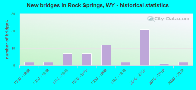
- New bridges - historical statistics
- 21940-1949
- 21950-1959
- 71960-1969
- 71970-1979
- 121980-1989
- 21990-1999
- 212000-2009
- 12010-2019
- 22020-2022
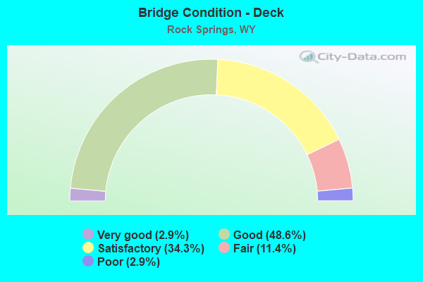
- Bridge Condition - Deck
- 2.9%Very good
- 48.6%Good
- 34.3%Satisfactory
- 11.4%Fair
- 2.9%Poor

- Bridge Condition - Superstructure
- 37.1%Very good
- 40.0%Good
- 14.3%Satisfactory
- 2.9%Fair
- 5.7%Serious
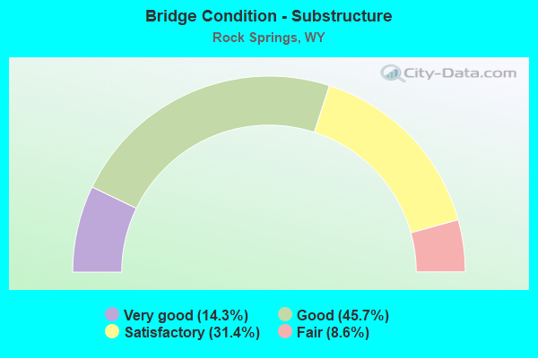
- Bridge Condition - Substructure
- 14.3%Very good
- 45.7%Good
- 31.4%Satisfactory
- 8.6%Fair
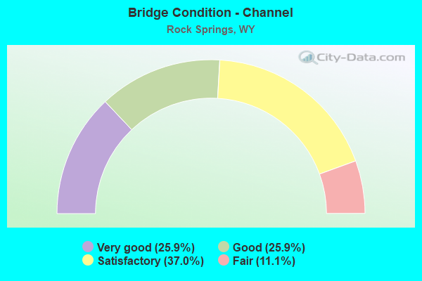
- Bridge Condition - Channel
- 25.9%Very good
- 25.9%Good
- 37.0%Satisfactory
- 11.1%Fair
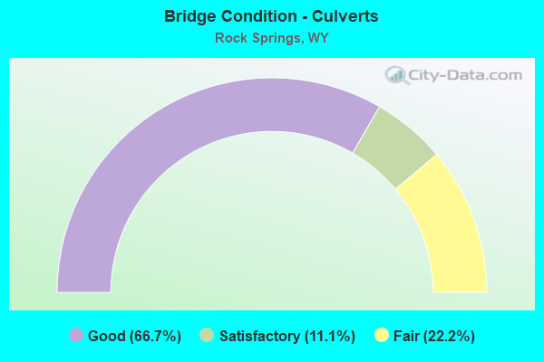
- Bridge Condition - Culverts
- 66.7%Good
- 11.1%Satisfactory
- 22.2%Fair
Find on map >> Show street view
Structure Number: APS, Location: Us 191 Jct - Rock Springs (Lat: 41.576606, Lng: -109.262369), Route carried "on" structure: Interstate 80, Year Built: 1964, Status: Open, Structure Length: 0.96m (3.15ft), Average Daily Traffic: 21,482 (year 2021), Truck Traffic: 34%, Average Future Daily Traffic: 30,075 (year 2041), Design Load: HS 20+Mod, Features Intersected: Alkali Flat
Minimum Vertical Clearance: 30+ m (98+ ft), Kilometerpoint: 164.142, Lanes on structure: 5, Base Highway Network: Yes (Inventory Route: ML8, Subroute: 1), Owner: State Highway Agency, Approaching Roadway Width: 27.4m (89.9ft), Material/Design: Concrete continuous, Design/Construction: Culvert, Number Of Spans In Main Unit: 3, Length of Maximum Span: 3.5m (11.5ft)
Condition: Channel: Satisfactory, Culverts: Fair, Operating Rating: 32.7 metric tons, Method Used To Determine Operating Rating: Field evaluation and documented engineering judgment, Inventory Rating: 32.7 metric tons, Method Used To Determine Inventory Rating: Field evaluation and documented engineering judgment, Structural Evaluation: Somewhat better than minimum adequacy, Waterway Adequacy: Equal to present desirable criteria, Approach Roadway Alignment: Equal to present desirable criteria, Designated Inspection Frequency: Every 24 months, Inspection Date: June 2021
Find on map >> Show street view
Structure Number: APT, Location: Us 191 Jct - Rock Springs (Lat: 41.576197, Lng: -109.262283), Route carried "on" structure: ServiceOther road , Year Built: 1953, Status: Open, Structure Length: 0.96m (3.15ft), Average Daily Traffic: 8,791 (year 2021), Truck Traffic: 1%, Average Future Daily Traffic: 12,307 (year 2041), Features Intersected: Alkali Flat, Facility Carried by Structure: I-80 Service Road
Minimum Vertical Clearance: 30+ m (98+ ft), Kilometerpoint: 4.619, Lanes on structure: 2, Owner: State Highway Agency, Approaching Roadway Width: 9.1m (29.9ft), Material/Design: Concrete continuous, Design/Construction: Culvert, Number Of Spans In Main Unit: 3, Length of Maximum Span: 3.0m (9.8ft)
Condition: Channel: Satisfactory, Culverts: Fair, Operating Rating: 32.7 metric tons, Method Used To Determine Operating Rating: Field evaluation and documented engineering judgment, Inventory Rating: 32.7 metric tons, Method Used To Determine Inventory Rating: Field evaluation and documented engineering judgment, Structural Evaluation: Somewhat better than minimum adequacy, Waterway Adequacy: Equal to present desirable criteria, Approach Roadway Alignment: Equal to present desirable criteria, Designated Inspection Frequency: Every 24 months, Inspection Date: June 2021
Find on map >> Show street view
Structure Number: AQK, Location: Rock Springs - Creston Jt (Lat: 41.610497, Lng: -109.133425), Route carried "on" structure: Interstate 80, Year Built: 1964, Status: Open, Structure Length: 0.96m (3.15ft), Average Daily Traffic: 9,170 (year 2021), Truck Traffic: 44%, Average Future Daily Traffic: 12,838 (year 2041), Design Load: HS 20+Mod, Features Intersected: Gunn Draw
Minimum Vertical Clearance: 30+ m (98+ ft), Kilometerpoint: 178.314, Lanes on structure: 2, Base Highway Network: Yes (Inventory Route: ML8, Subroute: 1), Owner: State Highway Agency, Approaching Roadway Width: 14.0m (45.9ft), Skew: 10 degrees, Material/Design: Concrete continuous, Design/Construction: Culvert, Number Of Spans In Main Unit: 3, Length of Maximum Span: 3.5m (11.5ft)
Condition: Channel: Satisfactory, Culverts: Good, Operating Rating: 32.7 metric tons, Method Used To Determine Operating Rating: Field evaluation and documented engineering judgment, Inventory Rating: 32.7 metric tons, Method Used To Determine Inventory Rating: Field evaluation and documented engineering judgment, Structural Evaluation: Better than present minimum criteria, Waterway Adequacy: Equal to present desirable criteria, Approach Roadway Alignment: Equal to present desirable criteria, Designated Inspection Frequency: Every 24 months, Inspection Date: June 2021
Find on map >> Show street view
Structure Number: AQL, Location: Rock Springs - Creston Jt (Lat: 41.610883, Lng: -109.133692), Route carried "on" structure: Interstate 80, Year Built: 1964, Status: Open, Structure Length: 0.96m (3.15ft), Average Daily Traffic: 7,372 (year 2021), Truck Traffic: 50%, Average Future Daily Traffic: 10,321 (year 2041), Design Load: HS 20+Mod, Features Intersected: Gunn Draw
Minimum Vertical Clearance: 30+ m (98+ ft), Kilometerpoint: 178.079, Lanes on structure: 2, Base Highway Network: Yes (Inventory Route: ML8, Subroute: 1), Owner: State Highway Agency, Approaching Roadway Width: 14.6m (47.9ft), Skew: 10 degrees, Material/Design: Concrete continuous, Design/Construction: Culvert, Number Of Spans In Main Unit: 3, Length of Maximum Span: 3.5m (11.5ft)
Condition: Channel: Satisfactory, Culverts: Good, Operating Rating: 32.7 metric tons, Method Used To Determine Operating Rating: Field evaluation and documented engineering judgment, Inventory Rating: 32.7 metric tons, Method Used To Determine Inventory Rating: Field evaluation and documented engineering judgment, Structural Evaluation: Better than present minimum criteria, Waterway Adequacy: Equal to present desirable criteria, Approach Roadway Alignment: Equal to present desirable criteria, Designated Inspection Frequency: Every 24 months, Inspection Date: June 2021
Find on map >> Show street view
Structure Number: AQM, Location: Rock Springs - Creston Jt (Lat: 41.612769, Lng: -109.127361), Route carried "on" structure: Interstate 80, Year Built: 1964, Status: Open, Structure Length: 3.25m (10.66ft), Average Daily Traffic: 9,170 (year 2021), Truck Traffic: 44%, Average Future Daily Traffic: 12,838 (year 2041), Design Load: HS 20+Mod, Features Intersected: WYO 370
Minimum Vertical Clearance: 30+ m (98+ ft), Kilometerpoint: 178.879, Lanes on structure: 2, Lanes under structure: 2, Base Highway Network: Yes (Inventory Route: ML8, Subroute: 1), Owner: State Highway Agency, Approaching Roadway Width: 11.6m (38.1ft), Skew: 13 degrees, Material/Design: Concrete continuous, Design/Construction: Slab, Number Of Spans In Main Unit: 3, Length of Maximum Span: 13.4m (44.0ft), Curb-To-Curb Width: 11.6m (38.1ft), Out-to-Out Width: 12.5m (41.0ft)
Condition: Deck: Fair, Superstructure: Fair, Substructure: Satisfactory, Operating Rating: 62.6 metric tons, Method Used To Determine Operating Rating: Load Factor (LF), Inventory Rating: 37.2 metric tons, Method Used To Determine Inventory Rating: Load Factor (LF), Structural Evaluation: Somewhat better than minimum adequacy, Deck Geometry: Equal to present minimum criteria, Underclear: High priority of corrective action, Approach Roadway Alignment: Equal to present desirable criteria, Designated Inspection Frequency: Every 24 months, Inspection Date: June 2021, Deck Structure Type: Concrete Cast-file-Place, Wearing Surface/Protective System: Wearing Surface: Bituminous, Membrane: Preformed Fabric
Find on map >> Show street view
Structure Number: AQO, Location: Rock Springs - Creston Jt (Lat: 41.647186, Lng: -109.016931), Route carried "on" structure: Interstate 80, Year Built: 1964, Status: Open, Structure Length: 0.63m (2.07ft), Average Daily Traffic: 8,200 (year 2021), Truck Traffic: 53%, Average Future Daily Traffic: 11,480 (year 2041), Design Load: HS 20+Mod, Features Intersected: Dry Lake
Minimum Vertical Clearance: 30+ m (98+ ft), Kilometerpoint: 188.919, Lanes on structure: 2, Base Highway Network: Yes (Inventory Route: ML8, Subroute: 1), Owner: State Highway Agency, Approaching Roadway Width: 12.2m (40.0ft), Skew: 10 degrees, Material/Design: Concrete continuous, Design/Construction: Culvert, Number Of Spans In Main Unit: 2, Length of Maximum Span: 3.0m (9.8ft)
Condition: Channel: Very good, Culverts: Good, Operating Rating: 32.7 metric tons, Method Used To Determine Operating Rating: Field evaluation and documented engineering judgment, Inventory Rating: 32.7 metric tons, Method Used To Determine Inventory Rating: Field evaluation and documented engineering judgment, Structural Evaluation: Better than present minimum criteria, Waterway Adequacy: Equal to present desirable criteria, Approach Roadway Alignment: Equal to present desirable criteria, Designated Inspection Frequency: Every 24 months, Inspection Date: June 2021
Find on map >> Show street view
Structure Number: AQP, Location: Rock Springs - Creston Jt (Lat: 41.647547, Lng: -109.017208), Route carried "on" structure: Interstate 80, Year Built: 1964, Status: Open, Structure Length: 0.63m (2.07ft), Average Daily Traffic: 8,005 (year 2021), Truck Traffic: 44%, Average Future Daily Traffic: 11,207 (year 2041), Design Load: HS 20+Mod, Features Intersected: Dry Lake
Minimum Vertical Clearance: 30+ m (98+ ft), Kilometerpoint: 188.681, Lanes on structure: 2, Base Highway Network: Yes (Inventory Route: ML8, Subroute: 1), Owner: State Highway Agency, Approaching Roadway Width: 12.2m (40.0ft), Skew: 10 degrees, Material/Design: Concrete continuous, Design/Construction: Culvert, Number Of Spans In Main Unit: 2, Length of Maximum Span: 3.0m (9.8ft)
Condition: Channel: Satisfactory, Culverts: Good, Operating Rating: 32.7 metric tons, Method Used To Determine Operating Rating: Field evaluation and documented engineering judgment, Inventory Rating: 32.7 metric tons, Method Used To Determine Inventory Rating: Field evaluation and documented engineering judgment, Structural Evaluation: Better than present minimum criteria, Waterway Adequacy: Equal to present desirable criteria, Approach Roadway Alignment: Equal to present desirable criteria, Designated Inspection Frequency: Every 24 months, Inspection Date: June 2021
Find on map >> Show street view
Structure Number: CVV, Location: Rock Springs (Lat: 41.576153, Lng: -109.201619), Route carried "on" structure: State highway 430, Year Built: 1959, Status: Open, Structure Length: 0.87m (2.85ft), Average Daily Traffic: 1,266 (year 2021), Truck Traffic: 4%, Average Future Daily Traffic: 1,772 (year 2041), Design Load: HS 20, Features Intersected: Dead Horse Canyon Creek
Minimum Vertical Clearance: 30+ m (98+ ft), Kilometerpoint: 0.505, Lanes on structure: 2, Owner: State Highway Agency, Approaching Roadway Width: 12.2m (40.0ft), Skew: 3 degrees, Material/Design: Concrete continuous, Design/Construction: Culvert, Number Of Spans In Main Unit: 2, Length of Maximum Span: 3.7m (12.1ft)
Condition: Channel: Satisfactory, Culverts: Good, Operating Rating: 32.7 metric tons, Method Used To Determine Operating Rating: Field evaluation and documented engineering judgment, Inventory Rating: 32.7 metric tons, Method Used To Determine Inventory Rating: Field evaluation and documented engineering judgment, Structural Evaluation: Better than present minimum criteria, Waterway Adequacy: Equal to present desirable criteria, Approach Roadway Alignment: Equal to present desirable criteria, Length Of Structure Improvement: 0.82m (2.69ft), Designated Inspection Frequency: Every 24 months, Inspection Date: June 2021, Bridge Improvement Cost: $5,000, Roadway Improvement Cost: $1,000, Total Project Cost: $7,000
Find on map >> Show street view
Structure Number: DBL, Location: Rock Springs Circumferent (Lat: 41.575439, Lng: -109.231653), Route carried "on" structure: State highway 376, Year Built: 1977, Status: Open, Structure Length: 9.11m (29.89ft), Average Daily Traffic: 15,836 (year 2021), Truck Traffic: 1%, Average Future Daily Traffic: 22,170 (year 2041), Design Load: HS 20, Features Intersected: UPRR
Minimum Vertical Clearance: 30+ m (98+ ft), Kilometerpoint: 0.378, Lanes on structure: 2, Owner: State Highway Agency, Approaching Roadway Width: 14.0m (45.9ft), Skew: 2 degrees, Material/Design: Steel continuous, Design/Construction: Stringer/Multi-beam, Number Of Spans In Main Unit: 3, Length of Maximum Span: 47.9m (157.2ft), Curb or Sidewalk Widths: Left: 1.4m (4.6ft), Right: 0.0m, Curb-To-Curb Width: 14.0m (45.9ft), Out-to-Out Width: 16.9m (55.4ft)
Condition: Deck: Good, Superstructure: Good, Substructure: Satisfactory, Operating Rating: 74.4 metric tons, Method Used To Determine Operating Rating: Load Factor (LF), Inventory Rating: 44.5 metric tons, Method Used To Determine Inventory Rating: Load Factor (LF), Structural Evaluation: Equal to present minimum criteria, Deck Geometry: Superior to present desirable criteria, Underclear: Superior to present desirable criteria, Approach Roadway Alignment: Equal to present desirable criteria, Designated Inspection Frequency: Every 24 months, Other Special Inspection Frequency: Every 60 months, Inspection Date: August 2020, Other Special Inspection Date: November 2021, Deck Structure Type: Concrete Cast-file-Place, Wearing Surface/Protective System: Deck Protection: Epoxy Coated Reinforcing
Find on map >> Show street view
Structure Number: DBP, Location: Rock Springs Circumferent (Lat: 41.576419, Lng: -109.234597), Route carried "on" structure: State highway 376, Year Built: 1977, Status: Open, Structure Length: 4.45m (14.60ft), Average Daily Traffic: 15,836 (year 2021), Truck Traffic: 1%, Average Future Daily Traffic: 22,170 (year 2041), Design Load: HS 20, Features Intersected: Bitter Creek
Minimum Vertical Clearance: 30+ m (98+ ft), Kilometerpoint: 0.109, Lanes on structure: 2, Owner: State Highway Agency, Approaching Roadway Width: 14.0m (45.9ft), Skew: 2 degrees, Material/Design: Concrete continuous, Design/Construction: Tee Beam, Number Of Spans In Main Unit: 3, Length of Maximum Span: 17.4m (57.1ft), Curb or Sidewalk Widths: Left: 1.5m (4.9ft), Right: 0.0m, Curb-To-Curb Width: 14.1m (46.3ft), Out-to-Out Width: 16.6m (54.5ft)
Condition: Deck: Satisfactory, Superstructure: Satisfactory, Substructure: Good, Channel: Good, Operating Rating: 49.9 metric tons, Method Used To Determine Operating Rating: Load Factor (LF), Inventory Rating: 29.9 metric tons, Method Used To Determine Inventory Rating: Load Factor (LF), Structural Evaluation: Equal to present minimum criteria, Deck Geometry: Superior to present desirable criteria, Waterway Adequacy: Equal to present desirable criteria, Approach Roadway Alignment: Equal to present desirable criteria, Designated Inspection Frequency: Every 24 months, Inspection Date: Febuary 2022, Deck Structure Type: Concrete Cast-file-Place
Find on map >> Show street view
Structure Number: DCL, Location: Jct I-80 - East (Lat: 41.607008, Lng: -109.134428), Route carried "on" structure: State highway 370, Year Built: 1977, Status: Open, Structure Length: 5.82m (19.09ft), Average Daily Traffic: 1,343 (year 2021), Truck Traffic: 10%, Average Future Daily Traffic: 1,880 (year 2041), Design Load: HS 20, Features Intersected: UPRR
Minimum Vertical Clearance: 30+ m (98+ ft), Kilometerpoint: 1.035, Lanes on structure: 2, Owner: State Highway Agency, Approaching Roadway Width: 9.8m (32.2ft), Material/Design: Steel continuous, Design/Construction: Stringer/Multi-beam, Number Of Spans In Main Unit: 3, Length of Maximum Span: 25.3m (83.0ft), Curb-To-Curb Width: 9.8m (32.2ft), Out-to-Out Width: 10.6m (34.8ft)
Condition: Deck: Good, Superstructure: Good, Substructure: Good, Operating Rating: 49.9 metric tons, Method Used To Determine Operating Rating: Load Factor (LF), Inventory Rating: 29.9 metric tons, Method Used To Determine Inventory Rating: Load Factor (LF), Structural Evaluation: Better than present minimum criteria, Deck Geometry: Somewhat better than minimum adequacy, Underclear: Equal to present minimum criteria, Approach Roadway Alignment: Equal to present minimum criteria, Designated Inspection Frequency: Every 24 months, Inspection Date: June 2021, Deck Structure Type: Concrete Cast-file-Place, Wearing Surface/Protective System: Wearing Surface: Latex Concrete
Find on map >> Show street view
Structure Number: DET, Location: Rock Springs Circumferent (Lat: 41.580097, Lng: -109.205392), Route carried "on" structure: State highway 376, Year Built: 1980, Status: Open, Structure Length: 5.06m (16.60ft), Average Daily Traffic: 1,650 (year 2021), Truck Traffic: 7%, Average Future Daily Traffic: 2,310 (year 2041), Design Load: HS 20, Features Intersected: Machinery Pass
Minimum Vertical Clearance: 30+ m (98+ ft), Kilometerpoint: 4.152, Lanes on structure: 2, Owner: State Highway Agency, Approaching Roadway Width: 14.0m (45.9ft), Material/Design: Steel continuous, Design/Construction: Stringer/Multi-beam, Number Of Spans In Main Unit: 3, Length of Maximum Span: 20.4m (66.9ft), Curb or Sidewalk Widths: Left: 1.5m (4.9ft), Right: 0.0m, Curb-To-Curb Width: 14.0m (45.9ft), Out-to-Out Width: 16.6m (54.5ft)
Condition: Deck: Good, Superstructure: Good, Substructure: Satisfactory, Operating Rating: 52.6 metric tons, Method Used To Determine Operating Rating: Load Factor (LF), Inventory Rating: 31.8 metric tons, Method Used To Determine Inventory Rating: Load Factor (LF), Structural Evaluation: Equal to present minimum criteria, Deck Geometry: Superior to present desirable criteria, Approach Roadway Alignment: Equal to present minimum criteria, Length Of Structure Improvement: 4.88m (16.01ft), Designated Inspection Frequency: Every 24 months, Inspection Date: June 2021, Deck Structure Type: Concrete Cast-file-Place, Wearing Surface/Protective System: Wearing Surface: Latex Concrete
Find on map >> Show street view
Structure Number: DEU, Location: Rock Springs Circumferent (Lat: 41.579000, Lng: -109.206006), Route carried "on" structure: State highway 376, Year Built: 1980, Status: Open, Structure Length: 8.33m (27.33ft), Average Daily Traffic: 1,650 (year 2021), Truck Traffic: 7%, Average Future Daily Traffic: 2,310 (year 2041), Design Load: HS 20, Features Intersected: WYO 430
Minimum Vertical Clearance: 30+ m (98+ ft), Kilometerpoint: 4.019, Lanes on structure: 2, Lanes under structure: 2, Owner: State Highway Agency, Approaching Roadway Width: 14.0m (45.9ft), Material/Design: Steel continuous, Design/Construction: Stringer/Multi-beam, Number Of Spans In Main Unit: 3, Length of Maximum Span: 34.1m (111.9ft), Curb or Sidewalk Widths: Left: 1.5m (4.9ft), Right: 0.0m, Curb-To-Curb Width: 14.0m (45.9ft), Out-to-Out Width: 16.6m (54.5ft)
Condition: Deck: Satisfactory, Superstructure: Good, Substructure: Fair, Channel: Fair, Operating Rating: 56.5 metric tons, Method Used To Determine Operating Rating: Load Factor (LF), Inventory Rating: 33.9 metric tons, Method Used To Determine Inventory Rating: Load Factor (LF), Structural Evaluation: Somewhat better than minimum adequacy, Deck Geometry: Superior to present desirable criteria, Underclear: Superior to present desirable criteria, Waterway Adequacy: Equal to present desirable criteria, Approach Roadway Alignment: Better than present minimum criteria, Length Of Structure Improvement: 8.23m (27.00ft), Designated Inspection Frequency: Every 24 months, Inspection Date: June 2021, Deck Structure Type: Concrete Cast-file-Place, Wearing Surface/Protective System: Wearing Surface: Latex Concrete
Find on map >> Show street view
Structure Number: DEW, Location: Rock Springs Circumferent (Lat: 41.593578, Lng: -109.203892), Route carried "on" structure: State highway 376, Year Built: 1981, Status: Open, Structure Length: 19.60m (64.30ft), Average Daily Traffic: 2,770 (year 2021), Truck Traffic: 7%, Average Future Daily Traffic: 3,878 (year 2041), Design Load: HS 20, Features Intersected: UPRR / Bitter Creek
Minimum Vertical Clearance: 30+ m (98+ ft), Kilometerpoint: 6.484, Lanes on structure: 2, Owner: State Highway Agency, Approaching Roadway Width: 14.0m (45.9ft), Skew: 2 degrees, Material/Design: Steel continuous, Design/Construction: Stringer/Multi-beam, Number Of Spans In Main Unit: 5, Length of Maximum Span: 58.2m (190.9ft), Curb or Sidewalk Widths: Left: 1.5m (4.9ft), Right: 0.0m, Curb-To-Curb Width: 14.0m (45.9ft), Out-to-Out Width: 16.6m (54.5ft)
Condition: Deck: Satisfactory, Superstructure: Satisfactory, Substructure: Satisfactory, Channel: Very good, Operating Rating: 59.9 metric tons, Method Used To Determine Operating Rating: Load Factor (LF), Inventory Rating: 36.3 metric tons, Method Used To Determine Inventory Rating: Load Factor (LF), Structural Evaluation: Equal to present minimum criteria, Deck Geometry: Superior to present desirable criteria, Underclear: Superior to present desirable criteria, Waterway Adequacy: Equal to present desirable criteria, Approach Roadway Alignment: Equal to present desirable criteria, Designated Inspection Frequency: Every 24 months, Inspection Date: Febuary 2022, Deck Structure Type: Concrete Cast-file-Place, Wearing Surface/Protective System: Wearing Surface: Latex Concrete
Find on map >> Show street view
Structure Number: DKE, Location: Rock Springs-Bridger Ave (Lat: 41.592797, Lng: -109.216650), Route carried "on" structure: Business US 80, Year Built: 1981, Status: Open, Structure Length: 2.07m (6.79ft), Average Daily Traffic: 10,137 (year 2021), Truck Traffic: 6%, Average Future Daily Traffic: 14,192 (year 2041), Design Load: HS 20, Features Intersected: Bitter Creek
Minimum Vertical Clearance: 30+ m (98+ ft), Kilometerpoint: 169.334, Lanes on structure: 3, Base Highway Network: Yes, Owner: State Highway Agency, Approaching Roadway Width: 14.6m (47.9ft), Material/Design: Steel, Design/Construction: Stringer/Multi-beam, Number Of Spans In Main Unit: 1, Length of Maximum Span: 20.1m (65.9ft), Curb or Sidewalk Widths: Left: 2.1m (6.9ft), Right: 2.1m (6.9ft), Curb-To-Curb Width: 14.6m (47.9ft), Out-to-Out Width: 18.9m (62.0ft)
Condition: Deck: Good, Superstructure: Good, Substructure: Good, Channel: Good, Operating Rating: 47.2 metric tons, Method Used To Determine Operating Rating: Load Factor (LF), Inventory Rating: 28.1 metric tons, Method Used To Determine Inventory Rating: Load Factor (LF), Structural Evaluation: Better than present minimum criteria, Deck Geometry: Somewhat better than minimum adequacy, Waterway Adequacy: Equal to present desirable criteria, Approach Roadway Alignment: Equal to present desirable criteria, Designated Inspection Frequency: Every 24 months, Inspection Date: June 2021, Deck Structure Type: Concrete Cast-file-Place
Find on map >> Show street view
Structure Number: DKG, Location: 2nd Street Rock Springs (Lat: 41.587242, Lng: -109.216136), Route carried "on" structure: City street , Year Built: 1940, Status: Open, Structure Length: 1.07m (3.51ft), Average Daily Traffic: 2,650 (year 2021), Truck Traffic: 4%, Average Future Daily Traffic: 3,710 (year 2041), Features Intersected: Dead Horse Canyon Creek, Facility Carried by Structure: 2nd Street
Minimum Vertical Clearance: 30+ m (98+ ft), Kilometerpoint: 161.692, Lanes on structure: 2, Owner: Town or Township Highway Agency, Approaching Roadway Width: 13.1m (43.0ft), Skew: 5 degrees, Material/Design: Steel, Design/Construction: Culvert, Number Of Spans In Main Unit: 1, Length of Maximum Span: 10.7m (35.1ft), Curb or Sidewalk Widths: Left: 1.5m (4.9ft), Right: 1.5m (4.9ft), Curb-To-Curb Width: 13.1m (43.0ft), Out-to-Out Width: 18.3m (60.0ft)
Condition: Channel: Satisfactory, Culverts: Good, Operating Rating: 54.5 metric tons, Method Used To Determine Operating Rating: Field evaluation and documented engineering judgment, Inventory Rating: 32.7 metric tons, Method Used To Determine Inventory Rating: Field evaluation and documented engineering judgment, Structural Evaluation: Better than present minimum criteria, Deck Geometry: Equal to present minimum criteria, Waterway Adequacy: Equal to present desirable criteria, Approach Roadway Alignment: Equal to present desirable criteria, Length Of Structure Improvement: 2.29m (7.51ft), Designated Inspection Frequency: Every 24 months, Inspection Date: August 2020, Bridge Improvement Cost: $10,000, Roadway Improvement Cost: $8,000, Total Project Cost: $19,000
Find on map >> Show street view
Structure Number: DNR, Location: Jct 1-80 - Jct U-4304 (Lat: 41.592367, Lng: -109.224783), Route carried "on" structure: US 191, Year Built: 1982, Status: Open, Structure Length: 2.01m (6.59ft), Average Daily Traffic: 11,874 (year 2021), Truck Traffic: 6%, Average Future Daily Traffic: 16,624 (year 2041), Design Load: HS 20, Features Intersected: Bitter Creek
Minimum Vertical Clearance: 30+ m (98+ ft), Kilometerpoint: 0.159, Lanes on structure: 5, Base Highway Network: Yes, Owner: State Highway Agency, Approaching Roadway Width: 22.9m (75.1ft), Material/Design: Steel, Design/Construction: Stringer/Multi-beam, Number Of Spans In Main Unit: 1, Length of Maximum Span: 19.2m (63.0ft), Curb or Sidewalk Widths: Left: 2.4m (7.9ft), Right: 1.8m (5.9ft), Curb-To-Curb Width: 22.9m (75.1ft), Out-to-Out Width: 27.7m (90.9ft)
Condition: Deck: Satisfactory, Superstructure: Good, Substructure: Satisfactory, Channel: Good, Operating Rating: 84.4 metric tons, Method Used To Determine Operating Rating: Load Factor (LF), Inventory Rating: 49.9 metric tons, Method Used To Determine Inventory Rating: Load Factor (LF), Structural Evaluation: Equal to present minimum criteria, Deck Geometry: Equal to present minimum criteria, Waterway Adequacy: Equal to present desirable criteria, Approach Roadway Alignment: Equal to present desirable criteria, Designated Inspection Frequency: Every 24 months, Inspection Date: June 2021, Deck Structure Type: Concrete Cast-file-Place, Wearing Surface/Protective System: Wearing Surface: Latex Concrete
Find on map >> Show street view
Structure Number: EOT, Location: Rock Springs Airport Road (Lat: 41.603208, Lng: -109.128900), Route carried "on" structure: US 370, Year Built: 1984, Status: Open, Structure Length: 4.51m (14.80ft), Average Daily Traffic: 1,343 (year 2021), Truck Traffic: 10%, Average Future Daily Traffic: 1,880 (year 2041), Design Load: HS 20, Features Intersected: Bitter Creek
Minimum Vertical Clearance: 30+ m (98+ ft), Kilometerpoint: 1.711, Lanes on structure: 2, Owner: State Highway Agency, Approaching Roadway Width: 9.8m (32.2ft), Material/Design: Steel continuous, Design/Construction: Stringer/Multi-beam, Number Of Spans In Main Unit: 3, Length of Maximum Span: 17.4m (57.1ft), Curb-To-Curb Width: 9.8m (32.2ft), Out-to-Out Width: 10.7m (35.1ft)
Condition: Deck: Satisfactory, Superstructure: Good, Substructure: Good, Channel: Very good, Operating Rating: 68.0 metric tons, Method Used To Determine Operating Rating: Load Factor (LF), Inventory Rating: 40.8 metric tons, Method Used To Determine Inventory Rating: Load Factor (LF), Structural Evaluation: Better than present minimum criteria, Deck Geometry: Somewhat better than minimum adequacy, Waterway Adequacy: Equal to present desirable criteria, Approach Roadway Alignment: Equal to present desirable criteria, Designated Inspection Frequency: Every 24 months, Inspection Date: June 2021, Deck Structure Type: Concrete Cast-file-Place
Find on map >> Show street view
Structure Number: EPH, Location: Rock Springs Streets (Lat: 41.593547, Lng: -109.218164), Route carried "on" structure: City street 390-1, Year Built: 1976, Status: Open, Structure Length: 2.53m (8.30ft), Average Daily Traffic: 397 (year 2021), Truck Traffic: 5%, Average Future Daily Traffic: 556 (year 2041), Design Load: HS 20, Features Intersected: Bitter Creek, Facility Carried by Structure: N. Street
Minimum Vertical Clearance: 30+ m (98+ ft), Kilometerpoint: 161.412, Lanes on structure: 2, Owner: Town or Township Highway Agency, Approaching Roadway Width: 10.4m (34.1ft), Material/Design: Steel, Design/Construction: Stringer/Multi-beam, Number Of Spans In Main Unit: 1, Length of Maximum Span: 24.4m (80.1ft), Curb or Sidewalk Widths: Left: 1.1m (3.6ft), Right: 1.1m (3.6ft), Curb-To-Curb Width: 8.5m (27.9ft), Out-to-Out Width: 11.2m (36.7ft)
Condition: Deck: Poor, Superstructure: Satisfactory, Substructure: Satisfactory, Channel: Satisfactory, Operating Rating: 50.0 metric tons, Method Used To Determine Operating Rating: Load Factor (LF), Inventory Rating: 29.8 metric tons, Method Used To Determine Inventory Rating: Load Factor (LF), Structural Evaluation: Equal to present minimum criteria, Deck Geometry: Equal to present minimum criteria, Waterway Adequacy: Equal to present desirable criteria, Approach Roadway Alignment: Equal to present desirable criteria, Length Of Structure Improvement: 7.16m (23.49ft), Designated Inspection Frequency: Every 24 months, Inspection Date: May 2021, Bridge Improvement Cost: $25,000, Roadway Improvement Cost: $30,000, Total Project Cost: $56,000, Deck Structure Type: Concrete Cast-file-Place
Find on map >> Show street view
Structure Number: ETO, Location: 6.5 Mi.Sw Of Rock Springs (Lat: 41.558597, Lng: -109.277350), Route carried "on" structure: County highway 51, Year Built: 1975, Status: Open, Structure Length: 2.68m (8.79ft), Average Daily Traffic: 1,830 (year 2021), Truck Traffic: 25%, Average Future Daily Traffic: 2,562 (year 2041), Features Intersected: Little Bitter Creek
Minimum Vertical Clearance: 30+ m (98+ ft), Kilometerpoint: 8.314, Lanes on structure: 2, Owner: County Highway Agency, Approaching Roadway Width: 9.1m (29.9ft), Material/Design: Concrete, Design/Construction: Stringer/Multi-beam, Number Of Spans In Main Unit: 3, Length of Maximum Span: 7.3m (24.0ft), Curb-To-Curb Width: 9.6m (31.5ft), Out-to-Out Width: 10.1m (33.1ft)
Condition: Deck: Satisfactory, Superstructure: Serious, Substructure: Satisfactory, Channel: Fair, Operating Rating: 53.5 metric tons, Method Used To Determine Operating Rating: Load Factor (LF), Inventory Rating: 32.7 metric tons, Method Used To Determine Inventory Rating: Load Factor (LF), Structural Evaluation: High priority of corrective action, Deck Geometry: Somewhat better than minimum adequacy, Waterway Adequacy: Equal to present desirable criteria, Approach Roadway Alignment: Equal to present desirable criteria, Length Of Structure Improvement: 2.26m (7.41ft), Designated Inspection Frequency: Every 24 months, Inspection Date: August 2020, Bridge Improvement Cost: $27,000, Roadway Improvement Cost: $1,000, Total Project Cost: $30,000, Deck Structure Type: Concrete Precast Panels, Wearing Surface/Protective System: Wearing Surface: Bituminous
Find on map >> Show street view
Structure Number: ETQ, Location: Rock Springs (Lat: 41.598844, Lng: -109.232378), Route carried "on" structure: City street 390-2, Year Built: 1975, Status: Open, Structure Length: 1.92m (6.30ft), Average Daily Traffic: 1,242 (year 2021), Truck Traffic: 10%, Average Future Daily Traffic: 1,739 (year 2041), Design Load: HS 20, Features Intersected: Killpecker Creek, Facility Carried by Structure: Spring Drive
Minimum Vertical Clearance: 30+ m (98+ ft), Kilometerpoint: 162.576, Lanes on structure: 2, Owner: Town or Township Highway Agency, Approaching Roadway Width: 7.9m (25.9ft), Material/Design: Steel, Design/Construction: Stringer/Multi-beam, Number Of Spans In Main Unit: 1, Length of Maximum Span: 18.3m (60.0ft), Curb or Sidewalk Widths: Left: 0.2m (0.7ft), Right: 1.5m (4.9ft), Curb-To-Curb Width: 7.9m (25.9ft), Out-to-Out Width: 10.1m (33.1ft)
Condition: Deck: Fair, Superstructure: Satisfactory, Substructure: Good, Channel: Good, Operating Rating: 49.9 metric tons, Method Used To Determine Operating Rating: Allowable Stress (AS), Inventory Rating: 29.0 metric tons, Method Used To Determine Inventory Rating: Allowable Stress (AS), Structural Evaluation: Equal to present minimum criteria, Deck Geometry: Meets minimum limits, Waterway Adequacy: Equal to present desirable criteria, Approach Roadway Alignment: Equal to present minimum criteria, Length Of Structure Improvement: 2.62m (8.60ft), Designated Inspection Frequency: Every 24 months, Inspection Date: May 2021, Bridge Improvement Cost: $13,000, Roadway Improvement Cost: $30,000, Total Project Cost: $44,000 ( Estimate for 2015), Deck Structure Type: Concrete Cast-file-Place
Find on map >> Show street view
Structure Number: FGA, Location: Rock Springs Streets (Lat: 41.609550, Lng: -109.232072), Route carried "on" structure: City street 4313, Year Built: 1987, Status: Open, Structure Length: 4.15m (13.62ft), Average Daily Traffic: 210 (year 2021), Truck Traffic: 8%, Average Future Daily Traffic: 294 (year 2041), Design Load: HS 20, Features Intersected: Killpecker Creek, Facility Carried by Structure: Stagecoach Blvd.
Minimum Vertical Clearance: 30+ m (98+ ft), Kilometerpoint: 160.748, Lanes on structure: 3, Owner: Town or Township Highway Agency, Approaching Roadway Width: 14.0m (45.9ft), Skew: 2 degrees, Material/Design: Steel continuous, Design/Construction: Stringer/Multi-beam, Number Of Spans In Main Unit: 3, Length of Maximum Span: 15.5m (50.9ft), Curb or Sidewalk Widths: Left: 1.5m (4.9ft), Right: 1.5m (4.9ft), Curb-To-Curb Width: 14.0m (45.9ft), Out-to-Out Width: 20.3m (66.6ft)
Condition: Deck: Satisfactory, Superstructure: Good, Substructure: Good, Channel: Good, Operating Rating: 55.3 metric tons, Method Used To Determine Operating Rating: Allowable Stress (AS), Inventory Rating: 35.4 metric tons, Method Used To Determine Inventory Rating: Allowable Stress (AS), Structural Evaluation: Better than present minimum criteria, Deck Geometry: Somewhat better than minimum adequacy, Waterway Adequacy: Equal to present desirable criteria, Approach Roadway Alignment: Equal to present desirable criteria, Designated Inspection Frequency: Every 24 months, Inspection Date: May 2021, Deck Structure Type: Concrete Cast-file-Place, Wearing Surface/Protective System: Deck Protection: Epoxy Coated Reinforcing
Find on map >> Show street view
Structure Number: FHW, Location: Rock Springs Marginal (Lat: 41.597264, Lng: -109.241650), Route carried "on" structure: City street 4301, Year Built: 1989, Status: Open, Structure Length: 7.67m (25.16ft), Average Daily Traffic: 5,526 (year 2021), Truck Traffic: 4%, Average Future Daily Traffic: 7,736 (year 2041), Design Load: HS 20, Features Intersected: I-80, Facility Carried by Structure: College Drive
Minimum Vertical Clearance: 30+ m (98+ ft), Kilometerpoint: 163.902, Lanes on structure: 5, Lanes under structure: 5, Owner: State Highway Agency, Approaching Roadway Width: 20.1m (65.9ft), Material/Design: Steel continuous, Design/Construction: Stringer/Multi-beam, Number Of Spans In Main Unit: 2, Length of Maximum Span: 38.3m (125.7ft), Curb or Sidewalk Widths: Left: 1.5m (4.9ft), Right: 1.5m (4.9ft), Curb-To-Curb Width: 20.1m (65.9ft), Out-to-Out Width: 24.5m (80.4ft)
Condition: Deck: Fair, Superstructure: Good, Substructure: Fair, Operating Rating: 59.9 metric tons, Method Used To Determine Operating Rating: Load Factor (LF), Inventory Rating: 35.4 metric tons, Method Used To Determine Inventory Rating: Load Factor (LF), Structural Evaluation: Somewhat better than minimum adequacy, Deck Geometry: Somewhat better than minimum adequacy, Underclear: Equal to present minimum criteria, Approach Roadway Alignment: Equal to present desirable criteria, Designated Inspection Frequency: Every 24 months, Inspection Date: June 2021, Deck Structure Type: Concrete Cast-file-Place, Wearing Surface/Protective System: Wearing Surface: Epoxy Overlay, Deck Protection: Epoxy Coated Reinforcing
Find on map >> Show street view
Structure Number: FJL, Location: County Road 51 (Lat: 41.570419, Lng: -109.235847), Route carried "on" structure: City street 4302, Year Built: 1975, Status: Open, Structure Length: 2.26m (7.41ft), Average Daily Traffic: 2,386 (year 2021), Truck Traffic: 10%, Average Future Daily Traffic: 3,340 (year 2041), Design Load: HS 20, Features Intersected: Sweetwater Creek, Facility Carried by Structure: Sw Cnty Rd 51
Minimum Vertical Clearance: 30+ m (98+ ft), Kilometerpoint: 4.485, Lanes on structure: 2, Owner: County Highway Agency, Approaching Roadway Width: 9.4m (30.8ft), Material/Design: Concrete, Design/Construction: Stringer/Multi-beam, Number Of Spans In Main Unit: 3, Length of Maximum Span: 7.3m (24.0ft), Curb-To-Curb Width: 9.6m (31.5ft), Out-to-Out Width: 10.1m (33.1ft)
Condition: Deck: Satisfactory, Superstructure: Serious, Substructure: Satisfactory, Channel: Good, Operating Rating: 51.7 metric tons, Method Used To Determine Operating Rating: Load Factor (LF), Inventory Rating: 30.8 metric tons, Method Used To Determine Inventory Rating: Load Factor (LF), Structural Evaluation: High priority of corrective action, Deck Geometry: Meets minimum limits, Waterway Adequacy: Equal to present desirable criteria, Approach Roadway Alignment: Equal to present desirable criteria, Length Of Structure Improvement: 2.26m (7.41ft), Designated Inspection Frequency: Every 12 months, Inspection Date: May 2021, Bridge Improvement Cost: $20,000, Roadway Improvement Cost: $1,000, Total Project Cost: $22,000, Deck Structure Type: Concrete Precast Panels, Wearing Surface/Protective System: Wearing Surface: Bituminous
Find on map >> Show street view
Structure Number: FSE, Location: Rock Springs-Dewar Drive (Lat: 41.584472, Lng: -109.226928), Route carried "on" structure: Business US 80, Year Built: 1991, Status: Open, Structure Length: 3.95m (12.96ft), Average Daily Traffic: 18,381 (year 2021), Truck Traffic: 6%, Average Future Daily Traffic: 25,733 (year 2041), Design Load: HS 20, Features Intersected: Bitter Creek
Minimum Vertical Clearance: 30+ m (98+ ft), Kilometerpoint: 167.811, Lanes on structure: 5, Base Highway Network: Yes, Owner: State Highway Agency, Approaching Roadway Width: 19.5m (64.0ft), Skew: 1 degrees, Material/Design: Steel continuous, Design/Construction: Stringer/Multi-beam, Number Of Spans In Main Unit: 3, Length of Maximum Span: 15.2m (49.9ft), Curb or Sidewalk Widths: Left: 2.1m (6.9ft), Right: 2.1m (6.9ft), Curb-To-Curb Width: 19.5m (64.0ft), Out-to-Out Width: 24.0m (78.7ft)
Condition: Deck: Satisfactory, Superstructure: Good, Substructure: Satisfactory, Channel: Very good, Operating Rating: 59.0 metric tons, Method Used To Determine Operating Rating: Load Factor (LF), Inventory Rating: 35.4 metric tons, Method Used To Determine Inventory Rating: Load Factor (LF), Structural Evaluation: Equal to present minimum criteria, Deck Geometry: Meets minimum limits, Waterway Adequacy: Equal to present desirable criteria, Approach Roadway Alignment: Equal to present minimum criteria, Designated Inspection Frequency: Every 24 months, Inspection Date: June 2021, Deck Structure Type: Concrete Cast-file-Place, Wearing Surface/Protective System: Wearing Surface: Epoxy Overlay
Find on map >> Show street view
Structure Number: KIP, Location: Rock Springs (Lat: 41.582164, Lng: -109.210917), Route carried "on" structure: City street 4314, Year Built: 1995, Status: Open, Structure Length: 1.20m (3.94ft), Average Daily Traffic: 1,964 (year 2021), Truck Traffic: 8%, Average Future Daily Traffic: 2,750 (year 2041), Design Load: HS 25 or greater, Features Intersected: Dead Horse Canyon Creek, Facility Carried by Structure: Connecticut Ave.
Minimum Vertical Clearance: 30+ m (98+ ft), Kilometerpoint: 159.978, Lanes on structure: 2, Owner: Town or Township Highway Agency, Approaching Roadway Width: 10.8m (35.4ft), Skew: 2 degrees, Material/Design: Concrete, Design/Construction: Culvert, Number Of Spans In Main Unit: 3, Length of Maximum Span: 3.4m (11.2ft), Curb or Sidewalk Widths: Left: 1.3m (4.3ft), Right: 1.3m (4.3ft), Curb-To-Curb Width: 10.8m (35.4ft), Out-to-Out Width: 15.1m (49.5ft)
Condition: Channel: Fair, Culverts: Satisfactory, Operating Rating: 93.1 metric tons, Method Used To Determine Operating Rating: Load Factor (LF), Inventory Rating: 55.9 metric tons, Method Used To Determine Inventory Rating: Load Factor (LF), Structural Evaluation: Equal to present minimum criteria, Deck Geometry: Equal to present minimum criteria, Waterway Adequacy: Better than present minimum criteria, Approach Roadway Alignment: Equal to present desirable criteria, Length Of Structure Improvement: 0.61m (2.00ft), Designated Inspection Frequency: Every 24 months, Inspection Date: May 2021, Bridge Improvement Cost: $2,000, Roadway Improvement Cost: $1,000, Total Project Cost: $4,000
Find on map >> Show street view
Structure Number: LEM, Location: Rock Springs Marginal (Lat: 41.607486, Lng: -109.229825), Route carried "on" structure: Interstate 80, Year Built: 2004, Status: Open, Structure Length: 6.40m (21.00ft), Average Daily Traffic: 10,480 (year 2021), Truck Traffic: 44%, Average Future Daily Traffic: 14,672 (year 2041), Design Load: HS 25 or greater, Features Intersected: US 191
Minimum Vertical Clearance: 30+ m (98+ ft), Kilometerpoint: 168.672, Lanes on structure: 3, Lanes under structure: 5, Base Highway Network: Yes (Inventory Route: ML8, Subroute: 1), Owner: State Highway Agency, Approaching Roadway Width: 14.0m (45.9ft), Skew: 12 degrees, Material/Design: Steel continuous, Design/Construction: Stringer/Multi-beam, Number Of Spans In Main Unit: 3, Length of Maximum Span: 35.1m (115.2ft), Curb-To-Curb Width: 14.0m (45.9ft), Out-to-Out Width: 15.1m (49.5ft)
Condition: Deck: Good, Superstructure: Very good, Substructure: Good, Operating Rating: 68.0 metric tons, Method Used To Determine Operating Rating: Load Factor (LF), Inventory Rating: 40.8 metric tons, Method Used To Determine Inventory Rating: Load Factor (LF), Structural Evaluation: Better than present minimum criteria, Deck Geometry: Meets minimum limits, Underclear: Somewhat better than minimum adequacy, Approach Roadway Alignment: Equal to present desirable criteria, Designated Inspection Frequency: Every 24 months, Inspection Date: June 2021, Deck Structure Type: Concrete Cast-file-Place, Wearing Surface/Protective System: Deck Protection: Epoxy Coated Reinforcing
Find on map >> Show street view
Structure Number: LEN, Location: Rock Springs Marginal (Lat: 41.607708, Lng: -109.229861), Route carried "on" structure: Interstate 80, Year Built: 2005, Status: Open, Structure Length: 6.40m (21.00ft), Average Daily Traffic: 10,443 (year 2021), Truck Traffic: 44%, Average Future Daily Traffic: 14,620 (year 2041), Design Load: HS 25 or greater, Features Intersected: US 191
Minimum Vertical Clearance: 30+ m (98+ ft), Kilometerpoint: 168.440, Lanes on structure: 3, Lanes under structure: 5, Base Highway Network: Yes (Inventory Route: ML8, Subroute: 1), Owner: State Highway Agency, Approaching Roadway Width: 14.0m (45.9ft), Skew: 2 degrees, Material/Design: Steel continuous, Design/Construction: Stringer/Multi-beam, Number Of Spans In Main Unit: 3, Length of Maximum Span: 35.1m (115.2ft), Curb-To-Curb Width: 14.0m (45.9ft), Out-to-Out Width: 15.1m (49.5ft)
Condition: Deck: Good, Superstructure: Very good, Substructure: Good, Operating Rating: 68.0 metric tons, Method Used To Determine Operating Rating: Load Factor (LF), Inventory Rating: 40.8 metric tons, Method Used To Determine Inventory Rating: Load Factor (LF), Structural Evaluation: Better than present minimum criteria, Deck Geometry: Meets minimum limits, Underclear: Somewhat better than minimum adequacy, Approach Roadway Alignment: Equal to present desirable criteria, Designated Inspection Frequency: Every 24 months, Inspection Date: June 2021, Deck Structure Type: Concrete Cast-file-Place, Wearing Surface/Protective System: Deck Protection: Epoxy Coated Reinforcing
Find on map >> Show street view
Structure Number: LRX, Location: W. of Elk St Intchg (Lat: 41.606403, Lng: -109.232664), Route carried "on" structure: Interstate 80, Year Built: 2004, Status: Open, Structure Length: 10.67m (35.01ft), Average Daily Traffic: 10,480 (year 2021), Truck Traffic: 44%, Average Future Daily Traffic: 14,672 (year 2041), Design Load: HS 25 or greater, Features Intersected: UPRR / Killpecker Creek
Minimum Vertical Clearance: 30+ m (98+ ft), Kilometerpoint: 168.407, Lanes on structure: 2, Lanes under structure: 2, Base Highway Network: Yes (Inventory Route: ML8, Subroute: 1), Owner: State Highway Agency, Approaching Roadway Width: 12.2m (40.0ft), Skew: 1 degrees, Material/Design: Steel continuous, Design/Construction: Stringer/Multi-beam, Number Of Spans In Main Unit: 3, Length of Maximum Span: 42.7m (140.1ft), Curb-To-Curb Width: 12.2m (40.0ft), Out-to-Out Width: 13.6m (44.6ft)
Condition: Deck: Good, Superstructure: Good, Substructure: Fair, Channel: Very good, Operating Rating: 89.8 metric tons, Method Used To Determine Operating Rating: Load Factor (LF), Inventory Rating: 54.4 metric tons, Method Used To Determine Inventory Rating: Load Factor (LF), Structural Evaluation: Somewhat better than minimum adequacy, Deck Geometry: Better than present minimum criteria, Underclear: Superior to present desirable criteria, Waterway Adequacy: Equal to present desirable criteria, Approach Roadway Alignment: Equal to present desirable criteria, Designated Inspection Frequency: Every 24 months, Inspection Date: June 2021, Deck Structure Type: Concrete Cast-file-Place, Wearing Surface/Protective System: Wearing Surface: Latex Concrete, Deck Protection: Epoxy Coated Reinforcing
Find on map >> Show street view
Structure Number: LRY, Location: W. of Elk St Intchg (Lat: 41.606608, Lng: -109.232719), Route carried "on" structure: Interstate 80, Year Built: 2005, Status: Open, Structure Length: 10.67m (35.01ft), Average Daily Traffic: 10,443 (year 2021), Truck Traffic: 44%, Average Future Daily Traffic: 14,620 (year 2041), Design Load: HS 25 or greater, Features Intersected: UPRR / Killpecker Creek
Minimum Vertical Clearance: 30+ m (98+ ft), Kilometerpoint: 168.173, Lanes on structure: 2, Lanes under structure: 2, Base Highway Network: Yes (Inventory Route: ML8, Subroute: 1), Owner: State Highway Agency, Approaching Roadway Width: 14.0m (45.9ft), Skew: 1 degrees, Material/Design: Steel continuous, Design/Construction: Stringer/Multi-beam, Number Of Spans In Main Unit: 3, Length of Maximum Span: 42.7m (140.1ft), Curb-To-Curb Width: 14.0m (45.9ft), Out-to-Out Width: 15.4m (50.5ft)
Condition: Deck: Good, Superstructure: Very good, Substructure: Satisfactory, Channel: Satisfactory, Operating Rating: 98.0 metric tons, Method Used To Determine Operating Rating: Load Factor (LF), Inventory Rating: 58.1 metric tons, Method Used To Determine Inventory Rating: Load Factor (LF), Structural Evaluation: Equal to present minimum criteria, Deck Geometry: Superior to present desirable criteria, Underclear: Superior to present desirable criteria, Waterway Adequacy: Equal to present desirable criteria, Approach Roadway Alignment: Equal to present desirable criteria, Designated Inspection Frequency: Every 24 months, Inspection Date: June 2021, Deck Structure Type: Concrete Cast-file-Place, Wearing Surface/Protective System: Deck Protection: Epoxy Coated Reinforcing
Find on map >> Show street view
Structure Number: LUG, Location: Elk Street (Lat: 41.585400, Lng: -109.222075), Route carried "on" structure: City street 430, Year Built: 2006, Status: Open, Structure Length: 17.34m (56.89ft), Average Daily Traffic: 8,515 (year 2021), Truck Traffic: 1%, Average Future Daily Traffic: 11,921 (year 2041), Design Load: HS 25 or greater, Features Intersected: UPRR / S. Main Street, Facility Carried by Structure: A Street
Minimum Vertical Clearance: 30+ m (98+ ft), Kilometerpoint: 160.809, Lanes on structure: 3, Lanes under structure: 2, Owner: Town or Township Highway Agency, Approaching Roadway Width: 15.8m (51.8ft), Material/Design: Steel continuous, Design/Construction: Stringer/Multi-beam, Number Of Spans In Main Unit: 4, Length of Maximum Span: 50.3m (165.0ft), Curb or Sidewalk Widths: Left: 1.5m (4.9ft), Right: 3.0m (9.8ft), Curb-To-Curb Width: 15.8m (51.8ft), Out-to-Out Width: 21.6m (70.9ft)
Condition: Deck: Satisfactory, Superstructure: Good, Substructure: Good, Operating Rating: 89.8 metric tons, Method Used To Determine Operating Rating: Load Factor (LF), Inventory Rating: 59.0 metric tons, Method Used To Determine Inventory Rating: Load Factor (LF), Structural Evaluation: Better than present minimum criteria, Deck Geometry: Better than present minimum criteria, Underclear: Superior to present desirable criteria, Approach Roadway Alignment: Equal to present desirable criteria, Designated Inspection Frequency: Every 24 months, Inspection Date: August 2020, Deck Structure Type: Concrete Cast-file-Place, Wearing Surface/Protective System: Deck Protection: Epoxy Coated Reinforcing
Find on map >> Show street view
Structure Number: LYB, Location: Rock Springs Marginal (Lat: 41.579136, Lng: -109.256375), Route carried "on" structure: Interstate 80, Year Built: 2007, Status: Open, Structure Length: 7.32m (24.02ft), Average Daily Traffic: 21,482 (year 2021), Truck Traffic: 34%, Average Future Daily Traffic: 30,075 (year 2041), Design Load: HL 93, Features Intersected: Dewar Drive
Minimum Vertical Clearance: 30+ m (98+ ft), Kilometerpoint: 164.718, Lanes on structure: 2, Lanes under structure: 5, Base Highway Network: Yes (Inventory Route: ML8, Subroute: 1), Owner: State Highway Agency, Approaching Roadway Width: 12.2m (40.0ft), Skew: 13 degrees, Material/Design: Steel continuous, Design/Construction: Stringer/Multi-beam, Number Of Spans In Main Unit: 3, Length of Maximum Span: 39.6m (129.9ft), Curb-To-Curb Width: 12.2m (40.0ft), Out-to-Out Width: 13.3m (43.6ft)
Condition: Deck: Satisfactory, Superstructure: Very good, Substructure: Good, Operating Rating: 59.9 metric tons, Method Used To Determine Operating Rating: Load Factor (LF), Inventory Rating: 35.4 metric tons, Method Used To Determine Inventory Rating: Load Factor (LF), Structural Evaluation: Better than present minimum criteria, Deck Geometry: Better than present minimum criteria, Underclear: Equal to present minimum criteria, Approach Roadway Alignment: Equal to present desirable criteria, Designated Inspection Frequency: Every 24 months, Inspection Date: June 2021, Deck Structure Type: Concrete Cast-file-Place, Wearing Surface/Protective System: Deck Protection: Epoxy Coated Reinforcing
Find on map >> Show street view
Structure Number: LYC, Location: Rock Springs (Lat: 41.579214, Lng: -109.256639), Route carried "on" structure: Interstate 80, Year Built: 2007, Status: Open, Structure Length: 7.32m (24.02ft), Average Daily Traffic: 10,906 (year 2021), Truck Traffic: 34%, Average Future Daily Traffic: 15,268 (year 2041), Design Load: HL 93, Features Intersected: Dewar Drive
Minimum Vertical Clearance: 30+ m (98+ ft), Kilometerpoint: 164.462, Lanes on structure: 2, Lanes under structure: 5, Base Highway Network: Yes (Inventory Route: ML8, Subroute: 1), Owner: State Highway Agency, Approaching Roadway Width: 12.2m (40.0ft), Skew: 13 degrees, Material/Design: Steel continuous, Design/Construction: Stringer/Multi-beam, Number Of Spans In Main Unit: 3, Length of Maximum Span: 39.6m (129.9ft), Curb-To-Curb Width: 12.2m (40.0ft), Out-to-Out Width: 13.3m (43.6ft)
Condition: Deck: Good, Superstructure: Very good, Substructure: Good, Operating Rating: 59.9 metric tons, Method Used To Determine Operating Rating: Load Factor (LF), Inventory Rating: 35.4 metric tons, Method Used To Determine Inventory Rating: Load Factor (LF), Structural Evaluation: Better than present minimum criteria, Deck Geometry: Better than present minimum criteria, Underclear: Equal to present minimum criteria, Approach Roadway Alignment: Equal to present desirable criteria, Designated Inspection Frequency: Every 24 months, Inspection Date: June 2021, Deck Structure Type: Concrete Cast-file-Place, Wearing Surface/Protective System: Deck Protection: Epoxy Coated Reinforcing
Find on map >> Show street view
Structure Number: LYD, Location: Rock Springs (Lat: 41.598986, Lng: -109.200731), Route carried "on" structure: Interstate 80, Year Built: 2007, Status: Open, Structure Length: 3.96m (12.99ft), Average Daily Traffic: 9,170 (year 2021), Truck Traffic: 44%, Average Future Daily Traffic: 12,838 (year 2041), Design Load: HL 93, Features Intersected: Swanson Drive
Minimum Vertical Clearance: 30+ m (98+ ft), Kilometerpoint: 171.685, Lanes on structure: 2, Lanes under structure: 2, Base Highway Network: Yes (Inventory Route: ML8, Subroute: 1), Owner: State Highway Agency, Approaching Roadway Width: 12.2m (40.0ft), Material/Design: Steel continuous, Design/Construction: Stringer/Multi-beam, Number Of Spans In Main Unit: 3, Length of Maximum Span: 15.2m (49.9ft), Curb-To-Curb Width: 12.2m (40.0ft), Out-to-Out Width: 13.2m (43.3ft)
Condition: Deck: Good, Superstructure: Very good, Substructure: Very good, Operating Rating: 76.2 metric tons, Method Used To Determine Operating Rating: Load Factor (LF), Inventory Rating: 45.4 metric tons, Method Used To Determine Inventory Rating: Load Factor (LF), Structural Evaluation: Equal to present desirable criteria, Deck Geometry: Better than present minimum criteria, Underclear: High priority of corrective action, Approach Roadway Alignment: Equal to present desirable criteria, Designated Inspection Frequency: Every 24 months, Inspection Date: June 2021, Deck Structure Type: Concrete Cast-file-Place, Wearing Surface/Protective System: Deck Protection: Epoxy Coated Reinforcing
Find on map >> Show street view
Structure Number: LYE, Location: Rock Springs (Lat: 41.599033, Lng: -109.200464), Route carried "on" structure: Interstate 80, Year Built: 2008, Status: Open, Structure Length: 3.96m (12.99ft), Average Daily Traffic: 9,432 (year 2021), Truck Traffic: 44%, Average Future Daily Traffic: 13,205 (year 2041), Design Load: HL 93, Features Intersected: Swanson Drive
Minimum Vertical Clearance: 30+ m (98+ ft), Kilometerpoint: 171.487, Lanes on structure: 2, Lanes under structure: 2, Base Highway Network: Yes (Inventory Route: ML8, Subroute: 1), Owner: State Highway Agency, Approaching Roadway Width: 14.0m (45.9ft), Skew: 10 degrees, Material/Design: Steel continuous, Design/Construction: Stringer/Multi-beam, Number Of Spans In Main Unit: 3, Length of Maximum Span: 15.2m (49.9ft), Curb-To-Curb Width: 14.0m (45.9ft), Out-to-Out Width: 15.0m (49.2ft)
Condition: Deck: Good, Superstructure: Very good, Substructure: Good, Operating Rating: 76.2 metric tons, Method Used To Determine Operating Rating: Load Factor (LF), Inventory Rating: 45.4 metric tons, Method Used To Determine Inventory Rating: Load Factor (LF), Structural Evaluation: Better than present minimum criteria, Deck Geometry: Superior to present desirable criteria, Underclear: High priority of corrective action, Approach Roadway Alignment: Equal to present desirable criteria, Designated Inspection Frequency: Every 24 months, Inspection Date: June 2021, Deck Structure Type: Concrete Cast-file-Place, Wearing Surface/Protective System: Deck Protection: Epoxy Coated Reinforcing
Find on map >> Show street view
Structure Number: LYF, Location: Rock Springs (Lat: 41.594461, Lng: -109.197578), Route carried "on" structure: Interstate 80, Year Built: 2007, Status: Open, Structure Length: 4.72m (15.49ft), Average Daily Traffic: 9,170 (year 2021), Truck Traffic: 44%, Average Future Daily Traffic: 12,838 (year 2041), Design Load: HL 93, Features Intersected: 9th Street
Minimum Vertical Clearance: 30+ m (98+ ft), Kilometerpoint: 172.258, Lanes on structure: 2, Lanes under structure: 2, Base Highway Network: Yes (Inventory Route: ML8, Subroute: 1), Owner: State Highway Agency, Approaching Roadway Width: 12.2m (40.0ft), Skew: 10 degrees, Material/Design: Steel continuous, Design/Construction: Stringer/Multi-beam, Number Of Spans In Main Unit: 3, Length of Maximum Span: 18.3m (60.0ft), Curb-To-Curb Width: 12.2m (40.0ft), Out-to-Out Width: 13.3m (43.6ft)
Condition: Deck: Good, Superstructure: Very good, Substructure: Very good, Operating Rating: 73.5 metric tons, Method Used To Determine Operating Rating: Load Factor (LF), Inventory Rating: 43.5 metric tons, Method Used To Determine Inventory Rating: Load Factor (LF), Structural Evaluation: Equal to present desirable criteria, Deck Geometry: Better than present minimum criteria, Underclear: Meets minimum limits, Approach Roadway Alignment: Equal to present desirable criteria, Designated Inspection Frequency: Every 24 months, Inspection Date: June 2021, Deck Structure Type: Concrete Cast-file-Place, Wearing Surface/Protective System: Deck Protection: Epoxy Coated Reinforcing
Find on map >> Show street view
Structure Number: LYG, Location: Rock Springs Marginal (Lat: 41.594589, Lng: -109.197411), Route carried "on" structure: Interstate 80, Year Built: 2008, Status: Open, Structure Length: 4.72m (15.49ft), Average Daily Traffic: 9,432 (year 2021), Truck Traffic: 44%, Average Future Daily Traffic: 13,205 (year 2041), Design Load: HL 93, Features Intersected: 9th Street
Minimum Vertical Clearance: 30+ m (98+ ft), Kilometerpoint: 172.047, Lanes on structure: 2, Lanes under structure: 2, Base Highway Network: Yes (Inventory Route: ML8, Subroute: 1), Owner: State Highway Agency, Approaching Roadway Width: 12.2m (40.0ft), Skew: 10 degrees, Material/Design: Steel continuous, Design/Construction: Stringer/Multi-beam, Number Of Spans In Main Unit: 3, Length of Maximum Span: 18.3m (60.0ft), Curb-To-Curb Width: 12.2m (40.0ft), Out-to-Out Width: 13.3m (43.6ft)
Condition: Deck: Good, Superstructure: Very good, Substructure: Good, Operating Rating: 73.5 metric tons, Method Used To Determine Operating Rating: Load Factor (LF), Inventory Rating: 43.5 metric tons, Method Used To Determine Inventory Rating: Load Factor (LF), Structural Evaluation: Better than present minimum criteria, Deck Geometry: Better than present minimum criteria, Underclear: Equal to present minimum criteria, Approach Roadway Alignment: Equal to present desirable criteria, Designated Inspection Frequency: Every 24 months, Inspection Date: June 2021, Deck Structure Type: Concrete Cast-file-Place, Wearing Surface/Protective System: Deck Protection: Epoxy Coated Reinforcing
Find on map >> Show street view
Structure Number: LYN, Location: I-80 Rock Springs Margina (Lat: 41.607564, Lng: -109.211508), Route carried "on" structure: Interstate 80, Year Built: 2007, Status: Open, Structure Length: 3.96m (12.99ft), Average Daily Traffic: 9,170 (year 2021), Truck Traffic: 44%, Average Future Daily Traffic: 12,838 (year 2041), Design Load: HL 93, Features Intersected: Machinery Pass
Minimum Vertical Clearance: 30+ m (98+ ft), Kilometerpoint: 170.336, Lanes on structure: 2, Base Highway Network: Yes (Inventory Route: ML8, Subroute: 1), Owner: State Highway Agency, Approaching Roadway Width: 12.2m (40.0ft), Skew: 10 degrees, Material/Design: Steel continuous, Design/Construction: Stringer/Multi-beam, Number Of Spans In Main Unit: 3, Length of Maximum Span: 15.2m (49.9ft), Curb-To-Curb Width: 12.2m (40.0ft), Out-to-Out Width: 13.2m (43.3ft)
Condition: Deck: Good, Superstructure: Very good, Substructure: Very good, Operating Rating: 76.2 metric tons, Method Used To Determine Operating Rating: Load Factor (LF), Inventory Rating: 60.8 metric tons, Method Used To Determine Inventory Rating: Load Factor (LF), Structural Evaluation: Equal to present desirable criteria, Deck Geometry: Better than present minimum criteria, Approach Roadway Alignment: Equal to present desirable criteria, Designated Inspection Frequency: Every 24 months, Inspection Date: June 2021, Deck Structure Type: Concrete Cast-file-Place, Wearing Surface/Protective System: Deck Protection: Epoxy Coated Reinforcing
Find on map >> Show street view
Structure Number: LYO, Location: I-80 Rock Springs Margina (Lat: 41.607714, Lng: -109.211369), Route carried "on" structure: Interstate 80, Year Built: 2007, Status: Open, Structure Length: 3.96m (12.99ft), Average Daily Traffic: 9,432 (year 2021), Truck Traffic: 44%, Average Future Daily Traffic: 13,205 (year 2041), Design Load: HL 93, Features Intersected: Machinery Pass
Minimum Vertical Clearance: 30+ m (98+ ft), Kilometerpoint: 170.122, Lanes on structure: 2, Base Highway Network: Yes (Inventory Route: ML8, Subroute: 1), Owner: State Highway Agency, Approaching Roadway Width: 12.2m (40.0ft), Skew: 10 degrees, Material/Design: Steel continuous, Design/Construction: Stringer/Multi-beam, Number Of Spans In Main Unit: 3, Length of Maximum Span: 15.2m (49.9ft), Curb-To-Curb Width: 12.2m (40.0ft), Out-to-Out Width: 13.2m (43.3ft)
Condition: Deck: Good, Superstructure: Very good, Substructure: Very good, Operating Rating: 50.2 metric tons, Method Used To Determine Operating Rating: Load and Resistance Factor Rating (LRFR) rating reported by rating factor(RF) method using HL-93 loadings, Inventory Rating: 33.4 metric tons, Method Used To Determine Inventory Rating: Load and Resistance Factor Rating (LRFR) rating reported by rating factor(RF) method using HL-93 loadings, Structural Evaluation: Equal to present desirable criteria, Deck Geometry: Better than present minimum criteria, Approach Roadway Alignment: Equal to present desirable criteria, Designated Inspection Frequency: Every 24 months, Inspection Date: June 2021, Deck Structure Type: Concrete Cast-file-Place, Wearing Surface/Protective System: Deck Protection: Epoxy Coated Reinforcing
Find on map >> Show street view
Structure Number: MFY, Location: Rock Springs (Lat: 41.587947, Lng: -109.227408), Route carried "on" structure: City street , Year Built: 2010, Status: Open, Structure Length: 3.64m (11.94ft), Average Daily Traffic: 4,877 (year 2021), Truck Traffic: 10%, Average Future Daily Traffic: 6,828 (year 2041), Design Load: HL 93, Features Intersected: Bitter Creek, Facility Carried by Structure: Grant Street
Minimum Vertical Clearance: 30+ m (98+ ft), Kilometerpoint: 161.197, Lanes on structure: 3, Owner: Town or Township Highway Agency, Approaching Roadway Width: 15.2m (49.9ft), Skew: 3 degrees, Material/Design: Steel, Design/Construction: Stringer/Multi-beam, Number Of Spans In Main Unit: 1, Length of Maximum Span: 35.7m (117.1ft), Curb or Sidewalk Widths: Left: 2.6m (8.5ft), Right: 0.0m, Curb-To-Curb Width: 16.4m (53.8ft), Out-to-Out Width: 20.0m (65.6ft)
Condition: Deck: Good, Superstructure: Good, Substructure: Good, Channel: Very good, Operating Rating: 78.0 metric tons, Method Used To Determine Operating Rating: Load Factor (LF), Inventory Rating: 59.9 metric tons, Method Used To Determine Inventory Rating: Load Factor (LF), Structural Evaluation: Better than present minimum criteria, Deck Geometry: Better than present minimum criteria, Waterway Adequacy: Equal to present desirable criteria, Approach Roadway Alignment: Better than present minimum criteria, Designated Inspection Frequency: Every 24 months, Inspection Date: August 2020, Deck Structure Type: Concrete Cast-file-Place, Wearing Surface/Protective System: Deck Protection: Epoxy Coated Reinforcing
Find on map >> Show street view
Structure Number: MHG, Location: Rock Springs (Lat: 41.617203, Lng: -109.241533), Route carried "on" structure: City street , Year Built: 2009, Status: Open, Structure Length: 4.39m (14.40ft), Average Daily Traffic: 1,649 (year 2021), Truck Traffic: 10%, Average Future Daily Traffic: 2,309 (year 2041), Design Load: HL 93, Features Intersected: Killpecker Creek, Facility Carried by Structure: Industrial Drive
Minimum Vertical Clearance: 30+ m (98+ ft), Kilometerpoint: 161.202, Lanes on structure: 2, Owner: Town or Township Highway Agency, Approaching Roadway Width: 9.8m (32.2ft), Skew: 4 degrees, Material/Design: Steel, Design/Construction: Stringer/Multi-beam, Number Of Spans In Main Unit: 1, Length of Maximum Span: 42.7m (140.1ft), Curb or Sidewalk Widths: Left: 1.2m (3.9ft), Right: 2.4m (7.9ft), Curb-To-Curb Width: 11.0m (36.1ft), Out-to-Out Width: 15.8m (51.8ft)
Condition: Deck: Satisfactory, Superstructure: Good, Substructure: Good, Channel: Very good, Operating Rating: 51.7 metric tons, Method Used To Determine Operating Rating: Load Factor (LF), Inventory Rating: 30.8 metric tons, Method Used To Determine Inventory Rating: Load Factor (LF), Structural Evaluation: Better than present minimum criteria, Deck Geometry: Equal to present minimum criteria, Waterway Adequacy: Equal to present desirable criteria, Approach Roadway Alignment: Equal to present desirable criteria, Designated Inspection Frequency: Every 24 months, Inspection Date: August 2020, Deck Structure Type: Concrete Cast-file-Place, Wearing Surface/Protective System: Wearing Surface: Latex Concrete, Deck Protection: Epoxy Coated Reinforcing
Find on map >> Show street view
Structure Number: MHT, Location: 1 Mile North Of Rock Spri (Lat: 41.623717, Lng: -109.236433), Route carried "on" structure: County highway 58, Year Built: 2009, Status: Open, Structure Length: 2.74m (8.99ft), Average Daily Traffic: 5,675 (year 2021), Truck Traffic: 4%, Average Future Daily Traffic: 7,945 (year 2041), Design Load: HL 93, Features Intersected: Killpecker Creek
Minimum Vertical Clearance: 30+ m (98+ ft), Kilometerpoint: 0.422, Lanes on structure: 2, Owner: County Highway Agency, Approaching Roadway Width: 14.0m (45.9ft), Material/Design: Concrete, Design/Construction: Tee Beam, Number Of Spans In Main Unit: 1, Length of Maximum Span: 26.6m (87.3ft), Curb or Sidewalk Widths: Left: 3.0m (9.8ft), Right: 0.0m, Curb-To-Curb Width: 14.0m (45.9ft), Out-to-Out Width: 17.9m (58.7ft)
Condition: Deck: Good, Superstructure: Very good, Substructure: Good, Channel: Good, Operating Rating: 86.2 metric tons, Method Used To Determine Operating Rating: Load Factor (LF), Inventory Rating: 47.2 metric tons, Method Used To Determine Inventory Rating: Load Factor (LF), Structural Evaluation: Better than present minimum criteria, Deck Geometry: Superior to present desirable criteria, Waterway Adequacy: Equal to present desirable criteria, Approach Roadway Alignment: Equal to present desirable criteria, Designated Inspection Frequency: Every 24 months, Inspection Date: May 2021, Deck Structure Type: Concrete Precast Panels, Wearing Surface/Protective System: Wearing Surface: Latex Concrete, Deck Protection: Epoxy Coated Reinforcing