Bridge Statistics for Redding, California (CA)
Condition, Traffic, Stress, Structural Evaluation, Project Costs
- National Bridge Inventory (NBI) Statistics
- 176Number of bridges
- 1,991ft / 607mTotal length
- $2,387,000Total costs
- 2,506,574Total average daily traffic
- 167,959Total average daily truck traffic
- National Bridge Inventory (NBI) Registered Bridges for Redding
- No street view available for this location
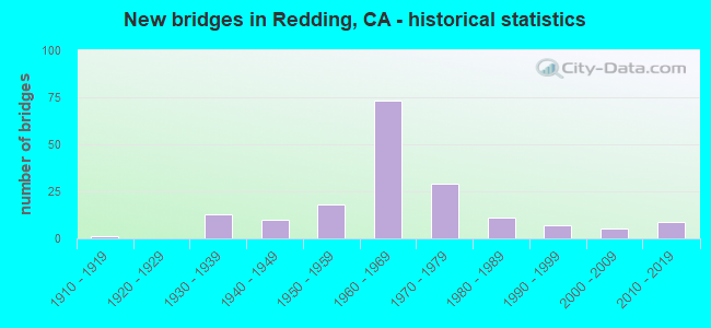
- New bridges - historical statistics
- 11910-1919
- 131930-1939
- 101940-1949
- 181950-1959
- 731960-1969
- 291970-1979
- 111980-1989
- 71990-1999
- 52000-2009
- 92010-2019

- Reconstructed bridges - Historical Statistics
- 11910-1919
- 01920-1929
- 01930-1939
- 21940-1949
- 41950-1959
- 81960-1969
- 21970-1979
- 41980-1989
- 71990-1999
- 72000-2009
- 12010-2019


- Bridge Condition - Deck
- 67.0%Good
- 5.5%Satisfactory
- 24.8%Fair
- 2.8%Poor

- Bridge Condition - Superstructure
- 81.1%Very good
- 4.5%Good
- 12.6%Satisfactory
- 1.8%Fair
- 0.9%Poor

- Bridge Condition - Substructure
- 0.9%Very good
- 83.8%Good
- 2.7%Satisfactory
- 12.6%Fair

- Bridge Condition - Channel
- 12.4%Excellent
- 16.2%Very good
- 26.7%Good
- 31.4%Satisfactory
- 12.4%Fair
- 1.0%Poor

- Bridge Condition - Culverts
- 50.0%Good
- 50.0%Satisfactory
Find on map >> Show street view
Structure Number: SHAS-001, Location: 12 MI NW OF REDDING, CA (Lat: 40.718472, Lng: -122.418972), Route carried "on" structure: ServiceFederal lands road , Year Built: 1943, Status: Open, Structure Length: 11.78m (38.65ft), Average Daily Traffic: 100 (year 2013), Average Future Daily Traffic: 100 (year 2030), Design Load: HS 20, Features Intersected: Shasta Dam Spillway, Facility Carried by Structure: Shasta Dam Blvd
Minimum Vertical Clearance: 30+ m (98+ ft), Kilometerpoint: 0.000, Lanes on structure: 2, Owner: Bureau of Reclamation, Approaching Roadway Width: 9.1m (29.9ft), Material/Design: Steel continuous, Design/Construction: Girder and Floorbeam System, Number Of Spans In Main Unit: 3, Length of Maximum Span: 39.9m (130.9ft), Curb or Sidewalk Widths: Left: 1.8m (5.9ft), Right: 0.6m (2.0ft), Curb-To-Curb Width: 9.1m (29.9ft), Out-to-Out Width: 12.2m (40.0ft)
Condition: Deck: Good, Superstructure: Good, Substructure: Good, Channel: Excellent, Operating Rating: 41.0 metric tons, Method Used To Determine Operating Rating: Load Factor (LF), Inventory Rating: 24.5 metric tons, Method Used To Determine Inventory Rating: Load Factor (LF), Structural Evaluation: Equal to present minimum criteria, Deck Geometry: Better than present minimum criteria, Waterway Adequacy: Superior to present desirable criteria, Approach Roadway Alignment: Equal to present desirable criteria, Designated Inspection Frequency: Every 24 months, Critical Feature Inspection Frequency: Every 24 months, Inspection Date: September 2020, Critical Feature Inspection Date: September 2020, Deck Structure Type: Concrete Cast-file-Place
Find on map >> Show street view
Structure Number: SHAS-003, Location: 4 MI NW OF REDDING, CA (Lat: 40.612258, Lng: -122.444464), Route carried "on" structure: ServiceFederal lands road , Year Built: 1942, Status: Open, Structure Length: 7.32m (24.02ft), Average Daily Traffic: 100 (year 2013), Average Future Daily Traffic: 100 (year 2030), Design Load: HS 20, Features Intersected: KESWICK DAM SPILLWAY, Facility Carried by Structure: Keswick Dam Road
Minimum Vertical Clearance: 30+ m (98+ ft), Kilometerpoint: 0.000, Lanes on structure: 2, Owner: Bureau of Reclamation, Approaching Roadway Width: 6.0m (19.7ft), Material/Design: Concrete, Design/Construction: Tee Beam, Number Of Spans In Main Unit: 4, Length of Maximum Span: 18.3m (60.0ft), Curb or Sidewalk Widths: Left: 0.5m (1.6ft), Right: 0.5m (1.6ft), Curb-To-Curb Width: 6.0m (19.7ft), Out-to-Out Width: 7.6m (24.9ft)
Condition: Deck: Good, Superstructure: Good, Substructure: Good, Channel: Excellent, Operating Rating: 46.0 metric tons, Method Used To Determine Operating Rating: Allowable Stress (AS) rating reported by rating factor (RF) method using MS18 loading, Inventory Rating: 32.4 metric tons, Method Used To Determine Inventory Rating: Allowable Stress (AS) rating reported by rating factor (RF) method using MS18 loading, Structural Evaluation: Better than present minimum criteria, Deck Geometry: Meets minimum limits, Waterway Adequacy: Better than present minimum criteria, Approach Roadway Alignment: Equal to present desirable criteria, Designated Inspection Frequency: Every 48 months, Inspection Date: July 2018, Deck Structure Type: Concrete Cast-file-Place
Find on map >> Show street view
Structure Number: SHAS-004, Location: JF Carr Powerplant (Lat: 40.653167, Lng: -122.625722), Route carried "on" structure: ServiceFederal lands road , Year Built: 1961, Status: Open, Structure Length: 5.13m (16.83ft), Average Daily Traffic: 50 (year 2017), Average Future Daily Traffic: 50 (year 2037), Design Load: HS 20, Features Intersected: Clear Creek, Facility Carried by Structure: South Shore Drive
Minimum Vertical Clearance: 30+ m (98+ ft), Kilometerpoint: 0.000, Lanes on structure: 2, Owner: Bureau of Reclamation, Approaching Roadway Width: 6.1m (20.0ft), Material/Design: Steel continuous, Design/Construction: Stringer/Multi-beam, Number Of Spans In Main Unit: 3, Length of Maximum Span: 18.9m (62.0ft), Curb or Sidewalk Widths: Left: 1.2m (3.9ft), Right: 0.6m (2.0ft), Curb-To-Curb Width: 6.1m (20.0ft), Out-to-Out Width: 7.9m (25.9ft)
Condition: Deck: Good, Superstructure: Very good, Substructure: Very good, Channel: Excellent, Operating Rating: 36.8 metric tons, Method Used To Determine Operating Rating: Load Factor (LF), Inventory Rating: 22.1 metric tons, Method Used To Determine Inventory Rating: Load Factor (LF), Structural Evaluation: Equal to present minimum criteria, Deck Geometry: Somewhat better than minimum adequacy, Waterway Adequacy: Better than present minimum criteria, Approach Roadway Alignment: Better than present minimum criteria, Designated Inspection Frequency: Every 48 months, Inspection Date: May 2021, Deck Structure Type: Concrete Cast-file-Place, Wearing Surface/Protective System: Wearing Surface: Gravel
Find on map >> Show street view
Structure Number: 6 0007, Location: 02-SHA-273-10.97-RDG (Lat: 40.504642, Lng: -122.378506), Route carried "on" structure: State highway 273, Year Built: 1937, Year Reconstructed: 1950, Status: Open, Structure Length: 0.76m (2.49ft), Average Daily Traffic: 21,400 (year 2009), Truck Traffic: 4%, Average Future Daily Traffic: 25,413 (year 2038), Features Intersected: CHINA GULCH
Minimum Vertical Clearance: 30+ m (98+ ft), Kilometerpoint: 10.970, Lanes on structure: 4, Base Highway Network: Yes (Inventory Route: 2, Subroute: 1), Owner: State Highway Agency, Approaching Roadway Width: 19.5m (64.0ft), Skew: 20 degrees, Material/Design: Concrete continuous, Design/Construction: Culvert, Number Of Spans In Main Unit: 2, Length of Maximum Span: 3.5m (11.5ft)
Condition: Channel: Good, Culverts: Satisfactory, Operating Rating: 40.5 metric tons, Method Used To Determine Operating Rating: Field evaluation and documented engineering judgment, Inventory Rating: 24.3 metric tons, Method Used To Determine Inventory Rating: Field evaluation and documented engineering judgment, Structural Evaluation: Equal to present minimum criteria, Waterway Adequacy: Somewhat better than minimum adequacy, Approach Roadway Alignment: Equal to present desirable criteria, Designated Inspection Frequency: Every 24 months, Inspection Date: April 2021
Find on map >> Show street view
Structure Number: 6 0009, Location: 02-SHA-273-12.58-RDG (Lat: 40.527642, Lng: -122.383117), Route carried "on" structure: State highway 273, Year Built: 1940, Year Reconstructed: 1995, Status: Open, Structure Length: 2.38m (7.81ft), Average Daily Traffic: 23,000 (year 2009), Truck Traffic: 4%, Average Future Daily Traffic: 35,164 (year 2038), Design Load: HS 20, Features Intersected: OLNEY CREEK
Minimum Vertical Clearance: 30+ m (98+ ft), Kilometerpoint: 12.580, Lanes on structure: 6, Base Highway Network: Yes (Inventory Route: 2, Subroute: 1), Owner: State Highway Agency, Approaching Roadway Width: 20.1m (65.9ft), Skew: 29 degrees, Material/Design: Concrete continuous, Design/Construction: Slab, Number Of Spans In Main Unit: 3, Length of Maximum Span: 15.2m (49.9ft), Curb or Sidewalk Widths: Left: 1.5m (4.9ft), Right: 0.0m, Curb-To-Curb Width: 29.9m (98.1ft), Out-to-Out Width: 32.5m (106.6ft)
Condition: Deck: Satisfactory, Superstructure: Satisfactory, Substructure: Fair, Channel: Excellent, Operating Rating: 36.6 metric tons, Method Used To Determine Operating Rating: Load Factor (LF), Inventory Rating: 22.0 metric tons, Method Used To Determine Inventory Rating: Load Factor (LF), Structural Evaluation: Somewhat better than minimum adequacy, Deck Geometry: Superior to present desirable criteria, Waterway Adequacy: Better than present minimum criteria, Approach Roadway Alignment: Better than present minimum criteria, Designated Inspection Frequency: Every 24 months, Inspection Date: April 2021, Deck Structure Type: Concrete Cast-file-Place, Wearing Surface/Protective System: Wearing Surface: Bituminous
Find on map >> Show street view
Structure Number: 6 001, Location: 02-SHA-273-13.31-RDG (Lat: 40.538303, Lng: -122.385028), Route carried "on" structure: State highway 273, Year Built: 1942, Year Reconstructed: 1995, Status: Open, Structure Length: 2.44m (8.01ft), Average Daily Traffic: 23,000 (year 2009), Truck Traffic: 4%, Average Future Daily Traffic: 35,164 (year 2038), Design Load: HS 20+Mod, Features Intersected: A.C.I.D. CANAL
Minimum Vertical Clearance: 30+ m (98+ ft), Kilometerpoint: 13.310, Lanes on structure: 4, Base Highway Network: Yes (Inventory Route: 2, Subroute: 1), Owner: State Highway Agency, Approaching Roadway Width: 22.6m (74.1ft), Skew: 4 degrees, Material/Design: Concrete continuous, Design/Construction: Slab, Number Of Spans In Main Unit: 4, Length of Maximum Span: 6.0m (19.7ft), Curb-To-Curb Width: 27.4m (89.9ft), Out-to-Out Width: 28.3m (92.8ft)
Condition: Deck: Satisfactory, Superstructure: Satisfactory, Substructure: Good, Channel: Good, Operating Rating: 54.1 metric tons, Method Used To Determine Operating Rating: Assigned rating based on Load Factor Design (LFD) reported in metric tons, Inventory Rating: 32.4 metric tons, Method Used To Determine Inventory Rating: Assigned rating based on Load Factor Design (LFD) reported in metric tons, Structural Evaluation: Equal to present minimum criteria, Deck Geometry: Superior to present desirable criteria, Waterway Adequacy: Better than present minimum criteria, Approach Roadway Alignment: Equal to present desirable criteria, Designated Inspection Frequency: Every 48 months, Inspection Date: April 2021, Deck Structure Type: Concrete Cast-file-Place
Find on map >> Show street view
Structure Number: 6 0011, Location: 02-SHA-273-13.88-RDG (Lat: 40.546253, Lng: -122.386433), Route carried "on" structure: State highway 273, Year Built: 1942, Year Reconstructed: 1994, Status: Open, Structure Length: 2.65m (8.69ft), Average Daily Traffic: 23,000 (year 2009), Truck Traffic: 4%, Average Future Daily Traffic: 35,164 (year 2038), Design Load: HS 20+Mod, Features Intersected: OREGON GULCH
Minimum Vertical Clearance: 30+ m (98+ ft), Kilometerpoint: 13.880, Lanes on structure: 4, Base Highway Network: Yes (Inventory Route: 2, Subroute: 1), Owner: State Highway Agency, Approaching Roadway Width: 27.4m (89.9ft), Skew: 20 degrees, Material/Design: Concrete continuous, Design/Construction: Slab, Number Of Spans In Main Unit: 4, Length of Maximum Span: 6.5m (21.3ft), Curb-To-Curb Width: 27.4m (89.9ft), Out-to-Out Width: 28.3m (92.8ft)
Condition: Deck: Good, Superstructure: Good, Substructure: Good, Channel: Excellent, Operating Rating: 54.1 metric tons, Method Used To Determine Operating Rating: Assigned rating based on Load Factor Design (LFD) reported in metric tons, Inventory Rating: 32.4 metric tons, Method Used To Determine Inventory Rating: Assigned rating based on Load Factor Design (LFD) reported in metric tons, Structural Evaluation: Better than present minimum criteria, Deck Geometry: Superior to present desirable criteria, Waterway Adequacy: Equal to present desirable criteria, Approach Roadway Alignment: Equal to present desirable criteria, Designated Inspection Frequency: Every 48 months, Inspection Date: April 2021, Deck Structure Type: Concrete Cast-file-Place
Find on map >> Show street view
Structure Number: 6 0012, Location: 02-SHA-273-14.31-RDG (Lat: 40.552539, Lng: -122.387542), Route carried "on" structure: State highway 273, Year Built: 1942, Year Reconstructed: 1995, Status: Open, Structure Length: 3.63m (11.91ft), Average Daily Traffic: 23,000 (year 2009), Truck Traffic: 4%, Average Future Daily Traffic: 35,164 (year 2038), Design Load: HS 20+Mod, Features Intersected: CANYON CREEK
Minimum Vertical Clearance: 30+ m (98+ ft), Kilometerpoint: 14.310, Lanes on structure: 5, Base Highway Network: Yes (Inventory Route: 2, Subroute: 1), Owner: State Highway Agency, Approaching Roadway Width: 22.6m (74.1ft), Skew: 9 degrees, Material/Design: Concrete continuous, Design/Construction: Slab, Number Of Spans In Main Unit: 5, Length of Maximum Span: 7.4m (24.3ft), Curb-To-Curb Width: 27.4m (89.9ft), Out-to-Out Width: 28.3m (92.8ft)
Condition: Deck: Good, Superstructure: Good, Substructure: Fair, Channel: Good, Operating Rating: 54.1 metric tons, Method Used To Determine Operating Rating: Assigned rating based on Load Factor Design (LFD) reported in metric tons, Inventory Rating: 32.4 metric tons, Method Used To Determine Inventory Rating: Assigned rating based on Load Factor Design (LFD) reported in metric tons, Structural Evaluation: Somewhat better than minimum adequacy, Deck Geometry: Superior to present desirable criteria, Waterway Adequacy: Equal to present minimum criteria, Approach Roadway Alignment: Better than present minimum criteria, Designated Inspection Frequency: Every 24 months, Inspection Date: April 2021, Deck Structure Type: Concrete Cast-file-Place
Find on map >> Show street view
Structure Number: 6 0014, Location: 02-SHA-273-17.08-RDG (Lat: 40.591206, Lng: -122.392736), Route carried "on" structure: State highway 273, Year Built: 1935, Year Reconstructed: 1961, Status: Open, Structure Length: 24.02m (78.81ft), Average Daily Traffic: 18,750 (year 2009), Truck Traffic: 5%, Average Future Daily Traffic: 31,526 (year 2037), Design Load: HS 20, Features Intersected: SACRAMENTO RIVER
Minimum Vertical Clearance: 30+ m (98+ ft), Kilometerpoint: 17.080, Lanes on structure: 4, Base Highway Network: Yes (Inventory Route: 2, Subroute: 1), Owner: State Highway Agency, Approaching Roadway Width: 18.3m (60.0ft), Skew: 32 degrees, Material/Design: Steel continuous, Design/Construction: Stringer/Multi-beam, Number Of Spans In Main Unit: 8, Length of Maximum Span: 32.9m (107.9ft), Curb or Sidewalk Widths: Left: 1.5m (4.9ft), Right: 1.5m (4.9ft), Curb-To-Curb Width: 17.2m (56.4ft), Out-to-Out Width: 22.8m (74.8ft)
Condition: Deck: Fair, Superstructure: Good, Substructure: Fair, Channel: Very good, Operating Rating: 48.6 metric tons, Method Used To Determine Operating Rating: Load Factor (LF), Inventory Rating: 29.2 metric tons, Method Used To Determine Inventory Rating: Load Factor (LF), Structural Evaluation: Somewhat better than minimum adequacy, Deck Geometry: Somewhat better than minimum adequacy, Waterway Adequacy: Equal to present desirable criteria, Approach Roadway Alignment: Equal to present minimum criteria, Designated Inspection Frequency: Every 24 months, Critical Feature Inspection Frequency: Every 24 months, Other Special Inspection Frequency: Every 48 months, Inspection Date: May 2020, Critical Feature Inspection Date: October 2021, Other Special Inspection Date: October 2021, Deck Structure Type: Concrete Cast-file-Place, Wearing Surface/Protective System: Wearing Surface: Integral Concrete
Find on map >> Show street view
Structure Number: 6 0022, Location: 02-SHA-273-17.97-RDG (Lat: 40.601114, Lng: -122.382281), Route carried "on" structure: State highway 273, Year Built: 1936, Year Reconstructed: 1954, Status: Open, Structure Length: 0.82m (2.69ft), Average Daily Traffic: 25,000 (year 2009), Truck Traffic: 4%, Average Future Daily Traffic: 36,616 (year 2038), Features Intersected: SULPHUR CREEK
Minimum Vertical Clearance: 30+ m (98+ ft), Kilometerpoint: 17.970, Lanes on structure: 6, Base Highway Network: Yes (Inventory Route: 2, Subroute: 1), Owner: State Highway Agency, Approaching Roadway Width: 23.8m (78.1ft), Material/Design: Concrete continuous, Design/Construction: Culvert, Number Of Spans In Main Unit: 2, Length of Maximum Span: 3.7m (12.1ft)
Condition: Channel: Good, Culverts: Satisfactory, Operating Rating: 40.5 metric tons, Method Used To Determine Operating Rating: Field evaluation and documented engineering judgment, Inventory Rating: 24.3 metric tons, Method Used To Determine Inventory Rating: Field evaluation and documented engineering judgment, Structural Evaluation: Equal to present minimum criteria, Waterway Adequacy: Better than present minimum criteria, Approach Roadway Alignment: Equal to present desirable criteria, Designated Inspection Frequency: Every 24 months, Inspection Date: April 2021
Find on map >> Show street view
Structure Number: 6 0035, Location: 02-SHA-299-23.91-RDG (Lat: 40.586808, Lng: -122.395417), Route carried "on" structure: State highway 299, Year Built: 1958, Status: Open, Structure Length: 6.77m (22.21ft), Average Daily Traffic: 19,700 (year 2009), Truck Traffic: 2%, Average Future Daily Traffic: 27,176 (year 2038), Design Load: HS 20, Features Intersected: UP RR, AMTRK, DIVISION
Minimum Vertical Clearance: 30+ m (98+ ft), Kilometerpoint: 23.910, Lanes on structure: 4, Lanes under structure: 2, Base Highway Network: Yes (Inventory Route: 2, Subroute: 1), Owner: State Highway Agency, Approaching Roadway Width: 15.8m (51.8ft), Skew: 20 degrees, Material/Design: Prestressed concrete, Design/Construction: Slab, Number Of Spans In Main Unit: 1, Number Of Approach Spans: 6, Length of Maximum Span: 12.2m (40.0ft), Curb or Sidewalk Widths: Left: 2.2m (7.2ft), Right: 2.2m (7.2ft), Curb-To-Curb Width: 15.8m (51.8ft), Out-to-Out Width: 20.7m (67.9ft)
Condition: Deck: Good, Superstructure: Good, Substructure: Good, Operating Rating: 55.7 metric tons, Method Used To Determine Operating Rating: Load Factor (LF), Inventory Rating: 33.4 metric tons, Method Used To Determine Inventory Rating: Load Factor (LF), Structural Evaluation: Better than present minimum criteria, Deck Geometry: Meets minimum limits, Underclear: High priority of corrective action, Approach Roadway Alignment: Equal to present desirable criteria, Designated Inspection Frequency: Every 24 months, Inspection Date: April 2021, Deck Structure Type: Concrete Cast-file-Place, Wearing Surface/Protective System: Wearing Surface: Integral Concrete
Find on map >> Show street view
Structure Number: 6 0043L, Location: 02-SHA-299-25.71 (Lat: 40.615319, Lng: -122.347019), Route carried "on" structure: State highway 299, Year Built: 1974, Status: Open, Structure Length: 4.82m (15.81ft), Average Daily Traffic: 6,250 (year 2009), Truck Traffic: 8%, Average Future Daily Traffic: 8,038 (year 2038), Design Load: HS 20, Features Intersected: CHURN CREEK
Minimum Vertical Clearance: 30+ m (98+ ft), Kilometerpoint: 25.710, Lanes on structure: 3, Base Highway Network: Yes (Inventory Route: 2, Subroute: 1), Owner: State Highway Agency, Approaching Roadway Width: 11.9m (39.0ft), Skew: 2 degrees, Material/Design: Concrete continuous, Design/Construction: Tee Beam, Number Of Spans In Main Unit: 3, Length of Maximum Span: 17.7m (58.1ft), Curb-To-Curb Width: 17.1m (56.1ft), Out-to-Out Width: 17.7m (58.1ft)
Condition: Deck: Good, Superstructure: Good, Substructure: Good, Channel: Good, Operating Rating: 43.7 metric tons, Method Used To Determine Operating Rating: Load and Resistance Factor Rating (LRFR) rating reported by rating factor(RF) method using HL-93 loadings, Inventory Rating: 33.7 metric tons, Method Used To Determine Inventory Rating: Load and Resistance Factor Rating (LRFR) rating reported by rating factor(RF) method using HL-93 loadings, Structural Evaluation: Better than present minimum criteria, Deck Geometry: Equal to present minimum criteria, Waterway Adequacy: Equal to present desirable criteria, Approach Roadway Alignment: Equal to present desirable criteria, Designated Inspection Frequency: Every 24 months, Inspection Date: April 2021, Deck Structure Type: Concrete Cast-file-Place, Wearing Surface/Protective System: Wearing Surface: Bituminous, Membrane: Preformed Fabric
Find on map >> Show street view
Structure Number: 6 0043R, Location: 02-SHA-299-25.71 (Lat: 40.615050, Lng: -122.346647), Route carried "on" structure: State highway 299, Year Built: 1965, Year Reconstructed: 1974, Status: Open, Structure Length: 3.44m (11.29ft), Average Daily Traffic: 6,250 (year 2009), Truck Traffic: 8%, Average Future Daily Traffic: 8,038 (year 2038), Design Load: HS 20, Features Intersected: CHURN CREEK
Minimum Vertical Clearance: 30+ m (98+ ft), Kilometerpoint: 25.710, Lanes on structure: 3, Base Highway Network: Yes (Inventory Route: 2, Subroute: 1), Owner: State Highway Agency, Approaching Roadway Width: 11.9m (39.0ft), Skew: 2 degrees, Material/Design: Concrete continuous, Design/Construction: Tee Beam, Number Of Spans In Main Unit: 3, Length of Maximum Span: 12.2m (40.0ft), Curb-To-Curb Width: 17.1m (56.1ft), Out-to-Out Width: 17.7m (58.1ft)
Condition: Deck: Good, Superstructure: Good, Substructure: Good, Channel: Excellent, Operating Rating: 59.0 metric tons, Method Used To Determine Operating Rating: Load Factor (LF), Inventory Rating: 35.6 metric tons, Method Used To Determine Inventory Rating: Load Factor (LF), Structural Evaluation: Better than present minimum criteria, Deck Geometry: Equal to present minimum criteria, Waterway Adequacy: Better than present minimum criteria, Approach Roadway Alignment: Equal to present desirable criteria, Designated Inspection Frequency: Every 24 months, Inspection Date: April 2021, Deck Structure Type: Concrete Cast-file-Place, Wearing Surface/Protective System: Wearing Surface: Integral Concrete
Find on map >> Show street view
Structure Number: 6 0088E, Location: 02-SHA-005-R17.32-RDG (Lat: 40.611750, Lng: -122.365722), Route carried "on" structure: Ramp Interstate 5, Year Built: 1965, Year Reconstructed: 1967, Status: Open, Structure Length: 0.70m (2.30ft), Average Daily Traffic: 27,000 (year 2012), Truck Traffic: 16%, Average Future Daily Traffic: 32,000 (year 2037), Features Intersected: BOULDER CREEK
Minimum Vertical Clearance: 30+ m (98+ ft), Kilometerpoint: 17.320, Lanes on structure: 7, Base Highway Network: Yes (, Subroute: 1), Owner: State Highway Agency, Approaching Roadway Width: 25.9m (85.0ft), Skew: 2 degrees, Material/Design: Concrete continuous, Design/Construction: Culvert, Number Of Spans In Main Unit: 2, Length of Maximum Span: 6.1m (20.0ft)
Condition: Channel: Good, Culverts: Satisfactory, Operating Rating: 54.1 metric tons, Method Used To Determine Operating Rating: Field evaluation and documented engineering judgment, Inventory Rating: 32.4 metric tons, Method Used To Determine Inventory Rating: Field evaluation and documented engineering judgment, Structural Evaluation: Equal to present minimum criteria, Waterway Adequacy: Better than present minimum criteria, Approach Roadway Alignment: Equal to present desirable criteria, Designated Inspection Frequency: Every 24 months, Inspection Date: June 2020
Find on map >> Show street view
Structure Number: 6 0099G, Location: 02-SHA-005-R15.31-RDG (Lat: 40.583500, Lng: -122.358081), Route carried "on" structure: Ramp Interstate 5, Year Built: 1968, Status: Open, Structure Length: 4.27m (14.01ft), Average Daily Traffic: 1,900 (year 2012), Truck Traffic: 2%, Average Future Daily Traffic: 2,200 (year 2037), Design Load: HS 20, Features Intersected: HILLTOP DR
Minimum Vertical Clearance: 30+ m (98+ ft), Kilometerpoint: 15.310, Lanes on structure: 1, Lanes under structure: 4, Owner: State Highway Agency, Approaching Roadway Width: 6.7m (22.0ft), Skew: 2 degrees, Material/Design: Prestressed concrete, Design/Construction: Stringer/Multi-beam, Number Of Spans In Main Unit: 1, Number Of Approach Spans: 2, Length of Maximum Span: 25.9m (85.0ft), Curb-To-Curb Width: 7.3m (24.0ft), Out-to-Out Width: 7.9m (25.9ft)
Condition: Deck: Good, Superstructure: Good, Substructure: Good, Operating Rating: 29.5 metric tons, Method Used To Determine Operating Rating: Load and Resistance Factor Rating (LRFR) rating reported by rating factor(RF) method using HL-93 loadings, Inventory Rating: 14.3 metric tons, Method Used To Determine Inventory Rating: Load and Resistance Factor Rating (LRFR) rating reported by rating factor(RF) method using HL-93 loadings, Structural Evaluation: High priority of corrective action, Deck Geometry: Better than present minimum criteria, Underclear: Somewhat better than minimum adequacy, Approach Roadway Alignment: Equal to present desirable criteria, Designated Inspection Frequency: Every 24 months, Inspection Date: June 2020, Deck Structure Type: Concrete Cast-file-Place, Wearing Surface/Protective System: Wearing Surface: Bituminous, Membrane: Preformed Fabric
Find on map >> Show street view
Structure Number: 6 0101, Location: 02-SHA-005-R16.15-RDG (Lat: 40.595431, Lng: -122.360956), Route carried "on" structure: City street , Year Built: 1965, Status: Open, Structure Length: 7.27m (23.85ft), Average Daily Traffic: 13,009 (year 2017), Truck Traffic: 1%, Average Future Daily Traffic: 13,509 (year 2041), Design Load: HS 20, Features Intersected: INTERSTATE 5, Facility Carried by Structure: HILLTOP DR
Minimum Vertical Clearance: 30+ m (98+ ft), Kilometerpoint: 0.000, Lanes on structure: 2, Lanes under structure: 5, Owner: State Highway Agency, Approaching Roadway Width: 8.6m (28.2ft), Material/Design: Concrete continuous, Design/Construction: Box Beam or Girders - Multiple, Number Of Spans In Main Unit: 4, Length of Maximum Span: 24.1m (79.1ft), Curb or Sidewalk Widths: Left: 0.0m, Right: 1.3m (4.3ft), Curb-To-Curb Width: 8.6m (28.2ft), Out-to-Out Width: 10.7m (35.1ft)
Condition: Deck: Good, Superstructure: Good, Substructure: Satisfactory, Operating Rating: 36.9 metric tons, Method Used To Determine Operating Rating: Load and Resistance Factor Rating (LRFR) rating reported by rating factor(RF) method using HL-93 loadings, Inventory Rating: 28.5 metric tons, Method Used To Determine Inventory Rating: Load and Resistance Factor Rating (LRFR) rating reported by rating factor(RF) method using HL-93 loadings, Structural Evaluation: Equal to present minimum criteria, Deck Geometry: Meets minimum limits, Underclear: Equal to present minimum criteria, Approach Roadway Alignment: Equal to present minimum criteria, Designated Inspection Frequency: Every 24 months, Inspection Date: June 2020, Deck Structure Type: Concrete Cast-file-Place, Wearing Surface/Protective System: Wearing Surface: Integral Concrete, Deck Protection: Cathodic Protection
Find on map >> Show street view
Structure Number: 6 0106, Location: 02-SHA-044-R0.13-RDG (Lat: 40.585511, Lng: -122.358058), Route carried "on" structure: City street , Year Built: 1968, Year Reconstructed: 2008, Status: Open, Structure Length: 5.59m (18.34ft), Average Daily Traffic: 24,118 (year 1998), Truck Traffic: 8%, Average Future Daily Traffic: 30,375 (year 2035), Design Load: HS 20, Features Intersected: STATE ROUTE 44, Facility Carried by Structure: HILLTOP DR
Minimum Vertical Clearance: 30+ m (98+ ft), Kilometerpoint: 0.000, Lanes on structure: 5, Lanes under structure: 7, Base Highway Network: Yes, Owner: State Highway Agency, Approaching Roadway Width: 24.4m (80.1ft), Material/Design: Prestressed concrete continuous, Design/Construction: Box Beam or Girders - Multiple, Number Of Spans In Main Unit: 2, Length of Maximum Span: 28.7m (94.2ft), Curb or Sidewalk Widths: Left: 0.0m, Right: 1.5m (4.9ft), Curb-To-Curb Width: 24.4m (80.1ft), Out-to-Out Width: 26.7m (87.6ft)
Condition: Deck: Good, Superstructure: Good, Substructure: Good, Operating Rating: 54.1 metric tons, Method Used To Determine Operating Rating: Assigned rating based on Load Factor Design (LFD) reported in metric tons, Inventory Rating: 32.4 metric tons, Method Used To Determine Inventory Rating: Assigned rating based on Load Factor Design (LFD) reported in metric tons, Structural Evaluation: Better than present minimum criteria, Deck Geometry: Superior to present desirable criteria, Underclear: Meets minimum limits, Approach Roadway Alignment: Equal to present minimum criteria, Designated Inspection Frequency: Every 48 months, Inspection Date: May 2018, Deck Structure Type: Concrete Cast-file-Place, Wearing Surface/Protective System: Wearing Surface: Bituminous, Membrane: Preformed Fabric
Find on map >> Show street view
Structure Number: 6 0107, Location: 02-SHA-005-R19.00-RDG (Lat: 40.635875, Lng: -122.366858), Route carried "on" structure: Interstate 5, Year Built: 1953, Year Reconstructed: 2005, Status: Open, Structure Length: 4.23m (13.88ft), Average Daily Traffic: 34,000 (year 2009), Truck Traffic: 17%, Average Future Daily Traffic: 87,106 (year 2042), Design Load: HS 20, Features Intersected: CHURN CREEK
Minimum Vertical Clearance: 30+ m (98+ ft), Kilometerpoint: 19.000, Lanes on structure: 6, Base Highway Network: Yes (, Subroute: 1), Owner: State Highway Agency, Approaching Roadway Width: 40.0m (131.2ft), Skew: 31 degrees, Material/Design: Concrete continuous, Design/Construction: Tee Beam, Number Of Spans In Main Unit: 4, Length of Maximum Span: 10.4m (34.1ft), Curb-To-Curb Width: 38.3m (125.7ft), Out-to-Out Width: 39.8m (130.6ft)
Condition: Deck: Satisfactory, Superstructure: Good, Substructure: Good, Channel: Very good, Operating Rating: 41.1 metric tons, Method Used To Determine Operating Rating: Load and Resistance Factor Rating (LRFR) rating reported by rating factor(RF) method using HL-93 loadings, Inventory Rating: 31.8 metric tons, Method Used To Determine Inventory Rating: Load and Resistance Factor Rating (LRFR) rating reported by rating factor(RF) method using HL-93 loadings, Structural Evaluation: Better than present minimum criteria, Deck Geometry: Superior to present desirable criteria, Waterway Adequacy: Equal to present desirable criteria, Approach Roadway Alignment: Superior to present desirable criteria, Designated Inspection Frequency: Every 24 months, Inspection Date: Febuary 2022, Deck Structure Type: Concrete Cast-file-Place, Wearing Surface/Protective System: Wearing Surface: Integral Concrete, Deck Protection: Epoxy Coated Reinforcing
Find on map >> Show street view
Structure Number: 6 0109, Location: 02-SHA-273-19.09 (Lat: 40.615756, Lng: -122.374369), Route carried "on" structure: State highway 273, Year Built: 1953, Status: Open, Structure Length: 0.67m (2.20ft), Average Daily Traffic: 12,800 (year 2009), Truck Traffic: 9%, Average Future Daily Traffic: 25,020 (year 2043), Features Intersected: BOULDER CREEK
Minimum Vertical Clearance: 30+ m (98+ ft), Kilometerpoint: 19.090, Lanes on structure: 4, Base Highway Network: Yes (Inventory Route: 2, Subroute: 1), Owner: State Highway Agency, Approaching Roadway Width: 32.0m (105.0ft), Skew: 1 degrees, Material/Design: Concrete continuous, Design/Construction: Culvert, Number Of Spans In Main Unit: 2, Length of Maximum Span: 3.0m (9.8ft)
Condition: Channel: Good, Culverts: Satisfactory, Operating Rating: 54.1 metric tons, Method Used To Determine Operating Rating: Field evaluation and documented engineering judgment, Inventory Rating: 32.4 metric tons, Method Used To Determine Inventory Rating: Field evaluation and documented engineering judgment, Structural Evaluation: Equal to present minimum criteria, Waterway Adequacy: Better than present minimum criteria, Approach Roadway Alignment: Equal to present desirable criteria, Designated Inspection Frequency: Every 48 months, Inspection Date: April 2021
Find on map >> Show street view
Structure Number: 6 0122, Location: 02-SHA-005-R12.15-RDG (Lat: 40.538400, Lng: -122.351447), Route carried "on" structure: City street , Year Built: 1965, Year Reconstructed: 1996, Status: Open, Structure Length: 7.84m (25.72ft), Average Daily Traffic: 10,000 (year 2012), Truck Traffic: 5%, Average Future Daily Traffic: 10,569 (year 2041), Design Load: HS 20, Features Intersected: INTERSTATE 5, Facility Carried by Structure: CHURN CREEK ROAD
Minimum Vertical Clearance: 30+ m (98+ ft), Kilometerpoint: 0.000, Lanes on structure: 6, Lanes under structure: 6, Base Highway Network: Yes, Owner: State Highway Agency, Approaching Roadway Width: 28.0m (91.9ft), Skew: 2 degrees, Material/Design: Concrete continuous, Design/Construction: Box Beam or Girders - Multiple, Number Of Spans In Main Unit: 4, Length of Maximum Span: 26.4m (86.6ft), Curb or Sidewalk Widths: Left: 1.8m (5.9ft), Right: 1.8m (5.9ft), Curb-To-Curb Width: 28.0m (91.9ft), Out-to-Out Width: 32.3m (106.0ft)
Condition: Deck: Fair, Superstructure: Satisfactory, Substructure: Good, Operating Rating: 54.1 metric tons, Method Used To Determine Operating Rating: Field evaluation and documented engineering judgment, Inventory Rating: 32.4 metric tons, Method Used To Determine Inventory Rating: Field evaluation and documented engineering judgment, Structural Evaluation: Equal to present minimum criteria, Deck Geometry: Superior to present desirable criteria, Underclear: Meets minimum limits, Approach Roadway Alignment: Equal to present desirable criteria, Designated Inspection Frequency: Every 24 months, Inspection Date: June 2020, Deck Structure Type: Concrete Cast-file-Place
Find on map >> Show street view
Structure Number: 6 0123, Location: 02-SHA-005-R12.92-RDG (Lat: 40.549242, Lng: -122.354894), Route carried "on" structure: City street , Year Built: 1965, Status: Open, Structure Length: 7.12m (23.36ft), Average Daily Traffic: 3,000 (year 2012), Truck Traffic: 1%, Average Future Daily Traffic: 3,800 (year 2037), Design Load: HS 20+Mod, Features Intersected: INTERSTATE 5, Facility Carried by Structure: LOMA VISTA DR
Minimum Vertical Clearance: 30+ m (98+ ft), Kilometerpoint: 0.000, Lanes on structure: 2, Lanes under structure: 6, Owner: State Highway Agency, Approaching Roadway Width: 12.2m (40.0ft), Skew: 1 degrees, Material/Design: Concrete continuous, Design/Construction: Box Beam or Girders - Multiple, Number Of Spans In Main Unit: 4, Length of Maximum Span: 24.6m (80.7ft), Curb or Sidewalk Widths: Left: 1.5m (4.9ft), Right: 1.5m (4.9ft), Curb-To-Curb Width: 9.8m (32.2ft), Out-to-Out Width: 14.0m (45.9ft)
Condition: Deck: Poor, Superstructure: Satisfactory, Substructure: Good, Operating Rating: 41.8 metric tons, Method Used To Determine Operating Rating: Load and Resistance Factor Rating (LRFR) rating reported by rating factor(RF) method using HL-93 loadings, Inventory Rating: 32.1 metric tons, Method Used To Determine Inventory Rating: Load and Resistance Factor Rating (LRFR) rating reported by rating factor(RF) method using HL-93 loadings, Structural Evaluation: Equal to present minimum criteria, Deck Geometry: Meets minimum limits, Underclear: Meets minimum limits, Approach Roadway Alignment: Equal to present desirable criteria, Designated Inspection Frequency: Every 24 months, Inspection Date: June 2020, Deck Structure Type: Concrete Cast-file-Place
Find on map >> Show street view
Structure Number: 6 0124, Location: 02-SHA-005-R13.95-RDG (Lat: 40.563700, Lng: -122.359475), Route carried "on" structure: City street , Year Built: 1965, Year Reconstructed: 1991, Status: Open, Structure Length: 7.45m (24.44ft), Average Daily Traffic: 40,000 (year 2012), Truck Traffic: 1%, Average Future Daily Traffic: 58,000 (year 2037), Design Load: HS 20, Features Intersected: INTERSTATE 5, Facility Carried by Structure: HARTNELL AVE
Minimum Vertical Clearance: 30+ m (98+ ft), Kilometerpoint: 0.000, Lanes on structure: 4, Lanes under structure: 6, Owner: State Highway Agency, Approaching Roadway Width: 17.1m (56.1ft), Skew: 1 degrees, Material/Design: Concrete continuous, Design/Construction: Box Beam or Girders - Multiple, Number Of Spans In Main Unit: 4, Length of Maximum Span: 24.6m (80.7ft), Curb or Sidewalk Widths: Left: 1.5m (4.9ft), Right: 1.5m (4.9ft), Curb-To-Curb Width: 17.1m (56.1ft), Out-to-Out Width: 20.7m (67.9ft)
Condition: Deck: Good, Superstructure: Good, Substructure: Good, Operating Rating: 54.1 metric tons, Method Used To Determine Operating Rating: Field evaluation and documented engineering judgment, Inventory Rating: 32.4 metric tons, Method Used To Determine Inventory Rating: Field evaluation and documented engineering judgment, Structural Evaluation: Better than present minimum criteria, Deck Geometry: Somewhat better than minimum adequacy, Underclear: Somewhat better than minimum adequacy, Approach Roadway Alignment: Equal to present desirable criteria, Designated Inspection Frequency: Every 48 months, Inspection Date: June 2020, Deck Structure Type: Concrete Cast-file-Place, Wearing Surface/Protective System: Wearing Surface: Integral Concrete
Find on map >> Show street view
Structure Number: 6 0125L, Location: 02-SHA-005-R14.44-RDG (Lat: 40.570808, Lng: -122.360558), Route carried "on" structure: Interstate 5, Year Built: 1965, Year Reconstructed: 2012, Status: Open, Structure Length: 5.15m (16.90ft), Average Daily Traffic: 26,500 (year 2009), Truck Traffic: 12%, Average Future Daily Traffic: 47,000 (year 2037), Design Load: HL 93, Features Intersected: EAST CYPRESS AVE
Minimum Vertical Clearance: 30+ m (98+ ft), Kilometerpoint: 14.440, Lanes on structure: 3, Lanes under structure: 7, Base Highway Network: Yes (, Subroute: 1), Owner: State Highway Agency, Approaching Roadway Width: 17.1m (56.1ft), Material/Design: Prestressed concrete, Design/Construction: Stringer/Multi-beam, Number Of Spans In Main Unit: 1, Number Of Approach Spans: 2, Length of Maximum Span: 29.6m (97.1ft), Curb-To-Curb Width: 17.1m (56.1ft), Out-to-Out Width: 18.0m (59.1ft)
Condition: Deck: Fair, Superstructure: Good, Substructure: Good, Operating Rating: 36.6 metric tons, Method Used To Determine Operating Rating: Load and Resistance Factor Rating (LRFR) rating reported by rating factor(RF) method using HL-93 loadings, Inventory Rating: 18.8 metric tons, Method Used To Determine Inventory Rating: Load and Resistance Factor Rating (LRFR) rating reported by rating factor(RF) method using HL-93 loadings, Structural Evaluation: Meets minimum limits, Deck Geometry: Equal to present minimum criteria, Underclear: Meets minimum limits, Approach Roadway Alignment: Equal to present desirable criteria, Designated Inspection Frequency: Every 24 months, Inspection Date: June 2020, Deck Structure Type: Concrete Cast-file-Place, Wearing Surface/Protective System: Wearing Surface: Integral Concrete
Find on map >> Show street view
Structure Number: 6 0125R, Location: 02-SHA-005-R14.44-RDG (Lat: 40.570806, Lng: -122.360217), Route carried "on" structure: Interstate 5, Year Built: 1965, Year Reconstructed: 2012, Status: Open, Structure Length: 5.15m (16.90ft), Average Daily Traffic: 26,500 (year 2009), Truck Traffic: 12%, Average Future Daily Traffic: 47,000 (year 2037), Design Load: HL 93, Features Intersected: EAST CYPRESS AVE
Minimum Vertical Clearance: 30+ m (98+ ft), Kilometerpoint: 14.440, Lanes on structure: 3, Lanes under structure: 8, Base Highway Network: Yes (, Subroute: 1), Owner: State Highway Agency, Approaching Roadway Width: 17.1m (56.1ft), Material/Design: Prestressed concrete, Design/Construction: Stringer/Multi-beam, Number Of Spans In Main Unit: 1, Number Of Approach Spans: 2, Length of Maximum Span: 29.6m (97.1ft), Curb-To-Curb Width: 17.1m (56.1ft), Out-to-Out Width: 18.0m (59.1ft)
Condition: Deck: Fair, Superstructure: Good, Substructure: Good, Operating Rating: 36.9 metric tons, Method Used To Determine Operating Rating: Load and Resistance Factor Rating (LRFR) rating reported by rating factor(RF) method using HL-93 loadings, Inventory Rating: 18.5 metric tons, Method Used To Determine Inventory Rating: Load and Resistance Factor Rating (LRFR) rating reported by rating factor(RF) method using HL-93 loadings, Structural Evaluation: Meets minimum limits, Deck Geometry: Equal to present minimum criteria, Underclear: Meets minimum limits, Approach Roadway Alignment: Equal to present desirable criteria, Designated Inspection Frequency: Every 24 months, Inspection Date: June 2020, Deck Structure Type: Concrete Cast-file-Place, Wearing Surface/Protective System: Wearing Surface: Integral Concrete
Find on map >> Show street view
Structure Number: 6 0126G, Location: 02-SHA-005-R15.43-RDG (Lat: 40.584956, Lng: -122.358453), Route carried "on" structure: Ramp Interstate 5, Year Built: 1965, Status: Open, Structure Length: 6.55m (21.49ft), Average Daily Traffic: 10,000 (year 2012), Truck Traffic: 8%, Average Future Daily Traffic: 20,000 (year 2037), Design Load: HS 20, Features Intersected: STATE ROUTE 44
Minimum Vertical Clearance: 30+ m (98+ ft), Kilometerpoint: 15.430, Lanes on structure: 1, Lanes under structure: 6, Base Highway Network: Yes (, Subroute: 1), Owner: State Highway Agency, Approaching Roadway Width: 8.5m (27.9ft), Material/Design: Concrete continuous, Design/Construction: Tee Beam, Number Of Spans In Main Unit: 4, Length of Maximum Span: 21.0m (68.9ft), Curb or Sidewalk Widths: Left: 0.6m (2.0ft), Right: 0.6m (2.0ft), Curb-To-Curb Width: 8.5m (27.9ft), Out-to-Out Width: 10.4m (34.1ft)
Condition: Deck: Good, Superstructure: Good, Substructure: Good, Operating Rating: 70.0 metric tons, Method Used To Determine Operating Rating: Load Factor (LF), Inventory Rating: 41.8 metric tons, Method Used To Determine Inventory Rating: Load Factor (LF), Structural Evaluation: Better than present minimum criteria, Deck Geometry: Superior to present desirable criteria, Underclear: High priority of corrective action, Approach Roadway Alignment: Better than present minimum criteria, Designated Inspection Frequency: Every 24 months, Inspection Date: June 2020, Deck Structure Type: Concrete Cast-file-Place, Wearing Surface/Protective System: Wearing Surface: Integral Concrete
Find on map >> Show street view
Structure Number: 6 0126L, Location: 02-SHA-005-R15.43-RDG (Lat: 40.585103, Lng: -122.360581), Route carried "on" structure: Interstate 5, Year Built: 1965, Year Reconstructed: 2012, Status: Open, Structure Length: 6.04m (19.82ft), Average Daily Traffic: 26,500 (year 2009), Truck Traffic: 12%, Average Future Daily Traffic: 47,000 (year 2037), Design Load: HL 93, Features Intersected: STATE ROUTE 44
Minimum Vertical Clearance: 30+ m (98+ ft), Kilometerpoint: 15.430, Lanes on structure: 3, Lanes under structure: 5, Base Highway Network: Yes (, Subroute: 1), Owner: State Highway Agency, Approaching Roadway Width: 20.3m (66.6ft), Material/Design: Concrete continuous, Design/Construction: Tee Beam, Number Of Spans In Main Unit: 4, Length of Maximum Span: 19.1m (62.7ft), Curb or Sidewalk Widths: Left: 0.6m (2.0ft), Right: 0.0m, Curb-To-Curb Width: 20.3m (66.6ft), Out-to-Out Width: 21.7m (71.2ft)
Condition: Deck: Fair, Superstructure: Good, Substructure: Good, Operating Rating: 42.1 metric tons, Method Used To Determine Operating Rating: Field evaluation and documented engineering judgment, Inventory Rating: 32.4 metric tons, Method Used To Determine Inventory Rating: Field evaluation and documented engineering judgment, Structural Evaluation: Better than present minimum criteria, Deck Geometry: Superior to present desirable criteria, Underclear: Somewhat better than minimum adequacy, Approach Roadway Alignment: High priority of corrective action, Designated Inspection Frequency: Every 24 months, Inspection Date: June 2020, Deck Structure Type: Concrete Cast-file-Place, Wearing Surface/Protective System: Wearing Surface: Integral Concrete
Find on map >> Show street view
Structure Number: 6 0126R, Location: 02-SHA-005-R15.43-RDG (Lat: 40.585061, Lng: -122.360269), Route carried "on" structure: Interstate 5, Year Built: 1965, Year Reconstructed: 2000, Status: Open, Structure Length: 6.15m (20.18ft), Average Daily Traffic: 26,500 (year 2009), Truck Traffic: 12%, Average Future Daily Traffic: 47,000 (year 2037), Design Load: HS 20, Features Intersected: STATE ROUTE 44
Minimum Vertical Clearance: 30+ m (98+ ft), Kilometerpoint: 15.430, Lanes on structure: 4, Lanes under structure: 5, Base Highway Network: Yes (, Subroute: 1), Owner: State Highway Agency, Approaching Roadway Width: 21.7m (71.2ft), Skew: 1 degrees, Material/Design: Concrete continuous, Design/Construction: Tee Beam, Number Of Spans In Main Unit: 4, Length of Maximum Span: 20.2m (66.3ft), Curb-To-Curb Width: 21.7m (71.2ft), Out-to-Out Width: 22.6m (74.1ft)
Condition: Deck: Good, Superstructure: Good, Substructure: Good, Operating Rating: 39.2 metric tons, Method Used To Determine Operating Rating: Load and Resistance Factor Rating (LRFR) rating reported by rating factor(RF) method using HL-93 loadings, Inventory Rating: 28.5 metric tons, Method Used To Determine Inventory Rating: Load and Resistance Factor Rating (LRFR) rating reported by rating factor(RF) method using HL-93 loadings, Structural Evaluation: Better than present minimum criteria, Deck Geometry: Better than present minimum criteria, Underclear: High priority of corrective action, Approach Roadway Alignment: Equal to present desirable criteria, Designated Inspection Frequency: Every 24 months, Inspection Date: June 2020, Deck Structure Type: Concrete Cast-file-Place, Wearing Surface/Protective System: Wearing Surface: Integral Concrete
Find on map >> Show street view
Structure Number: 6 0127L, Location: 02-SHA-005-R15.56-RDG (Lat: 40.587047, Lng: -122.360594), Route carried "on" structure: Interstate 5, Year Built: 1965, Year Reconstructed: 2012, Status: Open, Structure Length: 3.99m (13.09ft), Average Daily Traffic: 26,509 (year 2011), Truck Traffic: 12%, Average Future Daily Traffic: 46,069 (year 2039), Design Load: HL 93, Features Intersected: N5-W44 CONNECTOR RAMP
Minimum Vertical Clearance: 30+ m (98+ ft), Kilometerpoint: 15.560, Lanes on structure: 3, Lanes under structure: 2, Base Highway Network: Yes (, Subroute: 1), Owner: State Highway Agency, Approaching Roadway Width: 18.9m (62.0ft), Material/Design: Concrete continuous, Design/Construction: Tee Beam, Number Of Spans In Main Unit: 3, Length of Maximum Span: 16.8m (55.1ft), Curb-To-Curb Width: 18.9m (62.0ft), Out-to-Out Width: 19.8m (65.0ft)
Condition: Deck: Good, Superstructure: Good, Substructure: Good, Operating Rating: 41.1 metric tons, Method Used To Determine Operating Rating: Load and Resistance Factor Rating (LRFR) rating reported by rating factor(RF) method using HL-93 loadings, Inventory Rating: 30.1 metric tons, Method Used To Determine Inventory Rating: Load and Resistance Factor Rating (LRFR) rating reported by rating factor(RF) method using HL-93 loadings, Structural Evaluation: Better than present minimum criteria, Deck Geometry: Superior to present desirable criteria, Underclear: Superior to present desirable criteria, Approach Roadway Alignment: Equal to present desirable criteria, Designated Inspection Frequency: Every 24 months, Inspection Date: June 2020, Deck Structure Type: Concrete Cast-file-Place, Wearing Surface/Protective System: Wearing Surface: Integral Concrete
Find on map >> Show street view
Structure Number: 6 0127R, Location: 02-SHA-005-R15.59-RDG (Lat: 40.586981, Lng: -122.360244), Route carried "on" structure: Interstate 5, Year Built: 1965, Year Reconstructed: 2001, Status: Open, Structure Length: 3.99m (13.09ft), Average Daily Traffic: 26,500 (year 2009), Truck Traffic: 12%, Average Future Daily Traffic: 46,000 (year 2037), Design Load: HS 20, Features Intersected: N5-W44 CONNECTOR RAMP
Minimum Vertical Clearance: 30+ m (98+ ft), Kilometerpoint: 15.590, Lanes on structure: 5, Lanes under structure: 2, Base Highway Network: Yes (, Subroute: 1), Owner: State Highway Agency, Approaching Roadway Width: 21.6m (70.9ft), Skew: 1 degrees, Material/Design: Concrete continuous, Design/Construction: Tee Beam, Number Of Spans In Main Unit: 3, Length of Maximum Span: 16.8m (55.1ft), Curb-To-Curb Width: 21.6m (70.9ft), Out-to-Out Width: 22.5m (73.8ft)
Condition: Deck: Fair, Superstructure: Good, Substructure: Good, Operating Rating: 37.9 metric tons, Method Used To Determine Operating Rating: Load and Resistance Factor Rating (LRFR) rating reported by rating factor(RF) method using HL-93 loadings, Inventory Rating: 29.2 metric tons, Method Used To Determine Inventory Rating: Load and Resistance Factor Rating (LRFR) rating reported by rating factor(RF) method using HL-93 loadings, Structural Evaluation: Better than present minimum criteria, Deck Geometry: Meets minimum limits, Underclear: Superior to present desirable criteria, Approach Roadway Alignment: Equal to present desirable criteria, Designated Inspection Frequency: Every 24 months, Inspection Date: June 2020, Deck Structure Type: Concrete Cast-file-Place, Wearing Surface/Protective System: Wearing Surface: Integral Concrete
Find on map >> Show street view
Structure Number: 6 0129L, Location: 02-SHA-005-R17.30-RDG (Lat: 40.612017, Lng: -122.363336), Route carried "on" structure: Interstate 5, Year Built: 1965, Status: Open, Structure Length: 5.94m (19.49ft), Average Daily Traffic: 26,500 (year 2009), Truck Traffic: 12%, Average Future Daily Traffic: 45,397 (year 2037), Design Load: HS 20, Features Intersected: STATE ROUTE 299
Minimum Vertical Clearance: 30+ m (98+ ft), Kilometerpoint: 17.300, Lanes on structure: 2, Lanes under structure: 4, Base Highway Network: Yes (, Subroute: 1), Owner: State Highway Agency, Approaching Roadway Width: 11.9m (39.0ft), Material/Design: Concrete continuous, Design/Construction: Tee Beam, Number Of Spans In Main Unit: 4, Length of Maximum Span: 19.1m (62.7ft), Curb-To-Curb Width: 11.9m (39.0ft), Out-to-Out Width: 12.7m (41.7ft)
Condition: Deck: Fair, Superstructure: Good, Substructure: Good, Operating Rating: 42.8 metric tons, Method Used To Determine Operating Rating: Load and Resistance Factor Rating (LRFR) rating reported by rating factor(RF) method using HL-93 loadings, Inventory Rating: 33.0 metric tons, Method Used To Determine Inventory Rating: Load and Resistance Factor Rating (LRFR) rating reported by rating factor(RF) method using HL-93 loadings, Structural Evaluation: Better than present minimum criteria, Deck Geometry: Equal to present minimum criteria, Underclear: Somewhat better than minimum adequacy, Approach Roadway Alignment: Equal to present desirable criteria, Designated Inspection Frequency: Every 24 months, Inspection Date: June 2020, Deck Structure Type: Concrete Cast-file-Place, Wearing Surface/Protective System: Wearing Surface: Integral Concrete
Find on map >> Show street view
Structure Number: 6 0129R, Location: 02-SHA-005-R17.30-RDG (Lat: 40.612086, Lng: -122.362942), Route carried "on" structure: Interstate 5, Year Built: 1965, Status: Open, Structure Length: 5.94m (19.49ft), Average Daily Traffic: 26,500 (year 2009), Truck Traffic: 12%, Average Future Daily Traffic: 45,397 (year 2037), Design Load: HS 20, Features Intersected: STATE ROUTE 299
Minimum Vertical Clearance: 30+ m (98+ ft), Kilometerpoint: 17.300, Lanes on structure: 2, Lanes under structure: 4, Base Highway Network: Yes (, Subroute: 1), Owner: State Highway Agency, Approaching Roadway Width: 11.9m (39.0ft), Material/Design: Concrete continuous, Design/Construction: Tee Beam, Number Of Spans In Main Unit: 4, Length of Maximum Span: 19.1m (62.7ft), Curb-To-Curb Width: 11.9m (39.0ft), Out-to-Out Width: 12.7m (41.7ft)
Condition: Deck: Fair, Superstructure: Good, Substructure: Good, Operating Rating: 42.8 metric tons, Method Used To Determine Operating Rating: Load and Resistance Factor Rating (LRFR) rating reported by rating factor(RF) method using HL-93 loadings, Inventory Rating: 33.0 metric tons, Method Used To Determine Inventory Rating: Load and Resistance Factor Rating (LRFR) rating reported by rating factor(RF) method using HL-93 loadings, Structural Evaluation: Better than present minimum criteria, Deck Geometry: Equal to present minimum criteria, Underclear: Somewhat better than minimum adequacy, Approach Roadway Alignment: Equal to present desirable criteria, Designated Inspection Frequency: Every 24 months, Inspection Date: June 2020, Deck Structure Type: Concrete Cast-file-Place, Wearing Surface/Protective System: Wearing Surface: Integral Concrete
Find on map >> Show street view
Structure Number: 6 0134, Location: 02-SHA-005-R9.77 (Lat: 40.505492, Lng: -122.338481), Route carried "on" structure: County highway , Year Built: 1965, Status: Open, Structure Length: 7.89m (25.89ft), Average Daily Traffic: 7,500 (year 2012), Truck Traffic: 2%, Average Future Daily Traffic: 10,300 (year 2037), Design Load: HS 20, Features Intersected: INTERSTATE 5, Facility Carried by Structure: KNIGHTON ROAD
Minimum Vertical Clearance: 30+ m (98+ ft), Kilometerpoint: 0.000, Lanes on structure: 2, Lanes under structure: 4, Owner: State Highway Agency, Approaching Roadway Width: 11.0m (36.1ft), Skew: 2 degrees, Material/Design: Concrete continuous, Design/Construction: Box Beam or Girders - Multiple, Number Of Spans In Main Unit: 4, Length of Maximum Span: 26.9m (88.3ft), Curb or Sidewalk Widths: Left: 0.0m, Right: 1.5m (4.9ft), Curb-To-Curb Width: 9.8m (32.2ft), Out-to-Out Width: 12.3m (40.4ft)
Condition: Deck: Good, Superstructure: Good, Substructure: Good, Operating Rating: 35.0 metric tons, Method Used To Determine Operating Rating: Load and Resistance Factor Rating (LRFR) rating reported by rating factor(RF) method using HL-93 loadings, Inventory Rating: 26.9 metric tons, Method Used To Determine Inventory Rating: Load and Resistance Factor Rating (LRFR) rating reported by rating factor(RF) method using HL-93 loadings, Structural Evaluation: Equal to present minimum criteria, Deck Geometry: Meets minimum limits, Underclear: Meets minimum limits, Approach Roadway Alignment: Equal to present desirable criteria, Designated Inspection Frequency: Every 24 months, Inspection Date: June 2020, Deck Structure Type: Concrete Cast-file-Place, Wearing Surface/Protective System: Wearing Surface: Integral Concrete
Find on map >> Show street view
Structure Number: 6 0135L, Location: 02-SHA-044-L0.40L-RDG (Lat: 40.586731, Lng: -122.386422), Route carried "on" structure: State highway 44, Year Built: 1965, Status: Open, Structure Length: 5.58m (18.31ft), Average Daily Traffic: 17,800 (year 2009), Truck Traffic: 3%, Average Future Daily Traffic: 21,471 (year 2038), Design Load: HS 20, Features Intersected: CONTINENTAL STREET
Minimum Vertical Clearance: 30+ m (98+ ft), Kilometerpoint: 0.400, Lanes on structure: 2, Lanes under structure: 2, Base Highway Network: Yes (, Subroute: 1), Owner: State Highway Agency, Approaching Roadway Width: 10.4m (34.1ft), Skew: 4 degrees, Material/Design: Concrete continuous, Design/Construction: Box Beam or Girders - Multiple, Number Of Spans In Main Unit: 3, Length of Maximum Span: 27.9m (91.5ft), Curb-To-Curb Width: 11.3m (37.1ft), Out-to-Out Width: 12.1m (39.7ft)
Condition: Deck: Good, Superstructure: Good, Substructure: Good, Operating Rating: 43.1 metric tons, Method Used To Determine Operating Rating: Load and Resistance Factor Rating (LRFR) rating reported by rating factor(RF) method using HL-93 loadings, Inventory Rating: 30.5 metric tons, Method Used To Determine Inventory Rating: Load and Resistance Factor Rating (LRFR) rating reported by rating factor(RF) method using HL-93 loadings, Structural Evaluation: Better than present minimum criteria, Deck Geometry: Equal to present minimum criteria, Underclear: Equal to present minimum criteria, Approach Roadway Alignment: Equal to present desirable criteria, Designated Inspection Frequency: Every 24 months, Inspection Date: April 2021, Deck Structure Type: Concrete Cast-file-Place, Wearing Surface/Protective System: Wearing Surface: Bituminous, Membrane: Preformed Fabric
Find on map >> Show street view
Structure Number: 6 0135R, Location: 02-SHA-044-L0.44R-RDG (Lat: 40.586369, Lng: -122.386222), Route carried "on" structure: State highway 44, Year Built: 1965, Year Reconstructed: 2010, Status: Open, Structure Length: 4.57m (14.99ft), Average Daily Traffic: 15,200 (year 2009), Truck Traffic: 3%, Average Future Daily Traffic: 24,097 (year 2041), Design Load: HS 20, Features Intersected: CONTINENTAL STREET, Facility Carried by Structure: STATE ROUTE 299 EB
Minimum Vertical Clearance: 30+ m (98+ ft), Kilometerpoint: 0.440, Lanes on structure: 3, Lanes under structure: 2, Base Highway Network: Yes (, Subroute: 1), Owner: State Highway Agency, Approaching Roadway Width: 15.3m (50.2ft), Skew: 2 degrees, Material/Design: Concrete continuous, Design/Construction: Box Beam or Girders - Multiple, Number Of Spans In Main Unit: 3, Length of Maximum Span: 22.6m (74.1ft), Curb-To-Curb Width: 15.3m (50.2ft), Out-to-Out Width: 16.2m (53.1ft)
Condition: Deck: Good, Superstructure: Good, Substructure: Good, Operating Rating: 54.1 metric tons, Method Used To Determine Operating Rating: Assigned rating based on Load Factor Design (LFD) reported in metric tons, Inventory Rating: 32.4 metric tons, Method Used To Determine Inventory Rating: Assigned rating based on Load Factor Design (LFD) reported in metric tons, Structural Evaluation: Better than present minimum criteria, Deck Geometry: Equal to present minimum criteria, Underclear: Superior to present desirable criteria, Approach Roadway Alignment: Equal to present desirable criteria, Designated Inspection Frequency: Every 48 months, Inspection Date: April 2019, Deck Structure Type: Concrete Cast-file-Place, Wearing Surface/Protective System: Wearing Surface: Integral Concrete
Find on map >> Show street view
Structure Number: 6 0137G, Location: 02-SHA-273-20.00-RDG (Lat: 40.628189, Lng: -122.368681), Route carried "on" structure: Ramp State highway 273, Year Built: 1965, Status: Open, Structure Length: 10.89m (35.73ft), Average Daily Traffic: 4,400 (year 2012), Truck Traffic: 5%, Average Future Daily Traffic: 4,689 (year 2041), Design Load: HS 20, Features Intersected: INTERSTATE 5
Minimum Vertical Clearance: 30+ m (98+ ft), Kilometerpoint: 20.000, Lanes on structure: 1, Lanes under structure: 4, Owner: State Highway Agency, Approaching Roadway Width: 10.4m (34.1ft), Skew: 4 degrees, Material/Design: Concrete continuous, Design/Construction: Box Beam or Girders - Multiple, Number Of Spans In Main Unit: 4, Length of Maximum Span: 37.5m (123.0ft), Curb or Sidewalk Widths: Left: 0.6m (2.0ft), Right: 0.6m (2.0ft), Curb-To-Curb Width: 8.5m (27.9ft), Out-to-Out Width: 10.4m (34.1ft)
Condition: Deck: Good, Superstructure: Fair, Substructure: Good, Operating Rating: 44.4 metric tons, Method Used To Determine Operating Rating: Load and Resistance Factor Rating (LRFR) rating reported by rating factor(RF) method using HL-93 loadings, Inventory Rating: 31.4 metric tons, Method Used To Determine Inventory Rating: Load and Resistance Factor Rating (LRFR) rating reported by rating factor(RF) method using HL-93 loadings, Structural Evaluation: Somewhat better than minimum adequacy, Deck Geometry: Superior to present desirable criteria, Underclear: Somewhat better than minimum adequacy, Approach Roadway Alignment: Equal to present minimum criteria, Designated Inspection Frequency: Every 24 months, Inspection Date: April 2021, Deck Structure Type: Concrete Cast-file-Place, Wearing Surface/Protective System: Wearing Surface: Bituminous, Membrane: Preformed Fabric
Find on map >> Show street view
Structure Number: 6 0138, Location: 02-SHA-005-R10.85 (Lat: 40.520069, Lng: -122.345694), Route carried "on" structure: County highway , Year Built: 1965, Status: Open, Structure Length: 7.25m (23.79ft), Average Daily Traffic: 850 (year 2009), Truck Traffic: 2%, Average Future Daily Traffic: 1,056 (year 2037), Design Load: HS 20, Features Intersected: INTERSTATE 5, Facility Carried by Structure: SMITH ROAD
Minimum Vertical Clearance: 30+ m (98+ ft), Kilometerpoint: 0.000, Lanes on structure: 2, Lanes under structure: 4, Owner: State Highway Agency, Approaching Roadway Width: 11.0m (36.1ft), Skew: 1 degrees, Material/Design: Concrete continuous, Design/Construction: Box Beam or Girders - Multiple, Number Of Spans In Main Unit: 4, Length of Maximum Span: 24.7m (81.0ft), Curb or Sidewalk Widths: Left: 0.0m, Right: 1.5m (4.9ft), Curb-To-Curb Width: 9.8m (32.2ft), Out-to-Out Width: 12.3m (40.4ft)
Condition: Deck: Poor, Superstructure: Good, Substructure: Good, Operating Rating: 34.7 metric tons, Method Used To Determine Operating Rating: Load and Resistance Factor Rating (LRFR) rating reported by rating factor(RF) method using HL-93 loadings, Inventory Rating: 26.9 metric tons, Method Used To Determine Inventory Rating: Load and Resistance Factor Rating (LRFR) rating reported by rating factor(RF) method using HL-93 loadings, Structural Evaluation: Equal to present minimum criteria, Deck Geometry: Equal to present minimum criteria, Underclear: Meets minimum limits, Approach Roadway Alignment: Better than present minimum criteria, Length Of Structure Improvement: 7.25m (23.79ft), Designated Inspection Frequency: Every 24 months, Inspection Date: June 2020, Bridge Improvement Cost: $891,000, Roadway Improvement Cost: $178,000, Total Project Cost: $1,496,000 ( Estimate for 2019), Deck Structure Type: Concrete Cast-file-Place
Find on map >> Show street view
Structure Number: 6 0143L, Location: 02-SHA-005-R18.07-RDG (Lat: 40.622797, Lng: -122.366697), Route carried "on" structure: Interstate 5, Year Built: 1965, Status: Open, Structure Length: 3.20m (10.50ft), Average Daily Traffic: 26,500 (year 2009), Truck Traffic: 12%, Average Future Daily Traffic: 45,549 (year 2042), Design Load: HS 20, Features Intersected: TWIN VIEW BLVD
Minimum Vertical Clearance: 30+ m (98+ ft), Kilometerpoint: 18.070, Lanes on structure: 2, Lanes under structure: 2, Base Highway Network: Yes (, Subroute: 1), Owner: State Highway Agency, Approaching Roadway Width: 11.9m (39.0ft), Material/Design: Concrete continuous, Design/Construction: Tee Beam, Number Of Spans In Main Unit: 3, Length of Maximum Span: 13.1m (43.0ft), Curb-To-Curb Width: 11.9m (39.0ft), Out-to-Out Width: 12.7m (41.7ft)
Condition: Deck: Fair, Superstructure: Good, Substructure: Good, Operating Rating: 40.5 metric tons, Method Used To Determine Operating Rating: Load and Resistance Factor Rating (LRFR) rating reported by rating factor(RF) method using HL-93 loadings, Inventory Rating: 31.4 metric tons, Method Used To Determine Inventory Rating: Load and Resistance Factor Rating (LRFR) rating reported by rating factor(RF) method using HL-93 loadings, Structural Evaluation: Better than present minimum criteria, Deck Geometry: Equal to present minimum criteria, Underclear: High priority of corrective action, Approach Roadway Alignment: Equal to present desirable criteria, Designated Inspection Frequency: Every 24 months, Inspection Date: Febuary 2022, Deck Structure Type: Concrete Cast-file-Place, Wearing Surface/Protective System: Wearing Surface: Integral Concrete
Find on map >> Show street view
Structure Number: 6 0143R, Location: 02-SHA-005-R18.07-RDG (Lat: 40.622817, Lng: -122.366289), Route carried "on" structure: Interstate 5, Year Built: 1965, Status: Open, Structure Length: 3.20m (10.50ft), Average Daily Traffic: 26,500 (year 2009), Truck Traffic: 12%, Average Future Daily Traffic: 44,500 (year 2042), Design Load: HS 20, Features Intersected: TWIN VIEW BLVD
Minimum Vertical Clearance: 30+ m (98+ ft), Kilometerpoint: 18.070, Lanes on structure: 2, Lanes under structure: 2, Base Highway Network: Yes (, Subroute: 1), Owner: State Highway Agency, Approaching Roadway Width: 11.9m (39.0ft), Material/Design: Concrete continuous, Design/Construction: Tee Beam, Number Of Spans In Main Unit: 3, Length of Maximum Span: 13.1m (43.0ft), Curb-To-Curb Width: 11.9m (39.0ft), Out-to-Out Width: 12.7m (41.7ft)
Condition: Deck: Good, Superstructure: Good, Substructure: Good, Operating Rating: 40.5 metric tons, Method Used To Determine Operating Rating: Load and Resistance Factor Rating (LRFR) rating reported by rating factor(RF) method using HL-93 loadings, Inventory Rating: 31.4 metric tons, Method Used To Determine Inventory Rating: Load and Resistance Factor Rating (LRFR) rating reported by rating factor(RF) method using HL-93 loadings, Structural Evaluation: Better than present minimum criteria, Deck Geometry: Equal to present minimum criteria, Underclear: High priority of corrective action, Approach Roadway Alignment: Equal to present desirable criteria, Designated Inspection Frequency: Every 24 months, Inspection Date: Febuary 2022, Deck Structure Type: Concrete Cast-file-Place, Wearing Surface/Protective System: Wearing Surface: Integral Concrete
Find on map >> Show street view
Structure Number: 6 015, Location: 02-SHA-044-R4.31 (Lat: 40.558303, Lng: -122.288656), Route carried "on" structure: State highway 44, Year Built: 1964, Status: Open, Structure Length: 5.43m (17.81ft), Average Daily Traffic: 15,550 (year 2009), Average Future Daily Traffic: 21,188 (year 2037), Design Load: HS 20, Features Intersected: STILLWATER CREEK
Minimum Vertical Clearance: 30+ m (98+ ft), Kilometerpoint: 4.310, Lanes on structure: 2, Base Highway Network: Yes (, Subroute: 1), Owner: State Highway Agency, Approaching Roadway Width: 12.5m (41.0ft), Skew: 1 degrees, Material/Design: Concrete continuous, Design/Construction: Tee Beam, Number Of Spans In Main Unit: 4, Length of Maximum Span: 13.4m (44.0ft), Curb-To-Curb Width: 12.2m (40.0ft), Out-to-Out Width: 13.0m (42.7ft)
Condition: Deck: Fair, Superstructure: Good, Substructure: Fair, Channel: Fair, Operating Rating: 58.3 metric tons, Method Used To Determine Operating Rating: Load Factor (LF), Inventory Rating: 35.0 metric tons, Method Used To Determine Inventory Rating: Load Factor (LF), Structural Evaluation: Somewhat better than minimum adequacy, Deck Geometry: Somewhat better than minimum adequacy, Waterway Adequacy: Equal to present desirable criteria, Approach Roadway Alignment: Equal to present desirable criteria, Designated Inspection Frequency: Every 24 months, Inspection Date: May 2020, Deck Structure Type: Concrete Cast-file-Place, Wearing Surface/Protective System: Wearing Surface: Integral Concrete