Bridge Statistics for Pocatello, Idaho (ID)
Condition, Traffic, Stress, Structural Evaluation, Project Costs
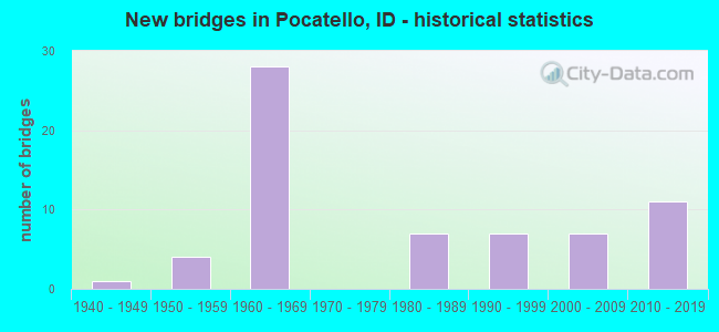
- New bridges - historical statistics
- 11940-1949
- 41950-1959
- 281960-1969
- 71980-1989
- 71990-1999
- 72000-2009
- 112010-2019


- Bridge Condition - Deck
- 19.5%Very good
- 19.5%Good
- 43.9%Satisfactory
- 12.2%Fair
- 2.4%Poor
- 2.4%Serious

- Bridge Condition - Superstructure
- 24.4%Very good
- 22.0%Good
- 31.7%Satisfactory
- 19.5%Fair
- 2.4%Serious

- Bridge Condition - Substructure
- 26.8%Very good
- 31.7%Good
- 24.4%Satisfactory
- 17.1%Fair

- Bridge Condition - Channel
- 6.3%Excellent
- 68.8%Very good
- 6.3%Good
- 18.8%Satisfactory
Find on map >> Show street view
Structure Number: P433, Location: 5KM N OF I-86 AT SR30 EXI (Lat: 42.935022, Lng: -112.544942), Route carried "on" structure: Federal lands road 152, Year Built: 1960, Status: Posted for load, Structure Length: 3.68m (12.07ft), Average Daily Traffic: 600 (year 2021), Truck Traffic: 15%, Average Future Daily Traffic: 1,200 (year 2041), Features Intersected: PORTNEUF RIVER
Minimum Vertical Clearance: 30+ m (98+ ft), Kilometerpoint: 7.200, Lanes on structure: 2, Owner: Bureau of Indian Affairs, Approaching Roadway Width: 8.4m (27.6ft), Skew: 5 degrees, Material/Design: Concrete, Design/Construction: Tee Beam, Number Of Spans In Main Unit: 4, Length of Maximum Span: 9.3m (30.5ft), Curb-To-Curb Width: 7.4m (24.3ft), Out-to-Out Width: 8.2m (26.9ft)
Condition: Deck: Fair, Superstructure: Satisfactory, Substructure: Fair, Channel: Satisfactory, Operating Rating: 9.0 metric tons, Method Used To Determine Operating Rating: Field evaluation and documented engineering judgment, Inventory Rating: 5.4 metric tons, Method Used To Determine Inventory Rating: Field evaluation and documented engineering judgment, Structural Evaluation: High priority of replacement, Deck Geometry: Meets minimum limits, Waterway Adequacy: Equal to present minimum criteria, Approach Roadway Alignment: Better than present minimum criteria, Bridge Posting: Required (Relationship of Operating Rating to Maximum Legal Load: 30.0 - 39.9% below), Length Of Structure Improvement: 4.00m (13.12ft), Designated Inspection Frequency: Every 24 months, Underwater Inspection Frequency: Every 60 months, Inspection Date: July 2021, Underwater Inspection Date: July 2019, Total Project Cost: $1,020,000 ( Estimate for 2021), Deck Structure Type: Concrete Cast-file-Place, Wearing Surface/Protective System: Wearing Surface: Monolithic Concrete
Find on map >> Show street view
Structure Number: 109, Location: 0.4 E. CHUBBUCK (Lat: 42.912583, Lng: -112.459028), Route carried "on" structure: Interstate 86, Year Built: 1963, Status: Open, Structure Length: 5.18m (16.99ft), Average Daily Traffic: 14,250 (year 2019), Truck Traffic: 12%, Average Future Daily Traffic: 21,375 (year 2039), Design Load: HS 20, Features Intersected: UPRR;CHUBBUCK OVERPASS
Minimum Vertical Clearance: 30+ m (98+ ft), Kilometerpoint: 99.198, Lanes on structure: 3, Base Highway Network: Yes, Owner: State Highway Agency, Approaching Roadway Width: 15.5m (50.9ft), Material/Design: Steel, Design/Construction: Stringer/Multi-beam, Number Of Spans In Main Unit: 3, Length of Maximum Span: 21.6m (70.9ft), Curb-To-Curb Width: 15.6m (51.2ft), Out-to-Out Width: 16.2m (53.1ft)
Condition: Deck: Satisfactory, Superstructure: Good, Substructure: Fair, Operating Rating: 67.1 metric tons, Method Used To Determine Operating Rating: Load Factor (LF), Inventory Rating: 39.9 metric tons, Method Used To Determine Inventory Rating: Load Factor (LF), Structural Evaluation: Somewhat better than minimum adequacy, Deck Geometry: Somewhat better than minimum adequacy, Underclear: Equal to present minimum criteria, Approach Roadway Alignment: Equal to present desirable criteria, Designated Inspection Frequency: Every 24 months, Other Special Inspection Frequency: Every 48 months, Inspection Date: August 2020, Other Special Inspection Date: August 2018, Deck Structure Type: Concrete Cast-file-Place, Wearing Surface/Protective System: Wearing Surface: Epoxy Overlay
Find on map >> Show street view
Structure Number: 10905, Location: 0.4 E. CHUBBUCK (Lat: 42.912894, Lng: -112.458481), Route carried "on" structure: Interstate 86, Year Built: 1963, Status: Open, Structure Length: 5.18m (16.99ft), Average Daily Traffic: 14,250 (year 2019), Truck Traffic: 12%, Average Future Daily Traffic: 21,375 (year 2039), Design Load: HS 20, Features Intersected: UPRR;CHUBBUCK OVERPASS
Minimum Vertical Clearance: 30+ m (98+ ft), Kilometerpoint: 99.200, Lanes on structure: 2, Base Highway Network: Yes, Owner: State Highway Agency, Approaching Roadway Width: 11.9m (39.0ft), Material/Design: Steel, Design/Construction: Stringer/Multi-beam, Number Of Spans In Main Unit: 3, Length of Maximum Span: 21.6m (70.9ft), Curb-To-Curb Width: 11.6m (38.1ft), Out-to-Out Width: 12.2m (40.0ft)
Condition: Deck: Satisfactory, Superstructure: Good, Substructure: Satisfactory, Operating Rating: 72.6 metric tons, Method Used To Determine Operating Rating: Load Factor (LF), Inventory Rating: 43.5 metric tons, Method Used To Determine Inventory Rating: Load Factor (LF), Structural Evaluation: Equal to present minimum criteria, Deck Geometry: Equal to present minimum criteria, Underclear: Equal to present minimum criteria, Approach Roadway Alignment: Equal to present desirable criteria, Designated Inspection Frequency: Every 48 months, Other Special Inspection Frequency: Every 48 months, Inspection Date: August 2018, Other Special Inspection Date: August 2018, Deck Structure Type: Concrete Cast-file-Place, Wearing Surface/Protective System: Wearing Surface: Epoxy Overlay
Find on map >> Show street view
Structure Number: 10911, Location: 0.8 E. CHUBBUCK (Lat: 42.912558, Lng: -112.451342), Route carried "on" structure: Interstate 86, Year Built: 2009, Status: Open, Structure Length: 3.38m (11.09ft), Average Daily Traffic: 14,250 (year 2019), Truck Traffic: 12%, Average Future Daily Traffic: 21,375 (year 2039), Design Load: HL 93, Features Intersected: HILINE ROAD GS
Minimum Vertical Clearance: 30+ m (98+ ft), Kilometerpoint: 99.831, Lanes on structure: 3, Lanes under structure: 5, Base Highway Network: Yes, Owner: State Highway Agency, Approaching Roadway Width: 18.0m (59.1ft), Skew: 1 degrees, Material/Design: Prestressed concrete, Design/Construction: Stringer/Multi-beam, Number Of Spans In Main Unit: 1, Length of Maximum Span: 32.9m (107.9ft), Curb-To-Curb Width: 18.1m (59.4ft), Out-to-Out Width: 18.9m (62.0ft)
Condition: Deck: Good, Superstructure: Satisfactory, Substructure: Very good, Operating Rating: 90.6 metric tons, Method Used To Determine Operating Rating: Load Factor (LF), Inventory Rating: 46.3 metric tons, Method Used To Determine Inventory Rating: Load Factor (LF), Structural Evaluation: Equal to present minimum criteria, Deck Geometry: Better than present minimum criteria, Underclear: High priority of corrective action, Approach Roadway Alignment: Equal to present desirable criteria, Designated Inspection Frequency: Every 48 months, Inspection Date: August 2018, Deck Structure Type: Concrete Cast-file-Place, Wearing Surface/Protective System: Wearing Surface: Epoxy Overlay, Deck Protection: Epoxy Coated Reinforcing
Find on map >> Show street view
Structure Number: 10916, Location: 0.8 E. CHUBBUCK (Lat: 42.912847, Lng: -112.450847), Route carried "on" structure: Interstate 86, Year Built: 2010, Status: Open, Structure Length: 3.38m (11.09ft), Average Daily Traffic: 14,250 (year 2019), Truck Traffic: 12%, Average Future Daily Traffic: 21,375 (year 2039), Design Load: HL 93, Features Intersected: HILINE ROAD GS
Minimum Vertical Clearance: 30+ m (98+ ft), Kilometerpoint: 99.832, Lanes on structure: 2, Lanes under structure: 5, Base Highway Network: Yes, Owner: State Highway Agency, Approaching Roadway Width: 18.0m (59.1ft), Skew: 1 degrees, Material/Design: Prestressed concrete, Design/Construction: Stringer/Multi-beam, Number Of Spans In Main Unit: 1, Length of Maximum Span: 32.9m (107.9ft), Curb-To-Curb Width: 18.1m (59.4ft), Out-to-Out Width: 18.9m (62.0ft)
Condition: Deck: Good, Superstructure: Very good, Substructure: Very good, Operating Rating: 90.6 metric tons, Method Used To Determine Operating Rating: Load Factor (LF), Inventory Rating: 46.3 metric tons, Method Used To Determine Inventory Rating: Load Factor (LF), Structural Evaluation: Equal to present desirable criteria, Deck Geometry: Superior to present desirable criteria, Underclear: High priority of corrective action, Approach Roadway Alignment: Equal to present desirable criteria, Designated Inspection Frequency: Every 48 months, Inspection Date: August 2018, Deck Structure Type: Concrete Cast-file-Place, Wearing Surface/Protective System: Wearing Surface: Epoxy Overlay, Deck Protection: Epoxy Coated Reinforcing
Find on map >> Show street view
Structure Number: 11195, Location: 4.6 W. INKOM (Lat: 42.799053, Lng: -112.340847), Route carried "on" structure: Interstate 15, Year Built: 1965, Status: Open, Structure Length: 0.85m (2.79ft), Average Daily Traffic: 9,250 (year 2019), Truck Traffic: 20%, Average Future Daily Traffic: 13,875 (year 2039), Design Load: HS 20, Features Intersected: BLACKROCK RD.GS
Minimum Vertical Clearance: 30+ m (98+ ft), Kilometerpoint: 99.303, Lanes on structure: 2, Lanes under structure: 2, Base Highway Network: Yes, Owner: State Highway Agency, Approaching Roadway Width: 11.9m (39.0ft), Skew: 3 degrees, Material/Design: Concrete, Design/Construction: Frame, Number Of Spans In Main Unit: 1, Length of Maximum Span: 8.5m (27.9ft), Curb-To-Curb Width: 12.0m (39.4ft), Out-to-Out Width: 14.0m (45.9ft)
Condition: Deck: Satisfactory, Superstructure: Satisfactory, Substructure: Good, Operating Rating: 63.5 metric tons, Method Used To Determine Operating Rating: Load Factor (LF), Inventory Rating: 38.1 metric tons, Method Used To Determine Inventory Rating: Load Factor (LF), Structural Evaluation: Equal to present minimum criteria, Deck Geometry: Equal to present minimum criteria, Underclear: High priority of corrective action, Approach Roadway Alignment: Equal to present desirable criteria, Designated Inspection Frequency: Every 48 months, Inspection Date: September 2021, Deck Structure Type: Concrete Cast-file-Place, Wearing Surface/Protective System: Wearing Surface: Bituminous
Find on map >> Show street view
Structure Number: 112, Location: 4.6 W. INKOM (Lat: 42.798681, Lng: -112.341000), Route carried "on" structure: Interstate 15, Year Built: 1965, Status: Open, Structure Length: 0.85m (2.79ft), Average Daily Traffic: 9,250 (year 2019), Truck Traffic: 20%, Average Future Daily Traffic: 13,875 (year 2039), Design Load: HS 20, Features Intersected: BLACKROCK RD.GS
Minimum Vertical Clearance: 30+ m (98+ ft), Kilometerpoint: 99.305, Lanes on structure: 2, Lanes under structure: 2, Base Highway Network: Yes, Owner: State Highway Agency, Approaching Roadway Width: 12.2m (40.0ft), Skew: 3 degrees, Material/Design: Concrete, Design/Construction: Frame, Number Of Spans In Main Unit: 1, Length of Maximum Span: 8.5m (27.9ft), Curb-To-Curb Width: 12.2m (40.0ft), Out-to-Out Width: 14.0m (45.9ft)
Condition: Deck: Satisfactory, Superstructure: Satisfactory, Substructure: Good, Operating Rating: 63.5 metric tons, Method Used To Determine Operating Rating: Load Factor (LF), Inventory Rating: 38.1 metric tons, Method Used To Determine Inventory Rating: Load Factor (LF), Structural Evaluation: Equal to present minimum criteria, Deck Geometry: Better than present minimum criteria, Underclear: High priority of corrective action, Approach Roadway Alignment: Equal to present desirable criteria, Designated Inspection Frequency: Every 48 months, Inspection Date: September 2021, Deck Structure Type: Concrete Cast-file-Place, Wearing Surface/Protective System: Wearing Surface: Bituminous
Find on map >> Show street view
Structure Number: 11205, Location: 3.6 S. POCATELLO (Lat: 42.799028, Lng: -112.363250), Route carried "on" structure: Interstate 15, Year Built: 1963, Status: Open, Structure Length: 5.03m (16.50ft), Average Daily Traffic: 9,250 (year 2019), Truck Traffic: 20%, Average Future Daily Traffic: 13,875 (year 2039), Design Load: HS 20, Features Intersected: STC 1762;PORTNEUF RD IC
Minimum Vertical Clearance: 30+ m (98+ ft), Kilometerpoint: 101.308, Lanes on structure: 2, Lanes under structure: 2, Base Highway Network: Yes, Owner: State Highway Agency, Approaching Roadway Width: 11.6m (38.1ft), Skew: 4 degrees, Material/Design: Prestressed concrete, Design/Construction: Stringer/Multi-beam, Number Of Spans In Main Unit: 3, Length of Maximum Span: 16.2m (53.1ft), Curb-To-Curb Width: 11.6m (38.1ft), Out-to-Out Width: 12.2m (40.0ft)
Condition: Deck: Satisfactory, Superstructure: Fair, Substructure: Fair, Operating Rating: 63.5 metric tons, Method Used To Determine Operating Rating: Load Factor (LF), Inventory Rating: 38.1 metric tons, Method Used To Determine Inventory Rating: Load Factor (LF), Structural Evaluation: Somewhat better than minimum adequacy, Deck Geometry: Equal to present minimum criteria, Underclear: High priority of replacement, Approach Roadway Alignment: Equal to present desirable criteria, Length Of Structure Improvement: 6.04m (19.82ft), Designated Inspection Frequency: Every 24 months, Inspection Date: September 2021, Bridge Improvement Cost: $1,372,000, Roadway Improvement Cost: $137,000, Total Project Cost: $2,058,000 ( Estimate for 2019), Deck Structure Type: Concrete Cast-file-Place, Wearing Surface/Protective System: Wearing Surface: Bituminous, Membrane: Preformed Fabric
Find on map >> Show street view
Structure Number: 1121, Location: 3.6 S. POCATELLO (Lat: 42.798861, Lng: -112.363639), Route carried "on" structure: Interstate 15, Year Built: 1963, Status: Open, Structure Length: 5.03m (16.50ft), Average Daily Traffic: 9,250 (year 2019), Truck Traffic: 20%, Average Future Daily Traffic: 13,875 (year 2039), Design Load: HS 20, Features Intersected: STC 1762;PORTNEUF RD IC
Minimum Vertical Clearance: 30+ m (98+ ft), Kilometerpoint: 101.310, Lanes on structure: 2, Lanes under structure: 2, Base Highway Network: Yes, Owner: State Highway Agency, Approaching Roadway Width: 11.6m (38.1ft), Skew: 4 degrees, Material/Design: Prestressed concrete, Design/Construction: Stringer/Multi-beam, Number Of Spans In Main Unit: 3, Length of Maximum Span: 16.2m (53.1ft), Curb-To-Curb Width: 11.6m (38.1ft), Out-to-Out Width: 12.2m (40.0ft)
Condition: Deck: Satisfactory, Superstructure: Fair, Substructure: Fair, Operating Rating: 62.6 metric tons, Method Used To Determine Operating Rating: Load Factor (LF), Inventory Rating: 37.2 metric tons, Method Used To Determine Inventory Rating: Load Factor (LF), Structural Evaluation: Somewhat better than minimum adequacy, Deck Geometry: Equal to present minimum criteria, Underclear: High priority of replacement, Approach Roadway Alignment: Equal to present desirable criteria, Length Of Structure Improvement: 6.04m (19.82ft), Designated Inspection Frequency: Every 24 months, Inspection Date: September 2021, Bridge Improvement Cost: $1,372,000, Roadway Improvement Cost: $137,000, Total Project Cost: $2,058,000 ( Estimate for 2019), Deck Structure Type: Concrete Cast-file-Place, Wearing Surface/Protective System: Wearing Surface: Bituminous, Membrane: Preformed Fabric
Find on map >> Show street view
Structure Number: 11225, Location: 2.6 S. POCATELLO (Lat: 42.839333, Lng: -112.410444), Route carried "on" structure: Interstate 15, Year Built: 1965, Status: Open, Structure Length: 8.56m (28.08ft), Average Daily Traffic: 10,000 (year 2019), Truck Traffic: 17%, Average Future Daily Traffic: 15,000 (year 2039), Design Load: HS 20, Features Intersected: I 15B;S.POCATELLO IC
Minimum Vertical Clearance: 30+ m (98+ ft), Kilometerpoint: 107.462, Lanes on structure: 2, Lanes under structure: 4, Base Highway Network: Yes, Owner: State Highway Agency, Approaching Roadway Width: 11.6m (38.1ft), Skew: 5 degrees, Material/Design: Prestressed concrete, Design/Construction: Stringer/Multi-beam, Number Of Spans In Main Unit: 4, Length of Maximum Span: 22.3m (73.2ft), Curb-To-Curb Width: 9.1m (29.9ft), Out-to-Out Width: 10.1m (33.1ft)
Condition: Deck: Very good, Superstructure: Satisfactory, Substructure: Good, Operating Rating: 64.4 metric tons, Method Used To Determine Operating Rating: Load Factor (LF), Inventory Rating: 35.4 metric tons, Method Used To Determine Inventory Rating: Load Factor (LF), Structural Evaluation: Equal to present minimum criteria, Deck Geometry: Meets minimum limits, Underclear: Meets minimum limits, Approach Roadway Alignment: Equal to present desirable criteria, Length Of Structure Improvement: 9.42m (30.91ft), Designated Inspection Frequency: Every 48 months, Inspection Date: September 2021, Bridge Improvement Cost: $2,141,000, Roadway Improvement Cost: $214,000, Total Project Cost: $3,212,000 ( Estimate for 2019), Deck Structure Type: Concrete Cast-file-Place, Wearing Surface/Protective System: Wearing Surface: Latex Concrete
Find on map >> Show street view
Structure Number: 1123, Location: 2.6 S. POCATELLO (Lat: 42.840417, Lng: -112.411222), Route carried "on" structure: Interstate 15, Year Built: 1965, Status: Open, Structure Length: 8.56m (28.08ft), Average Daily Traffic: 10,000 (year 2019), Truck Traffic: 17%, Average Future Daily Traffic: 15,000 (year 2039), Design Load: HS 20, Features Intersected: I 15B;S.POCATELLO IC
Minimum Vertical Clearance: 30+ m (98+ ft), Kilometerpoint: 107.464, Lanes on structure: 2, Lanes under structure: 4, Base Highway Network: Yes, Owner: State Highway Agency, Approaching Roadway Width: 11.6m (38.1ft), Skew: 5 degrees, Material/Design: Prestressed concrete, Design/Construction: Stringer/Multi-beam, Number Of Spans In Main Unit: 4, Length of Maximum Span: 22.3m (73.2ft), Curb-To-Curb Width: 9.1m (29.9ft), Out-to-Out Width: 10.1m (33.1ft)
Condition: Deck: Very good, Superstructure: Satisfactory, Substructure: Good, Operating Rating: 64.4 metric tons, Method Used To Determine Operating Rating: Load Factor (LF), Inventory Rating: 35.4 metric tons, Method Used To Determine Inventory Rating: Load Factor (LF), Structural Evaluation: Equal to present minimum criteria, Deck Geometry: Meets minimum limits, Underclear: Meets minimum limits, Approach Roadway Alignment: Equal to present desirable criteria, Length Of Structure Improvement: 9.42m (30.91ft), Designated Inspection Frequency: Every 48 months, Inspection Date: September 2021, Bridge Improvement Cost: $2,141,000, Roadway Improvement Cost: $214,000, Total Project Cost: $3,212,000 ( Estimate for 2019), Deck Structure Type: Concrete Cast-file-Place, Wearing Surface/Protective System: Wearing Surface: Latex Concrete
Find on map >> Show street view
Structure Number: 11235, Location: 1.7 S. POCATELLO (Lat: 42.851778, Lng: -112.415194), Route carried "on" structure: Interstate 15, Year Built: 1964, Status: Open, Structure Length: 3.35m (10.99ft), Average Daily Traffic: 11,500 (year 2019), Truck Traffic: 15%, Average Future Daily Traffic: 17,250 (year 2039), Design Load: HS 20, Features Intersected: BARTON RD.GS
Minimum Vertical Clearance: 30+ m (98+ ft), Kilometerpoint: 108.899, Lanes on structure: 2, Lanes under structure: 2, Base Highway Network: Yes, Owner: State Highway Agency, Approaching Roadway Width: 11.6m (38.1ft), Material/Design: Concrete, Design/Construction: Stringer/Multi-beam, Number Of Spans In Main Unit: 3, Length of Maximum Span: 11.3m (37.1ft), Curb-To-Curb Width: 11.4m (37.4ft), Out-to-Out Width: 12.0m (39.4ft)
Condition: Deck: Very good, Superstructure: Fair, Substructure: Satisfactory, Operating Rating: 60.8 metric tons, Method Used To Determine Operating Rating: Load Factor (LF), Inventory Rating: 36.3 metric tons, Method Used To Determine Inventory Rating: Load Factor (LF), Structural Evaluation: Somewhat better than minimum adequacy, Deck Geometry: Somewhat better than minimum adequacy, Underclear: High priority of corrective action, Approach Roadway Alignment: Equal to present desirable criteria, Designated Inspection Frequency: Every 24 months, Inspection Date: September 2021, Deck Structure Type: Concrete Cast-file-Place, Wearing Surface/Protective System: Wearing Surface: Latex Concrete
Find on map >> Show street view
Structure Number: 11245, Location: 0.6 S. POCATELLO (Lat: 42.866889, Lng: -112.421000), Route carried "on" structure: Interstate 15, Year Built: 1964, Status: Open, Structure Length: 4.63m (15.19ft), Average Daily Traffic: 11,500 (year 2019), Truck Traffic: 15%, Average Future Daily Traffic: 17,250 (year 2039), Design Load: HS 20, Features Intersected: SMA 7461;E. TERRY ST
Minimum Vertical Clearance: 30+ m (98+ ft), Kilometerpoint: 110.721, Lanes on structure: 2, Lanes under structure: 3, Base Highway Network: Yes, Owner: State Highway Agency, Approaching Roadway Width: 11.6m (38.1ft), Material/Design: Concrete, Design/Construction: Stringer/Multi-beam, Number Of Spans In Main Unit: 4, Length of Maximum Span: 11.3m (37.1ft), Curb-To-Curb Width: 11.4m (37.4ft), Out-to-Out Width: 12.0m (39.4ft)
Condition: Deck: Good, Superstructure: Fair, Substructure: Good, Operating Rating: 46.3 metric tons, Method Used To Determine Operating Rating: Load Factor (LF), Inventory Rating: 28.1 metric tons, Method Used To Determine Inventory Rating: Load Factor (LF), Structural Evaluation: Somewhat better than minimum adequacy, Deck Geometry: Somewhat better than minimum adequacy, Underclear: High priority of replacement, Approach Roadway Alignment: Equal to present desirable criteria, Length Of Structure Improvement: 5.55m (18.21ft), Designated Inspection Frequency: Every 24 months, Inspection Date: September 2021, Bridge Improvement Cost: $1,261,000, Roadway Improvement Cost: $126,000, Total Project Cost: $1,892,000 ( Estimate for 2017), Deck Structure Type: Concrete Cast-file-Place, Wearing Surface/Protective System: Wearing Surface: Latex Concrete
Find on map >> Show street view
Structure Number: 1125, Location: 0.6 S. POCATELLO (Lat: 42.867222, Lng: -112.421528), Route carried "on" structure: Interstate 15, Year Built: 1964, Status: Open, Structure Length: 4.63m (15.19ft), Average Daily Traffic: 11,500 (year 2019), Truck Traffic: 15%, Average Future Daily Traffic: 17,250 (year 2039), Design Load: HS 20, Features Intersected: SMA 7461;E. TERRY ST
Minimum Vertical Clearance: 30+ m (98+ ft), Kilometerpoint: 110.723, Lanes on structure: 2, Lanes under structure: 3, Base Highway Network: Yes, Owner: State Highway Agency, Approaching Roadway Width: 11.6m (38.1ft), Material/Design: Concrete, Design/Construction: Stringer/Multi-beam, Number Of Spans In Main Unit: 4, Length of Maximum Span: 11.3m (37.1ft), Curb-To-Curb Width: 11.4m (37.4ft), Out-to-Out Width: 12.0m (39.4ft)
Condition: Deck: Good, Superstructure: Satisfactory, Substructure: Good, Operating Rating: 46.3 metric tons, Method Used To Determine Operating Rating: Load Factor (LF), Inventory Rating: 28.1 metric tons, Method Used To Determine Inventory Rating: Load Factor (LF), Structural Evaluation: Equal to present minimum criteria, Deck Geometry: Somewhat better than minimum adequacy, Underclear: High priority of replacement, Approach Roadway Alignment: Equal to present desirable criteria, Length Of Structure Improvement: 5.55m (18.21ft), Designated Inspection Frequency: Every 24 months, Inspection Date: September 2021, Bridge Improvement Cost: $1,261,000, Roadway Improvement Cost: $126,000, Total Project Cost: $1,892,000 ( Estimate for 2019), Deck Structure Type: Concrete Cast-file-Place, Wearing Surface/Protective System: Wearing Surface: Latex Concrete
Find on map >> Show street view
Structure Number: 11256, Location: IN POCATELLO (Lat: 42.875358, Lng: -112.424822), Route carried "on" structure: Interstate 15, Year Built: 2007, Status: Open, Structure Length: 4.21m (13.81ft), Average Daily Traffic: 11,500 (year 2019), Truck Traffic: 15%, Average Future Daily Traffic: 17,250 (year 2039), Design Load: HL 93, Features Intersected: STP 7341; CENTER ST. IC.
Minimum Vertical Clearance: 30+ m (98+ ft), Kilometerpoint: 111.634, Lanes on structure: 2, Lanes under structure: 7, Base Highway Network: Yes, Owner: State Highway Agency, Approaching Roadway Width: 11.6m (38.1ft), Skew: 1 degrees, Material/Design: Prestressed concrete, Design/Construction: Box Beam or Girders - Multiple, Number Of Spans In Main Unit: 2, Length of Maximum Span: 22.6m (74.1ft), Curb-To-Curb Width: 18.1m (59.4ft), Out-to-Out Width: 18.9m (62.0ft)
Condition: Deck: Good, Superstructure: Very good, Substructure: Very good, Operating Rating: 81.6 metric tons, Method Used To Determine Operating Rating: Load Factor (LF), Inventory Rating: 34.5 metric tons, Method Used To Determine Inventory Rating: Load Factor (LF), Structural Evaluation: Equal to present desirable criteria, Deck Geometry: Superior to present desirable criteria, Underclear: High priority of corrective action, Approach Roadway Alignment: Equal to present desirable criteria, Designated Inspection Frequency: Every 48 months, Inspection Date: June 2021, Deck Structure Type: Concrete Cast-file-Place, Wearing Surface/Protective System: Wearing Surface: Epoxy Overlay, Deck Protection: Epoxy Coated Reinforcing
Find on map >> Show street view
Structure Number: 11261, Location: IN POCATELLO (Lat: 42.875681, Lng: -112.425331), Route carried "on" structure: Interstate 15, Year Built: 2007, Status: Open, Structure Length: 4.21m (13.81ft), Average Daily Traffic: 11,500 (year 2019), Truck Traffic: 15%, Average Future Daily Traffic: 17,250 (year 2039), Design Load: HL 93, Features Intersected: STP 7341; CENTER ST. IC.
Minimum Vertical Clearance: 30+ m (98+ ft), Kilometerpoint: 111.635, Lanes on structure: 2, Lanes under structure: 7, Base Highway Network: Yes, Owner: State Highway Agency, Approaching Roadway Width: 11.6m (38.1ft), Skew: 1 degrees, Material/Design: Prestressed concrete, Design/Construction: Box Beam or Girders - Multiple, Number Of Spans In Main Unit: 2, Length of Maximum Span: 22.6m (74.1ft), Curb-To-Curb Width: 18.1m (59.4ft), Out-to-Out Width: 18.9m (62.0ft)
Condition: Deck: Satisfactory, Superstructure: Very good, Substructure: Very good, Operating Rating: 82.6 metric tons, Method Used To Determine Operating Rating: Load Factor (LF), Inventory Rating: 34.5 metric tons, Method Used To Determine Inventory Rating: Load Factor (LF), Structural Evaluation: Equal to present desirable criteria, Deck Geometry: Superior to present desirable criteria, Underclear: High priority of corrective action, Approach Roadway Alignment: Equal to present desirable criteria, Designated Inspection Frequency: Every 48 months, Inspection Date: June 2021, Deck Structure Type: Concrete Cast-file-Place, Wearing Surface/Protective System: Wearing Surface: Epoxy Overlay, Deck Protection: Epoxy Coated Reinforcing
Find on map >> Show street view
Structure Number: 11271, Location: IN POCATELLO (Lat: 42.897247, Lng: -112.435228), Route carried "on" structure: Interstate 15, Year Built: 1999, Status: Open, Structure Length: 4.51m (14.80ft), Average Daily Traffic: 19,000 (year 2019), Truck Traffic: 10%, Average Future Daily Traffic: 28,500 (year 2039), Design Load: HS 25 or greater, Features Intersected: I 15B;POCATELLO CREEK IC
Minimum Vertical Clearance: 30+ m (98+ ft), Kilometerpoint: 114.226, Lanes on structure: 2, Lanes under structure: 7, Base Highway Network: Yes, Owner: State Highway Agency, Approaching Roadway Width: 11.6m (38.1ft), Skew: 1 degrees, Material/Design: Steel continuous, Design/Construction: Stringer/Multi-beam, Number Of Spans In Main Unit: 2, Length of Maximum Span: 22.3m (73.2ft), Curb-To-Curb Width: 17.7m (58.1ft), Out-to-Out Width: 18.6m (61.0ft)
Condition: Deck: Satisfactory, Superstructure: Good, Substructure: Good, Inventory Rating: 55.3 metric tons, Method Used To Determine Inventory Rating: Load Factor (LF), Structural Evaluation: Better than present minimum criteria, Deck Geometry: Superior to present desirable criteria, Underclear: High priority of corrective action, Approach Roadway Alignment: Equal to present desirable criteria, Designated Inspection Frequency: Every 48 months, Inspection Date: November 2018, Deck Structure Type: Concrete Cast-file-Place, Wearing Surface/Protective System: Wearing Surface: Epoxy Overlay, Deck Protection: Epoxy Coated Reinforcing
Find on map >> Show street view
Structure Number: 11276, Location: IN POCATELLO (Lat: 42.897608, Lng: -112.435753), Route carried "on" structure: Interstate 15, Year Built: 1998, Status: Open, Structure Length: 4.51m (14.80ft), Average Daily Traffic: 19,000 (year 2019), Truck Traffic: 10%, Average Future Daily Traffic: 28,500 (year 2039), Design Load: HS 25 or greater, Features Intersected: I 15B;POCATELLO CREEK IC
Minimum Vertical Clearance: 30+ m (98+ ft), Kilometerpoint: 114.228, Lanes on structure: 2, Lanes under structure: 7, Base Highway Network: Yes, Owner: State Highway Agency, Approaching Roadway Width: 11.6m (38.1ft), Skew: 1 degrees, Material/Design: Steel continuous, Design/Construction: Stringer/Multi-beam, Number Of Spans In Main Unit: 2, Length of Maximum Span: 22.3m (73.2ft), Curb-To-Curb Width: 17.7m (58.1ft), Out-to-Out Width: 18.6m (61.0ft)
Condition: Deck: Satisfactory, Superstructure: Good, Substructure: Good, Inventory Rating: 55.3 metric tons, Method Used To Determine Inventory Rating: Load Factor (LF), Structural Evaluation: Better than present minimum criteria, Deck Geometry: Superior to present desirable criteria, Underclear: High priority of corrective action, Approach Roadway Alignment: Equal to present desirable criteria, Designated Inspection Frequency: Every 48 months, Inspection Date: November 2018, Deck Structure Type: Concrete Cast-file-Place, Wearing Surface/Protective System: Wearing Surface: Epoxy Overlay, Deck Protection: Epoxy Coated Reinforcing
Find on map >> Show street view
Structure Number: 13696, Location: POCATELLO WCL (Lat: 42.906833, Lng: -112.512167), Route carried "on" structure: US 30, Year Built: 2000, Status: Open, Structure Length: 2.59m (8.50ft), Average Daily Traffic: 4,900 (year 2019), Truck Traffic: 17%, Average Future Daily Traffic: 7,350 (year 2039), Design Load: HS 25 or greater, Features Intersected: PORTNEUF RIVER
Minimum Vertical Clearance: 30+ m (98+ ft), Kilometerpoint: 534.058, Lanes on structure: 5, Base Highway Network: Yes (Inventory Route: US0, Subroute: 1), Owner: State Highway Agency, Approaching Roadway Width: 25.0m (82.0ft), Material/Design: Prestressed concrete, Design/Construction: Box Beam or Girders - Multiple, Number Of Spans In Main Unit: 1, Length of Maximum Span: 25.6m (84.0ft), Curb-To-Curb Width: 25.0m (82.0ft), Out-to-Out Width: 25.9m (85.0ft)
Condition: Deck: Satisfactory, Superstructure: Good, Substructure: Good, Channel: Very good, Operating Rating: 74.4 metric tons, Method Used To Determine Operating Rating: Load Factor (LF), Inventory Rating: 39.0 metric tons, Method Used To Determine Inventory Rating: Load Factor (LF), Structural Evaluation: Better than present minimum criteria, Deck Geometry: Superior to present desirable criteria, Waterway Adequacy: Equal to present desirable criteria, Approach Roadway Alignment: Equal to present desirable criteria, Designated Inspection Frequency: Every 48 months, Inspection Date: November 2020, Deck Structure Type: Concrete Cast-file-Place, Wearing Surface/Protective System: Wearing Surface: Low Slump Concrete, Deck Protection: Epoxy Coated Reinforcing
Find on map >> Show street view
Structure Number: 1749, Location: IN POCATELLO;QUINN ROAD (Lat: 42.905833, Lng: -112.457500), Route carried "on" structure: US 91, Year Built: 1986, Status: Open, Structure Length: 3.23m (10.60ft), Average Daily Traffic: 22,500 (year 2019), Truck Traffic: 2%, Average Future Daily Traffic: 33,750 (year 2039), Design Load: HS 25 or greater, Features Intersected: UPRR;QUINN ROAD OP
Minimum Vertical Clearance: 30+ m (98+ ft), Kilometerpoint: 127.397, Lanes on structure: 4, Base Highway Network: Yes (Inventory Route: US0, Subroute: 1), Owner: State Highway Agency, Approaching Roadway Width: 18.3m (60.0ft), Material/Design: Prestressed concrete, Design/Construction: Stringer/Multi-beam, Number Of Spans In Main Unit: 1, Length of Maximum Span: 31.4m (103.0ft), Curb or Sidewalk Widths: Left: 1.5m (4.9ft), Right: 1.5m (4.9ft), Curb-To-Curb Width: 18.3m (60.0ft), Out-to-Out Width: 22.1m (72.5ft)
Condition: Deck: Good, Superstructure: Good, Substructure: Good, Operating Rating: 80.7 metric tons, Method Used To Determine Operating Rating: Load Factor (LF), Inventory Rating: 42.6 metric tons, Method Used To Determine Inventory Rating: Load Factor (LF), Structural Evaluation: Better than present minimum criteria, Deck Geometry: Somewhat better than minimum adequacy, Underclear: Superior to present desirable criteria, Approach Roadway Alignment: Equal to present desirable criteria, Designated Inspection Frequency: Every 48 months, Inspection Date: September 2018, Deck Structure Type: Concrete Cast-file-Place, Wearing Surface/Protective System: Wearing Surface: Epoxy Overlay, Deck Protection: Epoxy Coated Reinforcing
Find on map >> Show street view
Structure Number: 19145, Location: 0.2 N. 5.8 W. INKOM (Lat: 42.795417, Lng: -112.363667), Route carried "on" structure: County highway 1762, Year Built: 1983, Status: Open, Structure Length: 2.62m (8.60ft), Average Daily Traffic: 1,500 (year 2019), Truck Traffic: 13%, Average Future Daily Traffic: 2,250 (year 2039), Design Load: HS 20, Features Intersected: PORTNEUF R;FT HALL MINE
Minimum Vertical Clearance: 30+ m (98+ ft), Kilometerpoint: 2.448, Lanes on structure: 2, Owner: County Highway Agency, Approaching Roadway Width: 11.0m (36.1ft), Skew: 2 degrees, Material/Design: Prestressed concrete, Design/Construction: Box Beam or Girders - Multiple, Number Of Spans In Main Unit: 1, Length of Maximum Span: 25.3m (83.0ft), Curb-To-Curb Width: 10.4m (34.1ft), Out-to-Out Width: 12.3m (40.4ft)
Condition: Deck: Good, Superstructure: Satisfactory, Substructure: Good, Channel: Very good, Operating Rating: 63.5 metric tons, Method Used To Determine Operating Rating: Load Factor (LF), Inventory Rating: 18.1 metric tons, Method Used To Determine Inventory Rating: Load Factor (LF), Structural Evaluation: Somewhat better than minimum adequacy, Deck Geometry: Equal to present minimum criteria, Waterway Adequacy: Equal to present desirable criteria, Approach Roadway Alignment: Equal to present desirable criteria, Length Of Structure Improvement: 2.74m (8.99ft), Designated Inspection Frequency: Every 24 months, Inspection Date: April 2021, Bridge Improvement Cost: $500,000, Roadway Improvement Cost: $50,000, Total Project Cost: $750,000, Deck Structure Type: Concrete Precast Panels, Wearing Surface/Protective System: Wearing Surface: Bituminous
Find on map >> Show street view
Structure Number: 21305, Location: IN POCATELLO;MAIN ARTHUR (Lat: 42.885639, Lng: -112.477083), Route carried "on" structure: City street 7151, Year Built: 1957, Status: Open, Structure Length: 2.74m (8.99ft), Average Daily Traffic: 9,200 (year 2019), Truck Traffic: 5%, Average Future Daily Traffic: 13,800 (year 2039), Design Load: HS 20, Features Intersected: PORTNEUF RIVER
Minimum Vertical Clearance: 30+ m (98+ ft), Kilometerpoint: 0.547, Lanes on structure: 4, Base Highway Network: Yes (Inventory Route: 71, Subroute: 1), Owner: City or Municipal Highway Agency, Approaching Roadway Width: 10.7m (35.1ft), Skew: 20 degrees, Material/Design: Concrete, Design/Construction: Stringer/Multi-beam, Number Of Spans In Main Unit: 3, Length of Maximum Span: 8.8m (28.9ft), Curb or Sidewalk Widths: Left: 0.2m (0.7ft), Right: 0.2m (0.7ft), Curb-To-Curb Width: 20.1m (65.9ft), Out-to-Out Width: 26.4m (86.6ft)
Condition: Deck: Satisfactory, Superstructure: Satisfactory, Substructure: Fair, Channel: Good, Operating Rating: 50.8 metric tons, Method Used To Determine Operating Rating: Load Factor (LF), Inventory Rating: 29.9 metric tons, Method Used To Determine Inventory Rating: Load Factor (LF), Structural Evaluation: Somewhat better than minimum adequacy, Deck Geometry: Better than present minimum criteria, Waterway Adequacy: Equal to present desirable criteria, Approach Roadway Alignment: Equal to present desirable criteria, Designated Inspection Frequency: Every 24 months, Inspection Date: October 2020, Deck Structure Type: Concrete Cast-file-Place, Wearing Surface/Protective System: Wearing Surface: Bituminous
Find on map >> Show street view
Structure Number: 2131, Location: IN POCATELLO;MAIN ARTHUR (Lat: 42.881417, Lng: -112.473556), Route carried "on" structure: City street 7151, Year Built: 1957, Status: Open, Structure Length: 2.74m (8.99ft), Average Daily Traffic: 9,200 (year 2019), Truck Traffic: 5%, Average Future Daily Traffic: 13,800 (year 2039), Design Load: HS 20, Features Intersected: PORTNEUF RIVER
Minimum Vertical Clearance: 30+ m (98+ ft), Kilometerpoint: 1.156, Lanes on structure: 4, Base Highway Network: Yes (Inventory Route: 71, Subroute: 1), Owner: City or Municipal Highway Agency, Approaching Roadway Width: 10.7m (35.1ft), Skew: 20 degrees, Material/Design: Concrete, Design/Construction: Stringer/Multi-beam, Number Of Spans In Main Unit: 3, Length of Maximum Span: 8.8m (28.9ft), Curb or Sidewalk Widths: Left: 0.2m (0.7ft), Right: 0.2m (0.7ft), Curb-To-Curb Width: 20.1m (65.9ft), Out-to-Out Width: 26.4m (86.6ft)
Condition: Deck: Satisfactory, Superstructure: Good, Substructure: Fair, Channel: Satisfactory, Operating Rating: 52.6 metric tons, Method Used To Determine Operating Rating: Load Factor (LF), Inventory Rating: 30.8 metric tons, Method Used To Determine Inventory Rating: Load Factor (LF), Structural Evaluation: Somewhat better than minimum adequacy, Deck Geometry: Better than present minimum criteria, Waterway Adequacy: Better than present minimum criteria, Approach Roadway Alignment: Equal to present desirable criteria, Designated Inspection Frequency: Every 24 months, Inspection Date: October 2020, Deck Structure Type: Concrete Cast-file-Place, Wearing Surface/Protective System: Wearing Surface: Bituminous
Find on map >> Show street view
Structure Number: 21315, Location: IN POCATELLO;BENTON ST. (Lat: 42.859556, Lng: -112.446472), Route carried "on" structure: City street 7151, Year Built: 1967, Year Reconstructed: 2019, Status: Open, Structure Length: 27.25m (89.40ft), Average Daily Traffic: 10,500 (year 2019), Truck Traffic: 2%, Average Future Daily Traffic: 15,750 (year 2039), Design Load: HS 20, Features Intersected: S.1ST AVE;UPRR;BENTON OP
Minimum Vertical Clearance: 30+ m (98+ ft), Kilometerpoint: 4.632, Lanes on structure: 4, Lanes under structure: 2, Base Highway Network: Yes (Inventory Route: 71, Subroute: 1), Owner: City or Municipal Highway Agency, Approaching Roadway Width: 17.1m (56.1ft), Material/Design: Steel, Design/Construction: Stringer/Multi-beam, Number Of Spans In Main Unit: 13, Length of Maximum Span: 35.4m (116.1ft), Curb or Sidewalk Widths: Left: 1.5m (4.9ft), Right: 1.5m (4.9ft), Curb-To-Curb Width: 17.1m (56.1ft), Out-to-Out Width: 20.8m (68.2ft)
Condition: Deck: Fair, Superstructure: Fair, Substructure: Fair, Operating Rating: 47.2 metric tons, Method Used To Determine Operating Rating: Load Factor (LF), Inventory Rating: 28.1 metric tons, Method Used To Determine Inventory Rating: Load Factor (LF), Structural Evaluation: Somewhat better than minimum adequacy, Deck Geometry: Somewhat better than minimum adequacy, Underclear: Meets minimum limits, Approach Roadway Alignment: Better than present minimum criteria, Length Of Structure Improvement: 27.43m (89.99ft), Designated Inspection Frequency: Every 24 months, Inspection Date: April 2021, Bridge Improvement Cost: $9,207,000, Roadway Improvement Cost: $921,000, Total Project Cost: $13,811,000 ( Estimate for 2020), Deck Structure Type: Concrete Cast-file-Place, Wearing Surface/Protective System: Wearing Surface: Latex Concrete
Find on map >> Show street view
Structure Number: 2135, Location: IN POCATELLO;GOULD ST (Lat: 42.873333, Lng: -112.462056), Route carried "on" structure: City street 7181, Year Built: 1982, Status: Open, Structure Length: 2.13m (6.99ft), Average Daily Traffic: 11,500 (year 2019), Average Future Daily Traffic: 17,250 (year 2039), Design Load: HS 20, Features Intersected: HARRISON AVE;GOULD ST OP
Minimum Vertical Clearance: 30+ m (98+ ft), Kilometerpoint: 0.209, Lanes on structure: 4, Lanes under structure: 2, Base Highway Network: Yes (Inventory Route: 71, Subroute: 1), Owner: City or Municipal Highway Agency, Approaching Roadway Width: 16.5m (54.1ft), Skew: 20 degrees, Material/Design: Prestressed concrete, Design/Construction: Box Beam or Girders - Multiple, Number Of Spans In Main Unit: 1, Length of Maximum Span: 20.7m (67.9ft), Curb or Sidewalk Widths: Left: 1.5m (4.9ft), Right: 2.4m (7.9ft), Curb-To-Curb Width: 16.5m (54.1ft), Out-to-Out Width: 21.8m (71.5ft)
Condition: Deck: Satisfactory, Superstructure: Fair, Substructure: Satisfactory, Operating Rating: 90.6 metric tons, Method Used To Determine Operating Rating: Load Factor (LF), Inventory Rating: 43.5 metric tons, Method Used To Determine Inventory Rating: Load Factor (LF), Structural Evaluation: Somewhat better than minimum adequacy, Deck Geometry: Meets minimum limits, Underclear: Equal to present minimum criteria, Approach Roadway Alignment: Equal to present desirable criteria, Length Of Structure Improvement: 2.13m (6.99ft), Designated Inspection Frequency: Every 24 months, Inspection Date: April 2020, Bridge Improvement Cost: $716,000, Roadway Improvement Cost: $72,000, Total Project Cost: $1,074,000 ( Estimate for 2020), Deck Structure Type: Concrete Cast-file-Place, Wearing Surface/Protective System: Wearing Surface: Bituminous
Find on map >> Show street view
Structure Number: 21355, Location: IN POCATELLO;GOULD ST (Lat: 42.873694, Lng: -112.461500), Route carried "on" structure: City street 7181, Year Built: 1982, Status: Open, Structure Length: 8.08m (26.51ft), Average Daily Traffic: 11,500 (year 2019), Average Future Daily Traffic: 17,250 (year 2039), Design Load: HS 20, Features Intersected: UPRR;GOULD ST OP
Minimum Vertical Clearance: 30+ m (98+ ft), Kilometerpoint: 0.229, Lanes on structure: 4, Base Highway Network: Yes (Inventory Route: 71, Subroute: 1), Owner: City or Municipal Highway Agency, Approaching Roadway Width: 16.5m (54.1ft), Skew: 20 degrees, Material/Design: Prestressed concrete, Design/Construction: Box Beam or Girders - Multiple, Number Of Spans In Main Unit: 4, Length of Maximum Span: 21.0m (68.9ft), Curb or Sidewalk Widths: Left: 1.5m (4.9ft), Right: 2.4m (7.9ft), Curb-To-Curb Width: 16.5m (54.1ft), Out-to-Out Width: 21.8m (71.5ft)
Condition: Deck: Satisfactory, Superstructure: Good, Substructure: Satisfactory, Operating Rating: 90.6 metric tons, Method Used To Determine Operating Rating: Load Factor (LF), Inventory Rating: 35.4 metric tons, Method Used To Determine Inventory Rating: Load Factor (LF), Structural Evaluation: Equal to present minimum criteria, Deck Geometry: Meets minimum limits, Underclear: Meets minimum limits, Approach Roadway Alignment: Equal to present desirable criteria, Length Of Structure Improvement: 8.08m (26.51ft), Designated Inspection Frequency: Every 48 months, Inspection Date: April 2020, Bridge Improvement Cost: $2,711,000, Roadway Improvement Cost: $271,000, Total Project Cost: $4,066,000 ( Estimate for 2020), Deck Structure Type: Concrete Cast-file-Place, Wearing Surface/Protective System: Wearing Surface: Bituminous
Find on map >> Show street view
Structure Number: 2136, Location: IN POCATELLO;GOULD ST (Lat: 42.874583, Lng: -112.460083), Route carried "on" structure: City street 7181, Year Built: 1982, Status: Open, Structure Length: 2.13m (6.99ft), Average Daily Traffic: 11,500 (year 2019), Average Future Daily Traffic: 17,250 (year 2039), Design Load: HS 20, Features Intersected: FIRST AVE;GOULD ST OP
Minimum Vertical Clearance: 30+ m (98+ ft), Kilometerpoint: 0.420, Lanes on structure: 4, Lanes under structure: 2, Base Highway Network: Yes (Inventory Route: 71, Subroute: 1), Owner: City or Municipal Highway Agency, Approaching Roadway Width: 16.5m (54.1ft), Skew: 20 degrees, Material/Design: Prestressed concrete, Design/Construction: Box Beam or Girders - Multiple, Number Of Spans In Main Unit: 1, Length of Maximum Span: 20.7m (67.9ft), Curb or Sidewalk Widths: Left: 1.5m (4.9ft), Right: 2.4m (7.9ft), Curb-To-Curb Width: 16.5m (54.1ft), Out-to-Out Width: 21.8m (71.5ft)
Condition: Deck: Satisfactory, Superstructure: Satisfactory, Substructure: Satisfactory, Operating Rating: 90.6 metric tons, Method Used To Determine Operating Rating: Load Factor (LF), Inventory Rating: 43.5 metric tons, Method Used To Determine Inventory Rating: Load Factor (LF), Structural Evaluation: Equal to present minimum criteria, Deck Geometry: Meets minimum limits, Underclear: Equal to present minimum criteria, Approach Roadway Alignment: Equal to present desirable criteria, Length Of Structure Improvement: 2.13m (6.99ft), Designated Inspection Frequency: Every 48 months, Inspection Date: April 2020, Bridge Improvement Cost: $716,000, Roadway Improvement Cost: $72,000, Total Project Cost: $1,074,000 ( Estimate for 2020), Deck Structure Type: Concrete Precast Panels, Wearing Surface/Protective System: Wearing Surface: Bituminous
Find on map >> Show street view
Structure Number: 21375, Location: IN POCATELLO;CARSON ST. (Lat: 42.868361, Lng: -112.465889), Route carried "on" structure: City street 7221, Year Built: 1950, Status: Posted for load, Structure Length: 1.55m (5.09ft), Average Daily Traffic: 3,900 (year 2019), Truck Traffic: 4%, Average Future Daily Traffic: 5,850 (year 2039), Design Load: H 15, Features Intersected: PORTNEUF RIVER
Minimum Vertical Clearance: 30+ m (98+ ft), Kilometerpoint: 0.023, Lanes on structure: 2, Owner: City or Municipal Highway Agency, Approaching Roadway Width: 12.2m (40.0ft), Material/Design: Steel, Design/Construction: Stringer/Multi-beam, Number Of Spans In Main Unit: 1, Length of Maximum Span: 15.2m (49.9ft), Curb or Sidewalk Widths: Left: 1.5m (4.9ft), Right: 1.5m (4.9ft), Curb-To-Curb Width: 12.2m (40.0ft), Out-to-Out Width: 16.5m (54.1ft)
Condition: Deck: Poor, Superstructure: Serious, Substructure: Satisfactory, Channel: Very good, Operating Rating: 29.9 metric tons, Method Used To Determine Operating Rating: Load Factor (LF), Inventory Rating: 18.1 metric tons, Method Used To Determine Inventory Rating: Load Factor (LF), Structural Evaluation: High priority of corrective action, Deck Geometry: Equal to present minimum criteria, Waterway Adequacy: Equal to present desirable criteria, Approach Roadway Alignment: Equal to present desirable criteria, Length Of Structure Improvement: 2.26m (7.41ft), Designated Inspection Frequency: Every 12 months, Inspection Date: April 2021, Bridge Improvement Cost: $700,000, Roadway Improvement Cost: $70,000, Total Project Cost: $1,050,000, Deck Structure Type: Concrete Cast-file-Place, Wearing Surface/Protective System: Wearing Surface: Bituminous
Find on map >> Show street view
Structure Number: 21405, Location: IN POCATELLO;CUSTER ST. (Lat: 42.865472, Lng: -112.463917), Route carried "on" structure: City street 7261, Year Built: 1953, Year Reconstructed: 2010, Status: Open, Structure Length: 1.71m (5.61ft), Average Daily Traffic: 4,900 (year 2019), Truck Traffic: 5%, Average Future Daily Traffic: 7,350 (year 2039), Design Load: H 15, Features Intersected: PORTNEUF RIVER
Minimum Vertical Clearance: 30+ m (98+ ft), Kilometerpoint: 0.901, Lanes on structure: 2, Owner: City or Municipal Highway Agency, Approaching Roadway Width: 12.2m (40.0ft), Skew: 2 degrees, Material/Design: Steel, Design/Construction: Stringer/Multi-beam, Number Of Spans In Main Unit: 1, Length of Maximum Span: 16.2m (53.1ft), Curb or Sidewalk Widths: Left: 1.6m (5.2ft), Right: 1.6m (5.2ft), Curb-To-Curb Width: 12.2m (40.0ft), Out-to-Out Width: 16.5m (54.1ft)
Condition: Deck: Satisfactory, Superstructure: Satisfactory, Substructure: Satisfactory, Channel: Very good, Operating Rating: 49.9 metric tons, Method Used To Determine Operating Rating: Load Factor (LF), Inventory Rating: 29.9 metric tons, Method Used To Determine Inventory Rating: Load Factor (LF), Structural Evaluation: Equal to present minimum criteria, Deck Geometry: Equal to present minimum criteria, Waterway Adequacy: Equal to present desirable criteria, Approach Roadway Alignment: Equal to present desirable criteria, Length Of Structure Improvement: 2.19m (7.19ft), Designated Inspection Frequency: Every 48 months, Inspection Date: September 2018, Bridge Improvement Cost: $700,000, Roadway Improvement Cost: $70,000, Total Project Cost: $1,050,000, Deck Structure Type: Concrete Cast-file-Place, Wearing Surface/Protective System: Wearing Surface: Monolithic Concrete, Deck Protection: Epoxy Coated Reinforcing
Find on map >> Show street view
Structure Number: 2143, Location: IN POCATELLO;FREMONT ST. (Lat: 42.861444, Lng: -112.457917), Route carried "on" structure: City street 7301, Year Built: 1968, Status: Open, Structure Length: 1.37m (4.49ft), Average Daily Traffic: 2,400 (year 2019), Truck Traffic: 4%, Average Future Daily Traffic: 3,600 (year 2039), Design Load: H 15, Features Intersected: PORTNEUF RIVER
Minimum Vertical Clearance: 30+ m (98+ ft), Kilometerpoint: 0.462, Lanes on structure: 2, Owner: City or Municipal Highway Agency, Approaching Roadway Width: 12.2m (40.0ft), Material/Design: Steel, Design/Construction: Stringer/Multi-beam, Number Of Spans In Main Unit: 1, Length of Maximum Span: 12.5m (41.0ft), Curb or Sidewalk Widths: Left: 1.5m (4.9ft), Right: 1.5m (4.9ft), Curb-To-Curb Width: 12.2m (40.0ft), Out-to-Out Width: 16.5m (54.1ft)
Condition: Deck: Fair, Superstructure: Satisfactory, Substructure: Good, Channel: Very good, Operating Rating: 45.4 metric tons, Method Used To Determine Operating Rating: Load Factor (LF), Inventory Rating: 27.2 metric tons, Method Used To Determine Inventory Rating: Load Factor (LF), Structural Evaluation: Equal to present minimum criteria, Deck Geometry: Equal to present minimum criteria, Waterway Adequacy: Equal to present desirable criteria, Approach Roadway Alignment: Equal to present desirable criteria, Designated Inspection Frequency: Every 24 months, Inspection Date: April 2021, Deck Structure Type: Concrete Cast-file-Place, Wearing Surface/Protective System: Wearing Surface: Bituminous
Find on map >> Show street view
Structure Number: 21515, Location: 2.0 S. POCATELLO (Lat: 42.842528, Lng: -112.428694), Route carried "on" structure: County highway 7391, Year Built: 1967, Status: Open, Structure Length: 3.57m (11.71ft), Average Daily Traffic: 7,700 (year 2019), Truck Traffic: 5%, Average Future Daily Traffic: 11,550 (year 2039), Design Load: H 20, Features Intersected: PORTNEUF RIVER
Minimum Vertical Clearance: 30+ m (98+ ft), Kilometerpoint: 88.414, Lanes on structure: 2, Base Highway Network: Yes (Inventory Route: 73, Subroute: 1), Owner: City or Municipal Highway Agency, Approaching Roadway Width: 10.4m (34.1ft), Skew: 1 degrees, Material/Design: Prestressed concrete, Design/Construction: Tee Beam, Number Of Spans In Main Unit: 3, Length of Maximum Span: 12.2m (40.0ft), Curb or Sidewalk Widths: Left: 1.2m (3.9ft), Right: 0.0m, Curb-To-Curb Width: 12.2m (40.0ft), Out-to-Out Width: 14.2m (46.6ft)
Condition: Deck: Fair, Superstructure: Fair, Substructure: Satisfactory, Channel: Very good, Operating Rating: 43.5 metric tons, Method Used To Determine Operating Rating: Load Factor (LF), Inventory Rating: 22.7 metric tons, Method Used To Determine Inventory Rating: Load Factor (LF), Structural Evaluation: Somewhat better than minimum adequacy, Deck Geometry: Somewhat better than minimum adequacy, Waterway Adequacy: Equal to present desirable criteria, Approach Roadway Alignment: Equal to present minimum criteria, Length Of Structure Improvement: 4.57m (14.99ft), Designated Inspection Frequency: Every 24 months, Underwater Inspection Frequency: Every 60 months, Inspection Date: April 2021, Underwater Inspection Date: October 2021, Bridge Improvement Cost: $1,500,000, Roadway Improvement Cost: $150,000, Total Project Cost: $2,250,000, Deck Structure Type: Concrete Cast-file-Place, Wearing Surface/Protective System: Wearing Surface: Bituminous
Find on map >> Show street view
Structure Number: 2194, Location: 0.2 N. 4.0 W. INKOM (Lat: 42.795194, Lng: -112.329417), Route carried "on" structure: County highway , Year Built: 1948, Status: Open, Structure Length: 1.28m (4.20ft), Average Daily Traffic: 100 (year 2019), Truck Traffic: 10%, Average Future Daily Traffic: 150 (year 2039), Design Load: HS 20, Features Intersected: PORTNEUF R;NW.INKOM BR, Facility Carried by Structure: W BLACKROCK ROAD
Minimum Vertical Clearance: 30+ m (98+ ft), Kilometerpoint: 161.197, Lanes on structure: 2, Owner: County Highway Agency, Approaching Roadway Width: 7.9m (25.9ft), Skew: 1 degrees, Material/Design: Steel, Design/Construction: Culvert, Number Of Spans In Main Unit: 2, Length of Maximum Span: 6.1m (20.0ft), Curb-To-Curb Width: 7.5m (24.6ft), Out-to-Out Width: 9.4m (30.8ft)
Condition: Channel: Satisfactory, Culverts: Satisfactory, Operating Rating: 49.5 metric tons, Method Used To Determine Operating Rating: Allowable Stress (AS), Inventory Rating: 32.4 metric tons, Method Used To Determine Inventory Rating: Allowable Stress (AS), Structural Evaluation: Equal to present minimum criteria, Deck Geometry: Equal to present minimum criteria, Waterway Adequacy: Better than present minimum criteria, Approach Roadway Alignment: Equal to present desirable criteria, Designated Inspection Frequency: Every 48 months, Inspection Date: September 2020
Find on map >> Show street view
Structure Number: 22151, Location: IN POCATELLO (Lat: 42.891861, Lng: -112.433472), Route carried "on" structure: City street , Year Built: 1997, Status: Open, Structure Length: 9.02m (29.59ft), Average Daily Traffic: 2,300 (year 2019), Average Future Daily Traffic: 3,450 (year 2039), Design Load: HS 25 or greater, Features Intersected: I 15;MONTE VISTA AVE GS, Facility Carried by Structure: MONTE VISTA AVENUE
Minimum Vertical Clearance: 30+ m (98+ ft), Kilometerpoint: 161.977, Lanes on structure: 2, Lanes under structure: 6, Owner: State Highway Agency, Approaching Roadway Width: 14.6m (47.9ft), Skew: 1 degrees, Material/Design: Steel continuous, Design/Construction: Stringer/Multi-beam, Number Of Spans In Main Unit: 4, Length of Maximum Span: 30.5m (100.1ft), Curb or Sidewalk Widths: Left: 1.7m (5.6ft), Right: 1.7m (5.6ft), Curb-To-Curb Width: 10.2m (33.5ft), Out-to-Out Width: 14.0m (45.9ft)
Condition: Deck: Satisfactory, Superstructure: Good, Substructure: Good, Operating Rating: 49.9 metric tons, Method Used To Determine Operating Rating: Load Factor (LF), Inventory Rating: 29.9 metric tons, Method Used To Determine Inventory Rating: Load Factor (LF), Structural Evaluation: Better than present minimum criteria, Deck Geometry: Meets minimum limits, Underclear: High priority of corrective action, Approach Roadway Alignment: Equal to present desirable criteria, Designated Inspection Frequency: Every 48 months, Inspection Date: November 2018, Deck Structure Type: Concrete Cast-file-Place, Wearing Surface/Protective System: Wearing Surface: Low Slump Concrete, Deck Protection: Epoxy Coated Reinforcing
Find on map >> Show street view
Structure Number: 22175, Location: IN POCATELLO;BENTON ST (Lat: 42.857028, Lng: -112.450417), Route carried "on" structure: City street 7151, Year Built: 1969, Status: Open, Structure Length: 1.43m (4.69ft), Average Daily Traffic: 3,300 (year 2019), Truck Traffic: 4%, Average Future Daily Traffic: 4,950 (year 2039), Design Load: H 15, Features Intersected: PORTNEUF RIVER
Minimum Vertical Clearance: 30+ m (98+ ft), Kilometerpoint: 16.174, Lanes on structure: 2, Owner: City or Municipal Highway Agency, Approaching Roadway Width: 12.2m (40.0ft), Skew: 2 degrees, Material/Design: Steel, Design/Construction: Stringer/Multi-beam, Number Of Spans In Main Unit: 1, Length of Maximum Span: 13.7m (44.9ft), Curb or Sidewalk Widths: Left: 1.4m (4.6ft), Right: 1.4m (4.6ft), Curb-To-Curb Width: 12.2m (40.0ft), Out-to-Out Width: 16.4m (53.8ft)
Condition: Deck: Serious, Superstructure: Fair, Substructure: Satisfactory, Channel: Very good, Operating Rating: 41.7 metric tons, Method Used To Determine Operating Rating: Load Factor (LF), Inventory Rating: 25.4 metric tons, Method Used To Determine Inventory Rating: Load Factor (LF), Structural Evaluation: Somewhat better than minimum adequacy, Deck Geometry: Equal to present minimum criteria, Waterway Adequacy: Equal to present desirable criteria, Approach Roadway Alignment: Equal to present desirable criteria, Length Of Structure Improvement: 1.95m (6.40ft), Designated Inspection Frequency: Every 12 months, Inspection Date: April 2021, Bridge Improvement Cost: $612,000, Roadway Improvement Cost: $61,000, Total Project Cost: $919,000, Deck Structure Type: Concrete Cast-file-Place, Wearing Surface/Protective System: Wearing Surface: Bituminous
Find on map >> Show street view
Structure Number: 2218, Location: IN POCATELLO;CENTER ST (Lat: 42.859361, Lng: -112.455000), Route carried "on" structure: City street , Year Built: 1968, Status: Open, Structure Length: 1.40m (4.59ft), Average Daily Traffic: 2,850 (year 2019), Truck Traffic: 10%, Average Future Daily Traffic: 4,275 (year 2039), Design Load: H 15, Features Intersected: PORTNEUF RIVER, Facility Carried by Structure: CENTER STREET
Minimum Vertical Clearance: 30+ m (98+ ft), Kilometerpoint: 480.715, Lanes on structure: 2, Owner: City or Municipal Highway Agency, Approaching Roadway Width: 12.2m (40.0ft), Skew: 1 degrees, Material/Design: Steel, Design/Construction: Stringer/Multi-beam, Number Of Spans In Main Unit: 1, Length of Maximum Span: 13.1m (43.0ft), Curb or Sidewalk Widths: Left: 1.5m (4.9ft), Right: 1.5m (4.9ft), Curb-To-Curb Width: 12.2m (40.0ft), Out-to-Out Width: 16.4m (53.8ft)
Condition: Deck: Fair, Superstructure: Satisfactory, Substructure: Satisfactory, Channel: Very good, Operating Rating: 42.6 metric tons, Method Used To Determine Operating Rating: Load Factor (LF), Inventory Rating: 25.4 metric tons, Method Used To Determine Inventory Rating: Load Factor (LF), Structural Evaluation: Equal to present minimum criteria, Deck Geometry: Equal to present minimum criteria, Waterway Adequacy: Equal to present desirable criteria, Approach Roadway Alignment: Equal to present desirable criteria, Designated Inspection Frequency: Every 24 months, Inspection Date: April 2021, Deck Structure Type: Concrete Cast-file-Place, Wearing Surface/Protective System: Wearing Surface: Bituminous
Find on map >> Show street view
Structure Number: 22186, Location: IN POCATELLO; LEWIS ST (Lat: 42.858750, Lng: -112.453917), Route carried "on" structure: City street , Year Built: 2017, Status: Open, Structure Length: 2.35m (7.71ft), Average Daily Traffic: 2,500 (year 2019), Truck Traffic: 10%, Average Future Daily Traffic: 3,750 (year 2039), Design Load: HL 93, Features Intersected: PORTNEUF RIVER, Facility Carried by Structure: LEWIS STREET
Minimum Vertical Clearance: 30+ m (98+ ft), Kilometerpoint: 16.346, Lanes on structure: 2, Owner: City or Municipal Highway Agency, Approaching Roadway Width: 9.1m (29.9ft), Material/Design: Prestressed concrete, Design/Construction: Stringer/Multi-beam, Number Of Spans In Main Unit: 1, Length of Maximum Span: 22.6m (74.1ft), Curb or Sidewalk Widths: Left: 1.5m (4.9ft), Right: 1.5m (4.9ft), Curb-To-Curb Width: 8.5m (27.9ft), Out-to-Out Width: 12.0m (39.4ft)
Condition: Deck: Good, Superstructure: Very good, Substructure: Very good, Channel: Very good, Operating Rating: 64.5 metric tons, Method Used To Determine Operating Rating: Load and Resistance Factor Rating (LRFR) rating reported by rating factor(RF) method using HL-93 loadings, Inventory Rating: 44.1 metric tons, Method Used To Determine Inventory Rating: Load and Resistance Factor Rating (LRFR) rating reported by rating factor(RF) method using HL-93 loadings, Structural Evaluation: Equal to present desirable criteria, Deck Geometry: Meets minimum limits, Waterway Adequacy: Equal to present desirable criteria, Approach Roadway Alignment: Equal to present desirable criteria, Designated Inspection Frequency: Every 48 months, Inspection Date: April 2019, Deck Structure Type: Concrete Cast-file-Place, Wearing Surface/Protective System: Deck Protection: Epoxy Coated Reinforcing
Find on map >> Show street view
Structure Number: 22196, Location: IN POCATELLO; CLARK ST. (Lat: 42.859917, Lng: -112.456167), Route carried "on" structure: City street , Year Built: 1998, Status: Open, Structure Length: 1.62m (5.31ft), Average Daily Traffic: 400 (year 2019), Truck Traffic: 10%, Average Future Daily Traffic: 600 (year 2039), Design Load: HS 20, Features Intersected: PORTNEUF RIVER, Facility Carried by Structure: CLARK STREET
Minimum Vertical Clearance: 30+ m (98+ ft), Kilometerpoint: 161.224, Lanes on structure: 2, Owner: City or Municipal Highway Agency, Approaching Roadway Width: 12.2m (40.0ft), Skew: 1 degrees, Material/Design: Prestressed concrete, Design/Construction: Stringer/Multi-beam, Number Of Spans In Main Unit: 1, Length of Maximum Span: 15.5m (50.9ft), Curb or Sidewalk Widths: Left: 1.8m (5.9ft), Right: 1.8m (5.9ft), Curb-To-Curb Width: 12.2m (40.0ft), Out-to-Out Width: 16.3m (53.5ft)
Condition: Deck: Satisfactory, Superstructure: Very good, Substructure: Very good, Channel: Very good, Operating Rating: 73.5 metric tons, Method Used To Determine Operating Rating: Load Factor (LF), Inventory Rating: 39.9 metric tons, Method Used To Determine Inventory Rating: Load Factor (LF), Structural Evaluation: Equal to present desirable criteria, Deck Geometry: Superior to present desirable criteria, Waterway Adequacy: Superior to present desirable criteria, Approach Roadway Alignment: Equal to present desirable criteria, Designated Inspection Frequency: Every 48 months, Inspection Date: September 2018, Deck Structure Type: Concrete Cast-file-Place, Wearing Surface/Protective System: Wearing Surface: Monolithic Concrete, Deck Protection: Epoxy Coated Reinforcing
Find on map >> Show street view
Structure Number: 3452, Location: 1.0 W. OF I-15 IC (Lat: 42.829200, Lng: -112.412200), Route carried "on" structure: City street 7217, Year Built: 2016, Status: Open, Structure Length: 12.89m (42.29ft), Average Daily Traffic: 5,200 (year 2019), Truck Traffic: 3%, Average Future Daily Traffic: 7,800 (year 2039), Design Load: HL 93, Features Intersected: S 2ND;PORTNEUF R;UPRR
Minimum Vertical Clearance: 30+ m (98+ ft), Kilometerpoint: 161.475, Lanes on structure: 2, Lanes under structure: 2, Owner: City or Municipal Highway Agency, Approaching Roadway Width: 13.2m (43.3ft), Material/Design: Steel continuous, Design/Construction: Stringer/Multi-beam, Number Of Spans In Main Unit: 2, Length of Maximum Span: 69.2m (227.0ft), Curb or Sidewalk Widths: Left: 0.0m, Right: 4.6m (15.1ft), Curb-To-Curb Width: 13.2m (43.3ft), Out-to-Out Width: 18.5m (60.7ft)
Condition: Deck: Very good, Superstructure: Very good, Substructure: Very good, Channel: Very good, Operating Rating: 47.0 metric tons, Method Used To Determine Operating Rating: Load and Resistance Factor Rating (LRFR) rating reported by rating factor(RF) method using HL-93 loadings, Inventory Rating: 36.3 metric tons, Method Used To Determine Inventory Rating: Load and Resistance Factor Rating (LRFR) rating reported by rating factor(RF) method using HL-93 loadings, Structural Evaluation: Equal to present desirable criteria, Deck Geometry: Somewhat better than minimum adequacy, Underclear: Equal to present minimum criteria, Waterway Adequacy: Superior to present desirable criteria, Approach Roadway Alignment: Superior to present desirable criteria, Designated Inspection Frequency: Every 48 months, Inspection Date: April 2018, Deck Structure Type: Concrete Cast-file-Place, Wearing Surface/Protective System: Wearing Surface: Integral Concrete, Deck Protection: Epoxy Coated Reinforcing
Find on map >> Show street view
Structure Number: 34525, Location: 0.3 W. of I15 IC (Lat: 42.830639, Lng: -112.409028), Route carried "on" structure: City street 7217, Year Built: 2016, Status: Open, Structure Length: 0.64m (2.10ft), Average Daily Traffic: 5,200 (year 2019), Truck Traffic: 3%, Average Future Daily Traffic: 7,800 (year 2039), Design Load: HL 93, Features Intersected: AMI TRAIL
Minimum Vertical Clearance: 30+ m (98+ ft), Kilometerpoint: 161.869, Lanes on structure: 3, Owner: City or Municipal Highway Agency, Approaching Roadway Width: 16.5m (54.1ft), Skew: 4 degrees, Material/Design: Concrete, Design/Construction: Frame, Number Of Spans In Main Unit: 1, Length of Maximum Span: 6.4m (21.0ft), Curb-To-Curb Width: 16.5m (54.1ft), Out-to-Out Width: 32.3m (106.0ft)
Condition: Deck: Very good, Superstructure: Very good, Substructure: Very good, Operating Rating: 71.3 metric tons, Method Used To Determine Operating Rating: Load and Resistance Factor Rating (LRFR) rating reported by rating factor(RF) method using HL-93 loadings, Inventory Rating: 55.1 metric tons, Method Used To Determine Inventory Rating: Load and Resistance Factor Rating (LRFR) rating reported by rating factor(RF) method using HL-93 loadings, Structural Evaluation: Equal to present desirable criteria, Deck Geometry: Better than present minimum criteria, Approach Roadway Alignment: Equal to present desirable criteria, Designated Inspection Frequency: Every 48 months, Inspection Date: April 2018
Find on map >> Show street view
Structure Number: 3454, Location: 3.35 SE POCATELLO (Lat: 42.830531, Lng: -112.405758), Route carried "on" structure: Interstate 15, Year Built: 2015, Status: Open, Structure Length: 5.61m (18.41ft), Average Daily Traffic: 10,000 (year 2019), Truck Traffic: 17%, Average Future Daily Traffic: 15,000 (year 2039), Design Load: HL 93, Features Intersected: SMA 5697;SOUTH VALLEY RD
Minimum Vertical Clearance: 30+ m (98+ ft), Kilometerpoint: 106.498, Lanes on structure: 2, Lanes under structure: 2, Base Highway Network: Yes, Owner: State Highway Agency, Approaching Roadway Width: 13.1m (43.0ft), Skew: 2 degrees, Material/Design: Steel, Design/Construction: Stringer/Multi-beam, Number Of Spans In Main Unit: 1, Length of Maximum Span: 53.9m (176.8ft), Curb-To-Curb Width: 13.2m (43.3ft), Out-to-Out Width: 14.0m (45.9ft)
Condition: Deck: Very good, Superstructure: Very good, Substructure: Very good, Operating Rating: 60.9 metric tons, Method Used To Determine Operating Rating: Load and Resistance Factor Rating (LRFR) rating reported by rating factor(RF) method using HL-93 loadings, Inventory Rating: 47.0 metric tons, Method Used To Determine Inventory Rating: Load and Resistance Factor Rating (LRFR) rating reported by rating factor(RF) method using HL-93 loadings, Structural Evaluation: Equal to present desirable criteria, Deck Geometry: Somewhat better than minimum adequacy, Underclear: Equal to present minimum criteria, Approach Roadway Alignment: Equal to present desirable criteria, Designated Inspection Frequency: Every 48 months, Inspection Date: November 2021, Deck Structure Type: Concrete Cast-file-Place, Wearing Surface/Protective System: Wearing Surface: Epoxy Overlay, Deck Protection: Epoxy Coated Reinforcing