Bridge Statistics for Pleasanton, California (CA)
Condition, Traffic, Stress, Structural Evaluation, Project Costs
- National Bridge Inventory (NBI) Statistics
- 85Number of bridges
- 2,133ft / 650mTotal length
- $10,746,000Total costs
- 5,826,054Total average daily traffic
- 555,718Total average daily truck traffic
- National Bridge Inventory (NBI) Registered Bridges for Pleasanton
- No street view available for this location
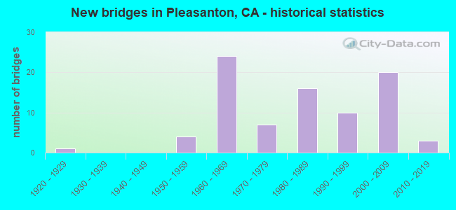
- New bridges - historical statistics
- 11920-1929
- 41950-1959
- 241960-1969
- 71970-1979
- 161980-1989
- 101990-1999
- 202000-2009
- 32010-2019

- Reconstructed bridges - Historical Statistics
- 41980-1989
- 101990-1999
- 12000-2009
- 32010-2019


- Bridge Condition - Deck
- 52.0%Good
- 36.0%Fair
- 12.0%Poor

- Bridge Condition - Superstructure
- 82.0%Good
- 18.0%Fair

- Bridge Condition - Substructure
- 90.0%Good
- 10.0%Fair

- Bridge Condition - Channel
- 13.0%Excellent
- 58.7%Very good
- 15.2%Good
- 13.0%Satisfactory

- Bridge Condition - Culverts
- 30.8%Good
- 69.2%Satisfactory
Find on map >> Show street view
Structure Number: 33 0012, Location: 04-ALA-580-13.82 (Lat: 37.700997, Lng: -121.796544), Route carried "on" structure: Interstate 580, Year Built: 1972, Year Reconstructed: 2011, Status: Open, Structure Length: 5.30m (17.39ft), Average Daily Traffic: 208,000 (year 2017), Truck Traffic: 14%, Average Future Daily Traffic: 297,391 (year 2042), Design Load: HS 20, Features Intersected: ARROYO LAS POSITAS
Minimum Vertical Clearance: 30+ m (98+ ft), Kilometerpoint: 13.820, Lanes on structure: 12, Base Highway Network: Yes (Inventory Route: 5, Subroute: 1), Owner: State Highway Agency, Approaching Roadway Width: 54.4m (178.5ft), Skew: 33 degrees, Material/Design: Concrete continuous, Design/Construction: Tee Beam, Number Of Spans In Main Unit: 3, Length of Maximum Span: 21.3m (69.9ft), Curb-To-Curb Width: 54.4m (178.5ft), Out-to-Out Width: 55.8m (183.1ft)
Condition: Deck: Fair, Superstructure: Good, Substructure: Good, Channel: Satisfactory, Operating Rating: 35.0 metric tons, Method Used To Determine Operating Rating: Load and Resistance Factor Rating (LRFR) rating reported by rating factor(RF) method using HL-93 loadings, Inventory Rating: 26.9 metric tons, Method Used To Determine Inventory Rating: Load and Resistance Factor Rating (LRFR) rating reported by rating factor(RF) method using HL-93 loadings, Structural Evaluation: Equal to present minimum criteria, Deck Geometry: Superior to present desirable criteria, Waterway Adequacy: Superior to present desirable criteria, Approach Roadway Alignment: Equal to present desirable criteria, Designated Inspection Frequency: Every 24 months, Inspection Date: Febuary 2022, Deck Structure Type: Concrete Cast-file-Place, Wearing Surface/Protective System: Wearing Surface: Bituminous
Find on map >> Show street view
Structure Number: 33 0014, Location: 04-ALA-580-17.57-PLE (Lat: 37.701633, Lng: -121.865097), Route carried "on" structure: Interstate 580, Year Built: 1970, Status: Open, Structure Length: 1.37m (4.49ft), Average Daily Traffic: 221,000 (year 2017), Truck Traffic: 14%, Average Future Daily Traffic: 301,986 (year 2040), Features Intersected: RANCHO DRAIN
Minimum Vertical Clearance: 30+ m (98+ ft), Kilometerpoint: 17.570, Lanes on structure: 14, Base Highway Network: Yes (Inventory Route: 5, Subroute: 1), Owner: State Highway Agency, Approaching Roadway Width: 67.1m (220.1ft), Skew: 30 degrees, Material/Design: Concrete continuous, Design/Construction: Culvert, Number Of Spans In Main Unit: 3, Length of Maximum Span: 4.3m (14.1ft), Curb-To-Curb Width: 67.1m (220.1ft), Out-to-Out Width: 92.9m (304.8ft)
Condition: Channel: Very good, Culverts: Satisfactory, Operating Rating: 54.1 metric tons, Method Used To Determine Operating Rating: Field evaluation and documented engineering judgment, Inventory Rating: 32.4 metric tons, Method Used To Determine Inventory Rating: Field evaluation and documented engineering judgment, Structural Evaluation: Equal to present minimum criteria, Deck Geometry: Superior to present desirable criteria, Waterway Adequacy: Equal to present desirable criteria, Approach Roadway Alignment: Equal to present desirable criteria, Designated Inspection Frequency: Every 24 months, Inspection Date: Febuary 2022
Find on map >> Show street view
Structure Number: 33 0015L, Location: 04-ALA-580-18.32-PLE (Lat: 37.701478, Lng: -121.878889), Route carried "on" structure: Interstate 580, Year Built: 1966, Year Reconstructed: 2015, Status: Open, Structure Length: 2.87m (9.42ft), Average Daily Traffic: 102,500 (year 2017), Truck Traffic: 14%, Average Future Daily Traffic: 150,993 (year 2040), Design Load: HS 20, Features Intersected: TASSAJARA CREEK
Minimum Vertical Clearance: 30+ m (98+ ft), Kilometerpoint: 18.320, Lanes on structure: 6, Base Highway Network: Yes (Inventory Route: 5, Subroute: 1), Owner: State Highway Agency, Approaching Roadway Width: 30.5m (100.1ft), Material/Design: Concrete continuous, Design/Construction: Slab, Number Of Spans In Main Unit: 3, Length of Maximum Span: 9.8m (32.2ft), Curb-To-Curb Width: 30.5m (100.1ft), Out-to-Out Width: 31.3m (102.7ft)
Condition: Deck: Fair, Superstructure: Fair, Substructure: Good, Channel: Very good, Operating Rating: 54.1 metric tons, Method Used To Determine Operating Rating: Assigned rating based on Load Factor Design (LFD) reported in metric tons, Inventory Rating: 32.4 metric tons, Method Used To Determine Inventory Rating: Assigned rating based on Load Factor Design (LFD) reported in metric tons, Structural Evaluation: Somewhat better than minimum adequacy, Deck Geometry: Superior to present desirable criteria, Waterway Adequacy: Equal to present desirable criteria, Approach Roadway Alignment: Equal to present desirable criteria, Designated Inspection Frequency: Every 24 months, Inspection Date: Febuary 2022, Deck Structure Type: Concrete Cast-file-Place
Find on map >> Show street view
Structure Number: 33 0015R, Location: 04-ALA-580-18.32-PLE (Lat: 37.701764, Lng: -121.878833), Route carried "on" structure: Interstate 580, Year Built: 1966, Year Reconstructed: 2015, Status: Open, Structure Length: 2.87m (9.42ft), Average Daily Traffic: 102,500 (year 2017), Truck Traffic: 14%, Average Future Daily Traffic: 150,993 (year 2040), Design Load: HS 20, Features Intersected: TASSAJARA CREEK
Minimum Vertical Clearance: 30+ m (98+ ft), Kilometerpoint: 18.320, Lanes on structure: 6, Base Highway Network: Yes (Inventory Route: 5, Subroute: 1), Owner: State Highway Agency, Approaching Roadway Width: 29.1m (95.5ft), Material/Design: Concrete continuous, Design/Construction: Slab, Number Of Spans In Main Unit: 3, Length of Maximum Span: 9.8m (32.2ft), Curb-To-Curb Width: 29.1m (95.5ft), Out-to-Out Width: 30.0m (98.4ft)
Condition: Deck: Good, Superstructure: Good, Substructure: Good, Channel: Very good, Operating Rating: 54.1 metric tons, Method Used To Determine Operating Rating: Assigned rating based on Load Factor Design (LFD) reported in metric tons, Inventory Rating: 32.4 metric tons, Method Used To Determine Inventory Rating: Assigned rating based on Load Factor Design (LFD) reported in metric tons, Structural Evaluation: Better than present minimum criteria, Deck Geometry: Better than present minimum criteria, Waterway Adequacy: Equal to present desirable criteria, Approach Roadway Alignment: Equal to present desirable criteria, Designated Inspection Frequency: Every 24 months, Inspection Date: Febuary 2022, Deck Structure Type: Concrete Cast-file-Place, Wearing Surface/Protective System: Wearing Surface: Bituminous
Find on map >> Show street view
Structure Number: 33 0015Y, Location: 04-ALA-580-18.32-PLE (Lat: 37.701908, Lng: -121.878803), Route carried "on" structure: Interstate 580, Year Built: 1965, Status: Open, Structure Length: 2.87m (9.42ft), Average Daily Traffic: 2 (year 2017), Average Future Daily Traffic: 3 (year 2042), Design Load: HS 20, Features Intersected: TASSAJARA CREEK, Facility Carried by Structure: NONE
Minimum Vertical Clearance: 30+ m (98+ ft), Kilometerpoint: 18.320, Lanes on structure: 2, Base Highway Network: Yes (Inventory Route: 5, Subroute: 1), Owner: State Highway Agency, Approaching Roadway Width: 9.8m (32.2ft), Material/Design: Concrete continuous, Design/Construction: Slab, Number Of Spans In Main Unit: 3, Length of Maximum Span: 9.8m (32.2ft), Curb or Sidewalk Widths: Left: 0.6m (2.0ft), Right: 0.0m, Curb-To-Curb Width: 9.8m (32.2ft), Out-to-Out Width: 11.0m (36.1ft)
Condition: Deck: Fair, Superstructure: Fair, Substructure: Good, Channel: Very good, Operating Rating: 71.3 metric tons, Method Used To Determine Operating Rating: Load Factor (LF), Inventory Rating: 42.8 metric tons, Method Used To Determine Inventory Rating: Load Factor (LF), Structural Evaluation: Somewhat better than minimum adequacy, Deck Geometry: Equal to present desirable criteria, Waterway Adequacy: Equal to present desirable criteria, Approach Roadway Alignment: Equal to present desirable criteria, Designated Inspection Frequency: Every 24 months, Inspection Date: Febuary 2022, Deck Structure Type: Concrete Cast-file-Place
Find on map >> Show street view
Structure Number: 33 0016G, Location: 04-ALA-580-20.56-PLE (Lat: 37.701961, Lng: -121.919683), Route carried "on" structure: Ramp Interstate 580, Year Built: 1965, Year Reconstructed: 1991, Status: Open, Structure Length: 5.27m (17.29ft), Average Daily Traffic: 42,200 (year 2012), Truck Traffic: 11%, Average Future Daily Traffic: 43,039 (year 2042), Design Load: HS 20, Features Intersected: ALAMO CANAL
Minimum Vertical Clearance: 30+ m (98+ ft), Kilometerpoint: 20.560, Lanes on structure: 2, Owner: State Highway Agency, Approaching Roadway Width: 11.8m (38.7ft), Material/Design: Concrete continuous, Design/Construction: Slab, Number Of Spans In Main Unit: 8, Length of Maximum Span: 6.7m (22.0ft), Curb or Sidewalk Widths: Left: 0.6m (2.0ft), Right: 0.0m, Curb-To-Curb Width: 11.8m (38.7ft), Out-to-Out Width: 13.3m (43.6ft)
Condition: Deck: Good, Superstructure: Good, Substructure: Good, Channel: Satisfactory, Operating Rating: 37.3 metric tons, Method Used To Determine Operating Rating: Load and Resistance Factor Rating (LRFR) rating reported by rating factor(RF) method using HL-93 loadings, Inventory Rating: 28.8 metric tons, Method Used To Determine Inventory Rating: Load and Resistance Factor Rating (LRFR) rating reported by rating factor(RF) method using HL-93 loadings, Structural Evaluation: Better than present minimum criteria, Deck Geometry: Superior to present desirable criteria, Waterway Adequacy: Equal to present desirable criteria, Approach Roadway Alignment: Better than present minimum criteria, Designated Inspection Frequency: Every 24 months, Inspection Date: Febuary 2022, Deck Structure Type: Concrete Cast-file-Place
Find on map >> Show street view
Structure Number: 33 0016L, Location: 04-ALA-580-20.56-PLE (Lat: 37.701542, Lng: -121.919650), Route carried "on" structure: Interstate 580, Year Built: 1952, Year Reconstructed: 1996, Status: Open, Structure Length: 4.60m (15.09ft), Average Daily Traffic: 102,900 (year 2017), Truck Traffic: 7%, Average Future Daily Traffic: 150,471 (year 2040), Design Load: HS 20, Features Intersected: ALAMO CANAL
Minimum Vertical Clearance: 30+ m (98+ ft), Kilometerpoint: 20.560, Lanes on structure: 4, Base Highway Network: Yes (Inventory Route: 5, Subroute: 1), Owner: State Highway Agency, Approaching Roadway Width: 19.2m (63.0ft), Material/Design: Concrete continuous, Design/Construction: Slab, Number Of Spans In Main Unit: 7, Length of Maximum Span: 6.7m (22.0ft), Curb-To-Curb Width: 19.2m (63.0ft), Out-to-Out Width: 20.3m (66.6ft)
Condition: Deck: Fair, Superstructure: Fair, Substructure: Good, Channel: Satisfactory, Operating Rating: 50.5 metric tons, Method Used To Determine Operating Rating: Load Factor (LF), Inventory Rating: 30.5 metric tons, Method Used To Determine Inventory Rating: Load Factor (LF), Structural Evaluation: Somewhat better than minimum adequacy, Deck Geometry: Somewhat better than minimum adequacy, Waterway Adequacy: Better than present minimum criteria, Approach Roadway Alignment: Better than present minimum criteria, Length Of Structure Improvement: 4.60m (15.09ft), Designated Inspection Frequency: Every 24 months, Inspection Date: Febuary 2022, Deck Structure Type: Concrete Cast-file-Place
Find on map >> Show street view
Structure Number: 33 0016R, Location: 04-ALA-580-20.56-PLE (Lat: 37.701828, Lng: -121.919736), Route carried "on" structure: Interstate 580, Year Built: 1952, Year Reconstructed: 1996, Status: Open, Structure Length: 4.60m (15.09ft), Average Daily Traffic: 102,900 (year 2017), Truck Traffic: 7%, Average Future Daily Traffic: 150,471 (year 2040), Design Load: HS 20, Features Intersected: ALAMO CANAL
Minimum Vertical Clearance: 30+ m (98+ ft), Kilometerpoint: 20.560, Lanes on structure: 4, Base Highway Network: Yes (Inventory Route: 5, Subroute: 1), Owner: State Highway Agency, Approaching Roadway Width: 19.2m (63.0ft), Material/Design: Concrete continuous, Design/Construction: Slab, Number Of Spans In Main Unit: 7, Length of Maximum Span: 6.7m (22.0ft), Curb-To-Curb Width: 19.2m (63.0ft), Out-to-Out Width: 20.3m (66.6ft)
Condition: Deck: Good, Superstructure: Good, Substructure: Good, Channel: Good, Operating Rating: 55.7 metric tons, Method Used To Determine Operating Rating: Load Factor (LF), Inventory Rating: 33.7 metric tons, Method Used To Determine Inventory Rating: Load Factor (LF), Structural Evaluation: Better than present minimum criteria, Deck Geometry: Somewhat better than minimum adequacy, Waterway Adequacy: Equal to present desirable criteria, Approach Roadway Alignment: Equal to present desirable criteria, Length Of Structure Improvement: 4.60m (15.09ft), Designated Inspection Frequency: Every 24 months, Inspection Date: Febuary 2022, Deck Structure Type: Concrete Cast-file-Place, Wearing Surface/Protective System: Wearing Surface: Integral Concrete
Find on map >> Show street view
Structure Number: 33 0150R, Location: 04-ALA-580-19.35-PLE (Lat: 37.702006, Lng: -121.898375), Route carried "on" structure: Interstate 580, Year Built: 1994, Year Reconstructed: 2015, Status: Open, Structure Length: 4.81m (15.78ft), Average Daily Traffic: 127,000 (year 2017), Truck Traffic: 14%, Average Future Daily Traffic: 150,993 (year 2040), Design Load: HS 20+Mod, Features Intersected: DEMARCUS BLVD (BARTD)
Minimum Vertical Clearance: 30+ m (98+ ft), Kilometerpoint: 19.350, Lanes on structure: 6, Lanes under structure: 2, Base Highway Network: Yes (Inventory Route: 5, Subroute: 1), Owner: State Highway Agency, Approaching Roadway Width: 29.4m (96.5ft), Skew: 4 degrees, Material/Design: Concrete continuous, Design/Construction: Box Beam or Girders - Multiple, Number Of Spans In Main Unit: 2, Length of Maximum Span: 24.0m (78.7ft), Curb-To-Curb Width: 29.4m (96.5ft), Out-to-Out Width: 30.5m (100.1ft)
Condition: Deck: Good, Superstructure: Good, Substructure: Fair, Operating Rating: 54.1 metric tons, Method Used To Determine Operating Rating: Assigned rating based on Load Factor Design (LFD) reported in metric tons, Inventory Rating: 32.4 metric tons, Method Used To Determine Inventory Rating: Assigned rating based on Load Factor Design (LFD) reported in metric tons, Structural Evaluation: Somewhat better than minimum adequacy, Deck Geometry: Better than present minimum criteria, Underclear: High priority of corrective action, Approach Roadway Alignment: Equal to present desirable criteria, Designated Inspection Frequency: Every 24 months, Inspection Date: Febuary 2022, Deck Structure Type: Concrete Cast-file-Place
Find on map >> Show street view
Structure Number: 33 0371, Location: 04-ALA-680-R20.03-PLE (Lat: 37.700642, Lng: -121.922308), Route carried "on" structure: Interstate 680, Year Built: 1965, Year Reconstructed: 2002, Status: Open, Structure Length: 9.91m (32.51ft), Average Daily Traffic: 146,000 (year 2009), Truck Traffic: 6%, Average Future Daily Traffic: 213,855 (year 2040), Design Load: HS 20+Mod, Features Intersected: INTERSTATE 580
Minimum Vertical Clearance: 30+ m (98+ ft), Kilometerpoint: 20.030, Lanes on structure: 7, Lanes under structure: 10, Base Highway Network: Yes (Inventory Route: 6, Subroute: 1), Owner: State Highway Agency, Approaching Roadway Width: 51.7m (169.6ft), Skew: 30 degrees, Material/Design: Steel continuous, Design/Construction: Stringer/Multi-beam, Number Of Spans In Main Unit: 4, Length of Maximum Span: 25.9m (85.0ft), Curb or Sidewalk Widths: Left: 0.6m (2.0ft), Right: 0.0m, Curb-To-Curb Width: 51.7m (169.6ft), Out-to-Out Width: 53.2m (174.5ft)
Condition: Deck: Good, Superstructure: Good, Substructure: Good, Operating Rating: 24.0 metric tons, Method Used To Determine Operating Rating: Load and Resistance Factor Rating (LRFR) rating reported by rating factor(RF) method using HL-93 loadings, Inventory Rating: 18.5 metric tons, Method Used To Determine Inventory Rating: Load and Resistance Factor Rating (LRFR) rating reported by rating factor(RF) method using HL-93 loadings, Structural Evaluation: Meets minimum limits, Deck Geometry: Superior to present desirable criteria, Underclear: Meets minimum limits, Approach Roadway Alignment: Equal to present desirable criteria, Designated Inspection Frequency: Every 24 months, Inspection Date: April 2020, Deck Structure Type: Concrete Cast-file-Place
Find on map >> Show street view
Structure Number: 33 0371G, Location: 04-ALA-680-R20.03-PLE (Lat: 37.701094, Lng: -121.922419), Route carried "on" structure: Ramp Interstate 680, Year Built: 1965, Status: Open, Structure Length: 9.91m (32.51ft), Average Daily Traffic: 22,700 (year 2009), Truck Traffic: 8%, Average Future Daily Traffic: 31,535 (year 2042), Design Load: HS 20, Features Intersected: E580-N680,580,N680-W580
Minimum Vertical Clearance: 30+ m (98+ ft), Kilometerpoint: 20.030, Lanes on structure: 2, Lanes under structure: 10, Base Highway Network: Yes (Inventory Route: 6, Subroute: 1), Owner: State Highway Agency, Approaching Roadway Width: 8.6m (28.2ft), Material/Design: Steel, Design/Construction: Orthotropic, Number Of Spans In Main Unit: 4, Length of Maximum Span: 25.9m (85.0ft), Curb or Sidewalk Widths: Left: 0.6m (2.0ft), Right: 0.6m (2.0ft), Curb-To-Curb Width: 8.6m (28.2ft), Out-to-Out Width: 10.4m (34.1ft)
Condition: Deck: Good, Superstructure: Good, Substructure: Good, Operating Rating: 47.3 metric tons, Method Used To Determine Operating Rating: Load Factor (LF), Inventory Rating: 28.2 metric tons, Method Used To Determine Inventory Rating: Load Factor (LF), Structural Evaluation: Better than present minimum criteria, Deck Geometry: Meets minimum limits, Underclear: Equal to present minimum criteria, Approach Roadway Alignment: Equal to present desirable criteria, Length Of Structure Improvement: 9.91m (32.51ft), Designated Inspection Frequency: Every 24 months, Critical Feature Inspection Frequency: Every 24 months, Inspection Date: April 2020, Critical Feature Inspection Date: Febuary 2022, Deck Structure Type: Steel plate, Wearing Surface/Protective System: Wearing Surface: Bituminous
Find on map >> Show street view
Structure Number: 33 0381, Location: 04-ALA-680-R15.98-PLE (Lat: 37.648078, Lng: -121.892214), Route carried "on" structure: Interstate 680, Year Built: 1967, Year Reconstructed: 1990, Status: Open, Structure Length: 4.24m (13.91ft), Average Daily Traffic: 122,000 (year 2009), Truck Traffic: 10%, Average Future Daily Traffic: 193,388 (year 2040), Design Load: HS 20, Features Intersected: LAGUNA CREEK LANE
Minimum Vertical Clearance: 30+ m (98+ ft), Kilometerpoint: 15.980, Lanes on structure: 6, Lanes under structure: 2, Base Highway Network: Yes (Inventory Route: 6, Subroute: 1), Owner: State Highway Agency, Approaching Roadway Width: 38.2m (125.3ft), Skew: 31 degrees, Material/Design: Concrete continuous, Design/Construction: Box Beam or Girders - Multiple, Number Of Spans In Main Unit: 3, Length of Maximum Span: 17.7m (58.1ft), Curb-To-Curb Width: 38.2m (125.3ft), Out-to-Out Width: 39.4m (129.3ft)
Condition: Deck: Fair, Superstructure: Good, Substructure: Good, Operating Rating: 40.5 metric tons, Method Used To Determine Operating Rating: Load and Resistance Factor Rating (LRFR) rating reported by rating factor(RF) method using HL-93 loadings, Inventory Rating: 28.8 metric tons, Method Used To Determine Inventory Rating: Load and Resistance Factor Rating (LRFR) rating reported by rating factor(RF) method using HL-93 loadings, Structural Evaluation: Better than present minimum criteria, Deck Geometry: Superior to present desirable criteria, Underclear: High priority of corrective action, Approach Roadway Alignment: Equal to present desirable criteria, Designated Inspection Frequency: Every 24 months, Inspection Date: April 2020, Deck Structure Type: Concrete Cast-file-Place
Find on map >> Show street view
Structure Number: 33 0382, Location: 04-ALA-680-R17.19-PLE (Lat: 37.661667, Lng: -121.906161), Route carried "on" structure: Interstate 680, Year Built: 1967, Year Reconstructed: 1990, Status: Open, Structure Length: 7.19m (23.59ft), Average Daily Traffic: 146,000 (year 2009), Truck Traffic: 6%, Average Future Daily Traffic: 213,855 (year 2040), Design Load: HS 20, Features Intersected: ARROYO DE LA LAGUNA
Minimum Vertical Clearance: 30+ m (98+ ft), Kilometerpoint: 17.190, Lanes on structure: 6, Base Highway Network: Yes (Inventory Route: 6, Subroute: 1), Owner: State Highway Agency, Approaching Roadway Width: 38.3m (125.7ft), Skew: 31 degrees, Material/Design: Concrete continuous, Design/Construction: Box Beam or Girders - Multiple, Number Of Spans In Main Unit: 3, Length of Maximum Span: 29.0m (95.1ft), Curb-To-Curb Width: 38.3m (125.7ft), Out-to-Out Width: 39.5m (129.6ft)
Condition: Deck: Fair, Superstructure: Good, Substructure: Good, Channel: Very good, Operating Rating: 41.5 metric tons, Method Used To Determine Operating Rating: Load and Resistance Factor Rating (LRFR) rating reported by rating factor(RF) method using HL-93 loadings, Inventory Rating: 32.1 metric tons, Method Used To Determine Inventory Rating: Load and Resistance Factor Rating (LRFR) rating reported by rating factor(RF) method using HL-93 loadings, Structural Evaluation: Better than present minimum criteria, Deck Geometry: Superior to present desirable criteria, Waterway Adequacy: Equal to present desirable criteria, Approach Roadway Alignment: Equal to present desirable criteria, Length Of Structure Improvement: 7.19m (23.59ft), Designated Inspection Frequency: Every 24 months, Inspection Date: April 2020, Deck Structure Type: Concrete Cast-file-Place
Find on map >> Show street view
Structure Number: 33 0383, Location: 04-ALA-680-R16.75 (Lat: 37.656628, Lng: -121.901097), Route carried "on" structure: Interstate 680, Year Built: 1967, Year Reconstructed: 1990, Status: Open, Structure Length: 5.49m (18.01ft), Average Daily Traffic: 136,000 (year 2009), Truck Traffic: 10%, Average Future Daily Traffic: 194,850 (year 2040), Design Load: HS 20, Features Intersected: BERNAL AVE
Minimum Vertical Clearance: 30+ m (98+ ft), Kilometerpoint: 16.750, Lanes on structure: 6, Lanes under structure: 5, Base Highway Network: Yes (Inventory Route: 6, Subroute: 1), Owner: State Highway Agency, Approaching Roadway Width: 38.4m (126.0ft), Skew: 31 degrees, Material/Design: Concrete continuous, Design/Construction: Box Beam or Girders - Multiple, Number Of Spans In Main Unit: 3, Length of Maximum Span: 30.5m (100.1ft), Curb-To-Curb Width: 38.4m (126.0ft), Out-to-Out Width: 39.6m (129.9ft)
Condition: Deck: Poor, Superstructure: Good, Substructure: Good, Operating Rating: 54.1 metric tons, Method Used To Determine Operating Rating: Assigned rating based on Load Factor Design (LFD) reported in metric tons, Inventory Rating: 32.4 metric tons, Method Used To Determine Inventory Rating: Assigned rating based on Load Factor Design (LFD) reported in metric tons, Structural Evaluation: Better than present minimum criteria, Deck Geometry: Superior to present desirable criteria, Underclear: Equal to present minimum criteria, Approach Roadway Alignment: Equal to present desirable criteria, Designated Inspection Frequency: Every 24 months, Inspection Date: April 2020, Deck Structure Type: Concrete Cast-file-Place
Find on map >> Show street view
Structure Number: 33 0383K, Location: 04-ALA-680-R16.75-PLE (Lat: 37.656431, Lng: -121.901614), Route carried "on" structure: Ramp Interstate 680, Year Built: 1967, Status: Open, Structure Length: 5.39m (17.68ft), Average Daily Traffic: 1,950 (year 2009), Truck Traffic: 2%, Average Future Daily Traffic: 2,137 (year 2042), Design Load: HS 20, Features Intersected: BERNAL AVE
Minimum Vertical Clearance: 30+ m (98+ ft), Kilometerpoint: 16.750, Lanes on structure: 1, Lanes under structure: 4, Base Highway Network: Yes (Inventory Route: 6, Subroute: 1), Owner: State Highway Agency, Approaching Roadway Width: 6.7m (22.0ft), Material/Design: Concrete continuous, Design/Construction: Box Beam or Girders - Multiple, Number Of Spans In Main Unit: 3, Length of Maximum Span: 29.9m (98.1ft), Curb or Sidewalk Widths: Left: 0.0m, Right: 0.6m (2.0ft), Curb-To-Curb Width: 6.7m (22.0ft), Out-to-Out Width: 7.9m (25.9ft)
Condition: Deck: Fair, Superstructure: Good, Substructure: Good, Operating Rating: 35.6 metric tons, Method Used To Determine Operating Rating: Load and Resistance Factor Rating (LRFR) rating reported by rating factor(RF) method using HL-93 loadings, Inventory Rating: 27.5 metric tons, Method Used To Determine Inventory Rating: Load and Resistance Factor Rating (LRFR) rating reported by rating factor(RF) method using HL-93 loadings, Structural Evaluation: Equal to present minimum criteria, Deck Geometry: Equal to present minimum criteria, Underclear: Meets minimum limits, Approach Roadway Alignment: Equal to present desirable criteria, Designated Inspection Frequency: Every 24 months, Inspection Date: April 2020, Deck Structure Type: Concrete Cast-file-Place
Find on map >> Show street view
Structure Number: 33 0385, Location: 04-ALA-680-R15.04-PLE (Lat: 37.636561, Lng: -121.884064), Route carried "on" structure: Interstate 680, Year Built: 1967, Year Reconstructed: 1990, Status: Open, Structure Length: 5.21m (17.09ft), Average Daily Traffic: 124,000 (year 2009), Truck Traffic: 10%, Average Future Daily Traffic: 194,850 (year 2040), Design Load: HS 20, Features Intersected: HAPPY VALLEY ROAD
Minimum Vertical Clearance: 30+ m (98+ ft), Kilometerpoint: 15.040, Lanes on structure: 6, Lanes under structure: 2, Base Highway Network: Yes (Inventory Route: 6, Subroute: 1), Owner: State Highway Agency, Approaching Roadway Width: 37.9m (124.3ft), Skew: 30 degrees, Material/Design: Concrete continuous, Design/Construction: Box Beam or Girders - Multiple, Number Of Spans In Main Unit: 3, Length of Maximum Span: 21.6m (70.9ft), Curb-To-Curb Width: 37.9m (124.3ft), Out-to-Out Width: 39.1m (128.3ft)
Condition: Deck: Poor, Superstructure: Good, Substructure: Good, Operating Rating: 54.1 metric tons, Method Used To Determine Operating Rating: Assigned rating based on Load Factor Design (LFD) reported in metric tons, Inventory Rating: 32.4 metric tons, Method Used To Determine Inventory Rating: Assigned rating based on Load Factor Design (LFD) reported in metric tons, Structural Evaluation: Better than present minimum criteria, Deck Geometry: Superior to present desirable criteria, Underclear: Better than present minimum criteria, Approach Roadway Alignment: Equal to present desirable criteria, Length Of Structure Improvement: 5.21m (17.09ft), Designated Inspection Frequency: Every 24 months, Inspection Date: April 2020, Bridge Improvement Cost: $2,065,000, Roadway Improvement Cost: $413,000, Total Project Cost: $3,469,000 ( Estimate for 2021), Deck Structure Type: Concrete Cast-file-Place
Find on map >> Show street view
Structure Number: 33 0387, Location: 04-ALA-680-R15.26-PLE (Lat: 37.639778, Lng: -121.884297), Route carried "on" structure: Interstate 680, Year Built: 1967, Year Reconstructed: 1990, Status: Open, Structure Length: 5.30m (17.39ft), Average Daily Traffic: 122,000 (year 2009), Truck Traffic: 10%, Average Future Daily Traffic: 193,388 (year 2040), Design Load: HS 20, Features Intersected: PLEASANTON-SUNOL ROAD
Minimum Vertical Clearance: 30+ m (98+ ft), Kilometerpoint: 15.260, Lanes on structure: 6, Lanes under structure: 2, Base Highway Network: Yes (Inventory Route: 6, Subroute: 1), Owner: State Highway Agency, Approaching Roadway Width: 38.0m (124.7ft), Skew: 31 degrees, Material/Design: Concrete continuous, Design/Construction: Box Beam or Girders - Multiple, Number Of Spans In Main Unit: 3, Length of Maximum Span: 25.3m (83.0ft), Curb-To-Curb Width: 38.0m (124.7ft), Out-to-Out Width: 39.2m (128.6ft)
Condition: Deck: Poor, Superstructure: Good, Substructure: Good, Operating Rating: 54.1 metric tons, Method Used To Determine Operating Rating: Assigned rating based on Load Factor Design (LFD) reported in metric tons, Inventory Rating: 32.4 metric tons, Method Used To Determine Inventory Rating: Assigned rating based on Load Factor Design (LFD) reported in metric tons, Structural Evaluation: Better than present minimum criteria, Deck Geometry: Superior to present desirable criteria, Underclear: Meets minimum limits, Approach Roadway Alignment: Equal to present desirable criteria, Length Of Structure Improvement: 5.30m (17.39ft), Designated Inspection Frequency: Every 24 months, Inspection Date: April 2020, Bridge Improvement Cost: $2,078,000, Roadway Improvement Cost: $415,000, Total Project Cost: $3,491,000 ( Estimate for 2021), Deck Structure Type: Concrete Cast-file-Place
Find on map >> Show street view
Structure Number: 33 0387K, Location: 04-ALA-680-R15.26-PLE (Lat: 37.639567, Lng: -121.884683), Route carried "on" structure: Ramp Interstate 680, Year Built: 1967, Status: Open, Structure Length: 5.24m (17.19ft), Average Daily Traffic: 3,550 (year 2009), Truck Traffic: 9%, Average Future Daily Traffic: 5,256 (year 2038), Design Load: HS 20, Features Intersected: PLEASANTON-SUNOL ROAD
Minimum Vertical Clearance: 30+ m (98+ ft), Kilometerpoint: 15.260, Lanes on structure: 1, Lanes under structure: 3, Base Highway Network: Yes (Inventory Route: 6, Subroute: 1), Owner: State Highway Agency, Approaching Roadway Width: 6.7m (22.0ft), Skew: 1 degrees, Material/Design: Concrete continuous, Design/Construction: Box Beam or Girders - Multiple, Number Of Spans In Main Unit: 3, Length of Maximum Span: 25.0m (82.0ft), Curb or Sidewalk Widths: Left: 0.0m, Right: 0.6m (2.0ft), Curb-To-Curb Width: 6.7m (22.0ft), Out-to-Out Width: 7.9m (25.9ft)
Condition: Deck: Poor, Superstructure: Good, Substructure: Good, Operating Rating: 41.1 metric tons, Method Used To Determine Operating Rating: Load and Resistance Factor Rating (LRFR) rating reported by rating factor(RF) method using HL-93 loadings, Inventory Rating: 30.8 metric tons, Method Used To Determine Inventory Rating: Load and Resistance Factor Rating (LRFR) rating reported by rating factor(RF) method using HL-93 loadings, Structural Evaluation: Better than present minimum criteria, Deck Geometry: Equal to present minimum criteria, Underclear: High priority of corrective action, Approach Roadway Alignment: Equal to present desirable criteria, Designated Inspection Frequency: Every 24 months, Inspection Date: April 2020, Deck Structure Type: Concrete Cast-file-Place
Find on map >> Show street view
Structure Number: 33 0388, Location: 04-ALA-680-R15.62-PLE (Lat: 37.644158, Lng: -121.888111), Route carried "on" structure: Interstate 680, Year Built: 1967, Year Reconstructed: 1990, Status: Open, Structure Length: 5.58m (18.31ft), Average Daily Traffic: 122,000 (year 2009), Truck Traffic: 10%, Average Future Daily Traffic: 193,388 (year 2040), Design Load: HS 20+Mod, Features Intersected: ABANDONED UP RR R/W
Minimum Vertical Clearance: 30+ m (98+ ft), Kilometerpoint: 15.620, Lanes on structure: 6, Base Highway Network: Yes (Inventory Route: 6, Subroute: 1), Owner: State Highway Agency, Approaching Roadway Width: 39.2m (128.6ft), Skew: 34 degrees, Material/Design: Concrete continuous, Design/Construction: Box Beam or Girders - Multiple, Number Of Spans In Main Unit: 3, Length of Maximum Span: 24.1m (79.1ft), Curb-To-Curb Width: 39.0m (128.0ft), Out-to-Out Width: 40.2m (131.9ft)
Condition: Deck: Poor, Superstructure: Good, Substructure: Good, Operating Rating: 54.1 metric tons, Method Used To Determine Operating Rating: Assigned rating based on Load Factor Design (LFD) reported in metric tons, Inventory Rating: 32.4 metric tons, Method Used To Determine Inventory Rating: Assigned rating based on Load Factor Design (LFD) reported in metric tons, Structural Evaluation: Better than present minimum criteria, Deck Geometry: Superior to present desirable criteria, Approach Roadway Alignment: Equal to present desirable criteria, Length Of Structure Improvement: 5.58m (18.31ft), Designated Inspection Frequency: Every 24 months, Inspection Date: April 2020, Bridge Improvement Cost: $2,254,000, Roadway Improvement Cost: $450,000, Total Project Cost: $3,786,000 ( Estimate for 2021), Deck Structure Type: Concrete Cast-file-Place
Find on map >> Show street view
Structure Number: 33 0474, Location: 04-ALA-580-19.72-PLE (Lat: 37.701919, Lng: -121.903414), Route carried "on" structure: Interstate 580, Year Built: 1994, Status: Open, Structure Length: 0.81m (2.66ft), Average Daily Traffic: 254,000 (year 2017), Truck Traffic: 7%, Average Future Daily Traffic: 300,941 (year 2040), Features Intersected: CHABOT CANAL
Minimum Vertical Clearance: 30+ m (98+ ft), Kilometerpoint: 19.720, Lanes on structure: 14, Base Highway Network: Yes (Inventory Route: 5, Subroute: 1), Owner: State Highway Agency, Approaching Roadway Width: 47.5m (155.8ft), Skew: 21 degrees, Material/Design: Concrete continuous, Design/Construction: Culvert, Number Of Spans In Main Unit: 3, Length of Maximum Span: 2.4m (7.9ft)
Condition: Channel: Very good, Culverts: Good, Operating Rating: 54.1 metric tons, Method Used To Determine Operating Rating: Field evaluation and documented engineering judgment, Inventory Rating: 32.4 metric tons, Method Used To Determine Inventory Rating: Field evaluation and documented engineering judgment, Structural Evaluation: Better than present minimum criteria, Waterway Adequacy: Equal to present desirable criteria, Approach Roadway Alignment: Equal to present desirable criteria, Designated Inspection Frequency: Every 24 months, Inspection Date: Febuary 2022
Find on map >> Show street view
Structure Number: 33 0507, Location: 04-ALA-680-R19.30-PLE (Lat: 37.690403, Lng: -121.918956), Route carried "on" structure: City street , Year Built: 1980, Year Reconstructed: 1991, Status: Open, Structure Length: 15.09m (49.51ft), Average Daily Traffic: 27,000 (year 2010), Truck Traffic: 2%, Average Future Daily Traffic: 39,419 (year 2042), Design Load: HS 20+Mod, Features Intersected: I 680, SO SAN RAMON CRK, Facility Carried by Structure: STONERIDGE DR
Minimum Vertical Clearance: 30+ m (98+ ft), Kilometerpoint: 0.000, Lanes on structure: 5, Lanes under structure: 8, Owner: State Highway Agency, Approaching Roadway Width: 21.2m (69.6ft), Skew: 32 degrees, Material/Design: Prestressed concrete continuous, Design/Construction: Box Beam or Girders - Multiple, Number Of Spans In Main Unit: 4, Length of Maximum Span: 39.7m (130.2ft), Curb or Sidewalk Widths: Left: 2.2m (7.2ft), Right: 0.0m, Curb-To-Curb Width: 21.0m (68.9ft), Out-to-Out Width: 25.9m (85.0ft)
Condition: Deck: Good, Superstructure: Good, Substructure: Good, Channel: Very good, Operating Rating: 54.1 metric tons, Method Used To Determine Operating Rating: Assigned rating based on Load Factor Design (LFD) reported in metric tons, Inventory Rating: 32.4 metric tons, Method Used To Determine Inventory Rating: Assigned rating based on Load Factor Design (LFD) reported in metric tons, Structural Evaluation: Better than present minimum criteria, Deck Geometry: Somewhat better than minimum adequacy, Underclear: Equal to present minimum criteria, Waterway Adequacy: Superior to present desirable criteria, Approach Roadway Alignment: Equal to present desirable criteria, Designated Inspection Frequency: Every 24 months, Inspection Date: April 2020, Deck Structure Type: Concrete Cast-file-Place
Find on map >> Show street view
Structure Number: 33 0516, Location: 04-ALA-680-R18.40-PLE (Lat: 37.677792, Lng: -121.914028), Route carried "on" structure: City street , Year Built: 1984, Status: Open, Structure Length: 13.56m (44.49ft), Average Daily Traffic: 3,500 (year 2009), Truck Traffic: 3%, Average Future Daily Traffic: 5,361 (year 2042), Design Load: HS 20+Mod, Features Intersected: I 680, SO SAN RAMON CRK, Facility Carried by Structure: W LAS POSITAS BLVD
Minimum Vertical Clearance: 30+ m (98+ ft), Kilometerpoint: 0.000, Lanes on structure: 2, Lanes under structure: 6, Owner: State Highway Agency, Approaching Roadway Width: 12.2m (40.0ft), Material/Design: Prestressed concrete continuous, Design/Construction: Box Beam or Girders - Multiple, Number Of Spans In Main Unit: 3, Length of Maximum Span: 54.9m (180.1ft), Curb or Sidewalk Widths: Left: 1.8m (5.9ft), Right: 0.0m, Curb-To-Curb Width: 12.2m (40.0ft), Out-to-Out Width: 14.6m (47.9ft)
Condition: Deck: Good, Superstructure: Good, Substructure: Good, Channel: Very good, Operating Rating: 54.1 metric tons, Method Used To Determine Operating Rating: Assigned rating based on Load Factor Design (LFD) reported in metric tons, Inventory Rating: 32.4 metric tons, Method Used To Determine Inventory Rating: Assigned rating based on Load Factor Design (LFD) reported in metric tons, Structural Evaluation: Better than present minimum criteria, Deck Geometry: Equal to present minimum criteria, Underclear: Equal to present minimum criteria, Waterway Adequacy: Superior to present desirable criteria, Approach Roadway Alignment: Equal to present desirable criteria, Designated Inspection Frequency: Every 24 months, Inspection Date: April 2020, Deck Structure Type: Concrete Cast-file-Place
Find on map >> Show street view
Structure Number: 33 0551, Location: 04-ALA-580-19.86-PLE (Lat: 37.701283, Lng: -121.906383), Route carried "on" structure: City street , Year Built: 1988, Year Reconstructed: 1994, Status: Open, Structure Length: 13.53m (44.39ft), Average Daily Traffic: 6,000 (year 1998), Truck Traffic: 5%, Average Future Daily Traffic: 12,035 (year 2042), Design Load: HS 20+Mod, Features Intersected: INTERSTATE 580, Facility Carried by Structure: HOPYARD DOUGHERTY
Minimum Vertical Clearance: 30+ m (98+ ft), Kilometerpoint: 0.000, Lanes on structure: 6, Lanes under structure: 13, Owner: State Highway Agency, Approaching Roadway Width: 32.1m (105.3ft), Skew: 23 degrees, Material/Design: Prestressed concrete continuous, Design/Construction: Box Beam or Girders - Multiple, Number Of Spans In Main Unit: 2, Length of Maximum Span: 74.4m (244.1ft), Curb or Sidewalk Widths: Left: 0.0m, Right: 2.4m (7.9ft), Curb-To-Curb Width: 32.1m (105.3ft), Out-to-Out Width: 37.0m (121.4ft)
Condition: Deck: Good, Superstructure: Good, Substructure: Good, Operating Rating: 54.1 metric tons, Method Used To Determine Operating Rating: Assigned rating based on Load Factor Design (LFD) reported in metric tons, Inventory Rating: 32.4 metric tons, Method Used To Determine Inventory Rating: Assigned rating based on Load Factor Design (LFD) reported in metric tons, Structural Evaluation: Better than present minimum criteria, Deck Geometry: Superior to present desirable criteria, Underclear: High priority of corrective action, Approach Roadway Alignment: Equal to present desirable criteria, Designated Inspection Frequency: Every 24 months, Inspection Date: Febuary 2022, Deck Structure Type: Concrete Cast-file-Place
Find on map >> Show street view
Structure Number: 33 0580S, Location: 04-ALA-680-R19.07-PLE (Lat: 37.688558, Lng: -121.917225), Route carried "on" structure: Ramp Interstate 680, Year Built: 1991, Status: Open, Structure Length: 7.99m (26.21ft), Average Daily Traffic: 2,300 (year 2010), Truck Traffic: 7%, Average Future Daily Traffic: 3,154 (year 2042), Design Load: HS 20+Mod, Features Intersected: SOUTH SAN RAMON CREEK
Minimum Vertical Clearance: 30+ m (98+ ft), Kilometerpoint: 19.070, Lanes on structure: 1, Owner: State Highway Agency, Approaching Roadway Width: 7.3m (24.0ft), Skew: 9 degrees, Material/Design: Concrete continuous, Design/Construction: Box Beam or Girders - Multiple, Number Of Spans In Main Unit: 3, Length of Maximum Span: 27.1m (88.9ft), Curb-To-Curb Width: 7.3m (24.0ft), Out-to-Out Width: 8.3m (27.2ft)
Condition: Deck: Fair, Superstructure: Good, Substructure: Good, Channel: Very good, Operating Rating: 54.1 metric tons, Method Used To Determine Operating Rating: Assigned rating based on Load Factor Design (LFD) reported in metric tons, Inventory Rating: 32.4 metric tons, Method Used To Determine Inventory Rating: Assigned rating based on Load Factor Design (LFD) reported in metric tons, Structural Evaluation: Better than present minimum criteria, Deck Geometry: Better than present minimum criteria, Waterway Adequacy: Equal to present desirable criteria, Approach Roadway Alignment: Equal to present desirable criteria, Designated Inspection Frequency: Every 24 months, Inspection Date: April 2020, Deck Structure Type: Concrete Cast-file-Place
Find on map >> Show street view
Structure Number: 33 0581S, Location: 04-ALA-680-R19.18-PLE (Lat: 37.689475, Lng: -121.917114), Route carried "on" structure: Ramp Interstate 680, Year Built: 1991, Status: Open, Structure Length: 5.79m (19.00ft), Average Daily Traffic: 2,200 (year 2010), Truck Traffic: 7%, Average Future Daily Traffic: 3,154 (year 2042), Design Load: HS 20+Mod, Features Intersected: SOUTH SAN RAMON CREEK
Minimum Vertical Clearance: 30+ m (98+ ft), Kilometerpoint: 19.180, Lanes on structure: 1, Owner: State Highway Agency, Approaching Roadway Width: 8.5m (27.9ft), Skew: 9 degrees, Material/Design: Concrete continuous, Design/Construction: Box Beam or Girders - Multiple, Number Of Spans In Main Unit: 3, Length of Maximum Span: 20.4m (66.9ft), Curb-To-Curb Width: 8.5m (27.9ft), Out-to-Out Width: 9.5m (31.2ft)
Condition: Deck: Good, Superstructure: Good, Substructure: Fair, Channel: Very good, Operating Rating: 54.1 metric tons, Method Used To Determine Operating Rating: Assigned rating based on Load Factor Design (LFD) reported in metric tons, Inventory Rating: 32.4 metric tons, Method Used To Determine Inventory Rating: Assigned rating based on Load Factor Design (LFD) reported in metric tons, Structural Evaluation: Somewhat better than minimum adequacy, Deck Geometry: Superior to present desirable criteria, Waterway Adequacy: Equal to present desirable criteria, Approach Roadway Alignment: Equal to present desirable criteria, Designated Inspection Frequency: Every 24 months, Inspection Date: April 2020, Deck Structure Type: Concrete Cast-file-Place
Find on map >> Show street view
Structure Number: 33 0582S, Location: 04-ALA-680-R19.32-PLE (Lat: 37.690658, Lng: -121.917572), Route carried "on" structure: Ramp Interstate 680, Year Built: 1991, Status: Open, Structure Length: 7.19m (23.59ft), Average Daily Traffic: 3,300 (year 2010), Truck Traffic: 7%, Average Future Daily Traffic: 5,256 (year 2042), Design Load: HS 20+Mod, Features Intersected: SOUTH SAN RAMON CREEK
Minimum Vertical Clearance: 30+ m (98+ ft), Kilometerpoint: 19.320, Lanes on structure: 1, Owner: State Highway Agency, Approaching Roadway Width: 7.4m (24.3ft), Skew: 9 degrees, Material/Design: Concrete continuous, Design/Construction: Box Beam or Girders - Multiple, Number Of Spans In Main Unit: 3, Length of Maximum Span: 25.6m (84.0ft), Curb-To-Curb Width: 7.4m (24.3ft), Out-to-Out Width: 8.6m (28.2ft)
Condition: Deck: Good, Superstructure: Fair, Substructure: Good, Channel: Very good, Operating Rating: 54.1 metric tons, Method Used To Determine Operating Rating: Assigned rating based on Load Factor Design (LFD) reported in metric tons, Inventory Rating: 32.4 metric tons, Method Used To Determine Inventory Rating: Assigned rating based on Load Factor Design (LFD) reported in metric tons, Structural Evaluation: Somewhat better than minimum adequacy, Deck Geometry: Better than present minimum criteria, Waterway Adequacy: Equal to present desirable criteria, Approach Roadway Alignment: Equal to present desirable criteria, Designated Inspection Frequency: Every 24 months, Inspection Date: April 2020, Deck Structure Type: Concrete Cast-file-Place
Find on map >> Show street view
Structure Number: 33 0584, Location: 04-ALA-580-18.82-PLE (Lat: 37.701136, Lng: -121.887886), Route carried "on" structure: City street , Year Built: 1993, Status: Open, Structure Length: 9.51m (31.20ft), Average Daily Traffic: 8,800 (year 1998), Truck Traffic: 4%, Average Future Daily Traffic: 25,630 (year 2042), Design Load: HS 20+Mod, Features Intersected: INTERSTATE 580, Facility Carried by Structure: HACIENDA DR
Minimum Vertical Clearance: 30+ m (98+ ft), Kilometerpoint: 0.000, Lanes on structure: 6, Lanes under structure: 13, Owner: State Highway Agency, Approaching Roadway Width: 25.6m (84.0ft), Skew: 20 degrees, Material/Design: Prestressed concrete continuous, Design/Construction: Box Beam or Girders - Multiple, Number Of Spans In Main Unit: 2, Length of Maximum Span: 47.5m (155.8ft), Curb or Sidewalk Widths: Left: 1.5m (4.9ft), Right: 1.5m (4.9ft), Curb-To-Curb Width: 25.6m (84.0ft), Out-to-Out Width: 30.5m (100.1ft)
Condition: Deck: Good, Superstructure: Fair, Substructure: Good, Operating Rating: 54.1 metric tons, Method Used To Determine Operating Rating: Assigned rating based on Load Factor Design (LFD) reported in metric tons, Inventory Rating: 32.4 metric tons, Method Used To Determine Inventory Rating: Assigned rating based on Load Factor Design (LFD) reported in metric tons, Structural Evaluation: Somewhat better than minimum adequacy, Deck Geometry: Somewhat better than minimum adequacy, Underclear: High priority of corrective action, Approach Roadway Alignment: Equal to present desirable criteria, Designated Inspection Frequency: Every 24 months, Inspection Date: Febuary 2022, Deck Structure Type: Concrete Cast-file-Place
Find on map >> Show street view
Structure Number: 33 0585, Location: 04-ALA-580-17.96-PLE (Lat: 37.701022, Lng: -121.871875), Route carried "on" structure: City street , Year Built: 1993, Year Reconstructed: 2004, Status: Open, Structure Length: 9.53m (31.27ft), Average Daily Traffic: 32,200 (year 1998), Truck Traffic: 5%, Average Future Daily Traffic: 93,429 (year 2042), Design Load: HS 20+Mod, Features Intersected: INTERSTATE 580, Facility Carried by Structure: SANTA RITA RD
Minimum Vertical Clearance: 30+ m (98+ ft), Kilometerpoint: 0.000, Lanes on structure: 6, Lanes under structure: 12, Owner: State Highway Agency, Approaching Roadway Width: 26.7m (87.6ft), Skew: 20 degrees, Material/Design: Prestressed concrete continuous, Design/Construction: Box Beam or Girders - Multiple, Number Of Spans In Main Unit: 2, Length of Maximum Span: 47.5m (155.8ft), Curb or Sidewalk Widths: Left: 1.5m (4.9ft), Right: 1.8m (5.9ft), Curb-To-Curb Width: 26.7m (87.6ft), Out-to-Out Width: 35.1m (115.2ft)
Condition: Deck: Good, Superstructure: Good, Substructure: Good, Operating Rating: 54.1 metric tons, Method Used To Determine Operating Rating: Assigned rating based on Load Factor Design (LFD) reported in metric tons, Inventory Rating: 32.4 metric tons, Method Used To Determine Inventory Rating: Assigned rating based on Load Factor Design (LFD) reported in metric tons, Structural Evaluation: Better than present minimum criteria, Deck Geometry: Equal to present minimum criteria, Underclear: Equal to present minimum criteria, Approach Roadway Alignment: Equal to present desirable criteria, Designated Inspection Frequency: Every 24 months, Inspection Date: Febuary 2022, Deck Structure Type: Concrete Cast-file-Place
Find on map >> Show street view
Structure Number: 33 0623S, Location: 04-ALA-080-2.30-OAK (Lat: 37.825506, Lng: -122.307619), Route carried "on" structure: Ramp Interstate 80, Year Built: 1995, Status: Open, Structure Length: 122.80m (402.89ft), Average Daily Traffic: 6,000 (year 2009), Truck Traffic: 10%, Average Future Daily Traffic: 8,354 (year 2043), Design Load: HS 20+Mod, Features Intersected: EB I-80,WB I-80,SB I-880
Minimum Vertical Clearance: 30+ m (98+ ft), Kilometerpoint: 2.300, Lanes on structure: 2, Lanes under structure: 17, Base Highway Network: Yes, Owner: State Highway Agency, Approaching Roadway Width: 7.3m (24.0ft), Material/Design: Steel continuous, Design/Construction: Box Beam or Girders - Multiple, Number Of Spans In Main Unit: 18, Number Of Approach Spans: 19, Length of Maximum Span: 59.4m (194.9ft), Curb-To-Curb Width: 7.3m (24.0ft), Out-to-Out Width: 8.3m (27.2ft)
Condition: Deck: Good, Superstructure: Good, Substructure: Good, Operating Rating: 54.1 metric tons, Method Used To Determine Operating Rating: Assigned rating based on Load Factor Design (LFD) reported in metric tons, Inventory Rating: 32.4 metric tons, Method Used To Determine Inventory Rating: Assigned rating based on Load Factor Design (LFD) reported in metric tons, Structural Evaluation: Better than present minimum criteria, Deck Geometry: High priority of replacement, Underclear: Superior to present desirable criteria, Approach Roadway Alignment: Equal to present desirable criteria, Designated Inspection Frequency: Every 24 months, Critical Feature Inspection Frequency: Every 24 months, Inspection Date: Febuary 2021, Critical Feature Inspection Date: November 2021, Deck Structure Type: Corrugated Steel, Wearing Surface/Protective System: Wearing Surface: Bituminous
Find on map >> Show street view
Structure Number: 33 0628F, Location: 04-ALA-680-R20.72-PLE (Lat: 37.701603, Lng: -121.917150), Route carried "on" structure: Ramp Interstate 680, Year Built: 2001, Status: Open, Structure Length: 134.00m (439.63ft), Average Daily Traffic: 125,000 (year 2010), Truck Traffic: 10%, Average Future Daily Traffic: 210,237 (year 2042), Design Load: HS 20+Mod, Features Intersected: I-680, I-580, DUBLIN BL
Minimum Vertical Clearance: 30+ m (98+ ft), Kilometerpoint: 20.720, Lanes on structure: 2, Lanes under structure: 18, Base Highway Network: Yes, Owner: State Highway Agency, Approaching Roadway Width: 12.0m (39.4ft), Skew: 9 degrees, Material/Design: Prestressed concrete continuous, Design/Construction: Box Beam or Girders - Multiple, Number Of Spans In Main Unit: 20, Length of Maximum Span: 88.4m (290.0ft), Curb-To-Curb Width: 12.0m (39.4ft), Out-to-Out Width: 13.0m (42.7ft)
Condition: Deck: Good, Superstructure: Good, Substructure: Good, Operating Rating: 54.1 metric tons, Method Used To Determine Operating Rating: Assigned rating based on Load Factor Design (LFD) reported in metric tons, Inventory Rating: 32.4 metric tons, Method Used To Determine Inventory Rating: Assigned rating based on Load Factor Design (LFD) reported in metric tons, Structural Evaluation: Better than present minimum criteria, Deck Geometry: Superior to present desirable criteria, Underclear: High priority of corrective action, Approach Roadway Alignment: Equal to present desirable criteria, Designated Inspection Frequency: Every 24 months, Inspection Date: April 2020, Deck Structure Type: Concrete Cast-file-Place
Find on map >> Show street view
Structure Number: 33 0642K, Location: 04-ALA-580-20.56-PLE (Lat: 37.701350, Lng: -121.919364), Route carried "on" structure: Ramp Interstate 580, Year Built: 2002, Status: Open, Structure Length: 4.75m (15.58ft), Average Daily Traffic: 10,000 (year 2014), Truck Traffic: 3%, Average Future Daily Traffic: 14,310 (year 2044), Design Load: HS 20+Mod, Features Intersected: ALAMO CANAL
Minimum Vertical Clearance: 30+ m (98+ ft), Kilometerpoint: 20.560, Lanes on structure: 1, Base Highway Network: Yes (Inventory Route: 5, Subroute: 1), Owner: State Highway Agency, Approaching Roadway Width: 7.3m (24.0ft), Material/Design: Concrete continuous, Design/Construction: Slab, Number Of Spans In Main Unit: 4, Length of Maximum Span: 13.4m (44.0ft), Curb-To-Curb Width: 7.3m (24.0ft), Out-to-Out Width: 8.4m (27.6ft)
Condition: Deck: Good, Superstructure: Good, Substructure: Good, Channel: Very good, Operating Rating: 54.1 metric tons, Method Used To Determine Operating Rating: Assigned rating based on Load Factor Design (LFD) reported in metric tons, Inventory Rating: 32.4 metric tons, Method Used To Determine Inventory Rating: Assigned rating based on Load Factor Design (LFD) reported in metric tons, Structural Evaluation: Better than present minimum criteria, Deck Geometry: Better than present minimum criteria, Waterway Adequacy: Equal to present desirable criteria, Approach Roadway Alignment: Better than present minimum criteria, Designated Inspection Frequency: Every 24 months, Inspection Date: Febuary 2022, Deck Structure Type: Concrete Cast-file-Place
Find on map >> Show street view
Structure Number: 33 0643G, Location: 04-ALA-680-R20.01-PLE (Lat: 37.700553, Lng: -121.920650), Route carried "on" structure: Ramp Interstate 680, Year Built: 2001, Status: Open, Structure Length: 55.38m (181.69ft), Average Daily Traffic: 158,000 (year 2009), Truck Traffic: 10%, Average Future Daily Traffic: 210,237 (year 2042), Design Load: HS 20+Mod, Features Intersected: E580&S680 OFF, SAN RAMON
Minimum Vertical Clearance: 30+ m (98+ ft), Kilometerpoint: 20.010, Lanes on structure: 2, Lanes under structure: 4, Owner: State Highway Agency, Approaching Roadway Width: 12.0m (39.4ft), Skew: 9 degrees, Material/Design: Prestressed concrete continuous, Design/Construction: Box Beam or Girders - Multiple, Number Of Spans In Main Unit: 10, Length of Maximum Span: 68.6m (225.1ft), Curb-To-Curb Width: 12.0m (39.4ft), Out-to-Out Width: 13.0m (42.7ft)
Condition: Deck: Good, Superstructure: Good, Substructure: Fair, Channel: Excellent, Operating Rating: 54.1 metric tons, Method Used To Determine Operating Rating: Assigned rating based on Load Factor Design (LFD) reported in metric tons, Inventory Rating: 32.4 metric tons, Method Used To Determine Inventory Rating: Assigned rating based on Load Factor Design (LFD) reported in metric tons, Structural Evaluation: Somewhat better than minimum adequacy, Deck Geometry: Superior to present desirable criteria, Underclear: Equal to present desirable criteria, Waterway Adequacy: Equal to present desirable criteria, Approach Roadway Alignment: Equal to present desirable criteria, Designated Inspection Frequency: Every 24 months, Inspection Date: April 2020, Deck Structure Type: Concrete Cast-file-Place
Find on map >> Show street view
Structure Number: 33 0644F, Location: 04-ALA-680-R20.22-PLE (Lat: 37.702786, Lng: -121.924019), Route carried "on" structure: Ramp Interstate 680, Year Built: 2001, Status: Open, Structure Length: 10.42m (34.19ft), Average Daily Traffic: 80,000 (year 2010), Truck Traffic: 10%, Average Future Daily Traffic: 89,350 (year 2042), Design Load: HS 20+Mod, Features Intersected: ST PATRICK-S680 ON RAMP
Minimum Vertical Clearance: 5.25m (17.22ft), Kilometerpoint: 20.220, Lanes on structure: 2, Lanes under structure: 2, Owner: State Highway Agency, Approaching Roadway Width: 12.9m (42.3ft), Material/Design: Prestressed concrete continuous, Design/Construction: Box Beam or Girders - Multiple, Number Of Spans In Main Unit: 3, Length of Maximum Span: 47.5m (155.8ft), Curb-To-Curb Width: 11.9m (39.0ft), Out-to-Out Width: 13.0m (42.7ft)
Condition: Deck: Fair, Superstructure: Good, Substructure: Good, Operating Rating: 54.1 metric tons, Method Used To Determine Operating Rating: Assigned rating based on Load Factor Design (LFD) reported in metric tons, Inventory Rating: 32.4 metric tons, Method Used To Determine Inventory Rating: Assigned rating based on Load Factor Design (LFD) reported in metric tons, Structural Evaluation: Better than present minimum criteria, Deck Geometry: Superior to present desirable criteria, Underclear: Superior to present desirable criteria, Approach Roadway Alignment: Equal to present desirable criteria, Designated Inspection Frequency: Every 24 months, Inspection Date: April 2020, Deck Structure Type: Concrete Cast-file-Place
Find on map >> Show street view
Structure Number: 33 0722, Location: 04-ALA-580-13.22 (Lat: 37.699258, Lng: -121.785189), Route carried "on" structure: City street , Year Built: 2011, Status: Open, Structure Length: 20.20m (66.27ft), Average Daily Traffic: 138,200 (year 2011), Truck Traffic: 10%, Average Future Daily Traffic: 345,634 (year 2042), Design Load: HS 20+Mod, Features Intersected: I-580,ARROYO LAS POSITAS, Facility Carried by Structure: PORTOLA AVE
Minimum Vertical Clearance: 30+ m (98+ ft), Kilometerpoint: 0.000, Lanes on structure: 2, Lanes under structure: 13, Owner: State Highway Agency, Approaching Roadway Width: 10.8m (35.4ft), Material/Design: Concrete continuous, Design/Construction: Box Beam or Girders - Multiple, Number Of Spans In Main Unit: 5, Length of Maximum Span: 47.0m (154.2ft), Curb or Sidewalk Widths: Left: 0.0m, Right: 1.5m (4.9ft), Curb-To-Curb Width: 10.8m (35.4ft), Out-to-Out Width: 13.0m (42.7ft)
Condition: Deck: Good, Superstructure: Good, Substructure: Good, Channel: Satisfactory, Operating Rating: 54.1 metric tons, Method Used To Determine Operating Rating: Assigned rating based on Load Factor Design (LFD) reported in metric tons, Inventory Rating: 32.4 metric tons, Method Used To Determine Inventory Rating: Assigned rating based on Load Factor Design (LFD) reported in metric tons, Structural Evaluation: Better than present minimum criteria, Deck Geometry: Meets minimum limits, Underclear: Meets minimum limits, Waterway Adequacy: Equal to present desirable criteria, Approach Roadway Alignment: Equal to present desirable criteria, Designated Inspection Frequency: Every 24 months, Inspection Date: Febuary 2022, Deck Structure Type: Concrete Cast-file-Place
Find on map >> Show street view
Structure Number: 33C0025, Location: 0.1 MI E/O FOOTHILL RD (Lat: 37.637447, Lng: -121.890739), Route carried "on" structure: County highway , Year Built: 1927, Status: Open, Structure Length: 6.49m (21.29ft), Average Daily Traffic: 5,200 (year 2014), Truck Traffic: 2%, Average Future Daily Traffic: 4,989 (year 2041), Features Intersected: ARROYO DE LA LAGUNA, Facility Carried by Structure: CASTLEWOOD DRIVE
Minimum Vertical Clearance: 30+ m (98+ ft), Kilometerpoint: 0.000, Lanes on structure: 2, Owner: County Highway Agency, Approaching Roadway Width: 8.5m (27.9ft), Material/Design: Steel, Design/Construction: Girder and Floorbeam System, Number Of Spans In Main Unit: 2, Number Of Approach Spans: 2, Length of Maximum Span: 25.3m (83.0ft), Curb or Sidewalk Widths: Left: 0.2m (0.7ft), Right: 0.2m (0.7ft), Curb-To-Curb Width: 7.3m (24.0ft), Out-to-Out Width: 8.7m (28.5ft)
Condition: Deck: Good, Superstructure: Good, Substructure: Good, Channel: Good, Operating Rating: 39.9 metric tons, Method Used To Determine Operating Rating: Allowable Stress (AS), Inventory Rating: 19.0 metric tons, Method Used To Determine Inventory Rating: Allowable Stress (AS), Structural Evaluation: Meets minimum limits, Deck Geometry: High priority of replacement, Waterway Adequacy: Equal to present desirable criteria, Approach Roadway Alignment: Equal to present desirable criteria, Designated Inspection Frequency: Every 24 months, Critical Feature Inspection Frequency: Every 24 months, Inspection Date: November 2021, Critical Feature Inspection Date: October 2020, Deck Structure Type: Concrete Cast-file-Place, Wearing Surface/Protective System: Wearing Surface: Bituminous
Find on map >> Show street view
Structure Number: 33C0058, Location: SOUTH DEL VALLE PKWY (Lat: 37.664667, Lng: -121.873914), Route carried "on" structure: City street , Year Built: 1959, Status: Open, Structure Length: 5.21m (17.09ft), Average Daily Traffic: 15,700 (year 2009), Truck Traffic: 2%, Average Future Daily Traffic: 22,173 (year 2041), Design Load: H 20, Features Intersected: ARROYO DEL VALLE, Facility Carried by Structure: MAIN ST
Minimum Vertical Clearance: 30+ m (98+ ft), Kilometerpoint: 0.000, Lanes on structure: 3, Owner: City or Municipal Highway Agency, Approaching Roadway Width: 17.1m (56.1ft), Material/Design: Steel, Design/Construction: Stringer/Multi-beam, Number Of Spans In Main Unit: 3, Length of Maximum Span: 16.8m (55.1ft), Curb or Sidewalk Widths: Left: 1.5m (4.9ft), Right: 1.5m (4.9ft), Curb-To-Curb Width: 17.1m (56.1ft), Out-to-Out Width: 21.5m (70.5ft)
Condition: Deck: Good, Superstructure: Good, Substructure: Good, Channel: Good, Operating Rating: 56.4 metric tons, Method Used To Determine Operating Rating: Load Factor (LF), Inventory Rating: 33.7 metric tons, Method Used To Determine Inventory Rating: Load Factor (LF), Structural Evaluation: Better than present minimum criteria, Deck Geometry: Superior to present desirable criteria, Waterway Adequacy: Equal to present desirable criteria, Approach Roadway Alignment: Equal to present desirable criteria, Designated Inspection Frequency: Every 48 months, Inspection Date: October 2019, Deck Structure Type: Concrete Cast-file-Place
Find on map >> Show street view
Structure Number: 33C0093, Location: NEAR AMADOR ST (Lat: 37.659194, Lng: -122.094000), Route carried "on" structure: City street , Year Built: 1972, Status: Open, Structure Length: 29.97m (98.33ft), Average Daily Traffic: 23,732 (year 2010), Truck Traffic: 2%, Average Future Daily Traffic: 16,302 (year 2040), Design Load: HS 20, Features Intersected: UP RR, BNSF RY, AMTRAK, Facility Carried by Structure: WINTON AVE
Minimum Vertical Clearance: 30+ m (98+ ft), Kilometerpoint: 0.000, Lanes on structure: 4, Owner: City or Municipal Highway Agency, Approaching Roadway Width: 21.0m (68.9ft), Skew: 20 degrees, Material/Design: Prestressed concrete continuous, Design/Construction: Box Beam or Girders - Multiple, Number Of Spans In Main Unit: 3, Number Of Approach Spans: 6, Length of Maximum Span: 42.8m (140.4ft), Curb or Sidewalk Widths: Left: 0.0m, Right: 1.5m (4.9ft), Curb-To-Curb Width: 17.7m (58.1ft), Out-to-Out Width: 21.1m (69.2ft)
Condition: Deck: Fair, Superstructure: Fair, Substructure: Good, Operating Rating: 76.5 metric tons, Method Used To Determine Operating Rating: Load Factor (LF), Inventory Rating: 32.4 metric tons, Method Used To Determine Inventory Rating: Load Factor (LF), Structural Evaluation: Somewhat better than minimum adequacy, Deck Geometry: Somewhat better than minimum adequacy, Underclear: Meets minimum limits, Approach Roadway Alignment: Equal to present desirable criteria, Designated Inspection Frequency: Every 24 months, Inspection Date: October 2020, Deck Structure Type: Concrete Cast-file-Place
Find on map >> Show street view
Structure Number: 33C0099, Location: 0.4 MI S/O TASSAJARA RD (Lat: 37.688878, Lng: -121.877836), Route carried "on" structure: City street , Year Built: 1974, Year Reconstructed: 1985, Status: Open, Structure Length: 4.27m (14.01ft), Average Daily Traffic: 3,900 (year 2009), Truck Traffic: 2%, Average Future Daily Traffic: 6,098 (year 2041), Features Intersected: ARROYO MOCHO, Facility Carried by Structure: SANTA RITA RD
Minimum Vertical Clearance: 30+ m (98+ ft), Kilometerpoint: 0.000, Lanes on structure: 6, Base Highway Network: Yes, Owner: City or Municipal Highway Agency, Approaching Roadway Width: 13.7m (44.9ft), Skew: 20 degrees, Material/Design: Concrete continuous, Design/Construction: Box Beam or Girders - Multiple, Number Of Spans In Main Unit: 2, Length of Maximum Span: 20.7m (67.9ft), Curb or Sidewalk Widths: Left: 2.8m (9.2ft), Right: 2.7m (8.9ft), Curb-To-Curb Width: 30.5m (100.1ft), Out-to-Out Width: 42.8m (140.4ft)
Condition: Deck: Good, Superstructure: Fair, Substructure: Good, Channel: Very good, Operating Rating: 50.5 metric tons, Method Used To Determine Operating Rating: Load and Resistance Factor Rating (LRFR) rating reported by rating factor(RF) method using HL-93 loadings, Inventory Rating: 39.2 metric tons, Method Used To Determine Inventory Rating: Load and Resistance Factor Rating (LRFR) rating reported by rating factor(RF) method using HL-93 loadings, Structural Evaluation: Somewhat better than minimum adequacy, Deck Geometry: Superior to present desirable criteria, Waterway Adequacy: Equal to present desirable criteria, Approach Roadway Alignment: Equal to present desirable criteria, Designated Inspection Frequency: Every 24 months, Inspection Date: October 2021, Deck Structure Type: Concrete Cast-file-Place, Wearing Surface/Protective System: Wearing Surface: Bituminous
Find on map >> Show street view
Structure Number: 33C0101L, Location: 1.5 MI S/O SR 580 (Lat: 37.680122, Lng: -121.903472), Route carried "on" structure: City street , Year Built: 1967, Status: Open, Structure Length: 4.65m (15.26ft), Average Daily Traffic: 37,800 (year 2009), Truck Traffic: 2%, Average Future Daily Traffic: 16,301 (year 2041), Design Load: HS 20, Features Intersected: ARROYO MOCHO, Facility Carried by Structure: HOPYARD ROAD SB
Minimum Vertical Clearance: 30+ m (98+ ft), Kilometerpoint: 0.000, Lanes on structure: 3, Base Highway Network: Yes, Owner: City or Municipal Highway Agency, Approaching Roadway Width: 16.2m (53.1ft), Skew: 1 degrees, Material/Design: Steel, Design/Construction: Stringer/Multi-beam, Number Of Spans In Main Unit: 2, Length of Maximum Span: 22.9m (75.1ft), Curb or Sidewalk Widths: Left: 1.8m (5.9ft), Right: 0.6m (2.0ft), Curb-To-Curb Width: 15.5m (50.9ft), Out-to-Out Width: 18.6m (61.0ft)
Condition: Deck: Fair, Superstructure: Fair, Substructure: Good, Channel: Satisfactory, Operating Rating: 76.1 metric tons, Method Used To Determine Operating Rating: Load Factor (LF), Inventory Rating: 45.7 metric tons, Method Used To Determine Inventory Rating: Load Factor (LF), Structural Evaluation: Somewhat better than minimum adequacy, Deck Geometry: Equal to present minimum criteria, Waterway Adequacy: Equal to present desirable criteria, Approach Roadway Alignment: Equal to present minimum criteria, Designated Inspection Frequency: Every 24 months, Inspection Date: October 2021, Deck Structure Type: Concrete Cast-file-Place
Find on map >> Show street view
Structure Number: 33C0101R, Location: 1.5 MI SOUTH OF SR 580 (Lat: 37.680203, Lng: -121.903233), Route carried "on" structure: City street , Year Built: 1982, Status: Open, Structure Length: 4.66m (15.29ft), Average Daily Traffic: 37,800 (year 2009), Truck Traffic: 2%, Average Future Daily Traffic: 16,630 (year 2041), Design Load: HS 20, Features Intersected: ARROYO MOCHO, Facility Carried by Structure: HOPYARD ROAD NB
Minimum Vertical Clearance: 30+ m (98+ ft), Kilometerpoint: 0.000, Lanes on structure: 3, Base Highway Network: Yes, Owner: City or Municipal Highway Agency, Approaching Roadway Width: 15.2m (49.9ft), Material/Design: Concrete continuous, Design/Construction: Tee Beam, Number Of Spans In Main Unit: 2, Length of Maximum Span: 22.9m (75.1ft), Curb or Sidewalk Widths: Left: 0.6m (2.0ft), Right: 2.4m (7.9ft), Curb-To-Curb Width: 15.2m (49.9ft), Out-to-Out Width: 19.1m (62.7ft)
Condition: Deck: Fair, Superstructure: Good, Substructure: Good, Channel: Satisfactory, Operating Rating: 68.7 metric tons, Method Used To Determine Operating Rating: Load Factor (LF), Inventory Rating: 41.5 metric tons, Method Used To Determine Inventory Rating: Load Factor (LF), Structural Evaluation: Better than present minimum criteria, Deck Geometry: Equal to present minimum criteria, Waterway Adequacy: Equal to present desirable criteria, Approach Roadway Alignment: Equal to present minimum criteria, Designated Inspection Frequency: Every 24 months, Inspection Date: October 2021, Deck Structure Type: Concrete Cast-file-Place