Bridge Statistics for Plainville, Connecticut (CT)
Condition, Traffic, Stress, Structural Evaluation, Project Costs
- National Bridge Inventory (NBI) Statistics
- 51Number of bridges
- 636ft / 194mTotal length
- $10,605,000Total costs
- 1,455,583Total average daily traffic
- 107,975Total average daily truck traffic
- National Bridge Inventory (NBI) Registered Bridges for Plainville
- No street view available for this location
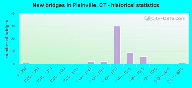
- New bridges - historical statistics
- 1Before 1900
- 21940-1949
- 21950-1959
- 301960-1969
- 91970-1979
- 61980-1989
- 12010-2019

- Reconstructed bridges - Historical Statistics
- 11920-1929
- 01930-1939
- 01940-1949
- 01950-1959
- 01960-1969
- 01970-1979
- 21980-1989
- 51990-1999
- 22000-2009


- Bridge Condition - Deck
- 33.3%Good
- 62.5%Satisfactory
- 4.2%Fair

- Bridge Condition - Superstructure
- 14.8%Good
- 40.7%Satisfactory
- 40.7%Fair
- 3.7%Poor

- Bridge Condition - Substructure
- 19.2%Good
- 73.1%Satisfactory
- 7.7%Fair

- Bridge Condition - Channel
- 25.0%Good
- 50.0%Satisfactory
- 25.0%Fair

- Bridge Condition - Culverts
- 50.0%Good
- 33.3%Satisfactory
- 16.7%Poor
Find on map >> Show street view
Structure Number: 65, Location: BETWEEN EXIT 17 AND 18 (Lat: 41.121567, Lng: -73.361258), Route carried "on" structure: Interstate 95, Year Built: 1957, Year Reconstructed: 1996, Status: Open, Structure Length: 2.83m (9.28ft), Average Daily Traffic: 121,600 (year 2017), Truck Traffic: 9%, Average Future Daily Traffic: 180,685 (year 2037), Design Load: H 20, Features Intersected: COMPO ROAD SOUTH
Minimum Vertical Clearance: 30+ m (98+ ft), Kilometerpoint: 30.240, Lanes on structure: 6, Lanes under structure: 2, Base Highway Network: Yes, Owner: State Highway Agency, Approaching Roadway Width: 36.0m (118.1ft), Skew: 30 degrees, Material/Design: Steel, Design/Construction: Stringer/Multi-beam, Number Of Spans In Main Unit: 1, Length of Maximum Span: 26.8m (87.9ft), Curb-To-Curb Width: 36.0m (118.1ft), Out-to-Out Width: 38.9m (127.6ft)
Condition: Deck: Satisfactory, Superstructure: Fair, Substructure: Satisfactory, Operating Rating: 84.9 metric tons, Method Used To Determine Operating Rating: Load Factor (LF), Inventory Rating: 51.0 metric tons, Method Used To Determine Inventory Rating: Load Factor (LF), Structural Evaluation: Somewhat better than minimum adequacy, Deck Geometry: Superior to present desirable criteria, Underclear: Somewhat better than minimum adequacy, Approach Roadway Alignment: Equal to present desirable criteria, Designated Inspection Frequency: Every 24 months, Inspection Date: May 2021, Deck Structure Type: Concrete Cast-file-Place, Wearing Surface/Protective System: Wearing Surface: Bituminous, Membrane: Built-up, Deck Protection: Epoxy Coated Reinforcing
Find on map >> Show street view
Structure Number: 317, Location: 200 FT NORTH OF DARIEN TL (Lat: 41.091972, Lng: -73.453525), Route carried "on" structure: US 1, Year Built: 1850, Year Reconstructed: 1927, Status: Open, Structure Length: 1.01m (3.31ft), Average Daily Traffic: 27,100 (year 2017), Truck Traffic: 5%, Average Future Daily Traffic: 40,268 (year 2037), Features Intersected: FIVE MILE RIVER
Minimum Vertical Clearance: 30+ m (98+ ft), Kilometerpoint: 20.793, Lanes on structure: 4, Base Highway Network: Yes, Owner: State Highway Agency, Approaching Roadway Width: 17.4m (57.1ft), Skew: 1 degrees, Material/Design: Concrete, Design/Construction: Arch - Deck, Number Of Spans In Main Unit: 1, Length of Maximum Span: 10.1m (33.1ft), Curb or Sidewalk Widths: Left: 1.5m (4.9ft), Right: 0.0m, Curb-To-Curb Width: 17.4m (57.1ft), Out-to-Out Width: 19.8m (65.0ft)
Condition: Superstructure: Fair, Substructure: Fair, Channel: Fair, Operating Rating: 42.6 metric tons, Method Used To Determine Operating Rating: Field evaluation and documented engineering judgment, Inventory Rating: 32.7 metric tons, Method Used To Determine Inventory Rating: Field evaluation and documented engineering judgment, Structural Evaluation: Somewhat better than minimum adequacy, Deck Geometry: Somewhat better than minimum adequacy, Waterway Adequacy: Somewhat better than minimum adequacy, Approach Roadway Alignment: Equal to present desirable criteria, Designated Inspection Frequency: Every 24 months, Inspection Date: November 2021
Find on map >> Show street view
Structure Number: 331, Location: 0.1 MI S OF ROUTE 10 (Lat: 41.297303, Lng: -72.950775), Route carried "on" structure: US 1, Year Built: 1950, Year Reconstructed: 1990, Status: Open, Structure Length: 3.12m (10.24ft), Average Daily Traffic: 20,500 (year 2015), Truck Traffic: 6%, Average Future Daily Traffic: 30,461 (year 2035), Design Load: HS 20, Features Intersected: WEST RIVER
Minimum Vertical Clearance: 30+ m (98+ ft), Kilometerpoint: 74.883, Lanes on structure: 4, Base Highway Network: Yes, Owner: State Highway Agency, Approaching Roadway Width: 15.2m (49.9ft), Skew: 3 degrees, Material/Design: Steel, Design/Construction: Stringer/Multi-beam, Number Of Spans In Main Unit: 2, Length of Maximum Span: 14.7m (48.2ft), Curb or Sidewalk Widths: Left: 1.9m (6.2ft), Right: 1.9m (6.2ft), Curb-To-Curb Width: 15.2m (49.9ft), Out-to-Out Width: 19.8m (65.0ft)
Condition: Deck: Good, Superstructure: Fair, Substructure: Satisfactory, Channel: Fair, Operating Rating: 71.4 metric tons, Method Used To Determine Operating Rating: Load Factor (LF), Inventory Rating: 42.8 metric tons, Method Used To Determine Inventory Rating: Load Factor (LF), Structural Evaluation: Somewhat better than minimum adequacy, Deck Geometry: High priority of corrective action, Waterway Adequacy: Equal to present minimum criteria, Approach Roadway Alignment: Equal to present desirable criteria, Designated Inspection Frequency: Every 24 months, Underwater Inspection Frequency: Every 24 months, Inspection Date: March 2020, Underwater Inspection Date: March 2020, Deck Structure Type: Concrete Cast-file-Place, Wearing Surface/Protective System: Wearing Surface: Bituminous, Membrane: Preformed Fabric, Deck Protection: Epoxy Coated Reinforcing
Find on map >> Show street view
Structure Number: 1485, Location: .39 MI SOUTH OF ROUTE 72 (Lat: 41.671789, Lng: -72.875606), Route carried "on" structure: State highway 177, Year Built: 1947, Year Reconstructed: 1993, Status: Open, Structure Length: 2.71m (8.89ft), Average Daily Traffic: 12,800 (year 2015), Truck Traffic: 4%, Average Future Daily Traffic: 19,020 (year 2035), Design Load: HS 20, Features Intersected: PEQUABUCK RIVER
Minimum Vertical Clearance: 30+ m (98+ ft), Kilometerpoint: 2.704, Lanes on structure: 2, Base Highway Network: Yes, Owner: State Highway Agency, Approaching Roadway Width: 12.2m (40.0ft), Material/Design: Steel, Design/Construction: Stringer/Multi-beam, Number Of Spans In Main Unit: 1, Length of Maximum Span: 26.2m (86.0ft), Curb or Sidewalk Widths: Left: 1.7m (5.6ft), Right: 1.7m (5.6ft), Curb-To-Curb Width: 10.2m (33.5ft), Out-to-Out Width: 14.2m (46.6ft)
Condition: Deck: Good, Superstructure: Satisfactory, Substructure: Satisfactory, Channel: Satisfactory, Operating Rating: 40.5 metric tons, Method Used To Determine Operating Rating: Load and Resistance Factor Rating (LRFR) rating reported by rating factor(RF) method using HL-93 loadings, Inventory Rating: 31.4 metric tons, Method Used To Determine Inventory Rating: Load and Resistance Factor Rating (LRFR) rating reported by rating factor(RF) method using HL-93 loadings, Structural Evaluation: Equal to present minimum criteria, Deck Geometry: Meets minimum limits, Waterway Adequacy: Equal to present desirable criteria, Approach Roadway Alignment: Equal to present minimum criteria, Designated Inspection Frequency: Every 24 months, Inspection Date: June 2021, Deck Structure Type: Concrete Cast-file-Place, Wearing Surface/Protective System: Wearing Surface: Bituminous, Membrane: Preformed Fabric, Deck Protection: Epoxy Coated Reinforcing
Find on map >> Show street view
Structure Number: 1486, Location: .4 MI SOUTH OF ROUTE 72 (Lat: 41.674897, Lng: -72.876636), Route carried "on" structure: State highway 177, Year Built: 1961, Status: Open, Structure Length: 1.04m (3.41ft), Average Daily Traffic: 12,800 (year 2015), Truck Traffic: 6%, Average Future Daily Traffic: 19,020 (year 2035), Design Load: HS 20, Features Intersected: PAN AM RAILROAD
Minimum Vertical Clearance: 30+ m (98+ ft), Kilometerpoint: 3.074, Lanes on structure: 3, Base Highway Network: Yes, Owner: State Highway Agency, Approaching Roadway Width: 13.1m (43.0ft), Skew: 2 degrees, Material/Design: Concrete, Design/Construction: Slab, Number Of Spans In Main Unit: 1, Length of Maximum Span: 9.4m (30.8ft), Curb or Sidewalk Widths: Left: 1.5m (4.9ft), Right: 1.5m (4.9ft), Curb-To-Curb Width: 12.2m (40.0ft), Out-to-Out Width: 16.0m (52.5ft)
Condition: Deck: Satisfactory, Superstructure: Satisfactory, Substructure: Satisfactory, Operating Rating: 23.0 metric tons, Method Used To Determine Operating Rating: Load and Resistance Factor Rating (LRFR) rating reported by rating factor(RF) method using HL-93 loadings, Inventory Rating: 17.8 metric tons, Method Used To Determine Inventory Rating: Load and Resistance Factor Rating (LRFR) rating reported by rating factor(RF) method using HL-93 loadings, Structural Evaluation: Meets minimum limits, Deck Geometry: Meets minimum limits, Underclear: High priority of corrective action, Approach Roadway Alignment: Equal to present desirable criteria, Bridge Posting: Required (Relationship of Operating Rating to Maximum Legal Load: 10.0 - 19.9% below), Designated Inspection Frequency: Every 24 months, Inspection Date: August 2020, Deck Structure Type: Concrete Cast-file-Place, Wearing Surface/Protective System: Wearing Surface: Bituminous, Membrane: Built-up
Find on map >> Show street view
Structure Number: 1616, Location: .4 MILE EAST OF ROUTE 10 (Lat: 41.670500, Lng: -72.852278), Route carried "on" structure: State highway 536, Year Built: 1946, Status: Open, Structure Length: 0.64m (2.10ft), Average Daily Traffic: 6,900 (year 2015), Truck Traffic: 3%, Average Future Daily Traffic: 10,253 (year 2035), Features Intersected: QUINNIPIAC RIVER
Minimum Vertical Clearance: 30+ m (98+ ft), Kilometerpoint: 0.869, Lanes on structure: 2, Owner: State Highway Agency, Approaching Roadway Width: 13.7m (44.9ft), Material/Design: Concrete continuous, Design/Construction: Culvert, Number Of Spans In Main Unit: 2, Length of Maximum Span: 3.0m (9.8ft)
Condition: Channel: Good, Culverts: Good, Operating Rating: 34.0 metric tons, Method Used To Determine Operating Rating: Load and Resistance Factor Rating (LRFR) rating reported by rating factor(RF) method using HL-93 loadings, Inventory Rating: 26.2 metric tons, Method Used To Determine Inventory Rating: Load and Resistance Factor Rating (LRFR) rating reported by rating factor(RF) method using HL-93 loadings, Structural Evaluation: Equal to present minimum criteria, Waterway Adequacy: Equal to present minimum criteria, Approach Roadway Alignment: Equal to present desirable criteria, Designated Inspection Frequency: Every 48 months, Inspection Date: May 2019
Find on map >> Show street view
Structure Number: 2214, Location: 0.2 MILE EAST OF I-84 (Lat: 41.671083, Lng: -72.839347), Route carried "on" structure: State highway 536, Year Built: 1969, Status: Open, Structure Length: 5.70m (18.70ft), Average Daily Traffic: 11,300 (year 2021), Truck Traffic: 5%, Average Future Daily Traffic: 16,791 (year 2041), Design Load: HS 20, Features Intersected: PAN AM RAILROAD
Minimum Vertical Clearance: 30+ m (98+ ft), Kilometerpoint: 2.108, Lanes on structure: 4, Owner: State Highway Agency, Approaching Roadway Width: 18.3m (60.0ft), Skew: 25 degrees, Material/Design: Steel, Design/Construction: Stringer/Multi-beam, Number Of Spans In Main Unit: 3, Length of Maximum Span: 20.1m (65.9ft), Curb or Sidewalk Widths: Left: 0.5m (1.6ft), Right: 0.5m (1.6ft), Curb-To-Curb Width: 18.3m (60.0ft), Out-to-Out Width: 23.0m (75.5ft)
Condition: Deck: Satisfactory, Superstructure: Poor, Substructure: Fair, Operating Rating: 27.2 metric tons, Method Used To Determine Operating Rating: Load and Resistance Factor Rating (LRFR) rating reported by rating factor(RF) method using HL-93 loadings, Inventory Rating: 21.1 metric tons, Method Used To Determine Inventory Rating: Load and Resistance Factor Rating (LRFR) rating reported by rating factor(RF) method using HL-93 loadings, Structural Evaluation: Meets minimum limits, Deck Geometry: Somewhat better than minimum adequacy, Underclear: Somewhat better than minimum adequacy, Approach Roadway Alignment: Equal to present minimum criteria, Designated Inspection Frequency: Every 24 months, Inspection Date: December 2021, Total Project Cost: $9,195,000, Deck Structure Type: Concrete Cast-file-Place, Wearing Surface/Protective System: Wearing Surface: Bituminous, Membrane: Built-up
Find on map >> Show street view
Structure Number: 2901, Location: 1.5 MI WEST OF I-84 (Lat: 41.676028, Lng: -72.857647), Route carried "on" structure: State highway 72, Year Built: 1975, Status: Open, Structure Length: 4.43m (14.53ft), Average Daily Traffic: 26,200 (year 2015), Truck Traffic: 8%, Average Future Daily Traffic: 38,931 (year 2035), Design Load: HS 20, Features Intersected: ROUTE 10
Minimum Vertical Clearance: 30+ m (98+ ft), Kilometerpoint: 7.596, Lanes on structure: 3, Lanes under structure: 2, Base Highway Network: Yes, Owner: State Highway Agency, Approaching Roadway Width: 17.4m (57.1ft), Material/Design: Steel, Design/Construction: Box Beam or Girders - Single/Spread, Number Of Spans In Main Unit: 1, Length of Maximum Span: 42.9m (140.7ft), Curb-To-Curb Width: 26.2m (86.0ft), Out-to-Out Width: 27.4m (89.9ft)
Condition: Deck: Good, Superstructure: Good, Substructure: Good, Operating Rating: 60.3 metric tons, Method Used To Determine Operating Rating: Load and Resistance Factor Rating (LRFR) rating reported by rating factor(RF) method using HL-93 loadings, Inventory Rating: 46.3 metric tons, Method Used To Determine Inventory Rating: Load and Resistance Factor Rating (LRFR) rating reported by rating factor(RF) method using HL-93 loadings, Structural Evaluation: Better than present minimum criteria, Deck Geometry: Superior to present desirable criteria, Underclear: Better than present minimum criteria, Approach Roadway Alignment: Equal to present desirable criteria, Designated Inspection Frequency: Every 24 months, Inspection Date: April 2020, Deck Structure Type: Concrete Cast-file-Place, Wearing Surface/Protective System: Wearing Surface: Bituminous, Membrane: Preformed Fabric
Find on map >> Show street view
Structure Number: 2902, Location: 1.5 MI W OF INTERSTATE-84 (Lat: 41.676406, Lng: -72.857458), Route carried "on" structure: State highway 72, Year Built: 1975, Status: Open, Structure Length: 4.42m (14.50ft), Average Daily Traffic: 26,900 (year 2015), Truck Traffic: 8%, Average Future Daily Traffic: 39,971 (year 2035), Design Load: HS 20, Features Intersected: ROUTE 10
Minimum Vertical Clearance: 30+ m (98+ ft), Kilometerpoint: 7.596, Lanes on structure: 3, Lanes under structure: 2, Base Highway Network: Yes, Owner: State Highway Agency, Approaching Roadway Width: 17.4m (57.1ft), Material/Design: Steel, Design/Construction: Box Beam or Girders - Single/Spread, Number Of Spans In Main Unit: 1, Length of Maximum Span: 43.0m (141.1ft), Curb-To-Curb Width: 26.2m (86.0ft), Out-to-Out Width: 27.4m (89.9ft)
Condition: Deck: Satisfactory, Superstructure: Good, Substructure: Good, Operating Rating: 58.3 metric tons, Method Used To Determine Operating Rating: Load and Resistance Factor Rating (LRFR) rating reported by rating factor(RF) method using HL-93 loadings, Inventory Rating: 45.0 metric tons, Method Used To Determine Inventory Rating: Load and Resistance Factor Rating (LRFR) rating reported by rating factor(RF) method using HL-93 loadings, Structural Evaluation: Better than present minimum criteria, Deck Geometry: Superior to present desirable criteria, Underclear: Better than present minimum criteria, Approach Roadway Alignment: Equal to present desirable criteria, Designated Inspection Frequency: Every 24 months, Inspection Date: April 2020, Deck Structure Type: Concrete Cast-file-Place, Wearing Surface/Protective System: Wearing Surface: Bituminous, Membrane: Preformed Fabric
Find on map >> Show street view
Structure Number: 2904, Location: 0.5 MI W OF I-84 INTRCHNG (Lat: 41.675494, Lng: -72.855164), Route carried "on" structure: State highway 72, Year Built: 1975, Status: Open, Structure Length: 5.94m (19.49ft), Average Daily Traffic: 26,200 (year 2015), Truck Traffic: 8%, Average Future Daily Traffic: 38,931 (year 2035), Design Load: HS 20, Features Intersected: ROUTE 372
Minimum Vertical Clearance: 30+ m (98+ ft), Kilometerpoint: 7.339, Lanes on structure: 3, Lanes under structure: 6, Base Highway Network: Yes, Owner: State Highway Agency, Approaching Roadway Width: 15.2m (49.9ft), Skew: 5 degrees, Material/Design: Steel, Design/Construction: Box Beam or Girders - Single/Spread, Number Of Spans In Main Unit: 1, Length of Maximum Span: 56.7m (186.0ft), Curb-To-Curb Width: 26.2m (86.0ft), Out-to-Out Width: 27.4m (89.9ft)
Condition: Deck: Satisfactory, Superstructure: Good, Substructure: Good, Operating Rating: 72.6 metric tons, Method Used To Determine Operating Rating: Load Factor (LF), Inventory Rating: 43.5 metric tons, Method Used To Determine Inventory Rating: Load Factor (LF), Structural Evaluation: Better than present minimum criteria, Deck Geometry: Superior to present desirable criteria, Underclear: Meets minimum limits, Approach Roadway Alignment: Equal to present desirable criteria, Designated Inspection Frequency: Every 24 months, Inspection Date: April 2020, Deck Structure Type: Concrete Cast-file-Place, Wearing Surface/Protective System: Wearing Surface: Bituminous, Membrane: Built-up
Find on map >> Show street view
Structure Number: 2908, Location: 0.2 MILES EAST ROUTE 10 (Lat: 41.675728, Lng: -72.854386), Route carried "on" structure: State highway 72, Year Built: 1975, Status: Open, Structure Length: 5.94m (19.49ft), Average Daily Traffic: 26,200 (year 2015), Truck Traffic: 8%, Average Future Daily Traffic: 38,931 (year 2035), Design Load: HS 20, Features Intersected: ROUTE 372
Minimum Vertical Clearance: 30+ m (98+ ft), Kilometerpoint: 7.306, Lanes on structure: 3, Lanes under structure: 6, Base Highway Network: Yes, Owner: State Highway Agency, Approaching Roadway Width: 15.2m (49.9ft), Skew: 5 degrees, Material/Design: Steel, Design/Construction: Box Beam or Girders - Single/Spread, Number Of Spans In Main Unit: 1, Length of Maximum Span: 56.7m (186.0ft), Curb-To-Curb Width: 26.2m (86.0ft), Out-to-Out Width: 27.4m (89.9ft)
Condition: Deck: Fair, Superstructure: Satisfactory, Substructure: Good, Operating Rating: 77.1 metric tons, Method Used To Determine Operating Rating: Load Factor (LF), Inventory Rating: 46.3 metric tons, Method Used To Determine Inventory Rating: Load Factor (LF), Structural Evaluation: Equal to present minimum criteria, Deck Geometry: Superior to present desirable criteria, Underclear: Meets minimum limits, Approach Roadway Alignment: Equal to present desirable criteria, Designated Inspection Frequency: Every 24 months, Inspection Date: April 2020, Deck Structure Type: Concrete Cast-file-Place, Wearing Surface/Protective System: Wearing Surface: Bituminous, Membrane: Built-up
Find on map >> Show street view
Structure Number: 2911, Location: .1 MILE N I-84 INTERSECT (Lat: 41.672000, Lng: -72.844614), Route carried "on" structure: State highway 72, Year Built: 1975, Status: Open, Structure Length: 1.34m (4.40ft), Average Daily Traffic: 70,300 (year 2019), Truck Traffic: 6%, Average Future Daily Traffic: 104,459 (year 2039), Design Load: HS 20, Features Intersected: PAN AM RAILROAD
Minimum Vertical Clearance: 30+ m (98+ ft), Kilometerpoint: 6.421, Lanes on structure: 9, Owner: State Highway Agency, Approaching Roadway Width: 35.7m (117.1ft), Skew: 20 degrees, Material/Design: Prestressed concrete, Design/Construction: Arch - Deck, Number Of Spans In Main Unit: 1, Length of Maximum Span: 13.1m (43.0ft), Curb-To-Curb Width: 83.2m (273.0ft), Out-to-Out Width: 173.4m (568.9ft)
Condition: Superstructure: Satisfactory, Structural Evaluation: Equal to present minimum criteria, Deck Geometry: Superior to present desirable criteria, Underclear: Meets minimum limits, Approach Roadway Alignment: Equal to present desirable criteria, Designated Inspection Frequency: Every 24 months, Inspection Date: December 2021
Find on map >> Show street view
Structure Number: 317, Location: .6 MI E OF SOUTHINGTON TL (Lat: 41.660325, Lng: -72.848919), Route carried "on" structure: Interstate 84, Year Built: 1965, Status: Open, Structure Length: 2.87m (9.42ft), Average Daily Traffic: 47,200 (year 2018), Truck Traffic: 9%, Average Future Daily Traffic: 70,134 (year 2038), Design Load: HS 20, Features Intersected: SUNSET AVENUE #1
Minimum Vertical Clearance: 30+ m (98+ ft), Kilometerpoint: 78.214, Lanes on structure: 3, Lanes under structure: 2, Base Highway Network: Yes, Owner: State Highway Agency, Approaching Roadway Width: 15.2m (49.9ft), Skew: 12 degrees, Material/Design: Steel, Design/Construction: Stringer/Multi-beam, Number Of Spans In Main Unit: 1, Length of Maximum Span: 25.9m (85.0ft), Curb-To-Curb Width: 15.9m (52.2ft), Out-to-Out Width: 16.9m (55.4ft)
Condition: Deck: Good, Superstructure: Satisfactory, Substructure: Satisfactory, Inventory Rating: 60.8 metric tons, Method Used To Determine Inventory Rating: Load Factor (LF), Structural Evaluation: Equal to present minimum criteria, Deck Geometry: Somewhat better than minimum adequacy, Underclear: Meets minimum limits, Approach Roadway Alignment: Equal to present desirable criteria, Designated Inspection Frequency: Every 24 months, Inspection Date: September 2021, Deck Structure Type: Concrete Cast-file-Place, Wearing Surface/Protective System: Wearing Surface: Bituminous, Membrane: Built-up
Find on map >> Show street view
Structure Number: 3171, Location: .6 MI E OF SOUTHINGTON TL (Lat: 41.660681, Lng: -72.849247), Route carried "on" structure: Interstate 84, Year Built: 1965, Status: Open, Structure Length: 2.87m (9.42ft), Average Daily Traffic: 47,300 (year 2018), Truck Traffic: 9%, Average Future Daily Traffic: 70,283 (year 2038), Design Load: HS 20, Features Intersected: SUNSET AVENUE #1
Minimum Vertical Clearance: 30+ m (98+ ft), Kilometerpoint: 78.230, Lanes on structure: 3, Lanes under structure: 2, Base Highway Network: Yes, Owner: State Highway Agency, Approaching Roadway Width: 15.2m (49.9ft), Skew: 12 degrees, Material/Design: Steel, Design/Construction: Stringer/Multi-beam, Number Of Spans In Main Unit: 1, Length of Maximum Span: 25.9m (85.0ft), Curb-To-Curb Width: 15.9m (52.2ft), Out-to-Out Width: 16.9m (55.4ft)
Condition: Deck: Satisfactory, Superstructure: Satisfactory, Substructure: Satisfactory, Operating Rating: 64.8 metric tons, Method Used To Determine Operating Rating: Load and Resistance Factor Rating (LRFR) rating reported by rating factor(RF) method using HL-93 loadings, Inventory Rating: 50.2 metric tons, Method Used To Determine Inventory Rating: Load and Resistance Factor Rating (LRFR) rating reported by rating factor(RF) method using HL-93 loadings, Structural Evaluation: Equal to present minimum criteria, Deck Geometry: Somewhat better than minimum adequacy, Underclear: Meets minimum limits, Approach Roadway Alignment: Equal to present desirable criteria, Designated Inspection Frequency: Every 24 months, Inspection Date: September 2021, Deck Structure Type: Concrete Cast-file-Place, Wearing Surface/Protective System: Wearing Surface: Bituminous, Membrane: Built-up
Find on map >> Show street view
Structure Number: 3307, Location: 1.13 MI W NEW BRITAIN TL (Lat: 41.668675, Lng: -72.845150), Route carried "on" structure: Interstate 84, Year Built: 1969, Status: Open, Structure Length: 4.57m (14.99ft), Average Daily Traffic: 41,100 (year 2018), Truck Traffic: 9%, Average Future Daily Traffic: 61,070 (year 2038), Design Load: HS 20, Features Intersected: SR 536 (WOODFORD AVENUE)
Minimum Vertical Clearance: 30+ m (98+ ft), Kilometerpoint: 79.164, Lanes on structure: 3, Lanes under structure: 2, Base Highway Network: Yes, Owner: State Highway Agency, Approaching Roadway Width: 14.6m (47.9ft), Skew: 13 degrees, Material/Design: Steel, Design/Construction: Stringer/Multi-beam, Number Of Spans In Main Unit: 3, Length of Maximum Span: 23.2m (76.1ft), Curb-To-Curb Width: 15.2m (49.9ft), Out-to-Out Width: 16.8m (55.1ft)
Condition: Deck: Satisfactory, Superstructure: Fair, Substructure: Satisfactory, Operating Rating: 36.3 metric tons, Method Used To Determine Operating Rating: Load and Resistance Factor Rating (LRFR) rating reported by rating factor(RF) method using HL-93 loadings, Inventory Rating: 27.9 metric tons, Method Used To Determine Inventory Rating: Load and Resistance Factor Rating (LRFR) rating reported by rating factor(RF) method using HL-93 loadings, Structural Evaluation: Somewhat better than minimum adequacy, Deck Geometry: Meets minimum limits, Underclear: Equal to present minimum criteria, Approach Roadway Alignment: Better than present minimum criteria, Designated Inspection Frequency: Every 24 months, Inspection Date: Febuary 2020, Deck Structure Type: Concrete Cast-file-Place, Wearing Surface/Protective System: Wearing Surface: Bituminous, Membrane: Built-up
Find on map >> Show street view
Structure Number: 3308, Location: AT EX 34 CROOKED ST (Lat: 41.668622, Lng: -72.844228), Route carried "on" structure: Interstate 84, Year Built: 1969, Year Reconstructed: 2000, Status: Open, Structure Length: 6.31m (20.70ft), Average Daily Traffic: 41,100 (year 2018), Truck Traffic: 9%, Average Future Daily Traffic: 61,070 (year 2038), Design Load: HS 20, Features Intersected: SR 536 (WOODFORD AVENUE)
Minimum Vertical Clearance: 30+ m (98+ ft), Kilometerpoint: 79.212, Lanes on structure: 4, Lanes under structure: 2, Base Highway Network: Yes, Owner: State Highway Agency, Approaching Roadway Width: 20.4m (66.9ft), Skew: 5 degrees, Material/Design: Steel, Design/Construction: Stringer/Multi-beam, Number Of Spans In Main Unit: 3, Length of Maximum Span: 28.3m (92.8ft), Curb-To-Curb Width: 20.3m (66.6ft), Out-to-Out Width: 21.4m (70.2ft)
Condition: Deck: Satisfactory, Superstructure: Satisfactory, Substructure: Satisfactory, Operating Rating: 68.0 metric tons, Method Used To Determine Operating Rating: Load Factor (LF), Inventory Rating: 40.8 metric tons, Method Used To Determine Inventory Rating: Load Factor (LF), Structural Evaluation: Equal to present minimum criteria, Deck Geometry: Equal to present minimum criteria, Underclear: Equal to present minimum criteria, Approach Roadway Alignment: Better than present minimum criteria, Designated Inspection Frequency: Every 24 months, Inspection Date: July 2021, Deck Structure Type: Concrete Cast-file-Place, Wearing Surface/Protective System: Wearing Surface: Bituminous, Membrane: Built-up
Find on map >> Show street view
Structure Number: 3309, Location: 1/4MI WEST EXIT 33 I-84WB (Lat: 41.670197, Lng: -72.842700), Route carried "on" structure: Interstate 84, Year Built: 1968, Year Reconstructed: 2004, Status: Open, Structure Length: 5.10m (16.73ft), Average Daily Traffic: 38,700 (year 2018), Truck Traffic: 9%, Average Future Daily Traffic: 57,504 (year 2038), Design Load: HS 20, Features Intersected: ROUTE 72 SOUTHBOUND
Minimum Vertical Clearance: 30+ m (98+ ft), Kilometerpoint: 79.405, Lanes on structure: 3, Lanes under structure: 2, Base Highway Network: Yes, Owner: State Highway Agency, Approaching Roadway Width: 14.9m (48.9ft), Skew: 4 degrees, Material/Design: Steel, Design/Construction: Stringer/Multi-beam, Number Of Spans In Main Unit: 2, Length of Maximum Span: 35.6m (116.8ft), Curb or Sidewalk Widths: Left: 0.2m (0.7ft), Right: 0.2m (0.7ft), Curb-To-Curb Width: 15.0m (49.2ft), Out-to-Out Width: 16.1m (52.8ft)
Condition: Deck: Satisfactory, Superstructure: Fair, Substructure: Satisfactory, Operating Rating: 86.1 metric tons, Method Used To Determine Operating Rating: Load Factor (LF), Inventory Rating: 51.7 metric tons, Method Used To Determine Inventory Rating: Load Factor (LF), Structural Evaluation: Somewhat better than minimum adequacy, Deck Geometry: Meets minimum limits, Underclear: Somewhat better than minimum adequacy, Approach Roadway Alignment: Equal to present desirable criteria, Designated Inspection Frequency: Every 24 months, Inspection Date: September 2021, Deck Structure Type: Concrete Cast-file-Place, Wearing Surface/Protective System: Wearing Surface: Bituminous, Membrane: Preformed Fabric
Find on map >> Show street view
Structure Number: 331, Location: 0.3 MI W OF ROUTE 372 (Lat: 41.670192, Lng: -72.840925), Route carried "on" structure: State highway 536, Year Built: 1968, Year Reconstructed: 1996, Status: Open, Structure Length: 14.51m (47.60ft), Average Daily Traffic: 11,000 (year 2018), Truck Traffic: 10%, Average Future Daily Traffic: 16,345 (year 2038), Design Load: HS 20, Features Intersected: INTERSTATE-84 & ROUTE 72
Minimum Vertical Clearance: 30+ m (98+ ft), Kilometerpoint: 1.915, Lanes on structure: 4, Lanes under structure: 11, Owner: State Highway Agency, Approaching Roadway Width: 21.9m (71.9ft), Skew: 9 degrees, Material/Design: Steel continuous, Design/Construction: Stringer/Multi-beam, Number Of Spans In Main Unit: 3, Number Of Approach Spans: 1, Length of Maximum Span: 50.3m (165.0ft), Curb-To-Curb Width: 21.9m (71.9ft), Out-to-Out Width: 23.0m (75.5ft)
Condition: Deck: Satisfactory, Superstructure: Satisfactory, Substructure: Satisfactory, Operating Rating: 49.9 metric tons, Method Used To Determine Operating Rating: Load Factor (LF), Inventory Rating: 29.9 metric tons, Method Used To Determine Inventory Rating: Load Factor (LF), Structural Evaluation: Equal to present minimum criteria, Deck Geometry: Superior to present desirable criteria, Underclear: Meets minimum limits, Approach Roadway Alignment: Equal to present minimum criteria, Designated Inspection Frequency: Every 24 months, Inspection Date: December 2020, Deck Structure Type: Concrete Cast-file-Place, Wearing Surface/Protective System: Wearing Surface: Latex Concrete
Find on map >> Show street view
Structure Number: 3311, Location: I-84/RT 72 INTERCHANGE 11 (Lat: 41.669061, Lng: -72.825939), Route carried "on" structure: Interstate 84, Year Built: 1969, Status: Open, Structure Length: 20.21m (66.31ft), Average Daily Traffic: 41,350 (year 2018), Truck Traffic: 9%, Average Future Daily Traffic: 61,442 (year 2038), Design Load: HS 20, Features Intersected: RT 72 NB, RR & RT 372
Minimum Vertical Clearance: 30+ m (98+ ft), Kilometerpoint: 80.805, Lanes on structure: 3, Lanes under structure: 4, Base Highway Network: Yes, Owner: State Highway Agency, Approaching Roadway Width: 15.5m (50.9ft), Skew: 10 degrees, Material/Design: Steel, Design/Construction: Stringer/Multi-beam, Number Of Spans In Main Unit: 6, Length of Maximum Span: 33.2m (108.9ft), Curb or Sidewalk Widths: Left: 0.0m, Right: 0.2m (0.7ft), Curb-To-Curb Width: 15.8m (51.8ft), Out-to-Out Width: 16.9m (55.4ft)
Condition: Deck: Satisfactory, Superstructure: Fair, Substructure: Satisfactory, Operating Rating: 44.1 metric tons, Method Used To Determine Operating Rating: Load and Resistance Factor Rating (LRFR) rating reported by rating factor(RF) method using HL-93 loadings, Inventory Rating: 34.0 metric tons, Method Used To Determine Inventory Rating: Load and Resistance Factor Rating (LRFR) rating reported by rating factor(RF) method using HL-93 loadings, Structural Evaluation: Somewhat better than minimum adequacy, Deck Geometry: Somewhat better than minimum adequacy, Underclear: Somewhat better than minimum adequacy, Approach Roadway Alignment: Somewhat better than minimum adequacy, Designated Inspection Frequency: Every 24 months, Critical Feature Inspection Frequency: Every 24 months, Inspection Date: Febuary 2020, Critical Feature Inspection Date: Febuary 2020, Deck Structure Type: Concrete Cast-file-Place, Wearing Surface/Protective System: Wearing Surface: Bituminous, Membrane: Preformed Fabric
Find on map >> Show street view
Structure Number: 3312, Location: I-84 EXIT 35 (Lat: 41.668494, Lng: -72.824153), Route carried "on" structure: Interstate 84, Year Built: 1969, Year Reconstructed: 1990, Status: Open, Structure Length: 26.00m (85.30ft), Average Daily Traffic: 41,350 (year 2018), Truck Traffic: 9%, Average Future Daily Traffic: 61,442 (year 2038), Design Load: HS 20, Features Intersected: RT 72, RT 372 & PanAm RR
Minimum Vertical Clearance: 30+ m (98+ ft), Kilometerpoint: 80.837, Lanes on structure: 3, Lanes under structure: 6, Base Highway Network: Yes, Owner: State Highway Agency, Approaching Roadway Width: 15.5m (50.9ft), Material/Design: Steel, Design/Construction: Stringer/Multi-beam, Number Of Spans In Main Unit: 8, Length of Maximum Span: 32.9m (107.9ft), Curb or Sidewalk Widths: Left: 0.5m (1.6ft), Right: 0.2m (0.7ft), Curb-To-Curb Width: 15.5m (50.9ft), Out-to-Out Width: 16.9m (55.4ft)
Condition: Deck: Satisfactory, Superstructure: Fair, Substructure: Satisfactory, Channel: Good, Operating Rating: 40.8 metric tons, Method Used To Determine Operating Rating: Load and Resistance Factor Rating (LRFR) rating reported by rating factor(RF) method using HL-93 loadings, Inventory Rating: 31.4 metric tons, Method Used To Determine Inventory Rating: Load and Resistance Factor Rating (LRFR) rating reported by rating factor(RF) method using HL-93 loadings, Structural Evaluation: Somewhat better than minimum adequacy, Deck Geometry: Somewhat better than minimum adequacy, Underclear: Somewhat better than minimum adequacy, Waterway Adequacy: Superior to present desirable criteria, Approach Roadway Alignment: Equal to present minimum criteria, Designated Inspection Frequency: Every 24 months, Critical Feature Inspection Frequency: Every 24 months, Inspection Date: Febuary 2020, Critical Feature Inspection Date: Febuary 2020, Deck Structure Type: Concrete Cast-file-Place, Wearing Surface/Protective System: Wearing Surface: Bituminous, Membrane: Preformed Fabric
Find on map >> Show street view
Structure Number: 3316, Location: RTE 72 NB RAMP TO 84 WB (Lat: 41.668658, Lng: -72.845414), Route carried "on" structure: Ramp Interstate 84, Year Built: 1969, Status: Open, Structure Length: 4.11m (13.48ft), Average Daily Traffic: 20,261 (year 2020), Truck Traffic: 9%, Average Future Daily Traffic: 30,106 (year 2040), Design Load: HS 20, Features Intersected: SR 536 (WOODFORD AVENUE)
Minimum Vertical Clearance: 30+ m (98+ ft), Kilometerpoint: 0.628, Lanes on structure: 1, Lanes under structure: 3, Owner: State Highway Agency, Approaching Roadway Width: 12.2m (40.0ft), Skew: 2 degrees, Material/Design: Steel, Design/Construction: Stringer/Multi-beam, Number Of Spans In Main Unit: 3, Length of Maximum Span: 19.8m (65.0ft), Curb-To-Curb Width: 12.2m (40.0ft), Out-to-Out Width: 13.3m (43.6ft)
Condition: Deck: Good, Superstructure: Fair, Substructure: Satisfactory, Operating Rating: 32.1 metric tons, Method Used To Determine Operating Rating: Load and Resistance Factor Rating (LRFR) rating reported by rating factor(RF) method using HL-93 loadings, Inventory Rating: 24.6 metric tons, Method Used To Determine Inventory Rating: Load and Resistance Factor Rating (LRFR) rating reported by rating factor(RF) method using HL-93 loadings, Structural Evaluation: Somewhat better than minimum adequacy, Deck Geometry: Superior to present desirable criteria, Underclear: Equal to present minimum criteria, Approach Roadway Alignment: Equal to present desirable criteria, Designated Inspection Frequency: Every 24 months, Inspection Date: Febuary 2020, Deck Structure Type: Concrete Cast-file-Place, Wearing Surface/Protective System: Wearing Surface: Bituminous, Membrane: Built-up
Find on map >> Show street view
Structure Number: 3317, Location: I-84 EB EXIT 33 TO RT72WB (Lat: 41.669058, Lng: -72.844483), Route carried "on" structure: Ramp Interstate 84, Year Built: 1969, Year Reconstructed: 1991, Status: Open, Structure Length: 15.48m (50.79ft), Average Daily Traffic: 7,650 (year 2020), Truck Traffic: 9%, Average Future Daily Traffic: 11,367 (year 2040), Design Load: HS 20, Features Intersected: I-84 WB & SR 536
Minimum Vertical Clearance: 30+ m (98+ ft), Kilometerpoint: 0.370, Lanes on structure: 1, Lanes under structure: 5, Owner: State Highway Agency, Approaching Roadway Width: 9.1m (29.9ft), Skew: 9 degrees, Material/Design: Steel continuous, Design/Construction: Stringer/Multi-beam, Number Of Spans In Main Unit: 3, Length of Maximum Span: 53.3m (174.9ft), Curb-To-Curb Width: 9.8m (32.2ft), Out-to-Out Width: 10.8m (35.4ft)
Condition: Deck: Satisfactory, Superstructure: Fair, Substructure: Satisfactory, Operating Rating: 64.3 metric tons, Method Used To Determine Operating Rating: Load Factor (LF), Inventory Rating: 38.5 metric tons, Method Used To Determine Inventory Rating: Load Factor (LF), Structural Evaluation: Somewhat better than minimum adequacy, Deck Geometry: Superior to present desirable criteria, Underclear: Somewhat better than minimum adequacy, Approach Roadway Alignment: Better than present minimum criteria, Designated Inspection Frequency: Every 24 months, Inspection Date: Febuary 2020, Deck Structure Type: Concrete Cast-file-Place, Wearing Surface/Protective System: Wearing Surface: Bituminous, Membrane: Built-up
Find on map >> Show street view
Structure Number: 3318, Location: INTERSTATE-84 EB EXIT 33 (Lat: 41.670792, Lng: -72.843931), Route carried "on" structure: Ramp Interstate 84, Year Built: 1969, Status: Open, Structure Length: 8.08m (26.51ft), Average Daily Traffic: 3,600 (year 2018), Truck Traffic: 9%, Average Future Daily Traffic: 5,349 (year 2038), Design Load: HS 20, Features Intersected: ROUTE 72 SOUTHBOUND
Minimum Vertical Clearance: 30+ m (98+ ft), Kilometerpoint: 0.724, Lanes on structure: 1, Lanes under structure: 2, Owner: State Highway Agency, Approaching Roadway Width: 9.8m (32.2ft), Skew: 4 degrees, Material/Design: Steel, Design/Construction: Stringer/Multi-beam, Number Of Spans In Main Unit: 3, Length of Maximum Span: 29.6m (97.1ft), Curb or Sidewalk Widths: Left: 0.2m (0.7ft), Right: 0.2m (0.7ft), Curb-To-Curb Width: 9.8m (32.2ft), Out-to-Out Width: 10.8m (35.4ft)
Condition: Deck: Good, Superstructure: Fair, Substructure: Satisfactory, Inventory Rating: 61.9 metric tons, Method Used To Determine Inventory Rating: Load Factor (LF), Structural Evaluation: Somewhat better than minimum adequacy, Deck Geometry: Superior to present desirable criteria, Underclear: Equal to present minimum criteria, Approach Roadway Alignment: Equal to present minimum criteria, Designated Inspection Frequency: Every 24 months, Inspection Date: September 2021, Deck Structure Type: Concrete Cast-file-Place, Wearing Surface/Protective System: Wearing Surface: Bituminous, Membrane: Built-up
Find on map >> Show street view
Structure Number: 3319, Location: 1.80 MILE SOUTH ROUTE 177 (Lat: 41.671553, Lng: -72.844264), Route carried "on" structure: State highway 72, Year Built: 1969, Status: Open, Structure Length: 0.73m (2.40ft), Average Daily Traffic: 68,500 (year 2018), Truck Traffic: 5%, Average Future Daily Traffic: 101,784 (year 2038), Features Intersected: QUINNIPIAC RIVER
Minimum Vertical Clearance: 30+ m (98+ ft), Kilometerpoint: 6.405, Lanes on structure: 8, Base Highway Network: Yes, Owner: State Highway Agency, Approaching Roadway Width: 40.2m (131.9ft), Skew: 29 degrees, Material/Design: Concrete continuous, Design/Construction: Culvert, Number Of Spans In Main Unit: 2, Length of Maximum Span: 3.0m (9.8ft)
Condition: Channel: Satisfactory, Culverts: Satisfactory, Structural Evaluation: Equal to present minimum criteria, Waterway Adequacy: Equal to present desirable criteria, Approach Roadway Alignment: Equal to present desirable criteria, Designated Inspection Frequency: Every 24 months, Inspection Date: May 2021
Find on map >> Show street view
Structure Number: 4312, Location: 0.1 MILE E OF EXPWY END (Lat: 41.674111, Lng: -72.882764), Route carried "on" structure: State highway 72, Year Built: 1980, Status: Open, Structure Length: 7.53m (24.70ft), Average Daily Traffic: 54,800 (year 2019), Truck Traffic: 8%, Average Future Daily Traffic: 81,427 (year 2039), Design Load: HS 20, Features Intersected: PEQUABUCK RIVER
Minimum Vertical Clearance: 30+ m (98+ ft), Kilometerpoint: 9.865, Lanes on structure: 4, Base Highway Network: Yes, Owner: State Highway Agency, Approaching Roadway Width: 16.5m (54.1ft), Skew: 30 degrees, Material/Design: Steel continuous, Design/Construction: Stringer/Multi-beam, Number Of Spans In Main Unit: 2, Length of Maximum Span: 37.5m (123.0ft), Curb-To-Curb Width: 16.5m (54.1ft), Out-to-Out Width: 18.2m (59.7ft)
Condition: Deck: Good, Superstructure: Satisfactory, Substructure: Satisfactory, Channel: Satisfactory, Operating Rating: 35.6 metric tons, Method Used To Determine Operating Rating: Load and Resistance Factor Rating (LRFR) rating reported by rating factor(RF) method using HL-93 loadings, Inventory Rating: 27.2 metric tons, Method Used To Determine Inventory Rating: Load and Resistance Factor Rating (LRFR) rating reported by rating factor(RF) method using HL-93 loadings, Structural Evaluation: Equal to present minimum criteria, Deck Geometry: Meets minimum limits, Waterway Adequacy: Superior to present desirable criteria, Approach Roadway Alignment: Equal to present desirable criteria, Designated Inspection Frequency: Every 24 months, Inspection Date: November 2021, Deck Structure Type: Concrete Cast-file-Place, Wearing Surface/Protective System: Wearing Surface: Bituminous, Membrane: Built-up
Find on map >> Show street view
Structure Number: 4313, Location: 0.25 MI. NORTH OF RTE 177 (Lat: 41.675367, Lng: -72.880833), Route carried "on" structure: State highway 72, Year Built: 1980, Status: Open, Structure Length: 1.63m (5.35ft), Average Daily Traffic: 28,800 (year 2015), Truck Traffic: 6%, Average Future Daily Traffic: 42,794 (year 2035), Design Load: HS 20, Features Intersected: PAN AM RAILROAD
Minimum Vertical Clearance: 30+ m (98+ ft), Kilometerpoint: 9.688, Lanes on structure: 4, Base Highway Network: Yes, Owner: State Highway Agency, Approaching Roadway Width: 16.5m (54.1ft), Skew: 34 degrees, Material/Design: Concrete, Design/Construction: Frame, Number Of Spans In Main Unit: 1, Length of Maximum Span: 10.4m (34.1ft), Curb-To-Curb Width: 16.5m (54.1ft), Out-to-Out Width: 18.2m (59.7ft)
Condition: Superstructure: Fair, Substructure: Satisfactory, Operating Rating: 82.4 metric tons, Method Used To Determine Operating Rating: Load Factor (LF), Inventory Rating: 49.3 metric tons, Method Used To Determine Inventory Rating: Load Factor (LF), Structural Evaluation: Somewhat better than minimum adequacy, Deck Geometry: High priority of replacement, Underclear: Equal to present minimum criteria, Approach Roadway Alignment: Equal to present desirable criteria, Designated Inspection Frequency: Every 24 months, Inspection Date: March 2021, Wearing Surface/Protective System: Wearing Surface: Bituminous, Membrane: Preformed Fabric
Find on map >> Show street view
Structure Number: 4314, Location: 800 FT NORTH OF ROUTE 177 (Lat: 41.676322, Lng: -72.879364), Route carried "on" structure: State highway 72, Year Built: 1980, Status: Open, Structure Length: 3.69m (12.11ft), Average Daily Traffic: 28,400 (year 2015), Truck Traffic: 5%, Average Future Daily Traffic: 42,200 (year 2035), Design Load: HS 20, Features Intersected: CAMP STREET
Minimum Vertical Clearance: 30+ m (98+ ft), Kilometerpoint: 9.511, Lanes on structure: 4, Lanes under structure: 2, Base Highway Network: Yes, Owner: State Highway Agency, Approaching Roadway Width: 17.1m (56.1ft), Skew: 30 degrees, Material/Design: Steel continuous, Design/Construction: Stringer/Multi-beam, Number Of Spans In Main Unit: 3, Length of Maximum Span: 24.4m (80.1ft), Curb-To-Curb Width: 16.5m (54.1ft), Out-to-Out Width: 18.2m (59.7ft)
Condition: Deck: Good, Superstructure: Good, Substructure: Good, Operating Rating: 62.2 metric tons, Method Used To Determine Operating Rating: Load and Resistance Factor Rating (LRFR) rating reported by rating factor(RF) method using HL-93 loadings, Inventory Rating: 48.0 metric tons, Method Used To Determine Inventory Rating: Load and Resistance Factor Rating (LRFR) rating reported by rating factor(RF) method using HL-93 loadings, Structural Evaluation: Better than present minimum criteria, Deck Geometry: High priority of replacement, Underclear: Superior to present desirable criteria, Approach Roadway Alignment: Equal to present desirable criteria, Designated Inspection Frequency: Every 24 months, Inspection Date: July 2020, Deck Structure Type: Concrete Cast-file-Place, Wearing Surface/Protective System: Wearing Surface: Bituminous, Membrane: Built-up
Find on map >> Show street view
Structure Number: 4315, Location: AT EXIT 1 (Lat: 41.677525, Lng: -72.877108), Route carried "on" structure: State highway 72, Year Built: 1980, Status: Open, Structure Length: 4.27m (14.01ft), Average Daily Traffic: 29,700 (year 2020), Truck Traffic: 5%, Average Future Daily Traffic: 44,131 (year 2040), Design Load: HS 20, Features Intersected: ROUTE 177
Minimum Vertical Clearance: 30+ m (98+ ft), Kilometerpoint: 9.270, Lanes on structure: 4, Lanes under structure: 3, Base Highway Network: Yes, Owner: State Highway Agency, Approaching Roadway Width: 17.1m (56.1ft), Skew: 31 degrees, Material/Design: Steel continuous, Design/Construction: Stringer/Multi-beam, Number Of Spans In Main Unit: 3, Length of Maximum Span: 28.7m (94.2ft), Curb-To-Curb Width: 16.5m (54.1ft), Out-to-Out Width: 18.2m (59.7ft)
Condition: Deck: Satisfactory, Superstructure: Satisfactory, Substructure: Satisfactory, Operating Rating: 17.2 metric tons, Method Used To Determine Operating Rating: Load and Resistance Factor Rating (LRFR) rating reported by rating factor(RF) method using HL-93 loadings, Inventory Rating: 13.3 metric tons, Method Used To Determine Inventory Rating: Load and Resistance Factor Rating (LRFR) rating reported by rating factor(RF) method using HL-93 loadings, Structural Evaluation: High priority of corrective action, Deck Geometry: High priority of replacement, Underclear: Equal to present minimum criteria, Approach Roadway Alignment: Equal to present desirable criteria, Designated Inspection Frequency: Every 24 months, Inspection Date: November 2021, Deck Structure Type: Concrete Cast-file-Place, Wearing Surface/Protective System: Wearing Surface: Bituminous, Membrane: Built-up
Find on map >> Show street view
Structure Number: 4316, Location: APPR .5 MI WEST OF RTE 10 (Lat: 41.677594, Lng: -72.866261), Route carried "on" structure: State highway 72, Year Built: 1980, Status: Open, Structure Length: 23.29m (76.41ft), Average Daily Traffic: 52,400 (year 2015), Truck Traffic: 6%, Average Future Daily Traffic: 77,861 (year 2035), Design Load: HS 20, Features Intersected: CRONK RD, PAN AM,PEQ. R.
Minimum Vertical Clearance: 30+ m (98+ ft), Kilometerpoint: 8.256, Lanes on structure: 4, Lanes under structure: 2, Base Highway Network: Yes, Owner: State Highway Agency, Approaching Roadway Width: 16.5m (54.1ft), Skew: 32 degrees, Material/Design: Steel continuous, Design/Construction: Stringer/Multi-beam, Number Of Spans In Main Unit: 5, Length of Maximum Span: 61.0m (200.1ft), Curb-To-Curb Width: 16.5m (54.1ft), Out-to-Out Width: 18.2m (59.7ft)
Condition: Deck: Satisfactory, Superstructure: Satisfactory, Substructure: Satisfactory, Channel: Satisfactory, Operating Rating: 64.9 metric tons, Method Used To Determine Operating Rating: Load Factor (LF), Inventory Rating: 38.8 metric tons, Method Used To Determine Inventory Rating: Load Factor (LF), Structural Evaluation: Equal to present minimum criteria, Deck Geometry: Meets minimum limits, Underclear: Equal to present minimum criteria, Waterway Adequacy: Equal to present desirable criteria, Approach Roadway Alignment: Equal to present minimum criteria, Designated Inspection Frequency: Every 24 months, Inspection Date: July 2020, Deck Structure Type: Concrete Cast-file-Place, Wearing Surface/Protective System: Wearing Surface: Bituminous, Membrane: Preformed Fabric
Find on map >> Show street view
Structure Number: 4544, Location: 100' FROM JCT CAROL DRIVE (Lat: 41.655064, Lng: -72.865414), Route carried "on" structure: City street , Year Built: 1968, Status: Open, Structure Length: 1.28m (4.20ft), Average Daily Traffic: 3,416 (year 2020), Truck Traffic: 2%, Average Future Daily Traffic: 5,076 (year 2040), Features Intersected: QUINNIPIAC RIVER, Facility Carried by Structure: SHUTTLEMEADOW ROAD
Minimum Vertical Clearance: 30+ m (98+ ft), Kilometerpoint: 0.000, Lanes on structure: 2, Owner: Town or Township Highway Agency, Approaching Roadway Width: 7.0m (23.0ft), Skew: 1 degrees, Material/Design: Steel, Design/Construction: Culvert, Number Of Spans In Main Unit: 3, Length of Maximum Span: 3.7m (12.1ft), Curb or Sidewalk Widths: Left: 2.6m (8.5ft), Right: 1.2m (3.9ft), Curb-To-Curb Width: 10.2m (33.5ft), Out-to-Out Width: 23.9m (78.4ft)
Condition: Channel: Satisfactory, Culverts: Satisfactory, Operating Rating: 97.2 metric tons, Method Used To Determine Operating Rating: Load and Resistance Factor Rating (LRFR) rating reported by rating factor(RF) method using HL-93 loadings, Inventory Rating: 97.2 metric tons, Method Used To Determine Inventory Rating: Load and Resistance Factor Rating (LRFR) rating reported by rating factor(RF) method using HL-93 loadings, Structural Evaluation: Equal to present minimum criteria, Deck Geometry: Meets minimum limits, Waterway Adequacy: Somewhat better than minimum adequacy, Approach Roadway Alignment: Equal to present desirable criteria, Designated Inspection Frequency: Every 24 months, Underwater Inspection Frequency: Every 24 months, Inspection Date: August 2020, Underwater Inspection Date: August 2020
Find on map >> Show street view
Structure Number: 4545, Location: 0.6 MI. SOUTH OF ROUTE 10 (Lat: 41.656775, Lng: -72.859717), Route carried "on" structure: City street , Year Built: 2013, Status: Open, Structure Length: 1.19m (3.90ft), Average Daily Traffic: 1,924 (year 2018), Truck Traffic: 2%, Average Future Daily Traffic: 2,859 (year 2038), Design Load: HL 93, Features Intersected: QUINNIPIAC RIVER, Facility Carried by Structure: STILLWELL DRIVE
Minimum Vertical Clearance: 30+ m (98+ ft), Kilometerpoint: 0.000, Lanes on structure: 2, Owner: Town or Township Highway Agency, Approaching Roadway Width: 10.4m (34.1ft), Skew: 4 degrees, Material/Design: Concrete, Design/Construction: Culvert, Number Of Spans In Main Unit: 2, Length of Maximum Span: 5.5m (18.0ft), Curb or Sidewalk Widths: Left: 1.7m (5.6ft), Right: 1.7m (5.6ft), Curb-To-Curb Width: 10.4m (34.1ft), Out-to-Out Width: 21.2m (69.6ft)
Condition: Channel: Good, Culverts: Good, Operating Rating: 46.0 metric tons, Method Used To Determine Operating Rating: Load and Resistance Factor Rating (LRFR) rating reported by rating factor(RF) method using HL-93 loadings, Inventory Rating: 35.6 metric tons, Method Used To Determine Inventory Rating: Load and Resistance Factor Rating (LRFR) rating reported by rating factor(RF) method using HL-93 loadings, Structural Evaluation: Better than present minimum criteria, Deck Geometry: Equal to present minimum criteria, Waterway Adequacy: Equal to present desirable criteria, Approach Roadway Alignment: Equal to present desirable criteria, Designated Inspection Frequency: Every 48 months, Inspection Date: July 2018, Deck Structure Type: Other, Wearing Surface/Protective System: Wearing Surface: Bituminous, Membrane: Built-up, Deck Protection: Epoxy Coated Reinforcing
Find on map >> Show street view
Structure Number: 4546, Location: 600' FROM CYRENUS STREET (Lat: 41.663103, Lng: -72.853394), Route carried "on" structure: City street , Year Built: 1968, Status: Open, Structure Length: 0.76m (2.49ft), Average Daily Traffic: 2,732 (year 2020), Truck Traffic: 2%, Average Future Daily Traffic: 4,059 (year 2040), Features Intersected: QUINNIPIAC RIVER, Facility Carried by Structure: TOMLINSON AVENUE
Minimum Vertical Clearance: 30+ m (98+ ft), Kilometerpoint: 0.000, Lanes on structure: 2, Owner: Town or Township Highway Agency, Approaching Roadway Width: 8.5m (27.9ft), Skew: 1 degrees, Material/Design: Steel, Design/Construction: Culvert, Number Of Spans In Main Unit: 2, Length of Maximum Span: 3.7m (12.1ft)
Condition: Channel: Fair, Culverts: Poor, Operating Rating: 97.2 metric tons, Method Used To Determine Operating Rating: Load and Resistance Factor Rating (LRFR) rating reported by rating factor(RF) method using HL-93 loadings, Inventory Rating: 97.2 metric tons, Method Used To Determine Inventory Rating: Load and Resistance Factor Rating (LRFR) rating reported by rating factor(RF) method using HL-93 loadings, Structural Evaluation: Meets minimum limits, Waterway Adequacy: Somewhat better than minimum adequacy, Approach Roadway Alignment: Equal to present desirable criteria, Designated Inspection Frequency: Every 24 months, Inspection Date: July 2020, Total Project Cost: $1,410,000
Find on map >> Show street view
Structure Number: 65, Location: 0.2 MI W OF EAST JCT 372 (Lat: 41.671725, Lng: -72.837981), Route carried "on" structure: State highway 536, Year Built: 1969, Year Reconstructed: 2013, Status: Open, Structure Length: 0.70m (2.30ft), Average Daily Traffic: 10,400 (year 2020), Average Future Daily Traffic: 15,453 (year 2040), Features Intersected: QUINNIPIAC RIVER
Minimum Vertical Clearance: 30+ m (98+ ft), Kilometerpoint: 2.285, Lanes on structure: 2, Owner: State Highway Agency, Approaching Roadway Width: 16.2m (53.1ft), Skew: 2 degrees, Material/Design: Steel, Design/Construction: Culvert, Number Of Spans In Main Unit: 2, Length of Maximum Span: 3.0m (9.8ft)
Condition: Channel: Satisfactory, Culverts: Good, Structural Evaluation: Better than present minimum criteria, Waterway Adequacy: Equal to present minimum criteria, Approach Roadway Alignment: Equal to present desirable criteria, Designated Inspection Frequency: Every 24 months, Inspection Date: November 2021
Find on map >> Show street view
Structure Number: 2901, Location: 1.5 MI WEST OF I-84 (Lat: 41.676028, Lng: -72.857647), Route carried "under" structure: State highway 10, Year Built: 1975, Structure Length: 0. m, Average Daily Traffic: 13,800 (year 2015), Truck Traffic: 6%, Features Intersected: ROUTE 10, Facility Carried by Structure: ROUTE 72 EB
Minimum Vertical Clearance: 5.05m (16.57ft), Kilometerpoint: 48.168, Lanes on structure: 3, Lanes under structure: 2, Material/Design: Steel, Design/Construction: Box Beam or Girders - Single/Spread, Length of Maximum Span: 42.9m (140.7ft)
Find on map >> Show street view
Structure Number: 2902, Location: 1.5 MI W OF INTERSTATE-84 (Lat: 41.676406, Lng: -72.857458), Route carried "under" structure: State highway 10, Year Built: 1975, Structure Length: 0. m, Average Daily Traffic: 12,400 (year 2015), Truck Traffic: 6%, Features Intersected: ROUTE 10, Facility Carried by Structure: ROUTE 72 WB
Minimum Vertical Clearance: 5.03m (16.50ft), Kilometerpoint: 48.216, Lanes on structure: 3, Lanes under structure: 2, Material/Design: Steel, Design/Construction: Box Beam or Girders - Single/Spread, Length of Maximum Span: 43.0m (141.1ft)
Find on map >> Show street view
Structure Number: 2904, Location: 0.5 MI W OF I-84 INTRCHNG (Lat: 41.675494, Lng: -72.855164), Route carried "under" structure: State highway 372, Year Built: 1975, Structure Length: 0. m, Average Daily Traffic: 14,400 (year 2015), Truck Traffic: 6%, Features Intersected: ROUTE 372, Facility Carried by Structure: ROUTE 72 EB
Minimum Vertical Clearance: 5.18m (16.99ft), Kilometerpoint: 2.720, Lanes on structure: 3, Lanes under structure: 6, Material/Design: Steel, Design/Construction: Box Beam or Girders - Single/Spread, Length of Maximum Span: 56.7m (186.0ft)
Find on map >> Show street view
Structure Number: 2908, Location: 0.2 MILES EAST ROUTE 10 (Lat: 41.675728, Lng: -72.854386), Route carried "under" structure: State highway 372, Year Built: 1975, Structure Length: 0. m, Average Daily Traffic: 11,500 (year 2015), Truck Traffic: 6%, Features Intersected: ROUTE 372, Facility Carried by Structure: ROUTE 72 WB
Minimum Vertical Clearance: 5.33m (17.49ft), Kilometerpoint: 3.058, Lanes on structure: 3, Lanes under structure: 6, Material/Design: Steel, Design/Construction: Box Beam or Girders - Single/Spread, Length of Maximum Span: 56.7m (186.0ft)
Find on map >> Show street view
Structure Number: 3307, Location: 1.13 MI W NEW BRITAIN TL (Lat: 41.668675, Lng: -72.845150), Route carried "under" structure: State highway 536, Year Built: 1969, Structure Length: 0. m, Average Daily Traffic: 12,600 (year 2015), Truck Traffic: 5%, Features Intersected: SR 536 (WOODFORD AVENUE), Facility Carried by Structure: INTERSTATE-84 WB
Minimum Vertical Clearance: 4.62m (15.16ft), Kilometerpoint: 1.513, Lanes on structure: 3, Lanes under structure: 4, Material/Design: Steel, Design/Construction: Stringer/Multi-beam, Length of Maximum Span: 23.2m (76.1ft)
Find on map >> Show street view
Structure Number: 3308, Location: AT EX 34 CROOKED ST (Lat: 41.668622, Lng: -72.844228), Route carried "under" structure: State highway 536, Year Built: 1969, Structure Length: 0. m, Average Daily Traffic: 12,600 (year 2015), Truck Traffic: 10%, Features Intersected: SR 536 (WOODFORD AVENUE), Facility Carried by Structure: INTERSTATE-84 EB
Minimum Vertical Clearance: 5.77m (18.93ft), Kilometerpoint: 1.593, Lanes on structure: 4, Lanes under structure: 2, Material/Design: Steel, Design/Construction: Stringer/Multi-beam, Length of Maximum Span: 28.3m (92.8ft)
Find on map >> Show street view
Structure Number: 3309, Location: 1/4MI WEST EXIT 33 I-84WB (Lat: 41.670197, Lng: -72.842700), Route carried "under" structure: State highway 72, Year Built: 1968, Structure Length: 0. m, Average Daily Traffic: 26,300 (year 2019), Truck Traffic: 6%, Features Intersected: ROUTE 72 SOUTHBOUND, Facility Carried by Structure: INTERSTATE-84 WB
Minimum Vertical Clearance: 4.88m (16.01ft), Kilometerpoint: 6.148, Lanes on structure: 3, Lanes under structure: 2, Material/Design: Steel, Design/Construction: Stringer/Multi-beam, Length of Maximum Span: 35.6m (116.8ft)
Find on map >> Show street view
Structure Number: 331, Location: 0.3 MI W OF ROUTE 372 (Lat: 41.670192, Lng: -72.840925), Route carried "under" structure: Interstate 84, Year Built: 1968, Structure Length: 0. m, Average Daily Traffic: 78,000 (year 2018), Truck Traffic: 9%, Features Intersected: INTERSTATE-84 & ROUTE 72, Facility Carried by Structure: SR536 - CROOKED ST
Minimum Vertical Clearance: 6.05m (19.85ft), Kilometerpoint: 79.518, Lanes on structure: 4, Lanes under structure: 6, Material/Design: Steel continuous, Design/Construction: Stringer/Multi-beam, Length of Maximum Span: 50.3m (165.0ft)
Find on map >> Show street view
Structure Number: 331, Location: 0.3 MI W OF ROUTE 372 (Lat: 41.670192, Lng: -72.840925), Route carried "under" structure: State highway 72, Year Built: 1968, Structure Length: 0. m, Average Daily Traffic: 56,500 (year 2018), Truck Traffic: 6%, Features Intersected: INTERSTATE-84 & ROUTE 72, Facility Carried by Structure: SR536 - CROOKED ST
Minimum Vertical Clearance: 6.12m (20.08ft), Kilometerpoint: 6.019, Lanes on structure: 4, Lanes under structure: 5, Material/Design: Steel continuous, Design/Construction: Stringer/Multi-beam, Length of Maximum Span: 50.3m (165.0ft)
Find on map >> Show street view
Structure Number: 3311, Location: I-84/RT 72 INTERCHANGE 11 (Lat: 41.669061, Lng: -72.825939), Route carried "under" structure: State highway 72, Year Built: 1969, Structure Length: 0. m, Average Daily Traffic: 26,400 (year 2018), Truck Traffic: 6%, Features Intersected: RT 72 NB, RR & RT 372, Facility Carried by Structure: INTERSTATE-84 WB
Minimum Vertical Clearance: 6.50m (21.33ft), Kilometerpoint: 4.844, Lanes on structure: 3, Lanes under structure: 2, Material/Design: Steel, Design/Construction: Stringer/Multi-beam, Length of Maximum Span: 33.2m (108.9ft)
Find on map >> Show street view
Structure Number: 3311, Location: I-84/RT 72 INTERCHANGE 11 (Lat: 41.669061, Lng: -72.825939), Route carried "under" structure: State highway 372, Year Built: 1969, Structure Length: 0. m, Average Daily Traffic: 9,400 (year 2018), Truck Traffic: 6%, Features Intersected: RT 72 NB, RR & RT 372, Facility Carried by Structure: INTERSTATE-84 WB
Minimum Vertical Clearance: 7.62m (25.00ft), Kilometerpoint: 5.520, Lanes on structure: 3, Lanes under structure: 2, Material/Design: Steel, Design/Construction: Stringer/Multi-beam, Length of Maximum Span: 33.2m (108.9ft)
Find on map >> Show street view
Structure Number: 3312, Location: I-84 EXIT 35 (Lat: 41.668494, Lng: -72.824153), Route carried "under" structure: State highway 72, Year Built: 1969, Structure Length: 0. m, Average Daily Traffic: 53,200 (year 2015), Truck Traffic: 10%, Features Intersected: RT 72, RT 372 & PanAm RR, Facility Carried by Structure: INTERSTATE-84 EB
Minimum Vertical Clearance: 8.23m (27.00ft), Kilometerpoint: 4.715, Lanes on structure: 3, Lanes under structure: 4, Material/Design: Steel, Design/Construction: Stringer/Multi-beam, Length of Maximum Span: 32.9m (107.9ft)
Find on map >> Show street view
Structure Number: 3312, Location: I-84 EXIT 35 (Lat: 41.668494, Lng: -72.824153), Route carried "under" structure: State highway 372, Year Built: 1969, Structure Length: 0. m, Average Daily Traffic: 15,000 (year 2015), Truck Traffic: 5%, Features Intersected: RT 72, RT 372 & PanAm RR, Facility Carried by Structure: INTERSTATE-84 EB
Minimum Vertical Clearance: 8.38m (27.49ft), Kilometerpoint: 4.715, Lanes on structure: 3, Lanes under structure: 2, Material/Design: Steel, Design/Construction: Stringer/Multi-beam, Length of Maximum Span: 32.9m (107.9ft)
Find on map >> Show street view
Structure Number: 3316, Location: RTE 72 NB RAMP TO 84 WB (Lat: 41.668658, Lng: -72.845414), Route carried "under" structure: State highway 536, Year Built: 1969, Structure Length: 0. m, Average Daily Traffic: 12,600 (year 2015), Truck Traffic: 5%, Features Intersected: SR 536 (WOODFORD AVENUE), Facility Carried by Structure: I-84 TR 814
Minimum Vertical Clearance: 5.82m (19.09ft), Kilometerpoint: 1.497, Lanes on structure: 1, Lanes under structure: 4, Material/Design: Steel, Design/Construction: Stringer/Multi-beam, Length of Maximum Span: 19.8m (65.0ft)
Find on map >> Show street view
Structure Number: 3317, Location: I-84 EB EXIT 33 TO RT72WB (Lat: 41.669058, Lng: -72.844483), Route carried "under" structure: State highway 536, Year Built: 1969, Structure Length: 0. m, Average Daily Traffic: 12,600 (year 2018), Truck Traffic: 5%, Features Intersected: I-84 WB & SR 536, Facility Carried by Structure: I-84 TR 813
Minimum Vertical Clearance: 8.23m (27.00ft), Kilometerpoint: 1.545, Lanes on structure: 1, Lanes under structure: 2, Material/Design: Steel continuous, Design/Construction: Stringer/Multi-beam, Length of Maximum Span: 53.3m (174.9ft)
Find on map >> Show street view
Structure Number: 3317, Location: I-84 EB EXIT 33 TO RT72WB (Lat: 41.669058, Lng: -72.844483), Route carried "under" structure: Interstate 84, Year Built: 1969, Structure Length: 0. m, Average Daily Traffic: 39,000 (year 2018), Truck Traffic: 9%, Features Intersected: I-84 WB & SR 536
Minimum Vertical Clearance: 5.56m (18.24ft), Kilometerpoint: 79.292, Lanes on structure: 1, Lanes under structure: 3, Material/Design: Steel continuous, Design/Construction: Stringer/Multi-beam, Length of Maximum Span: 53.3m (174.9ft)
Find on map >> Show street view
Structure Number: 3318, Location: INTERSTATE-84 EB EXIT 33 (Lat: 41.670792, Lng: -72.843931), Route carried "under" structure: State highway 72, Year Built: 1969, Structure Length: 0. m, Average Daily Traffic: 25,700 (year 2018), Truck Traffic: 8%, Features Intersected: ROUTE 72 SOUTHBOUND, Facility Carried by Structure: I-84 TR 813
Minimum Vertical Clearance: 8.33m (27.33ft), Kilometerpoint: 6.276, Lanes on structure: 1, Lanes under structure: 2, Material/Design: Steel, Design/Construction: Stringer/Multi-beam, Length of Maximum Span: 29.6m (97.1ft)