Bridge Statistics for Pharr, Texas (TX)
Condition, Traffic, Stress, Structural Evaluation, Project Costs
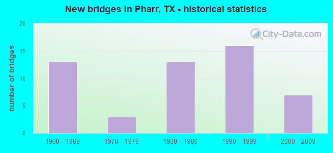
- New bridges - historical statistics
- 131960-1969
- 31970-1979
- 131980-1989
- 161990-1999
- 72000-2009

- Reconstructed bridges - Historical Statistics
- 41980-1989
- 41990-1999
- 82000-2009


- Bridge Condition - Deck
- 3.4%Very good
- 69.0%Good
- 27.6%Satisfactory

- Bridge Condition - Superstructure
- 10.3%Very good
- 75.9%Good
- 6.9%Satisfactory
- 6.9%Fair

- Bridge Condition - Substructure
- 65.5%Good
- 31.0%Satisfactory
- 3.4%Poor

- Bridge Condition - Channel
- 57.1%Good
- 21.4%Satisfactory
- 14.3%Fair
- 7.1%Poor

- Bridge Condition - Culverts
- 50.0%Good
- 25.0%Satisfactory
- 25.0%Poor
Find on map >> Show street view
Structure Number: 211090003917104, Location: 1.50 MI SW OF US 281 (Lat: 26.198142, Lng: -98.203442), Route carried "on" structure: US 83, Year Built: 1966, Year Reconstructed: 1998, Status: Open, Structure Length: 27.13m (89.01ft), Average Daily Traffic: 54,860 (year 2011), Truck Traffic: 6%, Average Future Daily Traffic: 76,810 (year 2031), Design Load: HS 20, Features Intersected: BU 83 FM 2061 & UP RR
Minimum Vertical Clearance: 30+ m (98+ ft), Kilometerpoint: 41.476, Lanes on structure: 4, Lanes under structure: 11, Owner: State Highway Agency, Approaching Roadway Width: 20.4m (66.9ft), Skew: 9 degrees, Material/Design: Prestressed concrete, Design/Construction: Stringer/Multi-beam, Number Of Spans In Main Unit: 12, Number Of Approach Spans: 5, Length of Maximum Span: 19.8m (65.0ft), Curb-To-Curb Width: 20.3m (66.6ft), Out-to-Out Width: 21.0m (68.9ft)
Condition: Deck: Good, Superstructure: Good, Substructure: Good, Operating Rating: 54.4 metric tons, Method Used To Determine Operating Rating: Assigned rating based on Load Factor Design (LFD) reported in metric tons, Inventory Rating: 32.7 metric tons, Method Used To Determine Inventory Rating: Assigned rating based on Load Factor Design (LFD) reported in metric tons, Structural Evaluation: Better than present minimum criteria, Deck Geometry: Equal to present minimum criteria, Underclear: High priority of corrective action, Approach Roadway Alignment: Equal to present desirable criteria, Designated Inspection Frequency: Every 24 months, Inspection Date: May 2021, Deck Structure Type: Concrete Cast-file-Place
Find on map >> Show street view
Structure Number: 211090003917105, Location: 1.50 MI SW OF US 281 (Lat: 26.198081, Lng: -98.203375), Route carried "on" structure: US 83, Year Built: 1960, Year Reconstructed: 1998, Status: Open, Structure Length: 29.69m (97.41ft), Average Daily Traffic: 54,860 (year 2011), Truck Traffic: 6%, Average Future Daily Traffic: 76,810 (year 2031), Design Load: HS 20, Features Intersected: BU 83 FM 2061 & UP RR
Minimum Vertical Clearance: 30+ m (98+ ft), Kilometerpoint: 41.449, Lanes on structure: 4, Lanes under structure: 11, Owner: State Highway Agency, Approaching Roadway Width: 20.4m (66.9ft), Skew: 9 degrees, Material/Design: Prestressed concrete, Design/Construction: Stringer/Multi-beam, Number Of Spans In Main Unit: 13, Number Of Approach Spans: 7, Length of Maximum Span: 19.8m (65.0ft), Curb-To-Curb Width: 20.3m (66.6ft), Out-to-Out Width: 21.0m (68.9ft)
Condition: Deck: Satisfactory, Superstructure: Satisfactory, Substructure: Good, Operating Rating: 54.4 metric tons, Method Used To Determine Operating Rating: Assigned rating based on Load Factor Design (LFD) reported in metric tons, Inventory Rating: 32.7 metric tons, Method Used To Determine Inventory Rating: Assigned rating based on Load Factor Design (LFD) reported in metric tons, Structural Evaluation: Equal to present minimum criteria, Deck Geometry: Equal to present minimum criteria, Underclear: High priority of corrective action, Approach Roadway Alignment: Equal to present desirable criteria, Designated Inspection Frequency: Every 24 months, Inspection Date: May 2021, Deck Structure Type: Concrete Cast-file-Place
Find on map >> Show street view
Structure Number: 211090003917106, Location: 0.75 MI W OF US 281 (Lat: 26.206167, Lng: -98.194322), Route carried "on" structure: US 83, Year Built: 1966, Year Reconstructed: 1993, Status: Open, Structure Length: 4.72m (15.49ft), Average Daily Traffic: 51,190 (year 2011), Truck Traffic: 7%, Average Future Daily Traffic: 71,670 (year 2031), Design Load: HS 20, Features Intersected: SUGAR RD
Minimum Vertical Clearance: 30+ m (98+ ft), Kilometerpoint: 42.895, Lanes on structure: 4, Lanes under structure: 4, Owner: State Highway Agency, Approaching Roadway Width: 20.4m (66.9ft), Material/Design: Prestressed concrete, Design/Construction: Stringer/Multi-beam, Number Of Spans In Main Unit: 1, Number Of Approach Spans: 2, Length of Maximum Span: 19.2m (63.0ft), Curb-To-Curb Width: 20.5m (67.3ft), Out-to-Out Width: 21.0m (68.9ft)
Condition: Deck: Good, Superstructure: Good, Substructure: Good, Operating Rating: 54.4 metric tons, Method Used To Determine Operating Rating: Assigned rating based on Load Factor Design (LFD) reported in metric tons, Inventory Rating: 32.7 metric tons, Method Used To Determine Inventory Rating: Assigned rating based on Load Factor Design (LFD) reported in metric tons, Structural Evaluation: Better than present minimum criteria, Deck Geometry: Equal to present minimum criteria, Underclear: Meets minimum limits, Approach Roadway Alignment: Equal to present desirable criteria, Length Of Structure Improvement: 4.72m (15.49ft), Designated Inspection Frequency: Every 24 months, Inspection Date: May 2021, Bridge Improvement Cost: $21,000, Roadway Improvement Cost: $5,000, Total Project Cost: $26,000, Deck Structure Type: Concrete Cast-file-Place
Find on map >> Show street view
Structure Number: 211090003917107, Location: 0.75 MI W OF US 281 (Lat: 26.206083, Lng: -98.194264), Route carried "on" structure: US 83, Year Built: 1966, Year Reconstructed: 1993, Status: Open, Structure Length: 4.72m (15.49ft), Average Daily Traffic: 51,190 (year 2011), Truck Traffic: 7%, Average Future Daily Traffic: 71,670 (year 2031), Design Load: HS 20, Features Intersected: SUGAR RD
Minimum Vertical Clearance: 30+ m (98+ ft), Kilometerpoint: 42.895, Lanes on structure: 4, Lanes under structure: 4, Owner: State Highway Agency, Approaching Roadway Width: 20.4m (66.9ft), Material/Design: Prestressed concrete, Design/Construction: Stringer/Multi-beam, Number Of Spans In Main Unit: 1, Number Of Approach Spans: 2, Length of Maximum Span: 19.2m (63.0ft), Curb-To-Curb Width: 20.4m (66.9ft), Out-to-Out Width: 21.0m (68.9ft)
Condition: Deck: Good, Superstructure: Good, Substructure: Good, Operating Rating: 54.4 metric tons, Method Used To Determine Operating Rating: Assigned rating based on Load Factor Design (LFD) reported in metric tons, Inventory Rating: 32.7 metric tons, Method Used To Determine Inventory Rating: Assigned rating based on Load Factor Design (LFD) reported in metric tons, Structural Evaluation: Better than present minimum criteria, Deck Geometry: Equal to present minimum criteria, Underclear: Meets minimum limits, Approach Roadway Alignment: Equal to present desirable criteria, Designated Inspection Frequency: Every 24 months, Inspection Date: May 2021, Deck Structure Type: Concrete Cast-file-Place
Find on map >> Show street view
Structure Number: 211090003917108, Location: US 83 @ US 281 (Lat: 26.206811, Lng: -98.181933), Route carried "on" structure: US 83, Year Built: 1966, Year Reconstructed: 1993, Status: Open, Structure Length: 5.67m (18.60ft), Average Daily Traffic: 51,190 (year 2011), Truck Traffic: 7%, Average Future Daily Traffic: 71,670 (year 2031), Design Load: HS 20, Features Intersected: US 281 (N CAGE BLVD)
Minimum Vertical Clearance: 30+ m (98+ ft), Kilometerpoint: 44.157, Lanes on structure: 3, Lanes under structure: 8, Owner: State Highway Agency, Approaching Roadway Width: 16.8m (55.1ft), Material/Design: Prestressed concrete, Design/Construction: Stringer/Multi-beam, Number Of Spans In Main Unit: 4, Length of Maximum Span: 15.9m (52.2ft), Curb-To-Curb Width: 16.9m (55.4ft), Out-to-Out Width: 17.4m (57.1ft)
Condition: Deck: Good, Superstructure: Fair, Substructure: Good, Operating Rating: 54.4 metric tons, Method Used To Determine Operating Rating: Assigned rating based on Load Factor Design (LFD) reported in metric tons, Inventory Rating: 18.1 metric tons, Method Used To Determine Inventory Rating: Assigned rating based on Load Factor Design (LFD) reported in metric tons, Structural Evaluation: Meets minimum limits, Deck Geometry: Equal to present minimum criteria, Underclear: High priority of corrective action, Approach Roadway Alignment: Equal to present desirable criteria, Designated Inspection Frequency: Every 24 months, Inspection Date: May 2021, Deck Structure Type: Concrete Cast-file-Place
Find on map >> Show street view
Structure Number: 211090003917109, Location: US 83 @ US 281 (Lat: 26.206711, Lng: -98.181953), Route carried "on" structure: US 83, Year Built: 1966, Year Reconstructed: 1993, Status: Open, Structure Length: 5.67m (18.60ft), Average Daily Traffic: 51,190 (year 2011), Truck Traffic: 7%, Average Future Daily Traffic: 71,670 (year 2031), Design Load: HS 20, Features Intersected: US 281 (N CAGE BLVD)
Minimum Vertical Clearance: 30+ m (98+ ft), Kilometerpoint: 44.157, Lanes on structure: 3, Lanes under structure: 8, Owner: State Highway Agency, Approaching Roadway Width: 16.8m (55.1ft), Material/Design: Prestressed concrete, Design/Construction: Stringer/Multi-beam, Number Of Spans In Main Unit: 4, Length of Maximum Span: 15.9m (52.2ft), Curb-To-Curb Width: 16.9m (55.4ft), Out-to-Out Width: 17.4m (57.1ft)
Condition: Deck: Good, Superstructure: Fair, Substructure: Good, Operating Rating: 54.4 metric tons, Method Used To Determine Operating Rating: Assigned rating based on Load Factor Design (LFD) reported in metric tons, Inventory Rating: 18.1 metric tons, Method Used To Determine Inventory Rating: Assigned rating based on Load Factor Design (LFD) reported in metric tons, Structural Evaluation: Meets minimum limits, Deck Geometry: Equal to present minimum criteria, Underclear: High priority of corrective action, Approach Roadway Alignment: Equal to present desirable criteria, Designated Inspection Frequency: Every 24 months, Inspection Date: May 2021, Deck Structure Type: Concrete Cast-file-Place
Find on map >> Show street view
Structure Number: 211090003917247, Location: 0.1 MI E OF US 281 (Lat: 26.207428, Lng: -98.181056), Route carried "on" structure: Ramp US 281, Year Built: 1993, Status: Open, Structure Length: 69.19m (227.00ft), Average Daily Traffic: 7,800 (year 2009), Truck Traffic: 19%, Average Future Daily Traffic: 10,600 (year 2029), Design Load: HS 20, Features Intersected: US 83 WB ON RAMP/FTG RD
Minimum Vertical Clearance: 30+ m (98+ ft), Kilometerpoint: 75.319, Lanes on structure: 1, Lanes under structure: 8, Owner: State Highway Agency, Approaching Roadway Width: 9.1m (29.9ft), Material/Design: Steel continuous, Design/Construction: Stringer/Multi-beam, Number Of Spans In Main Unit: 7, Number Of Approach Spans: 8, Length of Maximum Span: 67.1m (220.1ft), Curb-To-Curb Width: 8.8m (28.9ft), Out-to-Out Width: 9.8m (32.2ft)
Condition: Deck: Good, Superstructure: Good, Substructure: Good, Operating Rating: 44.4 metric tons, Method Used To Determine Operating Rating: Assigned ratings based on Allowable Stress Design (ASD) reported in metric tons, Inventory Rating: 32.7 metric tons, Method Used To Determine Inventory Rating: Assigned ratings based on Allowable Stress Design (ASD) reported in metric tons, Structural Evaluation: Better than present minimum criteria, Deck Geometry: Superior to present desirable criteria, Underclear: High priority of corrective action, Approach Roadway Alignment: Equal to present desirable criteria, Designated Inspection Frequency: Every 24 months, Critical Feature Inspection Frequency: Every 24 months, Inspection Date: May 2021, Critical Feature Inspection Date: June 2020, Deck Structure Type: Concrete Cast-file-Place
Find on map >> Show street view
Structure Number: 211090003917248, Location: US 83 / 281 INTERCHANGE (Lat: 26.206756, Lng: -98.183611), Route carried "on" structure: Ramp US 281, Year Built: 1993, Status: Open, Structure Length: 72.36m (237.40ft), Average Daily Traffic: 7,800 (year 2011), Truck Traffic: 19%, Average Future Daily Traffic: 10,600 (year 2031), Design Load: HS 20, Features Intersected: US 83
Minimum Vertical Clearance: 6.55m (21.49ft), Kilometerpoint: 75.256, Lanes on structure: 1, Lanes under structure: 13, Owner: State Highway Agency, Approaching Roadway Width: 8.8m (28.9ft), Material/Design: Steel continuous, Design/Construction: Stringer/Multi-beam, Number Of Spans In Main Unit: 4, Number Of Approach Spans: 14, Length of Maximum Span: 61.0m (200.1ft), Curb-To-Curb Width: 8.8m (28.9ft), Out-to-Out Width: 9.8m (32.2ft)
Condition: Deck: Satisfactory, Superstructure: Good, Substructure: Good, Operating Rating: 44.4 metric tons, Method Used To Determine Operating Rating: Assigned ratings based on Allowable Stress Design (ASD) reported in metric tons, Inventory Rating: 32.7 metric tons, Method Used To Determine Inventory Rating: Assigned ratings based on Allowable Stress Design (ASD) reported in metric tons, Structural Evaluation: Better than present minimum criteria, Deck Geometry: Superior to present desirable criteria, Underclear: High priority of corrective action, Approach Roadway Alignment: Equal to present desirable criteria, Designated Inspection Frequency: Every 24 months, Critical Feature Inspection Frequency: Every 24 months, Inspection Date: May 2021, Critical Feature Inspection Date: June 2020, Deck Structure Type: Concrete Cast-file-Place
Find on map >> Show street view
Structure Number: 21109000391725, Location: US 83 / 281 INTERCHANGE (Lat: 26.206453, Lng: -98.180239), Route carried "on" structure: Ramp US 281, Year Built: 1993, Status: Open, Structure Length: 50.99m (167.29ft), Average Daily Traffic: 7,800 (year 2011), Truck Traffic: 19%, Average Future Daily Traffic: 10,600 (year 2031), Design Load: HS 20, Features Intersected: US 83
Minimum Vertical Clearance: 30+ m (98+ ft), Kilometerpoint: 75.040, Lanes on structure: 1, Lanes under structure: 15, Owner: State Highway Agency, Approaching Roadway Width: 9.1m (29.9ft), Skew: 9 degrees, Material/Design: Steel continuous, Design/Construction: Stringer/Multi-beam, Number Of Spans In Main Unit: 3, Number Of Approach Spans: 7, Length of Maximum Span: 68.6m (225.1ft), Curb-To-Curb Width: 9.1m (29.9ft), Out-to-Out Width: 9.8m (32.2ft)
Condition: Deck: Good, Superstructure: Good, Substructure: Satisfactory, Operating Rating: 44.4 metric tons, Method Used To Determine Operating Rating: Assigned ratings based on Allowable Stress Design (ASD) reported in metric tons, Inventory Rating: 32.7 metric tons, Method Used To Determine Inventory Rating: Assigned ratings based on Allowable Stress Design (ASD) reported in metric tons, Structural Evaluation: Equal to present minimum criteria, Deck Geometry: Superior to present desirable criteria, Underclear: High priority of corrective action, Approach Roadway Alignment: Equal to present desirable criteria, Designated Inspection Frequency: Every 24 months, Critical Feature Inspection Frequency: Every 24 months, Inspection Date: May 2021, Critical Feature Inspection Date: April 2020, Deck Structure Type: Concrete Cast-file-Place
Find on map >> Show street view
Structure Number: 211090003917251, Location: US 83 / 281 INTERCHANGE (Lat: 26.207550, Lng: -98.182669), Route carried "on" structure: Ramp US 281, Year Built: 1993, Status: Open, Structure Length: 52.94m (173.69ft), Average Daily Traffic: 7,800 (year 2011), Truck Traffic: 19%, Average Future Daily Traffic: 10,600 (year 2031), Design Load: HS 20, Features Intersected: US 83 OFF RP & US 281
Minimum Vertical Clearance: 30+ m (98+ ft), Kilometerpoint: 75.036, Lanes on structure: 1, Lanes under structure: 6, Owner: State Highway Agency, Approaching Roadway Width: 9.1m (29.9ft), Skew: 9 degrees, Material/Design: Steel continuous, Design/Construction: Stringer/Multi-beam, Number Of Spans In Main Unit: 6, Number Of Approach Spans: 7, Length of Maximum Span: 74.7m (245.1ft), Curb-To-Curb Width: 8.8m (28.9ft), Out-to-Out Width: 9.8m (32.2ft)
Condition: Deck: Satisfactory, Superstructure: Good, Substructure: Satisfactory, Operating Rating: 44.4 metric tons, Method Used To Determine Operating Rating: Assigned ratings based on Allowable Stress Design (ASD) reported in metric tons, Inventory Rating: 32.7 metric tons, Method Used To Determine Inventory Rating: Assigned ratings based on Allowable Stress Design (ASD) reported in metric tons, Structural Evaluation: Equal to present minimum criteria, Deck Geometry: Superior to present desirable criteria, Underclear: High priority of corrective action, Approach Roadway Alignment: Equal to present desirable criteria, Designated Inspection Frequency: Every 24 months, Critical Feature Inspection Frequency: Every 24 months, Inspection Date: May 2021, Critical Feature Inspection Date: April 2020, Deck Structure Type: Concrete Cast-file-Place
Find on map >> Show street view
Structure Number: 211090003917263, Location: 1.0 MI E OF US 281 (Lat: 26.204367, Lng: -98.165858), Route carried "on" structure: US 83, Year Built: 1997, Status: Open, Structure Length: 6.95m (22.80ft), Average Daily Traffic: 58,180 (year 2011), Truck Traffic: 6%, Average Future Daily Traffic: 81,460 (year 2031), Design Load: HS 20, Features Intersected: NORTH I ROAD
Minimum Vertical Clearance: 30+ m (98+ ft), Kilometerpoint: 45.847, Lanes on structure: 4, Lanes under structure: 8, Owner: State Highway Agency, Approaching Roadway Width: 20.4m (66.9ft), Material/Design: Prestressed concrete, Design/Construction: Box Beam or Girders - Multiple, Number Of Spans In Main Unit: 1, Number Of Approach Spans: 2, Length of Maximum Span: 33.5m (109.9ft), Curb-To-Curb Width: 20.3m (66.6ft), Out-to-Out Width: 21.0m (68.9ft)
Condition: Deck: Good, Superstructure: Good, Substructure: Good, Operating Rating: 54.4 metric tons, Method Used To Determine Operating Rating: Assigned rating based on Load Factor Design (LFD) reported in metric tons, Inventory Rating: 32.7 metric tons, Method Used To Determine Inventory Rating: Assigned rating based on Load Factor Design (LFD) reported in metric tons, Structural Evaluation: Better than present minimum criteria, Deck Geometry: Equal to present minimum criteria, Underclear: Better than present minimum criteria, Approach Roadway Alignment: Equal to present desirable criteria, Designated Inspection Frequency: Every 24 months, Inspection Date: May 2021, Deck Structure Type: Concrete Cast-file-Place
Find on map >> Show street view
Structure Number: 211090025508071, Location: 1.85 MI N OF US 83 (Lat: 26.233297, Lng: -98.177747), Route carried "on" structure: US 281, Year Built: 1985, Year Reconstructed: 2005, Status: Open, Structure Length: 8.69m (28.51ft), Average Daily Traffic: 42,990 (year 2011), Truck Traffic: 20%, Average Future Daily Traffic: 65,860 (year 2031), Design Load: HS 20, Features Intersected: FM 3461 (NOLANA LP)
Minimum Vertical Clearance: 30+ m (98+ ft), Kilometerpoint: 9.794, Lanes on structure: 4, Lanes under structure: 8, Owner: State Highway Agency, Approaching Roadway Width: 21.0m (68.9ft), Material/Design: Prestressed concrete, Design/Construction: Stringer/Multi-beam, Number Of Spans In Main Unit: 3, Length of Maximum Span: 29.0m (95.1ft), Curb-To-Curb Width: 21.0m (68.9ft), Out-to-Out Width: 21.6m (70.9ft)
Condition: Deck: Good, Superstructure: Good, Substructure: Satisfactory, Operating Rating: 54.4 metric tons, Method Used To Determine Operating Rating: Assigned rating based on Load Factor Design (LFD) reported in metric tons, Inventory Rating: 32.7 metric tons, Method Used To Determine Inventory Rating: Assigned rating based on Load Factor Design (LFD) reported in metric tons, Structural Evaluation: Equal to present minimum criteria, Deck Geometry: Better than present minimum criteria, Underclear: Meets minimum limits, Approach Roadway Alignment: Equal to present desirable criteria, Designated Inspection Frequency: Every 24 months, Inspection Date: May 2021, Deck Structure Type: Concrete Precast Panels
Find on map >> Show street view
Structure Number: 211090025508072, Location: 1.85 MI N OF US 83 (Lat: 26.233661, Lng: -98.178006), Route carried "on" structure: US 281, Year Built: 1985, Year Reconstructed: 2005, Status: Open, Structure Length: 8.69m (28.51ft), Average Daily Traffic: 42,990 (year 2011), Truck Traffic: 20%, Average Future Daily Traffic: 65,860 (year 2031), Design Load: HS 20, Features Intersected: FM 3461 (NOLANA LP)
Minimum Vertical Clearance: 30+ m (98+ ft), Kilometerpoint: 9.794, Lanes on structure: 4, Lanes under structure: 8, Owner: State Highway Agency, Approaching Roadway Width: 21.0m (68.9ft), Material/Design: Prestressed concrete, Design/Construction: Stringer/Multi-beam, Number Of Spans In Main Unit: 3, Length of Maximum Span: 29.0m (95.1ft), Curb-To-Curb Width: 21.0m (68.9ft), Out-to-Out Width: 21.6m (70.9ft)
Condition: Deck: Good, Superstructure: Good, Substructure: Satisfactory, Operating Rating: 54.4 metric tons, Method Used To Determine Operating Rating: Assigned rating based on Load Factor Design (LFD) reported in metric tons, Inventory Rating: 32.7 metric tons, Method Used To Determine Inventory Rating: Assigned rating based on Load Factor Design (LFD) reported in metric tons, Structural Evaluation: Equal to present minimum criteria, Deck Geometry: Better than present minimum criteria, Underclear: Meets minimum limits, Approach Roadway Alignment: Equal to present desirable criteria, Designated Inspection Frequency: Every 24 months, Inspection Date: May 2021, Deck Structure Type: Concrete Precast Panels
Find on map >> Show street view
Structure Number: 211090025508073, Location: 1.05 MI N OF US 83 (Lat: 26.222217, Lng: -98.179203), Route carried "on" structure: ServiceUS 281, Year Built: 1985, Year Reconstructed: 2005, Status: Open, Structure Length: 1.83m (6.00ft), Average Daily Traffic: 21,130 (year 2019), Truck Traffic: 3%, Average Future Daily Traffic: 23,090 (year 2031), Design Load: HS 20, Features Intersected: PHARR-MCALLEN LATERAL
Minimum Vertical Clearance: 30+ m (98+ ft), Kilometerpoint: 11.053, Lanes on structure: 3, Owner: State Highway Agency, Approaching Roadway Width: 11.6m (38.1ft), Material/Design: Concrete continuous, Design/Construction: Slab, Number Of Spans In Main Unit: 3, Length of Maximum Span: 7.3m (24.0ft), Curb-To-Curb Width: 11.6m (38.1ft), Out-to-Out Width: 12.4m (40.7ft)
Condition: Deck: Good, Superstructure: Good, Substructure: Good, Channel: Satisfactory, Operating Rating: 68.0 metric tons, Method Used To Determine Operating Rating: Load Factor (LF), Inventory Rating: 40.8 metric tons, Method Used To Determine Inventory Rating: Load Factor (LF), Structural Evaluation: Better than present minimum criteria, Deck Geometry: High priority of replacement, Waterway Adequacy: Better than present minimum criteria, Approach Roadway Alignment: Equal to present desirable criteria, Length Of Structure Improvement: 1.83m (6.00ft), Designated Inspection Frequency: Every 24 months, Inspection Date: May 2021, Bridge Improvement Cost: $5,000, Roadway Improvement Cost: $1,000, Total Project Cost: $6,000, Deck Structure Type: Concrete Cast-file-Place
Find on map >> Show street view
Structure Number: 211090025508074, Location: 1.05 MI N OF US 83 (Lat: 26.222383, Lng: -98.179611), Route carried "on" structure: US 281, Year Built: 1985, Year Reconstructed: 2005, Status: Open, Structure Length: 1.83m (6.00ft), Average Daily Traffic: 40,990 (year 2011), Truck Traffic: 21%, Average Future Daily Traffic: 61,400 (year 2031), Design Load: HS 20, Features Intersected: PHARR-MCALLEN LATERAL
Minimum Vertical Clearance: 30+ m (98+ ft), Kilometerpoint: 11.053, Lanes on structure: 5, Owner: State Highway Agency, Approaching Roadway Width: 21.3m (69.9ft), Material/Design: Concrete continuous, Design/Construction: Slab, Number Of Spans In Main Unit: 3, Length of Maximum Span: 7.3m (24.0ft), Curb-To-Curb Width: 29.5m (96.8ft), Out-to-Out Width: 34.3m (112.5ft)
Condition: Deck: Good, Superstructure: Good, Substructure: Good, Channel: Good, Operating Rating: 68.0 metric tons, Method Used To Determine Operating Rating: Load Factor (LF), Inventory Rating: 40.8 metric tons, Method Used To Determine Inventory Rating: Load Factor (LF), Structural Evaluation: Better than present minimum criteria, Deck Geometry: Superior to present desirable criteria, Waterway Adequacy: Equal to present minimum criteria, Approach Roadway Alignment: Equal to present desirable criteria, Designated Inspection Frequency: Every 24 months, Inspection Date: May 2021, Deck Structure Type: Concrete Cast-file-Place
Find on map >> Show street view
Structure Number: 211090025508075, Location: 1.05 MI N OF US 83 (Lat: 26.222444, Lng: -98.179903), Route carried "on" structure: US 281, Year Built: 1985, Year Reconstructed: 2005, Status: Open, Structure Length: 1.83m (6.00ft), Average Daily Traffic: 40,990 (year 2011), Truck Traffic: 21%, Average Future Daily Traffic: 61,400 (year 2031), Design Load: HS 20, Features Intersected: PHARR-MCALLEN LATERAL
Minimum Vertical Clearance: 30+ m (98+ ft), Kilometerpoint: 11.053, Lanes on structure: 7, Owner: State Highway Agency, Approaching Roadway Width: 33.5m (109.9ft), Material/Design: Concrete continuous, Design/Construction: Slab, Number Of Spans In Main Unit: 3, Length of Maximum Span: 7.3m (24.0ft), Curb-To-Curb Width: 41.1m (134.8ft), Out-to-Out Width: 53.6m (175.9ft)
Condition: Deck: Good, Superstructure: Good, Substructure: Satisfactory, Channel: Good, Operating Rating: 68.0 metric tons, Method Used To Determine Operating Rating: Load Factor (LF), Inventory Rating: 40.8 metric tons, Method Used To Determine Inventory Rating: Load Factor (LF), Structural Evaluation: Equal to present minimum criteria, Deck Geometry: Superior to present desirable criteria, Waterway Adequacy: Equal to present minimum criteria, Approach Roadway Alignment: Equal to present desirable criteria, Designated Inspection Frequency: Every 24 months, Inspection Date: May 2021, Deck Structure Type: Concrete Cast-file-Place
Find on map >> Show street view
Structure Number: 211090025508076, Location: 0.85 MI N OF US 83 (Lat: 26.218939, Lng: -98.180181), Route carried "on" structure: US 281, Year Built: 1985, Year Reconstructed: 2005, Status: Open, Structure Length: 8.69m (28.51ft), Average Daily Traffic: 40,990 (year 2011), Truck Traffic: 21%, Average Future Daily Traffic: 61,400 (year 2031), Design Load: HS 20, Features Intersected: SIOUX RD
Minimum Vertical Clearance: 30+ m (98+ ft), Kilometerpoint: 11.404, Lanes on structure: 4, Lanes under structure: 8, Owner: State Highway Agency, Approaching Roadway Width: 21.0m (68.9ft), Material/Design: Prestressed concrete, Design/Construction: Stringer/Multi-beam, Number Of Spans In Main Unit: 3, Length of Maximum Span: 29.0m (95.1ft), Curb-To-Curb Width: 21.0m (68.9ft), Out-to-Out Width: 21.6m (70.9ft)
Condition: Deck: Good, Superstructure: Good, Substructure: Satisfactory, Operating Rating: 54.4 metric tons, Method Used To Determine Operating Rating: Assigned rating based on Load Factor Design (LFD) reported in metric tons, Inventory Rating: 32.7 metric tons, Method Used To Determine Inventory Rating: Assigned rating based on Load Factor Design (LFD) reported in metric tons, Structural Evaluation: Equal to present minimum criteria, Deck Geometry: Better than present minimum criteria, Underclear: Meets minimum limits, Approach Roadway Alignment: Equal to present desirable criteria, Designated Inspection Frequency: Every 24 months, Inspection Date: May 2021, Deck Structure Type: Concrete Precast Panels
Find on map >> Show street view
Structure Number: 211090025508077, Location: 0.85 MI N OF US 83 (Lat: 26.219303, Lng: -98.180431), Route carried "on" structure: US 281, Year Built: 1985, Year Reconstructed: 2005, Status: Open, Structure Length: 8.69m (28.51ft), Average Daily Traffic: 40,990 (year 2011), Truck Traffic: 21%, Average Future Daily Traffic: 61,400 (year 2031), Design Load: HS 20, Features Intersected: SIOUX RD
Minimum Vertical Clearance: 30+ m (98+ ft), Kilometerpoint: 11.404, Lanes on structure: 4, Lanes under structure: 8, Owner: State Highway Agency, Approaching Roadway Width: 21.0m (68.9ft), Material/Design: Prestressed concrete, Design/Construction: Stringer/Multi-beam, Number Of Spans In Main Unit: 3, Length of Maximum Span: 29.0m (95.1ft), Curb-To-Curb Width: 21.0m (68.9ft), Out-to-Out Width: 21.6m (70.9ft)
Condition: Deck: Good, Superstructure: Good, Substructure: Satisfactory, Operating Rating: 54.4 metric tons, Method Used To Determine Operating Rating: Assigned rating based on Load Factor Design (LFD) reported in metric tons, Inventory Rating: 32.7 metric tons, Method Used To Determine Inventory Rating: Assigned rating based on Load Factor Design (LFD) reported in metric tons, Structural Evaluation: Equal to present minimum criteria, Deck Geometry: Better than present minimum criteria, Underclear: Meets minimum limits, Approach Roadway Alignment: Equal to present desirable criteria, Designated Inspection Frequency: Every 24 months, Inspection Date: May 2021, Deck Structure Type: Concrete Precast Panels
Find on map >> Show street view
Structure Number: 211090025508246, Location: 0.10 MI N OF US 83 (Lat: 26.210442, Lng: -98.181314), Route carried "on" structure: Ramp US 281, Year Built: 1993, Status: Open, Structure Length: 36.73m (120.51ft), Average Daily Traffic: 8,190 (year 2011), Truck Traffic: 21%, Average Future Daily Traffic: 12,280 (year 2031), Design Load: HS 20, Features Intersected: FM 495
Minimum Vertical Clearance: 30+ m (98+ ft), Kilometerpoint: 12.239, Lanes on structure: 2, Lanes under structure: 8, Owner: State Highway Agency, Approaching Roadway Width: 11.6m (38.1ft), Material/Design: Prestressed concrete, Design/Construction: Stringer/Multi-beam, Number Of Spans In Main Unit: 11, Length of Maximum Span: 36.6m (120.1ft), Curb-To-Curb Width: 11.3m (37.1ft), Out-to-Out Width: 12.2m (40.0ft)
Condition: Deck: Satisfactory, Superstructure: Good, Substructure: Good, Operating Rating: 54.4 metric tons, Method Used To Determine Operating Rating: Assigned rating based on Load Factor Design (LFD) reported in metric tons, Inventory Rating: 32.7 metric tons, Method Used To Determine Inventory Rating: Assigned rating based on Load Factor Design (LFD) reported in metric tons, Structural Evaluation: Better than present minimum criteria, Deck Geometry: Superior to present desirable criteria, Underclear: Equal to present minimum criteria, Approach Roadway Alignment: Equal to present desirable criteria, Designated Inspection Frequency: Every 24 months, Inspection Date: May 2021, Deck Structure Type: Concrete Precast Panels
Find on map >> Show street view
Structure Number: 211090025508249, Location: 0.10 MI N OF US 83 (Lat: 26.210461, Lng: -98.181514), Route carried "on" structure: Ramp US 281, Year Built: 1993, Status: Open, Structure Length: 34.56m (113.39ft), Average Daily Traffic: 8,190 (year 2011), Truck Traffic: 21%, Average Future Daily Traffic: 12,280 (year 2031), Design Load: HS 20, Features Intersected: FM 495
Minimum Vertical Clearance: 30+ m (98+ ft), Kilometerpoint: 12.239, Lanes on structure: 2, Lanes under structure: 8, Owner: State Highway Agency, Approaching Roadway Width: 11.6m (38.1ft), Material/Design: Prestressed concrete, Design/Construction: Stringer/Multi-beam, Number Of Spans In Main Unit: 11, Length of Maximum Span: 33.5m (109.9ft), Curb-To-Curb Width: 11.3m (37.1ft), Out-to-Out Width: 12.2m (40.0ft)
Condition: Deck: Satisfactory, Superstructure: Good, Substructure: Good, Operating Rating: 54.4 metric tons, Method Used To Determine Operating Rating: Assigned rating based on Load Factor Design (LFD) reported in metric tons, Inventory Rating: 32.7 metric tons, Method Used To Determine Inventory Rating: Assigned rating based on Load Factor Design (LFD) reported in metric tons, Structural Evaluation: Better than present minimum criteria, Deck Geometry: Superior to present desirable criteria, Underclear: Equal to present minimum criteria, Approach Roadway Alignment: Equal to present desirable criteria, Designated Inspection Frequency: Every 24 months, Inspection Date: May 2021, Deck Structure Type: Concrete Precast Panels
Find on map >> Show street view
Structure Number: 211090025508271, Location: 1.0 MI N OF FM 3461 (Lat: 26.247306, Lng: -98.175186), Route carried "on" structure: US 281, Year Built: 2006, Status: Open, Structure Length: 7.16m (23.49ft), Average Daily Traffic: 42,990 (year 2011), Truck Traffic: 20%, Average Future Daily Traffic: 65,860 (year 2031), Design Load: HS 25 or greater, Features Intersected: OWASSA ROAD
Minimum Vertical Clearance: 30+ m (98+ ft), Kilometerpoint: 8.193, Lanes on structure: 4, Lanes under structure: 8, Owner: State Highway Agency, Approaching Roadway Width: 21.0m (68.9ft), Skew: 9 degrees, Material/Design: Prestressed concrete, Design/Construction: Stringer/Multi-beam, Number Of Spans In Main Unit: 1, Number Of Approach Spans: 2, Length of Maximum Span: 35.1m (115.2ft), Curb-To-Curb Width: 21.0m (68.9ft), Out-to-Out Width: 21.6m (70.9ft)
Condition: Deck: Good, Superstructure: Good, Substructure: Good, Operating Rating: 68.0 metric tons, Method Used To Determine Operating Rating: Assigned rating based on Load Factor Design (LFD) reported in metric tons, Inventory Rating: 40.8 metric tons, Method Used To Determine Inventory Rating: Assigned rating based on Load Factor Design (LFD) reported in metric tons, Structural Evaluation: Better than present minimum criteria, Deck Geometry: Better than present minimum criteria, Underclear: Superior to present desirable criteria, Approach Roadway Alignment: Equal to present desirable criteria, Designated Inspection Frequency: Every 24 months, Inspection Date: May 2021, Deck Structure Type: Concrete Precast Panels
Find on map >> Show street view
Structure Number: 211090025509031, Location: 1.7 MI S OF BUS 83 (Lat: 26.170142, Lng: -98.188144), Route carried "on" structure: US 281, Year Built: 1964, Year Reconstructed: 1996, Status: Open, Structure Length: 0.94m (3.08ft), Average Daily Traffic: 18,300 (year 2020), Truck Traffic: 19%, Average Future Daily Traffic: 36,670 (year 2033), Features Intersected: DRAINAGE D
Minimum Vertical Clearance: 30+ m (98+ ft), Kilometerpoint: 69.345, Lanes on structure: 5, Owner: State Highway Agency, Approaching Roadway Width: 25.6m (84.0ft), Skew: 1 degrees, Material/Design: Concrete, Design/Construction: Culvert, Number Of Spans In Main Unit: 3, Length of Maximum Span: 2.7m (8.9ft), Curb-To-Curb Width: 25.6m (84.0ft), Out-to-Out Width: 29.3m (96.1ft)
Condition: Channel: Satisfactory, Culverts: Good, Operating Rating: 32.7 metric tons, Method Used To Determine Operating Rating: Field evaluation and documented engineering judgment, Inventory Rating: 24.5 metric tons, Method Used To Determine Inventory Rating: Field evaluation and documented engineering judgment, Structural Evaluation: Equal to present minimum criteria, Deck Geometry: Superior to present desirable criteria, Waterway Adequacy: Equal to present minimum criteria, Approach Roadway Alignment: Equal to present desirable criteria, Designated Inspection Frequency: Every 24 months, Inspection Date: May 2021, Deck Structure Type: Concrete Cast-file-Place, Wearing Surface/Protective System: Wearing Surface: Bituminous
Find on map >> Show street view
Structure Number: 21109002550908, Location: 0.30 MI S OF FM 3072 (Lat: 26.118647, Lng: -98.196825), Route carried "on" structure: US 281, Year Built: 1993, Status: Open, Structure Length: 1.10m (3.61ft), Average Daily Traffic: 6,888 (year 2020), Truck Traffic: 19%, Average Future Daily Traffic: 14,500 (year 2033), Design Load: HS 20, Features Intersected: DRAIN
Minimum Vertical Clearance: 30+ m (98+ ft), Kilometerpoint: 74.873, Lanes on structure: 5, Owner: State Highway Agency, Approaching Roadway Width: 25.6m (84.0ft), Material/Design: Concrete, Design/Construction: Culvert, Number Of Spans In Main Unit: 3, Length of Maximum Span: 3.0m (9.8ft), Curb or Sidewalk Widths: Left: 1.8m (5.9ft), Right: 2.1m (6.9ft)
Condition: Channel: Good, Culverts: Good, Operating Rating: 39.9 metric tons, Method Used To Determine Operating Rating: Load Factor (LF), Inventory Rating: 23.6 metric tons, Method Used To Determine Inventory Rating: Load Factor (LF), Structural Evaluation: Somewhat better than minimum adequacy, Waterway Adequacy: Equal to present minimum criteria, Approach Roadway Alignment: Equal to present desirable criteria, Designated Inspection Frequency: Every 48 months, Inspection Date: April 2021
Find on map >> Show street view
Structure Number: 211090025509091, Location: 3.30 MI S OF BUS 83 (Lat: 26.147539, Lng: -98.192278), Route carried "on" structure: ServiceUS 281, Year Built: 2000, Status: Open, Structure Length: 4.21m (13.81ft), Average Daily Traffic: 500 (year 2011), Truck Traffic: 2%, Average Future Daily Traffic: 6,550 (year 2031), Design Load: HS 20, Features Intersected: MAIN FLDWY PILOT CHANNEL
Minimum Vertical Clearance: 30+ m (98+ ft), Kilometerpoint: 12.649, Lanes on structure: 2, Owner: State Highway Agency, Approaching Roadway Width: 7.3m (24.0ft), Material/Design: Prestressed concrete, Design/Construction: Slab, Number Of Spans In Main Unit: 3, Length of Maximum Span: 14.9m (48.9ft), Curb-To-Curb Width: 10.4m (34.1ft), Out-to-Out Width: 11.2m (36.7ft)
Condition: Deck: Good, Superstructure: Very good, Substructure: Good, Channel: Satisfactory, Operating Rating: 54.4 metric tons, Method Used To Determine Operating Rating: Assigned rating based on Load Factor Design (LFD) reported in metric tons, Inventory Rating: 32.7 metric tons, Method Used To Determine Inventory Rating: Assigned rating based on Load Factor Design (LFD) reported in metric tons, Structural Evaluation: Better than present minimum criteria, Deck Geometry: Equal to present minimum criteria, Waterway Adequacy: High priority of replacement, Approach Roadway Alignment: Equal to present desirable criteria, Designated Inspection Frequency: Every 24 months, Inspection Date: April 2021, Deck Structure Type: Concrete Cast-file-Place
Find on map >> Show street view
Structure Number: 211090025509092, Location: 3.30 MI S OF BUS 83 (Lat: 26.142339, Lng: -98.192711), Route carried "on" structure: US 281, Year Built: 2000, Status: Open, Structure Length: 89.79m (294.59ft), Average Daily Traffic: 14,253 (year 2020), Truck Traffic: 19%, Average Future Daily Traffic: 28,510 (year 2033), Design Load: HS 25 or greater, Features Intersected: MAIN FLOODWAY
Minimum Vertical Clearance: 30+ m (98+ ft), Kilometerpoint: 71.891, Lanes on structure: 4, Owner: State Highway Agency, Approaching Roadway Width: 24.4m (80.1ft), Skew: 30 degrees, Material/Design: Prestressed concrete, Design/Construction: Stringer/Multi-beam, Number Of Spans In Main Unit: 27, Number Of Approach Spans: 3, Length of Maximum Span: 36.0m (118.1ft), Curb-To-Curb Width: 22.6m (74.1ft), Out-to-Out Width: 24.0m (78.7ft)
Condition: Deck: Good, Superstructure: Good, Substructure: Good, Channel: Good, Operating Rating: 68.0 metric tons, Method Used To Determine Operating Rating: Assigned rating based on Load Factor Design (LFD) reported in metric tons, Inventory Rating: 40.8 metric tons, Method Used To Determine Inventory Rating: Assigned rating based on Load Factor Design (LFD) reported in metric tons, Structural Evaluation: Better than present minimum criteria, Deck Geometry: Superior to present desirable criteria, Waterway Adequacy: Superior to present desirable criteria, Approach Roadway Alignment: Equal to present desirable criteria, Designated Inspection Frequency: Every 24 months, Inspection Date: April 2021, Deck Structure Type: Concrete Precast Panels
Find on map >> Show street view
Structure Number: 211090025509252, Location: SP 241 JCT US 281 (Lat: 26.094572, Lng: -98.200353), Route carried "on" structure: Spur State highway 241, Year Built: 2003, Status: Open, Structure Length: 8.05m (26.41ft), Average Daily Traffic: 11,613 (year 2020), Truck Traffic: 19%, Average Future Daily Traffic: 21,800 (year 2031), Design Load: HS 20, Features Intersected: US 281
Minimum Vertical Clearance: 30+ m (98+ ft), Kilometerpoint: 0.002, Lanes on structure: 4, Lanes under structure: 8, Owner: State Highway Agency, Approaching Roadway Width: 23.2m (76.1ft), Skew: 30 degrees, Material/Design: Prestressed concrete, Design/Construction: Stringer/Multi-beam, Number Of Spans In Main Unit: 1, Number Of Approach Spans: 2, Length of Maximum Span: 35.1m (115.2ft), Curb-To-Curb Width: 23.0m (75.5ft), Out-to-Out Width: 24.4m (80.1ft)
Condition: Deck: Good, Superstructure: Good, Substructure: Good, Operating Rating: 54.4 metric tons, Method Used To Determine Operating Rating: Assigned rating based on Load Factor Design (LFD) reported in metric tons, Inventory Rating: 32.7 metric tons, Method Used To Determine Inventory Rating: Assigned rating based on Load Factor Design (LFD) reported in metric tons, Structural Evaluation: Better than present minimum criteria, Deck Geometry: Superior to present desirable criteria, Underclear: Equal to present minimum criteria, Approach Roadway Alignment: Equal to present desirable criteria, Designated Inspection Frequency: Every 24 months, Inspection Date: April 2021, Deck Structure Type: Concrete Precast Panels
Find on map >> Show street view
Structure Number: 211090193902006, Location: 3.70 MI S OF US 83 (Lat: 26.143922, Lng: -98.213314), Route carried "on" structure: State highway 2061, Year Built: 1978, Year Reconstructed: 2008, Status: Open, Structure Length: 6.10m (20.01ft), Average Daily Traffic: 19,337 (year 2020), Truck Traffic: 3%, Average Future Daily Traffic: 31,840 (year 2033), Design Load: HS 20, Features Intersected: HACKNEY LAKE FLOODWAY
Minimum Vertical Clearance: 30+ m (98+ ft), Kilometerpoint: 6.146, Lanes on structure: 5, Owner: State Highway Agency, Approaching Roadway Width: 25.6m (84.0ft), Material/Design: Concrete continuous, Design/Construction: Slab, Number Of Spans In Main Unit: 8, Length of Maximum Span: 7.6m (24.9ft), Curb-To-Curb Width: 25.5m (83.7ft), Out-to-Out Width: 26.2m (86.0ft)
Condition: Deck: Good, Superstructure: Good, Substructure: Good, Channel: Good, Operating Rating: 40.8 metric tons, Method Used To Determine Operating Rating: Load Factor (LF), Inventory Rating: 24.5 metric tons, Method Used To Determine Inventory Rating: Load Factor (LF), Structural Evaluation: Equal to present minimum criteria, Deck Geometry: Superior to present desirable criteria, Waterway Adequacy: Equal to present minimum criteria, Approach Roadway Alignment: Equal to present desirable criteria, Designated Inspection Frequency: Every 24 months, Inspection Date: May 2021, Deck Structure Type: Concrete Cast-file-Place, Wearing Surface/Protective System: Wearing Surface: Bituminous
Find on map >> Show street view
Structure Number: 211090193902007, Location: 0.25 MI S OF FM 3072 (Lat: 26.122025, Lng: -98.217019), Route carried "on" structure: State highway 2061, Year Built: 1988, Year Reconstructed: 2001, Status: Open, Structure Length: 2.29m (7.51ft), Average Daily Traffic: 9,491 (year 2020), Truck Traffic: 3%, Average Future Daily Traffic: 15,940 (year 2033), Design Load: HS 20, Features Intersected: HC MASTER DRAIN
Minimum Vertical Clearance: 30+ m (98+ ft), Kilometerpoint: 8.581, Lanes on structure: 5, Owner: State Highway Agency, Approaching Roadway Width: 25.0m (82.0ft), Material/Design: Prestressed concrete, Number Of Spans In Main Unit: 2, Length of Maximum Span: 12.2m (40.0ft), Curb or Sidewalk Widths: Left: 1.6m (5.2ft), Right: 1.6m (5.2ft), Curb-To-Curb Width: 25.1m (82.3ft), Out-to-Out Width: 29.6m (97.1ft)
Condition: Deck: Very good, Superstructure: Very good, Substructure: Good, Channel: Good, Operating Rating: 54.4 metric tons, Method Used To Determine Operating Rating: Assigned rating based on Load Factor Design (LFD) reported in metric tons, Inventory Rating: 32.7 metric tons, Method Used To Determine Inventory Rating: Assigned rating based on Load Factor Design (LFD) reported in metric tons, Structural Evaluation: Better than present minimum criteria, Deck Geometry: Superior to present desirable criteria, Waterway Adequacy: Superior to present desirable criteria, Approach Roadway Alignment: Equal to present desirable criteria, Designated Inspection Frequency: Every 24 months, Inspection Date: April 2021, Deck Structure Type: Other, Wearing Surface/Protective System: Wearing Surface: Bituminous
Find on map >> Show street view
Structure Number: 211090193902102, Location: 3.90 MI S OF US 83 (Lat: 26.140856, Lng: -98.213819), Route carried "on" structure: State highway 2061, Year Built: 2008, Status: Open, Structure Length: 0.64m (2.10ft), Average Daily Traffic: 19,337 (year 2020), Truck Traffic: 4%, Average Future Daily Traffic: 40,830 (year 2029), Design Load: HS 20, Features Intersected: IRRIGATION CANAL
Minimum Vertical Clearance: 30+ m (98+ ft), Kilometerpoint: 6.482, Lanes on structure: 5, Owner: State Highway Agency, Approaching Roadway Width: 25.6m (84.0ft), Material/Design: Concrete, Design/Construction: Culvert, Number Of Spans In Main Unit: 2, Length of Maximum Span: 2.7m (8.9ft)
Condition: Channel: Good, Culverts: Satisfactory, Operating Rating: 54.4 metric tons, Method Used To Determine Operating Rating: Assigned rating based on Load Factor Design (LFD) reported in metric tons, Inventory Rating: 32.7 metric tons, Method Used To Determine Inventory Rating: Assigned rating based on Load Factor Design (LFD) reported in metric tons, Structural Evaluation: Equal to present minimum criteria, Waterway Adequacy: Equal to present minimum criteria, Approach Roadway Alignment: Equal to present desirable criteria, Designated Inspection Frequency: Every 48 months, Inspection Date: May 2021
Find on map >> Show street view
Structure Number: 211090AA0653002, Location: 1.33 MI E OF US 281 (Lat: 26.113239, Lng: -98.176044), Route carried "on" structure: County highway , Year Built: 1975, Status: Posted for load, Structure Length: 1.92m (6.30ft), Average Daily Traffic: 225 (year 2014), Average Future Daily Traffic: 90 (year 2032), Features Intersected: S FLOODWATER CHANNEL, Facility Carried by Structure: LAS MILPAS ROAD
Minimum Vertical Clearance: 30+ m (98+ ft), Kilometerpoint: 6.759, Lanes on structure: 2, Owner: County Highway Agency, Approaching Roadway Width: 5.5m (18.0ft), Material/Design: Concrete, Design/Construction: Stringer/Multi-beam, Number Of Spans In Main Unit: 2, Length of Maximum Span: 9.1m (29.9ft), Curb-To-Curb Width: 6.8m (22.3ft), Out-to-Out Width: 7.6m (24.9ft)
Condition: Deck: Satisfactory, Superstructure: Good, Substructure: Satisfactory, Channel: Fair, Operating Rating: 32.7 metric tons, Method Used To Determine Operating Rating: Field evaluation and documented engineering judgment, Inventory Rating: 24.5 metric tons, Method Used To Determine Inventory Rating: Field evaluation and documented engineering judgment, Structural Evaluation: Equal to present minimum criteria, Deck Geometry: Meets minimum limits, Waterway Adequacy: Better than present minimum criteria, Approach Roadway Alignment: Equal to present desirable criteria, Bridge Posting: Required (Relationship of Operating Rating to Maximum Legal Load: 20.0 - 29.9% below), Designated Inspection Frequency: Every 24 months, Inspection Date: April 2020, Deck Structure Type: Concrete Cast-file-Place
Find on map >> Show street view
Structure Number: 211090AA0657001, Location: 0.22 MI S OF FM 3072 (Lat: 26.117611, Lng: -98.180333), Route carried "on" structure: County highway , Year Built: 1975, Status: Posted for load, Structure Length: 1.92m (6.30ft), Average Daily Traffic: 764 (year 2018), Truck Traffic: 2%, Average Future Daily Traffic: 500 (year 2032), Features Intersected: S FLOODWATER CHANNEL, Facility Carried by Structure: VETERANS BLVD I
Minimum Vertical Clearance: 30+ m (98+ ft), Kilometerpoint: 3.058, Lanes on structure: 2, Owner: County Highway Agency, Approaching Roadway Width: 5.5m (18.0ft), Material/Design: Concrete, Design/Construction: Stringer/Multi-beam, Number Of Spans In Main Unit: 2, Length of Maximum Span: 9.1m (29.9ft), Curb-To-Curb Width: 6.8m (22.3ft), Out-to-Out Width: 7.6m (24.9ft)
Condition: Deck: Satisfactory, Superstructure: Satisfactory, Substructure: Poor, Channel: Fair, Operating Rating: 32.7 metric tons, Method Used To Determine Operating Rating: Field evaluation and documented engineering judgment, Inventory Rating: 24.5 metric tons, Method Used To Determine Inventory Rating: Field evaluation and documented engineering judgment, Structural Evaluation: Meets minimum limits, Deck Geometry: Meets minimum limits, Waterway Adequacy: Better than present minimum criteria, Approach Roadway Alignment: Equal to present desirable criteria, Bridge Posting: Required (Relationship of Operating Rating to Maximum Legal Load: 20.0 - 29.9% below), Designated Inspection Frequency: Every 24 months, Inspection Date: April 2020, Deck Structure Type: Concrete Cast-file-Place
Find on map >> Show street view
Structure Number: 211090AA1406001, Location: 0.13 MI S OF N LEVEE ROAD (Lat: 26.147919, Lng: -98.203719), Route carried "on" structure: County highway , Year Built: 1988, Status: Posted for load, Structure Length: 1.24m (4.07ft), Average Daily Traffic: 80 (year 2010), Average Future Daily Traffic: 110 (year 2029), Features Intersected: HACKNEY LAKE INLET, Facility Carried by Structure: IB&WC ROAD
Minimum Vertical Clearance: 30+ m (98+ ft), Kilometerpoint: 0.209, Lanes on structure: 1, Owner: County Highway Agency, Approaching Roadway Width: 3.7m (12.1ft), Material/Design: Concrete, Design/Construction: Culvert, Number Of Spans In Main Unit: 4, Length of Maximum Span: 2.4m (7.9ft), Curb-To-Curb Width: 5.5m (18.0ft), Out-to-Out Width: 5.9m (19.4ft)
Condition: Channel: Poor, Culverts: Poor, Operating Rating: 32.7 metric tons, Method Used To Determine Operating Rating: Field evaluation and documented engineering judgment, Inventory Rating: 24.5 metric tons, Method Used To Determine Inventory Rating: Field evaluation and documented engineering judgment, Structural Evaluation: Meets minimum limits, Deck Geometry: Meets minimum limits, Waterway Adequacy: Meets minimum limits, Approach Roadway Alignment: Somewhat better than minimum adequacy, Bridge Posting: Required (Relationship of Operating Rating to Maximum Legal Load: 20.0 - 29.9% below), Length Of Structure Improvement: 1.13m (3.71ft), Designated Inspection Frequency: Every 24 months, Inspection Date: May 2020, Bridge Improvement Cost: $1,000, Total Project Cost: $1,000, Deck Structure Type: Concrete Cast-file-Place, Wearing Surface/Protective System: Wearing Surface: Monolithic Concrete
Find on map >> Show street view
Structure Number: 211090R00565001, Location: 2MI S OF US281/SPUR600 IN (Lat: 26.086458, Lng: -98.201839), Route carried "on" structure: Other road 600, Year Built: 1994, Status: Open, Structure Length: 480.67m (1577.00ft), Average Daily Traffic: 9,525 (year 2019), Truck Traffic: 12%, Average Future Daily Traffic: 21,500 (year 2029), Design Load: HS 20, Features Intersected: RIO GRANDE RIVER, Facility Carried by Structure: PHARR/RENOSA INTL
Minimum Vertical Clearance: 30+ m (98+ ft), Kilometerpoint: 0.000, Lanes on structure: 4, Owner: City or Municipal Highway Agency, Approaching Roadway Width: 14.6m (47.9ft), Material/Design: Prestressed concrete, Design/Construction: Stringer/Multi-beam, Number Of Spans In Main Unit: 194, Length of Maximum Span: 33.5m (109.9ft), Curb or Sidewalk Widths: Left: 0.0m, Right: 1.9m (6.2ft), Curb-To-Curb Width: 14.6m (47.9ft), Out-to-Out Width: 17.4m (57.1ft)
Condition: Deck: Satisfactory, Superstructure: Very good, Substructure: Satisfactory, Channel: Good, Operating Rating: 44.4 metric tons, Method Used To Determine Operating Rating: Allowable Stress (AS), Inventory Rating: 32.7 metric tons, Method Used To Determine Inventory Rating: Allowable Stress (AS), Structural Evaluation: Equal to present minimum criteria, Deck Geometry: High priority of replacement, Waterway Adequacy: Equal to present desirable criteria, Approach Roadway Alignment: Better than present minimum criteria, Length Of Structure Improvement: 480.67m (1577.00ft), Designated Inspection Frequency: Every 24 months, Underwater Inspection Frequency: Every 60 months, Inspection Date: November 2019, Underwater Inspection Date: January 2020, Bridge Improvement Cost: $1,514,000, Roadway Improvement Cost: $379,000, Total Project Cost: $1,893,000, Deck Structure Type: Concrete Cast-file-Place, Wearing Surface/Protective System: Membrane: Built-up
Find on map >> Show street view
Structure Number: 211090003917104, Location: 1.50 MI SW OF US 281 (Lat: 26.198142, Lng: -98.203442), Route carried "under" structure: Business State highway 83, Year Built: 1966, Structure Length: 0. m, Average Daily Traffic: 19,460 (year 2013), Truck Traffic: 2%, Features Intersected: BU 83; FM 2061 & UP RR
Minimum Vertical Clearance: 7.37m (24.18ft), Kilometerpoint: 15.144, Lanes on structure: 4, Lanes under structure: 11, Material/Design: Prestressed concrete, Design/Construction: Stringer/Multi-beam, Length of Maximum Span: 19.8m (65.0ft)
Find on map >> Show street view
Structure Number: 211090003917105, Location: 1.50 MI SW OF US 281 (Lat: 26.198081, Lng: -98.203375), Route carried "under" structure: Business State highway 83, Year Built: 1960, Structure Length: 0. m, Average Daily Traffic: 19,460 (year 2013), Truck Traffic: 2%, Features Intersected: BU 83; FM 2061 & UP RR
Minimum Vertical Clearance: 7.52m (24.67ft), Kilometerpoint: 15.176, Lanes on structure: 4, Lanes under structure: 11, Material/Design: Prestressed concrete, Design/Construction: Stringer/Multi-beam, Length of Maximum Span: 19.8m (65.0ft)
Find on map >> Show street view
Structure Number: 211090003917106, Location: 0.75 MI W OF US 281 (Lat: 26.206167, Lng: -98.194322), Route carried "under" structure: City street , Year Built: 1966, Structure Length: 0. m, Average Daily Traffic: 2,500 (year 2011), Truck Traffic: 2%, Features Intersected: SUGAR RD, Facility Carried by Structure: US 83 WB
Minimum Vertical Clearance: 4.75m (15.58ft), Kilometerpoint: 0.000, Lanes on structure: 4, Lanes under structure: 4, Material/Design: Prestressed concrete, Design/Construction: Stringer/Multi-beam, Length of Maximum Span: 19.2m (63.0ft)
Find on map >> Show street view
Structure Number: 211090003917107, Location: 0.75 MI W OF US 281 (Lat: 26.206083, Lng: -98.194264), Route carried "under" structure: City street , Year Built: 1966, Structure Length: 0. m, Average Daily Traffic: 2,500 (year 2011), Truck Traffic: 2%, Features Intersected: SUGAR RD, Facility Carried by Structure: US 83 EB
Minimum Vertical Clearance: 4.70m (15.42ft), Kilometerpoint: 0.000, Lanes on structure: 4, Lanes under structure: 4, Material/Design: Prestressed concrete, Design/Construction: Stringer/Multi-beam, Length of Maximum Span: 19.2m (63.0ft)
Find on map >> Show street view
Structure Number: 211090003917108, Location: US 83 @ US 281 (Lat: 26.206811, Lng: -98.181933), Route carried "under" structure: US 281, Year Built: 1966, Structure Length: 0. m, Average Daily Traffic: 25,480 (year 2013), Truck Traffic: 8%, Features Intersected: US 281 (N CAGE BLVD), Facility Carried by Structure: US 83 WB
Minimum Vertical Clearance: 4.93m (16.17ft), Kilometerpoint: 12.736, Lanes on structure: 3, Lanes under structure: 8, Material/Design: Prestressed concrete, Design/Construction: Stringer/Multi-beam, Length of Maximum Span: 15.9m (52.2ft)
Find on map >> Show street view
Structure Number: 211090003917109, Location: US 83 @ US 281 (Lat: 26.206711, Lng: -98.181953), Route carried "under" structure: US 281, Year Built: 1966, Structure Length: 0. m, Average Daily Traffic: 25,480 (year 2013), Truck Traffic: 8%, Features Intersected: US 281 (N CAGE BLVD), Facility Carried by Structure: US 83 EB
Minimum Vertical Clearance: 4.88m (16.01ft), Kilometerpoint: 12.759, Lanes on structure: 3, Lanes under structure: 8, Material/Design: Prestressed concrete, Design/Construction: Stringer/Multi-beam, Length of Maximum Span: 15.9m (52.2ft)
Find on map >> Show street view
Structure Number: 211090003917247, Location: 0.1 MI E OF US 281 (Lat: 26.207428, Lng: -98.181056), Route carried "under" structure: Ramp US 83, Year Built: 1993, Structure Length: 0. m, Average Daily Traffic: 11,630 (year 2011), Truck Traffic: 6%, Features Intersected: US 83 WB ON RAMP/FTG RD
Minimum Vertical Clearance: 7.01m (23.00ft), Kilometerpoint: 45.029, Lanes on structure: 1, Lanes under structure: 8, Material/Design: Steel continuous, Design/Construction: Stringer/Multi-beam, Length of Maximum Span: 67.1m (220.1ft)
Find on map >> Show street view
Structure Number: 211090003917248, Location: US 83 / 281 INTERCHANGE (Lat: 26.206756, Lng: -98.183611), Route carried "under" structure: US 83, Year Built: 1993, Structure Length: 0. m, Average Daily Traffic: 10,230 (year 2011), Truck Traffic: 7%, Features Intersected: US 83
Minimum Vertical Clearance: 7.62m (25.00ft), Kilometerpoint: 43.427, Lanes on structure: 1, Lanes under structure: 13, Material/Design: Steel continuous, Design/Construction: Stringer/Multi-beam, Length of Maximum Span: 61.0m (200.1ft)
Find on map >> Show street view
Structure Number: 21109000391725, Location: US 83 / 281 INTERCHANGE (Lat: 26.206453, Lng: -98.180239), Route carried "under" structure: US 83, Year Built: 1993, Structure Length: 0. m, Average Daily Traffic: 102,390 (year 2011), Truck Traffic: 7%, Features Intersected: US 83
Minimum Vertical Clearance: 8.08m (26.51ft), Kilometerpoint: 43.521, Lanes on structure: 1, Lanes under structure: 15, Material/Design: Steel continuous, Design/Construction: Stringer/Multi-beam, Length of Maximum Span: 68.6m (225.1ft)
Find on map >> Show street view
Structure Number: 211090003917251, Location: US 83 / 281 INTERCHANGE (Lat: 26.207550, Lng: -98.182669), Route carried "under" structure: Ramp US 83, Year Built: 1993, Structure Length: 0. m, Average Daily Traffic: 11,630 (year 2011), Truck Traffic: 6%, Features Intersected: US 83 OFF RP & US 281
Minimum Vertical Clearance: 6.55m (21.49ft), Kilometerpoint: 44.794, Lanes on structure: 1, Lanes under structure: 6, Material/Design: Steel continuous, Design/Construction: Stringer/Multi-beam, Length of Maximum Span: 74.7m (245.1ft)
Find on map >> Show street view
Structure Number: 211090003917263, Location: 1.0 MI E OF US 281 (Lat: 26.204367, Lng: -98.165858), Route carried "under" structure: City street , Year Built: 1997, Structure Length: 0. m, Average Daily Traffic: 5,000 (year 2009), Truck Traffic: 1%, Features Intersected: NORTH I ROAD, Facility Carried by Structure: US 83 EB
Minimum Vertical Clearance: 5.13m (16.83ft), Kilometerpoint: 0.000, Lanes on structure: 4, Lanes under structure: 8, Material/Design: Prestressed concrete, Design/Construction: Box Beam or Girders - Multiple, Length of Maximum Span: 33.5m (109.9ft)
Find on map >> Show street view
Structure Number: 211090025508071, Location: 1.85 MI N OF US 83 (Lat: 26.233297, Lng: -98.177747), Route carried "under" structure: State highway 3461, Year Built: 1985, Structure Length: 0. m, Average Daily Traffic: 27,680 (year 2013), Truck Traffic: 2%, Features Intersected: FM 3461 (NOLANA LP), Facility Carried by Structure: US 281 NB
Minimum Vertical Clearance: 5.28m (17.32ft), Kilometerpoint: 2.932, Lanes on structure: 4, Lanes under structure: 8, Material/Design: Prestressed concrete, Design/Construction: Stringer/Multi-beam, Length of Maximum Span: 29.0m (95.1ft)
Find on map >> Show street view
Structure Number: 211090025508072, Location: 1.85 MI N OF US 83 (Lat: 26.233661, Lng: -98.178006), Route carried "under" structure: State highway 3461, Year Built: 1985, Structure Length: 0. m, Average Daily Traffic: 27,680 (year 2013), Truck Traffic: 2%, Features Intersected: FM 3461 (NOLANA LP), Facility Carried by Structure: US 281 SB
Minimum Vertical Clearance: 5.31m (17.42ft), Kilometerpoint: 2.911, Lanes on structure: 4, Lanes under structure: 8, Material/Design: Prestressed concrete, Design/Construction: Stringer/Multi-beam, Length of Maximum Span: 29.0m (95.1ft)
Find on map >> Show street view
Structure Number: 211090025508076, Location: 0.85 MI N OF US 83 (Lat: 26.218939, Lng: -98.180181), Route carried "under" structure: City street , Year Built: 1985, Structure Length: 0. m, Average Daily Traffic: 750 (year 2009), Truck Traffic: 2%, Features Intersected: SIOUX RD, Facility Carried by Structure: US 281 NB
Minimum Vertical Clearance: 5.23m (17.16ft), Kilometerpoint: 0.000, Lanes on structure: 4, Lanes under structure: 8, Material/Design: Prestressed concrete, Design/Construction: Stringer/Multi-beam, Length of Maximum Span: 29.0m (95.1ft)
Find on map >> Show street view
Structure Number: 211090025508077, Location: 0.85 MI N OF US 83 (Lat: 26.219303, Lng: -98.180431), Route carried "under" structure: City street , Year Built: 1985, Structure Length: 0. m, Average Daily Traffic: 750 (year 2009), Truck Traffic: 2%, Features Intersected: SIOUX RD, Facility Carried by Structure: US 281 SB
Minimum Vertical Clearance: 5.21m (17.09ft), Kilometerpoint: 0.000, Lanes on structure: 4, Lanes under structure: 8, Material/Design: Prestressed concrete, Design/Construction: Stringer/Multi-beam, Length of Maximum Span: 29.0m (95.1ft)
Find on map >> Show street view
Structure Number: 211090025508246, Location: 0.10 MI N OF US 83 (Lat: 26.210442, Lng: -98.181314), Route carried "under" structure: State highway 495, Year Built: 1993, Structure Length: 0. m, Average Daily Traffic: 12,100 (year 2009), Truck Traffic: 5%, Features Intersected: FM 495, Facility Carried by Structure: US 281 NB CONN
Minimum Vertical Clearance: 5.36m (17.59ft), Kilometerpoint: 4.339, Lanes on structure: 2, Lanes under structure: 8, Material/Design: Prestressed concrete, Design/Construction: Stringer/Multi-beam, Length of Maximum Span: 36.6m (120.1ft)
Find on map >> Show street view
Structure Number: 211090025508249, Location: 0.10 MI N OF US 83 (Lat: 26.210461, Lng: -98.181514), Route carried "under" structure: State highway 495, Year Built: 1993, Structure Length: 0. m, Average Daily Traffic: 12,100 (year 2009), Truck Traffic: 5%, Features Intersected: FM 495, Facility Carried by Structure: US 281 SB CONN
Minimum Vertical Clearance: 6.17m (20.24ft), Kilometerpoint: 4.313, Lanes on structure: 2, Lanes under structure: 8, Material/Design: Prestressed concrete, Design/Construction: Stringer/Multi-beam, Length of Maximum Span: 33.5m (109.9ft)
Find on map >> Show street view
Structure Number: 211090025508271, Location: 1.0 MI N OF FM 3461 (Lat: 26.247306, Lng: -98.175186), Route carried "under" structure: County highway , Year Built: 2006, Structure Length: 0. m, Average Daily Traffic: 7,240 (year 2009), Truck Traffic: 1%, Features Intersected: OWASSA ROAD, Facility Carried by Structure: US 281 NB
Minimum Vertical Clearance: 5.33m (17.49ft), Lanes on structure: 4, Lanes under structure: 8, Material/Design: Prestressed concrete, Design/Construction: Stringer/Multi-beam, Length of Maximum Span: 35.1m (115.2ft)