Bridge Statistics for Petal, Mississippi (MS)
Condition, Traffic, Stress, Structural Evaluation, Project Costs
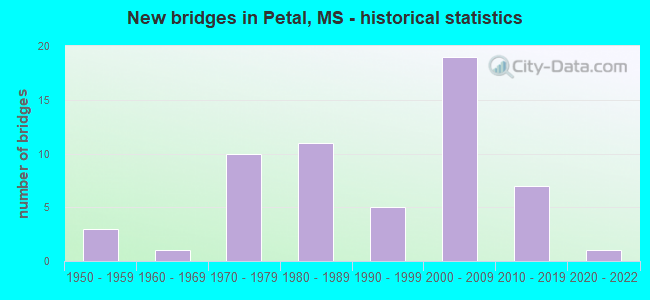
- New bridges - historical statistics
- 31950-1959
- 11960-1969
- 101970-1979
- 111980-1989
- 51990-1999
- 192000-2009
- 72010-2019
- 12020-2022


- Bridge Condition - Deck
- 14.3%Very good
- 54.8%Good
- 26.2%Satisfactory
- 4.8%Fair

- Bridge Condition - Superstructure
- 35.7%Very good
- 38.1%Good
- 21.4%Satisfactory
- 4.8%Fair

- Bridge Condition - Substructure
- 40.5%Very good
- 14.3%Good
- 35.7%Satisfactory
- 9.5%Fair

- Bridge Condition - Channel
- 7.5%Very good
- 49.1%Good
- 28.3%Satisfactory
- 15.1%Fair

- Bridge Condition - Culverts
- 7.7%Excellent
- 23.1%Very good
- 46.2%Good
- 23.1%Satisfactory
Find on map >> Show street view
Structure Number: 21000110180763, Location: 0.5 MI S SR 42 EAST (Lat: 31.342953, Lng: -89.280811), Route carried "on" structure: US 11, Year Built: 1978, Status: Open, Structure Length: 31.76m (104.20ft), Average Daily Traffic: 9,500 (year 2020), Truck Traffic: 6%, Average Future Daily Traffic: 9,500 (year 2040), Design Load: HS 20, Features Intersected: LEAF RIVER
Minimum Vertical Clearance: 30+ m (98+ ft), Kilometerpoint: 14.109, Lanes on structure: 4, Base Highway Network: Yes (Inventory Route: 1, Subroute: 1), Owner: State Highway Agency, Approaching Roadway Width: 25.9m (85.0ft), Skew: 10 degrees, Material/Design: Steel continuous, Design/Construction: Stringer/Multi-beam, Number Of Spans In Main Unit: 3, Number Of Approach Spans: 12, Length of Maximum Span: 54.9m (180.1ft), Curb-To-Curb Width: 21.5m (70.5ft), Out-to-Out Width: 26.0m (85.3ft)
Condition: Deck: Good, Superstructure: Good, Substructure: Good, Channel: Satisfactory, Operating Rating: 56.4 metric tons, Method Used To Determine Operating Rating: Load Factor (LF), Inventory Rating: 32.1 metric tons, Method Used To Determine Inventory Rating: Load Factor (LF), Structural Evaluation: Better than present minimum criteria, Deck Geometry: Superior to present desirable criteria, Waterway Adequacy: Equal to present desirable criteria, Approach Roadway Alignment: Equal to present desirable criteria, Designated Inspection Frequency: Every 24 months, Underwater Inspection Frequency: Every 60 months, Inspection Date: March 2020, Underwater Inspection Date: May 2019, Deck Structure Type: Concrete Cast-file-Place
Find on map >> Show street view
Structure Number: 2100011018078, Location: 0.3 MI N SR 42 (Lat: 31.362825, Lng: -89.269636), Route carried "on" structure: US 11, Year Built: 2013, Status: Open, Structure Length: 6.10m (20.01ft), Average Daily Traffic: 5,100 (year 2020), Truck Traffic: 14%, Average Future Daily Traffic: 5,100 (year 2040), Design Load: HL 93, Features Intersected: GREENS CREEK
Minimum Vertical Clearance: 30+ m (98+ ft), Kilometerpoint: 16.787, Lanes on structure: 4, Owner: State Highway Agency, Approaching Roadway Width: 24.4m (80.1ft), Material/Design: Prestressed concrete, Design/Construction: Stringer/Multi-beam, Number Of Spans In Main Unit: 5, Length of Maximum Span: 12.2m (40.0ft), Curb-To-Curb Width: 24.4m (80.1ft), Out-to-Out Width: 25.2m (82.7ft)
Condition: Deck: Good, Superstructure: Very good, Substructure: Very good, Channel: Good, Operating Rating: 44.2 metric tons, Method Used To Determine Operating Rating: Load and Resistance Factor (LRFR), Inventory Rating: 34.0 metric tons, Method Used To Determine Inventory Rating: Load and Resistance Factor (LRFR), Structural Evaluation: Equal to present desirable criteria, Deck Geometry: Superior to present desirable criteria, Waterway Adequacy: Equal to present desirable criteria, Approach Roadway Alignment: Equal to present desirable criteria, Designated Inspection Frequency: Every 24 months, Inspection Date: Febuary 2020, Deck Structure Type: Concrete Cast-file-Place
Find on map >> Show street view
Structure Number: 31000420180604A, Location: 0.8 MI W US 11 (Lat: 31.359617, Lng: -89.279853), Route carried "on" structure: State highway 42, Year Built: 2006, Status: Open, Structure Length: 43.50m (142.72ft), Average Daily Traffic: 8,000 (year 2020), Truck Traffic: 9%, Average Future Daily Traffic: 8,000 (year 2040), Design Load: HS 20, Features Intersected: LEAF RIVER
Minimum Vertical Clearance: 30+ m (98+ ft), Kilometerpoint: 10.107, Lanes on structure: 2, Base Highway Network: Yes (Inventory Route: 4, Subroute: 1), Owner: State Highway Agency, Approaching Roadway Width: 12.0m (39.4ft), Skew: 10 degrees, Material/Design: Steel continuous, Design/Construction: Stringer/Multi-beam, Number Of Spans In Main Unit: 3, Number Of Approach Spans: 16, Length of Maximum Span: 60.0m (196.9ft), Curb-To-Curb Width: 12.0m (39.4ft), Out-to-Out Width: 13.9m (45.6ft)
Condition: Deck: Good, Superstructure: Very good, Substructure: Very good, Channel: Good, Operating Rating: 69.2 metric tons, Method Used To Determine Operating Rating: Load Factor (LF), Inventory Rating: 36.3 metric tons, Method Used To Determine Inventory Rating: Load Factor (LF), Structural Evaluation: Equal to present desirable criteria, Deck Geometry: Better than present minimum criteria, Waterway Adequacy: Superior to present desirable criteria, Approach Roadway Alignment: Equal to present desirable criteria, Designated Inspection Frequency: Every 24 months, Inspection Date: Febuary 2020, Deck Structure Type: Concrete Cast-file-Place
Find on map >> Show street view
Structure Number: 31000420180604B, Location: 0.8 MI W US 11 (Lat: 31.359531, Lng: -89.284439), Route carried "on" structure: State highway 42, Year Built: 2006, Status: Open, Structure Length: 43.50m (142.72ft), Average Daily Traffic: 8,000 (year 2020), Truck Traffic: 9%, Average Future Daily Traffic: 8,000 (year 2040), Design Load: HS 20, Features Intersected: LEAF RIVER
Minimum Vertical Clearance: 30+ m (98+ ft), Kilometerpoint: 9.540, Lanes on structure: 2, Base Highway Network: Yes (Inventory Route: 4, Subroute: 2), Owner: State Highway Agency, Approaching Roadway Width: 12.0m (39.4ft), Skew: 10 degrees, Material/Design: Steel continuous, Design/Construction: Stringer/Multi-beam, Number Of Spans In Main Unit: 3, Number Of Approach Spans: 16, Length of Maximum Span: 60.0m (196.9ft), Curb-To-Curb Width: 12.0m (39.4ft), Out-to-Out Width: 13.9m (45.6ft)
Condition: Deck: Good, Superstructure: Very good, Substructure: Very good, Channel: Good, Operating Rating: 69.2 metric tons, Method Used To Determine Operating Rating: Load Factor (LF), Inventory Rating: 36.3 metric tons, Method Used To Determine Inventory Rating: Load Factor (LF), Structural Evaluation: Equal to present desirable criteria, Deck Geometry: Better than present minimum criteria, Waterway Adequacy: Superior to present desirable criteria, Approach Roadway Alignment: Equal to present desirable criteria, Designated Inspection Frequency: Every 24 months, Inspection Date: Febuary 2020, Deck Structure Type: Concrete Cast-file-Place
Find on map >> Show street view
Structure Number: 31000420180607A, Location: 0.5 MI W US 11 (Lat: 31.359533, Lng: -89.277025), Route carried "on" structure: State highway 42, Year Built: 2006, Status: Open, Structure Length: 15.00m (49.21ft), Average Daily Traffic: 8,000 (year 2020), Truck Traffic: 9%, Average Future Daily Traffic: 8,000 (year 2040), Design Load: HS 20, Features Intersected: GREENS CREEK
Minimum Vertical Clearance: 30+ m (98+ ft), Kilometerpoint: 9.838, Lanes on structure: 2, Base Highway Network: Yes (Inventory Route: 4, Subroute: 1), Owner: State Highway Agency, Approaching Roadway Width: 12.0m (39.4ft), Skew: 10 degrees, Material/Design: Prestressed concrete continuous, Design/Construction: Stringer/Multi-beam, Number Of Spans In Main Unit: 3, Number Of Approach Spans: 4, Length of Maximum Span: 30.0m (98.4ft), Curb-To-Curb Width: 12.0m (39.4ft), Out-to-Out Width: 13.9m (45.6ft)
Condition: Deck: Good, Superstructure: Very good, Substructure: Very good, Channel: Good, Operating Rating: 65.1 metric tons, Method Used To Determine Operating Rating: Load Factor (LF), Inventory Rating: 36.4 metric tons, Method Used To Determine Inventory Rating: Load Factor (LF), Structural Evaluation: Equal to present desirable criteria, Deck Geometry: Better than present minimum criteria, Waterway Adequacy: Superior to present desirable criteria, Approach Roadway Alignment: Equal to present desirable criteria, Designated Inspection Frequency: Every 24 months, Inspection Date: Febuary 2020, Deck Structure Type: Concrete Cast-file-Place
Find on map >> Show street view
Structure Number: 31000420180607B, Location: 0.5 MI W US 11 (Lat: 31.359342, Lng: -89.278606), Route carried "on" structure: State highway 42, Year Built: 2006, Status: Open, Structure Length: 15.00m (49.21ft), Average Daily Traffic: 8,000 (year 2020), Truck Traffic: 9%, Average Future Daily Traffic: 8,000 (year 2040), Design Load: HS 20, Features Intersected: GREENS CREEK
Minimum Vertical Clearance: 30+ m (98+ ft), Kilometerpoint: 10.095, Lanes on structure: 2, Base Highway Network: Yes (Inventory Route: 4, Subroute: 2), Owner: State Highway Agency, Approaching Roadway Width: 12.0m (39.4ft), Skew: 10 degrees, Material/Design: Prestressed concrete continuous, Design/Construction: Stringer/Multi-beam, Number Of Spans In Main Unit: 3, Number Of Approach Spans: 4, Length of Maximum Span: 30.0m (98.4ft), Curb-To-Curb Width: 12.0m (39.4ft), Out-to-Out Width: 13.9m (45.6ft)
Condition: Deck: Very good, Superstructure: Very good, Substructure: Very good, Channel: Good, Operating Rating: 65.1 metric tons, Method Used To Determine Operating Rating: Load Factor (LF), Inventory Rating: 36.4 metric tons, Method Used To Determine Inventory Rating: Load Factor (LF), Structural Evaluation: Equal to present desirable criteria, Deck Geometry: Better than present minimum criteria, Waterway Adequacy: Superior to present desirable criteria, Approach Roadway Alignment: Equal to present desirable criteria, Designated Inspection Frequency: Every 24 months, Inspection Date: Febuary 2020, Deck Structure Type: Concrete Cast-file-Place
Find on map >> Show street view
Structure Number: 31000420180612A, Location: SR 42 OVER US 11 & AGS RR (Lat: 31.359275, Lng: -89.269206), Route carried "on" structure: State highway 42, Year Built: 2006, Status: Open, Structure Length: 14.40m (47.24ft), Average Daily Traffic: 8,500 (year 2020), Truck Traffic: 6%, Average Future Daily Traffic: 8,500 (year 2040), Design Load: HS 20, Features Intersected: US 11 & AGS RR
Minimum Vertical Clearance: 30+ m (98+ ft), Kilometerpoint: 9.096, Lanes on structure: 2, Lanes under structure: 5, Base Highway Network: Yes (Inventory Route: 4, Subroute: 1), Owner: State Highway Agency, Approaching Roadway Width: 12.0m (39.4ft), Skew: 10 degrees, Material/Design: Prestressed concrete continuous, Design/Construction: Stringer/Multi-beam, Number Of Spans In Main Unit: 2, Number Of Approach Spans: 2, Length of Maximum Span: 42.0m (137.8ft), Curb-To-Curb Width: 12.0m (39.4ft), Out-to-Out Width: 13.9m (45.6ft)
Condition: Deck: Very good, Superstructure: Very good, Substructure: Very good, Operating Rating: 64.7 metric tons, Method Used To Determine Operating Rating: Load Factor (LF), Inventory Rating: 33.7 metric tons, Method Used To Determine Inventory Rating: Load Factor (LF), Structural Evaluation: Equal to present desirable criteria, Deck Geometry: Better than present minimum criteria, Underclear: Superior to present desirable criteria, Approach Roadway Alignment: Equal to present desirable criteria, Designated Inspection Frequency: Every 24 months, Inspection Date: Febuary 2020, Deck Structure Type: Concrete Cast-file-Place
Find on map >> Show street view
Structure Number: 31000420180612B, Location: SR 42 OVER US 11 & AGS RR (Lat: 31.359072, Lng: -89.270769), Route carried "on" structure: State highway 42, Year Built: 2006, Status: Open, Structure Length: 14.40m (47.24ft), Average Daily Traffic: 8,500 (year 2020), Truck Traffic: 6%, Average Future Daily Traffic: 8,500 (year 2040), Design Load: HS 20, Features Intersected: US 11 & AGS RR
Minimum Vertical Clearance: 30+ m (98+ ft), Kilometerpoint: 10.842, Lanes on structure: 2, Lanes under structure: 5, Base Highway Network: Yes (Inventory Route: 4, Subroute: 2), Owner: State Highway Agency, Approaching Roadway Width: 12.0m (39.4ft), Skew: 10 degrees, Material/Design: Prestressed concrete continuous, Design/Construction: Stringer/Multi-beam, Number Of Spans In Main Unit: 2, Number Of Approach Spans: 2, Length of Maximum Span: 42.0m (137.8ft), Curb-To-Curb Width: 12.0m (39.4ft), Out-to-Out Width: 13.9m (45.6ft)
Condition: Deck: Good, Superstructure: Very good, Substructure: Good, Operating Rating: 64.7 metric tons, Method Used To Determine Operating Rating: Load Factor (LF), Inventory Rating: 33.7 metric tons, Method Used To Determine Inventory Rating: Load Factor (LF), Structural Evaluation: Better than present minimum criteria, Deck Geometry: Better than present minimum criteria, Underclear: Superior to present desirable criteria, Approach Roadway Alignment: Equal to present desirable criteria, Designated Inspection Frequency: Every 24 months, Inspection Date: Febuary 2020, Deck Structure Type: Concrete Cast-file-Place
Find on map >> Show street view
Structure Number: 31000420180614A, Location: 0.2 MI E US 11 (Lat: 31.359158, Lng: -89.265989), Route carried "on" structure: State highway 42, Year Built: 2007, Status: Open, Structure Length: 10.57m (34.68ft), Average Daily Traffic: 8,500 (year 2020), Truck Traffic: 6%, Average Future Daily Traffic: 8,500 (year 2040), Design Load: HS 20, Features Intersected: GREENS CREEK
Minimum Vertical Clearance: 30+ m (98+ ft), Kilometerpoint: 8.789, Lanes on structure: 2, Base Highway Network: Yes (Inventory Route: 4, Subroute: 1), Owner: State Highway Agency, Approaching Roadway Width: 12.0m (39.4ft), Skew: 10 degrees, Material/Design: Prestressed concrete, Design/Construction: Stringer/Multi-beam, Number Of Spans In Main Unit: 1, Number Of Approach Spans: 5, Length of Maximum Span: 30.0m (98.4ft), Curb-To-Curb Width: 12.0m (39.4ft), Out-to-Out Width: 12.9m (42.3ft)
Condition: Deck: Good, Superstructure: Very good, Substructure: Very good, Channel: Satisfactory, Operating Rating: 66.5 metric tons, Method Used To Determine Operating Rating: Load Factor (LF), Inventory Rating: 34.9 metric tons, Method Used To Determine Inventory Rating: Load Factor (LF), Structural Evaluation: Equal to present desirable criteria, Deck Geometry: Better than present minimum criteria, Waterway Adequacy: Equal to present desirable criteria, Approach Roadway Alignment: Equal to present desirable criteria, Designated Inspection Frequency: Every 24 months, Inspection Date: Febuary 2020, Deck Structure Type: Concrete Cast-file-Place
Find on map >> Show street view
Structure Number: 31000420180614B, Location: 0.2 MI E US 11 (Lat: 31.358964, Lng: -89.267086), Route carried "on" structure: State highway 42, Year Built: 2007, Status: Open, Structure Length: 10.57m (34.68ft), Average Daily Traffic: 8,500 (year 2020), Truck Traffic: 6%, Average Future Daily Traffic: 8,500 (year 2040), Design Load: HS 20, Features Intersected: GREENS CREEK
Minimum Vertical Clearance: 30+ m (98+ ft), Kilometerpoint: 11.193, Lanes on structure: 2, Base Highway Network: Yes (Inventory Route: 4, Subroute: 2), Owner: State Highway Agency, Approaching Roadway Width: 12.0m (39.4ft), Skew: 10 degrees, Material/Design: Prestressed concrete, Design/Construction: Stringer/Multi-beam, Number Of Spans In Main Unit: 1, Number Of Approach Spans: 5, Length of Maximum Span: 30.0m (98.4ft), Curb-To-Curb Width: 12.0m (39.4ft), Out-to-Out Width: 12.9m (42.3ft)
Condition: Deck: Good, Superstructure: Very good, Substructure: Very good, Channel: Satisfactory, Operating Rating: 66.5 metric tons, Method Used To Determine Operating Rating: Load Factor (LF), Inventory Rating: 35.0 metric tons, Method Used To Determine Inventory Rating: Load Factor (LF), Structural Evaluation: Equal to present desirable criteria, Deck Geometry: Better than present minimum criteria, Waterway Adequacy: Equal to present desirable criteria, Approach Roadway Alignment: Equal to present desirable criteria, Designated Inspection Frequency: Every 24 months, Inspection Date: Febuary 2020, Deck Structure Type: Concrete Cast-file-Place
Find on map >> Show street view
Structure Number: 31000420180621A, Location: 0.9 MI E US 11 (Lat: 31.355517, Lng: -89.255439), Route carried "on" structure: State highway 42, Year Built: 2007, Status: Open, Structure Length: 7.57m (24.84ft), Average Daily Traffic: 8,500 (year 2020), Truck Traffic: 6%, Average Future Daily Traffic: 8,500 (year 2040), Design Load: HS 20, Features Intersected: GREENS CREEK
Minimum Vertical Clearance: 30+ m (98+ ft), Kilometerpoint: 7.694, Lanes on structure: 2, Base Highway Network: Yes (Inventory Route: 4, Subroute: 1), Owner: State Highway Agency, Approaching Roadway Width: 12.0m (39.4ft), Skew: 10 degrees, Material/Design: Prestressed concrete, Design/Construction: Stringer/Multi-beam, Number Of Spans In Main Unit: 1, Number Of Approach Spans: 3, Length of Maximum Span: 29.8m (97.8ft), Curb-To-Curb Width: 12.0m (39.4ft), Out-to-Out Width: 12.9m (42.3ft)
Condition: Deck: Very good, Superstructure: Very good, Substructure: Very good, Channel: Good, Operating Rating: 67.3 metric tons, Method Used To Determine Operating Rating: Load Factor (LF), Inventory Rating: 36.0 metric tons, Method Used To Determine Inventory Rating: Load Factor (LF), Structural Evaluation: Equal to present desirable criteria, Deck Geometry: Better than present minimum criteria, Waterway Adequacy: Equal to present desirable criteria, Approach Roadway Alignment: Equal to present desirable criteria, Designated Inspection Frequency: Every 24 months, Inspection Date: Febuary 2020, Deck Structure Type: Concrete Cast-file-Place
Find on map >> Show street view
Structure Number: 31000420180621B, Location: 0.9 MI E US 11 (Lat: 31.355589, Lng: -89.256161), Route carried "on" structure: State highway 42, Year Built: 2007, Status: Open, Structure Length: 7.57m (24.84ft), Average Daily Traffic: 8,500 (year 2020), Truck Traffic: 6%, Average Future Daily Traffic: 8,500 (year 2040), Design Load: HS 20, Features Intersected: GREENS CREEK
Minimum Vertical Clearance: 30+ m (98+ ft), Kilometerpoint: 12.315, Lanes on structure: 2, Base Highway Network: Yes (Inventory Route: 4, Subroute: 2), Owner: State Highway Agency, Approaching Roadway Width: 12.0m (39.4ft), Skew: 10 degrees, Material/Design: Prestressed concrete, Design/Construction: Stringer/Multi-beam, Number Of Spans In Main Unit: 1, Number Of Approach Spans: 3, Length of Maximum Span: 29.8m (97.8ft), Curb-To-Curb Width: 12.0m (39.4ft), Out-to-Out Width: 12.9m (42.3ft)
Condition: Deck: Very good, Superstructure: Very good, Substructure: Very good, Channel: Good, Operating Rating: 67.3 metric tons, Method Used To Determine Operating Rating: Load Factor (LF), Inventory Rating: 36.0 metric tons, Method Used To Determine Inventory Rating: Load Factor (LF), Structural Evaluation: Equal to present desirable criteria, Deck Geometry: Better than present minimum criteria, Waterway Adequacy: Equal to present desirable criteria, Approach Roadway Alignment: Equal to present desirable criteria, Designated Inspection Frequency: Every 24 months, Inspection Date: Febuary 2020, Deck Structure Type: Concrete Cast-file-Place
Find on map >> Show street view
Structure Number: 31000420180631, Location: 1.9 MI E US 11 (Lat: 31.351283, Lng: -89.239253), Route carried "on" structure: State highway 42, Year Built: 2007, Status: Open, Structure Length: 0.72m (2.36ft), Average Daily Traffic: 17,000 (year 2020), Truck Traffic: 5%, Average Future Daily Traffic: 17,000 (year 2040), Design Load: HS 20+Mod, Features Intersected: DRY PRONG CREEK TRIB
Minimum Vertical Clearance: 30+ m (98+ ft), Kilometerpoint: 14.016, Lanes on structure: 4, Base Highway Network: Yes (Inventory Route: 4, Subroute: 2), Owner: State Highway Agency, Approaching Roadway Width: 21.6m (70.9ft), Skew: 14 degrees, Material/Design: Concrete, Design/Construction: Culvert, Number Of Spans In Main Unit: 2, Length of Maximum Span: 2.7m (8.9ft)
Condition: Channel: Good, Culverts: Good, Structural Evaluation: Better than present minimum criteria, Waterway Adequacy: Equal to present desirable criteria, Approach Roadway Alignment: Equal to present desirable criteria, Designated Inspection Frequency: Every 24 months, Inspection Date: Febuary 2020
Find on map >> Show street view
Structure Number: 31000420180636, Location: 2.3 MI E US 11 (Lat: 31.350425, Lng: -89.232936), Route carried "on" structure: State highway 42, Year Built: 2007, Status: Open, Structure Length: 1.01m (3.31ft), Average Daily Traffic: 15,000 (year 2020), Truck Traffic: 4%, Average Future Daily Traffic: 15,000 (year 2040), Design Load: HS 20+Mod, Features Intersected: DRY PRONG CREEK
Minimum Vertical Clearance: 30+ m (98+ ft), Kilometerpoint: 14.624, Lanes on structure: 4, Base Highway Network: Yes (Inventory Route: 4, Subroute: 2), Owner: State Highway Agency, Approaching Roadway Width: 21.6m (70.9ft), Skew: 10 degrees, Material/Design: Concrete, Design/Construction: Culvert, Number Of Spans In Main Unit: 2, Length of Maximum Span: 5.2m (17.1ft)
Condition: Channel: Good, Culverts: Satisfactory, Structural Evaluation: Equal to present minimum criteria, Waterway Adequacy: Equal to present desirable criteria, Approach Roadway Alignment: Equal to present desirable criteria, Designated Inspection Frequency: Every 24 months, Inspection Date: Febuary 2020
Find on map >> Show street view
Structure Number: 31000420180666, Location: 5.5 MI E US 11 (Lat: 31.351150, Lng: -89.179219), Route carried "on" structure: State highway 42, Year Built: 1951, Status: Open, Structure Length: 0.80m (2.62ft), Average Daily Traffic: 15,000 (year 2020), Truck Traffic: 4%, Average Future Daily Traffic: 15,000 (year 2040), Design Load: H 15, Features Intersected: REESE CREEK
Minimum Vertical Clearance: 30+ m (98+ ft), Kilometerpoint: 19.742, Lanes on structure: 2, Base Highway Network: Yes (Inventory Route: 4, Subroute: 2), Owner: State Highway Agency, Approaching Roadway Width: 14.0m (45.9ft), Material/Design: Concrete, Design/Construction: Culvert, Number Of Spans In Main Unit: 2, Length of Maximum Span: 4.0m (13.1ft)
Condition: Channel: Satisfactory, Culverts: Good, Operating Rating: 40.3 metric tons, Method Used To Determine Operating Rating: Load Factor (LF), Inventory Rating: 24.1 metric tons, Method Used To Determine Inventory Rating: Load Factor (LF), Structural Evaluation: Somewhat better than minimum adequacy, Waterway Adequacy: Equal to present desirable criteria, Approach Roadway Alignment: Equal to present desirable criteria, Length Of Structure Improvement: 0.82m (2.69ft), Designated Inspection Frequency: Every 24 months, Inspection Date: Febuary 2020, Bridge Improvement Cost: $52,000,000, Roadway Improvement Cost: $200,000,000, Total Project Cost: $300,000,000
Find on map >> Show street view
Structure Number: SA1800000000001, Location: SEC 2 T 1N R12W (Lat: 31.073828, Lng: -89.167167), Route carried "on" structure: County highway 194, Year Built: 1970, Status: Posted for load, Structure Length: 2.90m (9.51ft), Average Daily Traffic: 100 (year 2018), Average Future Daily Traffic: 150 (year 2038), Design Load: H 15, Features Intersected: POPLAR CREEK, Facility Carried by Structure: GRAPEVINE ROAD
Minimum Vertical Clearance: 30+ m (98+ ft), Kilometerpoint: 0.804, Lanes on structure: 2, Owner: County Highway Agency, Approaching Roadway Width: 6.2m (20.3ft), Material/Design: Concrete, Design/Construction: Slab, Number Of Spans In Main Unit: 5, Length of Maximum Span: 5.8m (19.0ft), Curb or Sidewalk Widths: Left: 0.4m (1.3ft), Right: 0.4m (1.3ft), Curb-To-Curb Width: 6.7m (22.0ft), Out-to-Out Width: 7.5m (24.6ft)
Condition: Deck: Satisfactory, Superstructure: Satisfactory, Substructure: Satisfactory, Channel: Fair, Operating Rating: 25.0 metric tons, Method Used To Determine Operating Rating: Load Factor (LF), Inventory Rating: 15.0 metric tons, Method Used To Determine Inventory Rating: Load Factor (LF), Structural Evaluation: Meets minimum limits, Deck Geometry: Somewhat better than minimum adequacy, Waterway Adequacy: Equal to present desirable criteria, Approach Roadway Alignment: Better than present minimum criteria, Bridge Posting: Required (Relationship of Operating Rating to Maximum Legal Load: 30.0 - 39.9% below), Length Of Structure Improvement: 3.47m (11.38ft), Designated Inspection Frequency: Every 24 months, Inspection Date: October 2020, Bridge Improvement Cost: $208,000, Roadway Improvement Cost: $21,000, Total Project Cost: $256,000 ( Estimate for 2016), Deck Structure Type: Concrete Cast-file-Place, Wearing Surface/Protective System: Wearing Surface: Monolithic Concrete
Find on map >> Show street view
Structure Number: SA1800000000085, Location: SEC 2 T 4N R12W (Lat: 31.345900, Lng: -89.172242), Route carried "on" structure: County highway 128, Year Built: 1978, Status: Posted for load, Structure Length: 1.16m (3.81ft), Average Daily Traffic: 200 (year 2021), Truck Traffic: 8%, Average Future Daily Traffic: 300 (year 2041), Design Load: H 15, Features Intersected: REESE CREEK, Facility Carried by Structure: TEMPLE ROAD
Minimum Vertical Clearance: 30+ m (98+ ft), Kilometerpoint: 0.804, Lanes on structure: 2, Owner: County Highway Agency, Approaching Roadway Width: 6.1m (20.0ft), Material/Design: Concrete, Design/Construction: Channel Beam, Number Of Spans In Main Unit: 2, Length of Maximum Span: 5.8m (19.0ft), Curb or Sidewalk Widths: Left: 0.2m (0.7ft), Right: 0.2m (0.7ft), Curb-To-Curb Width: 7.1m (23.3ft), Out-to-Out Width: 7.5m (24.6ft)
Condition: Deck: Good, Superstructure: Good, Substructure: Satisfactory, Channel: Good, Operating Rating: 31.2 metric tons, Method Used To Determine Operating Rating: Allowable Stress (AS), Inventory Rating: 23.4 metric tons, Method Used To Determine Inventory Rating: Allowable Stress (AS), Structural Evaluation: Equal to present minimum criteria, Deck Geometry: Meets minimum limits, Waterway Adequacy: Equal to present desirable criteria, Approach Roadway Alignment: Equal to present desirable criteria, Bridge Posting: Required (Relationship of Operating Rating to Maximum Legal Load: 10.0 - 19.9% below), Length Of Structure Improvement: 1.74m (5.71ft), Designated Inspection Frequency: Every 12 months, Inspection Date: October 2021, Bridge Improvement Cost: $55,000, Roadway Improvement Cost: $25,000, Total Project Cost: $89,000 ( Estimate for 2016), Deck Structure Type: Concrete Precast Panels, Wearing Surface/Protective System: Wearing Surface: Bituminous
Find on map >> Show street view
Structure Number: SA1800000000086, Location: SEC 2 T 4N R12W (Lat: 31.338161, Lng: -89.172194), Route carried "on" structure: City street 360, Year Built: 1984, Status: Open, Structure Length: 1.74m (5.71ft), Average Daily Traffic: 100 (year 2020), Average Future Daily Traffic: 150 (year 2040), Design Load: H 15, Features Intersected: REESE CREEK, Facility Carried by Structure: COUNTRY PARK DR
Minimum Vertical Clearance: 30+ m (98+ ft), Kilometerpoint: 0.804, Lanes on structure: 2, Owner: County Highway Agency, Approaching Roadway Width: 6.1m (20.0ft), Material/Design: Concrete, Design/Construction: Channel Beam, Number Of Spans In Main Unit: 3, Length of Maximum Span: 5.8m (19.0ft), Curb or Sidewalk Widths: Left: 0.2m (0.7ft), Right: 0.2m (0.7ft), Curb-To-Curb Width: 7.1m (23.3ft), Out-to-Out Width: 7.5m (24.6ft)
Condition: Deck: Fair, Superstructure: Fair, Substructure: Satisfactory, Channel: Fair, Operating Rating: 42.6 metric tons, Method Used To Determine Operating Rating: Allowable Stress (AS), Inventory Rating: 32.1 metric tons, Method Used To Determine Inventory Rating: Allowable Stress (AS), Structural Evaluation: Somewhat better than minimum adequacy, Deck Geometry: Somewhat better than minimum adequacy, Waterway Adequacy: Equal to present desirable criteria, Approach Roadway Alignment: Equal to present desirable criteria, Length Of Structure Improvement: 2.31m (7.58ft), Designated Inspection Frequency: Every 24 months, Inspection Date: October 2020, Bridge Improvement Cost: $74,000, Roadway Improvement Cost: $30,000, Total Project Cost: $115,000 ( Estimate for 2016), Deck Structure Type: Concrete Precast Panels, Wearing Surface/Protective System: Wearing Surface: Monolithic Concrete
Find on map >> Show street view
Structure Number: SA1800000000087, Location: SEC 8 T 4N R12W (Lat: 31.319833, Lng: -89.228767), Route carried "on" structure: County highway , Year Built: 1976, Status: Posted for load, Structure Length: 3.47m (11.38ft), Average Daily Traffic: 100 (year 2021), Average Future Daily Traffic: 150 (year 2041), Design Load: H 15, Features Intersected: DRY PRONG CREEK, Facility Carried by Structure: DAVIS ROAD
Minimum Vertical Clearance: 30+ m (98+ ft), Kilometerpoint: 0.321, Lanes on structure: 2, Owner: County Highway Agency, Approaching Roadway Width: 5.2m (17.1ft), Material/Design: Concrete, Design/Construction: Channel Beam, Number Of Spans In Main Unit: 6, Length of Maximum Span: 5.8m (19.0ft), Curb or Sidewalk Widths: Left: 0.2m (0.7ft), Right: 0.2m (0.7ft), Curb-To-Curb Width: 7.1m (23.3ft), Out-to-Out Width: 7.5m (24.6ft)
Condition: Deck: Satisfactory, Superstructure: Satisfactory, Substructure: Satisfactory, Channel: Good, Operating Rating: 14.1 metric tons, Method Used To Determine Operating Rating: Allowable Stress (AS), Inventory Rating: 10.6 metric tons, Method Used To Determine Inventory Rating: Allowable Stress (AS), Structural Evaluation: High priority of replacement, Deck Geometry: Somewhat better than minimum adequacy, Waterway Adequacy: Equal to present desirable criteria, Approach Roadway Alignment: Equal to present minimum criteria, Bridge Posting: Required (Relationship of Operating Rating to Maximum Legal Load: > 39.9% below), Length Of Structure Improvement: 3.72m (12.20ft), Designated Inspection Frequency: Every 24 months, Inspection Date: October 2020, Bridge Improvement Cost: $222,000, Roadway Improvement Cost: $25,000, Total Project Cost: $276,000 ( Estimate for 2018), Deck Structure Type: Concrete Precast Panels, Wearing Surface/Protective System: Wearing Surface: Bituminous
Find on map >> Show street view
Structure Number: SA1800000000088, Location: SEC 9 T 4N R12W (Lat: 31.318914, Lng: -89.211722), Route carried "on" structure: County highway 76, Year Built: 1977, Status: Open, Structure Length: 3.47m (11.38ft), Average Daily Traffic: 180 (year 2020), Truck Traffic: 8%, Average Future Daily Traffic: 270 (year 2040), Design Load: H 15, Features Intersected: LOTTS CREEK, Facility Carried by Structure: DAVIS ROAD
Minimum Vertical Clearance: 30+ m (98+ ft), Kilometerpoint: 0.482, Lanes on structure: 2, Owner: County Highway Agency, Approaching Roadway Width: 5.8m (19.0ft), Material/Design: Concrete, Design/Construction: Channel Beam, Number Of Spans In Main Unit: 6, Length of Maximum Span: 5.8m (19.0ft), Curb or Sidewalk Widths: Left: 0.2m (0.7ft), Right: 0.2m (0.7ft), Curb-To-Curb Width: 7.1m (23.3ft), Out-to-Out Width: 7.5m (24.6ft)
Condition: Deck: Satisfactory, Superstructure: Satisfactory, Substructure: Satisfactory, Channel: Good, Operating Rating: 52.6 metric tons, Method Used To Determine Operating Rating: Load Factor (LF), Inventory Rating: 31.5 metric tons, Method Used To Determine Inventory Rating: Load Factor (LF), Structural Evaluation: Equal to present minimum criteria, Deck Geometry: Meets minimum limits, Waterway Adequacy: Equal to present desirable criteria, Approach Roadway Alignment: Equal to present desirable criteria, Length Of Structure Improvement: 3.66m (12.01ft), Designated Inspection Frequency: Every 24 months, Inspection Date: October 2020, Bridge Improvement Cost: $149,000, Roadway Improvement Cost: $20,000, Total Project Cost: $188,000 ( Estimate for 2016), Deck Structure Type: Concrete Precast Panels, Wearing Surface/Protective System: Wearing Surface: Bituminous
Find on map >> Show street view
Structure Number: SA1800000000089, Location: SEC 11 T 4N R12W B (Lat: 31.327958, Lng: -89.170394), Route carried "on" structure: County highway , Year Built: 1981, Status: Open, Structure Length: 3.47m (11.38ft), Average Daily Traffic: 320 (year 2018), Truck Traffic: 8%, Average Future Daily Traffic: 480 (year 2038), Design Load: HS 20, Features Intersected: REESE CREEK, Facility Carried by Structure: GOODLUCK ROAD
Minimum Vertical Clearance: 30+ m (98+ ft), Kilometerpoint: 0.965, Lanes on structure: 2, Owner: County Highway Agency, Approaching Roadway Width: 6.7m (22.0ft), Material/Design: Concrete, Design/Construction: Slab, Number Of Spans In Main Unit: 6, Length of Maximum Span: 5.8m (19.0ft), Curb or Sidewalk Widths: Left: 0.5m (1.6ft), Right: 0.5m (1.6ft), Curb-To-Curb Width: 8.5m (27.9ft), Out-to-Out Width: 9.5m (31.2ft)
Condition: Deck: Satisfactory, Superstructure: Satisfactory, Substructure: Satisfactory, Channel: Satisfactory, Operating Rating: 70.9 metric tons, Method Used To Determine Operating Rating: Load Factor (LF), Inventory Rating: 42.5 metric tons, Method Used To Determine Inventory Rating: Load Factor (LF), Structural Evaluation: Equal to present minimum criteria, Deck Geometry: Equal to present minimum criteria, Waterway Adequacy: Equal to present desirable criteria, Approach Roadway Alignment: Equal to present minimum criteria, Designated Inspection Frequency: Every 24 months, Inspection Date: December 2020, Deck Structure Type: Concrete Cast-file-Place, Wearing Surface/Protective System: Wearing Surface: Monolithic Concrete
Find on map >> Show street view
Structure Number: SA180000000009, Location: SEC 11 T 4N R12W (Lat: 31.322897, Lng: -89.178161), Route carried "on" structure: County highway 614, Year Built: 1978, Status: Open, Structure Length: 1.16m (3.81ft), Average Daily Traffic: 420 (year 2020), Truck Traffic: 8%, Average Future Daily Traffic: 630 (year 2040), Design Load: H 15, Features Intersected: PRINT CARTER CREEK, Facility Carried by Structure: CARTER CUT-OFF RD
Minimum Vertical Clearance: 30+ m (98+ ft), Kilometerpoint: 5.471, Lanes on structure: 2, Owner: County Highway Agency, Approaching Roadway Width: 5.9m (19.4ft), Material/Design: Concrete, Design/Construction: Channel Beam, Number Of Spans In Main Unit: 2, Length of Maximum Span: 5.8m (19.0ft), Curb or Sidewalk Widths: Left: 0.2m (0.7ft), Right: 0.2m (0.7ft), Curb-To-Curb Width: 7.1m (23.3ft), Out-to-Out Width: 7.6m (24.9ft)
Condition: Deck: Satisfactory, Superstructure: Satisfactory, Substructure: Satisfactory, Channel: Good, Operating Rating: 54.9 metric tons, Method Used To Determine Operating Rating: Load Factor (LF), Inventory Rating: 32.9 metric tons, Method Used To Determine Inventory Rating: Load Factor (LF), Structural Evaluation: Equal to present minimum criteria, Deck Geometry: Meets minimum limits, Waterway Adequacy: Better than present minimum criteria, Approach Roadway Alignment: Equal to present minimum criteria, Length Of Structure Improvement: 1.74m (5.71ft), Designated Inspection Frequency: Every 24 months, Inspection Date: October 2020, Bridge Improvement Cost: $62,000, Roadway Improvement Cost: $20,000, Total Project Cost: $91,000 ( Estimate for 2016), Deck Structure Type: Concrete Precast Panels, Wearing Surface/Protective System: Wearing Surface: Monolithic Concrete
Find on map >> Show street view
Structure Number: SA1800000000091, Location: SEC 13 T 4N R12W B (Lat: 31.309528, Lng: -89.155144), Route carried "on" structure: County highway 133, Year Built: 1986, Status: Open, Structure Length: 3.99m (13.09ft), Average Daily Traffic: 80 (year 2020), Average Future Daily Traffic: 120 (year 2040), Design Load: H 15, Features Intersected: REESE CREEK, Facility Carried by Structure: BURGER ROAD
Minimum Vertical Clearance: 30+ m (98+ ft), Kilometerpoint: 0.321, Lanes on structure: 2, Owner: County Highway Agency, Approaching Roadway Width: 6.1m (20.0ft), Material/Design: Concrete, Design/Construction: Channel Beam, Number Of Spans In Main Unit: 5, Length of Maximum Span: 9.4m (30.8ft), Curb or Sidewalk Widths: Left: 0.2m (0.7ft), Right: 0.2m (0.7ft), Curb-To-Curb Width: 8.1m (26.6ft), Out-to-Out Width: 8.5m (27.9ft)
Condition: Deck: Good, Superstructure: Good, Substructure: Satisfactory, Channel: Satisfactory, Operating Rating: 48.2 metric tons, Method Used To Determine Operating Rating: Load Factor (LF), Inventory Rating: 28.8 metric tons, Method Used To Determine Inventory Rating: Load Factor (LF), Structural Evaluation: Equal to present minimum criteria, Deck Geometry: Equal to present minimum criteria, Waterway Adequacy: Equal to present desirable criteria, Approach Roadway Alignment: Equal to present desirable criteria, Designated Inspection Frequency: Every 24 months, Inspection Date: October 2020, Deck Structure Type: Concrete Precast Panels, Wearing Surface/Protective System: Wearing Surface: Bituminous
Find on map >> Show street view
Structure Number: SA1800000000092, Location: SEC 17 T 4N R12W (Lat: 31.312622, Lng: -89.222000), Route carried "on" structure: County highway 77, Year Built: 1968, Status: Open, Structure Length: 3.47m (11.38ft), Average Daily Traffic: 280 (year 2020), Truck Traffic: 8%, Average Future Daily Traffic: 420 (year 2040), Design Load: H 15, Features Intersected: LOTTS CREEK, Facility Carried by Structure: FORREST BARNES RD
Minimum Vertical Clearance: 30+ m (98+ ft), Kilometerpoint: 0.160, Lanes on structure: 2, Owner: County Highway Agency, Approaching Roadway Width: 6.1m (20.0ft), Material/Design: Concrete, Design/Construction: Channel Beam, Number Of Spans In Main Unit: 6, Length of Maximum Span: 5.8m (19.0ft), Curb or Sidewalk Widths: Left: 0.2m (0.7ft), Right: 0.2m (0.7ft), Curb-To-Curb Width: 7.1m (23.3ft), Out-to-Out Width: 7.5m (24.6ft)
Condition: Deck: Satisfactory, Superstructure: Satisfactory, Substructure: Satisfactory, Channel: Satisfactory, Operating Rating: 41.3 metric tons, Method Used To Determine Operating Rating: Allowable Stress (AS), Inventory Rating: 31.1 metric tons, Method Used To Determine Inventory Rating: Allowable Stress (AS), Structural Evaluation: Equal to present minimum criteria, Deck Geometry: Meets minimum limits, Waterway Adequacy: Equal to present desirable criteria, Approach Roadway Alignment: Equal to present desirable criteria, Length Of Structure Improvement: 3.72m (12.20ft), Designated Inspection Frequency: Every 24 months, Inspection Date: October 2020, Bridge Improvement Cost: $222,000, Roadway Improvement Cost: $25,000, Total Project Cost: $276,000 ( Estimate for 2016), Deck Structure Type: Concrete Precast Panels, Wearing Surface/Protective System: Wearing Surface: Monolithic Concrete
Find on map >> Show street view
Structure Number: SA1800000000094, Location: SEC 18 T 4N R12W B (Lat: 31.310550, Lng: -89.237131), Route carried "on" structure: City street 7189, Year Built: 1959, Status: Posted for load, Structure Length: 3.66m (12.01ft), Average Daily Traffic: 5,000 (year 2020), Truck Traffic: 8%, Average Future Daily Traffic: 7,500 (year 2040), Design Load: H 15, Features Intersected: LOTTS CREEK, Facility Carried by Structure: SUNRISE ROAD
Minimum Vertical Clearance: 30+ m (98+ ft), Kilometerpoint: 12.874, Lanes on structure: 2, Owner: City or Municipal Highway Agency, Approaching Roadway Width: 6.1m (20.0ft), Material/Design: Steel, Design/Construction: Stringer/Multi-beam, Number Of Spans In Main Unit: 3, Length of Maximum Span: 12.2m (40.0ft), Curb or Sidewalk Widths: Left: 0.3m (1.0ft), Right: 0.3m (1.0ft), Curb-To-Curb Width: 6.7m (22.0ft), Out-to-Out Width: 7.3m (24.0ft)
Condition: Deck: Fair, Superstructure: Good, Substructure: Satisfactory, Channel: Satisfactory, Operating Rating: 32.6 metric tons, Method Used To Determine Operating Rating: Load Factor (LF), Inventory Rating: 19.6 metric tons, Method Used To Determine Inventory Rating: Load Factor (LF), Structural Evaluation: Somewhat better than minimum adequacy, Deck Geometry: High priority of replacement, Waterway Adequacy: Equal to present desirable criteria, Approach Roadway Alignment: Better than present minimum criteria, Bridge Posting: Required (Relationship of Operating Rating to Maximum Legal Load: 10.0 - 19.9% below), Length Of Structure Improvement: 4.27m (14.01ft), Designated Inspection Frequency: Every 24 months, Inspection Date: October 2020, Bridge Improvement Cost: $174,000, Roadway Improvement Cost: $50,000, Total Project Cost: $249,000 ( Estimate for 2016), Deck Structure Type: Concrete Cast-file-Place, Wearing Surface/Protective System: Wearing Surface: Monolithic Concrete
Find on map >> Show street view
Structure Number: SA1800000000107, Location: SEC 2 T 4N R13W (Lat: 31.333175, Lng: -89.267167), Route carried "on" structure: City street 8782, Year Built: 1985, Status: Posted for load, Structure Length: 0.94m (3.08ft), Average Daily Traffic: 1,300 (year 2021), Truck Traffic: 8%, Average Future Daily Traffic: 1,430 (year 2041), Design Load: H 15, Features Intersected: MATTHEWS BRANCH, Facility Carried by Structure: GEORGE STREET
Minimum Vertical Clearance: 30+ m (98+ ft), Kilometerpoint: 1.448, Lanes on structure: 2, Owner: City or Municipal Highway Agency, Approaching Roadway Width: 5.7m (18.7ft), Material/Design: Concrete, Design/Construction: Channel Beam, Number Of Spans In Main Unit: 1, Length of Maximum Span: 9.4m (30.8ft), Curb or Sidewalk Widths: Left: 0.2m (0.7ft), Right: 0.2m (0.7ft), Curb-To-Curb Width: 8.2m (26.9ft), Out-to-Out Width: 8.6m (28.2ft)
Condition: Deck: Satisfactory, Superstructure: Satisfactory, Substructure: Fair, Channel: Good, Operating Rating: 35.0 metric tons, Method Used To Determine Operating Rating: Load Factor (LF) rating reported by rating factor (RF) method using MS18 loading, Inventory Rating: 21.1 metric tons, Method Used To Determine Inventory Rating: Load Factor (LF) rating reported by rating factor (RF) method using MS18 loading, Structural Evaluation: Somewhat better than minimum adequacy, Deck Geometry: Meets minimum limits, Waterway Adequacy: Equal to present desirable criteria, Approach Roadway Alignment: Equal to present desirable criteria, Length Of Structure Improvement: 2.10m (6.89ft), Designated Inspection Frequency: Every 12 months, Inspection Date: October 2021, Bridge Improvement Cost: $125,000, Roadway Improvement Cost: $15,000, Total Project Cost: $156,000 ( Estimate for 2016), Deck Structure Type: Concrete Precast Panels, Wearing Surface/Protective System: Wearing Surface: Monolithic Concrete
Find on map >> Show street view
Structure Number: SA1800000000131, Location: SEC 11 T 4N R13W (Lat: 31.326636, Lng: -89.267175), Route carried "on" structure: City street 8790, Year Built: 1950, Status: Posted for load, Structure Length: 28.04m (91.99ft), Average Daily Traffic: 10,000 (year 2019), Truck Traffic: 10%, Average Future Daily Traffic: 11,000 (year 2039), Design Load: H 15, Features Intersected: LEAF RIVER, Facility Carried by Structure: EAST HARDY STREET
Minimum Vertical Clearance: 30+ m (98+ ft), Kilometerpoint: 0.000, Lanes on structure: 2, Owner: City or Municipal Highway Agency, Approaching Roadway Width: 13.7m (44.9ft), Material/Design: Steel, Design/Construction: Truss - Thru, Number Of Spans In Main Unit: 2, Number Of Approach Spans: 18, Length of Maximum Span: 48.8m (160.1ft), Curb or Sidewalk Widths: Left: 0.9m (3.0ft), Right: 0.9m (3.0ft), Curb-To-Curb Width: 7.9m (25.9ft), Out-to-Out Width: 9.7m (31.8ft)
Condition: Deck: Satisfactory, Superstructure: Fair, Substructure: Fair, Channel: Satisfactory, Operating Rating: 17.8 metric tons, Method Used To Determine Operating Rating: Load Factor (LF) rating reported by rating factor (RF) method using MS18 loading, Inventory Rating: 10.7 metric tons, Method Used To Determine Inventory Rating: Load Factor (LF) rating reported by rating factor (RF) method using MS18 loading, Structural Evaluation: High priority of replacement, Deck Geometry: High priority of corrective action, Waterway Adequacy: Equal to present desirable criteria, Approach Roadway Alignment: Equal to present desirable criteria, Bridge Posting: Required (Relationship of Operating Rating to Maximum Legal Load: 30.0 - 39.9% below), Length Of Structure Improvement: 32.92m (108.01ft), Designated Inspection Frequency: Every 24 months, Critical Feature Inspection Frequency: Every 24 months, Underwater Inspection Frequency: Every 60 months, Inspection Date: November 2019, Critical Feature Inspection Date: November 2019, Underwater Inspection Date: August 2020, Bridge Improvement Cost: $1,736,000, Roadway Improvement Cost: $200,000, Total Project Cost: $2,149,000 ( Estimate for 2016), Deck Structure Type: Concrete Cast-file-Place, Wearing Surface/Protective System: Wearing Surface: Monolithic Concrete
Find on map >> Show street view
Structure Number: SA1800000000182, Location: SEC 11 T 5N R12W B (Lat: 31.410689, Lng: -89.168931), Route carried "on" structure: County highway 222, Year Built: 2002, Status: Open, Structure Length: 2.10m (6.89ft), Average Daily Traffic: 830 (year 2021), Truck Traffic: 8%, Average Future Daily Traffic: 1,245 (year 2041), Design Load: HS 20, Features Intersected: GILLIS CREEK, Facility Carried by Structure: MACEDONIA ROAD
Minimum Vertical Clearance: 30+ m (98+ ft), Kilometerpoint: 17.219, Lanes on structure: 2, Owner: County Highway Agency, Approaching Roadway Width: 7.3m (24.0ft), Material/Design: Concrete, Design/Construction: Channel Beam, Number Of Spans In Main Unit: 3, Length of Maximum Span: 9.4m (30.8ft), Curb or Sidewalk Widths: Left: 0.5m (1.6ft), Right: 0.5m (1.6ft), Curb-To-Curb Width: 9.1m (29.9ft), Out-to-Out Width: 10.1m (33.1ft)
Condition: Deck: Good, Superstructure: Good, Substructure: Very good, Channel: Good, Operating Rating: 59.8 metric tons, Method Used To Determine Operating Rating: Load Factor (LF), Inventory Rating: 36.0 metric tons, Method Used To Determine Inventory Rating: Load Factor (LF), Structural Evaluation: Better than present minimum criteria, Deck Geometry: Equal to present minimum criteria, Waterway Adequacy: Equal to present desirable criteria, Approach Roadway Alignment: Equal to present desirable criteria, Designated Inspection Frequency: Every 24 months, Inspection Date: December 2021, Deck Structure Type: Concrete Precast Panels, Wearing Surface/Protective System: Wearing Surface: Monolithic Concrete
Find on map >> Show street view
Structure Number: SA1800000000183, Location: SEC 11 T 5N R12W (Lat: 31.408528, Lng: -89.173611), Route carried "on" structure: County highway 55, Year Built: 1983, Status: Open, Structure Length: 1.74m (5.71ft), Average Daily Traffic: 440 (year 2020), Truck Traffic: 8%, Average Future Daily Traffic: 660 (year 2040), Design Load: H 15, Features Intersected: GILLIS CREEK, Facility Carried by Structure: WALTERS ROAD
Minimum Vertical Clearance: 30+ m (98+ ft), Kilometerpoint: 2.414, Lanes on structure: 2, Owner: County Highway Agency, Approaching Roadway Width: 6.1m (20.0ft), Material/Design: Concrete, Design/Construction: Channel Beam, Number Of Spans In Main Unit: 3, Length of Maximum Span: 5.8m (19.0ft), Curb or Sidewalk Widths: Left: 0.2m (0.7ft), Right: 0.2m (0.7ft), Curb-To-Curb Width: 8.2m (26.9ft), Out-to-Out Width: 8.6m (28.2ft)
Condition: Deck: Good, Superstructure: Good, Substructure: Satisfactory, Channel: Satisfactory, Operating Rating: 37.3 metric tons, Method Used To Determine Operating Rating: Allowable Stress (AS), Inventory Rating: 28.0 metric tons, Method Used To Determine Inventory Rating: Allowable Stress (AS), Structural Evaluation: Equal to present minimum criteria, Deck Geometry: Somewhat better than minimum adequacy, Waterway Adequacy: Equal to present desirable criteria, Approach Roadway Alignment: Equal to present desirable criteria, Length Of Structure Improvement: 2.38m (7.81ft), Designated Inspection Frequency: Every 24 months, Inspection Date: October 2020, Bridge Improvement Cost: $142,000, Roadway Improvement Cost: $15,000, Total Project Cost: $175,000 ( Estimate for 2016), Deck Structure Type: Concrete Precast Panels, Wearing Surface/Protective System: Wearing Surface: Bituminous
Find on map >> Show street view
Structure Number: SA1800000000184, Location: SEC 17 T 5N R12W (Lat: 31.395558, Lng: -89.220689), Route carried "on" structure: County highway 39, Year Built: 1991, Status: Open, Structure Length: 2.10m (6.89ft), Average Daily Traffic: 430 (year 2020), Truck Traffic: 8%, Average Future Daily Traffic: 630 (year 2040), Design Load: HS 20, Features Intersected: GREENS CREEK, Facility Carried by Structure: ROBERTSON ROAD
Minimum Vertical Clearance: 30+ m (98+ ft), Kilometerpoint: 6.437, Lanes on structure: 2, Owner: County Highway Agency, Approaching Roadway Width: 6.7m (22.0ft), Material/Design: Concrete, Design/Construction: Channel Beam, Number Of Spans In Main Unit: 3, Length of Maximum Span: 9.4m (30.8ft), Curb or Sidewalk Widths: Left: 0.2m (0.7ft), Right: 0.2m (0.7ft), Curb-To-Curb Width: 9.1m (29.9ft), Out-to-Out Width: 9.5m (31.2ft)
Condition: Deck: Good, Superstructure: Good, Substructure: Good, Channel: Fair, Operating Rating: 59.3 metric tons, Method Used To Determine Operating Rating: Load Factor (LF) rating reported by rating factor (RF) method using MS18 loading, Inventory Rating: 35.6 metric tons, Method Used To Determine Inventory Rating: Load Factor (LF) rating reported by rating factor (RF) method using MS18 loading, Structural Evaluation: Better than present minimum criteria, Deck Geometry: Equal to present minimum criteria, Waterway Adequacy: Equal to present desirable criteria, Approach Roadway Alignment: Equal to present desirable criteria, Designated Inspection Frequency: Every 24 months, Inspection Date: December 2020, Deck Structure Type: Concrete Precast Panels, Wearing Surface/Protective System: Wearing Surface: Monolithic Concrete
Find on map >> Show street view
Structure Number: SA1800000000185, Location: SEC 21 T 5N R12W B (Lat: 31.384819, Lng: -89.198067), Route carried "on" structure: County highway 613, Year Built: 1988, Status: Open, Structure Length: 1.74m (5.71ft), Average Daily Traffic: 3,200 (year 2018), Truck Traffic: 8%, Average Future Daily Traffic: 4,800 (year 2038), Design Load: HS 20, Features Intersected: THIRD CREEK, Facility Carried by Structure: OLD RICHTON ROAD
Minimum Vertical Clearance: 30+ m (98+ ft), Kilometerpoint: 10.299, Lanes on structure: 2, Owner: County Highway Agency, Approaching Roadway Width: 7.9m (25.9ft), Material/Design: Concrete, Design/Construction: Channel Beam, Number Of Spans In Main Unit: 3, Length of Maximum Span: 5.8m (19.0ft), Curb or Sidewalk Widths: Left: 0.5m (1.6ft), Right: 0.5m (1.6ft), Curb-To-Curb Width: 8.5m (27.9ft), Out-to-Out Width: 9.5m (31.2ft)
Condition: Deck: Good, Superstructure: Good, Substructure: Very good, Channel: Good, Operating Rating: 89.2 metric tons, Method Used To Determine Operating Rating: Load Factor (LF), Inventory Rating: 53.6 metric tons, Method Used To Determine Inventory Rating: Load Factor (LF), Structural Evaluation: Better than present minimum criteria, Deck Geometry: Meets minimum limits, Waterway Adequacy: Equal to present desirable criteria, Approach Roadway Alignment: Equal to present desirable criteria, Designated Inspection Frequency: Every 24 months, Inspection Date: January 2020, Deck Structure Type: Concrete Precast Panels, Wearing Surface/Protective System: Wearing Surface: Monolithic Concrete
Find on map >> Show street view
Structure Number: SA1800000000186, Location: SEC 23 T 5N R12W B (Lat: 31.382539, Lng: -89.167581), Route carried "on" structure: County highway 613, Year Built: 1982, Status: Open, Structure Length: 0.67m (2.20ft), Average Daily Traffic: 480 (year 2018), Truck Traffic: 8%, Average Future Daily Traffic: 720 (year 2038), Design Load: HS 20, Features Intersected: MCWILLIAMS BRANCH, Facility Carried by Structure: OLD RICHTON ROAD
Minimum Vertical Clearance: 30+ m (98+ ft), Kilometerpoint: 13.196, Lanes on structure: 2, Owner: County Highway Agency, Approaching Roadway Width: 6.7m (22.0ft), Material/Design: Concrete, Design/Construction: Culvert, Number Of Spans In Main Unit: 2, Length of Maximum Span: 3.0m (9.8ft)
Condition: Channel: Fair, Culverts: Good, Operating Rating: 54.6 metric tons, Method Used To Determine Operating Rating: Load Factor (LF), Inventory Rating: 32.7 metric tons, Method Used To Determine Inventory Rating: Load Factor (LF), Structural Evaluation: Better than present minimum criteria, Waterway Adequacy: Equal to present desirable criteria, Approach Roadway Alignment: Equal to present desirable criteria, Designated Inspection Frequency: Every 24 months, Inspection Date: January 2020
Find on map >> Show street view
Structure Number: SA1800000000187, Location: SEC 26 T 5N R12W B (Lat: 31.370286, Lng: -89.163331), Route carried "on" structure: County highway 222, Year Built: 1974, Status: Posted for load, Structure Length: 1.74m (5.71ft), Average Daily Traffic: 700 (year 2021), Truck Traffic: 8%, Average Future Daily Traffic: 770 (year 2041), Design Load: H 15, Features Intersected: THIRD CREEK, Facility Carried by Structure: MACEDONIA ROAD
Minimum Vertical Clearance: 30+ m (98+ ft), Kilometerpoint: 12.070, Lanes on structure: 2, Owner: County Highway Agency, Approaching Roadway Width: 6.2m (20.3ft), Material/Design: Concrete, Design/Construction: Channel Beam, Number Of Spans In Main Unit: 3, Length of Maximum Span: 5.8m (19.0ft), Curb or Sidewalk Widths: Left: 0.2m (0.7ft), Right: 0.2m (0.7ft), Curb-To-Curb Width: 7.1m (23.3ft), Out-to-Out Width: 7.6m (24.9ft)
Condition: Deck: Satisfactory, Superstructure: Satisfactory, Substructure: Fair, Channel: Good, Operating Rating: 51.3 metric tons, Method Used To Determine Operating Rating: Load Factor (LF), Inventory Rating: 30.7 metric tons, Method Used To Determine Inventory Rating: Load Factor (LF), Structural Evaluation: Somewhat better than minimum adequacy, Deck Geometry: Meets minimum limits, Waterway Adequacy: Equal to present desirable criteria, Approach Roadway Alignment: Equal to present desirable criteria, Length Of Structure Improvement: 3.11m (10.20ft), Designated Inspection Frequency: Every 12 months, Inspection Date: October 2021, Bridge Improvement Cost: $185,000, Roadway Improvement Cost: $20,000, Total Project Cost: $230,000 ( Estimate for 2015), Deck Structure Type: Concrete Precast Panels, Wearing Surface/Protective System: Wearing Surface: Bituminous
Find on map >> Show street view
Structure Number: SA1800000000188, Location: SEC 29 T 5N R12W (Lat: 31.367064, Lng: -89.226150), Route carried "on" structure: County highway 67, Year Built: 1983, Status: Open, Structure Length: 1.16m (3.81ft), Average Daily Traffic: 940 (year 2020), Truck Traffic: 8%, Average Future Daily Traffic: 1,410 (year 2040), Design Load: H 15, Features Intersected: DRY PRONG CREEK, Facility Carried by Structure: SPRINGFIELD ROAD
Minimum Vertical Clearance: 30+ m (98+ ft), Kilometerpoint: 1.770, Lanes on structure: 2, Owner: County Highway Agency, Approaching Roadway Width: 5.7m (18.7ft), Material/Design: Concrete, Design/Construction: Channel Beam, Number Of Spans In Main Unit: 2, Length of Maximum Span: 5.8m (19.0ft), Curb or Sidewalk Widths: Left: 0.2m (0.7ft), Right: 0.2m (0.7ft), Curb-To-Curb Width: 8.2m (26.9ft), Out-to-Out Width: 8.6m (28.2ft)
Condition: Deck: Good, Superstructure: Good, Substructure: Satisfactory, Channel: Fair, Operating Rating: 40.0 metric tons, Method Used To Determine Operating Rating: Allowable Stress (AS), Inventory Rating: 27.4 metric tons, Method Used To Determine Inventory Rating: Allowable Stress (AS), Structural Evaluation: Equal to present minimum criteria, Deck Geometry: Somewhat better than minimum adequacy, Waterway Adequacy: Better than present minimum criteria, Approach Roadway Alignment: Equal to present desirable criteria, Length Of Structure Improvement: 2.10m (6.89ft), Designated Inspection Frequency: Every 24 months, Inspection Date: October 2020, Bridge Improvement Cost: $125,000, Roadway Improvement Cost: $15,000, Total Project Cost: $156,000 ( Estimate for 2016), Deck Structure Type: Concrete Precast Panels, Wearing Surface/Protective System: Wearing Surface: Monolithic Concrete
Find on map >> Show street view
Structure Number: SA1800000000189, Location: SEC 30 T 5N R12W (Lat: 31.370433, Lng: -89.234292), Route carried "on" structure: City street 41, Year Built: 2010, Status: Open, Structure Length: 2.10m (6.89ft), Average Daily Traffic: 580 (year 2020), Truck Traffic: 8%, Average Future Daily Traffic: 870 (year 2040), Design Load: HL 93, Features Intersected: GREENS CREEK, Facility Carried by Structure: KELLY ROSE LANE
Minimum Vertical Clearance: 30+ m (98+ ft), Kilometerpoint: 6.437, Lanes on structure: 2, Owner: City or Municipal Highway Agency, Approaching Roadway Width: 6.7m (22.0ft), Material/Design: Concrete, Design/Construction: Channel Beam, Number Of Spans In Main Unit: 3, Length of Maximum Span: 9.4m (30.8ft), Curb or Sidewalk Widths: Left: 0.5m (1.6ft), Right: 0.5m (1.6ft), Curb-To-Curb Width: 8.5m (27.9ft), Out-to-Out Width: 9.5m (31.2ft)
Condition: Deck: Good, Superstructure: Good, Substructure: Good, Channel: Good, Operating Rating: 43.7 metric tons, Method Used To Determine Operating Rating: Load and Resistance Factor Rating (LRFR) rating reported by rating factor(RF) method using HL-93 loadings, Inventory Rating: 33.7 metric tons, Method Used To Determine Inventory Rating: Load and Resistance Factor Rating (LRFR) rating reported by rating factor(RF) method using HL-93 loadings, Structural Evaluation: Better than present minimum criteria, Deck Geometry: Somewhat better than minimum adequacy, Waterway Adequacy: Equal to present desirable criteria, Approach Roadway Alignment: Equal to present desirable criteria, Designated Inspection Frequency: Every 24 months, Inspection Date: December 2020, Deck Structure Type: Concrete Precast Panels, Wearing Surface/Protective System: Wearing Surface: Monolithic Concrete
Find on map >> Show street view
Structure Number: SA1800000000192, Location: SEC 2 T 5N R13W (Lat: 31.421664, Lng: -89.279128), Route carried "on" structure: County highway 629, Year Built: 1990, Status: Open, Structure Length: 2.10m (6.89ft), Average Daily Traffic: 260 (year 2018), Truck Traffic: 8%, Average Future Daily Traffic: 390 (year 2038), Design Load: HS 20, Features Intersected: BRANCH OF LEAF RIVER, Facility Carried by Structure: LEEVILLE ROAD
Minimum Vertical Clearance: 30+ m (98+ ft), Kilometerpoint: 9.656, Lanes on structure: 2, Owner: County Highway Agency, Approaching Roadway Width: 6.7m (22.0ft), Material/Design: Concrete, Design/Construction: Channel Beam, Number Of Spans In Main Unit: 3, Length of Maximum Span: 9.4m (30.8ft), Curb or Sidewalk Widths: Left: 0.2m (0.7ft), Right: 0.2m (0.7ft), Curb-To-Curb Width: 8.1m (26.6ft), Out-to-Out Width: 8.5m (27.9ft)
Condition: Deck: Good, Superstructure: Good, Substructure: Good, Channel: Very good, Operating Rating: 75.5 metric tons, Method Used To Determine Operating Rating: Load Factor (LF), Inventory Rating: 45.4 metric tons, Method Used To Determine Inventory Rating: Load Factor (LF), Structural Evaluation: Better than present minimum criteria, Deck Geometry: Somewhat better than minimum adequacy, Waterway Adequacy: Equal to present desirable criteria, Approach Roadway Alignment: Equal to present desirable criteria, Designated Inspection Frequency: Every 24 months, Inspection Date: January 2020, Deck Structure Type: Concrete Precast Panels, Wearing Surface/Protective System: Wearing Surface: Monolithic Concrete
Find on map >> Show street view
Structure Number: SA1800000000194, Location: SEC 11 T 5N R13W (Lat: 31.410494, Lng: -89.275597), Route carried "on" structure: County highway 629, Year Built: 1989, Status: Open, Structure Length: 1.74m (5.71ft), Average Daily Traffic: 260 (year 2018), Truck Traffic: 8%, Average Future Daily Traffic: 390 (year 2038), Design Load: HS 20, Features Intersected: BRANCH OF LEAF RIVER, Facility Carried by Structure: LEEVILLE ROAD
Minimum Vertical Clearance: 30+ m (98+ ft), Kilometerpoint: 8.690, Lanes on structure: 2, Owner: County Highway Agency, Approaching Roadway Width: 6.7m (22.0ft), Material/Design: Concrete, Design/Construction: Channel Beam, Number Of Spans In Main Unit: 3, Length of Maximum Span: 5.8m (19.0ft), Curb or Sidewalk Widths: Left: 0.2m (0.7ft), Right: 0.2m (0.7ft), Curb-To-Curb Width: 8.1m (26.6ft), Out-to-Out Width: 8.5m (27.9ft)
Condition: Deck: Good, Superstructure: Good, Substructure: Good, Channel: Good, Operating Rating: 90.2 metric tons, Method Used To Determine Operating Rating: Load Factor (LF), Inventory Rating: 53.9 metric tons, Method Used To Determine Inventory Rating: Load Factor (LF), Structural Evaluation: Better than present minimum criteria, Deck Geometry: Somewhat better than minimum adequacy, Waterway Adequacy: Equal to present desirable criteria, Approach Roadway Alignment: Equal to present desirable criteria, Designated Inspection Frequency: Every 24 months, Inspection Date: January 2020, Deck Structure Type: Concrete Precast Panels, Wearing Surface/Protective System: Wearing Surface: Monolithic Concrete
Find on map >> Show street view
Structure Number: SA1800000000195, Location: SEC 11 T 5N R13W (Lat: 31.418528, Lng: -89.278278), Route carried "on" structure: County highway 620, Year Built: 1986, Status: Open, Structure Length: 1.16m (3.81ft), Average Daily Traffic: 390 (year 2021), Truck Traffic: 8%, Average Future Daily Traffic: 429 (year 2041), Design Load: H 15, Features Intersected: BRANCH OF LEAF RIVER, Facility Carried by Structure: LEEVILLE ROAD
Minimum Vertical Clearance: 30+ m (98+ ft), Kilometerpoint: 9.334, Lanes on structure: 2, Owner: County Highway Agency, Approaching Roadway Width: 6.1m (20.0ft), Material/Design: Concrete, Design/Construction: Channel Beam, Number Of Spans In Main Unit: 2, Length of Maximum Span: 5.8m (19.0ft), Curb or Sidewalk Widths: Left: 0.2m (0.7ft), Right: 0.2m (0.7ft), Curb-To-Curb Width: 7.1m (23.3ft), Out-to-Out Width: 7.5m (24.6ft)
Condition: Deck: Good, Superstructure: Good, Substructure: Satisfactory, Channel: Good, Operating Rating: 54.1 metric tons, Method Used To Determine Operating Rating: Load Factor (LF) rating reported by rating factor (RF) method using MS18 loading, Inventory Rating: 32.4 metric tons, Method Used To Determine Inventory Rating: Load Factor (LF) rating reported by rating factor (RF) method using MS18 loading, Structural Evaluation: Equal to present minimum criteria, Deck Geometry: Meets minimum limits, Waterway Adequacy: Equal to present desirable criteria, Approach Roadway Alignment: Equal to present minimum criteria, Length Of Structure Improvement: 2.38m (7.81ft), Designated Inspection Frequency: Every 24 months, Inspection Date: October 2021, Bridge Improvement Cost: $142,000, Roadway Improvement Cost: $15,000, Total Project Cost: $175,000 ( Estimate for 2015), Deck Structure Type: Concrete Precast Panels, Wearing Surface/Protective System: Wearing Surface: Monolithic Concrete
Find on map >> Show street view
Structure Number: SA1800000000196, Location: SEC_13_T 5N_R13W B (Lat: 31.393667, Lng: -89.247933), Route carried "on" structure: County highway 41, Year Built: 1994, Status: Open, Structure Length: 1.74m (5.71ft), Average Daily Traffic: 260 (year 2018), Truck Traffic: 8%, Average Future Daily Traffic: 390 (year 2038), Design Load: HS 20, Features Intersected: BOGGY BRANCH, Facility Carried by Structure: OTIS LEE ROAD
Minimum Vertical Clearance: 30+ m (98+ ft), Kilometerpoint: 0.000, Lanes on structure: 2, Owner: County Highway Agency, Approaching Roadway Width: 6.1m (20.0ft), Material/Design: Concrete, Design/Construction: Channel Beam, Number Of Spans In Main Unit: 3, Length of Maximum Span: 5.8m (19.0ft), Curb or Sidewalk Widths: Left: 0.5m (1.6ft), Right: 0.5m (1.6ft), Curb-To-Curb Width: 8.5m (27.9ft), Out-to-Out Width: 9.1m (29.9ft)
Condition: Deck: Good, Superstructure: Very good, Substructure: Very good, Channel: Good, Operating Rating: 89.2 metric tons, Method Used To Determine Operating Rating: Load Factor (LF), Inventory Rating: 53.6 metric tons, Method Used To Determine Inventory Rating: Load Factor (LF), Structural Evaluation: Equal to present desirable criteria, Deck Geometry: Equal to present minimum criteria, Waterway Adequacy: Equal to present desirable criteria, Approach Roadway Alignment: Equal to present desirable criteria, Designated Inspection Frequency: Every 24 months, Inspection Date: January 2020, Deck Structure Type: Concrete Precast Panels, Wearing Surface/Protective System: Wearing Surface: Monolithic Concrete
Find on map >> Show street view
Structure Number: SA1800000000198, Location: SEC 25 T 5N R13W B (Lat: 31.363575, Lng: -89.255975), Route carried "on" structure: City street 39, Year Built: 1979, Status: Open, Structure Length: 1.74m (5.71ft), Average Daily Traffic: 660 (year 2020), Truck Traffic: 8%, Average Future Daily Traffic: 990 (year 2040), Design Load: H 15, Features Intersected: BOGGY BRANCH, Facility Carried by Structure: LYNN RAY ROAD
Minimum Vertical Clearance: 30+ m (98+ ft), Kilometerpoint: 0.321, Lanes on structure: 2, Owner: City or Municipal Highway Agency, Approaching Roadway Width: 6.4m (21.0ft), Material/Design: Concrete, Design/Construction: Channel Beam, Number Of Spans In Main Unit: 3, Length of Maximum Span: 5.8m (19.0ft), Curb or Sidewalk Widths: Left: 0.2m (0.7ft), Right: 0.2m (0.7ft), Curb-To-Curb Width: 8.1m (26.6ft), Out-to-Out Width: 8.6m (28.2ft)
Condition: Deck: Satisfactory, Superstructure: Satisfactory, Substructure: Satisfactory, Channel: Satisfactory, Operating Rating: 45.9 metric tons, Method Used To Determine Operating Rating: Load Factor (LF), Inventory Rating: 27.4 metric tons, Method Used To Determine Inventory Rating: Load Factor (LF), Structural Evaluation: Equal to present minimum criteria, Deck Geometry: Somewhat better than minimum adequacy, Waterway Adequacy: Equal to present desirable criteria, Approach Roadway Alignment: Equal to present desirable criteria, Length Of Structure Improvement: 2.38m (7.81ft), Designated Inspection Frequency: Every 24 months, Inspection Date: October 2020, Bridge Improvement Cost: $142,000, Roadway Improvement Cost: $15,000, Total Project Cost: $175,000 ( Estimate for 2018), Deck Structure Type: Concrete Precast Panels, Wearing Surface/Protective System: Wearing Surface: Monolithic Concrete