Bridge Statistics for Paterson, New Jersey (NJ)
Condition, Traffic, Stress, Structural Evaluation, Project Costs
- National Bridge Inventory (NBI) Statistics
- 105Number of bridges
- 1,253ft / 382mTotal length
- $34,714,000Total costs
- 2,714,776Total average daily traffic
- 171,944Total average daily truck traffic
- National Bridge Inventory (NBI) Registered Bridges for Paterson
- No street view available for this location
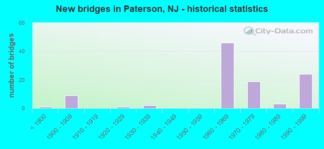
- New bridges - historical statistics
- 1Before 1900
- 91900-1909
- 11920-1929
- 21930-1939
- 461960-1969
- 191970-1979
- 31980-1989
- 241990-1999

- Reconstructed bridges - Historical Statistics
- 11960-1969
- 01970-1979
- 71980-1989
- 31990-1999
- 12000-2009
- 12010-2019


- Bridge Condition - Deck
- 2.0%Very good
- 30.6%Good
- 34.7%Satisfactory
- 30.6%Fair
- 2.0%Poor

- Bridge Condition - Superstructure
- 3.8%Very good
- 48.1%Good
- 19.2%Satisfactory
- 26.9%Fair
- 1.9%Serious

- Bridge Condition - Substructure
- 38.5%Good
- 44.2%Satisfactory
- 15.4%Fair
- 1.9%Poor

- Bridge Condition - Channel
- 21.7%Very good
- 43.5%Good
- 21.7%Satisfactory
- 8.7%Fair
- 4.3%Poor
Find on map >> Show street view
Structure Number: 1600002, Location: 0.1 MI. EAST OF RT.21 JCT (Lat: 40.854169, Lng: -74.119981), Route carried "on" structure: City street , Year Built: 1906, Year Reconstructed: 1989, Status: Open, Structure Length: 7.47m (24.51ft), Average Daily Traffic: 28,038 (year 2021), Truck Traffic: 4%, Average Future Daily Traffic: 34,212 (year 2041), Design Load: H 20, Features Intersected: PASSAIC RIVER, Facility Carried by Structure: GREGORY AVENUE
Minimum Vertical Clearance: 3.66m (12.01ft), Kilometerpoint: 2.430, Lanes on structure: 2, Owner: County Highway Agency, Approaching Roadway Width: 10.4m (34.1ft), Material/Design: Steel, Design/Construction: Truss - Thru, Number Of Spans In Main Unit: 2, Length of Maximum Span: 33.2m (108.9ft), Curb or Sidewalk Widths: Left: 2.4m (7.9ft), Right: 2.4m (7.9ft), Curb-To-Curb Width: 8.8m (28.9ft), Out-to-Out Width: 9.3m (30.5ft)
Condition: Deck: Good, Superstructure: Good, Substructure: Satisfactory, Channel: Good, Operating Rating: 39.9 metric tons, Method Used To Determine Operating Rating: Load Factor (LF), Inventory Rating: 23.6 metric tons, Method Used To Determine Inventory Rating: Load Factor (LF), Structural Evaluation: Somewhat better than minimum adequacy, Deck Geometry: High priority of corrective action, Waterway Adequacy: Equal to present desirable criteria, Approach Roadway Alignment: Equal to present minimum criteria, Length Of Structure Improvement: 7.47m (24.51ft), Designated Inspection Frequency: Every 24 months, Critical Feature Inspection Frequency: Every 24 months, Underwater Inspection Frequency: Every 48 months, Inspection Date: May 2021, Critical Feature Inspection Date: May 2021, Underwater Inspection Date: June 2019, Bridge Improvement Cost: $56,000, Roadway Improvement Cost: $6,000, Total Project Cost: $78,000 ( Estimate for 2021), Deck Structure Type: Concrete Cast-file-Place, Wearing Surface/Protective System: Wearing Surface: Monolithic Concrete
Find on map >> Show street view
Structure Number: 1600009, Location: EAST OF JCT RT 20 (Lat: 40.933789, Lng: -74.140011), Route carried "on" structure: City street , Year Built: 1905, Year Reconstructed: 1967, Status: Closed, Structure Length: 8.23m (27.00ft), Average Daily Traffic: 2,237 (year 2021), Average Future Daily Traffic: 2,730 (year 2041), Features Intersected: PASSAIC RIVER, Facility Carried by Structure: FIFTH AVENUE
Minimum Vertical Clearance: 4.91m (16.11ft), Kilometerpoint: 0.000, Lanes on structure: 2, Owner: County Highway Agency, Approaching Roadway Width: 12.2m (40.0ft), Skew: 1 degrees, Material/Design: Steel, Design/Construction: Truss - Thru, Number Of Spans In Main Unit: 2, Length of Maximum Span: 40.8m (133.9ft), Curb or Sidewalk Widths: Left: 0.0m, Right: 1.8m (5.9ft), Curb-To-Curb Width: 5.9m (19.4ft), Out-to-Out Width: 6.2m (20.3ft)
Condition: Deck: Satisfactory, Superstructure: Serious, Substructure: Poor, Channel: Satisfactory, Operating Rating: 12.7 metric tons, Method Used To Determine Operating Rating: Load Factor (LF), Inventory Rating: 7.3 metric tons, Method Used To Determine Inventory Rating: Load Factor (LF), Waterway Adequacy: Equal to present desirable criteria, Approach Roadway Alignment: Equal to present minimum criteria, Bridge Posting: Required (Relationship of Operating Rating to Maximum Legal Load: > 39.9% below), Length Of Structure Improvement: 9.05m (29.69ft), Designated Inspection Frequency: Every 24 months, Critical Feature Inspection Frequency: Every 24 months, Other Special Inspection Frequency: Every 12 months, Inspection Date: March 2021, Critical Feature Inspection Date: March 2021, Other Special Inspection Date: May 2020, Bridge Improvement Cost: $5,601,000, Roadway Improvement Cost: $112,000, Total Project Cost: $9,175,000 ( Estimate for 2021), Deck Structure Type: Open Grating, Wearing Surface/Protective System: Wearing Surface: Other
Find on map >> Show street view
Structure Number: 160001, Location: AT JCT. OF ROUTE 20 (Lat: 40.940431, Lng: -74.144200), Route carried "on" structure: City street , Year Built: 1907, Year Reconstructed: 1992, Status: Open, Structure Length: 9.91m (32.51ft), Average Daily Traffic: 22,366 (year 2021), Truck Traffic: 4%, Average Future Daily Traffic: 27,290 (year 2041), Features Intersected: PASSAIC RIVER, Facility Carried by Structure: MAPLE AVE
Minimum Vertical Clearance: 30+ m (98+ ft), Kilometerpoint: 0.080, Lanes on structure: 3, Base Highway Network: Yes, Owner: County Highway Agency, Approaching Roadway Width: 9.1m (29.9ft), Material/Design: Concrete, Design/Construction: Arch - Deck, Number Of Spans In Main Unit: 3, Length of Maximum Span: 32.6m (107.0ft), Curb or Sidewalk Widths: Left: 1.5m (4.9ft), Right: 0.0m, Curb-To-Curb Width: 9.8m (32.2ft), Out-to-Out Width: 12.1m (39.7ft)
Condition: Superstructure: Satisfactory, Substructure: Good, Channel: Good, Operating Rating: 84.4 metric tons, Method Used To Determine Operating Rating: Allowable Stress (AS), Inventory Rating: 33.6 metric tons, Method Used To Determine Inventory Rating: Allowable Stress (AS), Structural Evaluation: Equal to present minimum criteria, Deck Geometry: High priority of replacement, Waterway Adequacy: Equal to present desirable criteria, Approach Roadway Alignment: Meets minimum limits, Length Of Structure Improvement: 9.91m (32.51ft), Designated Inspection Frequency: Every 24 months, Inspection Date: March 2021, Bridge Improvement Cost: $1,021,000, Roadway Improvement Cost: $102,000, Total Project Cost: $1,405,000 ( Estimate for 2021)
Find on map >> Show street view
Structure Number: 1600011, Location: 1.20 MI SW OF JCT. RT 208 (Lat: 40.942139, Lng: -74.148239), Route carried "on" structure: County highway 504, Year Built: 1926, Year Reconstructed: 1993, Status: Open, Structure Length: 11.89m (39.01ft), Average Daily Traffic: 16,220 (year 2021), Truck Traffic: 4%, Average Future Daily Traffic: 21,850 (year 2041), Design Load: HS 25 or greater, Features Intersected: PASSAIC RIVER
Minimum Vertical Clearance: 30+ m (98+ ft), Kilometerpoint: 25.395, Lanes on structure: 3, Owner: County Highway Agency, Approaching Roadway Width: 11.6m (38.1ft), Material/Design: Steel continuous, Design/Construction: Stringer/Multi-beam, Number Of Spans In Main Unit: 6, Length of Maximum Span: 19.8m (65.0ft), Curb or Sidewalk Widths: Left: 1.8m (5.9ft), Right: 0.0m, Curb-To-Curb Width: 11.6m (38.1ft), Out-to-Out Width: 14.3m (46.9ft)
Condition: Deck: Good, Superstructure: Good, Substructure: Satisfactory, Channel: Good, Inventory Rating: 58.1 metric tons, Method Used To Determine Inventory Rating: Load Factor (LF), Structural Evaluation: Equal to present minimum criteria, Deck Geometry: High priority of replacement, Waterway Adequacy: Equal to present desirable criteria, Approach Roadway Alignment: Equal to present minimum criteria, Length Of Structure Improvement: 11.89m (39.01ft), Designated Inspection Frequency: Every 24 months, Inspection Date: March 2021, Bridge Improvement Cost: $137,000, Roadway Improvement Cost: $20,000, Total Project Cost: $220,000 ( Estimate for 2021), Deck Structure Type: Concrete Cast-file-Place, Wearing Surface/Protective System: Wearing Surface: Monolithic Concrete, Deck Protection: Epoxy Coated Reinforcing
Find on map >> Show street view
Structure Number: 1600012, Location: 0.4 NE OF HALEDON ST(504) (Lat: 40.934231, Lng: -74.167250), Route carried "on" structure: County highway 652, Year Built: 1900, Year Reconstructed: 1987, Status: Open, Structure Length: 9.14m (29.99ft), Average Daily Traffic: 11,534 (year 2021), Truck Traffic: 4%, Average Future Daily Traffic: 14,074 (year 2041), Features Intersected: PASSAIC RIVER
Minimum Vertical Clearance: 30+ m (98+ ft), Kilometerpoint: 0.724, Lanes on structure: 2, Owner: County Highway Agency, Approaching Roadway Width: 7.9m (25.9ft), Skew: 2 degrees, Material/Design: Steel continuous, Design/Construction: Truss - Thru, Number Of Spans In Main Unit: 4, Length of Maximum Span: 25.9m (85.0ft), Curb or Sidewalk Widths: Left: 1.5m (4.9ft), Right: 0.0m, Curb-To-Curb Width: 7.2m (23.6ft), Out-to-Out Width: 7.6m (24.9ft)
Condition: Deck: Good, Superstructure: Fair, Substructure: Fair, Channel: Good, Operating Rating: 47.2 metric tons, Method Used To Determine Operating Rating: Load Factor (LF), Inventory Rating: 28.1 metric tons, Method Used To Determine Inventory Rating: Load Factor (LF), Structural Evaluation: Somewhat better than minimum adequacy, Deck Geometry: High priority of replacement, Waterway Adequacy: Equal to present desirable criteria, Approach Roadway Alignment: Somewhat better than minimum adequacy, Length Of Structure Improvement: 10.06m (33.01ft), Designated Inspection Frequency: Every 24 months, Critical Feature Inspection Frequency: Every 24 months, Underwater Inspection Frequency: Every 24 months, Inspection Date: May 2021, Critical Feature Inspection Date: May 2021, Underwater Inspection Date: June 2021, Bridge Improvement Cost: $6,223,000, Roadway Improvement Cost: $225,000, Total Project Cost: $9,899,000 ( Estimate for 2021), Deck Structure Type: Open Grating, Wearing Surface/Protective System: Wearing Surface: Other
Find on map >> Show street view
Structure Number: 1600014, Location: 0.5 MI N OF BROADWAY (Lat: 40.926031, Lng: -74.165769), Route carried "on" structure: City street , Year Built: 1907, Year Reconstructed: 2003, Status: Open, Structure Length: 7.77m (25.49ft), Average Daily Traffic: 25,206 (year 2021), Truck Traffic: 1%, Average Future Daily Traffic: 30,756 (year 2041), Features Intersected: PASSAIC RIVER, Facility Carried by Structure: STRAIGHT STREET
Minimum Vertical Clearance: 5.33m (17.49ft), Kilometerpoint: 0.000, Lanes on structure: 2, Owner: County Highway Agency, Approaching Roadway Width: 9.1m (29.9ft), Material/Design: Steel, Design/Construction: Truss - Thru, Number Of Spans In Main Unit: 1, Length of Maximum Span: 76.5m (251.0ft), Curb or Sidewalk Widths: Left: 2.3m (7.5ft), Right: 2.3m (7.5ft), Curb-To-Curb Width: 8.3m (27.2ft), Out-to-Out Width: 9.4m (30.8ft)
Condition: Deck: Good, Superstructure: Satisfactory, Substructure: Good, Channel: Good, Operating Rating: 49.9 metric tons, Method Used To Determine Operating Rating: Load Factor (LF), Inventory Rating: 29.9 metric tons, Method Used To Determine Inventory Rating: Load Factor (LF), Structural Evaluation: Equal to present minimum criteria, Deck Geometry: High priority of corrective action, Waterway Adequacy: Equal to present minimum criteria, Approach Roadway Alignment: Somewhat better than minimum adequacy, Length Of Structure Improvement: 7.77m (25.49ft), Designated Inspection Frequency: Every 24 months, Critical Feature Inspection Frequency: Every 24 months, Inspection Date: May 2021, Critical Feature Inspection Date: May 2021, Deck Structure Type: Concrete Cast-file-Place, Wearing Surface/Protective System: Wearing Surface: Monolithic Concrete, Deck Protection: Epoxy Coated Reinforcing
Find on map >> Show street view
Structure Number: 1600015, Location: 0.15 MI. N OF BROADWAY (Lat: 40.923131, Lng: -74.169939), Route carried "on" structure: City street , Year Built: 1905, Year Reconstructed: 1997, Status: Open, Structure Length: 5.61m (18.41ft), Average Daily Traffic: 25,112 (year 2021), Truck Traffic: 4%, Average Future Daily Traffic: 30,641 (year 2041), Features Intersected: PASSAIC RIVER, Facility Carried by Structure: ARCH STREET
Minimum Vertical Clearance: 4.34m (14.24ft), Kilometerpoint: 0.000, Lanes on structure: 2, Owner: County Highway Agency, Approaching Roadway Width: 8.5m (27.9ft), Material/Design: Steel, Design/Construction: Truss - Thru, Number Of Spans In Main Unit: 1, Length of Maximum Span: 54.3m (178.1ft), Curb or Sidewalk Widths: Left: 2.2m (7.2ft), Right: 2.2m (7.2ft), Curb-To-Curb Width: 8.4m (27.6ft), Out-to-Out Width: 9.4m (30.8ft)
Condition: Deck: Good, Superstructure: Good, Substructure: Good, Channel: Good, Operating Rating: 47.2 metric tons, Method Used To Determine Operating Rating: Load Factor (LF), Inventory Rating: 28.1 metric tons, Method Used To Determine Inventory Rating: Load Factor (LF), Structural Evaluation: Better than present minimum criteria, Deck Geometry: High priority of replacement, Waterway Adequacy: Equal to present minimum criteria, Approach Roadway Alignment: Better than present minimum criteria, Length Of Structure Improvement: 5.61m (18.41ft), Designated Inspection Frequency: Every 24 months, Critical Feature Inspection Frequency: Every 24 months, Inspection Date: May 2021, Critical Feature Inspection Date: May 2021, Deck Structure Type: Closed Grating, Wearing Surface/Protective System: Wearing Surface: Other
Find on map >> Show street view
Structure Number: 1600016, Location: 0.2 N OF W.BROADWAY (673) (Lat: 40.921819, Lng: -74.172819), Route carried "on" structure: County highway 509, Year Built: 1900, Year Reconstructed: 1998, Status: Open, Structure Length: 7.13m (23.39ft), Average Daily Traffic: 15,567 (year 2021), Truck Traffic: 4%, Average Future Daily Traffic: 18,994 (year 2041), Design Load: HS 25 or greater, Features Intersected: PASSAIC RIVER
Minimum Vertical Clearance: 30+ m (98+ ft), Kilometerpoint: 40.813, Lanes on structure: 2, Base Highway Network: Yes, Owner: County Highway Agency, Approaching Roadway Width: 9.8m (32.2ft), Skew: 1 degrees, Material/Design: Steel, Design/Construction: Stringer/Multi-beam, Number Of Spans In Main Unit: 3, Length of Maximum Span: 22.9m (75.1ft), Curb or Sidewalk Widths: Left: 2.1m (6.9ft), Right: 2.1m (6.9ft), Curb-To-Curb Width: 9.8m (32.2ft), Out-to-Out Width: 14.6m (47.9ft)
Condition: Deck: Good, Superstructure: Good, Substructure: Good, Channel: Very good, Operating Rating: 71.7 metric tons, Method Used To Determine Operating Rating: Load Factor (LF), Inventory Rating: 42.6 metric tons, Method Used To Determine Inventory Rating: Load Factor (LF), Structural Evaluation: Better than present minimum criteria, Deck Geometry: Meets minimum limits, Waterway Adequacy: Equal to present minimum criteria, Approach Roadway Alignment: Equal to present desirable criteria, Designated Inspection Frequency: Every 24 months, Inspection Date: April 2021, Deck Structure Type: Concrete Cast-file-Place, Wearing Surface/Protective System: Wearing Surface: Monolithic Concrete, Deck Protection: Epoxy Coated Reinforcing
Find on map >> Show street view
Structure Number: 1600017, Location: 0.4 SE OF UNION AV(CR646) (Lat: 40.920761, Lng: -74.174831), Route carried "on" structure: County highway 509Z, Year Built: 1897, Year Reconstructed: 2008, Status: Open, Structure Length: 8.84m (29.00ft), Average Daily Traffic: 23,043 (year 2021), Truck Traffic: 4%, Average Future Daily Traffic: 28,117 (year 2041), Design Load: HS 25 or greater, Features Intersected: PASSAIC RIVER, Facility Carried by Structure: W. BROADWAY
Minimum Vertical Clearance: 30+ m (98+ ft), Kilometerpoint: 0.338, Lanes on structure: 2, Base Highway Network: Yes, Owner: County Highway Agency, Approaching Roadway Width: 10.7m (35.1ft), Material/Design: Concrete, Design/Construction: Arch - Deck, Number Of Spans In Main Unit: 3, Length of Maximum Span: 26.5m (86.9ft), Curb or Sidewalk Widths: Left: 2.3m (7.5ft), Right: 2.3m (7.5ft), Curb-To-Curb Width: 10.7m (35.1ft), Out-to-Out Width: 16.5m (54.1ft)
Condition: Superstructure: Good, Substructure: Good, Channel: Good, Operating Rating: 88.0 metric tons, Method Used To Determine Operating Rating: Load Factor (LF), Inventory Rating: 52.6 metric tons, Method Used To Determine Inventory Rating: Load Factor (LF), Structural Evaluation: Better than present minimum criteria, Deck Geometry: Meets minimum limits, Waterway Adequacy: Equal to present desirable criteria, Approach Roadway Alignment: Equal to present minimum criteria, Designated Inspection Frequency: Every 24 months, Inspection Date: May 2021
Find on map >> Show street view
Structure Number: 1600018, Location: 0.1 MI. SE OF TOTOWA AVE. (Lat: 40.914831, Lng: -74.181689), Route carried "on" structure: County highway 666, Year Built: 1931, Year Reconstructed: 1985, Status: Open, Structure Length: 9.20m (30.18ft), Average Daily Traffic: 28,208 (year 2021), Truck Traffic: 4%, Average Future Daily Traffic: 34,419 (year 2041), Features Intersected: PASSAIC RIVER, Facility Carried by Structure: SPRUCE STREET
Minimum Vertical Clearance: 30+ m (98+ ft), Kilometerpoint: 0.048, Lanes on structure: 2, Owner: County Highway Agency, Approaching Roadway Width: 6.4m (21.0ft), Skew: 3 degrees, Material/Design: Steel, Design/Construction: Stringer/Multi-beam, Number Of Spans In Main Unit: 5, Length of Maximum Span: 17.7m (58.1ft), Curb or Sidewalk Widths: Left: 1.5m (4.9ft), Right: 0.0m, Curb-To-Curb Width: 6.4m (21.0ft), Out-to-Out Width: 18.3m (60.0ft)
Condition: Deck: Poor, Superstructure: Fair, Substructure: Fair, Channel: Good, Operating Rating: 79.8 metric tons, Method Used To Determine Operating Rating: Load Factor (LF), Inventory Rating: 48.1 metric tons, Method Used To Determine Inventory Rating: Load Factor (LF), Structural Evaluation: Somewhat better than minimum adequacy, Deck Geometry: High priority of replacement, Waterway Adequacy: Superior to present desirable criteria, Approach Roadway Alignment: Equal to present minimum criteria, Length Of Structure Improvement: 9.20m (30.18ft), Designated Inspection Frequency: Every 24 months, Underwater Inspection Frequency: Every 48 months, Inspection Date: May 2021, Underwater Inspection Date: June 2021, Bridge Improvement Cost: $4,077,000, Roadway Improvement Cost: $408,000, Total Project Cost: $6,279,000 ( Estimate for 2021), Deck Structure Type: Concrete Cast-file-Place, Wearing Surface/Protective System: Wearing Surface: Latex Concrete
Find on map >> Show street view
Structure Number: 1600096, Location: 0.2 E OF MCBRIDE AV-CR639 (Lat: 40.909161, Lng: -74.188219), Route carried "on" structure: City street , Year Built: 1987, Status: Open, Structure Length: 0.73m (2.40ft), Average Daily Traffic: 860 (year 2021), Truck Traffic: 1%, Average Future Daily Traffic: 1,160 (year 2041), Design Load: HS 20, Features Intersected: SLIPPERY ROCK BROOK, Facility Carried by Structure: CALDWELL AVENUE
Minimum Vertical Clearance: 30+ m (98+ ft), Kilometerpoint: 0.000, Lanes on structure: 1, Owner: County Highway Agency, Approaching Roadway Width: 9.1m (29.9ft), Material/Design: Prestressed concrete, Design/Construction: Slab, Number Of Spans In Main Unit: 1, Length of Maximum Span: 6.4m (21.0ft), Curb or Sidewalk Widths: Left: 2.7m (8.9ft), Right: 3.0m (9.8ft), Curb-To-Curb Width: 9.1m (29.9ft), Out-to-Out Width: 15.2m (49.9ft)
Condition: Deck: Fair, Superstructure: Fair, Substructure: Good, Channel: Satisfactory, Operating Rating: 67.1 metric tons, Method Used To Determine Operating Rating: Load Factor (LF), Inventory Rating: 39.9 metric tons, Method Used To Determine Inventory Rating: Load Factor (LF), Structural Evaluation: Somewhat better than minimum adequacy, Deck Geometry: Equal to present minimum criteria, Waterway Adequacy: Better than present minimum criteria, Approach Roadway Alignment: Equal to present desirable criteria, Designated Inspection Frequency: Every 24 months, Inspection Date: April 2021, Deck Structure Type: Concrete Precast Panels, Wearing Surface/Protective System: Wearing Surface: Bituminous, Membrane: Other, Deck Protection: Epoxy Coated Reinforcing
Find on map >> Show street view
Structure Number: 1600097, Location: 0.25 E OF MCBRIDE AV(639) (Lat: 40.908419, Lng: -74.188200), Route carried "on" structure: City street , Year Built: 1987, Status: Open, Structure Length: 0.73m (2.40ft), Average Daily Traffic: 2,765 (year 2021), Truck Traffic: 1%, Average Future Daily Traffic: 3,730 (year 2041), Design Load: HS 20, Features Intersected: SLIPPERY ROCK BROOK, Facility Carried by Structure: DIXON AVENUE
Minimum Vertical Clearance: 30+ m (98+ ft), Kilometerpoint: 0.000, Lanes on structure: 1, Owner: County Highway Agency, Approaching Roadway Width: 9.1m (29.9ft), Material/Design: Prestressed concrete, Design/Construction: Slab, Number Of Spans In Main Unit: 1, Length of Maximum Span: 6.4m (21.0ft), Curb or Sidewalk Widths: Left: 2.7m (8.9ft), Right: 2.7m (8.9ft), Curb-To-Curb Width: 9.1m (29.9ft), Out-to-Out Width: 15.2m (49.9ft)
Condition: Deck: Satisfactory, Superstructure: Satisfactory, Substructure: Satisfactory, Channel: Poor, Operating Rating: 59.0 metric tons, Method Used To Determine Operating Rating: Load Factor (LF), Inventory Rating: 35.4 metric tons, Method Used To Determine Inventory Rating: Load Factor (LF), Structural Evaluation: Equal to present minimum criteria, Deck Geometry: Meets minimum limits, Waterway Adequacy: Better than present minimum criteria, Approach Roadway Alignment: Equal to present desirable criteria, Designated Inspection Frequency: Every 24 months, Inspection Date: April 2021, Deck Structure Type: Concrete Precast Panels, Wearing Surface/Protective System: Wearing Surface: Bituminous, Membrane: Other, Deck Protection: Epoxy Coated Reinforcing
Find on map >> Show street view
Structure Number: 1600112, Location: 0.9 SW OF BROADWAY(CR673) (Lat: 40.914481, Lng: -74.190450), Route carried "on" structure: County highway 640, Year Built: 1939, Status: Open, Structure Length: 1.31m (4.30ft), Average Daily Traffic: 16,350 (year 2021), Truck Traffic: 4%, Average Future Daily Traffic: 19,950 (year 2041), Features Intersected: MOLLY ANN'S BROOK
Minimum Vertical Clearance: 30+ m (98+ ft), Kilometerpoint: 10.573, Lanes on structure: 2, Owner: County Highway Agency, Approaching Roadway Width: 12.2m (40.0ft), Material/Design: Steel, Design/Construction: Stringer/Multi-beam, Number Of Spans In Main Unit: 1, Length of Maximum Span: 11.9m (39.0ft), Curb or Sidewalk Widths: Left: 4.6m (15.1ft), Right: 3.9m (12.8ft), Curb-To-Curb Width: 12.3m (40.4ft), Out-to-Out Width: 21.5m (70.5ft)
Condition: Deck: Fair, Superstructure: Satisfactory, Substructure: Fair, Channel: Very good, Operating Rating: 59.9 metric tons, Method Used To Determine Operating Rating: Load Factor (LF), Inventory Rating: 35.4 metric tons, Method Used To Determine Inventory Rating: Load Factor (LF), Structural Evaluation: Somewhat better than minimum adequacy, Deck Geometry: Somewhat better than minimum adequacy, Waterway Adequacy: Equal to present minimum criteria, Approach Roadway Alignment: Equal to present desirable criteria, Designated Inspection Frequency: Every 24 months, Inspection Date: March 2021, Deck Structure Type: Concrete Cast-file-Place, Wearing Surface/Protective System: Wearing Surface: Bituminous
Find on map >> Show street view
Structure Number: 1600113, Location: 1.1 MI NE TOTOWA RD-CR644 (Lat: 40.915539, Lng: -74.193939), Route carried "on" structure: County highway 646, Year Built: 1904, Year Reconstructed: 1994, Status: Open, Structure Length: 2.01m (6.59ft), Average Daily Traffic: 17,220 (year 2021), Truck Traffic: 4%, Average Future Daily Traffic: 23,200 (year 2041), Design Load: HS 25 or greater, Features Intersected: MOLLY ANN'S BROOK
Minimum Vertical Clearance: 30+ m (98+ ft), Kilometerpoint: 5.279, Lanes on structure: 2, Base Highway Network: Yes, Owner: County Highway Agency, Approaching Roadway Width: 14.6m (47.9ft), Material/Design: Prestressed concrete, Design/Construction: Box Beam or Girders - Multiple, Number Of Spans In Main Unit: 1, Length of Maximum Span: 19.2m (63.0ft), Curb or Sidewalk Widths: Left: 3.7m (12.1ft), Right: 3.7m (12.1ft), Curb-To-Curb Width: 14.6m (47.9ft), Out-to-Out Width: 22.6m (74.1ft)
Condition: Deck: Satisfactory, Superstructure: Good, Substructure: Satisfactory, Channel: Very good, Operating Rating: 72.6 metric tons, Method Used To Determine Operating Rating: Load Factor (LF), Inventory Rating: 43.5 metric tons, Method Used To Determine Inventory Rating: Load Factor (LF), Structural Evaluation: Equal to present minimum criteria, Deck Geometry: Superior to present desirable criteria, Waterway Adequacy: Better than present minimum criteria, Approach Roadway Alignment: Equal to present desirable criteria, Designated Inspection Frequency: Every 24 months, Inspection Date: April 2021, Deck Structure Type: Concrete Cast-file-Place, Wearing Surface/Protective System: Wearing Surface: Monolithic Concrete, Membrane: Epoxy, Deck Protection: Epoxy Coated Reinforcing
Find on map >> Show street view
Structure Number: 1600114, Location: 125FT NW OF UNION AVE/646 (Lat: 40.916289, Lng: -74.194369), Route carried "on" structure: City street , Year Built: 1997, Status: Open, Structure Length: 1.46m (4.79ft), Average Daily Traffic: 3,615 (year 2021), Truck Traffic: 1%, Average Future Daily Traffic: 4,870 (year 2041), Features Intersected: MOLLY ANN'S BROOK, Facility Carried by Structure: BERKSHIRE AVENUE
Minimum Vertical Clearance: 30+ m (98+ ft), Kilometerpoint: 0.000, Lanes on structure: 2, Owner: County Highway Agency, Approaching Roadway Width: 11.0m (36.1ft), Skew: 2 degrees, Material/Design: Prestressed concrete, Design/Construction: Slab, Number Of Spans In Main Unit: 1, Length of Maximum Span: 13.4m (44.0ft), Curb or Sidewalk Widths: Left: 3.4m (11.2ft), Right: 3.4m (11.2ft), Curb-To-Curb Width: 11.0m (36.1ft), Out-to-Out Width: 18.3m (60.0ft)
Condition: Deck: Satisfactory, Superstructure: Satisfactory, Substructure: Good, Channel: Good, Inventory Rating: 64.4 metric tons, Method Used To Determine Inventory Rating: Load Factor (LF), Structural Evaluation: Equal to present minimum criteria, Deck Geometry: Somewhat better than minimum adequacy, Waterway Adequacy: Better than present minimum criteria, Approach Roadway Alignment: Equal to present desirable criteria, Designated Inspection Frequency: Every 24 months, Inspection Date: April 2021, Deck Structure Type: Concrete Cast-file-Place, Wearing Surface/Protective System: Wearing Surface: Monolithic Concrete, Deck Protection: Epoxy Coated Reinforcing
Find on map >> Show street view
Structure Number: 1600115, Location: 0.2 MI NW OF UNION AV/646 (Lat: 40.918400, Lng: -74.194000), Route carried "on" structure: City street , Year Built: 1997, Status: Open, Structure Length: 1.40m (4.59ft), Average Daily Traffic: 3,085 (year 2021), Truck Traffic: 1%, Average Future Daily Traffic: 4,160 (year 2041), Features Intersected: MOLLY ANN'S BROOK, Facility Carried by Structure: SHERWOOD AVENUE
Minimum Vertical Clearance: 30+ m (98+ ft), Kilometerpoint: 0.000, Lanes on structure: 2, Owner: County Highway Agency, Approaching Roadway Width: 11.0m (36.1ft), Skew: 1 degrees, Material/Design: Prestressed concrete, Design/Construction: Slab, Number Of Spans In Main Unit: 1, Length of Maximum Span: 12.8m (42.0ft), Curb or Sidewalk Widths: Left: 2.1m (6.9ft), Right: 3.4m (11.2ft), Curb-To-Curb Width: 11.0m (36.1ft), Out-to-Out Width: 17.2m (56.4ft)
Condition: Deck: Satisfactory, Superstructure: Good, Substructure: Satisfactory, Channel: Satisfactory, Inventory Rating: 63.5 metric tons, Method Used To Determine Inventory Rating: Load Factor (LF), Structural Evaluation: Equal to present minimum criteria, Deck Geometry: Somewhat better than minimum adequacy, Waterway Adequacy: Better than present minimum criteria, Approach Roadway Alignment: Equal to present desirable criteria, Designated Inspection Frequency: Every 24 months, Inspection Date: April 2021, Deck Structure Type: Concrete Cast-file-Place, Wearing Surface/Protective System: Wearing Surface: Monolithic Concrete, Deck Protection: Epoxy Coated Reinforcing
Find on map >> Show street view
Structure Number: 1600116, Location: 0.3 NW OF UNION AV(CR646) (Lat: 40.921250, Lng: -74.193650), Route carried "on" structure: County highway 666, Year Built: 1993, Status: Open, Structure Length: 1.95m (6.40ft), Average Daily Traffic: 9,264 (year 2021), Truck Traffic: 4%, Average Future Daily Traffic: 11,304 (year 2041), Design Load: HS 25 or greater, Features Intersected: MOLLY ANN'S BROOK
Minimum Vertical Clearance: 30+ m (98+ ft), Kilometerpoint: 1.497, Lanes on structure: 2, Owner: County Highway Agency, Approaching Roadway Width: 11.0m (36.1ft), Material/Design: Prestressed concrete, Design/Construction: Box Beam or Girders - Multiple, Number Of Spans In Main Unit: 1, Length of Maximum Span: 18.0m (59.1ft), Curb or Sidewalk Widths: Left: 1.8m (5.9ft), Right: 1.8m (5.9ft), Curb-To-Curb Width: 11.0m (36.1ft), Out-to-Out Width: 15.1m (49.5ft)
Condition: Deck: Good, Superstructure: Good, Substructure: Good, Channel: Satisfactory, Operating Rating: 89.8 metric tons, Method Used To Determine Operating Rating: Load Factor (LF), Inventory Rating: 62.6 metric tons, Method Used To Determine Inventory Rating: Load Factor (LF), Structural Evaluation: Better than present minimum criteria, Deck Geometry: Meets minimum limits, Waterway Adequacy: Better than present minimum criteria, Approach Roadway Alignment: Equal to present desirable criteria, Designated Inspection Frequency: Every 24 months, Inspection Date: March 2021, Deck Structure Type: Concrete Cast-file-Place, Wearing Surface/Protective System: Wearing Surface: Monolithic Concrete, Deck Protection: Epoxy Coated Reinforcing
Find on map >> Show street view
Structure Number: 1600117, Location: 0.3 MI NW OF UNION AVENUE (Lat: 40.925400, Lng: -74.188361), Route carried "on" structure: City street , Year Built: 1993, Status: Open, Structure Length: 1.92m (6.30ft), Average Daily Traffic: 10,730 (year 2021), Truck Traffic: 3%, Average Future Daily Traffic: 14,130 (year 2041), Design Load: HS 25 or greater, Features Intersected: MOLLY ANN'S BROOK, Facility Carried by Structure: REDWOOD AVENUE
Minimum Vertical Clearance: 30+ m (98+ ft), Kilometerpoint: 0.821, Lanes on structure: 2, Owner: County Highway Agency, Approaching Roadway Width: 10.7m (35.1ft), Skew: 1 degrees, Material/Design: Prestressed concrete, Design/Construction: Box Beam or Girders - Multiple, Number Of Spans In Main Unit: 1, Length of Maximum Span: 18.0m (59.1ft), Curb or Sidewalk Widths: Left: 1.8m (5.9ft), Right: 1.8m (5.9ft), Curb-To-Curb Width: 10.9m (35.8ft), Out-to-Out Width: 15.1m (49.5ft)
Condition: Deck: Satisfactory, Superstructure: Satisfactory, Substructure: Satisfactory, Channel: Very good, Inventory Rating: 75.3 metric tons, Method Used To Determine Inventory Rating: Load Factor (LF), Structural Evaluation: Equal to present minimum criteria, Deck Geometry: Meets minimum limits, Waterway Adequacy: Equal to present desirable criteria, Approach Roadway Alignment: Equal to present desirable criteria, Designated Inspection Frequency: Every 24 months, Inspection Date: April 2021, Deck Structure Type: Concrete Cast-file-Place, Wearing Surface/Protective System: Wearing Surface: Monolithic Concrete, Deck Protection: Epoxy Coated Reinforcing
Find on map >> Show street view
Structure Number: 1600118, Location: 0.42 NW OF BELMONT AVE (Lat: 40.927339, Lng: -74.186719), Route carried "on" structure: County highway 673, Year Built: 1988, Status: Open, Structure Length: 2.01m (6.59ft), Average Daily Traffic: 21,580 (year 2021), Truck Traffic: 4%, Average Future Daily Traffic: 29,070 (year 2041), Design Load: HS 20+Mod, Features Intersected: MOLLY ANN'S BROOK
Minimum Vertical Clearance: 30+ m (98+ ft), Kilometerpoint: 1.143, Lanes on structure: 2, Base Highway Network: Yes, Owner: County Highway Agency, Approaching Roadway Width: 11.0m (36.1ft), Material/Design: Prestressed concrete, Design/Construction: Box Beam or Girders - Multiple, Number Of Spans In Main Unit: 1, Length of Maximum Span: 18.9m (62.0ft), Curb or Sidewalk Widths: Left: 3.0m (9.8ft), Right: 3.0m (9.8ft), Curb-To-Curb Width: 11.0m (36.1ft), Out-to-Out Width: 17.7m (58.1ft)
Condition: Deck: Fair, Superstructure: Fair, Substructure: Good, Channel: Good, Inventory Rating: 53.5 metric tons, Method Used To Determine Inventory Rating: Load Factor (LF), Structural Evaluation: Somewhat better than minimum adequacy, Deck Geometry: Meets minimum limits, Waterway Adequacy: Equal to present desirable criteria, Approach Roadway Alignment: Equal to present desirable criteria, Designated Inspection Frequency: Every 24 months, Inspection Date: April 2021, Deck Structure Type: Concrete Cast-file-Place, Wearing Surface/Protective System: Wearing Surface: Monolithic Concrete, Deck Protection: Epoxy Coated Reinforcing
Find on map >> Show street view
Structure Number: 1600211, Location: 0.1 MI NE of McBride Ave (Lat: 40.915900, Lng: -74.178500), Route carried "on" structure: City street , Year Built: 1999, Status: Open, Structure Length: 1.25m (4.10ft), Average Daily Traffic: 14,335 (year 2021), Truck Traffic: 3%, Average Future Daily Traffic: 19,310 (year 2041), Design Load: HS 20+Mod, Features Intersected: Passaic River Raceway, Facility Carried by Structure: Ellison Street
Minimum Vertical Clearance: 30+ m (98+ ft), Kilometerpoint: 0.193, Lanes on structure: 2, Owner: County Highway Agency, Approaching Roadway Width: 9.8m (32.2ft), Material/Design: Prestressed concrete, Design/Construction: Box Beam or Girders - Multiple, Number Of Spans In Main Unit: 1, Length of Maximum Span: 11.3m (37.1ft), Curb or Sidewalk Widths: Left: 1.8m (5.9ft), Right: 1.8m (5.9ft), Curb-To-Curb Width: 9.8m (32.2ft), Out-to-Out Width: 14.1m (46.3ft)
Condition: Deck: Satisfactory, Superstructure: Fair, Substructure: Good, Channel: Satisfactory, Operating Rating: 83.5 metric tons, Method Used To Determine Operating Rating: Load Factor (LF), Inventory Rating: 49.9 metric tons, Method Used To Determine Inventory Rating: Load Factor (LF), Structural Evaluation: Somewhat better than minimum adequacy, Deck Geometry: Meets minimum limits, Waterway Adequacy: Equal to present desirable criteria, Approach Roadway Alignment: Equal to present minimum criteria, Designated Inspection Frequency: Every 24 months, Inspection Date: April 2021, Deck Structure Type: Concrete Cast-file-Place, Wearing Surface/Protective System: Wearing Surface: Monolithic Concrete, Deck Protection: Epoxy Coated Reinforcing
Find on map >> Show street view
Structure Number: 160039, Location: 0.2 N OF GRAND ST(CR 638) (Lat: 40.914261, Lng: -74.179881), Route carried "on" structure: County highway 639, Year Built: 1903, Status: Open, Structure Length: 1.46m (4.79ft), Average Daily Traffic: 14,315 (year 2021), Truck Traffic: 4%, Average Future Daily Traffic: 19,290 (year 2041), Design Load: H 20, Features Intersected: PASSAIC RIVER RACEWAY
Minimum Vertical Clearance: 30+ m (98+ ft), Kilometerpoint: 6.083, Lanes on structure: 3, Owner: County Highway Agency, Approaching Roadway Width: 12.2m (40.0ft), Material/Design: Concrete, Design/Construction: Arch - Deck, Number Of Spans In Main Unit: 1, Length of Maximum Span: 9.8m (32.2ft), Curb or Sidewalk Widths: Left: 1.8m (5.9ft), Right: 2.7m (8.9ft), Curb-To-Curb Width: 12.2m (40.0ft), Out-to-Out Width: 17.8m (58.4ft)
Condition: Superstructure: Fair, Substructure: Fair, Channel: Fair, Operating Rating: 40.8 metric tons, Method Used To Determine Operating Rating: Field evaluation and documented engineering judgment, Inventory Rating: 24.5 metric tons, Method Used To Determine Inventory Rating: Field evaluation and documented engineering judgment, Structural Evaluation: Somewhat better than minimum adequacy, Deck Geometry: Meets minimum limits, Waterway Adequacy: Superior to present desirable criteria, Approach Roadway Alignment: Equal to present minimum criteria, Designated Inspection Frequency: Every 24 months, Inspection Date: April 2021
Find on map >> Show street view
Structure Number: 1600476, Location: 0.2 MI SW PREAKNES AV/666 (Lat: 40.918650, Lng: -74.193919), Route carried "on" structure: City street , Year Built: 1972, Year Reconstructed: 2015, Status: Open, Structure Length: 1.37m (4.49ft), Average Daily Traffic: 8,790 (year 2021), Truck Traffic: 3%, Average Future Daily Traffic: 11,840 (year 2041), Features Intersected: MOLLY ANN'S BROOK, Facility Carried by Structure: CROSBY AVENUE
Minimum Vertical Clearance: 30+ m (98+ ft), Kilometerpoint: 0.000, Lanes on structure: 2, Owner: County Highway Agency, Approaching Roadway Width: 13.7m (44.9ft), Skew: 3 degrees, Material/Design: Prestressed concrete, Design/Construction: Slab, Number Of Spans In Main Unit: 1, Length of Maximum Span: 12.8m (42.0ft), Curb or Sidewalk Widths: Left: 2.1m (6.9ft), Right: 2.1m (6.9ft), Curb-To-Curb Width: 13.7m (44.9ft), Out-to-Out Width: 18.7m (61.4ft)
Condition: Deck: Very good, Superstructure: Very good, Substructure: Satisfactory, Channel: Fair, Inventory Rating: 80.7 metric tons, Method Used To Determine Inventory Rating: Load Factor (LF), Structural Evaluation: Equal to present minimum criteria, Deck Geometry: Superior to present desirable criteria, Waterway Adequacy: Better than present minimum criteria, Approach Roadway Alignment: Equal to present desirable criteria, Length Of Structure Improvement: 1.43m (4.69ft), Designated Inspection Frequency: Every 24 months, Inspection Date: April 2021, Bridge Improvement Cost: $449,000, Roadway Improvement Cost: $100,000, Total Project Cost: $820,000 ( Estimate for 2015), Deck Structure Type: Concrete Cast-file-Place, Wearing Surface/Protective System: Deck Protection: Epoxy Coated Reinforcing
Find on map >> Show street view
Structure Number: 1602153, Location: 0.55 ML. S. OF JCT. I-80 (Lat: 40.895111, Lng: -74.132431), Route carried "on" structure: State highway 20, Year Built: 1997, Status: Open, Structure Length: 3.02m (9.91ft), Average Daily Traffic: 78,037 (year 2021), Truck Traffic: 4%, Average Future Daily Traffic: 93,644 (year 2041), Design Load: HS 20+Mod, Features Intersected: ROUTE US 46 WESTBOUND
Minimum Vertical Clearance: 30+ m (98+ ft), Kilometerpoint: 0.322, Lanes on structure: 5, Lanes under structure: 2, Base Highway Network: Yes, Owner: State Highway Agency, Approaching Roadway Width: 27.0m (88.6ft), Skew: 39 degrees, Material/Design: Steel, Design/Construction: Stringer/Multi-beam, Number Of Spans In Main Unit: 1, Length of Maximum Span: 27.7m (90.9ft), Curb-To-Curb Width: 27.0m (88.6ft), Out-to-Out Width: 29.0m (95.1ft)
Condition: Deck: Good, Superstructure: Very good, Substructure: Good, Operating Rating: 75.3 metric tons, Method Used To Determine Operating Rating: Load Factor (LF), Inventory Rating: 45.4 metric tons, Method Used To Determine Inventory Rating: Load Factor (LF), Structural Evaluation: Better than present minimum criteria, Deck Geometry: Superior to present desirable criteria, Underclear: Somewhat better than minimum adequacy, Approach Roadway Alignment: Equal to present desirable criteria, Designated Inspection Frequency: Every 24 months, Inspection Date: March 2021, Deck Structure Type: Concrete Cast-file-Place, Wearing Surface/Protective System: Wearing Surface: Monolithic Concrete, Deck Protection: Epoxy Coated Reinforcing
Find on map >> Show street view
Structure Number: 161015, Location: AT I-80 EXIT 60 (Lat: 40.900289, Lng: -74.135031), Route carried "on" structure: State highway 20, Year Built: 1963, Status: Open, Structure Length: 1.98m (6.50ft), Average Daily Traffic: 92,057 (year 2020), Truck Traffic: 4%, Average Future Daily Traffic: 112,327 (year 2040), Design Load: HS 20, Features Intersected: RAMP 'K'
Minimum Vertical Clearance: 30+ m (98+ ft), Kilometerpoint: 0.917, Lanes on structure: 4, Lanes under structure: 2, Base Highway Network: Yes, Owner: State Highway Agency, Approaching Roadway Width: 23.2m (76.1ft), Skew: 31 degrees, Material/Design: Prestressed concrete, Design/Construction: Stringer/Multi-beam, Number Of Spans In Main Unit: 1, Length of Maximum Span: 18.9m (62.0ft), Curb or Sidewalk Widths: Left: 0.5m (1.6ft), Right: 0.5m (1.6ft), Curb-To-Curb Width: 23.2m (76.1ft), Out-to-Out Width: 26.5m (86.9ft)
Condition: Deck: Fair, Superstructure: Good, Substructure: Satisfactory, Operating Rating: 78.0 metric tons, Method Used To Determine Operating Rating: Load Factor (LF), Inventory Rating: 38.1 metric tons, Method Used To Determine Inventory Rating: Load Factor (LF), Structural Evaluation: Equal to present minimum criteria, Deck Geometry: Superior to present desirable criteria, Underclear: High priority of corrective action, Approach Roadway Alignment: Equal to present desirable criteria, Designated Inspection Frequency: Every 24 months, Inspection Date: September 2020, Roadway Improvement Cost: $14,000, Total Project Cost: $14,000 ( Estimate for 2020), Deck Structure Type: Concrete Cast-file-Place, Wearing Surface/Protective System: Wearing Surface: Monolithic Concrete
Find on map >> Show street view
Structure Number: 1610151, Location: 0.1 MI NORTH OF INT 80 (Lat: 40.903231, Lng: -74.135289), Route carried "on" structure: Ramp Interstate 80, Year Built: 1963, Status: Open, Structure Length: 4.88m (16.01ft), Average Daily Traffic: 21,750 (year 2020), Truck Traffic: 9%, Average Future Daily Traffic: 26,099 (year 2040), Design Load: HS 20+Mod, Features Intersected: NJ 20 & RAMP A
Minimum Vertical Clearance: 30+ m (98+ ft), Kilometerpoint: 97.220, Lanes on structure: 2, Lanes under structure: 6, Owner: State Highway Agency, Approaching Roadway Width: 10.7m (35.1ft), Skew: 3 degrees, Material/Design: Steel, Design/Construction: Stringer/Multi-beam, Number Of Spans In Main Unit: 2, Length of Maximum Span: 25.9m (85.0ft), Curb-To-Curb Width: 11.6m (38.1ft), Out-to-Out Width: 12.6m (41.3ft)
Condition: Deck: Satisfactory, Superstructure: Good, Substructure: Satisfactory, Operating Rating: 87.1 metric tons, Method Used To Determine Operating Rating: Load Factor (LF), Inventory Rating: 52.6 metric tons, Method Used To Determine Inventory Rating: Load Factor (LF), Structural Evaluation: Equal to present minimum criteria, Deck Geometry: Superior to present desirable criteria, Underclear: High priority of corrective action, Approach Roadway Alignment: Somewhat better than minimum adequacy, Length Of Structure Improvement: 5.88m (19.29ft), Designated Inspection Frequency: Every 24 months, Inspection Date: September 2020, Bridge Improvement Cost: $71,000, Roadway Improvement Cost: $102,000, Total Project Cost: $258,000 ( Estimate for 2016), Deck Structure Type: Concrete Cast-file-Place, Wearing Surface/Protective System: Wearing Surface: Latex Concrete
Find on map >> Show street view
Structure Number: 1610152, Location: 2.2 MI EAST OF NJ 19 (Lat: 40.901861, Lng: -74.135161), Route carried "on" structure: Interstate 80, Year Built: 1964, Status: Open, Structure Length: 22.28m (73.10ft), Average Daily Traffic: 125,240 (year 2021), Truck Traffic: 9%, Average Future Daily Traffic: 150,290 (year 2041), Design Load: HS 20, Features Intersected: NJ 20,PASS.RIV.&SLG.RD.
Minimum Vertical Clearance: 30+ m (98+ ft), Kilometerpoint: 97.220, Lanes on structure: 10, Lanes under structure: 11, Base Highway Network: Yes, Owner: State Highway Agency, Approaching Roadway Width: 40.5m (132.9ft), Skew: 31 degrees, Material/Design: Steel, Design/Construction: Stringer/Multi-beam, Number Of Spans In Main Unit: 7, Number Of Approach Spans: 6, Length of Maximum Span: 37.8m (124.0ft), Curb or Sidewalk Widths: Left: 0.3m (1.0ft), Right: 0.3m (1.0ft), Curb-To-Curb Width: 40.5m (132.9ft), Out-to-Out Width: 43.3m (142.1ft)
Condition: Deck: Fair, Superstructure: Good, Substructure: Satisfactory, Channel: Very good, Operating Rating: 45.4 metric tons, Method Used To Determine Operating Rating: Load Factor (LF), Inventory Rating: 27.2 metric tons, Method Used To Determine Inventory Rating: Load Factor (LF), Structural Evaluation: Equal to present minimum criteria, Deck Geometry: Meets minimum limits, Underclear: High priority of corrective action, Waterway Adequacy: Equal to present desirable criteria, Approach Roadway Alignment: Equal to present desirable criteria, Designated Inspection Frequency: Every 24 months, Underwater Inspection Frequency: Every 48 months, Inspection Date: July 2021, Underwater Inspection Date: October 2019, Deck Structure Type: Concrete Cast-file-Place, Wearing Surface/Protective System: Wearing Surface: Latex Concrete, Membrane: Preformed Fabric
Find on map >> Show street view
Structure Number: 1610156, Location: @ CR 633 & I-80 JCN (Lat: 40.908000, Lng: -74.183811), Route carried "on" structure: County highway 633, Year Built: 1970, Status: Open, Structure Length: 7.13m (23.39ft), Average Daily Traffic: 5,390 (year 2020), Truck Traffic: 4%, Average Future Daily Traffic: 6,577 (year 2040), Design Load: HS 20, Features Intersected: ROUTE I-80
Minimum Vertical Clearance: 30+ m (98+ ft), Kilometerpoint: 5.005, Lanes on structure: 2, Lanes under structure: 8, Owner: State Highway Agency, Approaching Roadway Width: 9.1m (29.9ft), Skew: 3 degrees, Material/Design: Steel, Design/Construction: Stringer/Multi-beam, Number Of Spans In Main Unit: 2, Length of Maximum Span: 35.1m (115.2ft), Curb or Sidewalk Widths: Left: 0.5m (1.6ft), Right: 1.8m (5.9ft), Curb-To-Curb Width: 9.1m (29.9ft), Out-to-Out Width: 12.0m (39.4ft)
Condition: Deck: Fair, Superstructure: Good, Substructure: Good, Inventory Rating: 64.4 metric tons, Method Used To Determine Inventory Rating: Load Factor (LF), Structural Evaluation: Better than present minimum criteria, Deck Geometry: Meets minimum limits, Underclear: High priority of corrective action, Approach Roadway Alignment: Better than present minimum criteria, Length Of Structure Improvement: 7.13m (23.39ft), Designated Inspection Frequency: Every 24 months, Inspection Date: April 2020, Bridge Improvement Cost: $839,000, Roadway Improvement Cost: $167,000, Total Project Cost: $1,388,000 ( Estimate for 2020), Deck Structure Type: Concrete Cast-file-Place, Wearing Surface/Protective System: Wearing Surface: Monolithic Concrete
Find on map >> Show street view
Structure Number: 1610157, Location: 0.11M WEST OF NJ ROUTE 19 (Lat: 40.909031, Lng: -74.178411), Route carried "on" structure: Interstate 80, Year Built: 1971, Status: Open, Structure Length: 17.89m (58.69ft), Average Daily Traffic: 77,522 (year 2021), Truck Traffic: 9%, Average Future Daily Traffic: 93,200 (year 2041), Design Load: HS 20+Mod, Features Intersected: SLOPE
Minimum Vertical Clearance: 30+ m (98+ ft), Kilometerpoint: 93.503, Lanes on structure: 5, Base Highway Network: Yes, Owner: State Highway Agency, Approaching Roadway Width: 21.3m (69.9ft), Material/Design: Steel, Design/Construction: Stringer/Multi-beam, Number Of Spans In Main Unit: 6, Length of Maximum Span: 29.6m (97.1ft), Curb or Sidewalk Widths: Left: 0.5m (1.6ft), Right: 0.0m, Curb-To-Curb Width: 21.3m (69.9ft), Out-to-Out Width: 22.6m (74.1ft)
Condition: Deck: Fair, Superstructure: Satisfactory, Substructure: Fair, Inventory Rating: 57.2 metric tons, Method Used To Determine Inventory Rating: Load Factor (LF), Structural Evaluation: Somewhat better than minimum adequacy, Deck Geometry: Meets minimum limits, Approach Roadway Alignment: Equal to present desirable criteria, Designated Inspection Frequency: Every 24 months, Inspection Date: July 2021, Deck Structure Type: Concrete Cast-file-Place, Wearing Surface/Protective System: Wearing Surface: Latex Concrete
Find on map >> Show street view
Structure Number: 1610158, Location: At EXIT 57 (Lat: 40.908239, Lng: -74.174239), Route carried "on" structure: Interstate 80, Year Built: 1971, Status: Open, Structure Length: 12.22m (40.09ft), Average Daily Traffic: 133,200 (year 2021), Truck Traffic: 9%, Average Future Daily Traffic: 159,900 (year 2041), Design Load: HS 20, Features Intersected: NJ 19 and Ramp NJ 19 SB
Minimum Vertical Clearance: 30+ m (98+ ft), Kilometerpoint: 93.680, Lanes on structure: 9, Lanes under structure: 8, Base Highway Network: Yes, Owner: State Highway Agency, Approaching Roadway Width: 42.7m (140.1ft), Skew: 35 degrees, Material/Design: Steel, Design/Construction: Stringer/Multi-beam, Number Of Spans In Main Unit: 4, Length of Maximum Span: 36.0m (118.1ft), Curb or Sidewalk Widths: Left: 0.2m (0.7ft), Right: 0.2m (0.7ft), Curb-To-Curb Width: 42.3m (138.8ft), Out-to-Out Width: 44.3m (145.3ft)
Condition: Deck: Satisfactory, Superstructure: Satisfactory, Substructure: Satisfactory, Operating Rating: 62.6 metric tons, Method Used To Determine Operating Rating: Load Factor (LF), Inventory Rating: 37.2 metric tons, Method Used To Determine Inventory Rating: Load Factor (LF), Structural Evaluation: Equal to present minimum criteria, Deck Geometry: Superior to present desirable criteria, Underclear: Meets minimum limits, Approach Roadway Alignment: Equal to present desirable criteria, Designated Inspection Frequency: Every 24 months, Inspection Date: September 2021, Deck Structure Type: Concrete Cast-file-Place, Wearing Surface/Protective System: Wearing Surface: Latex Concrete
Find on map >> Show street view
Structure Number: 1610159, Location: 0.20 MI E OF NJ 19 (Lat: 40.907439, Lng: -74.169639), Route carried "on" structure: Interstate 80, Year Built: 1965, Status: Open, Structure Length: 44.93m (147.41ft), Average Daily Traffic: 142,745 (year 2021), Truck Traffic: 9%, Average Future Daily Traffic: 171,295 (year 2041), Design Load: HS 20, Features Intersected: NJ TRANSIT&LOCAL STREETS
Minimum Vertical Clearance: 30+ m (98+ ft), Kilometerpoint: 94.002, Lanes on structure: 8, Lanes under structure: 8, Base Highway Network: Yes, Owner: State Highway Agency, Approaching Roadway Width: 34.4m (112.9ft), Skew: 34 degrees, Material/Design: Steel continuous, Design/Construction: Girder and Floorbeam System, Number Of Spans In Main Unit: 7, Number Of Approach Spans: 7, Length of Maximum Span: 46.0m (150.9ft), Curb-To-Curb Width: 34.4m (112.9ft), Out-to-Out Width: 36.6m (120.1ft)
Condition: Deck: Fair, Superstructure: Fair, Substructure: Fair, Operating Rating: 40.8 metric tons, Method Used To Determine Operating Rating: Load Factor (LF), Inventory Rating: 24.5 metric tons, Method Used To Determine Inventory Rating: Load Factor (LF), Structural Evaluation: Somewhat better than minimum adequacy, Deck Geometry: Somewhat better than minimum adequacy, Underclear: Somewhat better than minimum adequacy, Approach Roadway Alignment: Equal to present desirable criteria, Designated Inspection Frequency: Every 24 months, Critical Feature Inspection Frequency: Every 24 months, Inspection Date: July 2021, Critical Feature Inspection Date: July 2021, Deck Structure Type: Concrete Cast-file-Place, Wearing Surface/Protective System: Wearing Surface: Latex Concrete
Find on map >> Show street view
Structure Number: 161016, Location: 0.65 MI EAST OF RT NJ 20 (Lat: 40.906089, Lng: -74.162439), Route carried "on" structure: Interstate 80, Year Built: 1965, Status: Open, Structure Length: 8.84m (29.00ft), Average Daily Traffic: 133,305 (year 2021), Truck Traffic: 9%, Average Future Daily Traffic: 162,657 (year 2041), Design Load: HS 20, Features Intersected: RMP F,BECKWTH,SVC & UTRN
Minimum Vertical Clearance: 30+ m (98+ ft), Kilometerpoint: 94.629, Lanes on structure: 8, Lanes under structure: 5, Base Highway Network: Yes, Owner: State Highway Agency, Approaching Roadway Width: 43.6m (143.0ft), Skew: 36 degrees, Material/Design: Steel, Design/Construction: Stringer/Multi-beam, Number Of Spans In Main Unit: 3, Length of Maximum Span: 41.1m (134.8ft), Curb or Sidewalk Widths: Left: 0.2m (0.7ft), Right: 0.2m (0.7ft), Curb-To-Curb Width: 42.7m (140.1ft), Out-to-Out Width: 45.1m (148.0ft)
Condition: Deck: Fair, Superstructure: Fair, Substructure: Fair, Operating Rating: 49.0 metric tons, Method Used To Determine Operating Rating: Load Factor (LF), Inventory Rating: 29.0 metric tons, Method Used To Determine Inventory Rating: Load Factor (LF), Structural Evaluation: Somewhat better than minimum adequacy, Deck Geometry: Superior to present desirable criteria, Underclear: High priority of corrective action, Approach Roadway Alignment: Equal to present minimum criteria, Designated Inspection Frequency: Every 24 months, Critical Feature Inspection Frequency: Every 24 months, Inspection Date: March 2021, Critical Feature Inspection Date: March 2021, Deck Structure Type: Concrete Cast-file-Place, Wearing Surface/Protective System: Wearing Surface: Latex Concrete
Find on map >> Show street view
Structure Number: 1610161, Location: 1.5 MI WEST OF PAS RIV (Lat: 40.905200, Lng: -74.160531), Route carried "on" structure: Ramp Interstate 80, Year Built: 1965, Status: Open, Structure Length: 3.05m (10.01ft), Average Daily Traffic: 9,550 (year 2020), Truck Traffic: 9%, Average Future Daily Traffic: 11,461 (year 2040), Design Load: HS 20, Features Intersected: FRONTAGE ROAD
Minimum Vertical Clearance: 30+ m (98+ ft), Kilometerpoint: 94.710, Lanes on structure: 1, Lanes under structure: 2, Owner: State Highway Agency, Approaching Roadway Width: 6.6m (21.7ft), Skew: 6 degrees, Material/Design: Steel, Design/Construction: Stringer/Multi-beam, Number Of Spans In Main Unit: 1, Length of Maximum Span: 29.9m (98.1ft), Curb or Sidewalk Widths: Left: 0.5m (1.6ft), Right: 0.3m (1.0ft), Curb-To-Curb Width: 6.6m (21.7ft), Out-to-Out Width: 8.5m (27.9ft)
Condition: Deck: Good, Superstructure: Good, Substructure: Good, Inventory Rating: 55.3 metric tons, Method Used To Determine Inventory Rating: Load Factor (LF), Structural Evaluation: Better than present minimum criteria, Deck Geometry: Somewhat better than minimum adequacy, Underclear: Equal to present minimum criteria, Approach Roadway Alignment: Equal to present minimum criteria, Designated Inspection Frequency: Every 24 months, Inspection Date: September 2020, Deck Structure Type: Concrete Cast-file-Place, Wearing Surface/Protective System: Wearing Surface: Bituminous
Find on map >> Show street view
Structure Number: 1610162, Location: 1.6 MI W OF PASSAIC RIVER (Lat: 40.905589, Lng: -74.159311), Route carried "on" structure: Ramp Interstate 80, Year Built: 1964, Status: Open, Structure Length: 1.80m (5.91ft), Average Daily Traffic: 6,890 (year 2020), Truck Traffic: 9%, Average Future Daily Traffic: 8,268 (year 2040), Design Load: HS 20, Features Intersected: Ramp Con I-80 WB to EB, Facility Carried by Structure: RAMPS E & F
Minimum Vertical Clearance: 30+ m (98+ ft), Kilometerpoint: 94.871, Lanes on structure: 2, Lanes under structure: 2, Owner: State Highway Agency, Approaching Roadway Width: 11.6m (38.1ft), Skew: 2 degrees, Material/Design: Prestressed concrete, Design/Construction: Stringer/Multi-beam, Number Of Spans In Main Unit: 1, Length of Maximum Span: 15.8m (51.8ft), Curb or Sidewalk Widths: Left: 0.9m (3.0ft), Right: 0.5m (1.6ft), Curb-To-Curb Width: 11.6m (38.1ft), Out-to-Out Width: 13.6m (44.6ft)
Condition: Deck: Satisfactory, Superstructure: Good, Substructure: Satisfactory, Inventory Rating: 49.0 metric tons, Method Used To Determine Inventory Rating: Load Factor (LF), Structural Evaluation: Equal to present minimum criteria, Deck Geometry: Superior to present desirable criteria, Underclear: Somewhat better than minimum adequacy, Approach Roadway Alignment: Equal to present minimum criteria, Designated Inspection Frequency: Every 24 months, Inspection Date: September 2020, Deck Structure Type: Concrete Cast-file-Place, Wearing Surface/Protective System: Wearing Surface: Monolithic Concrete
Find on map >> Show street view
Structure Number: 1610163, Location: 1.4 MI WEST OF PAS RIV (Lat: 40.903419, Lng: -74.158561), Route carried "on" structure: County highway 649, Year Built: 1964, Status: Open, Structure Length: 10.12m (33.20ft), Average Daily Traffic: 12,785 (year 2020), Truck Traffic: 3%, Average Future Daily Traffic: 15,345 (year 2040), Design Load: HS 20+Mod, Features Intersected: I80,FRONTAGE ROADS 1,2
Minimum Vertical Clearance: 30+ m (98+ ft), Kilometerpoint: 0.740, Lanes on structure: 4, Lanes under structure: 11, Base Highway Network: Yes, Owner: State Highway Agency, Approaching Roadway Width: 18.9m (62.0ft), Skew: 33 degrees, Material/Design: Prestressed concrete, Design/Construction: Stringer/Multi-beam, Number Of Spans In Main Unit: 4, Length of Maximum Span: 28.0m (91.9ft), Curb or Sidewalk Widths: Left: 1.8m (5.9ft), Right: 1.8m (5.9ft), Curb-To-Curb Width: 18.9m (62.0ft), Out-to-Out Width: 24.4m (80.1ft)
Condition: Deck: Fair, Superstructure: Fair, Substructure: Satisfactory, Operating Rating: 89.8 metric tons, Method Used To Determine Operating Rating: Load Factor (LF), Inventory Rating: 62.6 metric tons, Method Used To Determine Inventory Rating: Load Factor (LF), Structural Evaluation: Somewhat better than minimum adequacy, Deck Geometry: Equal to present minimum criteria, Underclear: High priority of corrective action, Approach Roadway Alignment: Equal to present desirable criteria, Length Of Structure Improvement: 10.12m (33.20ft), Designated Inspection Frequency: Every 24 months, Inspection Date: September 2020, Roadway Improvement Cost: $111,000, Total Project Cost: $158,000 ( Estimate for 2018), Deck Structure Type: Concrete Cast-file-Place, Wearing Surface/Protective System: Wearing Surface: Monolithic Concrete
Find on map >> Show street view
Structure Number: 1610164, Location: 0.1 MI S OF I-80 EXIT 58 (Lat: 40.901500, Lng: -74.159089), Route carried "on" structure: Ramp Interstate 80, Year Built: 1964, Status: Open, Structure Length: 2.83m (9.28ft), Average Daily Traffic: 2,925 (year 2020), Truck Traffic: 9%, Average Future Daily Traffic: 3,530 (year 2040), Design Load: HS 20, Features Intersected: LOWER MADISON AVENUE
Minimum Vertical Clearance: 30+ m (98+ ft), Kilometerpoint: 95.096, Lanes on structure: 1, Lanes under structure: 1, Owner: State Highway Agency, Approaching Roadway Width: 6.7m (22.0ft), Skew: 6 degrees, Material/Design: Steel, Design/Construction: Stringer/Multi-beam, Number Of Spans In Main Unit: 1, Length of Maximum Span: 26.5m (86.9ft), Curb or Sidewalk Widths: Left: 0.5m (1.6ft), Right: 0.9m (3.0ft), Curb-To-Curb Width: 6.7m (22.0ft), Out-to-Out Width: 8.7m (28.5ft)
Condition: Deck: Satisfactory, Superstructure: Good, Substructure: Good, Operating Rating: 76.2 metric tons, Method Used To Determine Operating Rating: Load Factor (LF), Inventory Rating: 45.4 metric tons, Method Used To Determine Inventory Rating: Load Factor (LF), Structural Evaluation: Better than present minimum criteria, Deck Geometry: Equal to present minimum criteria, Underclear: Equal to present minimum criteria, Approach Roadway Alignment: Equal to present desirable criteria, Designated Inspection Frequency: Every 24 months, Inspection Date: September 2020, Deck Structure Type: Concrete Cast-file-Place, Wearing Surface/Protective System: Wearing Surface: Bituminous
Find on map >> Show street view
Structure Number: 1610166, Location: 1.5 MI EAST OF RT 20 JCT (Lat: 40.900489, Lng: -74.147550), Route carried "on" structure: City street , Year Built: 1964, Status: Open, Structure Length: 5.30m (17.39ft), Average Daily Traffic: 4,180 (year 2020), Truck Traffic: 3%, Average Future Daily Traffic: 5,016 (year 2040), Design Load: HS 20, Features Intersected: ROUTE I-80, Facility Carried by Structure: TRENTON AVE
Minimum Vertical Clearance: 30+ m (98+ ft), Kilometerpoint: 1.062, Lanes on structure: 2, Lanes under structure: 8, Owner: State Highway Agency, Approaching Roadway Width: 12.8m (42.0ft), Skew: 2 degrees, Material/Design: Prestressed concrete, Design/Construction: Stringer/Multi-beam, Number Of Spans In Main Unit: 2, Length of Maximum Span: 25.6m (84.0ft), Curb or Sidewalk Widths: Left: 1.8m (5.9ft), Right: 1.8m (5.9ft), Curb-To-Curb Width: 12.8m (42.0ft), Out-to-Out Width: 17.1m (56.1ft)
Condition: Deck: Fair, Superstructure: Fair, Substructure: Satisfactory, Operating Rating: 78.0 metric tons, Method Used To Determine Operating Rating: Load Factor (LF), Inventory Rating: 37.2 metric tons, Method Used To Determine Inventory Rating: Load Factor (LF), Structural Evaluation: Somewhat better than minimum adequacy, Deck Geometry: Equal to present minimum criteria, Underclear: Meets minimum limits, Approach Roadway Alignment: Equal to present desirable criteria, Designated Inspection Frequency: Every 24 months, Inspection Date: October 2020, Deck Structure Type: Concrete Cast-file-Place, Wearing Surface/Protective System: Wearing Surface: Monolithic Concrete
Find on map >> Show street view
Structure Number: 1610167, Location: 0.4 MI WEST OF PAS RIV (Lat: 40.900861, Lng: -74.141039), Route carried "on" structure: County highway 624, Year Built: 1963, Status: Open, Structure Length: 4.82m (15.81ft), Average Daily Traffic: 24,776 (year 2020), Truck Traffic: 4%, Average Future Daily Traffic: 29,731 (year 2040), Design Load: HS 20, Features Intersected: ROUTE I-80, Facility Carried by Structure: LAKEVIEW AVE
Minimum Vertical Clearance: 30+ m (98+ ft), Kilometerpoint: 4.474, Lanes on structure: 6, Lanes under structure: 8, Owner: State Highway Agency, Approaching Roadway Width: 22.6m (74.1ft), Skew: 20 degrees, Material/Design: Prestressed concrete, Design/Construction: Stringer/Multi-beam, Number Of Spans In Main Unit: 2, Length of Maximum Span: 22.9m (75.1ft), Curb or Sidewalk Widths: Left: 1.8m (5.9ft), Right: 1.8m (5.9ft), Curb-To-Curb Width: 21.3m (69.9ft), Out-to-Out Width: 26.8m (87.9ft)
Condition: Deck: Fair, Superstructure: Fair, Substructure: Satisfactory, Operating Rating: 85.3 metric tons, Method Used To Determine Operating Rating: Load Factor (LF), Inventory Rating: 44.5 metric tons, Method Used To Determine Inventory Rating: Load Factor (LF), Structural Evaluation: Somewhat better than minimum adequacy, Deck Geometry: High priority of replacement, Underclear: High priority of corrective action, Approach Roadway Alignment: Equal to present minimum criteria, Length Of Structure Improvement: 4.82m (15.81ft), Designated Inspection Frequency: Every 24 months, Inspection Date: October 2020, Bridge Improvement Cost: $849,000, Roadway Improvement Cost: $212,000, Total Project Cost: $1,275,000 ( Estimate for 2020), Deck Structure Type: Concrete Cast-file-Place, Wearing Surface/Protective System: Wearing Surface: Monolithic Concrete
Find on map >> Show street view
Structure Number: 1610168, Location: 1.6 MI WEST OF GSP JCT. (Lat: 40.901339, Lng: -74.138089), Route carried "on" structure: Ramp Interstate 80, Year Built: 1963, Status: Open, Structure Length: 3.14m (10.30ft), Average Daily Traffic: 8,062 (year 2020), Truck Traffic: 9%, Average Future Daily Traffic: 11,381 (year 2040), Design Load: HS 20, Features Intersected: RAMP "J"
Minimum Vertical Clearance: 30+ m (98+ ft), Kilometerpoint: 96.850, Lanes on structure: 2, Lanes under structure: 1, Owner: State Highway Agency, Approaching Roadway Width: 7.9m (25.9ft), Skew: 6 degrees, Material/Design: Steel, Design/Construction: Stringer/Multi-beam, Number Of Spans In Main Unit: 1, Length of Maximum Span: 29.0m (95.1ft), Curb or Sidewalk Widths: Left: 0.5m (1.6ft), Right: 0.9m (3.0ft), Curb-To-Curb Width: 7.9m (25.9ft), Out-to-Out Width: 9.9m (32.5ft)
Condition: Deck: Fair, Superstructure: Good, Substructure: Good, Operating Rating: 88.0 metric tons, Method Used To Determine Operating Rating: Load Factor (LF), Inventory Rating: 52.6 metric tons, Method Used To Determine Inventory Rating: Load Factor (LF), Structural Evaluation: Better than present minimum criteria, Deck Geometry: High priority of replacement, Underclear: Meets minimum limits, Approach Roadway Alignment: Equal to present minimum criteria, Length Of Structure Improvement: 3.14m (10.30ft), Designated Inspection Frequency: Every 24 months, Inspection Date: October 2020, Bridge Improvement Cost: $70,000, Roadway Improvement Cost: $26,000, Total Project Cost: $116,000 ( Estimate for 2020), Deck Structure Type: Concrete Cast-file-Place, Wearing Surface/Protective System: Wearing Surface: Bituminous
Find on map >> Show street view
Structure Number: 1610169, Location: 0.3 MI WEST OF PAS RIV (Lat: 40.901889, Lng: -74.138389), Route carried "on" structure: Ramp Interstate 80, Year Built: 1963, Status: Open, Structure Length: 3.63m (11.91ft), Average Daily Traffic: 6,279 (year 2018), Truck Traffic: 9%, Average Future Daily Traffic: 7,535 (year 2038), Design Load: HS 20, Features Intersected: RAMPS F & H, Facility Carried by Structure: RAMP G
Minimum Vertical Clearance: 30+ m (98+ ft), Kilometerpoint: 96.770, Lanes on structure: 1, Lanes under structure: 2, Owner: State Highway Agency, Approaching Roadway Width: 6.7m (22.0ft), Skew: 6 degrees, Material/Design: Steel, Design/Construction: Stringer/Multi-beam, Number Of Spans In Main Unit: 1, Length of Maximum Span: 35.4m (116.1ft), Curb or Sidewalk Widths: Left: 0.9m (3.0ft), Right: 0.5m (1.6ft), Curb-To-Curb Width: 6.7m (22.0ft), Out-to-Out Width: 8.7m (28.5ft)
Condition: Deck: Satisfactory, Superstructure: Good, Substructure: Satisfactory, Operating Rating: 73.5 metric tons, Method Used To Determine Operating Rating: Load Factor (LF), Inventory Rating: 44.5 metric tons, Method Used To Determine Inventory Rating: Load Factor (LF), Structural Evaluation: Equal to present minimum criteria, Deck Geometry: Equal to present minimum criteria, Underclear: High priority of corrective action, Approach Roadway Alignment: Equal to present minimum criteria, Length Of Structure Improvement: 3.63m (11.91ft), Designated Inspection Frequency: Every 24 months, Inspection Date: October 2020, Bridge Improvement Cost: $421,000, Roadway Improvement Cost: $112,000, Total Project Cost: $667,000 ( Estimate for 2018), Deck Structure Type: Concrete Cast-file-Place, Wearing Surface/Protective System: Wearing Surface: Monolithic Concrete