Bridge Statistics for Oxon Hill, Maryland (MD)
Condition, Traffic, Stress, Structural Evaluation, Project Costs
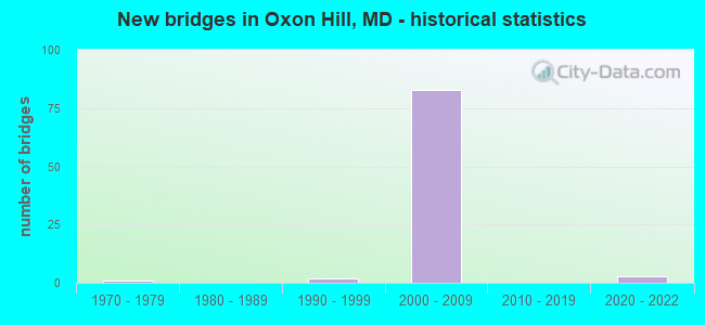
- New bridges - historical statistics
- 11970-1979
- 21990-1999
- 832000-2009
- 32020-2022


- Bridge Condition - Deck
- 18.8%Very good
- 68.8%Good
- 12.5%Satisfactory

- Bridge Condition - Superstructure
- 9.4%Excellent
- 21.9%Very good
- 62.5%Good
- 6.3%Satisfactory

- Bridge Condition - Substructure
- 9.4%Excellent
- 87.5%Good
- 3.1%Satisfactory

- Bridge Condition - Channel
- 25.0%Excellent
- 50.0%Very good
- 25.0%Good
Find on map >> Show street view
Structure Number: 16309, Location: 1.5 MILE SOUTH OF I-495 (Lat: 0.000106, Lng: -0.000019), Route carried "on" structure: County highway , Year Built: 2021, Status: Open, Structure Length: 2.28m (7.48ft), Average Daily Traffic: 6,525 (year 2014), Truck Traffic: 7%, Average Future Daily Traffic: 7,250 (year 2035), Features Intersected: Carey Branch, Facility Carried by Structure: Kerby Hill Road
Minimum Vertical Clearance: 30+ m (98+ ft), Kilometerpoint: 0.000, Lanes on structure: 2, Owner: State Highway Agency, Approaching Roadway Width: 12.8m (42.0ft), Skew: 2 degrees, Material/Design: Steel, Design/Construction: Girder and Floorbeam System, Number Of Spans In Main Unit: 1, Length of Maximum Span: 21.3m (69.9ft), Curb or Sidewalk Widths: Left: 1.7m (5.6ft), Right: 1.7m (5.6ft), Curb-To-Curb Width: 13.1m (43.0ft), Out-to-Out Width: 17.6m (57.7ft)
Condition: Deck: Very good, Superstructure: Excellent, Substructure: Excellent, Channel: Excellent, Operating Rating: 83.3 metric tons, Method Used To Determine Operating Rating: Load and Resistance Factor Rating (LRFR) rating reported by rating factor(RF) method using HL-93 loadings, Inventory Rating: 64.2 metric tons, Method Used To Determine Inventory Rating: Load and Resistance Factor Rating (LRFR) rating reported by rating factor(RF) method using HL-93 loadings, Structural Evaluation: Superior to present desirable criteria, Deck Geometry: Somewhat better than minimum adequacy, Approach Roadway Alignment: Equal to present desirable criteria, Designated Inspection Frequency: Every 24 months, Inspection Date: Febuary 2022, Deck Structure Type: Concrete Cast-file-Place, Wearing Surface/Protective System: Wearing Surface: Monolithic Concrete, Deck Protection: Epoxy Coated Reinforcing
Find on map >> Show street view
Structure Number: 100000160168015, Location: 0.48 MILE NORTH OF MD 210 (Lat: 38.806064, Lng: -76.990603), Route carried "on" structure: Interstate 95, Year Built: 2007, Status: Open, Structure Length: 2.90m (9.51ft), Average Daily Traffic: 57,732 (year 2021), Truck Traffic: 10%, Average Future Daily Traffic: 633,153 (year 2042), Design Load: HS 25 or greater, Features Intersected: LIVINGSTON ROAD
Minimum Vertical Clearance: 30+ m (98+ ft), Kilometerpoint: 5.215, Lanes on structure: 6, Lanes under structure: 4, Base Highway Network: Yes, Owner: State Highway Agency, Approaching Roadway Width: 43.3m (142.1ft), Skew: 30 degrees, Material/Design: Prestressed concrete continuous, Design/Construction: Stringer/Multi-beam, Number Of Spans In Main Unit: 1, Length of Maximum Span: 27.4m (89.9ft), Curb-To-Curb Width: 35.7m (117.1ft), Out-to-Out Width: 38.1m (125.0ft)
Condition: Deck: Good, Superstructure: Good, Substructure: Good, Operating Rating: 52.6 metric tons, Method Used To Determine Operating Rating: Load Factor (LF), Inventory Rating: 31.3 metric tons, Method Used To Determine Inventory Rating: Load Factor (LF), Structural Evaluation: Better than present minimum criteria, Deck Geometry: Superior to present desirable criteria, Underclear: Meets minimum limits, Approach Roadway Alignment: Equal to present desirable criteria, Designated Inspection Frequency: Every 24 months, Inspection Date: June 2021, Deck Structure Type: Concrete Cast-file-Place, Wearing Surface/Protective System: Wearing Surface: Monolithic Concrete, Deck Protection: Epoxy Coated Reinforcing
Find on map >> Show street view
Structure Number: 100000160168016, Location: 0.48 MILE NORTH OF MD 210 (Lat: 38.806314, Lng: -76.990289), Route carried "on" structure: Interstate 95, Year Built: 2008, Status: Open, Structure Length: 2.90m (9.51ft), Average Daily Traffic: 57,732 (year 2021), Truck Traffic: 10%, Average Future Daily Traffic: 633,153 (year 2042), Design Load: HS 25 or greater, Features Intersected: LIVINGSTON ROAD
Minimum Vertical Clearance: 30+ m (98+ ft), Kilometerpoint: 5.215, Lanes on structure: 6, Lanes under structure: 4, Base Highway Network: Yes, Owner: State Highway Agency, Approaching Roadway Width: 33.5m (109.9ft), Material/Design: Prestressed concrete continuous, Design/Construction: Stringer/Multi-beam, Number Of Spans In Main Unit: 1, Length of Maximum Span: 27.4m (89.9ft), Curb-To-Curb Width: 28.0m (91.9ft), Out-to-Out Width: 29.0m (95.1ft)
Condition: Deck: Good, Superstructure: Good, Substructure: Good, Operating Rating: 77.1 metric tons, Method Used To Determine Operating Rating: Load Factor (LF), Inventory Rating: 46.3 metric tons, Method Used To Determine Inventory Rating: Load Factor (LF), Structural Evaluation: Better than present minimum criteria, Deck Geometry: Equal to present minimum criteria, Underclear: Meets minimum limits, Approach Roadway Alignment: Equal to present desirable criteria, Designated Inspection Frequency: Every 24 months, Inspection Date: June 2021, Deck Structure Type: Concrete Cast-file-Place, Wearing Surface/Protective System: Wearing Surface: Monolithic Concrete, Deck Protection: Epoxy Coated Reinforcing
Find on map >> Show street view
Structure Number: 10000016016901, Location: 0.13 MILE NORTH OF MD 414 (Lat: 38.802739, Lng: -76.998828), Route carried "on" structure: State highway 210, Year Built: 2007, Status: Open, Structure Length: 13.23m (43.41ft), Average Daily Traffic: 28,550 (year 2018), Truck Traffic: 4%, Average Future Daily Traffic: 28,721 (year 2038), Design Load: HS 25 or greater, Features Intersected: IS 95/IS 495
Minimum Vertical Clearance: 30+ m (98+ ft), Kilometerpoint: 21.158, Lanes on structure: 7, Lanes under structure: 13, Owner: State Highway Agency, Approaching Roadway Width: 36.9m (121.1ft), Skew: 23 degrees, Material/Design: Steel continuous, Design/Construction: Stringer/Multi-beam, Number Of Spans In Main Unit: 2, Length of Maximum Span: 65.2m (213.9ft), Curb or Sidewalk Widths: Left: 1.6m (5.2ft), Right: 1.6m (5.2ft), Curb-To-Curb Width: 30.2m (99.1ft), Out-to-Out Width: 39.6m (129.9ft)
Condition: Deck: Satisfactory, Superstructure: Satisfactory, Substructure: Satisfactory, Inventory Rating: 63.5 metric tons, Method Used To Determine Inventory Rating: Load Factor (LF), Structural Evaluation: Equal to present minimum criteria, Deck Geometry: Somewhat better than minimum adequacy, Underclear: High priority of corrective action, Approach Roadway Alignment: Equal to present desirable criteria, Designated Inspection Frequency: Every 24 months, Inspection Date: September 2020, Deck Structure Type: Concrete Cast-file-Place, Wearing Surface/Protective System: Wearing Surface: Monolithic Concrete, Deck Protection: Epoxy Coated Reinforcing
Find on map >> Show street view
Structure Number: 10000016017001, Location: 0.027 MI N OF MD 414 (Lat: 38.801547, Lng: -77.001186), Route carried "on" structure: Federal lands road 210V, Year Built: 2005, Status: Open, Structure Length: 11.49m (37.70ft), Average Daily Traffic: 552 (year 2020), Truck Traffic: 5%, Average Future Daily Traffic: 24,205 (year 2042), Design Load: HS 25 or greater, Features Intersected: IS 95/IS 495, Facility Carried by Structure: MD 210 BALD EAGLE
Minimum Vertical Clearance: 30+ m (98+ ft), Kilometerpoint: 0.043, Lanes on structure: 2, Lanes under structure: 13, Owner: State Highway Agency, Approaching Roadway Width: 9.1m (29.9ft), Skew: 1 degrees, Material/Design: Steel continuous, Design/Construction: Stringer/Multi-beam, Number Of Spans In Main Unit: 2, Length of Maximum Span: 57.9m (190.0ft), Curb or Sidewalk Widths: Left: 0.0m, Right: 1.6m (5.2ft), Curb-To-Curb Width: 9.1m (29.9ft), Out-to-Out Width: 11.8m (38.7ft)
Condition: Deck: Good, Superstructure: Good, Substructure: Good, Inventory Rating: 59.9 metric tons, Method Used To Determine Inventory Rating: Load Factor (LF), Structural Evaluation: Better than present minimum criteria, Deck Geometry: Equal to present minimum criteria, Underclear: High priority of corrective action, Approach Roadway Alignment: Equal to present desirable criteria, Designated Inspection Frequency: Every 24 months, Inspection Date: September 2020, Deck Structure Type: Concrete Cast-file-Place, Wearing Surface/Protective System: Wearing Surface: Monolithic Concrete, Deck Protection: Epoxy Coated Reinforcing
Find on map >> Show street view
Structure Number: 100000160173015, Location: ON VIRGINIA LINE (Lat: 38.793075, Lng: -77.046311), Route carried "on" structure: Interstate 95, Year Built: 2008, Status: Open, Structure Length: 185.53m (608.69ft), Average Daily Traffic: 87,402 (year 2006), Truck Traffic: 10%, Average Future Daily Traffic: 94,394 (year 2026), Design Load: HS 25 or greater, Features Intersected: POTOMAC RIVER
Minimum Vertical Clearance: 5.18m (16.99ft), Kilometerpoint: 0.274, Lanes on structure: 5, Base Highway Network: Yes, Owner: State Highway Agency, Approaching Roadway Width: 31.7m (104.0ft), Skew: 30 degrees, Navigation Control: Yes ( Vertical Clearance: 21.3m (69.9ft), Horizontal Clearance: 53.3m (174.9ft)), Material/Design: Steel, Design/Construction: Movable - Bascule, Number Of Spans In Main Unit: 3, Number Of Approach Spans: 32, Length of Maximum Span: 82.3m (270.0ft), Curb-To-Curb Width: 31.7m (104.0ft), Out-to-Out Width: 37.7m (123.7ft)
Condition: Deck: Satisfactory, Superstructure: Good, Substructure: Good, Channel: Very good, Operating Rating: 63.0 metric tons, Method Used To Determine Operating Rating: Load Factor (LF), Inventory Rating: 37.6 metric tons, Method Used To Determine Inventory Rating: Load Factor (LF), Structural Evaluation: Better than present minimum criteria, Deck Geometry: Equal to present desirable criteria, Waterway Adequacy: Superior to present desirable criteria, Approach Roadway Alignment: Equal to present desirable criteria, Designated Inspection Frequency: Every 24 months, Critical Feature Inspection Frequency: Every 24 months, Underwater Inspection Frequency: Every 48 months, Other Special Inspection Frequency: Every 24 months, Inspection Date: June 2020, Critical Feature Inspection Date: June 2020, Underwater Inspection Date: June 2018, Other Special Inspection Date: June 2020, Deck Structure Type: Concrete Cast-file-Place, Wearing Surface/Protective System: Deck Protection: Epoxy Coated Reinforcing
Find on map >> Show street view
Structure Number: 100000160173016, Location: ON VIRGINIA LINE (Lat: 38.793219, Lng: -77.025056), Route carried "on" structure: Interstate 95, Year Built: 2006, Status: Open, Structure Length: 185.53m (608.69ft), Average Daily Traffic: 87,402 (year 2006), Truck Traffic: 11%, Average Future Daily Traffic: 94,394 (year 2026), Design Load: HS 25 or greater, Features Intersected: POTOMAC RIVER
Minimum Vertical Clearance: 5.18m (16.99ft), Kilometerpoint: 0.274, Lanes on structure: 5, Base Highway Network: Yes, Owner: State Highway Agency, Approaching Roadway Width: 31.7m (104.0ft), Skew: 30 degrees, Navigation Control: Yes ( Vertical Clearance: 21.3m (69.9ft), Horizontal Clearance: 53.3m (174.9ft)), Material/Design: Steel, Design/Construction: Movable - Bascule, Number Of Spans In Main Unit: 3, Number Of Approach Spans: 32, Length of Maximum Span: 82.3m (270.0ft), Curb-To-Curb Width: 31.7m (104.0ft), Out-to-Out Width: 33.5m (109.9ft)
Condition: Deck: Satisfactory, Superstructure: Good, Substructure: Good, Channel: Very good, Operating Rating: 64.9 metric tons, Method Used To Determine Operating Rating: Load Factor (LF), Inventory Rating: 38.5 metric tons, Method Used To Determine Inventory Rating: Load Factor (LF), Structural Evaluation: Better than present minimum criteria, Deck Geometry: Equal to present desirable criteria, Waterway Adequacy: Superior to present desirable criteria, Approach Roadway Alignment: Equal to present desirable criteria, Designated Inspection Frequency: Every 24 months, Critical Feature Inspection Frequency: Every 24 months, Underwater Inspection Frequency: Every 48 months, Other Special Inspection Frequency: Every 24 months, Inspection Date: June 2020, Critical Feature Inspection Date: June 2020, Underwater Inspection Date: June 2018, Other Special Inspection Date: June 2020, Deck Structure Type: Concrete Cast-file-Place, Wearing Surface/Protective System: Deck Protection: Epoxy Coated Reinforcing
Find on map >> Show street view
Structure Number: 10000016021801, Location: 0.8 M S OF WASH DCLINE (Lat: 0.000108, Lng: -0.000214), Route carried "on" structure: Ramp Interstate 295, Year Built: 2003, Status: Open, Structure Length: 43.68m (143.31ft), Average Daily Traffic: 26,853 (year 2021), Truck Traffic: 8%, Average Future Daily Traffic: 31,416 (year 2042), Design Load: HS 25 or greater, Features Intersected: IS 95/495, RMPS B,T,Q,H
Minimum Vertical Clearance: 30+ m (98+ ft), Kilometerpoint: 0.000, Lanes on structure: 2, Lanes under structure: 17, Base Highway Network: Yes, Owner: State Highway Agency, Approaching Roadway Width: 12.2m (40.0ft), Material/Design: Steel continuous, Design/Construction: Stringer/Multi-beam, Number Of Spans In Main Unit: 10, Length of Maximum Span: 55.2m (181.1ft), Curb-To-Curb Width: 12.2m (40.0ft), Out-to-Out Width: 13.4m (44.0ft)
Condition: Deck: Good, Superstructure: Very good, Substructure: Good, Operating Rating: 75.7 metric tons, Method Used To Determine Operating Rating: Load Factor (LF), Inventory Rating: 45.4 metric tons, Method Used To Determine Inventory Rating: Load Factor (LF), Structural Evaluation: Better than present minimum criteria, Deck Geometry: Superior to present desirable criteria, Underclear: Meets minimum limits, Approach Roadway Alignment: Equal to present desirable criteria, Designated Inspection Frequency: Every 24 months, Critical Feature Inspection Frequency: Every 24 months, Inspection Date: August 2021, Critical Feature Inspection Date: August 2021, Deck Structure Type: Concrete Cast-file-Place, Wearing Surface/Protective System: Wearing Surface: Monolithic Concrete, Deck Protection: Epoxy Coated Reinforcing
Find on map >> Show street view
Structure Number: 100000160219011, Location: 0.18 M N OF BR NO 1622100 (Lat: 38.800636, Lng: -77.001400), Route carried "on" structure: Interstate 295, Year Built: 1990, Status: Open, Structure Length: 4.54m (14.90ft), Average Daily Traffic: 14,985 (year 2020), Truck Traffic: 8%, Average Future Daily Traffic: 17,509 (year 2042), Design Load: HS 20+Mod, Features Intersected: MD 414 (OXON HILL ROAD), Facility Carried by Structure: IS 95 RAMP F(1)
Minimum Vertical Clearance: 30+ m (98+ ft), Kilometerpoint: 0.869, Lanes on structure: 2, Lanes under structure: 5, Base Highway Network: Yes, Owner: State Highway Agency, Approaching Roadway Width: 12.2m (40.0ft), Skew: 4 degrees, Material/Design: Steel, Design/Construction: Stringer/Multi-beam, Number Of Spans In Main Unit: 1, Length of Maximum Span: 43.3m (142.1ft), Curb-To-Curb Width: 12.2m (40.0ft), Out-to-Out Width: 13.2m (43.3ft)
Condition: Deck: Good, Superstructure: Satisfactory, Substructure: Good, Inventory Rating: 62.1 metric tons, Method Used To Determine Inventory Rating: Load Factor (LF), Structural Evaluation: Equal to present minimum criteria, Deck Geometry: Better than present minimum criteria, Underclear: Equal to present minimum criteria, Approach Roadway Alignment: Equal to present desirable criteria, Designated Inspection Frequency: Every 24 months, Inspection Date: September 2020, Deck Structure Type: Concrete Cast-file-Place, Wearing Surface/Protective System: Wearing Surface: Monolithic Concrete, Deck Protection: Epoxy Coated Reinforcing
Find on map >> Show street view
Structure Number: 10000016022001, Location: 0.1 MI W OF MD 210 (Lat: 38.802044, Lng: -76.996744), Route carried "on" structure: Ramp State highway 210, Year Built: 2005, Status: Open, Structure Length: 5.15m (16.90ft), Average Daily Traffic: 10,040 (year 2006), Truck Traffic: 10%, Average Future Daily Traffic: 11,576 (year 2026), Design Load: HS 25 or greater, Features Intersected: MD 414 (OXON HILL ROAD)
Minimum Vertical Clearance: 30+ m (98+ ft), Kilometerpoint: 20.949, Lanes on structure: 1, Lanes under structure: 7, Base Highway Network: Yes, Owner: State Highway Agency, Approaching Roadway Width: 8.2m (26.9ft), Skew: 2 degrees, Material/Design: Steel, Design/Construction: Stringer/Multi-beam, Number Of Spans In Main Unit: 1, Length of Maximum Span: 49.7m (163.1ft), Curb-To-Curb Width: 8.2m (26.9ft), Out-to-Out Width: 9.1m (29.9ft)
Condition: Deck: Good, Superstructure: Good, Substructure: Good, Operating Rating: 90.2 metric tons, Method Used To Determine Operating Rating: Load Factor (LF), Inventory Rating: 54.0 metric tons, Method Used To Determine Inventory Rating: Load Factor (LF), Structural Evaluation: Better than present minimum criteria, Deck Geometry: Superior to present desirable criteria, Underclear: Somewhat better than minimum adequacy, Approach Roadway Alignment: Equal to present minimum criteria, Designated Inspection Frequency: Every 24 months, Inspection Date: April 2021, Deck Structure Type: Concrete Cast-file-Place, Wearing Surface/Protective System: Wearing Surface: Monolithic Concrete, Deck Protection: Epoxy Coated Reinforcing
Find on map >> Show street view
Structure Number: 10000016026601, Location: 2.0 M W OF MD210 OXENHILL (Lat: 38.795542, Lng: -77.014017), Route carried "on" structure: Ramp Interstate 95, Year Built: 2004, Status: Open, Structure Length: 4.91m (16.11ft), Average Daily Traffic: 141,180 (year 2009), Truck Traffic: 10%, Average Future Daily Traffic: 151,460 (year 2029), Design Load: HS 25 or greater, Features Intersected: IS 95/IS 495 RAMPS B & T
Minimum Vertical Clearance: 8.53m (27.99ft), Kilometerpoint: 2.898, Lanes on structure: 2, Lanes under structure: 3, Base Highway Network: Yes, Owner: State Highway Agency, Approaching Roadway Width: 13.4m (44.0ft), Skew: 1 degrees, Material/Design: Prestressed concrete continuous, Design/Construction: Stringer/Multi-beam, Number Of Spans In Main Unit: 2, Length of Maximum Span: 25.9m (85.0ft), Curb-To-Curb Width: 13.6m (44.6ft), Out-to-Out Width: 14.8m (48.6ft)
Condition: Deck: Good, Superstructure: Good, Substructure: Good, Operating Rating: 59.4 metric tons, Method Used To Determine Operating Rating: Load Factor (LF), Inventory Rating: 18.1 metric tons, Method Used To Determine Inventory Rating: Load Factor (LF), Structural Evaluation: Meets minimum limits, Deck Geometry: Superior to present desirable criteria, Underclear: Meets minimum limits, Approach Roadway Alignment: Equal to present desirable criteria, Designated Inspection Frequency: Every 24 months, Inspection Date: August 2021, Deck Structure Type: Concrete Cast-file-Place, Wearing Surface/Protective System: Wearing Surface: Monolithic Concrete, Deck Protection: Epoxy Coated Reinforcing
Find on map >> Show street view
Structure Number: 10000016026701, Location: 0.8 M S OF WASH DCLINE (Lat: 38.795681, Lng: -77.015533), Route carried "on" structure: Ramp Interstate 295, Year Built: 2003, Status: Open, Structure Length: 44.29m (145.31ft), Average Daily Traffic: 78,272 (year 2020), Truck Traffic: 8%, Average Future Daily Traffic: 84,271 (year 2040), Design Load: HS 25 or greater, Features Intersected: IS 95/495, RPS B.T,Q,R,H
Minimum Vertical Clearance: 30+ m (98+ ft), Kilometerpoint: 0.000, Lanes on structure: 2, Lanes under structure: 17, Base Highway Network: Yes, Owner: State Highway Agency, Approaching Roadway Width: 12.2m (40.0ft), Material/Design: Steel continuous, Design/Construction: Stringer/Multi-beam, Number Of Spans In Main Unit: 9, Length of Maximum Span: 61.3m (201.1ft), Curb-To-Curb Width: 12.2m (40.0ft), Out-to-Out Width: 13.4m (44.0ft)
Condition: Deck: Good, Superstructure: Good, Substructure: Good, Operating Rating: 83.0 metric tons, Method Used To Determine Operating Rating: Load Factor (LF), Inventory Rating: 49.4 metric tons, Method Used To Determine Inventory Rating: Load Factor (LF), Structural Evaluation: Better than present minimum criteria, Deck Geometry: Superior to present desirable criteria, Underclear: High priority of corrective action, Approach Roadway Alignment: Equal to present desirable criteria, Designated Inspection Frequency: Every 24 months, Critical Feature Inspection Frequency: Every 24 months, Inspection Date: August 2021, Critical Feature Inspection Date: August 2021, Deck Structure Type: Concrete Cast-file-Place, Wearing Surface/Protective System: Wearing Surface: Monolithic Concrete, Deck Protection: Epoxy Coated Reinforcing
Find on map >> Show street view
Structure Number: 10000016026801, Location: I-295 S Ramp to I-95/495 (Lat: 38.795158, Lng: -77.012819), Route carried "on" structure: Ramp Interstate 95, Year Built: 2003, Status: Open, Structure Length: 9.33m (30.61ft), Average Daily Traffic: 97,959 (year 2021), Average Future Daily Traffic: 148,473 (year 2042), Design Load: HS 25 or greater, Features Intersected: RAMP 'Q'
Minimum Vertical Clearance: 30+ m (98+ ft), Kilometerpoint: 0.092, Lanes on structure: 1, Lanes under structure: 1, Base Highway Network: Yes, Owner: State Highway Agency, Approaching Roadway Width: 9.4m (30.8ft), Material/Design: Steel continuous, Design/Construction: Stringer/Multi-beam, Number Of Spans In Main Unit: 2, Length of Maximum Span: 46.0m (150.9ft), Curb-To-Curb Width: 9.4m (30.8ft), Out-to-Out Width: 10.7m (35.1ft)
Condition: Deck: Good, Superstructure: Good, Substructure: Good, Inventory Rating: 52.2 metric tons, Method Used To Determine Inventory Rating: Load Factor (LF), Structural Evaluation: Better than present minimum criteria, Deck Geometry: Superior to present desirable criteria, Underclear: High priority of corrective action, Approach Roadway Alignment: Equal to present desirable criteria, Designated Inspection Frequency: Every 24 months, Inspection Date: July 2021, Deck Structure Type: Concrete Cast-file-Place, Wearing Surface/Protective System: Wearing Surface: Monolithic Concrete, Deck Protection: Epoxy Coated Reinforcing
Find on map >> Show street view
Structure Number: 10000016027001, Location: 2.0 MILES WEST OF MD 210 (Lat: 38.796119, Lng: -77.012553), Route carried "on" structure: Interstate 95, Year Built: 2005, Status: Open, Structure Length: 3.75m (12.30ft), Average Daily Traffic: 146,744 (year 2020), Truck Traffic: 8%, Average Future Daily Traffic: 158,538 (year 2042), Design Load: HS 25 or greater, Features Intersected: RAMP Q(1)
Minimum Vertical Clearance: 30+ m (98+ ft), Kilometerpoint: 3.020, Lanes on structure: 2, Lanes under structure: 1, Base Highway Network: Yes, Owner: State Highway Agency, Approaching Roadway Width: 13.4m (44.0ft), Skew: 2 degrees, Material/Design: Prestressed concrete continuous, Design/Construction: Stringer/Multi-beam, Number Of Spans In Main Unit: 1, Length of Maximum Span: 36.0m (118.1ft), Curb-To-Curb Width: 13.6m (44.6ft), Out-to-Out Width: 14.8m (48.6ft)
Condition: Deck: Good, Superstructure: Good, Substructure: Good, Inventory Rating: 55.8 metric tons, Method Used To Determine Inventory Rating: Allowable Stress (AS), Structural Evaluation: Better than present minimum criteria, Deck Geometry: Superior to present desirable criteria, Underclear: Equal to present desirable criteria, Approach Roadway Alignment: Equal to present desirable criteria, Designated Inspection Frequency: Every 24 months, Inspection Date: November 2020, Deck Structure Type: Concrete Cast-file-Place, Wearing Surface/Protective System: Wearing Surface: Monolithic Concrete, Deck Protection: Epoxy Coated Reinforcing
Find on map >> Show street view
Structure Number: 10000016027101, Location: 2.0 MILE WEST OF MD 210 (Lat: 38.794381, Lng: -77.014017), Route carried "on" structure: Interstate 95, Year Built: 2004, Status: Open, Structure Length: 18.35m (60.20ft), Average Daily Traffic: 191,981 (year 2010), Truck Traffic: 8%, Average Future Daily Traffic: 233,661 (year 2030), Design Load: HS 25 or greater, Features Intersected: RAMPS B, T, Q AND H
Minimum Vertical Clearance: 30+ m (98+ ft), Kilometerpoint: 0.451, Lanes on structure: 1, Lanes under structure: 6, Owner: State Highway Agency, Approaching Roadway Width: 9.1m (29.9ft), Material/Design: Steel continuous, Design/Construction: Stringer/Multi-beam, Number Of Spans In Main Unit: 3, Length of Maximum Span: 62.5m (205.1ft), Curb-To-Curb Width: 9.1m (29.9ft), Out-to-Out Width: 10.4m (34.1ft)
Condition: Deck: Good, Superstructure: Very good, Substructure: Good, Operating Rating: 78.9 metric tons, Method Used To Determine Operating Rating: Load Factor (LF), Inventory Rating: 47.2 metric tons, Method Used To Determine Inventory Rating: Load Factor (LF), Structural Evaluation: Better than present minimum criteria, Deck Geometry: Meets minimum limits, Underclear: Meets minimum limits, Approach Roadway Alignment: Equal to present desirable criteria, Designated Inspection Frequency: Every 24 months, Inspection Date: August 2021, Deck Structure Type: Concrete Cast-file-Place, Wearing Surface/Protective System: Wearing Surface: Monolithic Concrete, Deck Protection: Epoxy Coated Reinforcing
Find on map >> Show street view
Structure Number: 10000016027201, Location: 2.0 MILES WEST OF MD 210 (Lat: 0.000108, Lng: -0.000214), Route carried "on" structure: Ramp Interstate 95, Year Built: 2005, Status: Open, Structure Length: 60.56m (198.69ft), Average Daily Traffic: 7,492 (year 2019), Average Future Daily Traffic: 14,290 (year 2041), Design Load: HS 25 or greater, Features Intersected: IS 95 OLL, RPS G,B,T,Q,H
Minimum Vertical Clearance: 30+ m (98+ ft), Kilometerpoint: 0.764, Lanes on structure: 1, Lanes under structure: 9, Base Highway Network: Yes, Owner: State Highway Agency, Approaching Roadway Width: 9.8m (32.2ft), Material/Design: Steel continuous, Design/Construction: Stringer/Multi-beam, Number Of Spans In Main Unit: 11, Length of Maximum Span: 73.2m (240.2ft), Curb-To-Curb Width: 9.8m (32.2ft), Out-to-Out Width: 11.0m (36.1ft)
Condition: Deck: Good, Superstructure: Very good, Substructure: Good, Operating Rating: 76.2 metric tons, Method Used To Determine Operating Rating: Load Factor (LF), Inventory Rating: 45.4 metric tons, Method Used To Determine Inventory Rating: Load Factor (LF), Structural Evaluation: Better than present minimum criteria, Deck Geometry: Superior to present desirable criteria, Underclear: Superior to present desirable criteria, Approach Roadway Alignment: Equal to present desirable criteria, Designated Inspection Frequency: Every 24 months, Inspection Date: September 2021, Deck Structure Type: Concrete Cast-file-Place, Wearing Surface/Protective System: Wearing Surface: Monolithic Concrete, Deck Protection: Epoxy Coated Reinforcing
Find on map >> Show street view
Structure Number: 10000016027301, Location: 2.0 MILES WEST OF MD 210 (Lat: 38.793039, Lng: -77.015847), Route carried "on" structure: Ramp Interstate 95, Year Built: 2005, Status: Open, Structure Length: 3.72m (12.20ft), Average Daily Traffic: 191,981 (year 2010), Average Future Daily Traffic: 233,661 (year 2030), Design Load: HS 25 or greater, Features Intersected: IS 95/IS 495 RAMP 'B'
Minimum Vertical Clearance: 30+ m (98+ ft), Kilometerpoint: 0.111, Lanes on structure: 1, Lanes under structure: 2, Owner: State Highway Agency, Approaching Roadway Width: 9.1m (29.9ft), Skew: 2 degrees, Material/Design: Prestressed concrete, Design/Construction: Stringer/Multi-beam, Number Of Spans In Main Unit: 1, Length of Maximum Span: 35.7m (117.1ft), Curb-To-Curb Width: 9.1m (29.9ft), Out-to-Out Width: 10.4m (34.1ft)
Condition: Deck: Very good, Superstructure: Good, Substructure: Good, Operating Rating: 73.0 metric tons, Method Used To Determine Operating Rating: Load Factor (LF), Inventory Rating: 44.0 metric tons, Method Used To Determine Inventory Rating: Load Factor (LF), Structural Evaluation: Better than present minimum criteria, Deck Geometry: Superior to present desirable criteria, Underclear: Equal to present desirable criteria, Approach Roadway Alignment: Equal to present desirable criteria, Designated Inspection Frequency: Every 24 months, Inspection Date: August 2021, Deck Structure Type: Concrete Cast-file-Place, Wearing Surface/Protective System: Wearing Surface: Monolithic Concrete, Deck Protection: Epoxy Coated Reinforcing
Find on map >> Show street view
Structure Number: 10000016027401, Location: 2.0 MILE WEST OF MD 210 (Lat: 38.793142, Lng: -77.015258), Route carried "on" structure: Ramp Interstate 95, Year Built: 2005, Status: Open, Structure Length: 3.78m (12.40ft), Average Daily Traffic: 191,981 (year 2010), Average Future Daily Traffic: 233,661 (year 2030), Design Load: HS 25 or greater, Features Intersected: IS 95/IS 495 RAMP 'B'
Minimum Vertical Clearance: 30+ m (98+ ft), Kilometerpoint: 0.608, Lanes on structure: 1, Lanes under structure: 2, Owner: State Highway Agency, Approaching Roadway Width: 11.6m (38.1ft), Material/Design: Prestressed concrete, Design/Construction: Stringer/Multi-beam, Number Of Spans In Main Unit: 1, Length of Maximum Span: 36.3m (119.1ft), Curb-To-Curb Width: 11.6m (38.1ft), Out-to-Out Width: 12.8m (42.0ft)
Condition: Deck: Very good, Superstructure: Good, Substructure: Good, Operating Rating: 70.7 metric tons, Method Used To Determine Operating Rating: Load Factor (LF), Inventory Rating: 42.6 metric tons, Method Used To Determine Inventory Rating: Load Factor (LF), Structural Evaluation: Better than present minimum criteria, Deck Geometry: Superior to present desirable criteria, Underclear: Superior to present desirable criteria, Approach Roadway Alignment: Equal to present desirable criteria, Designated Inspection Frequency: Every 24 months, Inspection Date: August 2021, Deck Structure Type: Concrete Cast-file-Place, Wearing Surface/Protective System: Wearing Surface: Monolithic Concrete, Deck Protection: Epoxy Coated Reinforcing
Find on map >> Show street view
Structure Number: 10000016027501, Location: 2.0 MILES WEST OF MD 210 (Lat: 38.792000, Lng: -77.014564), Route carried "on" structure: Ramp Interstate 95, Year Built: 2004, Status: Open, Structure Length: 6.40m (21.00ft), Average Daily Traffic: 191,981 (year 2010), Average Future Daily Traffic: 233,661 (year 2030), Design Load: HS 25 or greater, Features Intersected: IS 95/IS 495 RMPS K,P,X
Minimum Vertical Clearance: 30+ m (98+ ft), Kilometerpoint: 0.748, Lanes on structure: 2, Lanes under structure: 3, Base Highway Network: Yes, Owner: State Highway Agency, Approaching Roadway Width: 12.2m (40.0ft), Skew: 1 degrees, Material/Design: Steel continuous, Design/Construction: Stringer/Multi-beam, Number Of Spans In Main Unit: 2, Length of Maximum Span: 36.6m (120.1ft), Curb-To-Curb Width: 12.2m (40.0ft), Out-to-Out Width: 13.4m (44.0ft)
Condition: Deck: Good, Superstructure: Very good, Substructure: Good, Operating Rating: 80.3 metric tons, Method Used To Determine Operating Rating: Load Factor (LF), Inventory Rating: 48.1 metric tons, Method Used To Determine Inventory Rating: Load Factor (LF), Structural Evaluation: Better than present minimum criteria, Deck Geometry: Superior to present desirable criteria, Underclear: High priority of corrective action, Approach Roadway Alignment: Equal to present desirable criteria, Designated Inspection Frequency: Every 24 months, Inspection Date: June 2021, Deck Structure Type: Concrete Cast-file-Place, Wearing Surface/Protective System: Wearing Surface: Monolithic Concrete, Deck Protection: Epoxy Coated Reinforcing
Find on map >> Show street view
Structure Number: 10000016027601, Location: 2.0 MILES WEST OF MD 210 (Lat: 38.791714, Lng: -77.013844), Route carried "on" structure: Ramp Interstate 95, Year Built: 2004, Status: Open, Structure Length: 5.82m (19.09ft), Average Daily Traffic: 191,981 (year 2010), Average Future Daily Traffic: 233,661 (year 2030), Design Load: HS 25 or greater, Features Intersected: IS 95/IS 495 RMPS K,P,X
Minimum Vertical Clearance: 30+ m (98+ ft), Kilometerpoint: 0.188, Lanes on structure: 1, Lanes under structure: 3, Owner: State Highway Agency, Approaching Roadway Width: 6.1m (20.0ft), Material/Design: Steel continuous, Design/Construction: Stringer/Multi-beam, Number Of Spans In Main Unit: 2, Length of Maximum Span: 30.5m (100.1ft), Curb-To-Curb Width: 6.1m (20.0ft), Out-to-Out Width: 7.3m (24.0ft)
Condition: Deck: Good, Superstructure: Very good, Substructure: Good, Operating Rating: 83.0 metric tons, Method Used To Determine Operating Rating: Load Factor (LF), Inventory Rating: 49.4 metric tons, Method Used To Determine Inventory Rating: Load Factor (LF), Structural Evaluation: Better than present minimum criteria, Deck Geometry: Somewhat better than minimum adequacy, Underclear: High priority of corrective action, Approach Roadway Alignment: Equal to present desirable criteria, Designated Inspection Frequency: Every 24 months, Critical Feature Inspection Frequency: Every 24 months, Inspection Date: June 2021, Critical Feature Inspection Date: June 2021, Deck Structure Type: Concrete Cast-file-Place, Wearing Surface/Protective System: Wearing Surface: Monolithic Concrete, Deck Protection: Epoxy Coated Reinforcing
Find on map >> Show street view
Structure Number: 10000016027701, Location: 2.0 MILES WEST OF MD 210 (Lat: 38.791858, Lng: -77.013469), Route carried "on" structure: Ramp Interstate 95, Year Built: 2004, Status: Open, Structure Length: 6.19m (20.31ft), Average Daily Traffic: 191,981 (year 2010), Average Future Daily Traffic: 233,661 (year 2030), Design Load: HS 25 or greater, Features Intersected: BELTWAY ACCESS PARCEL RD
Minimum Vertical Clearance: 30+ m (98+ ft), Kilometerpoint: 0.666, Lanes on structure: 1, Lanes under structure: 2, Owner: State Highway Agency, Approaching Roadway Width: 6.1m (20.0ft), Skew: 2 degrees, Material/Design: Steel continuous, Design/Construction: Stringer/Multi-beam, Number Of Spans In Main Unit: 2, Length of Maximum Span: 33.5m (109.9ft), Curb-To-Curb Width: 6.1m (20.0ft), Out-to-Out Width: 7.3m (24.0ft)
Condition: Deck: Good, Superstructure: Very good, Substructure: Good, Operating Rating: 89.3 metric tons, Method Used To Determine Operating Rating: Load Factor (LF), Inventory Rating: 53.5 metric tons, Method Used To Determine Inventory Rating: Load Factor (LF), Structural Evaluation: Better than present minimum criteria, Deck Geometry: Somewhat better than minimum adequacy, Underclear: High priority of corrective action, Approach Roadway Alignment: Equal to present desirable criteria, Designated Inspection Frequency: Every 24 months, Critical Feature Inspection Frequency: Every 24 months, Inspection Date: June 2021, Critical Feature Inspection Date: June 2021, Deck Structure Type: Concrete Cast-file-Place, Wearing Surface/Protective System: Wearing Surface: Monolithic Concrete, Deck Protection: Epoxy Coated Reinforcing
Find on map >> Show street view
Structure Number: 10000016027801, Location: 2.0 MILES WEST OF MD 210 (Lat: 38.791911, Lng: -77.013375), Route carried "on" structure: Ramp Interstate 95, Year Built: 2004, Status: Open, Structure Length: 10.21m (33.50ft), Average Daily Traffic: 191,981 (year 2010), Average Future Daily Traffic: 233,661 (year 2030), Design Load: HS 25 or greater, Features Intersected: IS 95 RP V & BELTWAY PAR
Minimum Vertical Clearance: 30+ m (98+ ft), Kilometerpoint: 0.164, Lanes on structure: 1, Lanes under structure: 3, Owner: State Highway Agency, Approaching Roadway Width: 6.1m (20.0ft), Skew: 3 degrees, Material/Design: Steel continuous, Design/Construction: Stringer/Multi-beam, Number Of Spans In Main Unit: 3, Length of Maximum Span: 36.0m (118.1ft), Curb-To-Curb Width: 6.1m (20.0ft), Out-to-Out Width: 7.3m (24.0ft)
Condition: Deck: Good, Superstructure: Good, Substructure: Good, Operating Rating: 85.7 metric tons, Method Used To Determine Operating Rating: Load Factor (LF), Inventory Rating: 51.2 metric tons, Method Used To Determine Inventory Rating: Load Factor (LF), Structural Evaluation: Better than present minimum criteria, Deck Geometry: Somewhat better than minimum adequacy, Underclear: High priority of corrective action, Approach Roadway Alignment: Equal to present desirable criteria, Designated Inspection Frequency: Every 24 months, Critical Feature Inspection Frequency: Every 24 months, Inspection Date: June 2021, Critical Feature Inspection Date: June 2021, Deck Structure Type: Concrete Cast-file-Place, Wearing Surface/Protective System: Wearing Surface: Monolithic Concrete, Deck Protection: Epoxy Coated Reinforcing
Find on map >> Show street view
Structure Number: 10000016028001, Location: 2.0 MILES WEST OF MD 210 (Lat: 38.796047, Lng: -77.013794), Route carried "on" structure: ServiceInterstate 95, Year Built: 2006, Status: Open, Structure Length: 4.75m (15.58ft), Average Daily Traffic: 141,180 (year 2009), Average Future Daily Traffic: 151,460 (year 2029), Design Load: HS 25 or greater, Features Intersected: IS 95/IS 495 RAMPS B & T
Minimum Vertical Clearance: 30+ m (98+ ft), Kilometerpoint: 2.866, Lanes on structure: 2, Lanes under structure: 3, Base Highway Network: Yes, Owner: State Highway Agency, Approaching Roadway Width: 13.4m (44.0ft), Material/Design: Prestressed concrete continuous, Design/Construction: Stringer/Multi-beam, Number Of Spans In Main Unit: 2, Length of Maximum Span: 25.3m (83.0ft), Curb-To-Curb Width: 13.7m (44.9ft), Out-to-Out Width: 14.9m (48.9ft)
Condition: Deck: Good, Superstructure: Good, Substructure: Good, Operating Rating: 34.5 metric tons, Method Used To Determine Operating Rating: Load Factor (LF), Inventory Rating: 20.4 metric tons, Method Used To Determine Inventory Rating: Load Factor (LF), Structural Evaluation: Somewhat better than minimum adequacy, Deck Geometry: Superior to present desirable criteria, Underclear: Meets minimum limits, Approach Roadway Alignment: Equal to present desirable criteria, Designated Inspection Frequency: Every 24 months, Inspection Date: August 2021, Deck Structure Type: Concrete Cast-file-Place, Wearing Surface/Protective System: Wearing Surface: Monolithic Concrete, Deck Protection: Epoxy Coated Reinforcing
Find on map >> Show street view
Structure Number: 10000016028101, Location: 2.0 MILE WEST OF MD 210 (Lat: 38.796517, Lng: -77.012747), Route carried "on" structure: ServiceInterstate 95, Year Built: 2006, Status: Open, Structure Length: 3.51m (11.52ft), Average Daily Traffic: 141,180 (year 2009), Average Future Daily Traffic: 151,460 (year 2029), Design Load: HS 25 or greater, Features Intersected: IS 95/IS 495 RAMP 'Q'
Minimum Vertical Clearance: 30+ m (98+ ft), Kilometerpoint: 3.020, Lanes on structure: 2, Lanes under structure: 1, Base Highway Network: Yes, Owner: State Highway Agency, Approaching Roadway Width: 13.7m (44.9ft), Skew: 3 degrees, Material/Design: Prestressed concrete, Design/Construction: Stringer/Multi-beam, Number Of Spans In Main Unit: 1, Length of Maximum Span: 33.5m (109.9ft), Curb-To-Curb Width: 13.6m (44.6ft), Out-to-Out Width: 14.9m (48.9ft)
Condition: Deck: Good, Superstructure: Good, Substructure: Good, Operating Rating: 81.6 metric tons, Method Used To Determine Operating Rating: Load Factor (LF), Inventory Rating: 49.0 metric tons, Method Used To Determine Inventory Rating: Load Factor (LF), Structural Evaluation: Better than present minimum criteria, Deck Geometry: Superior to present desirable criteria, Underclear: Equal to present desirable criteria, Approach Roadway Alignment: Equal to present desirable criteria, Designated Inspection Frequency: Every 24 months, Inspection Date: August 2021, Deck Structure Type: Concrete Cast-file-Place, Wearing Surface/Protective System: Wearing Surface: Monolithic Concrete, Deck Protection: Epoxy Coated Reinforcing
Find on map >> Show street view
Structure Number: 10000016028201, Location: 0.89 MILE WEST OF MD 210 (Lat: 38.796456, Lng: -77.012372), Route carried "on" structure: Interstate 95, Year Built: 2008, Status: Open, Structure Length: 3.63m (11.91ft), Average Daily Traffic: 146,744 (year 2020), Truck Traffic: 8%, Average Future Daily Traffic: 158,538 (year 2042), Design Load: HS 25 or greater, Features Intersected: IS 95/IS 495 RAMP 'Q'
Minimum Vertical Clearance: 30+ m (98+ ft), Kilometerpoint: 3.025, Lanes on structure: 4, Lanes under structure: 1, Base Highway Network: Yes, Owner: State Highway Agency, Approaching Roadway Width: 38.4m (126.0ft), Skew: 31 degrees, Material/Design: Prestressed concrete, Design/Construction: Stringer/Multi-beam, Number Of Spans In Main Unit: 1, Length of Maximum Span: 34.7m (113.8ft), Curb-To-Curb Width: 38.5m (126.3ft), Out-to-Out Width: 41.6m (136.5ft)
Condition: Deck: Good, Superstructure: Good, Substructure: Good, Operating Rating: 68.5 metric tons, Method Used To Determine Operating Rating: Load Factor (LF), Inventory Rating: 41.3 metric tons, Method Used To Determine Inventory Rating: Load Factor (LF), Structural Evaluation: Better than present minimum criteria, Deck Geometry: Superior to present desirable criteria, Underclear: Equal to present desirable criteria, Approach Roadway Alignment: Equal to present desirable criteria, Designated Inspection Frequency: Every 24 months, Inspection Date: November 2020, Deck Structure Type: Concrete Cast-file-Place, Wearing Surface/Protective System: Wearing Surface: Monolithic Concrete, Deck Protection: Epoxy Coated Reinforcing
Find on map >> Show street view
Structure Number: 10000016028301, Location: 2.0 MILES WEST OF MD 210 (Lat: 38.796014, Lng: -77.014339), Route carried "on" structure: Ramp Interstate 95, Year Built: 2006, Status: Open, Structure Length: 4.66m (15.29ft), Average Daily Traffic: 191,981 (year 2010), Truck Traffic: 8%, Average Future Daily Traffic: 233,661 (year 2030), Design Load: HS 25 or greater, Features Intersected: IS 95/IS 495 RAMPS B & T
Minimum Vertical Clearance: 30+ m (98+ ft), Kilometerpoint: 1.355, Lanes on structure: 1, Lanes under structure: 3, Base Highway Network: Yes, Owner: State Highway Agency, Approaching Roadway Width: 9.4m (30.8ft), Material/Design: Prestressed concrete continuous, Design/Construction: Stringer/Multi-beam, Number Of Spans In Main Unit: 2, Length of Maximum Span: 25.0m (82.0ft), Curb-To-Curb Width: 9.4m (30.8ft), Out-to-Out Width: 10.7m (35.1ft)
Condition: Deck: Very good, Superstructure: Good, Substructure: Good, Operating Rating: 33.1 metric tons, Method Used To Determine Operating Rating: Load Factor (LF), Inventory Rating: 19.5 metric tons, Method Used To Determine Inventory Rating: Load Factor (LF), Structural Evaluation: Meets minimum limits, Deck Geometry: Superior to present desirable criteria, Underclear: Meets minimum limits, Approach Roadway Alignment: Equal to present desirable criteria, Designated Inspection Frequency: Every 24 months, Inspection Date: August 2021, Deck Structure Type: Concrete Cast-file-Place, Wearing Surface/Protective System: Wearing Surface: Monolithic Concrete, Deck Protection: Epoxy Coated Reinforcing
Find on map >> Show street view
Structure Number: 10000016028501, Location: 0.07 MILE NORTH OF MD 414 (Lat: 38.803172, Lng: -76.996492), Route carried "on" structure: Ramp State highway 210, Year Built: 2005, Status: Open, Structure Length: 2.50m (8.20ft), Average Daily Traffic: 12,000 (year 2000), Truck Traffic: 10%, Average Future Daily Traffic: 15,000 (year 2020), Design Load: HS 25 or greater, Features Intersected: IS 95/IS 495 RAMP G
Minimum Vertical Clearance: 30+ m (98+ ft), Kilometerpoint: 0.656, Lanes on structure: 1, Lanes under structure: 1, Base Highway Network: Yes, Owner: State Highway Agency, Approaching Roadway Width: 8.2m (26.9ft), Skew: 3 degrees, Material/Design: Prestressed concrete, Design/Construction: Stringer/Multi-beam, Number Of Spans In Main Unit: 1, Length of Maximum Span: 23.2m (76.1ft), Curb-To-Curb Width: 8.2m (26.9ft), Out-to-Out Width: 9.1m (29.9ft)
Condition: Deck: Good, Superstructure: Good, Substructure: Good, Operating Rating: 79.4 metric tons, Method Used To Determine Operating Rating: Load Factor (LF), Inventory Rating: 47.6 metric tons, Method Used To Determine Inventory Rating: Load Factor (LF), Structural Evaluation: Better than present minimum criteria, Deck Geometry: Superior to present desirable criteria, Underclear: Equal to present desirable criteria, Approach Roadway Alignment: Equal to present desirable criteria, Designated Inspection Frequency: Every 24 months, Inspection Date: April 2021, Deck Structure Type: Concrete Cast-file-Place, Wearing Surface/Protective System: Wearing Surface: Monolithic Concrete, Deck Protection: Epoxy Coated Reinforcing
Find on map >> Show street view
Structure Number: 10000016029101, Location: 0.5 MILE WEST OF MD 210 (Lat: 38.798553, Lng: -77.005503), Route carried "on" structure: County highway 5470, Year Built: 2008, Status: Open, Structure Length: 2.32m (7.61ft), Average Daily Traffic: 191,981 (year 2010), Truck Traffic: 2%, Average Future Daily Traffic: 233,661 (year 2030), Design Load: HS 25 or greater, Features Intersected: IS 295 RAMP 'O', Facility Carried by Structure: NAT'L HARBOR N. RD
Minimum Vertical Clearance: 30+ m (98+ ft), Kilometerpoint: 0.000, Lanes on structure: 3, Lanes under structure: 1, Base Highway Network: Yes, Owner: State Highway Agency, Approaching Roadway Width: 13.1m (43.0ft), Skew: 3 degrees, Material/Design: Steel, Design/Construction: Stringer/Multi-beam, Number Of Spans In Main Unit: 1, Length of Maximum Span: 21.3m (69.9ft), Curb-To-Curb Width: 13.1m (43.0ft), Out-to-Out Width: 17.1m (56.1ft)
Condition: Deck: Good, Superstructure: Good, Substructure: Good, Inventory Rating: 80.7 metric tons, Method Used To Determine Inventory Rating: Load Factor (LF), Structural Evaluation: Better than present minimum criteria, Deck Geometry: Meets minimum limits, Underclear: Superior to present desirable criteria, Approach Roadway Alignment: Equal to present desirable criteria, Designated Inspection Frequency: Every 24 months, Inspection Date: January 2020, Deck Structure Type: Concrete Cast-file-Place, Wearing Surface/Protective System: Wearing Surface: Monolithic Concrete, Deck Protection: Epoxy Coated Reinforcing
Find on map >> Show street view
Structure Number: 10000016029401, Location: 0.1 M S OF IS 95/IS 495 (Lat: 38.801858, Lng: -76.998792), Route carried "on" structure: State highway 210, Year Built: 2007, Status: Open, Structure Length: 4.42m (14.50ft), Average Daily Traffic: 26,720 (year 2009), Truck Traffic: 4%, Average Future Daily Traffic: 103,350 (year 2025), Design Load: HS 25 or greater, Features Intersected: MD 414 (OXON HILL ROAD)
Minimum Vertical Clearance: 30+ m (98+ ft), Kilometerpoint: 20.994, Lanes on structure: 7, Lanes under structure: 5, Base Highway Network: Yes, Owner: State Highway Agency, Approaching Roadway Width: 40.5m (132.9ft), Skew: 20 degrees, Material/Design: Steel, Design/Construction: Stringer/Multi-beam, Number Of Spans In Main Unit: 1, Length of Maximum Span: 42.7m (140.1ft), Curb or Sidewalk Widths: Left: 1.6m (5.2ft), Right: 1.6m (5.2ft), Curb-To-Curb Width: 30.2m (99.1ft), Out-to-Out Width: 40.4m (132.5ft)
Condition: Deck: Good, Superstructure: Very good, Substructure: Good, Inventory Rating: 72.1 metric tons, Method Used To Determine Inventory Rating: Load Factor (LF), Structural Evaluation: Better than present minimum criteria, Deck Geometry: Somewhat better than minimum adequacy, Underclear: Somewhat better than minimum adequacy, Approach Roadway Alignment: Equal to present desirable criteria, Designated Inspection Frequency: Every 24 months, Inspection Date: January 2020, Deck Structure Type: Concrete Cast-file-Place, Wearing Surface/Protective System: Wearing Surface: Monolithic Concrete, Deck Protection: Epoxy Coated Reinforcing
Find on map >> Show street view
Structure Number: 10000016029501, Location: 0.3 M E OF IS 95/ IS 495 (Lat: 38.800861, Lng: -77.000653), Route carried "on" structure: Ramp State highway 210, Year Built: 2008, Status: Open, Structure Length: 35.33m (115.91ft), Average Daily Traffic: 15,270 (year 2006), Truck Traffic: 4%, Average Future Daily Traffic: 17,606 (year 2026), Design Load: HS 25 or greater, Features Intersected: IS95/IS495,ILE,OLL,MD414
Minimum Vertical Clearance: 30+ m (98+ ft), Kilometerpoint: 0.246, Lanes on structure: 1, Lanes under structure: 14, Base Highway Network: Yes, Owner: State Highway Agency, Approaching Roadway Width: 9.1m (29.9ft), Material/Design: Steel continuous, Design/Construction: Stringer/Multi-beam, Number Of Spans In Main Unit: 8, Length of Maximum Span: 51.5m (169.0ft), Curb-To-Curb Width: 9.1m (29.9ft), Out-to-Out Width: 10.1m (33.1ft)
Condition: Deck: Satisfactory, Superstructure: Good, Substructure: Good, Operating Rating: 83.9 metric tons, Method Used To Determine Operating Rating: Load Factor (LF), Inventory Rating: 49.9 metric tons, Method Used To Determine Inventory Rating: Load Factor (LF), Structural Evaluation: Better than present minimum criteria, Deck Geometry: Superior to present desirable criteria, Underclear: Equal to present minimum criteria, Approach Roadway Alignment: Equal to present desirable criteria, Designated Inspection Frequency: Every 24 months, Critical Feature Inspection Frequency: Every 24 months, Inspection Date: March 2020, Critical Feature Inspection Date: March 2020, Deck Structure Type: Concrete Cast-file-Place, Wearing Surface/Protective System: Wearing Surface: Monolithic Concrete, Deck Protection: Epoxy Coated Reinforcing
Find on map >> Show street view
Structure Number: 10000016030601, Location: 1.6 MI. S. OF IS 495 (Lat: 0.000106, Lng: -0.000019), Route carried "on" structure: City street 210, Year Built: 2021, Status: Not yet open, Structure Length: 3.39m (11.12ft), Average Daily Traffic: 8,050 (year 2014), Truck Traffic: 6%, Average Future Daily Traffic: 9,925 (year 2035), Features Intersected: MD 210 NORTHBOUND, Facility Carried by Structure: Livingston Rd.
Minimum Vertical Clearance: 5.18m (16.99ft), Kilometerpoint: 18.568, Lanes on structure: 3, Lanes under structure: 3, Owner: State Highway Agency, Approaching Roadway Width: 13.1m (43.0ft), Skew: 2 degrees, Material/Design: Steel, Design/Construction: Stringer/Multi-beam, Number Of Spans In Main Unit: 1, Length of Maximum Span: 31.4m (103.0ft), Curb or Sidewalk Widths: Left: 1.9m (6.2ft), Right: 1.9m (6.2ft), Curb-To-Curb Width: 13.1m (43.0ft), Out-to-Out Width: 17.5m (57.4ft)
Condition: Deck: Very good, Superstructure: Excellent, Substructure: Excellent, Operating Rating: 56.7 metric tons, Method Used To Determine Operating Rating: Load and Resistance Factor Rating (LRFR) rating reported by rating factor(RF) method using HL-93 loadings, Inventory Rating: 43.7 metric tons, Method Used To Determine Inventory Rating: Load and Resistance Factor Rating (LRFR) rating reported by rating factor(RF) method using HL-93 loadings, Structural Evaluation: Superior to present desirable criteria, Deck Geometry: Meets minimum limits, Underclear: Superior to present desirable criteria, Approach Roadway Alignment: Equal to present desirable criteria, Designated Inspection Frequency: Every 24 months, Inspection Date: January 2022, Deck Structure Type: Concrete Cast-file-Place, Wearing Surface/Protective System: Wearing Surface: Monolithic Concrete, Deck Protection: Epoxy Coated Reinforcing
Find on map >> Show street view
Structure Number: 10000016030701, Location: 1.5 MILE SOUTH OF I-495 (Lat: 0.000106, Lng: -0.000019), Route carried "on" structure: County highway , Year Built: 2021, Status: Open, Structure Length: 4.14m (13.58ft), Average Daily Traffic: 6,525 (year 2014), Truck Traffic: 7%, Average Future Daily Traffic: 7,250 (year 2035), Features Intersected: MD 210 Service Rd., Facility Carried by Structure: Kerby Hill Rd.
Minimum Vertical Clearance: 30+ m (98+ ft), Kilometerpoint: 185.679, Lanes on structure: 3, Lanes under structure: 5, Owner: State Highway Agency, Approaching Roadway Width: 13.1m (43.0ft), Skew: 32 degrees, Material/Design: Steel, Design/Construction: Stringer/Multi-beam, Number Of Spans In Main Unit: 2, Length of Maximum Span: 20.4m (66.9ft), Curb or Sidewalk Widths: Left: 2.7m (8.9ft), Right: 3.3m (10.8ft), Curb-To-Curb Width: 13.1m (43.0ft), Out-to-Out Width: 20.1m (65.9ft)
Condition: Deck: Very good, Superstructure: Excellent, Substructure: Excellent, Operating Rating: 61.9 metric tons, Method Used To Determine Operating Rating: Load and Resistance Factor Rating (LRFR) rating reported by rating factor(RF) method using HL-93 loadings, Inventory Rating: 47.6 metric tons, Method Used To Determine Inventory Rating: Load and Resistance Factor Rating (LRFR) rating reported by rating factor(RF) method using HL-93 loadings, Structural Evaluation: Superior to present desirable criteria, Deck Geometry: Meets minimum limits, Underclear: Somewhat better than minimum adequacy, Approach Roadway Alignment: Equal to present desirable criteria, Designated Inspection Frequency: Every 24 months, Inspection Date: January 2022, Deck Structure Type: Concrete Cast-file-Place, Wearing Surface/Protective System: Wearing Surface: Monolithic Concrete, Deck Protection: Epoxy Coated Reinforcing
Find on map >> Show street view
Structure Number: 200000P-039503, Location: 0.01 MI N OF FERGUSON LA (Lat: 38.782731, Lng: -76.977314), Route carried "on" structure: County highway 193, Year Built: 1978, Status: Open, Structure Length: 1.01m (3.31ft), Average Daily Traffic: 7,075 (year 2021), Truck Traffic: 10%, Average Future Daily Traffic: 10,212 (year 2041), Features Intersected: TRIB TO HENSON CREEK, Facility Carried by Structure: TUCKER ROAD
Minimum Vertical Clearance: 30+ m (98+ ft), Kilometerpoint: 1.786, Lanes on structure: 2, Owner: County Highway Agency, Approaching Roadway Width: 13.4m (44.0ft), Skew: 5 degrees, Material/Design: Steel, Design/Construction: Culvert, Length of Maximum Span: 4.0m (13.1ft)
Condition: Channel: Good, Culverts: Satisfactory, Operating Rating: 81.6 metric tons, Method Used To Determine Operating Rating: Load Factor (LF), Inventory Rating: 49.0 metric tons, Method Used To Determine Inventory Rating: Load Factor (LF), Structural Evaluation: Equal to present minimum criteria, Waterway Adequacy: Better than present minimum criteria, Approach Roadway Alignment: Equal to present desirable criteria, Designated Inspection Frequency: Every 24 months, Inspection Date: January 2021
Find on map >> Show street view
Structure Number: 100000160168015, Location: 0.49 MI N OF MD 210 (Lat: 38.806064, Lng: -76.990603), Route carried "under" structure: County highway 1203, Year Built: 2008, Structure Length: 0. m, Average Daily Traffic: 5,092 (year 2005), Truck Traffic: 8%, Features Intersected: LIVINGSTON ROAD, Facility Carried by Structure: IS 95/IS 495 IL
Minimum Vertical Clearance: 4.57m (14.99ft), Kilometerpoint: 0.402, Lanes on structure: 6, Lanes under structure: 4, Material/Design: Prestressed concrete, Design/Construction: Stringer/Multi-beam, Length of Maximum Span: 27.4m (89.9ft)
Find on map >> Show street view
Structure Number: 100000160168016, Location: 0.49 MI N OF MD 210 (Lat: 38.806314, Lng: -76.990289), Route carried "under" structure: County highway 1203, Year Built: 2008, Structure Length: 0. m, Average Daily Traffic: 5,092 (year 2005), Truck Traffic: 8%, Features Intersected: LIVINGSTON ROAD, Facility Carried by Structure: IS 95/IS 495 OL
Minimum Vertical Clearance: 4.88m (16.01ft), Kilometerpoint: 0.402, Lanes on structure: 6, Lanes under structure: 4, Material/Design: Prestressed concrete, Design/Construction: Stringer/Multi-beam, Length of Maximum Span: 27.4m (89.9ft)
Find on map >> Show street view
Structure Number: 10000016016901, Location: 1.56 MILE SOUTH OF MD 414 (Lat: 38.802739, Lng: -76.998828), Route carried "under" structure: Interstate 95, Year Built: 2007, Structure Length: 0. m, Average Daily Traffic: 146,990 (year 2009), Truck Traffic: 10%, Features Intersected: IS 95/IS 495, Facility Carried by Structure: MD 210
Minimum Vertical Clearance: 5.79m (19.00ft), Kilometerpoint: 4.457, Lanes on structure: 7, Lanes under structure: 13, Material/Design: Steel continuous, Design/Construction: Stringer/Multi-beam, Length of Maximum Span: 65.2m (213.9ft)
Find on map >> Show street view
Structure Number: 10000016017001, Location: .168 MILE SOUTH OF MD 210 (Lat: 38.801547, Lng: -77.001186), Route carried "under" structure: Interstate 95, Year Built: 2005, Structure Length: 0. m, Average Daily Traffic: 141,180 (year 2009), Truck Traffic: 10%, Features Intersected: IS 95, Facility Carried by Structure: BALD EAGLE ROAD
Minimum Vertical Clearance: 5.18m (16.99ft), Kilometerpoint: 4.187, Lanes on structure: 2, Lanes under structure: 13, Material/Design: Steel continuous, Design/Construction: Stringer/Multi-beam, Length of Maximum Span: 57.9m (190.0ft)
Find on map >> Show street view
Structure Number: 10000016021801, Location: 1.683 M N OF VA STATE/L (Lat: 38.795486, Lng: -77.016106), Route carried "under" structure: Ramp Interstate 95, Year Built: 2003, Structure Length: 0. m, Features Intersected: RAMP 'T'
Minimum Vertical Clearance: 12.80m (41.99ft), Kilometerpoint: 0.531, Lanes on structure: 2, Lanes under structure: 2, Material/Design: Steel continuous, Design/Construction: Stringer/Multi-beam, Length of Maximum Span: 55.2m (181.1ft)
Find on map >> Show street view
Structure Number: 10000016021801, Location: 1.683 M N OF VA STATE/L (Lat: 38.795486, Lng: -77.016106), Route carried "under" structure: Ramp Interstate 95, Year Built: 2003, Structure Length: 0. m, Features Intersected: RAMP 'B'
Minimum Vertical Clearance: 13.41m (44.00ft), Kilometerpoint: 0.967, Lanes on structure: 2, Lanes under structure: 2, Material/Design: Steel continuous, Design/Construction: Stringer/Multi-beam, Length of Maximum Span: 55.2m (181.1ft)
Find on map >> Show street view
Structure Number: 10000016021801, Location: 1.683 M N OF VA STATE/L (Lat: 38.795486, Lng: -77.016106), Route carried "under" structure: Ramp Interstate 95, Year Built: 2003, Structure Length: 0. m, Features Intersected: RAMP 'H'
Minimum Vertical Clearance: 5.79m (19.00ft), Kilometerpoint: 0.465, Lanes on structure: 2, Lanes under structure: 1, Material/Design: Steel continuous, Design/Construction: Stringer/Multi-beam, Length of Maximum Span: 55.2m (181.1ft)
Find on map >> Show street view
Structure Number: 10000016021801, Location: 1.683 M N OF VA STATE/L (Lat: 38.795486, Lng: -77.016106), Route carried "under" structure: Ramp Interstate 95, Year Built: 2003, Structure Length: 0. m, Average Daily Traffic: 141,892 (year 2012), Features Intersected: IS 95/IS 495 OL LOCAL
Minimum Vertical Clearance: 7.01m (23.00ft), Kilometerpoint: 2.708, Lanes on structure: 2, Lanes under structure: 2, Material/Design: Steel continuous, Design/Construction: Stringer/Multi-beam, Length of Maximum Span: 55.2m (181.1ft)
Find on map >> Show street view
Structure Number: 10000016021801, Location: 1.683 M N OF VA STATE/L (Lat: 38.795486, Lng: -77.016106), Route carried "under" structure: Interstate 95, Year Built: 2003, Structure Length: 0. m, Average Daily Traffic: 141,892 (year 2012), Features Intersected: IS 95/IS 495
Minimum Vertical Clearance: 6.10m (20.01ft), Kilometerpoint: 2.708, Lanes on structure: 2, Lanes under structure: 2, Material/Design: Steel continuous, Design/Construction: Stringer/Multi-beam, Length of Maximum Span: 55.2m (181.1ft)
Find on map >> Show street view
Structure Number: 10000016021801, Location: 1.683 M N OF VA STATE/L (Lat: 38.795486, Lng: -77.016106), Route carried "under" structure: Ramp Interstate 95, Year Built: 2003, Structure Length: 0. m, Features Intersected: RAMP 'Q'
Minimum Vertical Clearance: 12.50m (41.01ft), Kilometerpoint: 1.028, Lanes on structure: 2, Lanes under structure: 1, Material/Design: Steel continuous, Design/Construction: Stringer/Multi-beam, Length of Maximum Span: 55.2m (181.1ft)
Find on map >> Show street view
Structure Number: 100000160219011, Location: 0.173 MILE WEST OF MD 210 (Lat: 38.800636, Lng: -77.001400), Route carried "under" structure: State highway 414, Year Built: 1990, Structure Length: 0. m, Average Daily Traffic: 16,390 (year 2009), Features Intersected: MD 414 (OXON HILL ROAD), Facility Carried by Structure: IS 95 RAMP F(1)
Minimum Vertical Clearance: 5.79m (19.00ft), Kilometerpoint: 0.558, Lanes on structure: 2, Lanes under structure: 4, Material/Design: Steel, Design/Construction: Stringer/Multi-beam, Length of Maximum Span: 43.3m (142.1ft)
Find on map >> Show street view
Structure Number: 100000160219012, Location: 0.202 MILE WEST OF MD 210 (Lat: 38.800297, Lng: -77.002189), Route carried "under" structure: State highway 414, Year Built: 2004, Structure Length: 0. m, Average Daily Traffic: 16,390 (year 2009), Features Intersected: MD 414 (OXON HILL ROAD), Facility Carried by Structure: IS 95 RAMP E(7)
Minimum Vertical Clearance: 4.88m (16.01ft), Kilometerpoint: 0.512, Lanes on structure: 3, Lanes under structure: 2, Material/Design: Steel, Design/Construction: Stringer/Multi-beam, Length of Maximum Span: 42.4m (139.1ft)
Find on map >> Show street view
Structure Number: 10000016022001, Location: 0.124 MILE EAST OF MD 210 (Lat: 38.802044, Lng: -76.996744), Route carried "under" structure: State highway 414, Year Built: 2005, Structure Length: 0. m, Average Daily Traffic: 20,662 (year 2009), Truck Traffic: 10%, Features Intersected: MD 414 (OXEN HILL ROAD), Facility Carried by Structure: MD 210 RAMP 'F'
Minimum Vertical Clearance: 5.18m (16.99ft), Kilometerpoint: 1.036, Lanes on structure: 1, Lanes under structure: 7, Material/Design: Steel, Design/Construction: Stringer/Multi-beam, Length of Maximum Span: 49.7m (163.1ft)
Find on map >> Show street view
Structure Number: 10000016026601, Location: 1.3 M E OF VA STATE LINE (Lat: 38.795542, Lng: -77.014017), Route carried "under" structure: Ramp Interstate 95, Year Built: 2004, Structure Length: 0. m, Truck Traffic: 8%, Features Intersected: IS 95/IS 495 RAMP 'T'
Minimum Vertical Clearance: 6.10m (20.01ft), Kilometerpoint: 0.581, Lanes on structure: 2, Lanes under structure: 1, Material/Design: Prestressed concrete continuous, Design/Construction: Stringer/Multi-beam, Length of Maximum Span: 25.9m (85.0ft)
Find on map >> Show street view
Structure Number: 10000016026601, Location: 1.3 M E OF VA STATE LINE (Lat: 38.795542, Lng: -77.014017), Route carried "under" structure: Ramp Interstate 95, Year Built: 2004, Structure Length: 0. m, Truck Traffic: 8%, Features Intersected: IS 95/IS 495 RAMP 'B'
Minimum Vertical Clearance: 5.49m (18.01ft), Kilometerpoint: 2.092, Lanes on structure: 2, Lanes under structure: 2, Material/Design: Prestressed concrete continuous, Design/Construction: Stringer/Multi-beam, Length of Maximum Span: 25.9m (85.0ft)
Find on map >> Show street view
Structure Number: 10000016026701, Location: 1.042 MILE WEST OF MD 210 (Lat: 38.795681, Lng: -77.015533), Route carried "under" structure: Ramp Interstate 95, Year Built: 2003, Structure Length: 0. m, Average Daily Traffic: 34,220 (year 2000), Truck Traffic: 10%, Features Intersected: IS 95/IS 495 OL LOCAL
Minimum Vertical Clearance: 8.53m (27.99ft), Kilometerpoint: 2.780, Lanes on structure: 2, Lanes under structure: 2, Material/Design: Steel continuous, Design/Construction: Stringer/Multi-beam, Length of Maximum Span: 61.3m (201.1ft)
Find on map >> Show street view
Structure Number: 10000016026701, Location: 1.0 M W OF MD210 OXENHILL (Lat: 38.795681, Lng: -77.015533), Route carried "under" structure: Ramp Interstate 95, Year Built: 2003, Structure Length: 0. m, Truck Traffic: 8%, Features Intersected: RAMP 'B'
Minimum Vertical Clearance: 5.49m (18.01ft), Kilometerpoint: 1.012, Lanes on structure: 2, Lanes under structure: 2, Material/Design: Steel continuous, Design/Construction: Stringer/Multi-beam, Length of Maximum Span: 61.3m (201.1ft)
Find on map >> Show street view
Structure Number: 10000016026701, Location: 1.0 M W OF MD210 OXENHILL (Lat: 38.795681, Lng: -77.015533), Route carried "under" structure: Ramp Interstate 95, Year Built: 2003, Structure Length: 0. m, Truck Traffic: 8%, Features Intersected: RAMP 'T'
Minimum Vertical Clearance: 6.10m (20.01ft), Kilometerpoint: 0.573, Lanes on structure: 2, Lanes under structure: 1, Material/Design: Steel continuous, Design/Construction: Stringer/Multi-beam, Length of Maximum Span: 61.3m (201.1ft)
Find on map >> Show street view
Structure Number: 10000016026701, Location: 1.0 M W OF MD210 OXENHILL (Lat: 38.795681, Lng: -77.015533), Route carried "under" structure: Ramp Interstate 95, Year Built: 2003, Structure Length: 0. m, Truck Traffic: 8%, Features Intersected: RAMP 'Q'
Minimum Vertical Clearance: 17.37m (56.99ft), Kilometerpoint: 1.073, Lanes on structure: 2, Lanes under structure: 1, Material/Design: Steel continuous, Design/Construction: Stringer/Multi-beam, Length of Maximum Span: 61.3m (201.1ft)