Bridge Statistics for Ontario, California (CA)
Condition, Traffic, Stress, Structural Evaluation, Project Costs
- National Bridge Inventory (NBI) Statistics
- 156Number of bridges
- 1,709ft / 521mTotal length
- $1,897,000Total costs
- 11,238,700Total average daily traffic
- 1,092,420Total average daily truck traffic
- National Bridge Inventory (NBI) Registered Bridges for Ontario
- No street view available for this location
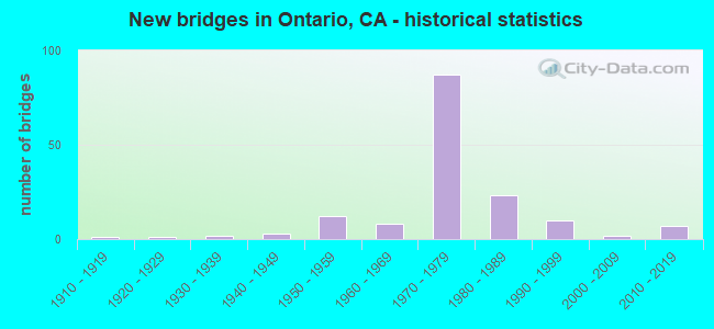
- New bridges - historical statistics
- 11910-1919
- 11920-1929
- 21930-1939
- 31940-1949
- 121950-1959
- 81960-1969
- 871970-1979
- 231980-1989
- 101990-1999
- 22000-2009
- 72010-2019

- Reconstructed bridges - Historical Statistics
- 21940-1949
- 11950-1959
- 41960-1969
- 21970-1979
- 41980-1989
- 161990-1999
- 42000-2009
- 22010-2019


- Bridge Condition - Deck
- 66.7%Good
- 33.3%Fair

- Bridge Condition - Superstructure
- 69.3%Good
- 4.0%Satisfactory
- 26.7%Fair

- Bridge Condition - Substructure
- 88.0%Good
- 1.3%Satisfactory
- 10.7%Fair

- Bridge Condition - Channel
- 63.3%Excellent
- 20.0%Very good
- 10.0%Good
- 6.7%Satisfactory

- Bridge Condition - Culverts
- 41.7%Good
- 58.3%Satisfactory
Find on map >> Show street view
Structure Number: 54 0351, Location: 08-SBD-010-10.12-ONT (Lat: 34.067336, Lng: -117.541753), Route carried "on" structure: Interstate 10, Year Built: 1943, Year Reconstructed: 1975, Status: Open, Structure Length: 2.62m (8.60ft), Average Daily Traffic: 245,300 (year 2016), Truck Traffic: 12%, Average Future Daily Traffic: 311,000 (year 2038), Design Load: HS 20, Features Intersected: DAY CANYON CHANNEL
Minimum Vertical Clearance: 30+ m (98+ ft), Kilometerpoint: 10.120, Lanes on structure: 10, Base Highway Network: Yes (, Subroute: 1), Owner: State Highway Agency, Approaching Roadway Width: 53.9m (176.8ft), Skew: 30 degrees, Material/Design: Concrete continuous, Design/Construction: Slab, Number Of Spans In Main Unit: 3, Length of Maximum Span: 8.8m (28.9ft), Curb-To-Curb Width: 53.9m (176.8ft), Out-to-Out Width: 55.5m (182.1ft)
Condition: Deck: Good, Superstructure: Good, Substructure: Good, Channel: Excellent, Operating Rating: 44.7 metric tons, Method Used To Determine Operating Rating: Load Factor (LF), Inventory Rating: 26.9 metric tons, Method Used To Determine Inventory Rating: Load Factor (LF), Structural Evaluation: Equal to present minimum criteria, Deck Geometry: Superior to present desirable criteria, Waterway Adequacy: Equal to present desirable criteria, Approach Roadway Alignment: Equal to present desirable criteria, Designated Inspection Frequency: Every 24 months, Inspection Date: June 2021, Deck Structure Type: Concrete Cast-file-Place
Find on map >> Show street view
Structure Number: 54 0351F, Location: 08-SBD-010-10.12-ONT (Lat: 34.067864, Lng: -117.541811), Route carried "on" structure: Ramp Interstate 10, Year Built: 1975, Status: Open, Structure Length: 3.96m (12.99ft), Average Daily Traffic: 29,000 (year 2016), Truck Traffic: 11%, Average Future Daily Traffic: 40,000 (year 2038), Design Load: HS 20, Features Intersected: DAY CANYON CHANNEL
Minimum Vertical Clearance: 30+ m (98+ ft), Kilometerpoint: 10.120, Lanes on structure: 2, Base Highway Network: Yes (, Subroute: 1), Owner: State Highway Agency, Approaching Roadway Width: 11.0m (36.1ft), Material/Design: Prestressed concrete, Design/Construction: Box Beam or Girders - Multiple, Number Of Spans In Main Unit: 1, Length of Maximum Span: 39.3m (128.9ft), Curb-To-Curb Width: 11.0m (36.1ft), Out-to-Out Width: 11.6m (38.1ft)
Condition: Deck: Good, Superstructure: Good, Substructure: Good, Channel: Excellent, Operating Rating: 41.8 metric tons, Method Used To Determine Operating Rating: Load and Resistance Factor Rating (LRFR) rating reported by rating factor(RF) method using HL-93 loadings, Inventory Rating: 30.8 metric tons, Method Used To Determine Inventory Rating: Load and Resistance Factor Rating (LRFR) rating reported by rating factor(RF) method using HL-93 loadings, Structural Evaluation: Better than present minimum criteria, Deck Geometry: Better than present minimum criteria, Waterway Adequacy: Equal to present desirable criteria, Approach Roadway Alignment: Equal to present desirable criteria, Designated Inspection Frequency: Every 24 months, Inspection Date: June 2021, Deck Structure Type: Concrete Cast-file-Place
Find on map >> Show street view
Structure Number: 54 0378L, Location: 08-SBD-010-10.99-ONT (Lat: 34.067500, Lng: -117.526550), Route carried "on" structure: Interstate 10, Year Built: 1947, Year Reconstructed: 1966, Status: Open, Structure Length: 1.25m (4.10ft), Average Daily Traffic: 129,000 (year 2017), Truck Traffic: 11%, Average Future Daily Traffic: 150,000 (year 2039), Features Intersected: ETIWANDA WASH
Minimum Vertical Clearance: 30+ m (98+ ft), Kilometerpoint: 10.990, Lanes on structure: 6, Base Highway Network: Yes (, Subroute: 1), Owner: State Highway Agency, Approaching Roadway Width: 34.4m (112.9ft), Skew: 21 degrees, Material/Design: Concrete, Design/Construction: Frame, Number Of Spans In Main Unit: 1, Length of Maximum Span: 11.9m (39.0ft), Curb-To-Curb Width: 34.4m (112.9ft), Out-to-Out Width: 35.0m (114.8ft)
Condition: Deck: Fair, Superstructure: Fair, Substructure: Good, Channel: Very good, Operating Rating: 79.7 metric tons, Method Used To Determine Operating Rating: Load Factor (LF), Inventory Rating: 48.0 metric tons, Method Used To Determine Inventory Rating: Load Factor (LF), Structural Evaluation: Somewhat better than minimum adequacy, Deck Geometry: Superior to present desirable criteria, Waterway Adequacy: Better than present minimum criteria, Approach Roadway Alignment: Equal to present desirable criteria, Designated Inspection Frequency: Every 24 months, Inspection Date: June 2021, Deck Structure Type: Concrete Cast-file-Place
Find on map >> Show street view
Structure Number: 54 0378R, Location: 08-SBD-010-10.99-ONT (Lat: 34.067203, Lng: -117.526644), Route carried "on" structure: Interstate 10, Year Built: 1939, Year Reconstructed: 1966, Status: Open, Structure Length: 1.25m (4.10ft), Average Daily Traffic: 129,000 (year 2017), Truck Traffic: 11%, Average Future Daily Traffic: 150,000 (year 2039), Design Load: H 15, Features Intersected: ETIWANDA WASH
Minimum Vertical Clearance: 30+ m (98+ ft), Kilometerpoint: 10.990, Lanes on structure: 5, Base Highway Network: Yes (, Subroute: 1), Owner: State Highway Agency, Approaching Roadway Width: 30.7m (100.7ft), Skew: 21 degrees, Material/Design: Concrete, Design/Construction: Frame, Number Of Spans In Main Unit: 1, Length of Maximum Span: 11.9m (39.0ft), Curb-To-Curb Width: 30.7m (100.7ft), Out-to-Out Width: 33.7m (110.6ft)
Condition: Deck: Fair, Superstructure: Fair, Substructure: Fair, Channel: Very good, Operating Rating: 50.9 metric tons, Method Used To Determine Operating Rating: Load Factor (LF), Inventory Rating: 30.8 metric tons, Method Used To Determine Inventory Rating: Load Factor (LF), Structural Evaluation: Somewhat better than minimum adequacy, Deck Geometry: Superior to present desirable criteria, Waterway Adequacy: Better than present minimum criteria, Approach Roadway Alignment: Equal to present desirable criteria, Designated Inspection Frequency: Every 24 months, Inspection Date: June 2021, Deck Structure Type: Concrete Cast-file-Place
Find on map >> Show street view
Structure Number: 54 0378S, Location: 08-SBD-010-10.99-ONT (Lat: 34.066994, Lng: -117.526706), Route carried "on" structure: Ramp Interstate 10, Year Built: 1966, Status: Open, Structure Length: 1.19m (3.90ft), Average Daily Traffic: 12,000 (year 2016), Truck Traffic: 36%, Average Future Daily Traffic: 18,000 (year 2038), Design Load: HS 20, Features Intersected: ETIWANDA WASH
Minimum Vertical Clearance: 30+ m (98+ ft), Kilometerpoint: 10.990, Lanes on structure: 1, Base Highway Network: Yes (, Subroute: 1), Owner: State Highway Agency, Approaching Roadway Width: 6.8m (22.3ft), Material/Design: Concrete, Design/Construction: Frame, Number Of Spans In Main Unit: 1, Length of Maximum Span: 11.6m (38.1ft), Curb or Sidewalk Widths: Left: 0.6m (2.0ft), Right: 0.0m, Curb-To-Curb Width: 6.8m (22.3ft), Out-to-Out Width: 8.0m (26.2ft)
Condition: Deck: Good, Superstructure: Good, Substructure: Fair, Channel: Very good, Operating Rating: 78.1 metric tons, Method Used To Determine Operating Rating: Load Factor (LF), Inventory Rating: 47.0 metric tons, Method Used To Determine Inventory Rating: Load Factor (LF), Structural Evaluation: Somewhat better than minimum adequacy, Deck Geometry: Equal to present minimum criteria, Waterway Adequacy: Better than present minimum criteria, Approach Roadway Alignment: Equal to present minimum criteria, Designated Inspection Frequency: Every 24 months, Inspection Date: June 2021, Deck Structure Type: Concrete Cast-file-Place
Find on map >> Show street view
Structure Number: 54 0434, Location: 08-SBD-010-11.82-SBD (Lat: 34.066636, Lng: -117.512153), Route carried "on" structure: Interstate 10, Year Built: 1947, Year Reconstructed: 1965, Status: Open, Structure Length: 0.82m (2.69ft), Average Daily Traffic: 250,000 (year 2018), Truck Traffic: 10%, Average Future Daily Traffic: 285,000 (year 2040), Features Intersected: SAN SEVAINE CREEK
Minimum Vertical Clearance: 30+ m (98+ ft), Kilometerpoint: 11.820, Lanes on structure: 9, Base Highway Network: Yes (, Subroute: 1), Owner: State Highway Agency, Approaching Roadway Width: 45.0m (147.6ft), Skew: 31 degrees, Material/Design: Concrete continuous, Design/Construction: Culvert, Number Of Spans In Main Unit: 3, Length of Maximum Span: 2.4m (7.9ft)
Condition: Channel: Very good, Culverts: Good, Operating Rating: 54.1 metric tons, Method Used To Determine Operating Rating: Field evaluation and documented engineering judgment, Inventory Rating: 32.4 metric tons, Method Used To Determine Inventory Rating: Field evaluation and documented engineering judgment, Structural Evaluation: Better than present minimum criteria, Waterway Adequacy: Superior to present desirable criteria, Approach Roadway Alignment: Equal to present desirable criteria, Designated Inspection Frequency: Every 24 months, Inspection Date: April 2020
Find on map >> Show street view
Structure Number: 54 0437L, Location: 08-SBD-010-6.80-ONT (Lat: 34.067908, Lng: -117.599286), Route carried "on" structure: Interstate 10, Year Built: 1966, Year Reconstructed: 1998, Status: Open, Structure Length: 7.10m (23.29ft), Average Daily Traffic: 126,000 (year 2017), Truck Traffic: 7%, Average Future Daily Traffic: 135,000 (year 2039), Design Load: HS 20+Mod, Features Intersected: W10-HOLT BLVD OFF-RAMP
Minimum Vertical Clearance: 30+ m (98+ ft), Kilometerpoint: 6.800, Lanes on structure: 5, Lanes under structure: 2, Base Highway Network: Yes (, Subroute: 1), Owner: State Highway Agency, Approaching Roadway Width: 24.5m (80.4ft), Skew: 6 degrees, Material/Design: Concrete continuous, Design/Construction: Box Beam or Girders - Multiple, Number Of Spans In Main Unit: 3, Length of Maximum Span: 28.7m (94.2ft), Curb-To-Curb Width: 24.5m (80.4ft), Out-to-Out Width: 25.3m (83.0ft)
Condition: Deck: Good, Superstructure: Good, Substructure: Good, Operating Rating: 54.1 metric tons, Method Used To Determine Operating Rating: Assigned rating based on Load Factor Design (LFD) reported in metric tons, Inventory Rating: 32.4 metric tons, Method Used To Determine Inventory Rating: Assigned rating based on Load Factor Design (LFD) reported in metric tons, Structural Evaluation: Better than present minimum criteria, Deck Geometry: Equal to present minimum criteria, Underclear: Superior to present desirable criteria, Approach Roadway Alignment: Equal to present desirable criteria, Designated Inspection Frequency: Every 24 months, Inspection Date: May 2021, Deck Structure Type: Concrete Cast-file-Place
Find on map >> Show street view
Structure Number: 54 0437R, Location: 08-SBD-010-6.80-ONT (Lat: 34.067378, Lng: -117.599933), Route carried "on" structure: Interstate 10, Year Built: 1953, Year Reconstructed: 1998, Status: Open, Structure Length: 2.87m (9.42ft), Average Daily Traffic: 126,000 (year 2017), Truck Traffic: 7%, Average Future Daily Traffic: 135,000 (year 2039), Design Load: HS 20+Mod, Features Intersected: W10-HOLT BLVD OFF-RAMP
Minimum Vertical Clearance: 30+ m (98+ ft), Kilometerpoint: 6.800, Lanes on structure: 7, Lanes under structure: 2, Base Highway Network: Yes (, Subroute: 1), Owner: State Highway Agency, Approaching Roadway Width: 35.1m (115.2ft), Skew: 5 degrees, Material/Design: Concrete, Design/Construction: Box Beam or Girders - Multiple, Number Of Spans In Main Unit: 1, Length of Maximum Span: 26.8m (87.9ft), Curb-To-Curb Width: 35.1m (115.2ft), Out-to-Out Width: 36.1m (118.4ft)
Condition: Deck: Good, Superstructure: Satisfactory, Substructure: Good, Operating Rating: 54.1 metric tons, Method Used To Determine Operating Rating: Assigned rating based on Load Factor Design (LFD) reported in metric tons, Inventory Rating: 32.4 metric tons, Method Used To Determine Inventory Rating: Assigned rating based on Load Factor Design (LFD) reported in metric tons, Structural Evaluation: Equal to present minimum criteria, Deck Geometry: Superior to present desirable criteria, Underclear: Better than present minimum criteria, Approach Roadway Alignment: Equal to present desirable criteria, Designated Inspection Frequency: Every 24 months, Inspection Date: May 2021, Deck Structure Type: Concrete Cast-file-Place
Find on map >> Show street view
Structure Number: 54 0438L, Location: 08-SBD-010-6.70-ONT (Lat: 34.068067, Lng: -117.601283), Route carried "on" structure: Interstate 10, Year Built: 1953, Year Reconstructed: 1999, Status: Open, Structure Length: 2.93m (9.61ft), Average Daily Traffic: 126,000 (year 2017), Truck Traffic: 7%, Average Future Daily Traffic: 135,000 (year 2039), Design Load: HS 20+Mod, Features Intersected: CUCAMONGA WASH
Minimum Vertical Clearance: 30+ m (98+ ft), Kilometerpoint: 6.700, Lanes on structure: 6, Base Highway Network: Yes (, Subroute: 1), Owner: State Highway Agency, Approaching Roadway Width: 28.0m (91.9ft), Material/Design: Concrete continuous, Design/Construction: Tee Beam, Number Of Spans In Main Unit: 2, Length of Maximum Span: 14.6m (47.9ft), Curb-To-Curb Width: 28.0m (91.9ft), Out-to-Out Width: 29.0m (95.1ft)
Condition: Deck: Fair, Superstructure: Good, Substructure: Good, Channel: Very good, Operating Rating: 54.1 metric tons, Method Used To Determine Operating Rating: Assigned rating based on Load Factor Design (LFD) reported in metric tons, Inventory Rating: 32.4 metric tons, Method Used To Determine Inventory Rating: Assigned rating based on Load Factor Design (LFD) reported in metric tons, Structural Evaluation: Better than present minimum criteria, Deck Geometry: Equal to present minimum criteria, Waterway Adequacy: Equal to present desirable criteria, Approach Roadway Alignment: Superior to present desirable criteria, Designated Inspection Frequency: Every 24 months, Inspection Date: May 2021, Deck Structure Type: Concrete Cast-file-Place
Find on map >> Show street view
Structure Number: 54 0438R, Location: 08-SBD-010-6.70-ONT (Lat: 34.067561, Lng: -117.601361), Route carried "on" structure: Interstate 10, Year Built: 1953, Year Reconstructed: 1999, Status: Open, Structure Length: 2.93m (9.61ft), Average Daily Traffic: 126,000 (year 2017), Truck Traffic: 7%, Average Future Daily Traffic: 135,000 (year 2039), Design Load: HS 20, Features Intersected: CUCAMONGA WASH
Minimum Vertical Clearance: 30+ m (98+ ft), Kilometerpoint: 6.700, Lanes on structure: 6, Base Highway Network: Yes (, Subroute: 1), Owner: State Highway Agency, Approaching Roadway Width: 28.0m (91.9ft), Material/Design: Concrete continuous, Design/Construction: Tee Beam, Number Of Spans In Main Unit: 2, Length of Maximum Span: 14.6m (47.9ft), Curb-To-Curb Width: 28.0m (91.9ft), Out-to-Out Width: 29.0m (95.1ft)
Condition: Deck: Good, Superstructure: Good, Substructure: Good, Channel: Very good, Operating Rating: 46.0 metric tons, Method Used To Determine Operating Rating: Load Factor (LF), Inventory Rating: 27.5 metric tons, Method Used To Determine Inventory Rating: Load Factor (LF), Structural Evaluation: Equal to present minimum criteria, Deck Geometry: Equal to present minimum criteria, Waterway Adequacy: Equal to present desirable criteria, Approach Roadway Alignment: Equal to present desirable criteria, Designated Inspection Frequency: Every 24 months, Inspection Date: May 2021, Deck Structure Type: Concrete Cast-file-Place
Find on map >> Show street view
Structure Number: 54 0439, Location: 08-SBD-010-6.10-ONT (Lat: 34.071092, Lng: -117.611347), Route carried "on" structure: City street R194, Year Built: 1971, Status: Open, Structure Length: 7.92m (25.98ft), Average Daily Traffic: 30,000 (year 2019), Truck Traffic: 2%, Average Future Daily Traffic: 50,000 (year 2041), Design Load: HS 20, Features Intersected: INTERSTATE 10, Facility Carried by Structure: VINEYARD AVENUE
Minimum Vertical Clearance: 30+ m (98+ ft), Kilometerpoint: 6.100, Lanes on structure: 6, Lanes under structure: 11, Owner: State Highway Agency, Approaching Roadway Width: 23.2m (76.1ft), Skew: 29 degrees, Material/Design: Prestressed concrete continuous, Design/Construction: Stringer/Multi-beam, Number Of Spans In Main Unit: 2, Number Of Approach Spans: 2, Length of Maximum Span: 31.4m (103.0ft), Curb or Sidewalk Widths: Left: 1.5m (4.9ft), Right: 1.5m (4.9ft), Curb-To-Curb Width: 23.2m (76.1ft), Out-to-Out Width: 26.8m (87.9ft)
Condition: Deck: Good, Superstructure: Good, Substructure: Good, Operating Rating: 79.4 metric tons, Method Used To Determine Operating Rating: Load Factor (LF), Inventory Rating: 32.4 metric tons, Method Used To Determine Inventory Rating: Load Factor (LF), Structural Evaluation: Better than present minimum criteria, Deck Geometry: Meets minimum limits, Underclear: Meets minimum limits, Approach Roadway Alignment: Equal to present desirable criteria, Designated Inspection Frequency: Every 24 months, Inspection Date: May 2021, Deck Structure Type: Concrete Cast-file-Place
Find on map >> Show street view
Structure Number: 54 0441, Location: 08-SBD-010-4.88-ONT (Lat: 34.080428, Lng: -117.628689), Route carried "on" structure: Interstate 10, Year Built: 1954, Year Reconstructed: 1999, Status: Open, Structure Length: 2.54m (8.33ft), Average Daily Traffic: 263,000 (year 2017), Truck Traffic: 7%, Average Future Daily Traffic: 265,000 (year 2039), Design Load: HS 20, Features Intersected: GROVE AVENUE
Minimum Vertical Clearance: 30+ m (98+ ft), Kilometerpoint: 4.880, Lanes on structure: 10, Lanes under structure: 4, Base Highway Network: Yes (, Subroute: 1), Owner: State Highway Agency, Approaching Roadway Width: 48.4m (158.8ft), Skew: 33 degrees, Material/Design: Concrete, Design/Construction: Box Beam or Girders - Multiple, Number Of Spans In Main Unit: 1, Number Of Approach Spans: 1, Length of Maximum Span: 24.8m (81.4ft), Curb-To-Curb Width: 48.4m (158.8ft), Out-to-Out Width: 50.2m (164.7ft)
Condition: Deck: Good, Superstructure: Good, Substructure: Satisfactory, Operating Rating: 54.1 metric tons, Method Used To Determine Operating Rating: Assigned rating based on Load Factor Design (LFD) reported in metric tons, Inventory Rating: 32.4 metric tons, Method Used To Determine Inventory Rating: Assigned rating based on Load Factor Design (LFD) reported in metric tons, Structural Evaluation: Equal to present minimum criteria, Deck Geometry: Superior to present desirable criteria, Underclear: Meets minimum limits, Approach Roadway Alignment: Equal to present desirable criteria, Designated Inspection Frequency: Every 24 months, Inspection Date: May 2021, Deck Structure Type: Concrete Cast-file-Place
Find on map >> Show street view
Structure Number: 54 0442, Location: 08-SBD-010-4.33-ONT (Lat: 34.085306, Lng: -117.636175), Route carried "on" structure: City street , Year Built: 1971, Status: Open, Structure Length: 10.06m (33.01ft), Average Daily Traffic: 10,000 (year 2019), Truck Traffic: 2%, Average Future Daily Traffic: 20,000 (year 2041), Design Load: HS 20, Features Intersected: INTERSTATE 10, Facility Carried by Structure: SIXTH STREET
Minimum Vertical Clearance: 30+ m (98+ ft), Kilometerpoint: 0.000, Lanes on structure: 2, Lanes under structure: 10, Owner: State Highway Agency, Approaching Roadway Width: 12.2m (40.0ft), Skew: 5 degrees, Material/Design: Prestressed concrete continuous, Design/Construction: Box Beam or Girders - Multiple, Number Of Spans In Main Unit: 2, Length of Maximum Span: 47.9m (157.2ft), Curb or Sidewalk Widths: Left: 1.5m (4.9ft), Right: 1.5m (4.9ft), Curb-To-Curb Width: 12.2m (40.0ft), Out-to-Out Width: 15.8m (51.8ft)
Condition: Deck: Good, Superstructure: Satisfactory, Substructure: Good, Operating Rating: 97.5 metric tons, Method Used To Determine Operating Rating: Load Factor (LF), Inventory Rating: 32.4 metric tons, Method Used To Determine Inventory Rating: Load Factor (LF), Structural Evaluation: Equal to present minimum criteria, Deck Geometry: Somewhat better than minimum adequacy, Underclear: High priority of corrective action, Approach Roadway Alignment: Equal to present desirable criteria, Designated Inspection Frequency: Every 24 months, Inspection Date: May 2021, Deck Structure Type: Concrete Cast-file-Place
Find on map >> Show street view
Structure Number: 54 0443, Location: 08-SBD-010-4.02-ONT (Lat: 34.087308, Lng: -117.641564), Route carried "on" structure: City street , Year Built: 1971, Status: Open, Structure Length: 7.25m (23.79ft), Average Daily Traffic: 8,000 (year 2019), Truck Traffic: 2%, Average Future Daily Traffic: 12,202 (year 2041), Design Load: HS 20, Features Intersected: INTERSTATE 10, Facility Carried by Structure: CAMPUS AVENUE
Minimum Vertical Clearance: 30+ m (98+ ft), Kilometerpoint: 0.000, Lanes on structure: 2, Lanes under structure: 10, Owner: State Highway Agency, Approaching Roadway Width: 12.2m (40.0ft), Skew: 1 degrees, Material/Design: Prestressed concrete continuous, Design/Construction: Stringer/Multi-beam, Number Of Spans In Main Unit: 2, Number Of Approach Spans: 2, Length of Maximum Span: 27.4m (89.9ft), Curb or Sidewalk Widths: Left: 1.5m (4.9ft), Right: 1.5m (4.9ft), Curb-To-Curb Width: 12.2m (40.0ft), Out-to-Out Width: 15.8m (51.8ft)
Condition: Deck: Good, Superstructure: Good, Substructure: Good, Operating Rating: 80.0 metric tons, Method Used To Determine Operating Rating: Load Factor (LF), Inventory Rating: 32.4 metric tons, Method Used To Determine Inventory Rating: Load Factor (LF), Structural Evaluation: Better than present minimum criteria, Deck Geometry: Somewhat better than minimum adequacy, Underclear: Meets minimum limits, Approach Roadway Alignment: Equal to present desirable criteria, Designated Inspection Frequency: Every 48 months, Inspection Date: May 2021, Deck Structure Type: Concrete Cast-file-Place
Find on map >> Show street view
Structure Number: 54 046, Location: 08-SBD-010-R22.86-COL (Lat: 34.065233, Lng: -117.320225), Route carried "on" structure: Interstate 10, Year Built: 1956, Year Reconstructed: 1970, Status: Open, Structure Length: 0.79m (2.59ft), Average Daily Traffic: 204,000 (year 2017), Truck Traffic: 11%, Average Future Daily Traffic: 210,000 (year 2039), Design Load: HS 20, Features Intersected: UP RR SPUR
Minimum Vertical Clearance: 30+ m (98+ ft), Kilometerpoint: 22.860, Lanes on structure: 10, Base Highway Network: Yes (, Subroute: 1), Owner: State Highway Agency, Approaching Roadway Width: 59.7m (195.9ft), Skew: 39 degrees, Material/Design: Concrete, Design/Construction: Frame, Number Of Spans In Main Unit: 1, Length of Maximum Span: 6.4m (21.0ft), Curb-To-Curb Width: 59.7m (195.9ft), Out-to-Out Width: 61.3m (201.1ft)
Condition: Deck: Fair, Superstructure: Fair, Substructure: Good, Operating Rating: 52.5 metric tons, Method Used To Determine Operating Rating: Load Factor (LF), Inventory Rating: 31.8 metric tons, Method Used To Determine Inventory Rating: Load Factor (LF), Structural Evaluation: Somewhat better than minimum adequacy, Deck Geometry: Superior to present desirable criteria, Underclear: Meets minimum limits, Approach Roadway Alignment: Equal to present desirable criteria, Designated Inspection Frequency: Every 24 months, Inspection Date: July 2021, Deck Structure Type: Concrete Cast-file-Place
Find on map >> Show street view
Structure Number: 54 0463, Location: 08-SBD-010-11.13-ONT (Lat: 34.066942, Lng: -117.524206), Route carried "on" structure: City street R056, Year Built: 1955, Year Reconstructed: 1966, Status: Open, Structure Length: 11.73m (38.48ft), Average Daily Traffic: 20,000 (year 2016), Truck Traffic: 11%, Average Future Daily Traffic: 27,500 (year 2038), Design Load: HS 20, Features Intersected: INTERSTATE 10, Facility Carried by Structure: ETIWANDA AVENUE
Minimum Vertical Clearance: 30+ m (98+ ft), Kilometerpoint: 0.000, Lanes on structure: 6, Lanes under structure: 12, Base Highway Network: Yes, Owner: State Highway Agency, Approaching Roadway Width: 24.6m (80.7ft), Skew: 20 degrees, Material/Design: Steel, Design/Construction: Stringer/Multi-beam, Number Of Spans In Main Unit: 5, Number Of Approach Spans: 2, Length of Maximum Span: 27.4m (89.9ft), Curb or Sidewalk Widths: Left: 0.5m (1.6ft), Right: 0.5m (1.6ft), Curb-To-Curb Width: 24.6m (80.7ft), Out-to-Out Width: 26.5m (86.9ft)
Condition: Deck: Fair, Superstructure: Good, Substructure: Good, Operating Rating: 68.4 metric tons, Method Used To Determine Operating Rating: Load Factor (LF), Inventory Rating: 41.1 metric tons, Method Used To Determine Inventory Rating: Load Factor (LF), Structural Evaluation: Better than present minimum criteria, Deck Geometry: Somewhat better than minimum adequacy, Underclear: Meets minimum limits, Approach Roadway Alignment: Equal to present desirable criteria, Designated Inspection Frequency: Every 24 months, Inspection Date: June 2021, Deck Structure Type: Concrete Cast-file-Place
Find on map >> Show street view
Structure Number: 54 053, Location: 08-SBD-215-2.69-COL (Lat: 34.047594, Lng: -117.307583), Route carried "on" structure: City street R040, Year Built: 1959, Year Reconstructed: 1993, Status: Open, Structure Length: 6.19m (20.31ft), Average Daily Traffic: 25,000 (year 2014), Truck Traffic: 5%, Average Future Daily Traffic: 38,896 (year 2042), Design Load: HS 20, Features Intersected: INTERSTATE 215 & RAMPS, Facility Carried by Structure: WASHINGTON AVENUE
Minimum Vertical Clearance: 30+ m (98+ ft), Kilometerpoint: 0.000, Lanes on structure: 5, Lanes under structure: 10, Base Highway Network: Yes, Owner: State Highway Agency, Approaching Roadway Width: 17.1m (56.1ft), Skew: 1 degrees, Material/Design: Concrete continuous, Design/Construction: Tee Beam, Number Of Spans In Main Unit: 4, Length of Maximum Span: 21.9m (71.9ft), Curb or Sidewalk Widths: Left: 1.4m (4.6ft), Right: 0.0m, Curb-To-Curb Width: 17.1m (56.1ft), Out-to-Out Width: 20.0m (65.6ft)
Condition: Deck: Fair, Superstructure: Fair, Substructure: Good, Operating Rating: 29.2 metric tons, Method Used To Determine Operating Rating: Load and Resistance Factor Rating (LRFR) rating reported by rating factor(RF) method using HL-93 loadings, Inventory Rating: 22.4 metric tons, Method Used To Determine Inventory Rating: Load and Resistance Factor Rating (LRFR) rating reported by rating factor(RF) method using HL-93 loadings, Structural Evaluation: Somewhat better than minimum adequacy, Deck Geometry: High priority of replacement, Underclear: High priority of corrective action, Approach Roadway Alignment: Meets minimum limits, Designated Inspection Frequency: Every 24 months, Inspection Date: January 2022, Deck Structure Type: Concrete Cast-file-Place
Find on map >> Show street view
Structure Number: 54 0539, Location: 08-SBD-010-9.17-ONT (Lat: 34.067144, Lng: -117.558356), Route carried "on" structure: City street , Year Built: 1971, Year Reconstructed: 2000, Status: Open, Structure Length: 10.06m (33.01ft), Average Daily Traffic: 30,500 (year 2017), Truck Traffic: 11%, Average Future Daily Traffic: 52,000 (year 2039), Design Load: HS 20+Mod, Features Intersected: INTERSTATE 10, Facility Carried by Structure: MILLIKEN AVENUE
Minimum Vertical Clearance: 30+ m (98+ ft), Kilometerpoint: 0.000, Lanes on structure: 10, Lanes under structure: 14, Owner: State Highway Agency, Approaching Roadway Width: 40.2m (131.9ft), Material/Design: Prestressed concrete continuous, Design/Construction: Box Beam or Girders - Multiple, Number Of Spans In Main Unit: 3, Length of Maximum Span: 41.1m (134.8ft), Curb or Sidewalk Widths: Left: 0.0m, Right: 1.5m (4.9ft), Curb-To-Curb Width: 40.2m (131.9ft), Out-to-Out Width: 42.6m (139.8ft)
Condition: Deck: Fair, Superstructure: Good, Substructure: Good, Operating Rating: 54.1 metric tons, Method Used To Determine Operating Rating: Assigned rating based on Load Factor Design (LFD) reported in metric tons, Inventory Rating: 32.4 metric tons, Method Used To Determine Inventory Rating: Assigned rating based on Load Factor Design (LFD) reported in metric tons, Structural Evaluation: Better than present minimum criteria, Deck Geometry: Somewhat better than minimum adequacy, Underclear: Meets minimum limits, Approach Roadway Alignment: Equal to present desirable criteria, Designated Inspection Frequency: Every 24 months, Inspection Date: June 2021, Deck Structure Type: Concrete Cast-file-Place
Find on map >> Show street view
Structure Number: 54 0560R, Location: 08-SBD-010-8.16-ONT (Lat: 34.068000, Lng: -117.575653), Route carried "on" structure: City street , Year Built: 1993, Status: Open, Structure Length: 8.29m (27.20ft), Average Daily Traffic: 21,000 (year 2017), Truck Traffic: 5%, Average Future Daily Traffic: 25,000 (year 2039), Design Load: HS 20+Mod, Features Intersected: INTERSTATE 10, Facility Carried by Structure: HAVEN AVENUE (NB)
Minimum Vertical Clearance: 30+ m (98+ ft), Kilometerpoint: 0.000, Lanes on structure: 4, Lanes under structure: 12, Base Highway Network: Yes, Owner: State Highway Agency, Approaching Roadway Width: 17.7m (58.1ft), Material/Design: Prestressed concrete continuous, Design/Construction: Box Beam or Girders - Multiple, Number Of Spans In Main Unit: 2, Length of Maximum Span: 41.1m (134.8ft), Curb or Sidewalk Widths: Left: 0.0m, Right: 1.5m (4.9ft), Curb-To-Curb Width: 17.7m (58.1ft), Out-to-Out Width: 20.1m (65.9ft)
Condition: Deck: Good, Superstructure: Good, Substructure: Good, Operating Rating: 54.1 metric tons, Method Used To Determine Operating Rating: Assigned rating based on Load Factor Design (LFD) reported in metric tons, Inventory Rating: 32.4 metric tons, Method Used To Determine Inventory Rating: Assigned rating based on Load Factor Design (LFD) reported in metric tons, Structural Evaluation: Better than present minimum criteria, Deck Geometry: Somewhat better than minimum adequacy, Underclear: Meets minimum limits, Approach Roadway Alignment: Equal to present desirable criteria, Designated Inspection Frequency: Every 24 months, Inspection Date: June 2021, Deck Structure Type: Concrete Cast-file-Place
Find on map >> Show street view
Structure Number: 54 075, Location: 08-SBD-060-R4.10-CHN (Lat: 34.030183, Lng: -117.659156), Route carried "on" structure: State highway 60, Year Built: 1970, Year Reconstructed: 1997, Status: Open, Structure Length: 4.40m (14.44ft), Average Daily Traffic: 224,000 (year 2017), Truck Traffic: 13%, Average Future Daily Traffic: 275,000 (year 2040), Design Load: HS 20+Mod, Features Intersected: SAN ANTONIO AVE
Minimum Vertical Clearance: 30+ m (98+ ft), Kilometerpoint: 4.100, Lanes on structure: 10, Lanes under structure: 4, Base Highway Network: Yes (, Subroute: 1), Owner: State Highway Agency, Approaching Roadway Width: 48.5m (159.1ft), Skew: 30 degrees, Material/Design: Concrete continuous, Design/Construction: Box Beam or Girders - Multiple, Number Of Spans In Main Unit: 3, Length of Maximum Span: 24.0m (78.7ft), Curb-To-Curb Width: 48.5m (159.1ft), Out-to-Out Width: 50.0m (164.0ft)
Condition: Deck: Fair, Superstructure: Good, Substructure: Good, Operating Rating: 54.1 metric tons, Method Used To Determine Operating Rating: Assigned rating based on Load Factor Design (LFD) reported in metric tons, Inventory Rating: 32.4 metric tons, Method Used To Determine Inventory Rating: Assigned rating based on Load Factor Design (LFD) reported in metric tons, Structural Evaluation: Better than present minimum criteria, Deck Geometry: Superior to present desirable criteria, Underclear: Better than present minimum criteria, Approach Roadway Alignment: Superior to present desirable criteria, Designated Inspection Frequency: Every 24 months, Inspection Date: September 2021, Deck Structure Type: Concrete Cast-file-Place
Find on map >> Show street view
Structure Number: 54 0751, Location: 08-SBD-060-R4.56-ONT (Lat: 34.030208, Lng: -117.651247), Route carried "on" structure: State highway 60, Year Built: 1970, Year Reconstructed: 1997, Status: Open, Structure Length: 7.60m (24.93ft), Average Daily Traffic: 228,000 (year 2017), Truck Traffic: 13%, Average Future Daily Traffic: 260,000 (year 2040), Design Load: HS 20+Mod, Features Intersected: ST RTE 83 (EUCLID AVE)
Minimum Vertical Clearance: 30+ m (98+ ft), Kilometerpoint: 4.560, Lanes on structure: 10, Lanes under structure: 6, Base Highway Network: Yes (, Subroute: 1), Owner: State Highway Agency, Approaching Roadway Width: 48.5m (159.1ft), Skew: 30 degrees, Material/Design: Concrete continuous, Design/Construction: Box Beam or Girders - Multiple, Number Of Spans In Main Unit: 2, Length of Maximum Span: 38.0m (124.7ft), Curb-To-Curb Width: 48.5m (159.1ft), Out-to-Out Width: 50.0m (164.0ft)
Condition: Deck: Fair, Superstructure: Good, Substructure: Good, Operating Rating: 54.1 metric tons, Method Used To Determine Operating Rating: Assigned rating based on Load Factor Design (LFD) reported in metric tons, Inventory Rating: 32.4 metric tons, Method Used To Determine Inventory Rating: Assigned rating based on Load Factor Design (LFD) reported in metric tons, Structural Evaluation: Better than present minimum criteria, Deck Geometry: Superior to present desirable criteria, Underclear: Superior to present desirable criteria, Approach Roadway Alignment: Equal to present desirable criteria, Designated Inspection Frequency: Every 24 months, Inspection Date: September 2021, Deck Structure Type: Concrete Cast-file-Place
Find on map >> Show street view
Structure Number: 54 0830L, Location: 08-SBD-010-R23.60-COL (Lat: 34.065222, Lng: -117.307592), Route carried "on" structure: Interstate 10, Year Built: 1970, Status: Open, Structure Length: 11.89m (39.01ft), Average Daily Traffic: 102,000 (year 2017), Truck Traffic: 13%, Average Future Daily Traffic: 120,000 (year 2039), Design Load: HS 20, Features Intersected: WARM CREEK
Minimum Vertical Clearance: 5.79m (19.00ft), Kilometerpoint: 23.600, Lanes on structure: 5, Base Highway Network: Yes (, Subroute: 1), Owner: State Highway Agency, Approaching Roadway Width: 23.8m (78.1ft), Material/Design: Concrete continuous, Design/Construction: Box Beam or Girders - Multiple, Number Of Spans In Main Unit: 5, Length of Maximum Span: 27.4m (89.9ft), Curb-To-Curb Width: 23.8m (78.1ft), Out-to-Out Width: 24.4m (80.1ft)
Condition: Deck: Good, Superstructure: Good, Substructure: Good, Channel: Excellent, Operating Rating: 62.9 metric tons, Method Used To Determine Operating Rating: Load Factor (LF), Inventory Rating: 37.9 metric tons, Method Used To Determine Inventory Rating: Load Factor (LF), Structural Evaluation: Better than present minimum criteria, Deck Geometry: Equal to present minimum criteria, Waterway Adequacy: Superior to present desirable criteria, Approach Roadway Alignment: Equal to present desirable criteria, Designated Inspection Frequency: Every 24 months, Inspection Date: July 2021, Deck Structure Type: Concrete Cast-file-Place, Wearing Surface/Protective System: Wearing Surface: Integral Concrete
Find on map >> Show street view
Structure Number: 54 0836, Location: 08-SBD-060-R5.11-ONT (Lat: 34.030242, Lng: -117.641725), Route carried "on" structure: State highway 60, Year Built: 1972, Year Reconstructed: 1997, Status: Open, Structure Length: 3.20m (10.50ft), Average Daily Traffic: 221,000 (year 2017), Truck Traffic: 13%, Average Future Daily Traffic: 250,000 (year 2042), Design Load: HS 20+Mod, Features Intersected: CAMPUS AVENUE
Minimum Vertical Clearance: 30+ m (98+ ft), Kilometerpoint: 5.110, Lanes on structure: 10, Lanes under structure: 4, Base Highway Network: Yes (, Subroute: 1), Owner: State Highway Agency, Approaching Roadway Width: 48.5m (159.1ft), Skew: 30 degrees, Material/Design: Prestressed concrete, Design/Construction: Box Beam or Girders - Multiple, Number Of Spans In Main Unit: 1, Length of Maximum Span: 32.0m (105.0ft), Curb-To-Curb Width: 48.5m (159.1ft), Out-to-Out Width: 50.0m (164.0ft)
Condition: Deck: Good, Superstructure: Good, Substructure: Fair, Operating Rating: 54.1 metric tons, Method Used To Determine Operating Rating: Assigned rating based on Load Factor Design (LFD) reported in metric tons, Inventory Rating: 32.4 metric tons, Method Used To Determine Inventory Rating: Assigned rating based on Load Factor Design (LFD) reported in metric tons, Structural Evaluation: Somewhat better than minimum adequacy, Deck Geometry: Superior to present desirable criteria, Underclear: Meets minimum limits, Approach Roadway Alignment: Superior to present desirable criteria, Designated Inspection Frequency: Every 24 months, Inspection Date: September 2021, Deck Structure Type: Concrete Cast-file-Place
Find on map >> Show street view
Structure Number: 54 0837, Location: 08-SBD-060-R5.86-ONT (Lat: 34.030281, Lng: -117.628653), Route carried "on" structure: State highway 60, Year Built: 1972, Year Reconstructed: 1997, Status: Open, Structure Length: 3.60m (11.81ft), Average Daily Traffic: 221,000 (year 2017), Truck Traffic: 13%, Average Future Daily Traffic: 250,000 (year 2040), Design Load: HS 20+Mod, Features Intersected: GROVE AVENUE
Minimum Vertical Clearance: 30+ m (98+ ft), Kilometerpoint: 5.860, Lanes on structure: 10, Lanes under structure: 5, Base Highway Network: Yes (, Subroute: 1), Owner: State Highway Agency, Approaching Roadway Width: 48.5m (159.1ft), Skew: 30 degrees, Material/Design: Prestressed concrete, Design/Construction: Box Beam or Girders - Multiple, Number Of Spans In Main Unit: 1, Length of Maximum Span: 35.0m (114.8ft), Curb-To-Curb Width: 48.5m (159.1ft), Out-to-Out Width: 50.0m (164.0ft)
Condition: Deck: Good, Superstructure: Fair, Substructure: Good, Operating Rating: 54.1 metric tons, Method Used To Determine Operating Rating: Assigned rating based on Load Factor Design (LFD) reported in metric tons, Inventory Rating: 32.4 metric tons, Method Used To Determine Inventory Rating: Assigned rating based on Load Factor Design (LFD) reported in metric tons, Structural Evaluation: Somewhat better than minimum adequacy, Deck Geometry: Superior to present desirable criteria, Underclear: Somewhat better than minimum adequacy, Approach Roadway Alignment: Superior to present desirable criteria, Designated Inspection Frequency: Every 24 months, Inspection Date: September 2021, Deck Structure Type: Concrete Cast-file-Place
Find on map >> Show street view
Structure Number: 54 0838, Location: 08-SBD-060-R6.86-ONT (Lat: 34.030325, Lng: -117.611261), Route carried "on" structure: State highway 60, Year Built: 1972, Year Reconstructed: 1997, Status: Open, Structure Length: 3.50m (11.48ft), Average Daily Traffic: 221,000 (year 2017), Truck Traffic: 13%, Average Future Daily Traffic: 250,000 (year 2040), Design Load: HS 20+Mod, Features Intersected: VINEYARD AVENUE
Minimum Vertical Clearance: 30+ m (98+ ft), Kilometerpoint: 6.860, Lanes on structure: 10, Lanes under structure: 5, Base Highway Network: Yes (, Subroute: 1), Owner: State Highway Agency, Approaching Roadway Width: 48.5m (159.1ft), Skew: 30 degrees, Material/Design: Prestressed concrete, Design/Construction: Box Beam or Girders - Multiple, Number Of Spans In Main Unit: 1, Length of Maximum Span: 34.0m (111.5ft), Curb-To-Curb Width: 48.5m (159.1ft), Out-to-Out Width: 50.0m (164.0ft)
Condition: Deck: Good, Superstructure: Good, Substructure: Good, Operating Rating: 54.1 metric tons, Method Used To Determine Operating Rating: Assigned rating based on Load Factor Design (LFD) reported in metric tons, Inventory Rating: 32.4 metric tons, Method Used To Determine Inventory Rating: Assigned rating based on Load Factor Design (LFD) reported in metric tons, Structural Evaluation: Better than present minimum criteria, Deck Geometry: Superior to present desirable criteria, Underclear: Meets minimum limits, Approach Roadway Alignment: Superior to present desirable criteria, Designated Inspection Frequency: Every 24 months, Inspection Date: September 2021, Deck Structure Type: Concrete Cast-file-Place
Find on map >> Show street view
Structure Number: 54 084, Location: 08-SBD-060-R7.52-ONT (Lat: 34.030364, Lng: -117.599633), Route carried "on" structure: State highway 60, Year Built: 1972, Year Reconstructed: 1997, Status: Open, Structure Length: 7.10m (23.29ft), Average Daily Traffic: 221,000 (year 2017), Truck Traffic: 13%, Average Future Daily Traffic: 250,000 (year 2040), Design Load: HS 20+Mod, Features Intersected: CUCAMONGA CREEK
Minimum Vertical Clearance: 30+ m (98+ ft), Kilometerpoint: 7.520, Lanes on structure: 10, Lanes under structure: 2, Base Highway Network: Yes (, Subroute: 1), Owner: State Highway Agency, Approaching Roadway Width: 48.5m (159.1ft), Skew: 31 degrees, Material/Design: Concrete continuous, Design/Construction: Box Beam or Girders - Multiple, Number Of Spans In Main Unit: 3, Length of Maximum Span: 29.3m (96.1ft), Curb-To-Curb Width: 48.5m (159.1ft), Out-to-Out Width: 51.5m (169.0ft)
Condition: Deck: Fair, Superstructure: Good, Substructure: Good, Channel: Very good, Operating Rating: 54.1 metric tons, Method Used To Determine Operating Rating: Assigned rating based on Load Factor Design (LFD) reported in metric tons, Inventory Rating: 32.4 metric tons, Method Used To Determine Inventory Rating: Assigned rating based on Load Factor Design (LFD) reported in metric tons, Structural Evaluation: Better than present minimum criteria, Deck Geometry: Superior to present desirable criteria, Underclear: High priority of corrective action, Waterway Adequacy: Superior to present desirable criteria, Approach Roadway Alignment: Superior to present desirable criteria, Designated Inspection Frequency: Every 24 months, Inspection Date: September 2021, Deck Structure Type: Concrete Cast-file-Place
Find on map >> Show street view
Structure Number: 54 0841, Location: 08-SBD-060-R7.87-ONT (Lat: 34.030372, Lng: -117.593517), Route carried "on" structure: State highway 60, Year Built: 1972, Year Reconstructed: 1997, Status: Open, Structure Length: 4.60m (15.09ft), Average Daily Traffic: 215,000 (year 2017), Truck Traffic: 13%, Average Future Daily Traffic: 250,000 (year 2040), Design Load: HS 20+Mod, Features Intersected: ARCHIBALD AVENUE
Minimum Vertical Clearance: 30+ m (98+ ft), Kilometerpoint: 7.870, Lanes on structure: 10, Lanes under structure: 10, Base Highway Network: Yes (, Subroute: 1), Owner: State Highway Agency, Approaching Roadway Width: 48.5m (159.1ft), Skew: 30 degrees, Material/Design: Prestressed concrete continuous, Design/Construction: Box Beam or Girders - Multiple, Number Of Spans In Main Unit: 2, Length of Maximum Span: 23.0m (75.5ft), Curb-To-Curb Width: 48.5m (159.1ft), Out-to-Out Width: 50.0m (164.0ft)
Condition: Deck: Fair, Superstructure: Good, Substructure: Good, Operating Rating: 54.1 metric tons, Method Used To Determine Operating Rating: Assigned rating based on Load Factor Design (LFD) reported in metric tons, Inventory Rating: 32.4 metric tons, Method Used To Determine Inventory Rating: Assigned rating based on Load Factor Design (LFD) reported in metric tons, Structural Evaluation: Better than present minimum criteria, Deck Geometry: Superior to present desirable criteria, Underclear: Meets minimum limits, Approach Roadway Alignment: Superior to present desirable criteria, Designated Inspection Frequency: Every 24 months, Inspection Date: September 2021, Deck Structure Type: Concrete Cast-file-Place
Find on map >> Show street view
Structure Number: 54 0842, Location: 08-SBD-060-R8.37-ONT (Lat: 34.030381, Lng: -117.584839), Route carried "on" structure: State highway 60, Year Built: 1972, Year Reconstructed: 1997, Status: Open, Structure Length: 2.30m (7.55ft), Average Daily Traffic: 215,000 (year 2017), Truck Traffic: 13%, Average Future Daily Traffic: 250,000 (year 2040), Design Load: HS 20+Mod, Features Intersected: LOWER DEER CREEK
Minimum Vertical Clearance: 30+ m (98+ ft), Kilometerpoint: 8.370, Lanes on structure: 11, Base Highway Network: Yes (, Subroute: 1), Owner: State Highway Agency, Approaching Roadway Width: 52.2m (171.3ft), Skew: 30 degrees, Material/Design: Concrete continuous, Design/Construction: Slab, Number Of Spans In Main Unit: 3, Length of Maximum Span: 10.0m (32.8ft), Curb-To-Curb Width: 52.2m (171.3ft), Out-to-Out Width: 53.8m (176.5ft)
Condition: Deck: Fair, Superstructure: Fair, Substructure: Good, Channel: Very good, Operating Rating: 54.1 metric tons, Method Used To Determine Operating Rating: Assigned rating based on Load Factor Design (LFD) reported in metric tons, Inventory Rating: 32.4 metric tons, Method Used To Determine Inventory Rating: Assigned rating based on Load Factor Design (LFD) reported in metric tons, Structural Evaluation: Somewhat better than minimum adequacy, Deck Geometry: Superior to present desirable criteria, Waterway Adequacy: Equal to present desirable criteria, Approach Roadway Alignment: Equal to present desirable criteria, Designated Inspection Frequency: Every 24 months, Inspection Date: September 2021, Deck Structure Type: Concrete Cast-file-Place
Find on map >> Show street view
Structure Number: 54 0843, Location: 08-SBD-060-R8.90-ONT (Lat: 34.029325, Lng: -117.575944), Route carried "on" structure: City street R077, Year Built: 1972, Year Reconstructed: 1995, Status: Open, Structure Length: 7.07m (23.20ft), Average Daily Traffic: 21,893 (year 2015), Truck Traffic: 3%, Average Future Daily Traffic: 23,464 (year 2041), Design Load: HS 20+Mod, Features Intersected: STATE ROUTE 60, Facility Carried by Structure: HAVEN AVENUE
Minimum Vertical Clearance: 30+ m (98+ ft), Kilometerpoint: 0.000, Lanes on structure: 8, Lanes under structure: 10, Base Highway Network: Yes, Owner: State Highway Agency, Approaching Roadway Width: 34.7m (113.8ft), Skew: 1 degrees, Material/Design: Prestressed concrete continuous, Design/Construction: Box Beam or Girders - Multiple, Number Of Spans In Main Unit: 2, Length of Maximum Span: 35.1m (115.2ft), Curb or Sidewalk Widths: Left: 1.5m (4.9ft), Right: 1.5m (4.9ft), Curb-To-Curb Width: 34.7m (113.8ft), Out-to-Out Width: 38.4m (126.0ft)
Condition: Deck: Fair, Superstructure: Fair, Substructure: Good, Operating Rating: 58.0 metric tons, Method Used To Determine Operating Rating: Load and Resistance Factor Rating (LRFR) rating reported by rating factor(RF) method using HL-93 loadings, Inventory Rating: 38.6 metric tons, Method Used To Determine Inventory Rating: Load and Resistance Factor Rating (LRFR) rating reported by rating factor(RF) method using HL-93 loadings, Structural Evaluation: Somewhat better than minimum adequacy, Deck Geometry: Better than present minimum criteria, Underclear: Meets minimum limits, Approach Roadway Alignment: Superior to present desirable criteria, Designated Inspection Frequency: Every 24 months, Inspection Date: September 2021, Deck Structure Type: Concrete Cast-file-Place
Find on map >> Show street view
Structure Number: 54 0906, Location: 08-SBD-015-2.05-ONT (Lat: 34.062506, Lng: -117.545225), Route carried "on" structure: Interstate 15, Year Built: 1978, Year Reconstructed: 2011, Status: Open, Structure Length: 4.39m (14.40ft), Average Daily Traffic: 198,000 (year 2020), Truck Traffic: 10%, Average Future Daily Traffic: 251,446 (year 2042), Design Load: HS 20+Mod, Features Intersected: AIRPORT DRIVE
Minimum Vertical Clearance: 30+ m (98+ ft), Kilometerpoint: 2.050, Lanes on structure: 10, Lanes under structure: 2, Base Highway Network: Yes (, Subroute: 1), Owner: State Highway Agency, Approaching Roadway Width: 64.5m (211.6ft), Skew: 30 degrees, Material/Design: Prestressed concrete, Design/Construction: Box Beam or Girders - Multiple, Number Of Spans In Main Unit: 1, Length of Maximum Span: 43.9m (144.0ft), Curb-To-Curb Width: 64.5m (211.6ft), Out-to-Out Width: 65.9m (216.2ft)
Condition: Deck: Good, Superstructure: Good, Substructure: Good, Operating Rating: 54.1 metric tons, Method Used To Determine Operating Rating: Assigned rating based on Load Factor Design (LFD) reported in metric tons, Inventory Rating: 32.4 metric tons, Method Used To Determine Inventory Rating: Assigned rating based on Load Factor Design (LFD) reported in metric tons, Structural Evaluation: Better than present minimum criteria, Deck Geometry: Superior to present desirable criteria, Underclear: Equal to present minimum criteria, Approach Roadway Alignment: Equal to present desirable criteria, Designated Inspection Frequency: Every 24 months, Inspection Date: Febuary 2022, Deck Structure Type: Concrete Cast-file-Place
Find on map >> Show street view
Structure Number: 54 0906G, Location: 08-SBD-015-2.05-ONT (Lat: 34.062478, Lng: -117.544225), Route carried "on" structure: Ramp Interstate 15, Year Built: 1978, Status: Open, Structure Length: 5.06m (16.60ft), Average Daily Traffic: 54,000 (year 2021), Truck Traffic: 8%, Average Future Daily Traffic: 72,000 (year 2040), Design Load: HS 20+Mod, Features Intersected: AIRPORT DRIVE
Minimum Vertical Clearance: 30+ m (98+ ft), Kilometerpoint: 2.050, Lanes on structure: 4, Lanes under structure: 2, Base Highway Network: Yes (, Subroute: 1), Owner: State Highway Agency, Approaching Roadway Width: 23.2m (76.1ft), Material/Design: Prestressed concrete, Design/Construction: Box Beam or Girders - Multiple, Number Of Spans In Main Unit: 1, Length of Maximum Span: 50.6m (166.0ft), Curb-To-Curb Width: 23.2m (76.1ft), Out-to-Out Width: 23.8m (78.1ft)
Condition: Deck: Good, Superstructure: Fair, Substructure: Good, Operating Rating: 69.7 metric tons, Method Used To Determine Operating Rating: Load and Resistance Factor Rating (LRFR) rating reported by rating factor(RF) method using HL-93 loadings, Inventory Rating: 45.4 metric tons, Method Used To Determine Inventory Rating: Load and Resistance Factor Rating (LRFR) rating reported by rating factor(RF) method using HL-93 loadings, Structural Evaluation: Somewhat better than minimum adequacy, Deck Geometry: Superior to present desirable criteria, Underclear: Somewhat better than minimum adequacy, Approach Roadway Alignment: Equal to present desirable criteria, Designated Inspection Frequency: Every 24 months, Inspection Date: Febuary 2022, Deck Structure Type: Concrete Cast-file-Place
Find on map >> Show street view
Structure Number: 54 0907, Location: 08-SBD-015-2.15-ONT (Lat: 34.063853, Lng: -117.544997), Route carried "on" structure: Interstate 15, Year Built: 1978, Year Reconstructed: 2011, Status: Open, Structure Length: 4.94m (16.21ft), Average Daily Traffic: 198,000 (year 2020), Truck Traffic: 10%, Average Future Daily Traffic: 245,656 (year 2042), Design Load: HS 20+Mod, Features Intersected: UP RR & AMTRAK
Minimum Vertical Clearance: 30+ m (98+ ft), Kilometerpoint: 2.150, Lanes on structure: 9, Base Highway Network: Yes (, Subroute: 1), Owner: State Highway Agency, Approaching Roadway Width: 53.6m (175.9ft), Material/Design: Concrete continuous, Design/Construction: Box Beam or Girders - Multiple, Number Of Spans In Main Unit: 3, Length of Maximum Span: 25.6m (84.0ft), Curb-To-Curb Width: 53.6m (175.9ft), Out-to-Out Width: 54.8m (179.8ft)
Condition: Deck: Good, Superstructure: Good, Substructure: Good, Operating Rating: 80.0 metric tons, Method Used To Determine Operating Rating: Load Factor (LF), Inventory Rating: 48.3 metric tons, Method Used To Determine Inventory Rating: Load Factor (LF), Structural Evaluation: Better than present minimum criteria, Deck Geometry: Superior to present desirable criteria, Underclear: Equal to present minimum criteria, Approach Roadway Alignment: Equal to present desirable criteria, Designated Inspection Frequency: Every 24 months, Inspection Date: Febuary 2022, Deck Structure Type: Concrete Cast-file-Place
Find on map >> Show street view
Structure Number: 54 0907G, Location: 08-SBD-015-2.15-ONT (Lat: 34.063864, Lng: -117.544317), Route carried "on" structure: Ramp Interstate 15, Year Built: 1978, Status: Open, Structure Length: 6.95m (22.80ft), Average Daily Traffic: 27,000 (year 2021), Truck Traffic: 8%, Average Future Daily Traffic: 35,000 (year 2040), Design Load: HS 20+Mod, Features Intersected: UP RR & AMTRAK
Minimum Vertical Clearance: 30+ m (98+ ft), Kilometerpoint: 2.150, Lanes on structure: 2, Base Highway Network: Yes, Owner: State Highway Agency, Approaching Roadway Width: 11.0m (36.1ft), Material/Design: Concrete continuous, Design/Construction: Box Beam or Girders - Multiple, Number Of Spans In Main Unit: 3, Length of Maximum Span: 25.9m (85.0ft), Curb-To-Curb Width: 11.0m (36.1ft), Out-to-Out Width: 11.6m (38.1ft)
Condition: Deck: Fair, Superstructure: Fair, Substructure: Good, Operating Rating: 77.4 metric tons, Method Used To Determine Operating Rating: Load and Resistance Factor Rating (LRFR) rating reported by rating factor(RF) method using HL-93 loadings, Inventory Rating: 55.7 metric tons, Method Used To Determine Inventory Rating: Load and Resistance Factor Rating (LRFR) rating reported by rating factor(RF) method using HL-93 loadings, Structural Evaluation: Somewhat better than minimum adequacy, Deck Geometry: Better than present minimum criteria, Underclear: Superior to present desirable criteria, Approach Roadway Alignment: Equal to present desirable criteria, Designated Inspection Frequency: Every 24 months, Inspection Date: Febuary 2022, Deck Structure Type: Concrete Cast-file-Place
Find on map >> Show street view
Structure Number: 54 0908G, Location: 08-SBD-015-2.37-ONT (Lat: 34.065647, Lng: -117.544183), Route carried "on" structure: Ramp Interstate 15, Year Built: 1975, Status: Open, Structure Length: 42.98m (141.01ft), Average Daily Traffic: 27,001 (year 2014), Truck Traffic: 8%, Average Future Daily Traffic: 45,000 (year 2040), Design Load: HS 20+Mod, Features Intersected: I 10, I 15, & CONNS
Minimum Vertical Clearance: 30+ m (98+ ft), Kilometerpoint: 2.370, Lanes on structure: 2, Lanes under structure: 24, Base Highway Network: Yes, Owner: State Highway Agency, Approaching Roadway Width: 11.0m (36.1ft), Skew: 9 degrees, Material/Design: Concrete continuous, Design/Construction: Box Beam or Girders - Multiple, Number Of Spans In Main Unit: 6, Number Of Approach Spans: 3, Length of Maximum Span: 62.5m (205.1ft), Curb-To-Curb Width: 11.0m (36.1ft), Out-to-Out Width: 11.6m (38.1ft)
Condition: Deck: Fair, Superstructure: Fair, Substructure: Fair, Operating Rating: 89.7 metric tons, Method Used To Determine Operating Rating: Load Factor (LF), Inventory Rating: 32.4 metric tons, Method Used To Determine Inventory Rating: Load Factor (LF), Structural Evaluation: Somewhat better than minimum adequacy, Deck Geometry: Better than present minimum criteria, Underclear: Meets minimum limits, Approach Roadway Alignment: Somewhat better than minimum adequacy, Designated Inspection Frequency: Every 24 months, Inspection Date: Febuary 2022, Deck Structure Type: Concrete Cast-file-Place
Find on map >> Show street view
Structure Number: 54 0909L, Location: 08-SBD-015-2.37-ONT (Lat: 34.067103, Lng: -117.545192), Route carried "on" structure: Interstate 15, Year Built: 1975, Status: Open, Structure Length: 7.13m (23.39ft), Average Daily Traffic: 125,000 (year 2017), Truck Traffic: 10%, Average Future Daily Traffic: 133,064 (year 2042), Design Load: HS 20+Mod, Features Intersected: INTERSTATE 10
Minimum Vertical Clearance: 5.28m (17.32ft), Kilometerpoint: 2.370, Lanes on structure: 4, Lanes under structure: 8, Base Highway Network: Yes (, Subroute: 1), Owner: State Highway Agency, Approaching Roadway Width: 20.1m (65.9ft), Material/Design: Prestressed concrete continuous, Design/Construction: Box Beam or Girders - Multiple, Number Of Spans In Main Unit: 2, Length of Maximum Span: 35.4m (116.1ft), Curb-To-Curb Width: 20.1m (65.9ft), Out-to-Out Width: 20.7m (67.9ft)
Condition: Deck: Good, Superstructure: Good, Substructure: Good, Operating Rating: 53.8 metric tons, Method Used To Determine Operating Rating: Load and Resistance Factor Rating (LRFR) rating reported by rating factor(RF) method using HL-93 loadings, Inventory Rating: 36.6 metric tons, Method Used To Determine Inventory Rating: Load and Resistance Factor Rating (LRFR) rating reported by rating factor(RF) method using HL-93 loadings, Structural Evaluation: Better than present minimum criteria, Deck Geometry: Equal to present minimum criteria, Underclear: Equal to present minimum criteria, Approach Roadway Alignment: Equal to present desirable criteria, Designated Inspection Frequency: Every 24 months, Inspection Date: Febuary 2022, Deck Structure Type: Concrete Cast-file-Place
Find on map >> Show street view
Structure Number: 54 0909R, Location: 08-SBD-015-2.37-ONT (Lat: 34.067186, Lng: -117.544731), Route carried "on" structure: Interstate 15, Year Built: 1975, Status: Open, Structure Length: 7.13m (23.39ft), Average Daily Traffic: 125,000 (year 2017), Truck Traffic: 10%, Average Future Daily Traffic: 133,064 (year 2042), Design Load: HS 20+Mod, Features Intersected: INTERSTATE 10
Minimum Vertical Clearance: 5.18m (16.99ft), Kilometerpoint: 2.370, Lanes on structure: 4, Lanes under structure: 8, Base Highway Network: Yes (, Subroute: 1), Owner: State Highway Agency, Approaching Roadway Width: 20.1m (65.9ft), Material/Design: Prestressed concrete continuous, Design/Construction: Box Beam or Girders - Multiple, Number Of Spans In Main Unit: 2, Length of Maximum Span: 35.4m (116.1ft), Curb-To-Curb Width: 20.1m (65.9ft), Out-to-Out Width: 20.7m (67.9ft)
Condition: Deck: Good, Superstructure: Fair, Substructure: Good, Operating Rating: 53.8 metric tons, Method Used To Determine Operating Rating: Load and Resistance Factor Rating (LRFR) rating reported by rating factor(RF) method using HL-93 loadings, Inventory Rating: 36.6 metric tons, Method Used To Determine Inventory Rating: Load and Resistance Factor Rating (LRFR) rating reported by rating factor(RF) method using HL-93 loadings, Structural Evaluation: Somewhat better than minimum adequacy, Deck Geometry: Equal to present minimum criteria, Underclear: Equal to present minimum criteria, Approach Roadway Alignment: Equal to present desirable criteria, Designated Inspection Frequency: Every 24 months, Inspection Date: Febuary 2022, Deck Structure Type: Concrete Cast-file-Place
Find on map >> Show street view
Structure Number: 54 0911, Location: 08-SBD-015-2.56-ONT (Lat: 34.069833, Lng: -117.544886), Route carried "on" structure: Interstate 15, Year Built: 1975, Year Reconstructed: 2011, Status: Open, Structure Length: 3.75m (12.30ft), Average Daily Traffic: 203,000 (year 2017), Truck Traffic: 18%, Average Future Daily Traffic: 220,015 (year 2042), Design Load: HS 20+Mod, Features Intersected: ONTARIO MILLS PARKWAY
Minimum Vertical Clearance: 30+ m (98+ ft), Kilometerpoint: 2.560, Lanes on structure: 11, Lanes under structure: 4, Base Highway Network: Yes (, Subroute: 1), Owner: State Highway Agency, Approaching Roadway Width: 68.5m (224.7ft), Skew: 30 degrees, Material/Design: Prestressed concrete, Design/Construction: Box Beam or Girders - Multiple, Number Of Spans In Main Unit: 1, Length of Maximum Span: 37.5m (123.0ft), Curb-To-Curb Width: 68.5m (224.7ft), Out-to-Out Width: 70.0m (229.7ft)
Condition: Deck: Good, Superstructure: Fair, Substructure: Good, Operating Rating: 51.5 metric tons, Method Used To Determine Operating Rating: Load and Resistance Factor Rating (LRFR) rating reported by rating factor(RF) method using HL-93 loadings, Inventory Rating: 39.5 metric tons, Method Used To Determine Inventory Rating: Load and Resistance Factor Rating (LRFR) rating reported by rating factor(RF) method using HL-93 loadings, Structural Evaluation: Somewhat better than minimum adequacy, Deck Geometry: Superior to present desirable criteria, Underclear: Equal to present minimum criteria, Approach Roadway Alignment: Equal to present desirable criteria, Designated Inspection Frequency: Every 24 months, Inspection Date: Febuary 2022, Deck Structure Type: Concrete Cast-file-Place
Find on map >> Show street view
Structure Number: 54 0913G, Location: 08-SBD-010-9.87-ONT (Lat: 34.066900, Lng: -117.547783), Route carried "on" structure: Ramp Interstate 10, Year Built: 1975, Status: Open, Structure Length: 54.92m (180.18ft), Average Daily Traffic: 25,000 (year 2019), Truck Traffic: 10%, Average Future Daily Traffic: 29,000 (year 2041), Design Load: HS 20+Mod, Features Intersected: I 10, I 15, CONNS, CO RD
Minimum Vertical Clearance: 5.11m (16.77ft), Kilometerpoint: 9.870, Lanes on structure: 2, Lanes under structure: 22, Base Highway Network: Yes (, Subroute: 1), Owner: State Highway Agency, Approaching Roadway Width: 12.2m (40.0ft), Material/Design: Prestressed concrete continuous, Design/Construction: Box Beam or Girders - Multiple, Number Of Spans In Main Unit: 3, Number Of Approach Spans: 8, Length of Maximum Span: 68.6m (225.1ft), Curb-To-Curb Width: 12.2m (40.0ft), Out-to-Out Width: 12.8m (42.0ft)
Condition: Deck: Good, Superstructure: Fair, Substructure: Good, Operating Rating: 71.3 metric tons, Method Used To Determine Operating Rating: Load Factor (LF), Inventory Rating: 32.4 metric tons, Method Used To Determine Inventory Rating: Load Factor (LF), Structural Evaluation: Somewhat better than minimum adequacy, Deck Geometry: Better than present minimum criteria, Underclear: Equal to present minimum criteria, Approach Roadway Alignment: Somewhat better than minimum adequacy, Designated Inspection Frequency: Every 24 months, Inspection Date: June 2021, Deck Structure Type: Concrete Cast-file-Place
Find on map >> Show street view
Structure Number: 54 0914F, Location: 08-SBD-010-9.98-ONT (Lat: 34.065339, Lng: -117.545681), Route carried "on" structure: Ramp Interstate 10, Year Built: 1975, Status: Open, Structure Length: 41.15m (135.01ft), Average Daily Traffic: 29,000 (year 2019), Truck Traffic: 10%, Average Future Daily Traffic: 36,000 (year 2041), Design Load: HS 20+Mod, Features Intersected: I 10, I 15, & CONNS
Minimum Vertical Clearance: 5.23m (17.16ft), Kilometerpoint: 9.980, Lanes on structure: 2, Lanes under structure: 17, Base Highway Network: Yes (, Subroute: 1), Owner: State Highway Agency, Approaching Roadway Width: 11.0m (36.1ft), Material/Design: Prestressed concrete continuous, Design/Construction: Box Beam or Girders - Multiple, Number Of Spans In Main Unit: 3, Number Of Approach Spans: 6, Length of Maximum Span: 75.9m (249.0ft), Curb-To-Curb Width: 11.0m (36.1ft), Out-to-Out Width: 11.6m (38.1ft)
Condition: Deck: Fair, Superstructure: Fair, Substructure: Fair, Operating Rating: 99.8 metric tons, Method Used To Determine Operating Rating: Load Factor (LF), Inventory Rating: 32.4 metric tons, Method Used To Determine Inventory Rating: Load Factor (LF), Structural Evaluation: Somewhat better than minimum adequacy, Deck Geometry: Better than present minimum criteria, Underclear: Equal to present minimum criteria, Approach Roadway Alignment: Somewhat better than minimum adequacy, Designated Inspection Frequency: Every 24 months, Inspection Date: June 2021, Deck Structure Type: Concrete Cast-file-Place
Find on map >> Show street view
Structure Number: 54 0927F, Location: 08-SBD-010-10.13-ONT (Lat: 34.068036, Lng: -117.541769), Route carried "on" structure: Ramp Interstate 10, Year Built: 1975, Status: Open, Structure Length: 3.35m (10.99ft), Average Daily Traffic: 15,000 (year 2016), Truck Traffic: 11%, Average Future Daily Traffic: 20,000 (year 2038), Design Load: HS 20, Features Intersected: DAY CANYON CHANNEL
Minimum Vertical Clearance: 30+ m (98+ ft), Kilometerpoint: 10.130, Lanes on structure: 1, Base Highway Network: Yes (, Subroute: 1), Owner: State Highway Agency, Approaching Roadway Width: 8.5m (27.9ft), Material/Design: Prestressed concrete, Design/Construction: Box Beam or Girders - Multiple, Number Of Spans In Main Unit: 1, Length of Maximum Span: 33.2m (108.9ft), Curb-To-Curb Width: 8.5m (27.9ft), Out-to-Out Width: 9.1m (29.9ft)
Condition: Deck: Good, Superstructure: Satisfactory, Substructure: Good, Channel: Excellent, Operating Rating: 43.4 metric tons, Method Used To Determine Operating Rating: Load and Resistance Factor Rating (LRFR) rating reported by rating factor(RF) method using HL-93 loadings, Inventory Rating: 30.8 metric tons, Method Used To Determine Inventory Rating: Load and Resistance Factor Rating (LRFR) rating reported by rating factor(RF) method using HL-93 loadings, Structural Evaluation: Equal to present minimum criteria, Deck Geometry: Superior to present desirable criteria, Waterway Adequacy: Equal to present desirable criteria, Approach Roadway Alignment: Equal to present desirable criteria, Designated Inspection Frequency: Every 24 months, Inspection Date: June 2021, Deck Structure Type: Concrete Cast-file-Place