Bridge Statistics for Oak Brook, Illinois (IL)
Condition, Traffic, Stress, Structural Evaluation, Project Costs
- National Bridge Inventory (NBI) Statistics
- 54Number of bridges
- 705ft / 215mTotal length
- $11,728,000Total costs
- 2,423,325Total average daily traffic
- 344,256Total average daily truck traffic
- National Bridge Inventory (NBI) Registered Bridges for Oak Brook
- No street view available for this location
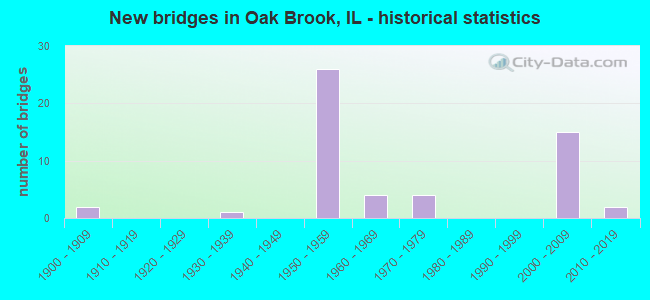
- New bridges - historical statistics
- 21900-1909
- 11930-1939
- 261950-1959
- 41960-1969
- 41970-1979
- 152000-2009
- 22010-2019

- Reconstructed bridges - Historical Statistics
- 11960-1969
- 11970-1979
- 31980-1989
- 01990-1999
- 22000-2009


- Bridge Condition - Deck
- 3.4%Very good
- 51.7%Good
- 34.5%Satisfactory
- 3.4%Fair
- 6.9%Poor

- Bridge Condition - Superstructure
- 17.2%Very good
- 34.5%Good
- 37.9%Satisfactory
- 10.3%Fair

- Bridge Condition - Substructure
- 10.3%Very good
- 48.3%Good
- 37.9%Satisfactory
- 3.4%Fair

- Bridge Condition - Channel
- 20.0%Very good
- 6.7%Good
- 53.3%Satisfactory
- 20.0%Fair

- Bridge Condition - Culverts
- 25.0%Very good
- 25.0%Good
- 50.0%Fair
Find on map >> Show street view
Structure Number: 160867, Location: 1 M N US 34 (Lat: 41.833153, Lng: -87.918658), Route carried "on" structure: Other road , Year Built: 1958, Year Reconstructed: 1992, Status: Open, Structure Length: 8.85m (29.04ft), Average Daily Traffic: 18,500 (year 2018), Truck Traffic: 3%, Average Future Daily Traffic: 17,407 (year 2032), Design Load: HS 20, Features Intersected: I-294 TRI STATE TOLL, Facility Carried by Structure: 31ST ST
Minimum Vertical Clearance: 30+ m (98+ ft), Kilometerpoint: 0.016, Lanes on structure: 4, Lanes under structure: 6, Base Highway Network: Yes, Owner: State Highway Agency, Approaching Roadway Width: 20.7m (67.9ft), Skew: 30 degrees, Material/Design: Prestressed concrete continuous, Design/Construction: Stringer/Multi-beam, Number Of Spans In Main Unit: 2, Number Of Approach Spans: 2, Length of Maximum Span: 36.1m (118.4ft), Curb-To-Curb Width: 18.3m (60.0ft), Out-to-Out Width: 21.7m (71.2ft)
Condition: Deck: Good, Superstructure: Fair, Substructure: Good, Operating Rating: 64.5 metric tons, Method Used To Determine Operating Rating: Load Factor (LF) rating reported by rating factor (RF) method using MS18 loading, Inventory Rating: 38.9 metric tons, Method Used To Determine Inventory Rating: Load Factor (LF) rating reported by rating factor (RF) method using MS18 loading, Structural Evaluation: Somewhat better than minimum adequacy, Deck Geometry: Somewhat better than minimum adequacy, Underclear: Meets minimum limits, Approach Roadway Alignment: Equal to present desirable criteria, Designated Inspection Frequency: Every 24 months, Inspection Date: March 2021, Deck Structure Type: Concrete Cast-file-Place, Wearing Surface/Protective System: Wearing Surface: Epoxy Overlay, Deck Protection: Epoxy Coated Reinforcing
Find on map >> Show street view
Structure Number: 162854, Location: 2 M N OF US 34 (Lat: 41.847658, Lng: -87.919250), Route carried "on" structure: Other road , Year Built: 2005, Status: Open, Structure Length: 8.52m (27.95ft), Average Daily Traffic: 20,300 (year 2021), Truck Traffic: 2%, Average Future Daily Traffic: 29,973 (year 2032), Design Load: HS 20, Features Intersected: I-294 TRI STATE, Facility Carried by Structure: CERMAK RD (22ND ST
Minimum Vertical Clearance: 30+ m (98+ ft), Kilometerpoint: 0.048, Lanes on structure: 5, Lanes under structure: 12, Base Highway Network: Yes, Owner: State Highway Agency, Approaching Roadway Width: 21.9m (71.9ft), Material/Design: Steel continuous, Design/Construction: Stringer/Multi-beam, Number Of Spans In Main Unit: 2, Length of Maximum Span: 44.7m (146.7ft), Curb-To-Curb Width: 21.9m (71.9ft), Out-to-Out Width: 25.0m (82.0ft)
Condition: Deck: Good, Superstructure: Good, Substructure: Good, Operating Rating: 63.5 metric tons, Method Used To Determine Operating Rating: Load Factor (LF) rating reported by rating factor (RF) method using MS18 loading, Inventory Rating: 37.9 metric tons, Method Used To Determine Inventory Rating: Load Factor (LF) rating reported by rating factor (RF) method using MS18 loading, Structural Evaluation: Better than present minimum criteria, Deck Geometry: Somewhat better than minimum adequacy, Underclear: High priority of corrective action, Approach Roadway Alignment: Equal to present desirable criteria, Designated Inspection Frequency: Every 24 months, Inspection Date: May 2019, Deck Structure Type: Concrete Cast-file-Place, Wearing Surface/Protective System: Wearing Surface: Epoxy Overlay, Deck Protection: Epoxy Coated Reinforcing
Find on map >> Show street view
Structure Number: 169806, Location: 0.5 M S ILL 5 P20 (Lat: 41.862297, Lng: -87.918525), Route carried "on" structure: Interstate 294, Year Built: 1957, Status: Open, Structure Length: 2.77m (9.09ft), Average Daily Traffic: 57,700 (year 2020), Truck Traffic: 22%, Average Future Daily Traffic: 62,933 (year 2032), Features Intersected: ROOSEVELT R (ILL 38)
Minimum Vertical Clearance: 30+ m (98+ ft), Kilometerpoint: 36.016, Lanes on structure: 3, Lanes under structure: 5, Base Highway Network: Yes, Toll: On toll road, Owner: State Toll Authority, Approaching Roadway Width: 17.7m (58.1ft), Skew: 1 degrees, Material/Design: Prestressed concrete, Design/Construction: Stringer/Multi-beam, Number Of Spans In Main Unit: 1, Length of Maximum Span: 25.9m (85.0ft), Curb-To-Curb Width: 16.5m (54.1ft), Out-to-Out Width: 21.0m (68.9ft)
Condition: Deck: Satisfactory, Superstructure: Satisfactory, Substructure: Satisfactory, Operating Rating: 96.9 metric tons, Method Used To Determine Operating Rating: Load Factor (LF) rating reported by rating factor (RF) method using MS18 loading, Inventory Rating: 58.0 metric tons, Method Used To Determine Inventory Rating: Load Factor (LF) rating reported by rating factor (RF) method using MS18 loading, Structural Evaluation: Equal to present minimum criteria, Deck Geometry: Equal to present minimum criteria, Underclear: Meets minimum limits, Approach Roadway Alignment: Equal to present desirable criteria, Designated Inspection Frequency: Every 24 months, Inspection Date: May 2019, Deck Structure Type: Concrete Cast-file-Place, Wearing Surface/Protective System: Wearing Surface: Bituminous, Membrane: Built-up
Find on map >> Show street view
Structure Number: 169807, Location: 0.5 M S ILL 5 P20 (Lat: 41.862181, Lng: -87.918558), Route carried "on" structure: Interstate 294, Year Built: 1957, Status: Open, Structure Length: 2.77m (9.09ft), Average Daily Traffic: 61,200 (year 2020), Truck Traffic: 28%, Average Future Daily Traffic: 68,032 (year 2032), Features Intersected: ROOSEVELT R (ILL 38)
Minimum Vertical Clearance: 30+ m (98+ ft), Kilometerpoint: 36.032, Lanes on structure: 3, Lanes under structure: 5, Base Highway Network: Yes, Toll: On toll road, Owner: State Toll Authority, Approaching Roadway Width: 17.7m (58.1ft), Skew: 1 degrees, Material/Design: Prestressed concrete, Design/Construction: Stringer/Multi-beam, Number Of Spans In Main Unit: 1, Length of Maximum Span: 25.9m (85.0ft), Curb-To-Curb Width: 16.5m (54.1ft), Out-to-Out Width: 21.0m (68.9ft)
Condition: Deck: Satisfactory, Superstructure: Satisfactory, Substructure: Fair, Operating Rating: 85.2 metric tons, Method Used To Determine Operating Rating: Load Factor (LF) rating reported by rating factor (RF) method using MS18 loading, Inventory Rating: 51.2 metric tons, Method Used To Determine Inventory Rating: Load Factor (LF) rating reported by rating factor (RF) method using MS18 loading, Structural Evaluation: Somewhat better than minimum adequacy, Deck Geometry: Equal to present minimum criteria, Underclear: Meets minimum limits, Approach Roadway Alignment: Equal to present desirable criteria, Designated Inspection Frequency: Every 24 months, Inspection Date: May 2019, Deck Structure Type: Concrete Cast-file-Place, Wearing Surface/Protective System: Wearing Surface: Bituminous, Membrane: Built-up
Find on map >> Show street view
Structure Number: 169809, Location: 1 M N US 34 P20 (Lat: 41.828894, Lng: -87.918464), Route carried "on" structure: Interstate 294, Year Built: 1958, Status: Open, Structure Length: 4.27m (14.01ft), Average Daily Traffic: 76,800 (year 2020), Truck Traffic: 22%, Average Future Daily Traffic: 77,250 (year 2032), Features Intersected: SALT CR
Minimum Vertical Clearance: 30+ m (98+ ft), Kilometerpoint: 39.830, Lanes on structure: 3, Base Highway Network: Yes, Toll: On toll road, Owner: State Toll Authority, Approaching Roadway Width: 15.8m (51.8ft), Material/Design: Prestressed concrete, Design/Construction: Stringer/Multi-beam, Number Of Spans In Main Unit: 3, Length of Maximum Span: 13.7m (44.9ft), Curb-To-Curb Width: 14.2m (46.6ft), Out-to-Out Width: 18.6m (61.0ft)
Condition: Deck: Satisfactory, Superstructure: Fair, Substructure: Satisfactory, Channel: Fair, Operating Rating: 63.5 metric tons, Method Used To Determine Operating Rating: Load Factor (LF) rating reported by rating factor (RF) method using MS18 loading, Inventory Rating: 37.9 metric tons, Method Used To Determine Inventory Rating: Load Factor (LF) rating reported by rating factor (RF) method using MS18 loading, Structural Evaluation: Somewhat better than minimum adequacy, Deck Geometry: Meets minimum limits, Waterway Adequacy: Superior to present desirable criteria, Approach Roadway Alignment: Equal to present desirable criteria, Designated Inspection Frequency: Every 24 months, Underwater Inspection Frequency: Every 60 months, Inspection Date: April 2021, Underwater Inspection Date: April 2018, Deck Structure Type: Concrete Cast-file-Place, Wearing Surface/Protective System: Wearing Surface: Bituminous, Membrane: Built-up
Find on map >> Show street view
Structure Number: 16981, Location: 1 M N US 34 P20 (Lat: 41.828750, Lng: -87.918456), Route carried "on" structure: Interstate 294, Year Built: 1958, Status: Open, Structure Length: 4.27m (14.01ft), Average Daily Traffic: 76,800 (year 2020), Truck Traffic: 22%, Average Future Daily Traffic: 77,250 (year 2032), Features Intersected: SALT CR
Minimum Vertical Clearance: 30+ m (98+ ft), Kilometerpoint: 39.846, Lanes on structure: 3, Base Highway Network: Yes, Toll: On toll road, Owner: State Toll Authority, Approaching Roadway Width: 15.8m (51.8ft), Material/Design: Prestressed concrete, Design/Construction: Stringer/Multi-beam, Number Of Spans In Main Unit: 4, Length of Maximum Span: 13.7m (44.9ft), Curb-To-Curb Width: 14.2m (46.6ft), Out-to-Out Width: 18.6m (61.0ft)
Condition: Deck: Satisfactory, Superstructure: Satisfactory, Substructure: Satisfactory, Channel: Fair, Operating Rating: 63.5 metric tons, Method Used To Determine Operating Rating: Load Factor (LF) rating reported by rating factor (RF) method using MS18 loading, Inventory Rating: 37.9 metric tons, Method Used To Determine Inventory Rating: Load Factor (LF) rating reported by rating factor (RF) method using MS18 loading, Structural Evaluation: Equal to present minimum criteria, Deck Geometry: Meets minimum limits, Waterway Adequacy: Superior to present desirable criteria, Approach Roadway Alignment: Equal to present desirable criteria, Designated Inspection Frequency: Every 24 months, Inspection Date: April 2021, Deck Structure Type: Concrete Cast-file-Place, Wearing Surface/Protective System: Wearing Surface: Bituminous, Membrane: Built-up
Find on map >> Show street view
Structure Number: 169938, Location: 0.2M S 22ND P20 (Lat: 41.844297, Lng: -87.919481), Route carried "on" structure: Other road , Year Built: 1958, Status: Open, Structure Length: 15.09m (49.51ft), Average Daily Traffic: 16,000 (year 2020), Average Future Daily Traffic: 11,586 (year 2032), Design Load: HS 20, Features Intersected: I-294, Facility Carried by Structure: I-294 NB TO I-88 W
Minimum Vertical Clearance: 30+ m (98+ ft), Kilometerpoint: 0.483, Lanes on structure: 2, Lanes under structure: 6, Base Highway Network: Yes (Inventory Route: 10088041, Subroute: 20), Toll: On toll road, Owner: State Toll Authority, Approaching Roadway Width: 12.2m (40.0ft), Skew: 6 degrees, Material/Design: Steel, Design/Construction: Stringer/Multi-beam, Number Of Spans In Main Unit: 4, Length of Maximum Span: 44.5m (146.0ft), Curb-To-Curb Width: 10.5m (34.4ft), Out-to-Out Width: 11.6m (38.1ft)
Condition: Deck: Satisfactory, Superstructure: Satisfactory, Substructure: Satisfactory, Operating Rating: 59.6 metric tons, Method Used To Determine Operating Rating: Load Factor (LF) rating reported by rating factor (RF) method using MS18 loading, Inventory Rating: 35.6 metric tons, Method Used To Determine Inventory Rating: Load Factor (LF) rating reported by rating factor (RF) method using MS18 loading, Structural Evaluation: Equal to present minimum criteria, Deck Geometry: Meets minimum limits, Underclear: Meets minimum limits, Approach Roadway Alignment: Better than present minimum criteria, Designated Inspection Frequency: Every 24 months, Inspection Date: May 2020, Deck Structure Type: Concrete Cast-file-Place, Wearing Surface/Protective System: Wearing Surface: Bituminous, Membrane: Built-up
Find on map >> Show street view
Structure Number: 220047, Location: 2 M W OF YORK RD (Lat: 41.845178, Lng: -87.957769), Route carried "on" structure: State highway 83, Year Built: 1958, Year Reconstructed: 1986, Status: Open, Structure Length: 7.25m (23.79ft), Average Daily Traffic: 34,300 (year 2021), Truck Traffic: 2%, Average Future Daily Traffic: 67,843 (year 2032), Design Load: HS 20, Features Intersected: I- 88 EW TOLL
Minimum Vertical Clearance: 30+ m (98+ ft), Kilometerpoint: 67.929, Lanes on structure: 6, Lanes under structure: 7, Base Highway Network: Yes, Owner: State Highway Agency, Approaching Roadway Width: 28.0m (91.9ft), Skew: 30 degrees, Material/Design: Prestressed concrete, Design/Construction: Stringer/Multi-beam, Number Of Spans In Main Unit: 4, Length of Maximum Span: 24.4m (80.1ft), Curb-To-Curb Width: 33.1m (108.6ft), Out-to-Out Width: 41.9m (137.5ft)
Condition: Deck: Satisfactory, Superstructure: Satisfactory, Substructure: Satisfactory, Operating Rating: 61.6 metric tons, Method Used To Determine Operating Rating: Load Factor (LF) rating reported by rating factor (RF) method using MS18 loading, Inventory Rating: 36.9 metric tons, Method Used To Determine Inventory Rating: Load Factor (LF) rating reported by rating factor (RF) method using MS18 loading, Structural Evaluation: Equal to present minimum criteria, Deck Geometry: Superior to present desirable criteria, Underclear: High priority of corrective action, Approach Roadway Alignment: Better than present minimum criteria, Designated Inspection Frequency: Every 24 months, Inspection Date: September 2020, Deck Structure Type: Concrete Cast-file-Place, Wearing Surface/Protective System: Deck Protection: Epoxy Coated Reinforcing
Find on map >> Show street view
Structure Number: 220058, Location: 2.4 M W OF US 45 (Lat: 41.861747, Lng: -87.922706), Route carried "on" structure: State highway 38, Year Built: 1952, Year Reconstructed: 1992, Status: Open, Structure Length: 12.18m (39.96ft), Average Daily Traffic: 50,300 (year 2021), Truck Traffic: 8%, Average Future Daily Traffic: 29,020 (year 2032), Design Load: HS 20, Features Intersected: IL 38 EB RAMP
Minimum Vertical Clearance: 30+ m (98+ ft), Kilometerpoint: 140.154, Lanes on structure: 2, Lanes under structure: 2, Base Highway Network: Yes, Owner: State Highway Agency, Approaching Roadway Width: 12.2m (40.0ft), Skew: 30 degrees, Material/Design: Steel continuous, Design/Construction: Stringer/Multi-beam, Number Of Spans In Main Unit: 3, Length of Maximum Span: 55.8m (183.1ft), Curb-To-Curb Width: 9.1m (29.9ft), Out-to-Out Width: 11.4m (37.4ft)
Condition: Deck: Good, Superstructure: Satisfactory, Substructure: Satisfactory, Operating Rating: 67.4 metric tons, Method Used To Determine Operating Rating: Load Factor (LF) rating reported by rating factor (RF) method using MS18 loading, Inventory Rating: 39.9 metric tons, Method Used To Determine Inventory Rating: Load Factor (LF) rating reported by rating factor (RF) method using MS18 loading, Structural Evaluation: Equal to present minimum criteria, Deck Geometry: Meets minimum limits, Underclear: Meets minimum limits, Approach Roadway Alignment: Better than present minimum criteria, Length Of Structure Improvement: 12.74m (41.80ft), Designated Inspection Frequency: Every 24 months, Inspection Date: July 2020, Bridge Improvement Cost: $1,860,000, Roadway Improvement Cost: $186,000, Total Project Cost: $2,790,000, Deck Structure Type: Concrete Cast-file-Place, Wearing Surface/Protective System: Deck Protection: Epoxy Coated Reinforcing
Find on map >> Show street view
Structure Number: 220084, Location: 1.7 M E OF IL 83 (Lat: 41.847158, Lng: -87.936719), Route carried "on" structure: Other road , Year Built: 1932, Year Reconstructed: 2008, Status: Open, Structure Length: 4.85m (15.91ft), Average Daily Traffic: 9,950 (year 2020), Truck Traffic: 8%, Average Future Daily Traffic: 23,394 (year 2032), Design Load: HS 20, Features Intersected: SALT CREEK, Facility Carried by Structure: 22ND ST (CERMAK RD
Minimum Vertical Clearance: 30+ m (98+ ft), Kilometerpoint: 3.862, Lanes on structure: 6, Base Highway Network: Yes, Owner: State Highway Agency, Approaching Roadway Width: 26.8m (87.9ft), Skew: 30 degrees, Material/Design: Prestressed concrete, Design/Construction: Box Beam or Girders - Multiple, Number Of Spans In Main Unit: 3, Length of Maximum Span: 16.2m (53.1ft), Curb or Sidewalk Widths: Left: 0.0m, Right: 2.7m (8.9ft), Curb-To-Curb Width: 24.4m (80.1ft), Out-to-Out Width: 30.9m (101.4ft)
Condition: Deck: Satisfactory, Superstructure: Satisfactory, Substructure: Satisfactory, Channel: Satisfactory, Operating Rating: 71.9 metric tons, Method Used To Determine Operating Rating: Load Factor (LF) rating reported by rating factor (RF) method using MS18 loading, Inventory Rating: 43.1 metric tons, Method Used To Determine Inventory Rating: Load Factor (LF) rating reported by rating factor (RF) method using MS18 loading, Structural Evaluation: Equal to present minimum criteria, Deck Geometry: Somewhat better than minimum adequacy, Waterway Adequacy: Equal to present desirable criteria, Approach Roadway Alignment: Equal to present desirable criteria, Designated Inspection Frequency: Every 24 months, Inspection Date: August 2020, Deck Structure Type: Concrete Cast-file-Place, Wearing Surface/Protective System: Wearing Surface: Integral Concrete, Deck Protection: Epoxy Coated Reinforcing
Find on map >> Show street view
Structure Number: 22014, Location: 1 M S I-88 EW TOLL (Lat: 41.832200, Lng: -87.955319), Route carried "on" structure: Other road , Year Built: 1974, Status: Open, Structure Length: 6.57m (21.56ft), Average Daily Traffic: 14,200 (year 2020), Truck Traffic: 5%, Average Future Daily Traffic: 21,389 (year 2032), Design Load: HS 20, Features Intersected: IL 83, Facility Carried by Structure: 31ST ST
Minimum Vertical Clearance: 30+ m (98+ ft), Kilometerpoint: 4.812, Lanes on structure: 6, Lanes under structure: 6, Base Highway Network: Yes, Owner: State Highway Agency, Approaching Roadway Width: 24.1m (79.1ft), Skew: 32 degrees, Material/Design: Steel continuous, Design/Construction: Stringer/Multi-beam, Number Of Spans In Main Unit: 2, Number Of Approach Spans: 2, Length of Maximum Span: 25.3m (83.0ft), Curb-To-Curb Width: 24.1m (79.1ft), Out-to-Out Width: 26.2m (86.0ft)
Condition: Deck: Satisfactory, Superstructure: Satisfactory, Substructure: Good, Operating Rating: 78.4 metric tons, Method Used To Determine Operating Rating: Load Factor (LF) rating reported by rating factor (RF) method using MS18 loading, Inventory Rating: 42.4 metric tons, Method Used To Determine Inventory Rating: Load Factor (LF) rating reported by rating factor (RF) method using MS18 loading, Structural Evaluation: Equal to present minimum criteria, Deck Geometry: Somewhat better than minimum adequacy, Underclear: Equal to present minimum criteria, Approach Roadway Alignment: Equal to present desirable criteria, Designated Inspection Frequency: Every 24 months, Inspection Date: July 2021, Deck Structure Type: Concrete Cast-file-Place
Find on map >> Show street view
Structure Number: 220524, Location: 1 M E OF HIGHLAND (Lat: 41.841725, Lng: -87.993714), Route carried "on" structure: State highway 56, Year Built: 1974, Status: Open, Structure Length: 0.66m (2.17ft), Average Daily Traffic: 40,400 (year 2021), Truck Traffic: 2%, Average Future Daily Traffic: 31,000 (year 2042), Features Intersected: DITCH
Minimum Vertical Clearance: 30+ m (98+ ft), Kilometerpoint: 41.407, Lanes on structure: 7, Base Highway Network: Yes, Owner: State Highway Agency, Approaching Roadway Width: 30.5m (100.1ft), Skew: 3 degrees, Material/Design: Concrete, Design/Construction: Culvert, Number Of Spans In Main Unit: 2, Length of Maximum Span: 0.0m
Condition: Channel: Satisfactory, Culverts: Very good, Operating Rating: 42.1 metric tons, Method Used To Determine Operating Rating: Load and Resistance Factor Rating (LRFR) rating reported by rating factor(RF) method using HL-93 loadings, Inventory Rating: 32.4 metric tons, Method Used To Determine Inventory Rating: Load and Resistance Factor Rating (LRFR) rating reported by rating factor(RF) method using HL-93 loadings, Structural Evaluation: Equal to present desirable criteria, Waterway Adequacy: Equal to present desirable criteria, Approach Roadway Alignment: Equal to present desirable criteria, Designated Inspection Frequency: Every 48 months, Inspection Date: March 2020
Find on map >> Show street view
Structure Number: 222, Location: 0.36 M S OF I-88 (Lat: 41.838317, Lng: -87.957692), Route carried "on" structure: State highway 83, Year Built: 1952, Year Reconstructed: 1975, Status: Open, Structure Length: 0.79m (2.59ft), Average Daily Traffic: 34,300 (year 2021), Truck Traffic: 2%, Average Future Daily Traffic: 67,843 (year 2032), Design Load: H 20, Features Intersected: DRAINAGE DITCH
Minimum Vertical Clearance: 30+ m (98+ ft), Kilometerpoint: 67.204, Lanes on structure: 6, Base Highway Network: Yes, Owner: State Highway Agency, Approaching Roadway Width: 35.1m (115.2ft), Skew: 32 degrees, Material/Design: Concrete continuous, Design/Construction: Culvert, Number Of Spans In Main Unit: 2, Length of Maximum Span: 3.7m (12.1ft)
Condition: Channel: Satisfactory, Culverts: Fair, Operating Rating: 79.1 metric tons, Method Used To Determine Operating Rating: Load Factor (LF) rating reported by rating factor (RF) method using MS18 loading, Inventory Rating: 47.3 metric tons, Method Used To Determine Inventory Rating: Load Factor (LF) rating reported by rating factor (RF) method using MS18 loading, Structural Evaluation: Somewhat better than minimum adequacy, Waterway Adequacy: Equal to present minimum criteria, Approach Roadway Alignment: Better than present minimum criteria, Designated Inspection Frequency: Every 24 months, Inspection Date: January 2022
Find on map >> Show street view
Structure Number: 22305, Location: 0.6MI E OF IL-83 (Lat: 41.832472, Lng: -87.945097), Route carried "on" structure: Other road , Year Built: 2002, Status: Open, Structure Length: 4.38m (14.37ft), Average Daily Traffic: 11,800 (year 2020), Truck Traffic: 3%, Average Future Daily Traffic: 12,588 (year 2032), Design Load: HS 20, Features Intersected: SALT CREEK, Facility Carried by Structure: 31ST STREET
Minimum Vertical Clearance: 30+ m (98+ ft), Kilometerpoint: 5.681, Lanes on structure: 4, Base Highway Network: Yes, Owner: County Highway Agency, Approaching Roadway Width: 15.9m (52.2ft), Skew: 32 degrees, Material/Design: Prestressed concrete, Design/Construction: Box Beam or Girders - Multiple, Number Of Spans In Main Unit: 3, Length of Maximum Span: 16.5m (54.1ft), Curb or Sidewalk Widths: Left: 3.0m (9.8ft), Right: 0.0m, Curb-To-Curb Width: 15.9m (52.2ft), Out-to-Out Width: 25.1m (82.3ft)
Condition: Deck: Satisfactory, Superstructure: Good, Substructure: Very good, Channel: Satisfactory, Operating Rating: 78.1 metric tons, Method Used To Determine Operating Rating: Load Factor (LF) rating reported by rating factor (RF) method using MS18 loading, Inventory Rating: 46.7 metric tons, Method Used To Determine Inventory Rating: Load Factor (LF) rating reported by rating factor (RF) method using MS18 loading, Structural Evaluation: Better than present minimum criteria, Deck Geometry: Meets minimum limits, Waterway Adequacy: Equal to present minimum criteria, Approach Roadway Alignment: Equal to present desirable criteria, Designated Inspection Frequency: Every 48 months, Inspection Date: September 2018, Deck Structure Type: Concrete Precast Panels, Wearing Surface/Protective System: Deck Protection: Epoxy Coated Reinforcing
Find on map >> Show street view
Structure Number: 22311, Location: 0.5 MI S I-88 (Lat: 41.838039, Lng: -87.972103), Route carried "on" structure: Other road , Year Built: 2001, Status: Open, Structure Length: 0.84m (2.76ft), Average Daily Traffic: 7,300 (year 2020), Truck Traffic: 6%, Average Future Daily Traffic: 16,153 (year 2032), Design Load: HS 20, Features Intersected: GINGER CREEK, Facility Carried by Structure: MIDWEST ROAD
Minimum Vertical Clearance: 30+ m (98+ ft), Kilometerpoint: 4.104, Lanes on structure: 4, Base Highway Network: Yes, Owner: County Highway Agency, Approaching Roadway Width: 14.7m (48.2ft), Skew: 23 degrees, Material/Design: Concrete, Design/Construction: Culvert, Number Of Spans In Main Unit: 2, Length of Maximum Span: 3.8m (12.5ft), Curb or Sidewalk Widths: Left: 0.0m, Right: 1.8m (5.9ft)
Condition: Channel: Very good, Culverts: Good, Operating Rating: 44.1 metric tons, Method Used To Determine Operating Rating: Assigned rating based on Load Factor Design (LFD) reported by rating factor (RF) using MS18 loading, Inventory Rating: 32.4 metric tons, Method Used To Determine Inventory Rating: Assigned rating based on Load Factor Design (LFD) reported by rating factor (RF) using MS18 loading, Structural Evaluation: Better than present minimum criteria, Waterway Adequacy: Equal to present desirable criteria, Approach Roadway Alignment: Equal to present desirable criteria, Designated Inspection Frequency: Every 48 months, Inspection Date: October 2019
Find on map >> Show street view
Structure Number: 22685, Location: 1500 FT E OF SUMMIT (Lat: 41.839689, Lng: -87.966083), Route carried "on" structure: City street , Year Built: 1968, Status: Open, Structure Length: 1.92m (6.30ft), Average Daily Traffic: 275 (year 2020), Truck Traffic: 12%, Average Future Daily Traffic: 567 (year 2032), Design Load: HS 20, Features Intersected: GINGER CREEK, Facility Carried by Structure: REGENT DRIVE
Minimum Vertical Clearance: 30+ m (98+ ft), Kilometerpoint: 0.483, Lanes on structure: 2, Owner: City or Municipal Highway Agency, Approaching Roadway Width: 11.0m (36.1ft), Material/Design: Concrete continuous, Design/Construction: Slab, Number Of Spans In Main Unit: 3, Length of Maximum Span: 7.0m (23.0ft), Curb or Sidewalk Widths: Left: 1.2m (3.9ft), Right: 1.2m (3.9ft), Curb-To-Curb Width: 11.0m (36.1ft), Out-to-Out Width: 14.0m (45.9ft)
Condition: Deck: Fair, Superstructure: Fair, Substructure: Good, Channel: Good, Operating Rating: 62.2 metric tons, Method Used To Determine Operating Rating: Load Factor (LF) rating reported by rating factor (RF) method using MS18 loading, Inventory Rating: 37.3 metric tons, Method Used To Determine Inventory Rating: Load Factor (LF) rating reported by rating factor (RF) method using MS18 loading, Structural Evaluation: Somewhat better than minimum adequacy, Deck Geometry: Equal to present desirable criteria, Waterway Adequacy: Equal to present desirable criteria, Approach Roadway Alignment: Equal to present desirable criteria, Designated Inspection Frequency: Every 24 months, Inspection Date: May 2021, Deck Structure Type: Concrete Cast-file-Place, Wearing Surface/Protective System: Wearing Surface: Bituminous
Find on map >> Show street view
Structure Number: 226851, Location: 0.25 MI E MEYERS RD (Lat: 41.835653, Lng: -87.986092), Route carried "on" structure: City street , Year Built: 1960, Year Reconstructed: 2007, Status: Open, Structure Length: 0.82m (2.69ft), Average Daily Traffic: 225 (year 2020), Truck Traffic: 12%, Average Future Daily Traffic: 344 (year 2032), Design Load: HS 20, Features Intersected: GINGER CREEK, Facility Carried by Structure: BAYBROOK LANE
Minimum Vertical Clearance: 30+ m (98+ ft), Kilometerpoint: 0.531, Lanes on structure: 2, Owner: City or Municipal Highway Agency, Approaching Roadway Width: 6.7m (22.0ft), Material/Design: Prestressed concrete, Design/Construction: Box Beam or Girders - Multiple, Number Of Spans In Main Unit: 1, Length of Maximum Span: 7.8m (25.6ft), Curb or Sidewalk Widths: Left: 1.9m (6.2ft), Right: 0.0m, Curb-To-Curb Width: 6.7m (22.0ft), Out-to-Out Width: 9.2m (30.2ft)
Condition: Deck: Good, Superstructure: Good, Substructure: Good, Channel: Very good, Operating Rating: 61.9 metric tons, Method Used To Determine Operating Rating: Load Factor (LF) rating reported by rating factor (RF) method using MS18 loading, Inventory Rating: 36.9 metric tons, Method Used To Determine Inventory Rating: Load Factor (LF) rating reported by rating factor (RF) method using MS18 loading, Structural Evaluation: Better than present minimum criteria, Deck Geometry: Meets minimum limits, Waterway Adequacy: Equal to present desirable criteria, Approach Roadway Alignment: Equal to present desirable criteria, Designated Inspection Frequency: Every 48 months, Inspection Date: May 2019, Deck Structure Type: Concrete Precast Panels, Wearing Surface/Protective System: Wearing Surface: Bituminous, Membrane: Built-up
Find on map >> Show street view
Structure Number: 226853, Location: .25 MI N 22 ND ST. (Lat: 41.846044, Lng: -87.925631), Route carried "on" structure: City street , Year Built: 1960, Status: Open, Structure Length: 6.77m (22.21ft), Average Daily Traffic: 475 (year 2020), Truck Traffic: 5%, Average Future Daily Traffic: 567 (year 2032), Design Load: HS 20, Features Intersected: EAST WEST TOLLWAY, Facility Carried by Structure: WINDSOR DRIVE
Minimum Vertical Clearance: 30+ m (98+ ft), Kilometerpoint: 0.032, Lanes on structure: 2, Lanes under structure: 4, Owner: State Toll Authority, Approaching Roadway Width: 7.3m (24.0ft), Material/Design: Prestressed concrete, Design/Construction: Stringer/Multi-beam, Number Of Spans In Main Unit: 4, Length of Maximum Span: 20.1m (65.9ft), Curb or Sidewalk Widths: Left: 1.5m (4.9ft), Right: 1.5m (4.9ft), Curb-To-Curb Width: 9.1m (29.9ft), Out-to-Out Width: 12.6m (41.3ft)
Condition: Deck: Poor, Superstructure: Satisfactory, Substructure: Satisfactory, Operating Rating: 90.7 metric tons, Method Used To Determine Operating Rating: Load Factor (LF) rating reported by rating factor (RF) method using MS18 loading, Inventory Rating: 54.4 metric tons, Method Used To Determine Inventory Rating: Load Factor (LF) rating reported by rating factor (RF) method using MS18 loading, Structural Evaluation: Equal to present minimum criteria, Deck Geometry: Equal to present minimum criteria, Underclear: Meets minimum limits, Approach Roadway Alignment: Equal to present minimum criteria, Designated Inspection Frequency: Every 24 months, Inspection Date: July 2020, Deck Structure Type: Concrete Cast-file-Place
Find on map >> Show street view
Structure Number: 226854, Location: .4 MI N 22 ND ST (Lat: 41.852853, Lng: -87.935689), Route carried "on" structure: Other road , Year Built: 1958, Status: Open, Structure Length: 4.39m (14.40ft), Average Daily Traffic: 1,150 (year 2020), Truck Traffic: 3%, Average Future Daily Traffic: 2,507 (year 2032), Design Load: HS 20, Features Intersected: SALT CREEK, Facility Carried by Structure: HARGER RD
Minimum Vertical Clearance: 30+ m (98+ ft), Kilometerpoint: 1.078, Lanes on structure: 2, Owner: State Toll Authority, Approaching Roadway Width: 7.3m (24.0ft), Skew: 1 degrees, Material/Design: Prestressed concrete, Design/Construction: Stringer/Multi-beam, Number Of Spans In Main Unit: 2, Length of Maximum Span: 21.3m (69.9ft), Curb or Sidewalk Widths: Left: 0.6m (2.0ft), Right: 0.6m (2.0ft), Curb-To-Curb Width: 7.3m (24.0ft), Out-to-Out Width: 9.4m (30.8ft)
Condition: Deck: Good, Superstructure: Satisfactory, Substructure: Satisfactory, Channel: Satisfactory, Operating Rating: 96.9 metric tons, Method Used To Determine Operating Rating: Load Factor (LF) rating reported by rating factor (RF) method using MS18 loading, Inventory Rating: 58.3 metric tons, Method Used To Determine Inventory Rating: Load Factor (LF) rating reported by rating factor (RF) method using MS18 loading, Structural Evaluation: Equal to present minimum criteria, Deck Geometry: Meets minimum limits, Waterway Adequacy: Superior to present desirable criteria, Approach Roadway Alignment: Equal to present minimum criteria, Length Of Structure Improvement: 5.27m (17.29ft), Designated Inspection Frequency: Every 24 months, Underwater Inspection Frequency: Every 60 months, Inspection Date: May 2019, Underwater Inspection Date: April 2018, Bridge Improvement Cost: $393,000, Roadway Improvement Cost: $39,000, Total Project Cost: $590,000
Find on map >> Show street view
Structure Number: 226855, Location: .4 MI N 31ST STREET (Lat: 41.838531, Lng: -87.949083), Route carried "on" structure: Other road , Year Built: 1973, Status: Open, Structure Length: 0.67m (2.20ft), Average Daily Traffic: 4,700 (year 2020), Truck Traffic: 3%, Average Future Daily Traffic: 9,692 (year 2032), Features Intersected: GINGER CREEK, Facility Carried by Structure: JORIE BLVD
Minimum Vertical Clearance: 30+ m (98+ ft), Kilometerpoint: 1.674, Lanes on structure: 4, Owner: City or Municipal Highway Agency, Approaching Roadway Width: 21.3m (69.9ft), Skew: 32 degrees, Material/Design: Concrete, Design/Construction: Culvert, Number Of Spans In Main Unit: 2, Length of Maximum Span: 2.7m (8.9ft), Curb or Sidewalk Widths: Left: 1.5m (4.9ft), Right: 1.8m (5.9ft), Curb-To-Curb Width: 21.3m (69.9ft), Out-to-Out Width: 25.3m (83.0ft)
Condition: Channel: Fair, Culverts: Fair, Operating Rating: 55.1 metric tons, Method Used To Determine Operating Rating: Allowable Stress (AS) rating reported by rating factor (RF) method using MS18 loading, Inventory Rating: 33.0 metric tons, Method Used To Determine Inventory Rating: Allowable Stress (AS) rating reported by rating factor (RF) method using MS18 loading, Structural Evaluation: Somewhat better than minimum adequacy, Deck Geometry: Superior to present desirable criteria, Waterway Adequacy: Better than present minimum criteria, Approach Roadway Alignment: Equal to present desirable criteria, Designated Inspection Frequency: Every 24 months, Inspection Date: January 2021, Wearing Surface/Protective System: Wearing Surface: Bituminous
Find on map >> Show street view
Structure Number: 229814, Location: 1.7 Mi NE of ILL. 83 (Lat: 41.856561, Lng: -87.929764), Route carried "on" structure: Other road , Year Built: 2018, Status: Open, Structure Length: 12.77m (41.90ft), Average Daily Traffic: 9,600 (year 2020), Truck Traffic: 5%, Average Future Daily Traffic: 15,930 (year 2032), Design Load: HS 25 or greater, Features Intersected: I-88, Facility Carried by Structure: York Road
Minimum Vertical Clearance: 30+ m (98+ ft), Kilometerpoint: 11.796, Lanes on structure: 4, Lanes under structure: 7, Base Highway Network: Yes, Owner: City or Municipal Highway Agency, Approaching Roadway Width: 19.5m (64.0ft), Skew: 5 degrees, Material/Design: Prestressed concrete continuous, Design/Construction: Stringer/Multi-beam, Number Of Spans In Main Unit: 2, Length of Maximum Span: 61.9m (203.1ft), Curb-To-Curb Width: 19.5m (64.0ft), Out-to-Out Width: 20.5m (67.3ft)
Condition: Deck: Very good, Superstructure: Very good, Substructure: Very good, Operating Rating: 97.2 metric tons, Method Used To Determine Operating Rating: Load Factor (LF) rating reported by rating factor (RF) method using MS18 loading, Inventory Rating: 59.6 metric tons, Method Used To Determine Inventory Rating: Load Factor (LF) rating reported by rating factor (RF) method using MS18 loading, Structural Evaluation: Equal to present desirable criteria, Deck Geometry: Better than present minimum criteria, Approach Roadway Alignment: Equal to present desirable criteria, Designated Inspection Frequency: Every 24 months, Inspection Date: July 2020, Deck Structure Type: Concrete Cast-file-Place, Wearing Surface/Protective System: Deck Protection: Epoxy Coated Reinforcing
Find on map >> Show street view
Structure Number: 229901, Location: 0.2 MI E IL 83 (Lat: 41.847225, Lng: -87.943050), Route carried "on" structure: Other road , Year Built: 2009, Status: Open, Structure Length: 6.12m (20.08ft), Average Daily Traffic: 16,000 (year 2012), Average Future Daily Traffic: 20,275 (year 2032), Design Load: HS 20, Features Intersected: CERMACK RD, Facility Carried by Structure: I88WB CDRAMP EW TO
Minimum Vertical Clearance: 30+ m (98+ ft), Kilometerpoint: 1.464, Lanes on structure: 2, Lanes under structure: 6, Base Highway Network: Yes (Inventory Route: 10088071, Subroute: 60), Toll: On toll road, Owner: State Toll Authority, Approaching Roadway Width: 13.0m (42.7ft), Skew: 5 degrees, Material/Design: Steel, Design/Construction: Stringer/Multi-beam, Number Of Spans In Main Unit: 2, Number Of Approach Spans: 2, Length of Maximum Span: 29.8m (97.8ft), Curb-To-Curb Width: 13.0m (42.7ft), Out-to-Out Width: 14.0m (45.9ft)
Condition: Deck: Good, Superstructure: Good, Substructure: Good, Operating Rating: 92.7 metric tons, Method Used To Determine Operating Rating: Load Factor (LF) rating reported by rating factor (RF) method using MS18 loading, Inventory Rating: 55.7 metric tons, Method Used To Determine Inventory Rating: Load Factor (LF) rating reported by rating factor (RF) method using MS18 loading, Structural Evaluation: Better than present minimum criteria, Deck Geometry: Superior to present desirable criteria, Approach Roadway Alignment: Equal to present desirable criteria, Designated Inspection Frequency: Every 24 months, Inspection Date: July 2020, Deck Structure Type: Concrete Cast-file-Place, Wearing Surface/Protective System: Deck Protection: Epoxy Coated Reinforcing
Find on map >> Show street view
Structure Number: 229905, Location: 2M.E.OF IL-83 (Lat: 41.853331, Lng: -87.929608), Route carried "on" structure: Other road , Year Built: 1958, Status: Open, Structure Length: 7.28m (23.88ft), Average Daily Traffic: 9,600 (year 2020), Truck Traffic: 5%, Average Future Daily Traffic: 15,930 (year 2032), Design Load: HS 20, Features Intersected: I-88 E-W Toll Ramp, Facility Carried by Structure: YORK ROAD
Minimum Vertical Clearance: 30+ m (98+ ft), Kilometerpoint: 12.182, Lanes on structure: 4, Lanes under structure: 4, Base Highway Network: Yes, Owner: City or Municipal Highway Agency, Approaching Roadway Width: 17.7m (58.1ft), Skew: 32 degrees, Material/Design: Prestressed concrete, Design/Construction: Stringer/Multi-beam, Number Of Spans In Main Unit: 4, Length of Maximum Span: 21.6m (70.9ft), Curb-To-Curb Width: 17.7m (58.1ft), Out-to-Out Width: 19.5m (64.0ft)
Condition: Deck: Poor, Superstructure: Satisfactory, Substructure: Satisfactory, Operating Rating: 64.5 metric tons, Method Used To Determine Operating Rating: Load Factor (LF) rating reported by rating factor (RF) method using MS18 loading, Inventory Rating: 38.9 metric tons, Method Used To Determine Inventory Rating: Load Factor (LF) rating reported by rating factor (RF) method using MS18 loading, Structural Evaluation: Equal to present minimum criteria, Deck Geometry: Somewhat better than minimum adequacy, Underclear: Meets minimum limits, Approach Roadway Alignment: Equal to present minimum criteria, Designated Inspection Frequency: Every 24 months, Inspection Date: July 2020, Deck Structure Type: Concrete Cast-file-Place
Find on map >> Show street view
Structure Number: 229907, Location: 0.7 MI W IL 83 (Lat: 41.844492, Lng: -87.972300), Route carried "on" structure: Other road , Year Built: 1958, Year Reconstructed: 1974, Status: Open, Structure Length: 6.77m (22.21ft), Average Daily Traffic: 3,650 (year 2020), Truck Traffic: 6%, Average Future Daily Traffic: 16,153 (year 2032), Design Load: HS 20, Features Intersected: I-88 E-W TOLL RD., Facility Carried by Structure: MIDWEST RD
Minimum Vertical Clearance: 30+ m (98+ ft), Kilometerpoint: 3.380, Lanes on structure: 4, Lanes under structure: 4, Base Highway Network: Yes, Owner: County Highway Agency, Approaching Roadway Width: 9.8m (32.2ft), Skew: 3 degrees, Material/Design: Prestressed concrete, Design/Construction: Stringer/Multi-beam, Number Of Spans In Main Unit: 4, Length of Maximum Span: 20.1m (65.9ft), Curb or Sidewalk Widths: Left: 0.6m (2.0ft), Right: 0.6m (2.0ft), Curb-To-Curb Width: 15.2m (49.9ft), Out-to-Out Width: 17.1m (56.1ft)
Condition: Deck: Good, Superstructure: Good, Substructure: Good, Operating Rating: 81.3 metric tons, Method Used To Determine Operating Rating: Load Factor (LF) rating reported by rating factor (RF) method using MS18 loading, Inventory Rating: 48.9 metric tons, Method Used To Determine Inventory Rating: Load Factor (LF) rating reported by rating factor (RF) method using MS18 loading, Structural Evaluation: Better than present minimum criteria, Deck Geometry: High priority of corrective action, Underclear: Meets minimum limits, Approach Roadway Alignment: Equal to present desirable criteria, Length Of Structure Improvement: 8.11m (26.61ft), Designated Inspection Frequency: Every 24 months, Inspection Date: August 2019, Bridge Improvement Cost: $1,313,000, Roadway Improvement Cost: $131,000, Total Project Cost: $1,970,000, Deck Structure Type: Concrete Cast-file-Place, Wearing Surface/Protective System: Wearing Surface: Bituminous
Find on map >> Show street view
Structure Number: 229932, Location: 1.3M.E.IL-83 (Lat: 41.851842, Lng: -87.934992), Route carried "on" structure: Interstate 88, Year Built: 1958, Status: Open, Structure Length: 4.18m (13.71ft), Average Daily Traffic: 47,500 (year 2020), Truck Traffic: 15%, Average Future Daily Traffic: 61,827 (year 2032), Design Load: HS 20, Features Intersected: SALT CREEK
Minimum Vertical Clearance: 30+ m (98+ ft), Kilometerpoint: 222.614, Lanes on structure: 2, Base Highway Network: Yes, Toll: On toll road, Owner: State Toll Authority, Approaching Roadway Width: 15.8m (51.8ft), Material/Design: Prestressed concrete, Design/Construction: Stringer/Multi-beam, Number Of Spans In Main Unit: 2, Length of Maximum Span: 20.1m (65.9ft), Curb-To-Curb Width: 12.9m (42.3ft), Out-to-Out Width: 21.0m (68.9ft)
Condition: Deck: Good, Superstructure: Very good, Substructure: Good, Channel: Satisfactory, Operating Rating: 74.5 metric tons, Method Used To Determine Operating Rating: Load Factor (LF) rating reported by rating factor (RF) method using MS18 loading, Inventory Rating: 44.7 metric tons, Method Used To Determine Inventory Rating: Load Factor (LF) rating reported by rating factor (RF) method using MS18 loading, Structural Evaluation: Better than present minimum criteria, Deck Geometry: Superior to present desirable criteria, Waterway Adequacy: Superior to present desirable criteria, Approach Roadway Alignment: Equal to present desirable criteria, Designated Inspection Frequency: Every 24 months, Underwater Inspection Frequency: Every 60 months, Inspection Date: July 2020, Underwater Inspection Date: April 2018, Wearing Surface/Protective System: Wearing Surface: Bituminous, Membrane: Built-up
Find on map >> Show street view
Structure Number: 229933, Location: 1.3 M NE OF ILL 83 (Lat: 41.851931, Lng: -87.934847), Route carried "on" structure: Interstate 88, Year Built: 1958, Status: Open, Structure Length: 4.18m (13.71ft), Average Daily Traffic: 47,500 (year 2020), Truck Traffic: 15%, Average Future Daily Traffic: 61,827 (year 2032), Design Load: HS 20, Features Intersected: SALT CREEK
Minimum Vertical Clearance: 30+ m (98+ ft), Kilometerpoint: 222.631, Lanes on structure: 2, Base Highway Network: Yes, Toll: On toll road, Owner: State Toll Authority, Approaching Roadway Width: 12.2m (40.0ft), Material/Design: Prestressed concrete, Design/Construction: Stringer/Multi-beam, Number Of Spans In Main Unit: 2, Length of Maximum Span: 20.1m (65.9ft), Curb-To-Curb Width: 10.5m (34.4ft), Out-to-Out Width: 18.6m (61.0ft)
Condition: Deck: Good, Superstructure: Very good, Substructure: Good, Channel: Satisfactory, Operating Rating: 75.2 metric tons, Method Used To Determine Operating Rating: Load Factor (LF) rating reported by rating factor (RF) method using MS18 loading, Inventory Rating: 45.0 metric tons, Method Used To Determine Inventory Rating: Load Factor (LF) rating reported by rating factor (RF) method using MS18 loading, Structural Evaluation: Better than present minimum criteria, Deck Geometry: Meets minimum limits, Waterway Adequacy: Superior to present desirable criteria, Approach Roadway Alignment: Equal to present desirable criteria, Designated Inspection Frequency: Every 24 months, Underwater Inspection Frequency: Every 60 months, Inspection Date: July 2020, Underwater Inspection Date: April 2018, Wearing Surface/Protective System: Wearing Surface: Bituminous, Membrane: Built-up
Find on map >> Show street view
Structure Number: 229934, Location: 1.0 M.N.22ND.ST. (Lat: 41.861656, Lng: -87.925367), Route carried "on" structure: Interstate 88, Year Built: 1958, Status: Open, Structure Length: 10.06m (33.01ft), Average Daily Traffic: 47,500 (year 2020), Truck Traffic: 15%, Average Future Daily Traffic: 61,827 (year 2032), Design Load: HS 20, Features Intersected: ILL 38 (ROOSEVELT RD
Minimum Vertical Clearance: 30+ m (98+ ft), Kilometerpoint: 223.934, Lanes on structure: 3, Lanes under structure: 6, Base Highway Network: Yes, Toll: On toll road, Owner: State Toll Authority, Approaching Roadway Width: 12.2m (40.0ft), Skew: 3 degrees, Material/Design: Prestressed concrete, Design/Construction: Stringer/Multi-beam, Number Of Spans In Main Unit: 5, Length of Maximum Span: 25.3m (83.0ft), Curb-To-Curb Width: 11.0m (36.1ft), Out-to-Out Width: 18.6m (61.0ft)
Condition: Deck: Good, Superstructure: Good, Substructure: Satisfactory, Operating Rating: 75.5 metric tons, Method Used To Determine Operating Rating: Load Factor (LF) rating reported by rating factor (RF) method using MS18 loading, Inventory Rating: 45.4 metric tons, Method Used To Determine Inventory Rating: Load Factor (LF) rating reported by rating factor (RF) method using MS18 loading, Structural Evaluation: Equal to present minimum criteria, Deck Geometry: High priority of replacement, Underclear: Somewhat better than minimum adequacy, Approach Roadway Alignment: Equal to present desirable criteria, Length Of Structure Improvement: 11.06m (36.29ft), Designated Inspection Frequency: Every 24 months, Inspection Date: July 2020, Bridge Improvement Cost: $2,126,000, Roadway Improvement Cost: $213,000, Total Project Cost: $3,189,000, Deck Structure Type: Concrete Cast-file-Place, Wearing Surface/Protective System: Wearing Surface: Bituminous, Membrane: Built-up
Find on map >> Show street view
Structure Number: 229935, Location: 1.0 M.N.22ND.ST. (Lat: 41.861786, Lng: -87.925258), Route carried "on" structure: Interstate 88, Year Built: 1958, Status: Open, Structure Length: 10.06m (33.01ft), Average Daily Traffic: 47,500 (year 2020), Truck Traffic: 15%, Average Future Daily Traffic: 61,827 (year 2032), Design Load: HS 20, Features Intersected: ILL 38 (ROOSEVELT RD
Minimum Vertical Clearance: 30+ m (98+ ft), Kilometerpoint: 223.950, Lanes on structure: 3, Lanes under structure: 6, Base Highway Network: Yes, Toll: On toll road, Owner: State Toll Authority, Approaching Roadway Width: 12.2m (40.0ft), Skew: 3 degrees, Material/Design: Prestressed concrete, Design/Construction: Stringer/Multi-beam, Number Of Spans In Main Unit: 5, Length of Maximum Span: 25.3m (83.0ft), Curb-To-Curb Width: 11.0m (36.1ft), Out-to-Out Width: 18.6m (61.0ft)
Condition: Deck: Good, Superstructure: Good, Substructure: Good, Operating Rating: 75.5 metric tons, Method Used To Determine Operating Rating: Load Factor (LF) rating reported by rating factor (RF) method using MS18 loading, Inventory Rating: 45.4 metric tons, Method Used To Determine Inventory Rating: Load Factor (LF) rating reported by rating factor (RF) method using MS18 loading, Structural Evaluation: Better than present minimum criteria, Deck Geometry: High priority of replacement, Underclear: Somewhat better than minimum adequacy, Approach Roadway Alignment: Equal to present desirable criteria, Length Of Structure Improvement: 11.06m (36.29ft), Designated Inspection Frequency: Every 24 months, Inspection Date: July 2020, Bridge Improvement Cost: $2,126,000, Roadway Improvement Cost: $213,000, Total Project Cost: $3,189,000, Deck Structure Type: Concrete Cast-file-Place, Wearing Surface/Protective System: Wearing Surface: Bituminous, Membrane: Built-up
Find on map >> Show street view
Structure Number: 229941, Location: 0.2 MI E OF IL 83 (Lat: 41.846878, Lng: -87.942867), Route carried "on" structure: Interstate 88, Year Built: 2009, Status: Open, Structure Length: 6.12m (20.08ft), Average Daily Traffic: 65,800 (year 2020), Truck Traffic: 15%, Average Future Daily Traffic: 255,700 (year 2035), Design Load: HS 20, Features Intersected: 22ND ST (CERMAK RD)
Minimum Vertical Clearance: 30+ m (98+ ft), Kilometerpoint: 221.745, Lanes on structure: 4, Lanes under structure: 6, Base Highway Network: Yes, Toll: On toll road, Owner: State Toll Authority, Approaching Roadway Width: 22.4m (73.5ft), Skew: 5 degrees, Material/Design: Steel, Design/Construction: Stringer/Multi-beam, Number Of Spans In Main Unit: 2, Number Of Approach Spans: 2, Length of Maximum Span: 29.8m (97.8ft), Curb-To-Curb Width: 22.4m (73.5ft), Out-to-Out Width: 23.3m (76.4ft)
Condition: Deck: Satisfactory, Superstructure: Good, Substructure: Good, Operating Rating: 97.2 metric tons, Method Used To Determine Operating Rating: Load Factor (LF) rating reported by rating factor (RF) method using MS18 loading, Inventory Rating: 62.2 metric tons, Method Used To Determine Inventory Rating: Load Factor (LF) rating reported by rating factor (RF) method using MS18 loading, Structural Evaluation: Better than present minimum criteria, Deck Geometry: Superior to present desirable criteria, Underclear: High priority of corrective action, Approach Roadway Alignment: Equal to present desirable criteria, Designated Inspection Frequency: Every 24 months, Inspection Date: July 2020, Deck Structure Type: Concrete Cast-file-Place
Find on map >> Show street view
Structure Number: 229942, Location: 0.2MI E OF IL 83 (Lat: 41.846969, Lng: -87.942714), Route carried "on" structure: Interstate 88, Year Built: 2009, Status: Open, Structure Length: 6.12m (20.08ft), Average Daily Traffic: 65,800 (year 2020), Truck Traffic: 15%, Average Future Daily Traffic: 255,700 (year 2035), Design Load: HS 20, Features Intersected: 22ND ST (CERMAK RD)
Minimum Vertical Clearance: 30+ m (98+ ft), Kilometerpoint: 221.762, Lanes on structure: 4, Lanes under structure: 6, Base Highway Network: Yes, Toll: On toll road, Owner: State Toll Authority, Approaching Roadway Width: 22.3m (73.2ft), Skew: 5 degrees, Material/Design: Steel, Design/Construction: Stringer/Multi-beam, Number Of Spans In Main Unit: 2, Number Of Approach Spans: 2, Length of Maximum Span: 29.8m (97.8ft), Curb-To-Curb Width: 22.3m (73.2ft), Out-to-Out Width: 23.7m (77.8ft)
Condition: Deck: Good, Superstructure: Good, Substructure: Good, Operating Rating: 97.2 metric tons, Method Used To Determine Operating Rating: Load Factor (LF) rating reported by rating factor (RF) method using MS18 loading, Inventory Rating: 60.6 metric tons, Method Used To Determine Inventory Rating: Load Factor (LF) rating reported by rating factor (RF) method using MS18 loading, Structural Evaluation: Better than present minimum criteria, Deck Geometry: Superior to present desirable criteria, Underclear: High priority of corrective action, Approach Roadway Alignment: Equal to present desirable criteria, Designated Inspection Frequency: Every 24 months, Inspection Date: July 2020, Deck Structure Type: Concrete Cast-file-Place
Find on map >> Show street view
Structure Number: 229996, Location: 0.25MI E OF IL 83 (Lat: 41.853422, Lng: -87.932636), Route carried "on" structure: Other road , Year Built: 2008, Status: Open, Structure Length: 28.65m (94.00ft), Average Daily Traffic: 16,000 (year 2020), Average Future Daily Traffic: 11,363 (year 2032), Design Load: HS 20, Features Intersected: I-88 & SALT CREEK, Facility Carried by Structure: I-294 NB TO I-88 W
Minimum Vertical Clearance: 30+ m (98+ ft), Kilometerpoint: 2.253, Lanes on structure: 2, Lanes under structure: 6, Base Highway Network: Yes (Inventory Route: 10088041, Subroute: 20), Toll: On toll road, Owner: State Toll Authority, Approaching Roadway Width: 14.4m (47.2ft), Skew: 5 degrees, Material/Design: Steel, Design/Construction: Stringer/Multi-beam, Number Of Spans In Main Unit: 5, Number Of Approach Spans: 2, Length of Maximum Span: 76.7m (251.6ft), Curb-To-Curb Width: 13.4m (44.0ft), Out-to-Out Width: 14.4m (47.2ft)
Condition: Deck: Good, Superstructure: Very good, Substructure: Good, Channel: Very good, Operating Rating: 71.3 metric tons, Method Used To Determine Operating Rating: Load Factor (LF) rating reported by rating factor (RF) method using MS18 loading, Inventory Rating: 42.8 metric tons, Method Used To Determine Inventory Rating: Load Factor (LF) rating reported by rating factor (RF) method using MS18 loading, Structural Evaluation: Better than present minimum criteria, Deck Geometry: Superior to present desirable criteria, Underclear: Somewhat better than minimum adequacy, Waterway Adequacy: Superior to present desirable criteria, Approach Roadway Alignment: Equal to present desirable criteria, Designated Inspection Frequency: Every 24 months, Inspection Date: June 2020, Deck Structure Type: Concrete Cast-file-Place
Find on map >> Show street view
Structure Number: 229997, Location: 0.25MI E OF IL 83 (Lat: 41.852561, Lng: -87.934719), Route carried "on" structure: Other road , Year Built: 2008, Status: Open, Structure Length: 4.49m (14.73ft), Average Daily Traffic: 8,000 (year 2020), Average Future Daily Traffic: 11,363 (year 2032), Design Load: HS 20, Features Intersected: SALT CREEK, Facility Carried by Structure: I-88 E-W CONNECTOR
Minimum Vertical Clearance: 30+ m (98+ ft), Kilometerpoint: 2.478, Lanes on structure: 1, Base Highway Network: Yes (Inventory Route: 10088041, Subroute: 20), Toll: On toll road, Owner: State Toll Authority, Approaching Roadway Width: 16.2m (53.1ft), Material/Design: Prestressed concrete, Design/Construction: Stringer/Multi-beam, Number Of Spans In Main Unit: 1, Number Of Approach Spans: 2, Length of Maximum Span: 43.3m (142.1ft), Curb-To-Curb Width: 16.2m (53.1ft), Out-to-Out Width: 17.1m (56.1ft)
Condition: Deck: Good, Superstructure: Very good, Substructure: Very good, Channel: Satisfactory, Operating Rating: 85.2 metric tons, Method Used To Determine Operating Rating: Load Factor (LF) rating reported by rating factor (RF) method using MS18 loading, Inventory Rating: 50.9 metric tons, Method Used To Determine Inventory Rating: Load Factor (LF) rating reported by rating factor (RF) method using MS18 loading, Structural Evaluation: Equal to present desirable criteria, Deck Geometry: Superior to present desirable criteria, Waterway Adequacy: Superior to present desirable criteria, Approach Roadway Alignment: Equal to present desirable criteria, Designated Inspection Frequency: Every 24 months, Inspection Date: July 2020, Deck Structure Type: Concrete Cast-file-Place
Find on map >> Show street view
Structure Number: 229998, Location: 1.1M E OF HIGHLAND (Lat: 41.839936, Lng: -87.990689), Route carried "on" structure: Other road , Year Built: 2004, Status: Open, Structure Length: 9.81m (32.19ft), Average Daily Traffic: 10,100 (year 2020), Truck Traffic: 4%, Average Future Daily Traffic: 28,800 (year 2035), Design Load: HS 20, Features Intersected: I-88 E-W TOLL RD, Facility Carried by Structure: MEYERS RD
Minimum Vertical Clearance: 30+ m (98+ ft), Kilometerpoint: 5.536, Lanes on structure: 4, Lanes under structure: 5, Base Highway Network: Yes, Owner: State Toll Authority, Approaching Roadway Width: 14.6m (47.9ft), Material/Design: Steel continuous, Design/Construction: Stringer/Multi-beam, Number Of Spans In Main Unit: 2, Length of Maximum Span: 39.9m (130.9ft), Curb-To-Curb Width: 14.6m (47.9ft), Out-to-Out Width: 19.5m (64.0ft)
Condition: Deck: Good, Superstructure: Good, Substructure: Good, Operating Rating: 62.2 metric tons, Method Used To Determine Operating Rating: Load Factor (LF) rating reported by rating factor (RF) method using MS18 loading, Inventory Rating: 37.3 metric tons, Method Used To Determine Inventory Rating: Load Factor (LF) rating reported by rating factor (RF) method using MS18 loading, Structural Evaluation: Better than present minimum criteria, Deck Geometry: High priority of replacement, Underclear: High priority of corrective action, Approach Roadway Alignment: Equal to present desirable criteria, Designated Inspection Frequency: Every 24 months, Inspection Date: September 2020, Deck Structure Type: Concrete Cast-file-Place, Wearing Surface/Protective System: Deck Protection: Epoxy Coated Reinforcing
Find on map >> Show street view
Structure Number: 160867, Location: 1 M N US 34 (Lat: 41.833153, Lng: -87.918658), Route carried "under" structure: Interstate 294, Year Built: 1958, Structure Length: 0. m, Average Daily Traffic: 153,600 (year 2020), Truck Traffic: 22%, Features Intersected: I-294 TRI STATE TOLL, Facility Carried by Structure: 31ST ST
Minimum Vertical Clearance: 4.65m (15.26ft), Kilometerpoint: 39.363, Lanes on structure: 4, Lanes under structure: 6, Material/Design: Prestressed concrete continuous, Design/Construction: Stringer/Multi-beam, Length of Maximum Span: 36.1m (118.4ft)
Find on map >> Show street view
Structure Number: 162854, Location: 2 M N OF US 34 (Lat: 41.847658, Lng: -87.919250), Route carried "under" structure: Interstate 294, Year Built: 2005, Structure Length: 0. m, Average Daily Traffic: 118,900 (year 2020), Truck Traffic: 29%, Features Intersected: I-294 TRI STATE, Facility Carried by Structure: CERMAK RD (22ND ST
Minimum Vertical Clearance: 5.00m (16.40ft), Kilometerpoint: 37.642, Lanes on structure: 5, Lanes under structure: 12, Material/Design: Steel continuous, Design/Construction: Stringer/Multi-beam, Length of Maximum Span: 44.7m (146.7ft)
Find on map >> Show street view
Structure Number: 169806, Location: 0.5 M S ILL 5 P20 (Lat: 41.862181, Lng: -87.918558), Route carried "under" structure: State highway 38, Year Built: 1957, Structure Length: 0. m, Average Daily Traffic: 28,700 (year 2021), Truck Traffic: 5%, Features Intersected: ROOSEVELT R (ILL 38), Facility Carried by Structure: I-294 NB
Minimum Vertical Clearance: 4.39m (14.40ft), Kilometerpoint: 140.460, Lanes on structure: 3, Lanes under structure: 5, Toll: On toll road, Material/Design: Prestressed concrete, Design/Construction: Stringer/Multi-beam, Length of Maximum Span: 25.9m (85.0ft)
Find on map >> Show street view
Structure Number: 169807, Location: 0.5 M S ILL 5 P20 (Lat: 41.862175, Lng: -87.918692), Route carried "under" structure: State highway 38, Year Built: 1957, Structure Length: 0. m, Average Daily Traffic: 28,700 (year 2021), Truck Traffic: 5%, Features Intersected: ROOSEVELT R (ILL 38), Facility Carried by Structure: I-294 SB
Minimum Vertical Clearance: 4.39m (14.40ft), Kilometerpoint: 140.444, Lanes on structure: 3, Lanes under structure: 5, Toll: On toll road, Material/Design: Prestressed concrete, Design/Construction: Stringer/Multi-beam, Length of Maximum Span: 25.9m (85.0ft)
Find on map >> Show street view
Structure Number: 169938, Location: 0.2M S 22ND P20 (Lat: 41.844297, Lng: -87.919481), Route carried "under" structure: Interstate 294, Year Built: 1958, Structure Length: 0. m, Average Daily Traffic: 118,900 (year 2020), Truck Traffic: 29%, Features Intersected: I-294
Minimum Vertical Clearance: 4.65m (15.26ft), Kilometerpoint: 38.044, Lanes on structure: 2, Lanes under structure: 6, Toll: On toll road, Material/Design: Steel, Design/Construction: Stringer/Multi-beam, Length of Maximum Span: 44.5m (146.0ft)
Find on map >> Show street view
Structure Number: 220047, Location: 2 M W OF YORK RD (Lat: 41.844500, Lng: -87.957767), Route carried "under" structure: Interstate 88, Year Built: 1958, Structure Length: 0. m, Average Daily Traffic: 128,500 (year 2020), Truck Traffic: 15%, Features Intersected: I- 88 EW TOLL, Facility Carried by Structure: IL 83
Minimum Vertical Clearance: 4.65m (15.26ft), Kilometerpoint: 220.442, Lanes on structure: 6, Lanes under structure: 7, Material/Design: Prestressed concrete, Design/Construction: Stringer/Multi-beam, Length of Maximum Span: 24.4m (80.1ft)
Find on map >> Show street view
Structure Number: 220058, Location: 2.4 M W OF US 45 (Lat: 41.862114, Lng: -87.921678), Route carried "under" structure: Other road , Year Built: 1952, Structure Length: 0. m, Average Daily Traffic: 34,000 (year 2020), Features Intersected: IL 38 EB RAMP, Facility Carried by Structure: IL 38 WB
Minimum Vertical Clearance: 4.57m (14.99ft), Kilometerpoint: 0.225, Lanes on structure: 2, Lanes under structure: 2, Material/Design: Steel continuous, Design/Construction: Stringer/Multi-beam, Length of Maximum Span: 55.8m (183.1ft)
Find on map >> Show street view
Structure Number: 22014, Location: 1 M S I-88 EW TOLL (Lat: 41.832200, Lng: -87.955319), Route carried "under" structure: State highway 83, Year Built: 1974, Structure Length: 0. m, Average Daily Traffic: 34,300 (year 2021), Truck Traffic: 2%, Features Intersected: IL 83, Facility Carried by Structure: 31ST ST
Minimum Vertical Clearance: 4.72m (15.49ft), Kilometerpoint: 66.480, Lanes on structure: 6, Lanes under structure: 6, Material/Design: Steel continuous, Design/Construction: Stringer/Multi-beam, Length of Maximum Span: 25.3m (83.0ft)
Find on map >> Show street view
Structure Number: 222002, Location: 0.3 M W OF I-294 (Lat: 41.847600, Lng: -87.921692), Route carried "under" structure: Other road , Year Built: 1958, Structure Length: 0. m, Average Daily Traffic: 19,900 (year 2020), Features Intersected: I- 88,I-294 RAMPS, Facility Carried by Structure: 22ND ST (CERMAK RD
Minimum Vertical Clearance: 4.72m (15.49ft), Kilometerpoint: 1.352, Lanes on structure: 4, Lanes under structure: 4, Material/Design: Prestressed concrete, Design/Construction: Stringer/Multi-beam, Length of Maximum Span: 22.6m (74.1ft)
Find on map >> Show street view
Structure Number: 226853, Location: .25 MI N 22 ND ST. (Lat: 41.850689, Lng: -87.924831), Route carried "under" structure: Other road , Year Built: 1960, Structure Length: 0. m, Average Daily Traffic: 19,900 (year 2020), Features Intersected: EAST WEST TOLLWAY, Facility Carried by Structure: WINDSOR DRIVE
Minimum Vertical Clearance: 4.72m (15.49ft), Kilometerpoint: 0.853, Lanes on structure: 2, Lanes under structure: 4, Material/Design: Prestressed concrete, Design/Construction: Stringer/Multi-beam, Length of Maximum Span: 20.1m (65.9ft)
Find on map >> Show street view
Structure Number: 226856, Location: 19' S 31ST & 83 (Lat: 41.831981, Lng: -87.955186), Route carried "under" structure: State highway 83, Year Built: 1900, Structure Length: 0. m, Average Daily Traffic: 34,300 (year 2021), Truck Traffic: 2%, Features Intersected: IL83, Facility Carried by Structure: PED OVERPASS
Minimum Vertical Clearance: 30+ m (98+ ft), Kilometerpoint: 66.464, Lanes under structure: 6, Material/Design: Steel continuous, Design/Construction: Truss - Thru, Length of Maximum Span: 36.6m (120.1ft)
Find on map >> Show street view
Structure Number: 226857, Location: 35' W OF YORK & I88 (Lat: 41.856383, Lng: -87.929928), Route carried "under" structure: Interstate 88, Year Built: 1900, Structure Length: 0. m, Average Daily Traffic: 95,000 (year 2020), Truck Traffic: 15%, Features Intersected: E W TOLLWAY(I88), Facility Carried by Structure: PED OVERPASS
Minimum Vertical Clearance: 5.33m (17.49ft), Kilometerpoint: 223.274, Lanes under structure: 6, Material/Design: Steel continuous, Design/Construction: Truss - Thru, Length of Maximum Span: 57.2m (187.7ft)
Find on map >> Show street view
Structure Number: 229814, Location: 1.7 Mi NE of ILL. 83 (Lat: 41.856561, Lng: -87.929764), Route carried "under" structure: Interstate 88, Year Built: 2018, Structure Length: 0. m, Average Daily Traffic: 95,000 (year 2020), Truck Traffic: 15%, Features Intersected: I-88, Facility Carried by Structure: York Road
Minimum Vertical Clearance: 4.70m (15.42ft), Kilometerpoint: 223.306, Lanes on structure: 4, Lanes under structure: 7, Material/Design: Prestressed concrete continuous, Design/Construction: Stringer/Multi-beam, Length of Maximum Span: 61.9m (203.1ft)