Bridge Statistics for North Augusta, South Carolina (SC)
Condition, Traffic, Stress, Structural Evaluation, Project Costs
- National Bridge Inventory (NBI) Statistics
- 75Number of bridges
- 1,083ft / 330mTotal length
- $4,821,000Total costs
- 973,000Total average daily traffic
- 111,153Total average daily truck traffic
- National Bridge Inventory (NBI) Registered Bridges for North Augusta
- No street view available for this location
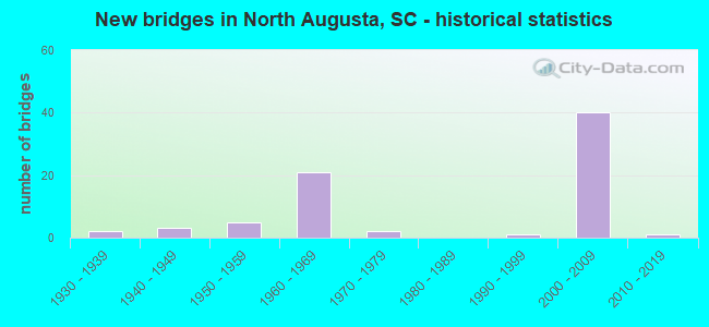
- New bridges - historical statistics
- 21930-1939
- 31940-1949
- 51950-1959
- 211960-1969
- 21970-1979
- 11990-1999
- 402000-2009
- 12010-2019

- Reconstructed bridges - Historical Statistics
- 11950-1959
- 01960-1969
- 01970-1979
- 41980-1989
- 01990-1999
- 12000-2009


- Bridge Condition - Deck
- 34.1%Very good
- 31.7%Good
- 19.5%Satisfactory
- 14.6%Fair

- Bridge Condition - Superstructure
- 53.7%Very good
- 24.4%Good
- 14.6%Satisfactory
- 2.4%Fair
- 4.9%Poor

- Bridge Condition - Substructure
- 51.2%Very good
- 26.8%Good
- 7.3%Satisfactory
- 12.2%Fair
- 2.4%Serious

- Bridge Condition - Channel
- 35.3%Very good
- 47.1%Good
- 11.8%Satisfactory
- 5.9%Fair

- Bridge Condition - Culverts
- 50.0%Good
- 50.0%Satisfactory
Find on map >> Show street view
Structure Number: 987, Location: 5 MI SE OF HEMINGWAY (Lat: 33.736575, Lng: -79.386436), Route carried "on" structure: State highway 261, Year Built: 1939, Status: Open, Structure Length: 1.04m (3.41ft), Average Daily Traffic: 2,200 (year 2020), Truck Traffic: 10%, Average Future Daily Traffic: 3,498 (year 2040), Design Load: H 15, Features Intersected: SOCEE SWAMP
Minimum Vertical Clearance: 30+ m (98+ ft), Kilometerpoint: 63.144, Lanes on structure: 2, Base Highway Network: Yes, Owner: State Highway Agency, Approaching Roadway Width: 7.3m (24.0ft), Material/Design: Concrete, Design/Construction: Culvert, Number Of Spans In Main Unit: 3, Length of Maximum Span: 3.0m (9.8ft), Curb-To-Curb Width: 11.0m (36.1ft), Out-to-Out Width: 11.6m (38.1ft)
Condition: Channel: Very good, Culverts: Good, Operating Rating: 16.8 metric tons, Method Used To Determine Operating Rating: Load and Resistance Factor Rating (LRFR) rating reported by rating factor(RF) method using HL-93 loadings, Inventory Rating: 13.0 metric tons, Method Used To Determine Inventory Rating: Load and Resistance Factor Rating (LRFR) rating reported by rating factor(RF) method using HL-93 loadings, Structural Evaluation: Meets minimum limits, Deck Geometry: Somewhat better than minimum adequacy, Waterway Adequacy: Equal to present desirable criteria, Approach Roadway Alignment: Equal to present desirable criteria, Length Of Structure Improvement: 1.04m (3.41ft), Designated Inspection Frequency: Every 24 months, Inspection Date: November 2020
Find on map >> Show street view
Structure Number: 1456, Location: 3.2 MI NW OF AIKEN CO LN (Lat: 33.588922, Lng: -82.017842), Route carried "on" structure: State highway 230, Year Built: 1948, Status: Open, Structure Length: 1.22m (4.00ft), Average Daily Traffic: 2,600 (year 2021), Truck Traffic: 10%, Average Future Daily Traffic: 3,796 (year 2041), Design Load: HS 20, Features Intersected: SWEET WATER CREEK
Minimum Vertical Clearance: 30+ m (98+ ft), Kilometerpoint: 5.311, Lanes on structure: 2, Owner: State Highway Agency, Approaching Roadway Width: 7.3m (24.0ft), Material/Design: Concrete, Design/Construction: Culvert, Number Of Spans In Main Unit: 3, Length of Maximum Span: 3.7m (12.1ft), Curb-To-Curb Width: 9.2m (30.2ft), Out-to-Out Width: 18.3m (60.0ft)
Condition: Channel: Good, Culverts: Good, Operating Rating: 4.9 metric tons, Method Used To Determine Operating Rating: Load and Resistance Factor Rating (LRFR) rating reported by rating factor(RF) method using HL-93 loadings, Inventory Rating: 3.6 metric tons, Method Used To Determine Inventory Rating: Load and Resistance Factor Rating (LRFR) rating reported by rating factor(RF) method using HL-93 loadings, Structural Evaluation: High priority of replacement, Deck Geometry: Meets minimum limits, Waterway Adequacy: Superior to present desirable criteria, Approach Roadway Alignment: Equal to present desirable criteria, Length Of Structure Improvement: 1.89m (6.20ft), Designated Inspection Frequency: Every 24 months, Inspection Date: January 2022, Bridge Improvement Cost: $191,000, Roadway Improvement Cost: $48,000, Total Project Cost: $287,000 ( Estimate for 2022)
Find on map >> Show street view
Structure Number: 1774, Location: 5 MI SE OF N AUGUSTA (Lat: 33.480525, Lng: -81.910097), Route carried "on" structure: US 278, Year Built: 1951, Status: Open, Structure Length: 5.79m (19.00ft), Average Daily Traffic: 6,700 (year 2020), Truck Traffic: 7%, Average Future Daily Traffic: 10,921 (year 2040), Design Load: HS 20, Features Intersected: SOU. RAILROAD
Minimum Vertical Clearance: 30+ m (98+ ft), Kilometerpoint: 5.317, Lanes on structure: 4, Base Highway Network: Yes, Owner: State Highway Agency, Approaching Roadway Width: 16.8m (55.1ft), Skew: 20 degrees, Material/Design: Concrete, Design/Construction: Tee Beam, Number Of Spans In Main Unit: 1, Number Of Approach Spans: 5, Length of Maximum Span: 12.2m (40.0ft), Curb or Sidewalk Widths: Left: 0.8m (2.6ft), Right: 0.8m (2.6ft), Curb-To-Curb Width: 17.7m (58.1ft), Out-to-Out Width: 18.2m (59.7ft)
Condition: Deck: Fair, Superstructure: Poor, Substructure: Fair, Operating Rating: 34.0 metric tons, Method Used To Determine Operating Rating: Load and Resistance Factor Rating (LRFR) rating reported by rating factor(RF) method using HL-93 loadings, Inventory Rating: 26.2 metric tons, Method Used To Determine Inventory Rating: Load and Resistance Factor Rating (LRFR) rating reported by rating factor(RF) method using HL-93 loadings, Structural Evaluation: Meets minimum limits, Deck Geometry: Somewhat better than minimum adequacy, Underclear: Meets minimum limits, Approach Roadway Alignment: Equal to present desirable criteria, Length Of Structure Improvement: 6.75m (22.15ft), Designated Inspection Frequency: Every 12 months, Inspection Date: January 2021, Bridge Improvement Cost: $329,000, Roadway Improvement Cost: $16,000, Total Project Cost: $362,000 ( Estimate for 2021), Deck Structure Type: Concrete Cast-file-Place, Wearing Surface/Protective System: Wearing Surface: Monolithic Concrete
Find on map >> Show street view
Structure Number: 1775, Location: 5 MI SE OF AUGUSTA (Lat: 33.478364, Lng: -81.907867), Route carried "on" structure: US 278, Year Built: 1951, Status: Open, Structure Length: 7.32m (24.02ft), Average Daily Traffic: 6,700 (year 2020), Truck Traffic: 7%, Average Future Daily Traffic: 10,921 (year 2040), Design Load: HS 20, Features Intersected: HORSE CREEK
Minimum Vertical Clearance: 30+ m (98+ ft), Kilometerpoint: 5.626, Lanes on structure: 4, Base Highway Network: Yes, Owner: State Highway Agency, Approaching Roadway Width: 16.8m (55.1ft), Material/Design: Concrete, Design/Construction: Tee Beam, Number Of Spans In Main Unit: 8, Length of Maximum Span: 9.1m (29.9ft), Curb or Sidewalk Widths: Left: 0.8m (2.6ft), Right: 0.8m (2.6ft), Curb-To-Curb Width: 17.7m (58.1ft), Out-to-Out Width: 18.2m (59.7ft)
Condition: Deck: Fair, Superstructure: Poor, Substructure: Satisfactory, Channel: Very good, Operating Rating: 41.5 metric tons, Method Used To Determine Operating Rating: Load and Resistance Factor Rating (LRFR) rating reported by rating factor(RF) method using HL-93 loadings, Inventory Rating: 32.1 metric tons, Method Used To Determine Inventory Rating: Load and Resistance Factor Rating (LRFR) rating reported by rating factor(RF) method using HL-93 loadings, Structural Evaluation: Meets minimum limits, Deck Geometry: Somewhat better than minimum adequacy, Waterway Adequacy: Better than present minimum criteria, Approach Roadway Alignment: Equal to present desirable criteria, Length Of Structure Improvement: 8.34m (27.36ft), Designated Inspection Frequency: Every 12 months, Inspection Date: January 2021, Bridge Improvement Cost: $406,000, Roadway Improvement Cost: $20,000, Total Project Cost: $447,000 ( Estimate for 2021), Deck Structure Type: Concrete Cast-file-Place, Wearing Surface/Protective System: Wearing Surface: Monolithic Concrete
Find on map >> Show street view
Structure Number: 1776, Location: 1 MI E OF N AUGUSTA (Lat: 33.494772, Lng: -81.942822), Route carried "on" structure: State highway 125, Year Built: 1951, Status: Open, Structure Length: 4.27m (14.01ft), Average Daily Traffic: 11,200 (year 2020), Truck Traffic: 3%, Average Future Daily Traffic: 11,536 (year 2040), Design Load: HS 20, Features Intersected: S-68
Minimum Vertical Clearance: 30+ m (98+ ft), Kilometerpoint: 2.966, Lanes on structure: 4, Lanes under structure: 2, Owner: State Highway Agency, Approaching Roadway Width: 8.5m (27.9ft), Skew: 1 degrees, Material/Design: Concrete, Design/Construction: Tee Beam, Number Of Spans In Main Unit: 2, Number Of Approach Spans: 2, Length of Maximum Span: 12.2m (40.0ft), Curb or Sidewalk Widths: Left: 0.8m (2.6ft), Right: 0.8m (2.6ft), Curb-To-Curb Width: 9.1m (29.9ft), Out-to-Out Width: 11.0m (36.1ft)
Condition: Deck: Satisfactory, Superstructure: Fair, Substructure: Fair, Operating Rating: 48.9 metric tons, Method Used To Determine Operating Rating: Load and Resistance Factor Rating (LRFR) rating reported by rating factor(RF) method using HL-93 loadings, Inventory Rating: 37.6 metric tons, Method Used To Determine Inventory Rating: Load and Resistance Factor Rating (LRFR) rating reported by rating factor(RF) method using HL-93 loadings, Structural Evaluation: Somewhat better than minimum adequacy, Deck Geometry: High priority of replacement, Underclear: High priority of corrective action, Approach Roadway Alignment: Equal to present desirable criteria, Length Of Structure Improvement: 5.17m (16.96ft), Designated Inspection Frequency: Every 24 months, Inspection Date: January 2020, Bridge Improvement Cost: $323,000, Roadway Improvement Cost: $81,000, Total Project Cost: $485,000 ( Estimate for 2021), Deck Structure Type: Concrete Cast-file-Place, Wearing Surface/Protective System: Wearing Surface: Monolithic Concrete
Find on map >> Show street view
Structure Number: 1845, Location: HAMBURG SC (Lat: 33.481883, Lng: -81.950181), Route carried "on" structure: US 1, Year Built: 1952, Year Reconstructed: 1959, Status: Open, Structure Length: 4.94m (16.21ft), Average Daily Traffic: 24,200 (year 2020), Truck Traffic: 6%, Average Future Daily Traffic: 26,620 (year 2040), Design Load: H 20, Features Intersected: SOUTHERN RR (NO 1)
Minimum Vertical Clearance: 30+ m (98+ ft), Kilometerpoint: 0.814, Lanes on structure: 5, Base Highway Network: Yes, Owner: State Highway Agency, Approaching Roadway Width: 16.5m (54.1ft), Skew: 33 degrees, Material/Design: Concrete, Design/Construction: Slab, Number Of Spans In Main Unit: 2, Number Of Approach Spans: 2, Length of Maximum Span: 13.7m (44.9ft), Curb or Sidewalk Widths: Left: 1.2m (3.9ft), Right: 1.2m (3.9ft), Curb-To-Curb Width: 21.9m (71.9ft), Out-to-Out Width: 25.8m (84.6ft)
Condition: Deck: Satisfactory, Superstructure: Good, Substructure: Satisfactory, Operating Rating: 7.8 metric tons, Method Used To Determine Operating Rating: Load and Resistance Factor Rating (LRFR) rating reported by rating factor(RF) method using HL-93 loadings, Inventory Rating: 6.2 metric tons, Method Used To Determine Inventory Rating: Load and Resistance Factor Rating (LRFR) rating reported by rating factor(RF) method using HL-93 loadings, Structural Evaluation: High priority of replacement, Deck Geometry: Somewhat better than minimum adequacy, Underclear: Somewhat better than minimum adequacy, Approach Roadway Alignment: Better than present minimum criteria, Length Of Structure Improvement: 5.87m (19.26ft), Designated Inspection Frequency: Every 24 months, Inspection Date: January 2020, Bridge Improvement Cost: $742,000, Roadway Improvement Cost: $186,000, Total Project Cost: $1,113,000 ( Estimate for 2021), Deck Structure Type: Concrete Cast-file-Place, Wearing Surface/Protective System: Wearing Surface: Bituminous
Find on map >> Show street view
Structure Number: 315, Location: AT N. AUGUSTA (Lat: 33.478203, Lng: -81.953867), Route carried "on" structure: US 1, Year Built: 1960, Year Reconstructed: 2009, Status: Open, Structure Length: 3.98m (13.06ft), Average Daily Traffic: 24,200 (year 2020), Truck Traffic: 6%, Average Future Daily Traffic: 26,620 (year 2040), Design Load: HS 20, Features Intersected: U S 1 CON INTERCHANGE
Minimum Vertical Clearance: 30+ m (98+ ft), Kilometerpoint: 0.283, Lanes on structure: 4, Lanes under structure: 2, Base Highway Network: Yes, Owner: State Highway Agency, Approaching Roadway Width: 17.4m (57.1ft), Skew: 31 degrees, Material/Design: Concrete continuous, Design/Construction: Slab, Number Of Spans In Main Unit: 1, Number Of Approach Spans: 2, Length of Maximum Span: 15.8m (51.8ft), Curb or Sidewalk Widths: Left: 0.9m (3.0ft), Right: 0.6m (2.0ft), Curb-To-Curb Width: 18.3m (60.0ft), Out-to-Out Width: 21.5m (70.5ft)
Condition: Deck: Good, Superstructure: Very good, Substructure: Good, Operating Rating: 30.1 metric tons, Method Used To Determine Operating Rating: Load and Resistance Factor Rating (LRFR) rating reported by rating factor(RF) method using HL-93 loadings, Inventory Rating: 23.3 metric tons, Method Used To Determine Inventory Rating: Load and Resistance Factor Rating (LRFR) rating reported by rating factor(RF) method using HL-93 loadings, Structural Evaluation: Somewhat better than minimum adequacy, Deck Geometry: Somewhat better than minimum adequacy, Underclear: Somewhat better than minimum adequacy, Approach Roadway Alignment: Better than present minimum criteria, Length Of Structure Improvement: 3.98m (13.06ft), Designated Inspection Frequency: Every 24 months, Inspection Date: January 2020, Deck Structure Type: Concrete Cast-file-Place, Wearing Surface/Protective System: Wearing Surface: Bituminous
Find on map >> Show street view
Structure Number: 3151, Location: N AUGUSTA (Lat: 33.480211, Lng: -81.952283), Route carried "on" structure: US 1, Year Built: 1960, Status: Open, Structure Length: 6.40m (21.00ft), Average Daily Traffic: 24,200 (year 2020), Truck Traffic: 6%, Average Future Daily Traffic: 26,620 (year 2040), Design Load: H 20, Features Intersected: L-4772
Minimum Vertical Clearance: 30+ m (98+ ft), Kilometerpoint: 0.536, Lanes on structure: 4, Lanes under structure: 2, Base Highway Network: Yes, Owner: State Highway Agency, Approaching Roadway Width: 17.1m (56.1ft), Skew: 30 degrees, Material/Design: Concrete, Design/Construction: Tee Beam, Number Of Spans In Main Unit: 6, Length of Maximum Span: 10.7m (35.1ft), Curb or Sidewalk Widths: Left: 0.7m (2.3ft), Right: 0.7m (2.3ft), Curb-To-Curb Width: 20.1m (65.9ft), Out-to-Out Width: 23.2m (76.1ft)
Condition: Deck: Satisfactory, Superstructure: Satisfactory, Substructure: Good, Operating Rating: 38.2 metric tons, Method Used To Determine Operating Rating: Load and Resistance Factor Rating (LRFR) rating reported by rating factor(RF) method using HL-93 loadings, Inventory Rating: 29.5 metric tons, Method Used To Determine Inventory Rating: Load and Resistance Factor Rating (LRFR) rating reported by rating factor(RF) method using HL-93 loadings, Structural Evaluation: Equal to present minimum criteria, Deck Geometry: Better than present minimum criteria, Underclear: Meets minimum limits, Approach Roadway Alignment: Better than present minimum criteria, Length Of Structure Improvement: 6.40m (21.00ft), Designated Inspection Frequency: Every 24 months, Inspection Date: January 2020, Deck Structure Type: Concrete Cast-file-Place, Wearing Surface/Protective System: Wearing Surface: Bituminous
Find on map >> Show street view
Structure Number: 3152, Location: 1 MI S OF N AUGUSTA (Lat: 33.483517, Lng: -81.947900), Route carried "on" structure: US 25, Year Built: 1960, Status: Open, Structure Length: 6.58m (21.59ft), Average Daily Traffic: 12,200 (year 2020), Truck Traffic: 4%, Average Future Daily Traffic: 13,420 (year 2040), Design Load: HS 20+Mod, Features Intersected: U.S. 1
Minimum Vertical Clearance: 30+ m (98+ ft), Kilometerpoint: 1.117, Lanes on structure: 2, Lanes under structure: 5, Base Highway Network: Yes, Owner: State Highway Agency, Approaching Roadway Width: 8.5m (27.9ft), Skew: 1 degrees, Material/Design: Prestressed concrete, Design/Construction: Stringer/Multi-beam, Number Of Spans In Main Unit: 2, Number Of Approach Spans: 2, Length of Maximum Span: 17.7m (58.1ft), Curb-To-Curb Width: 8.5m (27.9ft), Out-to-Out Width: 10.2m (33.5ft)
Condition: Deck: Satisfactory, Superstructure: Satisfactory, Substructure: Satisfactory, Operating Rating: 64.5 metric tons, Method Used To Determine Operating Rating: Load and Resistance Factor Rating (LRFR) rating reported by rating factor(RF) method using HL-93 loadings, Inventory Rating: 44.1 metric tons, Method Used To Determine Inventory Rating: Load and Resistance Factor Rating (LRFR) rating reported by rating factor(RF) method using HL-93 loadings, Structural Evaluation: Equal to present minimum criteria, Deck Geometry: Meets minimum limits, Underclear: High priority of corrective action, Approach Roadway Alignment: Somewhat better than minimum adequacy, Length Of Structure Improvement: 7.58m (24.87ft), Designated Inspection Frequency: Every 24 months, Inspection Date: January 2020, Bridge Improvement Cost: $506,000, Roadway Improvement Cost: $127,000, Total Project Cost: $759,000 ( Estimate for 2021), Deck Structure Type: Concrete Cast-file-Place, Wearing Surface/Protective System: Wearing Surface: Bituminous
Find on map >> Show street view
Structure Number: 3154, Location: 3MI N OF N. AUGUSTA (Lat: 33.543231, Lng: -81.995569), Route carried "on" structure: State highway 230, Year Built: 1946, Year Reconstructed: 1991, Status: Open, Structure Length: 1.30m (4.27ft), Average Daily Traffic: 12,600 (year 2021), Truck Traffic: 5%, Average Future Daily Traffic: 12,978 (year 2041), Design Load: H 15, Features Intersected: POLE BRANCH
Minimum Vertical Clearance: 30+ m (98+ ft), Kilometerpoint: 6.210, Lanes on structure: 2, Owner: State Highway Agency, Approaching Roadway Width: 7.3m (24.0ft), Material/Design: Concrete, Design/Construction: Culvert, Number Of Spans In Main Unit: 4, Length of Maximum Span: 3.0m (9.8ft), Curb-To-Curb Width: 24.4m (80.1ft), Out-to-Out Width: 32.3m (106.0ft)
Condition: Channel: Satisfactory, Culverts: Satisfactory, Operating Rating: 12.0 metric tons, Method Used To Determine Operating Rating: Load and Resistance Factor Rating (LRFR) rating reported by rating factor(RF) method using HL-93 loadings, Inventory Rating: 9.4 metric tons, Method Used To Determine Inventory Rating: Load and Resistance Factor Rating (LRFR) rating reported by rating factor(RF) method using HL-93 loadings, Structural Evaluation: High priority of corrective action, Deck Geometry: Superior to present desirable criteria, Waterway Adequacy: Better than present minimum criteria, Approach Roadway Alignment: Equal to present desirable criteria, Length Of Structure Improvement: 1.97m (6.46ft), Designated Inspection Frequency: Every 24 months, Inspection Date: January 2022, Deck Structure Type: Concrete Cast-file-Place, Wearing Surface/Protective System: Wearing Surface: Bituminous
Find on map >> Show street view
Structure Number: 3155, Location: 3 MI N OF N AUGUSTA (Lat: 33.544100, Lng: -81.996636), Route carried "on" structure: State highway 230, Year Built: 1946, Year Reconstructed: 1991, Status: Open, Structure Length: 0.98m (3.22ft), Average Daily Traffic: 12,600 (year 2021), Truck Traffic: 5%, Average Future Daily Traffic: 12,978 (year 2041), Design Load: H 15, Features Intersected: POLE BRANCH
Minimum Vertical Clearance: 30+ m (98+ ft), Kilometerpoint: 6.341, Lanes on structure: 2, Owner: State Highway Agency, Approaching Roadway Width: 7.3m (24.0ft), Material/Design: Concrete, Design/Construction: Culvert, Number Of Spans In Main Unit: 3, Length of Maximum Span: 3.0m (9.8ft), Curb-To-Curb Width: 19.1m (62.7ft), Out-to-Out Width: 19.7m (64.6ft)
Condition: Channel: Good, Culverts: Good, Operating Rating: 48.0 metric tons, Method Used To Determine Operating Rating: Load and Resistance Factor Rating (LRFR) rating reported by rating factor(RF) method using HL-93 loadings, Inventory Rating: 37.3 metric tons, Method Used To Determine Inventory Rating: Load and Resistance Factor Rating (LRFR) rating reported by rating factor(RF) method using HL-93 loadings, Structural Evaluation: Better than present minimum criteria, Deck Geometry: Superior to present desirable criteria, Waterway Adequacy: Better than present minimum criteria, Approach Roadway Alignment: Equal to present desirable criteria, Length Of Structure Improvement: 0.98m (3.22ft), Designated Inspection Frequency: Every 24 months, Inspection Date: January 2022
Find on map >> Show street view
Structure Number: 411, Location: 14.1MI SW EDGEFIELD (Lat: 33.586875, Lng: -81.965928), Route carried "on" structure: State highway 178, Year Built: 1963, Status: Open, Structure Length: 4.02m (13.19ft), Average Daily Traffic: 1,200 (year 2021), Truck Traffic: 5%, Average Future Daily Traffic: 1,536 (year 2041), Design Load: H 15, Features Intersected: ABANDONED SOUTHERN RR
Minimum Vertical Clearance: 30+ m (98+ ft), Kilometerpoint: 5.086, Lanes on structure: 2, Owner: State Highway Agency, Approaching Roadway Width: 6.7m (22.0ft), Material/Design: Prestressed concrete, Design/Construction: Stringer/Multi-beam, Number Of Spans In Main Unit: 3, Length of Maximum Span: 13.1m (43.0ft), Curb-To-Curb Width: 8.0m (26.2ft), Out-to-Out Width: 9.2m (30.2ft)
Condition: Deck: Satisfactory, Superstructure: Good, Substructure: Good, Operating Rating: 43.7 metric tons, Method Used To Determine Operating Rating: Load and Resistance Factor Rating (LRFR) rating reported by rating factor(RF) method using HL-93 loadings, Inventory Rating: 29.8 metric tons, Method Used To Determine Inventory Rating: Load and Resistance Factor Rating (LRFR) rating reported by rating factor(RF) method using HL-93 loadings, Structural Evaluation: Better than present minimum criteria, Deck Geometry: Meets minimum limits, Approach Roadway Alignment: Equal to present desirable criteria, Length Of Structure Improvement: 4.02m (13.19ft), Designated Inspection Frequency: Every 24 months, Inspection Date: Febuary 2021, Deck Structure Type: Concrete Cast-file-Place, Wearing Surface/Protective System: Wearing Surface: Monolithic Concrete
Find on map >> Show street view
Structure Number: 4442, Location: IN NORTH AUGUSTA (Lat: 33.531972, Lng: -81.903261), Route carried "on" structure: State highway 1760, Year Built: 1965, Status: Posted for load, Structure Length: 1.37m (4.49ft), Average Daily Traffic: 2,600 (year 2020), Truck Traffic: 6%, Average Future Daily Traffic: 3,406 (year 2040), Design Load: H 10, Features Intersected: TRIB TO LTL HORSE CRK
Minimum Vertical Clearance: 30+ m (98+ ft), Kilometerpoint: 1.273, Lanes on structure: 2, Owner: State Highway Agency, Approaching Roadway Width: 6.4m (21.0ft), Material/Design: Concrete, Design/Construction: Slab, Number Of Spans In Main Unit: 3, Length of Maximum Span: 4.6m (15.1ft), Curb-To-Curb Width: 7.9m (25.9ft), Out-to-Out Width: 8.4m (27.6ft)
Condition: Deck: Satisfactory, Superstructure: Satisfactory, Substructure: Fair, Channel: Good, Operating Rating: 21.1 metric tons, Method Used To Determine Operating Rating: Load and Resistance Factor Rating (LRFR) rating reported by rating factor(RF) method using HL-93 loadings, Inventory Rating: 16.2 metric tons, Method Used To Determine Inventory Rating: Load and Resistance Factor Rating (LRFR) rating reported by rating factor(RF) method using HL-93 loadings, Structural Evaluation: Meets minimum limits, Deck Geometry: High priority of corrective action, Waterway Adequacy: Equal to present minimum criteria, Approach Roadway Alignment: Better than present minimum criteria, Bridge Posting: Required (Relationship of Operating Rating to Maximum Legal Load: 20.0 - 29.9% below), Length Of Structure Improvement: 2.06m (6.76ft), Designated Inspection Frequency: Every 24 months, Other Special Inspection Frequency: Every 24 months, Inspection Date: January 2021, Other Special Inspection Date: July 2021, Bridge Improvement Cost: $208,000, Roadway Improvement Cost: $52,000, Total Project Cost: $312,000 ( Estimate for 2021), Deck Structure Type: Concrete Cast-file-Place, Wearing Surface/Protective System: Wearing Surface: Bituminous
Find on map >> Show street view
Structure Number: 4687, Location: 1 MI N OF N AUGUSTA (Lat: 33.542000, Lng: -81.984400), Route carried "on" structure: Interstate 20, Year Built: 1966, Status: Open, Structure Length: 0.82m (2.69ft), Average Daily Traffic: 40,500 (year 2020), Truck Traffic: 9%, Average Future Daily Traffic: 49,815 (year 2040), Design Load: H 20, Features Intersected: FOX CREEK
Minimum Vertical Clearance: 30+ m (98+ ft), Kilometerpoint: 2.876, Lanes on structure: 4, Base Highway Network: Yes, Owner: State Highway Agency, Approaching Roadway Width: 23.2m (76.1ft), Skew: 1 degrees, Material/Design: Concrete, Design/Construction: Culvert, Number Of Spans In Main Unit: 2, Length of Maximum Span: 4.0m (13.1ft), Curb-To-Curb Width: 45.7m (149.9ft), Out-to-Out Width: 45.7m (149.9ft)
Condition: Channel: Good, Culverts: Satisfactory, Operating Rating: 47.0 metric tons, Method Used To Determine Operating Rating: Load and Resistance Factor Rating (LRFR) rating reported by rating factor(RF) method using HL-93 loadings, Inventory Rating: 36.3 metric tons, Method Used To Determine Inventory Rating: Load and Resistance Factor Rating (LRFR) rating reported by rating factor(RF) method using HL-93 loadings, Structural Evaluation: Equal to present minimum criteria, Deck Geometry: Superior to present desirable criteria, Waterway Adequacy: Equal to present minimum criteria, Approach Roadway Alignment: Equal to present desirable criteria, Length Of Structure Improvement: 0.82m (2.69ft), Designated Inspection Frequency: Every 24 months, Inspection Date: January 2020
Find on map >> Show street view
Structure Number: 4688, Location: 5 MI N OF BURNETTOWN (Lat: 33.582736, Lng: -81.890767), Route carried "on" structure: Interstate 20, Year Built: 1966, Status: Open, Structure Length: 0.73m (2.40ft), Average Daily Traffic: 37,100 (year 2020), Truck Traffic: 19%, Average Future Daily Traffic: 45,633 (year 2040), Design Load: HS 20, Features Intersected: HIGH TOWER BRANCH
Minimum Vertical Clearance: 30+ m (98+ ft), Kilometerpoint: 12.878, Lanes on structure: 4, Base Highway Network: Yes, Owner: State Highway Agency, Approaching Roadway Width: 23.2m (76.1ft), Material/Design: Concrete, Design/Construction: Culvert, Number Of Spans In Main Unit: 2, Length of Maximum Span: 3.0m (9.8ft), Curb-To-Curb Width: 33.5m (109.9ft), Out-to-Out Width: 45.7m (149.9ft)
Condition: Channel: Very good, Culverts: Satisfactory, Inventory Rating: 97.2 metric tons, Method Used To Determine Inventory Rating: Load and Resistance Factor Rating (LRFR) rating reported by rating factor(RF) method using HL-93 loadings, Structural Evaluation: Equal to present minimum criteria, Deck Geometry: Superior to present desirable criteria, Waterway Adequacy: Better than present minimum criteria, Approach Roadway Alignment: Equal to present desirable criteria, Length Of Structure Improvement: 0.73m (2.40ft), Designated Inspection Frequency: Every 24 months, Inspection Date: Febuary 2020
Find on map >> Show street view
Structure Number: 469, Location: 2 MI N OF N AUGUSTA (Lat: 33.545625, Lng: -81.968189), Route carried "on" structure: Interstate 20, Year Built: 1966, Status: Open, Structure Length: 5.03m (16.50ft), Average Daily Traffic: 20,250 (year 2020), Truck Traffic: 9%, Average Future Daily Traffic: 24,908 (year 2040), Design Load: HS 20, Features Intersected: GA & FLA RR (NO TRACKS)
Minimum Vertical Clearance: 30+ m (98+ ft), Kilometerpoint: 4.321, Lanes on structure: 2, Base Highway Network: Yes, Owner: State Highway Agency, Approaching Roadway Width: 11.3m (37.1ft), Skew: 10 degrees, Material/Design: Prestressed concrete, Design/Construction: Stringer/Multi-beam, Number Of Spans In Main Unit: 3, Length of Maximum Span: 16.8m (55.1ft), Curb-To-Curb Width: 11.0m (36.1ft), Out-to-Out Width: 12.4m (40.7ft)
Condition: Deck: Fair, Superstructure: Satisfactory, Substructure: Good, Operating Rating: 61.2 metric tons, Method Used To Determine Operating Rating: Load and Resistance Factor Rating (LRFR) rating reported by rating factor(RF) method using HL-93 loadings, Inventory Rating: 38.9 metric tons, Method Used To Determine Inventory Rating: Load and Resistance Factor Rating (LRFR) rating reported by rating factor(RF) method using HL-93 loadings, Structural Evaluation: Equal to present minimum criteria, Deck Geometry: Somewhat better than minimum adequacy, Approach Roadway Alignment: Equal to present desirable criteria, Length Of Structure Improvement: 5.03m (16.50ft), Designated Inspection Frequency: Every 24 months, Inspection Date: January 2020, Deck Structure Type: Concrete Cast-file-Place, Wearing Surface/Protective System: Wearing Surface: Monolithic Concrete
Find on map >> Show street view
Structure Number: 4691, Location: 2 MI N OF AUGUSTA (Lat: 33.546075, Lng: -81.968289), Route carried "on" structure: Interstate 20, Year Built: 1966, Status: Open, Structure Length: 5.03m (16.50ft), Average Daily Traffic: 20,250 (year 2020), Truck Traffic: 9%, Average Future Daily Traffic: 24,908 (year 2040), Design Load: HS 20, Features Intersected: ABANDOND RR (NO TRACKS)
Minimum Vertical Clearance: 30+ m (98+ ft), Kilometerpoint: 4.408, Lanes on structure: 2, Base Highway Network: Yes, Owner: State Highway Agency, Approaching Roadway Width: 11.0m (36.1ft), Skew: 10 degrees, Material/Design: Prestressed concrete, Design/Construction: Stringer/Multi-beam, Number Of Spans In Main Unit: 3, Length of Maximum Span: 16.8m (55.1ft), Curb-To-Curb Width: 11.0m (36.1ft), Out-to-Out Width: 12.4m (40.7ft)
Condition: Deck: Fair, Superstructure: Satisfactory, Substructure: Good, Operating Rating: 61.2 metric tons, Method Used To Determine Operating Rating: Load and Resistance Factor Rating (LRFR) rating reported by rating factor(RF) method using HL-93 loadings, Inventory Rating: 38.9 metric tons, Method Used To Determine Inventory Rating: Load and Resistance Factor Rating (LRFR) rating reported by rating factor(RF) method using HL-93 loadings, Structural Evaluation: Equal to present minimum criteria, Deck Geometry: Somewhat better than minimum adequacy, Approach Roadway Alignment: Equal to present desirable criteria, Length Of Structure Improvement: 5.03m (16.50ft), Designated Inspection Frequency: Every 24 months, Inspection Date: January 2020, Deck Structure Type: Concrete Cast-file-Place, Wearing Surface/Protective System: Wearing Surface: Monolithic Concrete
Find on map >> Show street view
Structure Number: 4692, Location: 5 MI N N AUGUSTA (Lat: 33.564900, Lng: -81.936789), Route carried "on" structure: US 25, Year Built: 2008, Status: Open, Structure Length: 6.00m (19.69ft), Average Daily Traffic: 26,900 (year 2020), Truck Traffic: 8%, Average Future Daily Traffic: 29,590 (year 2040), Design Load: HS 25 or greater, Features Intersected: I-20
Minimum Vertical Clearance: 30+ m (98+ ft), Kilometerpoint: 11.267, Lanes on structure: 7, Lanes under structure: 6, Base Highway Network: Yes, Owner: State Highway Agency, Approaching Roadway Width: 35.1m (115.2ft), Skew: 10 degrees, Material/Design: Prestressed concrete continuous, Design/Construction: Stringer/Multi-beam, Number Of Spans In Main Unit: 1, Number Of Approach Spans: 1, Length of Maximum Span: 31.7m (104.0ft), Curb or Sidewalk Widths: Left: 1.7m (5.6ft), Right: 1.7m (5.6ft), Curb-To-Curb Width: 35.1m (115.2ft), Out-to-Out Width: 38.4m (126.0ft)
Condition: Deck: Good, Superstructure: Very good, Substructure: Very good, Operating Rating: 74.2 metric tons, Method Used To Determine Operating Rating: Load and Resistance Factor Rating (LRFR) rating reported by rating factor(RF) method using HL-93 loadings, Inventory Rating: 50.9 metric tons, Method Used To Determine Inventory Rating: Load and Resistance Factor Rating (LRFR) rating reported by rating factor(RF) method using HL-93 loadings, Structural Evaluation: Equal to present desirable criteria, Deck Geometry: Superior to present desirable criteria, Underclear: Equal to present minimum criteria, Approach Roadway Alignment: Better than present minimum criteria, Length Of Structure Improvement: 6.00m (19.69ft), Designated Inspection Frequency: Every 24 months, Inspection Date: January 2020, Deck Structure Type: Concrete Cast-file-Place, Wearing Surface/Protective System: Wearing Surface: Monolithic Concrete
Find on map >> Show street view
Structure Number: 4695, Location: 2.0 MI NE N AUGUSTA (Lat: 33.548894, Lng: -81.957858), Route carried "on" structure: State highway 45, Year Built: 1966, Status: Open, Structure Length: 8.84m (29.00ft), Average Daily Traffic: 7,200 (year 2020), Truck Traffic: 3%, Average Future Daily Traffic: 7,416 (year 2040), Design Load: HS 15, Features Intersected: I-20
Minimum Vertical Clearance: 30+ m (98+ ft), Kilometerpoint: 5.367, Lanes on structure: 2, Lanes under structure: 4, Owner: State Highway Agency, Approaching Roadway Width: 7.3m (24.0ft), Skew: 3 degrees, Material/Design: Steel, Design/Construction: Stringer/Multi-beam, Number Of Spans In Main Unit: 3, Number Of Approach Spans: 1, Length of Maximum Span: 24.4m (80.1ft), Curb-To-Curb Width: 7.9m (25.9ft), Out-to-Out Width: 9.7m (31.8ft)
Condition: Deck: Fair, Superstructure: Good, Substructure: Good, Operating Rating: 50.5 metric tons, Method Used To Determine Operating Rating: Load and Resistance Factor Rating (LRFR) rating reported by rating factor(RF) method using HL-93 loadings, Inventory Rating: 39.2 metric tons, Method Used To Determine Inventory Rating: Load and Resistance Factor Rating (LRFR) rating reported by rating factor(RF) method using HL-93 loadings, Structural Evaluation: Better than present minimum criteria, Deck Geometry: High priority of corrective action, Underclear: Meets minimum limits, Approach Roadway Alignment: Equal to present desirable criteria, Length Of Structure Improvement: 9.92m (32.55ft), Designated Inspection Frequency: Every 24 months, Inspection Date: January 2021, Bridge Improvement Cost: $536,000, Roadway Improvement Cost: $134,000, Total Project Cost: $804,000 ( Estimate for 2021), Deck Structure Type: Concrete Cast-file-Place, Wearing Surface/Protective System: Wearing Surface: Monolithic Concrete
Find on map >> Show street view
Structure Number: 52, Location: 5.0 MI NE N AUGUSTA (Lat: 33.578131, Lng: -81.901725), Route carried "on" structure: State highway 253, Year Built: 1968, Status: Open, Structure Length: 8.32m (27.30ft), Average Daily Traffic: 1,250 (year 2020), Truck Traffic: 5%, Average Future Daily Traffic: 1,600 (year 2040), Design Load: HS 15, Features Intersected: I-20
Minimum Vertical Clearance: 30+ m (98+ ft), Kilometerpoint: 3.879, Lanes on structure: 2, Lanes under structure: 4, Owner: State Highway Agency, Approaching Roadway Width: 6.7m (22.0ft), Material/Design: Prestressed concrete, Design/Construction: Stringer/Multi-beam, Number Of Spans In Main Unit: 3, Number Of Approach Spans: 1, Length of Maximum Span: 23.2m (76.1ft), Curb-To-Curb Width: 7.9m (25.9ft), Out-to-Out Width: 9.1m (29.9ft)
Condition: Deck: Satisfactory, Superstructure: Good, Substructure: Good, Operating Rating: 51.5 metric tons, Method Used To Determine Operating Rating: Load and Resistance Factor Rating (LRFR) rating reported by rating factor(RF) method using HL-93 loadings, Inventory Rating: 27.5 metric tons, Method Used To Determine Inventory Rating: Load and Resistance Factor Rating (LRFR) rating reported by rating factor(RF) method using HL-93 loadings, Structural Evaluation: Equal to present minimum criteria, Deck Geometry: Meets minimum limits, Underclear: Meets minimum limits, Approach Roadway Alignment: Equal to present desirable criteria, Length Of Structure Improvement: 8.32m (27.30ft), Designated Inspection Frequency: Every 24 months, Inspection Date: January 2021, Deck Structure Type: Concrete Cast-file-Place, Wearing Surface/Protective System: Wearing Surface: Monolithic Concrete
Find on map >> Show street view
Structure Number: 545, Location: 7.0 MI NW AIKEN (Lat: 33.591611, Lng: -81.877661), Route carried "on" structure: State highway 779, Year Built: 1969, Status: Open, Structure Length: 7.50m (24.61ft), Average Daily Traffic: 1,350 (year 2020), Truck Traffic: 13%, Average Future Daily Traffic: 1,796 (year 2040), Design Load: HS 15, Features Intersected: I-20
Minimum Vertical Clearance: 30+ m (98+ ft), Kilometerpoint: 4.015, Lanes on structure: 2, Lanes under structure: 4, Owner: State Highway Agency, Approaching Roadway Width: 6.7m (22.0ft), Material/Design: Steel, Design/Construction: Stringer/Multi-beam, Number Of Spans In Main Unit: 2, Number Of Approach Spans: 2, Length of Maximum Span: 26.2m (86.0ft), Curb-To-Curb Width: 10.4m (34.1ft), Out-to-Out Width: 11.5m (37.7ft)
Condition: Deck: Good, Superstructure: Good, Substructure: Very good, Operating Rating: 48.3 metric tons, Method Used To Determine Operating Rating: Load and Resistance Factor Rating (LRFR) rating reported by rating factor(RF) method using HL-93 loadings, Inventory Rating: 36.9 metric tons, Method Used To Determine Inventory Rating: Load and Resistance Factor Rating (LRFR) rating reported by rating factor(RF) method using HL-93 loadings, Structural Evaluation: Better than present minimum criteria, Deck Geometry: Equal to present minimum criteria, Underclear: Equal to present minimum criteria, Approach Roadway Alignment: Equal to present desirable criteria, Length Of Structure Improvement: 7.50m (24.61ft), Designated Inspection Frequency: Every 24 months, Inspection Date: January 2021, Deck Structure Type: Concrete Cast-file-Place, Wearing Surface/Protective System: Wearing Surface: Bituminous
Find on map >> Show street view
Structure Number: 5714, Location: 15.9MI SW EDGEFIELD (Lat: 33.561206, Lng: -81.986547), Route carried "on" structure: State highway 340, Year Built: 2013, Status: Open, Structure Length: 2.13m (6.99ft), Average Daily Traffic: 1,100 (year 2020), Truck Traffic: 5%, Average Future Daily Traffic: 1,408 (year 2040), Design Load: HS 25 or greater, Features Intersected: FOX CREEK
Minimum Vertical Clearance: 30+ m (98+ ft), Kilometerpoint: 0.771, Lanes on structure: 2, Owner: State Highway Agency, Approaching Roadway Width: 6.4m (21.0ft), Material/Design: Concrete, Design/Construction: Slab, Number Of Spans In Main Unit: 1, Length of Maximum Span: 21.3m (69.9ft), Curb-To-Curb Width: 10.1m (33.1ft), Out-to-Out Width: 11.0m (36.1ft)
Condition: Deck: Very good, Superstructure: Very good, Substructure: Very good, Channel: Fair, Operating Rating: 65.1 metric tons, Method Used To Determine Operating Rating: Load and Resistance Factor Rating (LRFR) rating reported by rating factor(RF) method using HL-93 loadings, Inventory Rating: 50.2 metric tons, Method Used To Determine Inventory Rating: Load and Resistance Factor Rating (LRFR) rating reported by rating factor(RF) method using HL-93 loadings, Structural Evaluation: Equal to present desirable criteria, Deck Geometry: Somewhat better than minimum adequacy, Waterway Adequacy: Superior to present desirable criteria, Approach Roadway Alignment: Equal to present desirable criteria, Length Of Structure Improvement: 2.13m (6.99ft), Designated Inspection Frequency: Every 24 months, Inspection Date: Febuary 2021, Deck Structure Type: Concrete Precast Panels, Wearing Surface/Protective System: Wearing Surface: Bituminous
Find on map >> Show street view
Structure Number: 6835, Location: N AUGUSTA (Lat: 33.538403, Lng: -81.977164), Route carried "on" structure: County highway 3114, Year Built: 1976, Status: Open, Structure Length: 0.91m (2.99ft), Average Daily Traffic: 150 (year 2020), Truck Traffic: 5%, Average Future Daily Traffic: 192 (year 2040), Design Load: H 15, Features Intersected: POLE BRANCH
Minimum Vertical Clearance: 30+ m (98+ ft), Kilometerpoint: 0.251, Lanes on structure: 2, Owner: County Highway Agency, Approaching Roadway Width: 7.3m (24.0ft), Material/Design: Prestressed concrete, Design/Construction: Stringer/Multi-beam, Number Of Spans In Main Unit: 1, Length of Maximum Span: 9.1m (29.9ft), Curb-To-Curb Width: 8.0m (26.2ft), Out-to-Out Width: 8.4m (27.6ft)
Condition: Deck: Good, Superstructure: Good, Substructure: Serious, Channel: Very good, Operating Rating: 41.8 metric tons, Method Used To Determine Operating Rating: Load and Resistance Factor Rating (LRFR) rating reported by rating factor(RF) method using HL-93 loadings, Inventory Rating: 29.5 metric tons, Method Used To Determine Inventory Rating: Load and Resistance Factor Rating (LRFR) rating reported by rating factor(RF) method using HL-93 loadings, Structural Evaluation: High priority of corrective action, Deck Geometry: Somewhat better than minimum adequacy, Waterway Adequacy: Better than present minimum criteria, Approach Roadway Alignment: Equal to present desirable criteria, Length Of Structure Improvement: 1.55m (5.09ft), Designated Inspection Frequency: Every 12 months, Inspection Date: January 2021, Bridge Improvement Cost: $124,000, Roadway Improvement Cost: $31,000, Total Project Cost: $186,000 ( Estimate for 2021), Deck Structure Type: Concrete Cast-file-Place, Wearing Surface/Protective System: Wearing Surface: Bituminous
Find on map >> Show street view
Structure Number: 6859, Location: 14.9MI SW EDGEFIELD (Lat: 33.585281, Lng: -82.013128), Route carried "on" structure: State highway 339, Year Built: 1976, Status: Posted for load, Structure Length: 1.83m (6.00ft), Average Daily Traffic: 750 (year 2020), Truck Traffic: 5%, Average Future Daily Traffic: 960 (year 2040), Design Load: H 10, Features Intersected: SWEETWATER CREEK
Minimum Vertical Clearance: 30+ m (98+ ft), Kilometerpoint: 0.455, Lanes on structure: 2, Owner: State Highway Agency, Approaching Roadway Width: 6.1m (20.0ft), Material/Design: Concrete, Design/Construction: Slab, Number Of Spans In Main Unit: 4, Length of Maximum Span: 4.6m (15.1ft), Curb-To-Curb Width: 8.0m (26.2ft), Out-to-Out Width: 8.4m (27.6ft)
Condition: Deck: Good, Superstructure: Good, Substructure: Fair, Channel: Good, Operating Rating: 21.4 metric tons, Method Used To Determine Operating Rating: Load and Resistance Factor Rating (LRFR) rating reported by rating factor(RF) method using HL-93 loadings, Inventory Rating: 16.5 metric tons, Method Used To Determine Inventory Rating: Load and Resistance Factor Rating (LRFR) rating reported by rating factor(RF) method using HL-93 loadings, Structural Evaluation: Meets minimum limits, Deck Geometry: Somewhat better than minimum adequacy, Waterway Adequacy: Superior to present desirable criteria, Approach Roadway Alignment: Equal to present desirable criteria, Bridge Posting: Required (Relationship of Operating Rating to Maximum Legal Load: 20.0 - 29.9% below), Length Of Structure Improvement: 1.83m (6.00ft), Designated Inspection Frequency: Every 24 months, Inspection Date: Febuary 2021, Deck Structure Type: Concrete Precast Panels, Wearing Surface/Protective System: Wearing Surface: Bituminous
Find on map >> Show street view
Structure Number: 8507, Location: 3 MI N BURNETTOWN SC (Lat: 33.545711, Lng: -81.885006), Route carried "on" structure: State highway 254, Year Built: 1992, Status: Open, Structure Length: 6.44m (21.13ft), Average Daily Traffic: 5,500 (year 2020), Truck Traffic: 7%, Average Future Daily Traffic: 7,205 (year 2040), Design Load: HS 20, Features Intersected: LITTLE HORSE CREEK
Minimum Vertical Clearance: 30+ m (98+ ft), Kilometerpoint: 5.248, Lanes on structure: 2, Owner: State Highway Agency, Approaching Roadway Width: 8.4m (27.6ft), Material/Design: Prestressed concrete, Design/Construction: Stringer/Multi-beam, Number Of Spans In Main Unit: 2, Number Of Approach Spans: 2, Length of Maximum Span: 25.9m (85.0ft), Curb-To-Curb Width: 11.0m (36.1ft), Out-to-Out Width: 11.9m (39.0ft)
Condition: Deck: Good, Superstructure: Very good, Substructure: Good, Channel: Good, Operating Rating: 59.0 metric tons, Method Used To Determine Operating Rating: Load and Resistance Factor Rating (LRFR) rating reported by rating factor(RF) method using HL-93 loadings, Inventory Rating: 45.7 metric tons, Method Used To Determine Inventory Rating: Load and Resistance Factor Rating (LRFR) rating reported by rating factor(RF) method using HL-93 loadings, Structural Evaluation: Better than present minimum criteria, Deck Geometry: Meets minimum limits, Waterway Adequacy: Better than present minimum criteria, Approach Roadway Alignment: Better than present minimum criteria, Length Of Structure Improvement: 6.44m (21.13ft), Designated Inspection Frequency: Every 24 months, Inspection Date: January 2021, Deck Structure Type: Concrete Cast-file-Place, Wearing Surface/Protective System: Wearing Surface: Monolithic Concrete
Find on map >> Show street view
Structure Number: 8603, Location: 2 MI W OF N AUGUSTA (Lat: 33.540083, Lng: -81.991808), Route carried "on" structure: State highway 230, Year Built: 1966, Year Reconstructed: 1993, Status: Open, Structure Length: 9.94m (32.61ft), Average Daily Traffic: 16,800 (year 2020), Truck Traffic: 4%, Average Future Daily Traffic: 17,304 (year 2040), Design Load: HS 20+Mod, Features Intersected: I-20
Minimum Vertical Clearance: 30+ m (98+ ft), Kilometerpoint: 5.676, Lanes on structure: 6, Lanes under structure: 6, Owner: State Highway Agency, Approaching Roadway Width: 19.2m (63.0ft), Skew: 2 degrees, Material/Design: Steel, Design/Construction: Stringer/Multi-beam, Number Of Spans In Main Unit: 4, Length of Maximum Span: 26.8m (87.9ft), Curb-To-Curb Width: 30.2m (99.1ft), Out-to-Out Width: 31.3m (102.7ft)
Condition: Deck: Satisfactory, Superstructure: Good, Substructure: Good, Operating Rating: 65.1 metric tons, Method Used To Determine Operating Rating: Load and Resistance Factor Rating (LRFR) rating reported by rating factor(RF) method using HL-93 loadings, Inventory Rating: 50.2 metric tons, Method Used To Determine Inventory Rating: Load and Resistance Factor Rating (LRFR) rating reported by rating factor(RF) method using HL-93 loadings, Structural Evaluation: Better than present minimum criteria, Deck Geometry: Superior to present desirable criteria, Underclear: Equal to present minimum criteria, Approach Roadway Alignment: Equal to present desirable criteria, Length Of Structure Improvement: 9.94m (32.61ft), Designated Inspection Frequency: Every 24 months, Inspection Date: January 2020, Deck Structure Type: Concrete Cast-file-Place, Wearing Surface/Protective System: Wearing Surface: Monolithic Concrete
Find on map >> Show street view
Structure Number: 9845, Location: NORTH AUGUSTA (Lat: 33.471414, Lng: -81.925747), Route carried "on" structure: Interstate 520, Year Built: 2004, Status: Open, Structure Length: 15.26m (50.07ft), Average Daily Traffic: 16,700 (year 2020), Truck Traffic: 16%, Average Future Daily Traffic: 17,869 (year 2040), Design Load: HS 25 or greater, Features Intersected: SAVANNAH RIVER OVERFLOW
Minimum Vertical Clearance: 30+ m (98+ ft), Kilometerpoint: 26.158, Lanes on structure: 4, Base Highway Network: Yes, Owner: State Highway Agency, Approaching Roadway Width: 25.9m (85.0ft), Skew: 30 degrees, Material/Design: Prestressed concrete continuous, Design/Construction: Stringer/Multi-beam, Number Of Spans In Main Unit: 10, Length of Maximum Span: 15.2m (49.9ft), Curb-To-Curb Width: 30.4m (99.7ft), Out-to-Out Width: 32.0m (105.0ft)
Condition: Deck: Very good, Superstructure: Very good, Substructure: Good, Channel: Very good, Operating Rating: 81.0 metric tons, Method Used To Determine Operating Rating: Load and Resistance Factor Rating (LRFR) rating reported by rating factor(RF) method using HL-93 loadings, Inventory Rating: 62.5 metric tons, Method Used To Determine Inventory Rating: Load and Resistance Factor Rating (LRFR) rating reported by rating factor(RF) method using HL-93 loadings, Structural Evaluation: Better than present minimum criteria, Deck Geometry: Superior to present desirable criteria, Waterway Adequacy: Equal to present desirable criteria, Approach Roadway Alignment: Equal to present desirable criteria, Length Of Structure Improvement: 15.26m (50.07ft), Designated Inspection Frequency: Every 24 months, Inspection Date: January 2020, Deck Structure Type: Concrete Cast-file-Place, Wearing Surface/Protective System: Wearing Surface: Monolithic Concrete
Find on map >> Show street view
Structure Number: 9846, Location: NORTH AUGUSTA (Lat: 33.473875, Lng: -81.927139), Route carried "on" structure: Interstate 520, Year Built: 2004, Status: Open, Structure Length: 6.04m (19.82ft), Average Daily Traffic: 16,700 (year 2020), Truck Traffic: 16%, Average Future Daily Traffic: 17,869 (year 2040), Design Load: HS 25 or greater, Features Intersected: SOUTHERN RR
Minimum Vertical Clearance: 30+ m (98+ ft), Kilometerpoint: 26.511, Lanes on structure: 4, Base Highway Network: Yes, Owner: State Highway Agency, Approaching Roadway Width: 25.8m (84.6ft), Skew: 33 degrees, Material/Design: Steel, Design/Construction: Stringer/Multi-beam, Number Of Spans In Main Unit: 1, Length of Maximum Span: 60.4m (198.2ft), Curb-To-Curb Width: 31.1m (102.0ft), Out-to-Out Width: 32.0m (105.0ft)
Condition: Deck: Very good, Superstructure: Very good, Substructure: Very good, Operating Rating: 46.7 metric tons, Method Used To Determine Operating Rating: Load and Resistance Factor Rating (LRFR) rating reported by rating factor(RF) method using HL-93 loadings, Inventory Rating: 36.0 metric tons, Method Used To Determine Inventory Rating: Load and Resistance Factor Rating (LRFR) rating reported by rating factor(RF) method using HL-93 loadings, Structural Evaluation: Equal to present desirable criteria, Deck Geometry: Superior to present desirable criteria, Underclear: Superior to present desirable criteria, Approach Roadway Alignment: Equal to present desirable criteria, Length Of Structure Improvement: 6.04m (19.82ft), Designated Inspection Frequency: Every 24 months, Inspection Date: January 2020, Deck Structure Type: Concrete Cast-file-Place, Wearing Surface/Protective System: Wearing Surface: Monolithic Concrete
Find on map >> Show street view
Structure Number: 9847, Location: NORTH AUGUSTA (Lat: 33.485878, Lng: -81.933700), Route carried "on" structure: Interstate 520, Year Built: 2003, Status: Open, Structure Length: 4.91m (16.11ft), Average Daily Traffic: 6,550 (year 2020), Truck Traffic: 9%, Average Future Daily Traffic: 8,057 (year 2040), Design Load: HS 25 or greater, Features Intersected: US 1
Minimum Vertical Clearance: 30+ m (98+ ft), Kilometerpoint: 27.998, Lanes on structure: 2, Lanes under structure: 9, Base Highway Network: Yes, Owner: State Highway Agency, Approaching Roadway Width: 11.9m (39.0ft), Skew: 11 degrees, Material/Design: Steel, Design/Construction: Stringer/Multi-beam, Number Of Spans In Main Unit: 1, Length of Maximum Span: 49.1m (161.1ft), Curb-To-Curb Width: 15.8m (51.8ft), Out-to-Out Width: 16.8m (55.1ft)
Condition: Deck: Very good, Superstructure: Very good, Substructure: Very good, Operating Rating: 49.6 metric tons, Method Used To Determine Operating Rating: Load and Resistance Factor Rating (LRFR) rating reported by rating factor(RF) method using HL-93 loadings, Inventory Rating: 38.2 metric tons, Method Used To Determine Inventory Rating: Load and Resistance Factor Rating (LRFR) rating reported by rating factor(RF) method using HL-93 loadings, Structural Evaluation: Equal to present desirable criteria, Deck Geometry: Superior to present desirable criteria, Underclear: Meets minimum limits, Approach Roadway Alignment: Equal to present desirable criteria, Length Of Structure Improvement: 4.91m (16.11ft), Designated Inspection Frequency: Every 24 months, Inspection Date: January 2020, Deck Structure Type: Concrete Cast-file-Place, Wearing Surface/Protective System: Wearing Surface: Monolithic Concrete
Find on map >> Show street view
Structure Number: 9848, Location: NORTH AUGUSTA (Lat: 33.485858, Lng: -81.933950), Route carried "on" structure: Interstate 520, Year Built: 2003, Status: Open, Structure Length: 4.91m (16.11ft), Average Daily Traffic: 8,350 (year 2020), Truck Traffic: 16%, Average Future Daily Traffic: 10,271 (year 2040), Design Load: HS 25 or greater, Features Intersected: US 1
Minimum Vertical Clearance: 30+ m (98+ ft), Kilometerpoint: 27.985, Lanes on structure: 2, Lanes under structure: 8, Base Highway Network: Yes, Owner: State Highway Agency, Approaching Roadway Width: 14.3m (46.9ft), Skew: 11 degrees, Material/Design: Steel, Design/Construction: Stringer/Multi-beam, Number Of Spans In Main Unit: 1, Length of Maximum Span: 49.1m (161.1ft), Curb-To-Curb Width: 18.3m (60.0ft), Out-to-Out Width: 19.2m (63.0ft)
Condition: Deck: Very good, Superstructure: Very good, Substructure: Very good, Operating Rating: 50.9 metric tons, Method Used To Determine Operating Rating: Load and Resistance Factor Rating (LRFR) rating reported by rating factor(RF) method using HL-93 loadings, Inventory Rating: 39.2 metric tons, Method Used To Determine Inventory Rating: Load and Resistance Factor Rating (LRFR) rating reported by rating factor(RF) method using HL-93 loadings, Structural Evaluation: Equal to present desirable criteria, Deck Geometry: Superior to present desirable criteria, Underclear: Meets minimum limits, Approach Roadway Alignment: Equal to present desirable criteria, Length Of Structure Improvement: 4.91m (16.11ft), Designated Inspection Frequency: Every 24 months, Inspection Date: January 2020, Deck Structure Type: Concrete Cast-file-Place, Wearing Surface/Protective System: Wearing Surface: Monolithic Concrete
Find on map >> Show street view
Structure Number: 9854, Location: SC/GEORGIA LINE (Lat: 33.463025, Lng: -81.925411), Route carried "on" structure: Interstate 520, Year Built: 2004, Status: Open, Structure Length: 57.64m (189.11ft), Average Daily Traffic: 18,400 (year 2021), Truck Traffic: 15%, Average Future Daily Traffic: 19,688 (year 2041), Design Load: HS 25 or greater, Features Intersected: SAVANNAH RIVER
Minimum Vertical Clearance: 30+ m (98+ ft), Kilometerpoint: 24.850, Lanes on structure: 4, Base Highway Network: Yes, Owner: State Highway Agency, Approaching Roadway Width: 25.6m (84.0ft), Skew: 33 degrees, Navigation Control: Yes ( Vertical Clearance: 12.2m (40.0ft), Horizontal Clearance: 30.5m (100.1ft)), Material/Design: Prestressed concrete continuous, Design/Construction: Stringer/Multi-beam, Number Of Spans In Main Unit: 14, Length of Maximum Span: 42.4m (139.1ft), Curb-To-Curb Width: 25.5m (83.7ft), Out-to-Out Width: 27.2m (89.2ft)
Condition: Deck: Good, Superstructure: Good, Substructure: Very good, Channel: Good, Operating Rating: 57.0 metric tons, Method Used To Determine Operating Rating: Load and Resistance Factor Rating (LRFR) rating reported by rating factor(RF) method using HL-93 loadings, Inventory Rating: 26.6 metric tons, Method Used To Determine Inventory Rating: Load and Resistance Factor Rating (LRFR) rating reported by rating factor(RF) method using HL-93 loadings, Structural Evaluation: Equal to present minimum criteria, Deck Geometry: Superior to present desirable criteria, Waterway Adequacy: Equal to present desirable criteria, Approach Roadway Alignment: Equal to present desirable criteria, Length Of Structure Improvement: 57.64m (189.11ft), Designated Inspection Frequency: Every 24 months, Underwater Inspection Frequency: Every 60 months, Inspection Date: January 2022, Underwater Inspection Date: November 2020, Deck Structure Type: Concrete Cast-file-Place, Wearing Surface/Protective System: Wearing Surface: Monolithic Concrete
Find on map >> Show street view
Structure Number: 9863, Location: NORTH AUGUSTA (Lat: 33.503111, Lng: -81.937717), Route carried "on" structure: Interstate 520, Year Built: 2009, Status: Open, Structure Length: 3.48m (11.42ft), Average Daily Traffic: 6,550 (year 2020), Truck Traffic: 9%, Average Future Daily Traffic: 8,057 (year 2040), Design Load: HS 25 or greater, Features Intersected: S-365
Minimum Vertical Clearance: 30+ m (98+ ft), Kilometerpoint: 30.016, Lanes on structure: 2, Lanes under structure: 2, Base Highway Network: Yes, Owner: State Highway Agency, Approaching Roadway Width: 12.1m (39.7ft), Skew: 15 degrees, Material/Design: Prestressed concrete, Design/Construction: Stringer/Multi-beam, Number Of Spans In Main Unit: 1, Length of Maximum Span: 34.7m (113.8ft), Curb-To-Curb Width: 13.4m (44.0ft), Out-to-Out Width: 14.4m (47.2ft)
Condition: Deck: Good, Superstructure: Very good, Substructure: Very good, Operating Rating: 95.3 metric tons, Method Used To Determine Operating Rating: Load and Resistance Factor Rating (LRFR) rating reported by rating factor(RF) method using HL-93 loadings, Inventory Rating: 63.5 metric tons, Method Used To Determine Inventory Rating: Load and Resistance Factor Rating (LRFR) rating reported by rating factor(RF) method using HL-93 loadings, Structural Evaluation: Equal to present desirable criteria, Deck Geometry: Equal to present minimum criteria, Underclear: Superior to present desirable criteria, Approach Roadway Alignment: Equal to present desirable criteria, Length Of Structure Improvement: 3.48m (11.42ft), Designated Inspection Frequency: Every 24 months, Inspection Date: January 2020, Deck Structure Type: Concrete Cast-file-Place, Wearing Surface/Protective System: Wearing Surface: Monolithic Concrete
Find on map >> Show street view
Structure Number: 9864, Location: NORTH AUGUSTA (Lat: 33.503000, Lng: -81.938006), Route carried "on" structure: Interstate 520, Year Built: 2009, Status: Open, Structure Length: 3.57m (11.71ft), Average Daily Traffic: 6,550 (year 2020), Truck Traffic: 20%, Average Future Daily Traffic: 8,057 (year 2040), Design Load: HS 25 or greater, Features Intersected: S-365
Minimum Vertical Clearance: 30+ m (98+ ft), Kilometerpoint: 29.990, Lanes on structure: 2, Lanes under structure: 2, Base Highway Network: Yes, Owner: State Highway Agency, Approaching Roadway Width: 12.1m (39.7ft), Skew: 14 degrees, Material/Design: Prestressed concrete, Design/Construction: Stringer/Multi-beam, Number Of Spans In Main Unit: 1, Length of Maximum Span: 35.7m (117.1ft), Curb-To-Curb Width: 13.4m (44.0ft), Out-to-Out Width: 14.4m (47.2ft)
Condition: Deck: Very good, Superstructure: Very good, Substructure: Very good, Operating Rating: 93.3 metric tons, Method Used To Determine Operating Rating: Load and Resistance Factor Rating (LRFR) rating reported by rating factor(RF) method using HL-93 loadings, Inventory Rating: 62.9 metric tons, Method Used To Determine Inventory Rating: Load and Resistance Factor Rating (LRFR) rating reported by rating factor(RF) method using HL-93 loadings, Structural Evaluation: Equal to present desirable criteria, Deck Geometry: Equal to present minimum criteria, Underclear: Superior to present desirable criteria, Approach Roadway Alignment: Equal to present desirable criteria, Length Of Structure Improvement: 3.57m (11.71ft), Designated Inspection Frequency: Every 24 months, Inspection Date: January 2020, Deck Structure Type: Concrete Cast-file-Place, Wearing Surface/Protective System: Wearing Surface: Monolithic Concrete
Find on map >> Show street view
Structure Number: 9865, Location: NORTH AUGUSTA (Lat: 33.528656, Lng: -81.924058), Route carried "on" structure: Interstate 520, Year Built: 2009, Status: Open, Structure Length: 4.72m (15.49ft), Average Daily Traffic: 9,100 (year 2020), Truck Traffic: 9%, Average Future Daily Traffic: 11,193 (year 2040), Design Load: HS 25 or greater, Features Intersected: SC 126
Minimum Vertical Clearance: 30+ m (98+ ft), Kilometerpoint: 33.130, Lanes on structure: 2, Lanes under structure: 7, Base Highway Network: Yes, Owner: State Highway Agency, Approaching Roadway Width: 11.7m (38.4ft), Skew: 12 degrees, Material/Design: Prestressed concrete, Design/Construction: Stringer/Multi-beam, Number Of Spans In Main Unit: 1, Length of Maximum Span: 47.2m (154.9ft), Curb-To-Curb Width: 13.4m (44.0ft), Out-to-Out Width: 14.4m (47.2ft)
Condition: Deck: Good, Superstructure: Very good, Substructure: Very good, Operating Rating: 70.0 metric tons, Method Used To Determine Operating Rating: Load and Resistance Factor Rating (LRFR) rating reported by rating factor(RF) method using HL-93 loadings, Inventory Rating: 35.0 metric tons, Method Used To Determine Inventory Rating: Load and Resistance Factor Rating (LRFR) rating reported by rating factor(RF) method using HL-93 loadings, Structural Evaluation: Equal to present desirable criteria, Deck Geometry: Equal to present minimum criteria, Underclear: Equal to present minimum criteria, Approach Roadway Alignment: Equal to present desirable criteria, Length Of Structure Improvement: 4.72m (15.49ft), Designated Inspection Frequency: Every 24 months, Inspection Date: January 2020, Deck Structure Type: Concrete Cast-file-Place, Wearing Surface/Protective System: Wearing Surface: Monolithic Concrete
Find on map >> Show street view
Structure Number: 9866, Location: NORTH AUGUSTA (Lat: 33.528817, Lng: -81.924256), Route carried "on" structure: Interstate 520, Year Built: 2009, Status: Open, Structure Length: 4.72m (15.49ft), Average Daily Traffic: 9,100 (year 2020), Truck Traffic: 9%, Average Future Daily Traffic: 11,193 (year 2040), Design Load: HS 25 or greater, Features Intersected: SC 126
Minimum Vertical Clearance: 30+ m (98+ ft), Kilometerpoint: 33.136, Lanes on structure: 2, Lanes under structure: 7, Base Highway Network: Yes, Owner: State Highway Agency, Approaching Roadway Width: 11.7m (38.4ft), Skew: 12 degrees, Material/Design: Prestressed concrete, Design/Construction: Stringer/Multi-beam, Number Of Spans In Main Unit: 1, Length of Maximum Span: 47.2m (154.9ft), Curb-To-Curb Width: 13.4m (44.0ft), Out-to-Out Width: 14.4m (47.2ft)
Condition: Deck: Very good, Superstructure: Very good, Substructure: Very good, Operating Rating: 70.6 metric tons, Method Used To Determine Operating Rating: Load and Resistance Factor Rating (LRFR) rating reported by rating factor(RF) method using HL-93 loadings, Inventory Rating: 36.0 metric tons, Method Used To Determine Inventory Rating: Load and Resistance Factor Rating (LRFR) rating reported by rating factor(RF) method using HL-93 loadings, Structural Evaluation: Equal to present desirable criteria, Deck Geometry: Equal to present minimum criteria, Underclear: Equal to present minimum criteria, Approach Roadway Alignment: Equal to present desirable criteria, Length Of Structure Improvement: 4.72m (15.49ft), Designated Inspection Frequency: Every 24 months, Inspection Date: January 2020, Deck Structure Type: Concrete Cast-file-Place, Wearing Surface/Protective System: Wearing Surface: Monolithic Concrete
Find on map >> Show street view
Structure Number: 9867, Location: NORTH AUGUSTA (Lat: 33.557606, Lng: -81.928975), Route carried "on" structure: State highway 33, Year Built: 2009, Status: Open, Structure Length: 7.44m (24.41ft), Average Daily Traffic: 10,500 (year 2020), Truck Traffic: 5%, Average Future Daily Traffic: 13,755 (year 2040), Design Load: HS 25 or greater, Features Intersected: I-520
Minimum Vertical Clearance: 30+ m (98+ ft), Kilometerpoint: 11.925, Lanes on structure: 2, Lanes under structure: 4, Owner: State Highway Agency, Approaching Roadway Width: 11.2m (36.7ft), Skew: 2 degrees, Material/Design: Prestressed concrete continuous, Design/Construction: Stringer/Multi-beam, Number Of Spans In Main Unit: 2, Length of Maximum Span: 37.2m (122.0ft), Curb or Sidewalk Widths: Left: 1.7m (5.6ft), Right: 1.7m (5.6ft), Curb-To-Curb Width: 11.0m (36.1ft), Out-to-Out Width: 15.8m (51.8ft)
Condition: Deck: Very good, Superstructure: Very good, Substructure: Very good, Operating Rating: 69.3 metric tons, Method Used To Determine Operating Rating: Load and Resistance Factor Rating (LRFR) rating reported by rating factor(RF) method using HL-93 loadings, Inventory Rating: 43.7 metric tons, Method Used To Determine Inventory Rating: Load and Resistance Factor Rating (LRFR) rating reported by rating factor(RF) method using HL-93 loadings, Structural Evaluation: Equal to present desirable criteria, Deck Geometry: Meets minimum limits, Underclear: Meets minimum limits, Approach Roadway Alignment: Equal to present desirable criteria, Length Of Structure Improvement: 7.44m (24.41ft), Designated Inspection Frequency: Every 24 months, Inspection Date: January 2021, Deck Structure Type: Concrete Cast-file-Place, Wearing Surface/Protective System: Wearing Surface: Monolithic Concrete
Find on map >> Show street view
Structure Number: 9868, Location: NORTH AUGUSTA (Lat: 33.529167, Lng: -81.923333), Route carried "on" structure: Interstate 520, Year Built: 2008, Status: Open, Structure Length: 0.73m (2.40ft), Average Daily Traffic: 18,200 (year 2020), Truck Traffic: 9%, Average Future Daily Traffic: 22,386 (year 2040), Design Load: HS 25 or greater, Features Intersected: UNNAMED STREAM
Minimum Vertical Clearance: 30+ m (98+ ft), Kilometerpoint: 33.326, Lanes on structure: 4, Base Highway Network: Yes, Owner: State Highway Agency, Approaching Roadway Width: 44.8m (147.0ft), Material/Design: Concrete, Design/Construction: Culvert, Number Of Spans In Main Unit: 2, Length of Maximum Span: 3.0m (9.8ft), Curb-To-Curb Width: 13.4m (44.0ft), Out-to-Out Width: 45.7m (149.9ft)
Condition: Channel: Very good, Culverts: Satisfactory, Structural Evaluation: Equal to present minimum criteria, Deck Geometry: High priority of replacement, Approach Roadway Alignment: Equal to present desirable criteria, Length Of Structure Improvement: 1.35m (4.43ft), Designated Inspection Frequency: Every 24 months, Inspection Date: January 2020, Bridge Improvement Cost: $44,000, Roadway Improvement Cost: $11,000, Total Project Cost: $66,000 ( Estimate for 2021)
Find on map >> Show street view
Structure Number: 9869, Location: NORTH AUGUSTA (Lat: 33.551331, Lng: -81.928525), Route carried "on" structure: Interstate 520, Year Built: 2008, Status: Open, Structure Length: 2.90m (9.51ft), Average Daily Traffic: 9,100 (year 2020), Truck Traffic: 9%, Average Future Daily Traffic: 11,193 (year 2040), Design Load: HS 25 or greater, Features Intersected: US 25 CON
Minimum Vertical Clearance: 30+ m (98+ ft), Kilometerpoint: 35.729, Lanes on structure: 2, Lanes under structure: 4, Base Highway Network: Yes, Owner: State Highway Agency, Approaching Roadway Width: 15.3m (50.2ft), Skew: 10 degrees, Material/Design: Prestressed concrete, Design/Construction: Stringer/Multi-beam, Number Of Spans In Main Unit: 1, Length of Maximum Span: 29.0m (95.1ft), Curb-To-Curb Width: 17.1m (56.1ft), Out-to-Out Width: 18.1m (59.4ft)
Condition: Deck: Very good, Superstructure: Very good, Substructure: Very good, Operating Rating: 82.3 metric tons, Method Used To Determine Operating Rating: Load and Resistance Factor Rating (LRFR) rating reported by rating factor(RF) method using HL-93 loadings, Inventory Rating: 53.8 metric tons, Method Used To Determine Inventory Rating: Load and Resistance Factor Rating (LRFR) rating reported by rating factor(RF) method using HL-93 loadings, Structural Evaluation: Equal to present desirable criteria, Deck Geometry: Superior to present desirable criteria, Underclear: Meets minimum limits, Approach Roadway Alignment: Equal to present desirable criteria, Length Of Structure Improvement: 2.90m (9.51ft), Designated Inspection Frequency: Every 24 months, Inspection Date: January 2020, Deck Structure Type: Concrete Cast-file-Place, Wearing Surface/Protective System: Wearing Surface: Monolithic Concrete