Bridge Statistics for Norristown, Pennsylvania (PA)
Condition, Traffic, Stress, Structural Evaluation, Project Costs
- National Bridge Inventory (NBI) Statistics
- 50Number of bridges
- 876ft / 267mTotal length
- $28,763,000Total costs
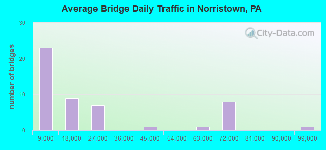
- 1,087,437Total average daily traffic
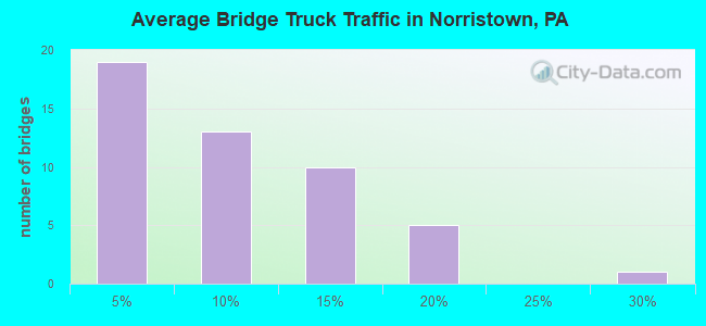
- 112,846Total average daily truck traffic
- National Bridge Inventory (NBI) Registered Bridges for Norristown
- No street view available for this location
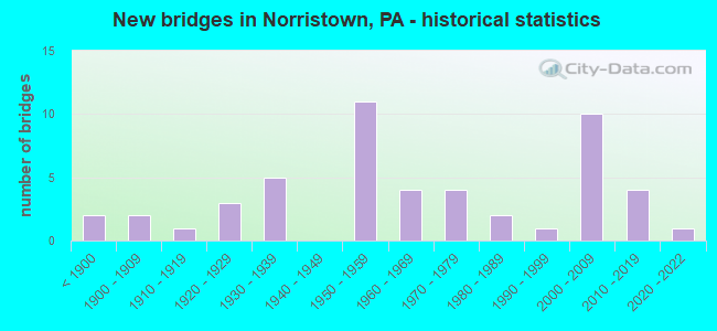
- New bridges - historical statistics
- 2Before 1900
- 21900-1909
- 11910-1919
- 31920-1929
- 51930-1939
- 111950-1959
- 41960-1969
- 41970-1979
- 21980-1989
- 11990-1999
- 102000-2009
- 42010-2019
- 12020-2022
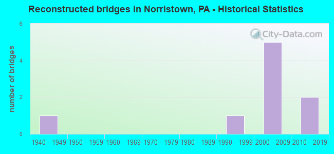
- Reconstructed bridges - Historical Statistics
- 11940-1949
- 01950-1959
- 01960-1969
- 01970-1979
- 01980-1989
- 11990-1999
- 52000-2009
- 22010-2019
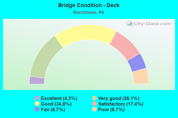
- Bridge Condition - Deck
- 4.3%Excellent
- 26.1%Very good
- 34.8%Good
- 17.4%Satisfactory
- 8.7%Fair
- 8.7%Poor
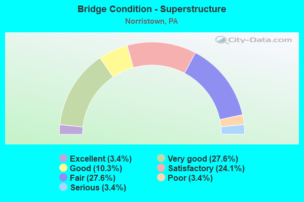
- Bridge Condition - Superstructure
- 3.4%Excellent
- 27.6%Very good
- 10.3%Good
- 24.1%Satisfactory
- 27.6%Fair
- 3.4%Poor
- 3.4%Serious
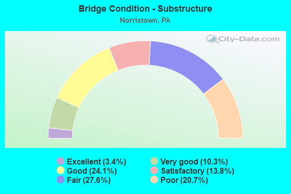
- Bridge Condition - Substructure
- 3.4%Excellent
- 10.3%Very good
- 24.1%Good
- 13.8%Satisfactory
- 27.6%Fair
- 20.7%Poor
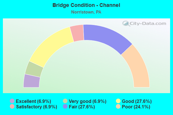
- Bridge Condition - Channel
- 6.9%Excellent
- 6.9%Very good
- 27.6%Good
- 6.9%Satisfactory
- 27.6%Fair
- 24.1%Poor
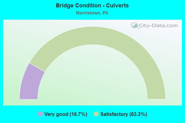
- Bridge Condition - Culverts
- 16.7%Very good
- 83.3%Satisfactory
Find on map >> Show street view
Structure Number: 27335, Location: N-TN,B-PT. 28K09/3367E3 (Lat: 40.110094, Lng: -75.344353), Route carried "on" structure: US 202, Year Built: 1993, Status: Open, Structure Length: 26.37m (86.52ft), Average Daily Traffic: 19,563 (year 2020), Truck Traffic: 6%, Average Future Daily Traffic: 20,345 (year 2032), Design Load: HS 25 or greater, Features Intersected: SCHUYLKILL RIVER, Facility Carried by Structure: DEKALB STREET
Minimum Vertical Clearance: 30+ m (98+ ft), Kilometerpoint: 6.077, Lanes on structure: 4, Base Highway Network: Yes, Owner: State Highway Agency, Approaching Roadway Width: 15.2m (49.9ft), Material/Design: Prestressed concrete continuous, Design/Construction: Stringer/Multi-beam, Number Of Spans In Main Unit: 7, Length of Maximum Span: 37.2m (122.0ft), Curb or Sidewalk Widths: Left: 1.9m (6.2ft), Right: 1.9m (6.2ft), Curb-To-Curb Width: 15.2m (49.9ft), Out-to-Out Width: 20.0m (65.6ft)
Condition: Deck: Good, Superstructure: Satisfactory, Substructure: Good, Channel: Fair, Inventory Rating: 48.1 metric tons, Method Used To Determine Inventory Rating: Load Factor (LF), Structural Evaluation: Equal to present minimum criteria, Deck Geometry: High priority of corrective action, Waterway Adequacy: Equal to present desirable criteria, Approach Roadway Alignment: Better than present minimum criteria, Length Of Structure Improvement: 24.60m (80.71ft), Designated Inspection Frequency: Every 24 months, Inspection Date: September 2021, Deck Structure Type: Concrete Cast-file-Place, Wearing Surface/Protective System: Wearing Surface: Monolithic Concrete, Deck Protection: Epoxy Coated Reinforcing
Find on map >> Show street view
Structure Number: 27685, Location: NORTH NORRISTOWN 29C01 (Lat: 40.157550, Lng: -75.323311), Route carried "on" structure: State highway , Year Built: 1933, Year Reconstructed: 2018, Status: Open, Structure Length: 2.01m (6.59ft), Average Daily Traffic: 9,871 (year 2022), Truck Traffic: 4%, Average Future Daily Traffic: 11,437 (year 2035), Design Load: HS 20, Features Intersected: STONY CREEK / 3255-J5, Facility Carried by Structure: TOWNSHIP LINE ROAD
Minimum Vertical Clearance: 30+ m (98+ ft), Kilometerpoint: 7.046, Lanes on structure: 2, Owner: State Highway Agency, Approaching Roadway Width: 8.5m (27.9ft), Skew: 2 degrees, Material/Design: Prestressed concrete continuous, Design/Construction: Box Beam or Girders - Single/Spread, Number Of Spans In Main Unit: 2, Length of Maximum Span: 9.8m (32.2ft), Curb-To-Curb Width: 8.5m (27.9ft), Out-to-Out Width: 9.4m (30.8ft)
Condition: Deck: Very good, Superstructure: Very good, Substructure: Fair, Channel: Poor, Operating Rating: 88.0 metric tons, Method Used To Determine Operating Rating: Assigned ratings based on Load and Resistance Factor Design (LRFD) reported in metric tons, Inventory Rating: 39.9 metric tons, Method Used To Determine Inventory Rating: Assigned ratings based on Load and Resistance Factor Design (LRFD) reported in metric tons, Structural Evaluation: Somewhat better than minimum adequacy, Deck Geometry: High priority of replacement, Waterway Adequacy: Equal to present minimum criteria, Approach Roadway Alignment: Equal to present desirable criteria, Length Of Structure Improvement: 2.70m (8.86ft), Designated Inspection Frequency: Every 24 months, Inspection Date: December 2020, Bridge Improvement Cost: $71,000, Roadway Improvement Cost: $209,000, Total Project Cost: $959,000, Deck Structure Type: Concrete Cast-file-Place, Wearing Surface/Protective System: Wearing Surface: Monolithic Concrete, Deck Protection: Epoxy Coated Reinforcing
Find on map >> Show street view
Structure Number: 27702, Location: NEAR LR178 3367-F2 (Lat: 40.114197, Lng: -75.338700), Route carried "on" structure: City street , Year Built: 1931, Status: Open, Structure Length: 0.79m (2.59ft), Average Daily Traffic: 6,882 (year 2014), Truck Traffic: 2%, Average Future Daily Traffic: 7,293 (year 2032), Design Load: H 20, Features Intersected: SAW MILL RUN CREEK, Facility Carried by Structure: AIRY ST
Minimum Vertical Clearance: 30+ m (98+ ft), Kilometerpoint: 0.000, Lanes on structure: 2, Owner: City or Municipal Highway Agency, Approaching Roadway Width: 11.0m (36.1ft), Material/Design: Concrete, Design/Construction: Culvert, Number Of Spans In Main Unit: 1, Length of Maximum Span: 7.3m (24.0ft), Curb or Sidewalk Widths: Left: 2.4m (7.9ft), Right: 1.5m (4.9ft)
Condition: Channel: Good, Culverts: Satisfactory, Operating Rating: 54.4 metric tons, Method Used To Determine Operating Rating: Field evaluation and documented engineering judgment, Inventory Rating: 32.7 metric tons, Method Used To Determine Inventory Rating: Field evaluation and documented engineering judgment, Structural Evaluation: Equal to present minimum criteria, Waterway Adequacy: Superior to present desirable criteria, Approach Roadway Alignment: Equal to present desirable criteria, Length Of Structure Improvement: 1.40m (4.59ft), Designated Inspection Frequency: Every 24 months, Inspection Date: October 2019
Find on map >> Show street view
Structure Number: 27703, Location: NORRISTOWN 3367-E02 (Lat: 40.117703, Lng: -75.347794), Route carried "on" structure: State highway , Year Built: 1977, Status: Open, Structure Length: 16.12m (52.89ft), Average Daily Traffic: 6,325 (year 2021), Truck Traffic: 7%, Average Future Daily Traffic: 7,361 (year 2032), Design Load: HS 20, Features Intersected: MARKLEY ST;SEPTA;CRK;RD, Facility Carried by Structure: WEST AIRY STREET
Minimum Vertical Clearance: 30+ m (98+ ft), Kilometerpoint: 3.140, Lanes on structure: 2, Lanes under structure: 6, Owner: State Highway Agency, Approaching Roadway Width: 11.0m (36.1ft), Material/Design: Steel, Design/Construction: Stringer/Multi-beam, Number Of Spans In Main Unit: 3, Number Of Approach Spans: 2, Length of Maximum Span: 44.2m (145.0ft), Curb or Sidewalk Widths: Left: 0.0m, Right: 1.5m (4.9ft), Curb-To-Curb Width: 11.0m (36.1ft), Out-to-Out Width: 12.2m (40.0ft)
Condition: Deck: Satisfactory, Superstructure: Satisfactory, Substructure: Poor, Channel: Good, Operating Rating: 74.4 metric tons, Method Used To Determine Operating Rating: Load Factor (LF), Inventory Rating: 44.5 metric tons, Method Used To Determine Inventory Rating: Load Factor (LF), Structural Evaluation: Meets minimum limits, Deck Geometry: Equal to present minimum criteria, Underclear: High priority of corrective action, Waterway Adequacy: Superior to present desirable criteria, Approach Roadway Alignment: Better than present minimum criteria, Length Of Structure Improvement: 16.90m (55.45ft), Designated Inspection Frequency: Every 24 months, Inspection Date: October 2019, Bridge Improvement Cost: $70,000, Roadway Improvement Cost: $207,000, Total Project Cost: $948,000, Deck Structure Type: Concrete Cast-file-Place, Wearing Surface/Protective System: Wearing Surface: Monolithic Concrete, Deck Protection: Galvanized Reinforcing
Find on map >> Show street view
Structure Number: 27723, Location: NEAR NORRISTOWN 29C06 (Lat: 40.126319, Lng: -75.319253), Route carried "on" structure: State highway , Year Built: 1924, Year Reconstructed: 2019, Status: Open, Structure Length: 0.85m (2.79ft), Average Daily Traffic: 6,940 (year 2022), Truck Traffic: 5%, Average Future Daily Traffic: 14,541 (year 2032), Design Load: HL 93, Features Intersected: BR SAW MILL RUN/3255-J10, Facility Carried by Structure: EAST JOHNSON HWY.
Minimum Vertical Clearance: 30+ m (98+ ft), Kilometerpoint: 2.910, Lanes on structure: 2, Owner: State Highway Agency, Approaching Roadway Width: 12.2m (40.0ft), Skew: 1 degrees, Material/Design: Prestressed concrete, Design/Construction: Box Beam or Girders - Single/Spread, Number Of Spans In Main Unit: 1, Length of Maximum Span: 8.2m (26.9ft), Curb or Sidewalk Widths: Left: 1.7m (5.6ft), Right: 1.8m (5.9ft), Curb-To-Curb Width: 12.2m (40.0ft), Out-to-Out Width: 16.8m (55.1ft)
Condition: Deck: Very good, Superstructure: Very good, Substructure: Good, Channel: Good, Operating Rating: 45.7 metric tons, Method Used To Determine Operating Rating: Assigned ratings based on Load and Resistance Factor Design (LRFD) reported by rating factor (RF) using HL93 loadings, Inventory Rating: 35.3 metric tons, Method Used To Determine Inventory Rating: Assigned ratings based on Load and Resistance Factor Design (LRFD) reported by rating factor (RF) using HL93 loadings, Structural Evaluation: Better than present minimum criteria, Deck Geometry: Somewhat better than minimum adequacy, Waterway Adequacy: Better than present minimum criteria, Approach Roadway Alignment: Equal to present desirable criteria, Designated Inspection Frequency: Every 24 months, Inspection Date: September 2021, Deck Structure Type: Concrete Cast-file-Place, Wearing Surface/Protective System: Wearing Surface: Monolithic Concrete, Deck Protection: Epoxy Coated Reinforcing
Find on map >> Show street view
Structure Number: 27726, Location: DANNEHOWER BRIDGE 28J09 (Lat: 40.109831, Lng: -75.350658), Route carried "on" structure: US 202, Year Built: 1968, Status: Open, Structure Length: 80.56m (264.30ft), Average Daily Traffic: 20,603 (year 2020), Truck Traffic: 8%, Average Future Daily Traffic: 35,336 (year 2032), Design Load: HS 20, Features Intersected: SCHUYLKILL RIVER, NSRC
Minimum Vertical Clearance: 30+ m (98+ ft), Kilometerpoint: 1.072, Lanes on structure: 2, Lanes under structure: 4, Base Highway Network: Yes, Owner: State Highway Agency, Approaching Roadway Width: 21.9m (71.9ft), Skew: 39 degrees, Material/Design: Steel continuous, Design/Construction: Girder and Floorbeam System, Number Of Spans In Main Unit: 11, Number Of Approach Spans: 11, Length of Maximum Span: 61.0m (200.1ft), Curb-To-Curb Width: 18.6m (61.0ft), Out-to-Out Width: 20.7m (67.9ft)
Condition: Deck: Satisfactory, Superstructure: Fair, Substructure: Fair, Channel: Fair, Operating Rating: 56.2 metric tons, Method Used To Determine Operating Rating: Load Factor (LF), Inventory Rating: 33.6 metric tons, Method Used To Determine Inventory Rating: Load Factor (LF), Structural Evaluation: Somewhat better than minimum adequacy, Deck Geometry: Superior to present desirable criteria, Underclear: Meets minimum limits, Waterway Adequacy: Superior to present desirable criteria, Approach Roadway Alignment: Better than present minimum criteria, Length Of Structure Improvement: 81.80m (268.37ft), Designated Inspection Frequency: Every 24 months, Critical Feature Inspection Frequency: Every 24 months, Underwater Inspection Frequency: Every 60 months, Inspection Date: Febuary 2020, Critical Feature Inspection Date: Febuary 2020, Underwater Inspection Date: December 2020, Bridge Improvement Cost: $803,000, Roadway Improvement Cost: $2,366,000, Total Project Cost: $10,844,000, Deck Structure Type: Concrete Cast-file-Place, Wearing Surface/Protective System: Wearing Surface: Latex Concrete
Find on map >> Show street view
Structure Number: 27968, Location: .4 Mi N US-202 3255-E10 (Lat: 40.127386, Lng: -75.345119), Route carried "on" structure: City street , Year Built: 1923, Year Reconstructed: 1940, Status: Posted for load, Structure Length: 2.59m (8.50ft), Average Daily Traffic: 17,741 (year 2019), Truck Traffic: 18%, Average Future Daily Traffic: 15,655 (year 2018), Features Intersected: STONY CREEK, Facility Carried by Structure: STERIGERE STREET
Minimum Vertical Clearance: 30+ m (98+ ft), Kilometerpoint: 0.000, Lanes on structure: 2, Owner: County Highway Agency, Approaching Roadway Width: 11.0m (36.1ft), Material/Design: Concrete, Design/Construction: Tee Beam, Number Of Spans In Main Unit: 3, Length of Maximum Span: 7.6m (24.9ft), Curb or Sidewalk Widths: Left: 1.5m (4.9ft), Right: 1.5m (4.9ft), Curb-To-Curb Width: 11.0m (36.1ft), Out-to-Out Width: 11.3m (37.1ft)
Condition: Deck: Poor, Superstructure: Poor, Substructure: Poor, Channel: Poor, Operating Rating: 30.8 metric tons, Method Used To Determine Operating Rating: Load Factor (LF), Inventory Rating: 18.1 metric tons, Method Used To Determine Inventory Rating: Load Factor (LF), Structural Evaluation: Meets minimum limits, Deck Geometry: Meets minimum limits, Waterway Adequacy: Better than present minimum criteria, Approach Roadway Alignment: Equal to present desirable criteria, Bridge Posting: Required (Relationship of Operating Rating to Maximum Legal Load: 10.0 - 19.9% below), Length Of Structure Improvement: 3.00m (9.84ft), Designated Inspection Frequency: Every 24 months, Other Special Inspection Frequency: Every 12 months, Inspection Date: June 2020, Other Special Inspection Date: June 2021, Bridge Improvement Cost: $23,000, Roadway Improvement Cost: $67,000, Total Project Cost: $308,000, Deck Structure Type: Concrete Cast-file-Place, Wearing Surface/Protective System: Wearing Surface: Bituminous
Find on map >> Show street view
Structure Number: 28036, Location: 0.67 MI N OF PLYMOUTH RD (Lat: 40.130147, Lng: -75.308664), Route carried "on" structure: City street , Year Built: 2004, Status: Open, Structure Length: 1.55m (5.09ft), Average Daily Traffic: 5,400 (year 2017), Truck Traffic: 1%, Average Future Daily Traffic: 6,000 (year 2037), Design Load: HS 20, Features Intersected: SAW MILL CREEK 3256-A10, Facility Carried by Structure: BELVOIR ROAD
Minimum Vertical Clearance: 30+ m (98+ ft), Kilometerpoint: 0.000, Lanes on structure: 2, Owner: Town or Township Highway Agency, Maintenance Responsibility: County Highway Agency, Approaching Roadway Width: 11.6m (38.1ft), Material/Design: Prestressed concrete, Design/Construction: Box Beam or Girders - Multiple, Number Of Spans In Main Unit: 1, Length of Maximum Span: 15.2m (49.9ft), Curb or Sidewalk Widths: Left: 0.2m (0.7ft), Right: 2.4m (7.9ft), Curb-To-Curb Width: 11.5m (37.7ft), Out-to-Out Width: 14.8m (48.6ft)
Condition: Deck: Good, Superstructure: Good, Substructure: Good, Channel: Satisfactory, Inventory Rating: 65.3 metric tons, Method Used To Determine Inventory Rating: Load Factor (LF), Structural Evaluation: Better than present minimum criteria, Deck Geometry: Meets minimum limits, Waterway Adequacy: Equal to present minimum criteria, Approach Roadway Alignment: Equal to present desirable criteria, Length Of Structure Improvement: 0.90m (2.95ft), Designated Inspection Frequency: Every 24 months, Inspection Date: May 2020, Bridge Improvement Cost: $9,000, Roadway Improvement Cost: $60,000, Total Project Cost: $120,000, Deck Structure Type: Concrete Cast-file-Place, Wearing Surface/Protective System: Wearing Surface: Monolithic Concrete, Deck Protection: Epoxy Coated Reinforcing
Find on map >> Show street view
Structure Number: 28152, Location: SOUTH OF NORRISTOWN (Lat: 40.096889, Lng: -75.341889), Route carried "on" structure: Interstate 276, Year Built: 1954, Year Reconstructed: 2008, Status: Open, Structure Length: 0.73m (2.40ft), Average Daily Traffic: 65,138 (year 2004), Truck Traffic: 12%, Average Future Daily Traffic: 98,418 (year 2030), Design Load: HS 20, Features Intersected: TRIB. DIAMOND RUN
Minimum Vertical Clearance: 30+ m (98+ ft), Kilometerpoint: 0.000, Lanes on structure: 6, Base Highway Network: Yes, Toll: On toll road, Owner: State Toll Authority, Approaching Roadway Width: 33.5m (109.9ft), Skew: 34 degrees, Material/Design: Concrete, Design/Construction: Culvert, Number Of Spans In Main Unit: 1, Length of Maximum Span: 4.9m (16.1ft)
Condition: Channel: Good, Culverts: Satisfactory, Operating Rating: 59.0 metric tons, Method Used To Determine Operating Rating: Load Factor (LF), Inventory Rating: 35.4 metric tons, Method Used To Determine Inventory Rating: Load Factor (LF), Structural Evaluation: Equal to present minimum criteria, Waterway Adequacy: Superior to present desirable criteria, Approach Roadway Alignment: Equal to present desirable criteria, Length Of Structure Improvement: 1.40m (4.59ft), Designated Inspection Frequency: Every 24 months, Inspection Date: May 2020, Bridge Improvement Cost: $23,000, Roadway Improvement Cost: $68,000, Total Project Cost: $312,000
Find on map >> Show street view
Structure Number: 28155, Location: EAST OF BRIDGEPORT (Lat: 40.102850, Lng: -75.325903), Route carried "on" structure: Interstate 276, Year Built: 1954, Year Reconstructed: 2000, Status: Open, Structure Length: 37.58m (123.29ft), Average Daily Traffic: 65,138 (year 2004), Truck Traffic: 12%, Average Future Daily Traffic: 102,790 (year 2030), Design Load: HS 25 or greater, Features Intersected: SR0023,SR3025,NSRR,SEPTA
Minimum Vertical Clearance: 30+ m (98+ ft), Kilometerpoint: 0.000, Lanes on structure: 2, Lanes under structure: 8, Base Highway Network: Yes, Toll: On toll road, Owner: State Toll Authority, Approaching Roadway Width: 14.9m (48.9ft), Skew: 10 degrees, Material/Design: Steel continuous, Design/Construction: Girder and Floorbeam System, Number Of Spans In Main Unit: 11, Length of Maximum Span: 39.6m (129.9ft), Curb or Sidewalk Widths: Left: 0.2m (0.7ft), Right: 0.2m (0.7ft), Curb-To-Curb Width: 15.1m (49.5ft), Out-to-Out Width: 16.1m (52.8ft)
Condition: Deck: Good, Superstructure: Satisfactory, Substructure: Satisfactory, Channel: Good, Operating Rating: 52.6 metric tons, Method Used To Determine Operating Rating: Load Factor (LF), Inventory Rating: 30.8 metric tons, Method Used To Determine Inventory Rating: Load Factor (LF), Structural Evaluation: Equal to present minimum criteria, Deck Geometry: Superior to present desirable criteria, Underclear: High priority of corrective action, Waterway Adequacy: Superior to present desirable criteria, Approach Roadway Alignment: Equal to present desirable criteria, Length Of Structure Improvement: 37.40m (122.70ft), Designated Inspection Frequency: Every 24 months, Critical Feature Inspection Frequency: Every 24 months, Underwater Inspection Frequency: Every 60 months, Inspection Date: August 2019, Critical Feature Inspection Date: August 2019, Underwater Inspection Date: October 2018, Bridge Improvement Cost: $443,000, Roadway Improvement Cost: $1,305,000, Total Project Cost: $5,981,000, Deck Structure Type: Corrugated Steel, Wearing Surface/Protective System: Wearing Surface: Latex Concrete, Deck Protection: Epoxy Coated Reinforcing
Find on map >> Show street view
Structure Number: 28157, Location: SOUTHEAST OF NORRISTOWN (Lat: 40.105719, Lng: -75.314500), Route carried "on" structure: Alternate US 422, Year Built: 1954, Status: Open, Structure Length: 6.43m (21.10ft), Average Daily Traffic: 200 (year 1992), Truck Traffic: 3%, Average Future Daily Traffic: 315 (year 2030), Design Load: HS 20, Features Intersected: PA TPK (I-276), Facility Carried by Structure: RIDGE PIKE
Minimum Vertical Clearance: 30+ m (98+ ft), Kilometerpoint: 0.000, Lanes on structure: 4, Lanes under structure: 4, Base Highway Network: Yes, Owner: State Toll Authority, Approaching Roadway Width: 14.9m (48.9ft), Skew: 3 degrees, Material/Design: Steel continuous, Design/Construction: Stringer/Multi-beam, Number Of Spans In Main Unit: 3, Length of Maximum Span: 34.7m (113.8ft), Curb or Sidewalk Widths: Left: 1.5m (4.9ft), Right: 1.5m (4.9ft), Curb-To-Curb Width: 14.9m (48.9ft), Out-to-Out Width: 18.8m (61.7ft)
Condition: Deck: Poor, Superstructure: Fair, Substructure: Fair, Operating Rating: 39.0 metric tons, Method Used To Determine Operating Rating: Load and Resistance Factor (LRFR), Inventory Rating: 29.9 metric tons, Method Used To Determine Inventory Rating: Load and Resistance Factor (LRFR), Structural Evaluation: Somewhat better than minimum adequacy, Deck Geometry: High priority of replacement, Underclear: High priority of corrective action, Approach Roadway Alignment: Equal to present minimum criteria, Length Of Structure Improvement: 7.20m (23.62ft), Designated Inspection Frequency: Every 24 months, Inspection Date: May 2020, Bridge Improvement Cost: $86,000, Roadway Improvement Cost: $253,000, Total Project Cost: $1,160,000, Deck Structure Type: Concrete Cast-file-Place, Wearing Surface/Protective System: Wearing Surface: Bituminous
Find on map >> Show street view
Structure Number: 28159, Location: WEST OF NORRISTOWN INTG (Lat: 40.107769, Lng: -75.303167), Route carried "on" structure: Interstate 276, Year Built: 2006, Status: Open, Structure Length: 1.16m (3.81ft), Average Daily Traffic: 55,966 (year 2001), Truck Traffic: 14%, Average Future Daily Traffic: 88,684 (year 2030), Design Load: HS 20, Features Intersected: T-694
Minimum Vertical Clearance: 30+ m (98+ ft), Kilometerpoint: 0.000, Lanes on structure: 4, Lanes under structure: 2, Base Highway Network: Yes, Toll: On toll road, Owner: State Toll Authority, Approaching Roadway Width: 31.1m (102.0ft), Skew: 33 degrees, Material/Design: Prestressed concrete, Design/Construction: Box Beam or Girders - Single/Spread, Number Of Spans In Main Unit: 1, Length of Maximum Span: 10.7m (35.1ft), Curb or Sidewalk Widths: Left: 0.2m (0.7ft), Right: 0.2m (0.7ft), Curb-To-Curb Width: 31.1m (102.0ft), Out-to-Out Width: 33.5m (109.9ft)
Condition: Deck: Good, Superstructure: Satisfactory, Substructure: Satisfactory, Operating Rating: 96.2 metric tons, Method Used To Determine Operating Rating: Load Factor (LF), Inventory Rating: 41.7 metric tons, Method Used To Determine Inventory Rating: Load Factor (LF), Structural Evaluation: Equal to present minimum criteria, Deck Geometry: Superior to present desirable criteria, Underclear: Equal to present minimum criteria, Approach Roadway Alignment: Equal to present desirable criteria, Length Of Structure Improvement: 1.80m (5.91ft), Designated Inspection Frequency: Every 48 months, Inspection Date: May 2018, Bridge Improvement Cost: $19,000, Roadway Improvement Cost: $56,000, Total Project Cost: $257,000, Deck Structure Type: Concrete Cast-file-Place, Wearing Surface/Protective System: Wearing Surface: Monolithic Concrete
Find on map >> Show street view
Structure Number: 28161, Location: NORRISTOWN INTERCHANGE (Lat: 40.101667, Lng: -75.284444), Route carried "on" structure: Ramp Interstate 276, Year Built: 1954, Year Reconstructed: 1995, Status: Open, Structure Length: 7.83m (25.69ft), Average Daily Traffic: 43,330 (year 1993), Truck Traffic: 5%, Average Future Daily Traffic: 57,129 (year 2030), Design Load: HS 25 or greater, Features Intersected: PA TPK (I-276), Facility Carried by Structure: PA TPK RAMP AB
Minimum Vertical Clearance: 30+ m (98+ ft), Kilometerpoint: 0.000, Lanes on structure: 2, Lanes under structure: 7, Base Highway Network: Yes, Toll: On toll road, Owner: State Toll Authority, Approaching Roadway Width: 7.9m (25.9ft), Skew: 10 degrees, Material/Design: Steel continuous, Design/Construction: Stringer/Multi-beam, Number Of Spans In Main Unit: 3, Number Of Approach Spans: 2, Length of Maximum Span: 37.8m (124.0ft), Curb or Sidewalk Widths: Left: 0.2m (0.7ft), Right: 0.2m (0.7ft), Curb-To-Curb Width: 7.9m (25.9ft), Out-to-Out Width: 18.0m (59.1ft)
Condition: Deck: Good, Superstructure: Very good, Substructure: Satisfactory, Operating Rating: 79.8 metric tons, Method Used To Determine Operating Rating: Load Factor (LF), Inventory Rating: 48.1 metric tons, Method Used To Determine Inventory Rating: Load Factor (LF), Structural Evaluation: Equal to present minimum criteria, Deck Geometry: High priority of replacement, Underclear: High priority of replacement, Approach Roadway Alignment: Equal to present minimum criteria, Length Of Structure Improvement: 5.90m (19.36ft), Designated Inspection Frequency: Every 24 months, Inspection Date: May 2020, Bridge Improvement Cost: $219,000, Roadway Improvement Cost: $646,000, Total Project Cost: $2,960,000, Deck Structure Type: Concrete Cast-file-Place, Wearing Surface/Protective System: Wearing Surface: Latex Concrete, Deck Protection: Epoxy Coated Reinforcing
Find on map >> Show street view
Structure Number: 28213, Location: .1 MI. N. MAIN ST 3367E02 (Lat: 40.118142, Lng: -75.347442), Route carried "on" structure: US 202, Year Built: 1968, Status: Closed, Structure Length: 3.63m (11.91ft), Average Daily Traffic: 13,461 (year 2020), Truck Traffic: 5%, Average Future Daily Traffic: 18,071 (year 2030), Design Load: HS 20, Features Intersected: STONY CREEK, Facility Carried by Structure: MARKLEY STREET(SB)
Minimum Vertical Clearance: 30+ m (98+ ft), Kilometerpoint: 1.951, Lanes on structure: 2, Base Highway Network: Yes, Owner: State Highway Agency, Approaching Roadway Width: 7.9m (25.9ft), Skew: 4 degrees, Material/Design: Steel, Design/Construction: Stringer/Multi-beam, Number Of Spans In Main Unit: 1, Length of Maximum Span: 34.7m (113.8ft), Curb or Sidewalk Widths: Left: 0.5m (1.6ft), Right: 0.5m (1.6ft), Curb-To-Curb Width: 7.9m (25.9ft), Out-to-Out Width: 9.6m (31.5ft)
Condition: Deck: Satisfactory, Superstructure: Satisfactory, Substructure: Fair, Channel: Fair, Inventory Rating: 64.4 metric tons, Method Used To Determine Inventory Rating: Load Factor (LF), Structural Evaluation: Somewhat better than minimum adequacy, Waterway Adequacy: Better than present minimum criteria, Approach Roadway Alignment: Equal to present desirable criteria, Length Of Structure Improvement: 4.60m (15.09ft), Designated Inspection Frequency: Every 24 months, Inspection Date: June 2020, Bridge Improvement Cost: $10,000, Roadway Improvement Cost: $31,000, Total Project Cost: $140,000, Deck Structure Type: Steel plate, Wearing Surface/Protective System: Wearing Surface: Monolithic Concrete
Find on map >> Show street view
Structure Number: 28214, Location: 1600"SE.OF TR202N 3367-G2 (Lat: 40.118567, Lng: -75.331825), Route carried "on" structure: City street , Year Built: 1928, Status: Open, Structure Length: 0.79m (2.59ft), Average Daily Traffic: 4,000 (year 2015), Truck Traffic: 2%, Average Future Daily Traffic: 4,500 (year 2035), Design Load: HS 20, Features Intersected: SAWMILL RUN, Facility Carried by Structure: BASIN STREET
Minimum Vertical Clearance: 30+ m (98+ ft), Kilometerpoint: 0.000, Lanes on structure: 2, Owner: Town or Township Highway Agency, Approaching Roadway Width: 7.9m (25.9ft), Skew: 1 degrees, Material/Design: Concrete, Design/Construction: Tee Beam, Number Of Spans In Main Unit: 1, Length of Maximum Span: 7.0m (23.0ft), Curb or Sidewalk Widths: Left: 3.3m (10.8ft), Right: 3.3m (10.8ft), Curb-To-Curb Width: 7.9m (25.9ft), Out-to-Out Width: 14.6m (47.9ft)
Condition: Deck: Fair, Superstructure: Fair, Substructure: Poor, Channel: Poor, Operating Rating: 73.5 metric tons, Method Used To Determine Operating Rating: Load Factor (LF), Inventory Rating: 43.5 metric tons, Method Used To Determine Inventory Rating: Load Factor (LF), Structural Evaluation: Meets minimum limits, Deck Geometry: High priority of corrective action, Waterway Adequacy: Equal to present minimum criteria, Approach Roadway Alignment: Equal to present desirable criteria, Length Of Structure Improvement: 0.80m (2.62ft), Designated Inspection Frequency: Every 24 months, Inspection Date: October 2020, Bridge Improvement Cost: $6,000, Roadway Improvement Cost: $18,000, Total Project Cost: $82,000, Deck Structure Type: Concrete Cast-file-Place, Wearing Surface/Protective System: Wearing Surface: Bituminous
Find on map >> Show street view
Structure Number: 28215, Location: 1500' SE US-202N 3367-G2 (Lat: 40.116264, Lng: -75.334497), Route carried "on" structure: City street , Year Built: 1932, Status: Open, Structure Length: 0.61m (2.00ft), Average Daily Traffic: 5,600 (year 2015), Truck Traffic: 2%, Average Future Daily Traffic: 6,000 (year 2035), Features Intersected: SAW MILL RUN, Facility Carried by Structure: OAK STREET
Minimum Vertical Clearance: 30+ m (98+ ft), Kilometerpoint: 0.000, Lanes on structure: 2, Owner: Town or Township Highway Agency, Approaching Roadway Width: 7.9m (25.9ft), Material/Design: Masonry, Design/Construction: Arch - Deck, Number Of Spans In Main Unit: 1, Length of Maximum Span: 6.1m (20.0ft), Curb or Sidewalk Widths: Left: 3.4m (11.2ft), Right: 2.9m (9.5ft), Curb-To-Curb Width: 7.9m (25.9ft), Out-to-Out Width: 15.5m (50.9ft)
Condition: Superstructure: Fair, Substructure: Fair, Channel: Poor, Operating Rating: 56.2 metric tons, Method Used To Determine Operating Rating: Field evaluation and documented engineering judgment, Inventory Rating: 33.6 metric tons, Method Used To Determine Inventory Rating: Field evaluation and documented engineering judgment, Structural Evaluation: Somewhat better than minimum adequacy, Deck Geometry: High priority of replacement, Waterway Adequacy: Equal to present desirable criteria, Approach Roadway Alignment: Equal to present desirable criteria, Length Of Structure Improvement: 0.80m (2.62ft), Designated Inspection Frequency: Every 24 months, Underwater Inspection Frequency: Every 24 months, Inspection Date: April 2020, Underwater Inspection Date: May 2021, Bridge Improvement Cost: $13,000, Roadway Improvement Cost: $37,000, Total Project Cost: $171,000
Find on map >> Show street view
Structure Number: 28216, Location: 500FT W OF SR0202 3367-D2 (Lat: 40.117100, Lng: -75.349900), Route carried "on" structure: City street , Year Built: 1854, Year Reconstructed: 2014, Status: Open, Structure Length: 1.16m (3.81ft), Average Daily Traffic: 15,000 (year 2014), Truck Traffic: 1%, Average Future Daily Traffic: 17,500 (year 2034), Features Intersected: STONY CREEK, Facility Carried by Structure: MAIN STREET
Minimum Vertical Clearance: 30+ m (98+ ft), Kilometerpoint: 0.000, Lanes on structure: 4, Base Highway Network: Yes, Owner: Town or Township Highway Agency, Approaching Roadway Width: 15.2m (49.9ft), Material/Design: Masonry, Design/Construction: Arch - Deck, Number Of Spans In Main Unit: 1, Length of Maximum Span: 11.6m (38.1ft), Curb or Sidewalk Widths: Left: 3.1m (10.2ft), Right: 2.7m (8.9ft), Curb-To-Curb Width: 18.8m (61.7ft), Out-to-Out Width: 24.9m (81.7ft)
Condition: Superstructure: Good, Substructure: Good, Channel: Satisfactory, Operating Rating: 69.9 metric tons, Method Used To Determine Operating Rating: Field evaluation and documented engineering judgment, Inventory Rating: 41.7 metric tons, Method Used To Determine Inventory Rating: Field evaluation and documented engineering judgment, Structural Evaluation: Better than present minimum criteria, Deck Geometry: Equal to present minimum criteria, Waterway Adequacy: Superior to present desirable criteria, Approach Roadway Alignment: Equal to present desirable criteria, Length Of Structure Improvement: 1.50m (4.92ft), Designated Inspection Frequency: Every 24 months, Underwater Inspection Frequency: Every 60 months, Inspection Date: March 2021, Underwater Inspection Date: December 2020, Bridge Improvement Cost: $104,000, Roadway Improvement Cost: $307,000, Total Project Cost: $1,406,000
Find on map >> Show street view
Structure Number: 28217, Location: 200"SE.OF TR2025 3367-E2 (Lat: 40.118539, Lng: -75.345944), Route carried "on" structure: City street , Year Built: 1982, Status: Open, Structure Length: 3.23m (10.60ft), Average Daily Traffic: 12,000 (year 2014), Truck Traffic: 1%, Average Future Daily Traffic: 14,000 (year 2034), Design Load: HS 20, Features Intersected: STONY CREEK, Facility Carried by Structure: MARSHALL STREET
Minimum Vertical Clearance: 30+ m (98+ ft), Kilometerpoint: 0.000, Lanes on structure: 2, Owner: Town or Township Highway Agency, Approaching Roadway Width: 10.4m (34.1ft), Skew: 3 degrees, Material/Design: Steel, Design/Construction: Stringer/Multi-beam, Number Of Spans In Main Unit: 1, Length of Maximum Span: 30.8m (101.0ft), Curb or Sidewalk Widths: Left: 2.1m (6.9ft), Right: 2.1m (6.9ft), Curb-To-Curb Width: 10.4m (34.1ft), Out-to-Out Width: 15.2m (49.9ft)
Condition: Deck: Good, Superstructure: Satisfactory, Substructure: Fair, Channel: Fair, Operating Rating: 82.6 metric tons, Method Used To Determine Operating Rating: Load Factor (LF), Inventory Rating: 49.9 metric tons, Method Used To Determine Inventory Rating: Load Factor (LF), Structural Evaluation: Somewhat better than minimum adequacy, Deck Geometry: Meets minimum limits, Waterway Adequacy: Equal to present desirable criteria, Approach Roadway Alignment: Equal to present desirable criteria, Length Of Structure Improvement: 4.00m (13.12ft), Designated Inspection Frequency: Every 24 months, Inspection Date: October 2020, Deck Structure Type: Concrete Cast-file-Place, Wearing Surface/Protective System: Wearing Surface: Monolithic Concrete, Deck Protection: Epoxy Coated Reinforcing
Find on map >> Show street view
Structure Number: 28218, Location: 700 Ft SE US-202 3367-F2 (Lat: 40.115600, Lng: -75.338097), Route carried "on" structure: City street , Year Built: 1910, Status: Open, Structure Length: 0.76m (2.49ft), Average Daily Traffic: 3,300 (year 2009), Truck Traffic: 2%, Average Future Daily Traffic: 4,620 (year 2020), Features Intersected: SAW MILL RUN, Facility Carried by Structure: MARSHALL STREET
Minimum Vertical Clearance: 30+ m (98+ ft), Kilometerpoint: 0.000, Lanes on structure: 2, Owner: Town or Township Highway Agency, Approaching Roadway Width: 7.9m (25.9ft), Material/Design: Masonry, Design/Construction: Arch - Deck, Number Of Spans In Main Unit: 1, Length of Maximum Span: 7.3m (24.0ft), Curb or Sidewalk Widths: Left: 3.3m (10.8ft), Right: 3.3m (10.8ft), Curb-To-Curb Width: 7.9m (25.9ft), Out-to-Out Width: 15.4m (50.5ft)
Condition: Superstructure: Fair, Substructure: Fair, Channel: Fair, Operating Rating: 59.9 metric tons, Method Used To Determine Operating Rating: Field evaluation and documented engineering judgment, Inventory Rating: 35.4 metric tons, Method Used To Determine Inventory Rating: Field evaluation and documented engineering judgment, Structural Evaluation: Somewhat better than minimum adequacy, Deck Geometry: High priority of corrective action, Waterway Adequacy: Equal to present desirable criteria, Approach Roadway Alignment: Equal to present desirable criteria, Length Of Structure Improvement: 0.90m (2.95ft), Designated Inspection Frequency: Every 24 months, Inspection Date: March 2020, Bridge Improvement Cost: $7,000, Roadway Improvement Cost: $20,000, Total Project Cost: $91,000
Find on map >> Show street view
Structure Number: 2822, Location: 900 FT SE.TR 202N 3367F02 (Lat: 40.113300, Lng: -75.338800), Route carried "on" structure: City street 7413, Year Built: 1983, Status: Open, Structure Length: 0.79m (2.59ft), Average Daily Traffic: 6,000 (year 2011), Truck Traffic: 1%, Average Future Daily Traffic: 6,500 (year 2031), Design Load: HS 20, Features Intersected: SAWMILL RUN, Facility Carried by Structure: ARCH & PENN STREET
Minimum Vertical Clearance: 30+ m (98+ ft), Kilometerpoint: 0.000, Lanes on structure: 2, Owner: Town or Township Highway Agency, Approaching Roadway Width: 7.9m (25.9ft), Skew: 4 degrees, Material/Design: Concrete, Design/Construction: Culvert, Number Of Spans In Main Unit: 1, Length of Maximum Span: 7.9m (25.9ft)
Condition: Channel: Good, Culverts: Satisfactory, Operating Rating: 58.1 metric tons, Method Used To Determine Operating Rating: Load Factor (LF), Inventory Rating: 34.5 metric tons, Method Used To Determine Inventory Rating: Load Factor (LF), Structural Evaluation: Equal to present minimum criteria, Waterway Adequacy: Superior to present desirable criteria, Approach Roadway Alignment: Equal to present desirable criteria, Length Of Structure Improvement: 1.20m (3.94ft), Designated Inspection Frequency: Every 24 months, Inspection Date: April 2021
Find on map >> Show street view
Structure Number: 28221, Location: 1400 Ft S US-202 3367-F3 (Lat: 40.110506, Lng: -75.338350), Route carried "on" structure: City street , Year Built: 1931, Status: Open, Structure Length: 1.01m (3.31ft), Average Daily Traffic: 4,000 (year 2014), Truck Traffic: 2%, Average Future Daily Traffic: 5,150 (year 2034), Features Intersected: SAW MILL RUN, Facility Carried by Structure: WASHINGTON STREET
Minimum Vertical Clearance: 30+ m (98+ ft), Kilometerpoint: 0.000, Lanes on structure: 2, Owner: Town or Township Highway Agency, Approaching Roadway Width: 6.1m (20.0ft), Skew: 2 degrees, Material/Design: Concrete, Design/Construction: Tee Beam, Number Of Spans In Main Unit: 1, Length of Maximum Span: 9.8m (32.2ft), Curb or Sidewalk Widths: Left: 0.2m (0.7ft), Right: 2.7m (8.9ft), Curb-To-Curb Width: 6.1m (20.0ft), Out-to-Out Width: 9.1m (29.9ft)
Condition: Deck: Satisfactory, Superstructure: Satisfactory, Substructure: Poor, Channel: Poor, Operating Rating: 54.4 metric tons, Method Used To Determine Operating Rating: Field evaluation and documented engineering judgment, Inventory Rating: 32.7 metric tons, Method Used To Determine Inventory Rating: Field evaluation and documented engineering judgment, Structural Evaluation: Meets minimum limits, Deck Geometry: High priority of replacement, Waterway Adequacy: Superior to present desirable criteria, Approach Roadway Alignment: Equal to present desirable criteria, Length Of Structure Improvement: 0.90m (2.95ft), Designated Inspection Frequency: Every 24 months, Inspection Date: October 2020, Deck Structure Type: Concrete Cast-file-Place, Wearing Surface/Protective System: Wearing Surface: Bituminous
Find on map >> Show street view
Structure Number: 28222, Location: 900' SE of 202NB 3367-F2 (Lat: 40.115739, Lng: -75.337236), Route carried "on" structure: City street , Year Built: 1900, Status: Open, Structure Length: 0.76m (2.49ft), Average Daily Traffic: 5,600 (year 2015), Truck Traffic: 2%, Average Future Daily Traffic: 6,000 (year 2035), Features Intersected: SAW MILL RUN, Facility Carried by Structure: ARCH STREET
Minimum Vertical Clearance: 30+ m (98+ ft), Kilometerpoint: 0.000, Lanes on structure: 2, Owner: Town or Township Highway Agency, Approaching Roadway Width: 7.9m (25.9ft), Material/Design: Masonry, Design/Construction: Arch - Deck, Number Of Spans In Main Unit: 1, Length of Maximum Span: 7.3m (24.0ft), Curb or Sidewalk Widths: Left: 3.3m (10.8ft), Right: 3.3m (10.8ft), Curb-To-Curb Width: 7.9m (25.9ft), Out-to-Out Width: 15.4m (50.5ft)
Condition: Superstructure: Fair, Substructure: Fair, Channel: Fair, Operating Rating: 56.2 metric tons, Method Used To Determine Operating Rating: Field evaluation and documented engineering judgment, Inventory Rating: 32.7 metric tons, Method Used To Determine Inventory Rating: Field evaluation and documented engineering judgment, Structural Evaluation: Somewhat better than minimum adequacy, Deck Geometry: High priority of replacement, Waterway Adequacy: Equal to present desirable criteria, Approach Roadway Alignment: Equal to present desirable criteria, Length Of Structure Improvement: 0.90m (2.95ft), Designated Inspection Frequency: Every 24 months, Inspection Date: April 2020, Bridge Improvement Cost: $15,000, Roadway Improvement Cost: $44,000, Total Project Cost: $203,000
Find on map >> Show street view
Structure Number: 28223, Location: 1600 FT SE.TR202N 3367-H1 (Lat: 40.119956, Lng: -75.329842), Route carried "on" structure: City street , Year Built: 1932, Status: Open, Structure Length: 0.73m (2.40ft), Average Daily Traffic: 8,260 (year 2018), Truck Traffic: 1%, Average Future Daily Traffic: 10,000 (year 2038), Design Load: HS 20, Features Intersected: SAWMILL RUN, Facility Carried by Structure: FORNANCE STREET
Minimum Vertical Clearance: 30+ m (98+ ft), Kilometerpoint: 0.000, Lanes on structure: 2, Owner: Town or Township Highway Agency, Approaching Roadway Width: 10.4m (34.1ft), Material/Design: Concrete, Design/Construction: Slab, Number Of Spans In Main Unit: 1, Length of Maximum Span: 6.7m (22.0ft), Curb or Sidewalk Widths: Left: 1.5m (4.9ft), Right: 1.5m (4.9ft), Curb-To-Curb Width: 9.1m (29.9ft), Out-to-Out Width: 9.6m (31.5ft)
Condition: Deck: Fair, Superstructure: Fair, Substructure: Poor, Channel: Poor, Operating Rating: 78.0 metric tons, Method Used To Determine Operating Rating: Load Factor (LF), Inventory Rating: 47.2 metric tons, Method Used To Determine Inventory Rating: Load Factor (LF), Structural Evaluation: Meets minimum limits, Deck Geometry: High priority of corrective action, Waterway Adequacy: Equal to present minimum criteria, Approach Roadway Alignment: Equal to present desirable criteria, Length Of Structure Improvement: 0.70m (2.30ft), Designated Inspection Frequency: Every 24 months, Inspection Date: October 2020, Bridge Improvement Cost: $7,000, Roadway Improvement Cost: $50,000, Total Project Cost: $92,000, Deck Structure Type: Concrete Cast-file-Place, Wearing Surface/Protective System: Wearing Surface: Bituminous
Find on map >> Show street view
Structure Number: 28226, Location: 0.4 Mi W US-202 N 3367-E1 (Lat: 40.122028, Lng: -75.343464), Route carried "on" structure: US 202, Year Built: 1878, Year Reconstructed: 2021, Status: Open, Structure Length: 2.10m (6.89ft), Average Daily Traffic: 20,375 (year 2022), Truck Traffic: 3%, Average Future Daily Traffic: 21,747 (year 2030), Features Intersected: STONY CREEK, Facility Carried by Structure: MARKLEY/ELM STREET
Minimum Vertical Clearance: 30+ m (98+ ft), Kilometerpoint: 2.454, Lanes on structure: 4, Base Highway Network: Yes, Owner: State Highway Agency, Approaching Roadway Width: 11.0m (36.1ft), Skew: 5 degrees, Material/Design: Masonry, Design/Construction: Arch - Deck, Number Of Spans In Main Unit: 2, Length of Maximum Span: 7.6m (24.9ft), Curb or Sidewalk Widths: Left: 6.7m (22.0ft), Right: 6.5m (21.3ft), Curb-To-Curb Width: 11.0m (36.1ft), Out-to-Out Width: 37.3m (122.4ft)
Condition: Superstructure: Serious, Substructure: Poor, Channel: Poor, Operating Rating: 48.1 metric tons, Method Used To Determine Operating Rating: Field evaluation and documented engineering judgment, Inventory Rating: 28.1 metric tons, Method Used To Determine Inventory Rating: Field evaluation and documented engineering judgment, Structural Evaluation: High priority of corrective action, Deck Geometry: High priority of replacement, Waterway Adequacy: Superior to present desirable criteria, Approach Roadway Alignment: Equal to present desirable criteria, Length Of Structure Improvement: 2.80m (9.19ft), Designated Inspection Frequency: Every 24 months, Other Special Inspection Frequency: Every 6 months, Inspection Date: March 2020, Other Special Inspection Date: September 2021, Bridge Improvement Cost: $172,000, Roadway Improvement Cost: $505,000, Total Project Cost: $2,316,000
Find on map >> Show street view
Structure Number: 28227, Location: .6 Mi SE US202 3367-F3 (Lat: 40.112472, Lng: -75.338881), Route carried "on" structure: City street , Year Built: 1900, Status: Open, Structure Length: 0.64m (2.10ft), Average Daily Traffic: 15,408 (year 2014), Truck Traffic: 1%, Average Future Daily Traffic: 18,500 (year 2034), Features Intersected: SAW MILL RUN, Facility Carried by Structure: MAIN STREET
Minimum Vertical Clearance: 30+ m (98+ ft), Kilometerpoint: 0.000, Lanes on structure: 3, Base Highway Network: Yes, Owner: Town or Township Highway Agency, Approaching Roadway Width: 14.3m (46.9ft), Material/Design: Masonry, Design/Construction: Arch - Deck, Number Of Spans In Main Unit: 1, Length of Maximum Span: 6.4m (21.0ft), Curb or Sidewalk Widths: Left: 4.6m (15.1ft), Right: 4.4m (14.4ft), Curb-To-Curb Width: 14.5m (47.6ft), Out-to-Out Width: 23.7m (77.8ft)
Condition: Superstructure: Fair, Substructure: Satisfactory, Channel: Good, Operating Rating: 57.2 metric tons, Method Used To Determine Operating Rating: Field evaluation and documented engineering judgment, Inventory Rating: 34.5 metric tons, Method Used To Determine Inventory Rating: Field evaluation and documented engineering judgment, Structural Evaluation: Somewhat better than minimum adequacy, Deck Geometry: Somewhat better than minimum adequacy, Waterway Adequacy: Superior to present desirable criteria, Approach Roadway Alignment: Equal to present desirable criteria, Length Of Structure Improvement: 1.20m (3.94ft), Designated Inspection Frequency: Every 24 months, Inspection Date: April 2020, Bridge Improvement Cost: $31,000, Roadway Improvement Cost: $90,000, Total Project Cost: $413,000
Find on map >> Show street view
Structure Number: 28243, Location: NEAR CENTER SQUARE (Lat: 40.163333, Lng: -75.303333), Route carried "on" structure: Interstate 476, Year Built: 1955, Year Reconstructed: 2012, Status: Open, Structure Length: 0.88m (2.89ft), Average Daily Traffic: 65,329 (year 2004), Truck Traffic: 16%, Average Future Daily Traffic: 94,986 (year 2030), Design Load: HS 20, Features Intersected: S.BR.STONY CREEK
Minimum Vertical Clearance: 30+ m (98+ ft), Kilometerpoint: 0.000, Lanes on structure: 4, Base Highway Network: Yes, Toll: On toll road, Owner: State Toll Authority, Approaching Roadway Width: 21.3m (69.9ft), Skew: 33 degrees, Material/Design: Concrete, Design/Construction: Culvert, Number Of Spans In Main Unit: 1, Length of Maximum Span: 8.8m (28.9ft)
Condition: Channel: Fair, Culverts: Satisfactory, Operating Rating: 89.8 metric tons, Method Used To Determine Operating Rating: Load Factor (LF), Inventory Rating: 32.7 metric tons, Method Used To Determine Inventory Rating: Load Factor (LF), Structural Evaluation: Equal to present minimum criteria, Waterway Adequacy: Superior to present desirable criteria, Approach Roadway Alignment: Equal to present desirable criteria, Length Of Structure Improvement: 1.60m (5.25ft), Designated Inspection Frequency: Every 48 months, Inspection Date: June 2018
Find on map >> Show street view
Structure Number: 28245, Location: NEAR CENTER SQUARE (Lat: 40.176667, Lng: -75.308333), Route carried "on" structure: Interstate 476, Year Built: 1955, Year Reconstructed: 2012, Status: Open, Structure Length: 0.64m (2.10ft), Average Daily Traffic: 65,329 (year 2004), Truck Traffic: 16%, Average Future Daily Traffic: 94,986 (year 2030), Design Load: HS 20, Features Intersected: N.BR.STONY CREEK
Minimum Vertical Clearance: 30+ m (98+ ft), Kilometerpoint: 0.000, Lanes on structure: 4, Base Highway Network: Yes, Toll: On toll road, Owner: State Toll Authority, Approaching Roadway Width: 21.3m (69.9ft), Skew: 33 degrees, Material/Design: Concrete, Design/Construction: Culvert, Number Of Spans In Main Unit: 1, Length of Maximum Span: 6.4m (21.0ft)
Condition: Channel: Fair, Culverts: Satisfactory, Operating Rating: 89.8 metric tons, Method Used To Determine Operating Rating: Load Factor (LF), Inventory Rating: 89.8 metric tons, Method Used To Determine Inventory Rating: Load Factor (LF), Structural Evaluation: Equal to present minimum criteria, Waterway Adequacy: Superior to present desirable criteria, Approach Roadway Alignment: Equal to present desirable criteria, Length Of Structure Improvement: 1.30m (4.27ft), Designated Inspection Frequency: Every 48 months, Inspection Date: June 2018
Find on map >> Show street view
Structure Number: 40869, Location: NEAR NORRISTOWN (Lat: 40.104597, Lng: -75.321081), Route carried "on" structure: Interstate 276, Year Built: 2000, Status: Open, Structure Length: 4.69m (15.39ft), Average Daily Traffic: 65,138 (year 2004), Truck Traffic: 12%, Average Future Daily Traffic: 98,418 (year 2030), Design Load: HS 25 or greater, Features Intersected: NSRC & Diamond Run
Minimum Vertical Clearance: 30+ m (98+ ft), Kilometerpoint: 0.000, Lanes on structure: 4, Base Highway Network: Yes, Toll: Toll bridge, Owner: State Toll Authority, Approaching Roadway Width: 29.3m (96.1ft), Skew: 31 degrees, Material/Design: Steel continuous, Design/Construction: Stringer/Multi-beam, Number Of Spans In Main Unit: 2, Length of Maximum Span: 23.8m (78.1ft), Curb or Sidewalk Widths: Left: 0.2m (0.7ft), Right: 0.2m (0.7ft), Curb-To-Curb Width: 29.3m (96.1ft), Out-to-Out Width: 31.6m (103.7ft)
Condition: Deck: Good, Superstructure: Very good, Substructure: Good, Channel: Very good, Operating Rating: 82.6 metric tons, Method Used To Determine Operating Rating: Load Factor (LF), Inventory Rating: 49.0 metric tons, Method Used To Determine Inventory Rating: Load Factor (LF), Structural Evaluation: Better than present minimum criteria, Deck Geometry: Superior to present desirable criteria, Underclear: High priority of corrective action, Waterway Adequacy: Superior to present desirable criteria, Approach Roadway Alignment: Equal to present desirable criteria, Designated Inspection Frequency: Every 48 months, Inspection Date: July 2018, Deck Structure Type: Concrete Cast-file-Place, Wearing Surface/Protective System: Wearing Surface: Latex Concrete, Deck Protection: Epoxy Coated Reinforcing
Find on map >> Show street view
Structure Number: 41242, Location: EAST OF BRIDGEPORT (Lat: 40.102911, Lng: -75.325731), Route carried "on" structure: Interstate 276, Year Built: 2000, Status: Open, Structure Length: 37.58m (123.29ft), Average Daily Traffic: 65,138 (year 2004), Truck Traffic: 12%, Average Future Daily Traffic: 94,224 (year 2030), Design Load: HS 25 or greater, Features Intersected: SR0023,SR3025,NSRR,SEPTA
Minimum Vertical Clearance: 30+ m (98+ ft), Kilometerpoint: 0.000, Lanes on structure: 2, Lanes under structure: 8, Base Highway Network: Yes, Toll: On toll road, Owner: State Toll Authority, Approaching Roadway Width: 14.6m (47.9ft), Skew: 10 degrees, Material/Design: Steel continuous, Design/Construction: Stringer/Multi-beam, Number Of Spans In Main Unit: 6, Length of Maximum Span: 75.6m (248.0ft), Curb or Sidewalk Widths: Left: 0.2m (0.7ft), Right: 0.2m (0.7ft), Curb-To-Curb Width: 14.8m (48.6ft), Out-to-Out Width: 15.8m (51.8ft)
Condition: Deck: Good, Superstructure: Good, Substructure: Good, Channel: Good, Operating Rating: 88.9 metric tons, Method Used To Determine Operating Rating: Load Factor (LF), Inventory Rating: 53.5 metric tons, Method Used To Determine Inventory Rating: Load Factor (LF), Structural Evaluation: Better than present minimum criteria, Deck Geometry: Superior to present desirable criteria, Underclear: High priority of corrective action, Waterway Adequacy: Superior to present desirable criteria, Approach Roadway Alignment: Equal to present desirable criteria, Designated Inspection Frequency: Every 24 months, Critical Feature Inspection Frequency: Every 24 months, Underwater Inspection Frequency: Every 60 months, Inspection Date: August 2019, Critical Feature Inspection Date: August 2019, Underwater Inspection Date: October 2018, Deck Structure Type: Corrugated Steel, Wearing Surface/Protective System: Wearing Surface: Latex Concrete, Deck Protection: Epoxy Coated Reinforcing
Find on map >> Show street view
Structure Number: 45261, Location: N. OF RIDGE PIKE 3368A3 (Lat: 40.106136, Lng: -75.312081), Route carried "on" structure: State highway , Year Built: 2008, Status: Open, Structure Length: 4.97m (16.31ft), Average Daily Traffic: 7,162 (year 2022), Truck Traffic: 6%, Average Future Daily Traffic: 13,187 (year 2032), Design Load: HS 25 or greater, Features Intersected: PA TURNPIKE (I-276), Facility Carried by Structure: BELVOIR ROAD
Minimum Vertical Clearance: 30+ m (98+ ft), Kilometerpoint: 0.000, Lanes on structure: 2, Lanes under structure: 6, Owner: State Highway Agency, Approaching Roadway Width: 11.6m (38.1ft), Skew: 2 degrees, Material/Design: Steel, Design/Construction: Stringer/Multi-beam, Number Of Spans In Main Unit: 1, Length of Maximum Span: 48.8m (160.1ft), Curb or Sidewalk Widths: Left: 0.2m (0.7ft), Right: 0.2m (0.7ft), Curb-To-Curb Width: 11.6m (38.1ft), Out-to-Out Width: 12.5m (41.0ft)
Condition: Deck: Very good, Superstructure: Very good, Substructure: Good, Operating Rating: 82.6 metric tons, Method Used To Determine Operating Rating: Load Factor (LF), Inventory Rating: 49.9 metric tons, Method Used To Determine Inventory Rating: Load Factor (LF), Structural Evaluation: Better than present minimum criteria, Deck Geometry: Somewhat better than minimum adequacy, Underclear: Meets minimum limits, Approach Roadway Alignment: Equal to present minimum criteria, Designated Inspection Frequency: Every 24 months, Inspection Date: January 2021, Deck Structure Type: Concrete Cast-file-Place, Wearing Surface/Protective System: Wearing Surface: Monolithic Concrete, Deck Protection: Epoxy Coated Reinforcing
Find on map >> Show street view
Structure Number: 46819, Location: SOUTH OF NORRISTOWN (Lat: 40.088439, Lng: -75.352717), Route carried "on" structure: Interstate 276, Year Built: 2006, Status: Open, Structure Length: 7.77m (25.49ft), Average Daily Traffic: 21,117 (year 2010), Truck Traffic: 25%, Average Future Daily Traffic: 29,008 (year 2030), Design Load: HL 93, Features Intersected: SEPTA; FROG RUN
Minimum Vertical Clearance: 30+ m (98+ ft), Kilometerpoint: 0.000, Lanes on structure: 6, Base Highway Network: Yes, Toll: On toll road, Owner: State Toll Authority, Approaching Roadway Width: 33.2m (108.9ft), Skew: 30 degrees, Material/Design: Prestressed concrete continuous, Design/Construction: Stringer/Multi-beam, Number Of Spans In Main Unit: 2, Length of Maximum Span: 38.1m (125.0ft), Curb or Sidewalk Widths: Left: 0.2m (0.7ft), Right: 0.2m (0.7ft), Curb-To-Curb Width: 33.2m (108.9ft), Out-to-Out Width: 35.2m (115.5ft)
Condition: Deck: Very good, Superstructure: Very good, Substructure: Very good, Channel: Excellent, Operating Rating: 91.6 metric tons, Method Used To Determine Operating Rating: Load Factor (LF), Inventory Rating: 32.7 metric tons, Method Used To Determine Inventory Rating: Load Factor (LF), Structural Evaluation: Equal to present desirable criteria, Deck Geometry: Superior to present desirable criteria, Underclear: High priority of corrective action, Waterway Adequacy: Superior to present desirable criteria, Approach Roadway Alignment: Equal to present desirable criteria, Designated Inspection Frequency: Every 24 months, Inspection Date: July 2021, Deck Structure Type: Concrete Cast-file-Place, Wearing Surface/Protective System: Wearing Surface: Monolithic Concrete, Deck Protection: Epoxy Coated Reinforcing
Find on map >> Show street view
Structure Number: 4885, Location: Norristown (Lat: 40.137389, Lng: -75.287889), Route carried "on" structure: Interstate 476, Year Built: 2014, Status: Open, Structure Length: 3.57m (11.71ft), Average Daily Traffic: 25,172 (year 2001), Truck Traffic: 16%, Average Future Daily Traffic: 38,215 (year 2030), Design Load: HL 93, Features Intersected: LR 46154; SR 3001
Minimum Vertical Clearance: 30+ m (98+ ft), Kilometerpoint: 0.000, Lanes on structure: 4, Lanes under structure: 2, Base Highway Network: Yes, Toll: On toll road, Owner: State Toll Authority, Approaching Roadway Width: 37.2m (122.0ft), Skew: 35 degrees, Material/Design: Steel, Design/Construction: Stringer/Multi-beam, Number Of Spans In Main Unit: 1, Length of Maximum Span: 35.1m (115.2ft), Curb or Sidewalk Widths: Left: 2.5m (8.2ft), Right: 2.5m (8.2ft), Curb-To-Curb Width: 36.1m (118.4ft), Out-to-Out Width: 38.4m (126.0ft)
Condition: Deck: Very good, Superstructure: Very good, Substructure: Very good, Operating Rating: 52.5 metric tons, Method Used To Determine Operating Rating: Assigned ratings based on Load and Resistance Factor Design (LRFD) reported by rating factor (RF) using HL93 loadings, Inventory Rating: 40.2 metric tons, Method Used To Determine Inventory Rating: Assigned ratings based on Load and Resistance Factor Design (LRFD) reported by rating factor (RF) using HL93 loadings, Structural Evaluation: Equal to present desirable criteria, Deck Geometry: Superior to present desirable criteria, Approach Roadway Alignment: Equal to present desirable criteria, Designated Inspection Frequency: Every 24 months, Inspection Date: June 2020, Deck Structure Type: Concrete Cast-file-Place, Wearing Surface/Protective System: Wearing Surface: Monolithic Concrete, Deck Protection: Epoxy Coated Reinforcing
Find on map >> Show street view
Structure Number: 48987, Location: 1/2 MI. W. I-276 3367H3 (Lat: 40.106856, Lng: -75.325622), Route carried "on" structure: City street , Year Built: 2014, Status: Open, Structure Length: 1.37m (4.49ft), Average Daily Traffic: 5,000 (year 2020), Truck Traffic: 1%, Average Future Daily Traffic: 6,000 (year 2040), Design Load: HL 93, Features Intersected: ROSS STREET, Facility Carried by Structure: EAST LAFAYETTE ST.
Minimum Vertical Clearance: 30+ m (98+ ft), Kilometerpoint: 0.000, Lanes on structure: 4, Lanes under structure: 2, Owner: Town or Township Highway Agency, Approaching Roadway Width: 17.1m (56.1ft), Skew: 1 degrees, Material/Design: Prestressed concrete, Design/Construction: Box Beam or Girders - Single/Spread, Number Of Spans In Main Unit: 1, Length of Maximum Span: 13.4m (44.0ft), Curb-To-Curb Width: 17.1m (56.1ft), Out-to-Out Width: 18.2m (59.7ft)
Condition: Deck: Very good, Superstructure: Very good, Substructure: Very good, Operating Rating: 53.8 metric tons, Method Used To Determine Operating Rating: Assigned ratings based on Load and Resistance Factor Design (LRFD) reported by rating factor (RF) using HL93 loadings, Inventory Rating: 34.0 metric tons, Method Used To Determine Inventory Rating: Assigned ratings based on Load and Resistance Factor Design (LRFD) reported by rating factor (RF) using HL93 loadings, Structural Evaluation: Equal to present desirable criteria, Deck Geometry: Somewhat better than minimum adequacy, Underclear: High priority of corrective action, Approach Roadway Alignment: Equal to present desirable criteria, Designated Inspection Frequency: Every 24 months, Inspection Date: December 2020, Deck Structure Type: Concrete Cast-file-Place, Wearing Surface/Protective System: Wearing Surface: Monolithic Concrete, Membrane: Other, Deck Protection: Epoxy Coated Reinforcing
Find on map >> Show street view
Structure Number: 55977, Location: 1200' SE US-202 3367-F3 (Lat: 40.111900, Lng: -75.340111), Route carried "on" structure: City street , Year Built: 2018, Status: Open, Structure Length: 0.91m (2.99ft), Average Daily Traffic: 7,000 (year 2014), Truck Traffic: 1%, Average Future Daily Traffic: 9,000 (year 2034), Design Load: HL 93, Features Intersected: SAW MILL RUN, Facility Carried by Structure: LAFAYETTE STREET
Minimum Vertical Clearance: 30+ m (98+ ft), Kilometerpoint: 0.000, Lanes on structure: 4, Owner: Town or Township Highway Agency, Approaching Roadway Width: 20.1m (65.9ft), Skew: 34 degrees, Material/Design: Concrete, Design/Construction: Culvert, Number Of Spans In Main Unit: 1, Length of Maximum Span: 8.5m (27.9ft)
Condition: Channel: Excellent, Culverts: Very good, Operating Rating: 57.7 metric tons, Method Used To Determine Operating Rating: Assigned ratings based on Load and Resistance Factor Design (LRFD) reported by rating factor (RF) using HL93 loadings, Inventory Rating: 36.3 metric tons, Method Used To Determine Inventory Rating: Assigned ratings based on Load and Resistance Factor Design (LRFD) reported by rating factor (RF) using HL93 loadings, Structural Evaluation: Equal to present desirable criteria, Waterway Adequacy: Meets minimum limits, Approach Roadway Alignment: Equal to present desirable criteria, Designated Inspection Frequency: Every 24 months, Inspection Date: October 2020
Find on map >> Show street view
Structure Number: 68088, Location: .1 MI. N. MAIN ST 3367E02 (Lat: 40.118186, Lng: -75.347222), Route carried "on" structure: US 202, Year Built: 2021, Status: Open, Structure Length: 3.51m (11.52ft), Average Daily Traffic: 20,603 (year 2020), Truck Traffic: 8%, Average Future Daily Traffic: 31,699 (year 2030), Design Load: HL 93, Features Intersected: STONY CREEK, Facility Carried by Structure: MARKLEY STREET
Minimum Vertical Clearance: 30+ m (98+ ft), Kilometerpoint: 1.951, Lanes on structure: 2, Base Highway Network: Yes, Owner: State Highway Agency, Approaching Roadway Width: 18.0m (59.1ft), Skew: 4 degrees, Material/Design: Prestressed concrete, Design/Construction: Stringer/Multi-beam, Number Of Spans In Main Unit: 1, Length of Maximum Span: 34.4m (112.9ft), Curb or Sidewalk Widths: Left: 2.0m (6.6ft), Right: 2.3m (7.5ft), Curb-To-Curb Width: 18.0m (59.1ft), Out-to-Out Width: 22.9m (75.1ft)
Condition: Deck: Excellent, Superstructure: Excellent, Substructure: Excellent, Channel: Very good, Operating Rating: 56.4 metric tons, Method Used To Determine Operating Rating: Assigned ratings based on Load and Resistance Factor Design (LRFD) reported by rating factor (RF) using HL93 loadings, Inventory Rating: 43.7 metric tons, Method Used To Determine Inventory Rating: Assigned ratings based on Load and Resistance Factor Design (LRFD) reported by rating factor (RF) using HL93 loadings, Structural Evaluation: Superior to present desirable criteria, Deck Geometry: Superior to present desirable criteria, Waterway Adequacy: Superior to present desirable criteria, Approach Roadway Alignment: Better than present minimum criteria, Designated Inspection Frequency: Every 24 months, Inspection Date: March 2021, Deck Structure Type: Concrete Cast-file-Place, Wearing Surface/Protective System: Wearing Surface: Monolithic Concrete, Deck Protection: Epoxy Coated Reinforcing
Find on map >> Show street view
Structure Number: 27703, Location: NORRISTOWN 3367-E02 (Lat: 40.117703, Lng: -75.347794), Route carried "under" structure: US 202, Year Built: 1977, Structure Length: 0. m, Average Daily Traffic: 7,142 (year 2020), Truck Traffic: 14%, Features Intersected: MARKLEY ST;SEPTA;CRK;RD, Facility Carried by Structure: WEST AIRY STREET
Minimum Vertical Clearance: 6.68m (21.92ft), Kilometerpoint: 1.951, Lanes on structure: 2, Lanes under structure: 2, Material/Design: Steel, Design/Construction: Stringer/Multi-beam, Length of Maximum Span: 44.2m (145.0ft)
Find on map >> Show street view
Structure Number: 27703, Location: NORRISTOWN 3367-E02 (Lat: 40.117703, Lng: -75.347794), Route carried "under" structure: ServiceOther road , Year Built: 1977, Structure Length: 0. m, Average Daily Traffic: 1 (year 2005), Features Intersected: MARKLEY ST;SEPTA;CRK;RD, Facility Carried by Structure: WEST AIRY STREET
Minimum Vertical Clearance: 5.36m (17.59ft), Kilometerpoint: 0.000, Lanes on structure: 2, Lanes under structure: 2, Material/Design: Steel, Design/Construction: Stringer/Multi-beam, Length of Maximum Span: 44.2m (145.0ft)
Find on map >> Show street view
Structure Number: 27703, Location: NORRISTOWN 3367-E02 (Lat: 40.117703, Lng: -75.347794), Route carried "under" structure: US 202, Year Built: 1977, Structure Length: 0. m, Average Daily Traffic: 13,461 (year 2020), Truck Traffic: 5%, Features Intersected: MARKLEY ST;SEPTA;CRK;RD, Facility Carried by Structure: WEST AIRY STREET
Minimum Vertical Clearance: 7.24m (23.75ft), Kilometerpoint: 1.951, Lanes on structure: 2, Lanes under structure: 2, Material/Design: Steel, Design/Construction: Stringer/Multi-beam, Length of Maximum Span: 44.2m (145.0ft)
Find on map >> Show street view
Structure Number: 27726, Location: DANNEHOWER BRIDGE 28J09 (Lat: 40.109831, Lng: -75.350658), Route carried "under" structure: City street , Year Built: 1968, Structure Length: 0. m, Average Daily Traffic: 500 (year 2006), Truck Traffic: 7%, Features Intersected: SCHUYLKILL RIVER, NSRC, Facility Carried by Structure: NEW US 202
Minimum Vertical Clearance: 4.47m (14.67ft), Kilometerpoint: 0.000, Lanes on structure: 2, Lanes under structure: 2, Material/Design: Steel continuous, Design/Construction: Girder and Floorbeam System, Length of Maximum Span: 61.0m (200.1ft)
Find on map >> Show street view
Structure Number: 27726, Location: DANNEHOWER BRIDGE 28J09 (Lat: 40.109831, Lng: -75.350658), Route carried "under" structure: State highway 23, Year Built: 1968, Structure Length: 0. m, Average Daily Traffic: 5,643 (year 2020), Truck Traffic: 11%, Features Intersected: SCHUYLKILL RIVER, NSRC, Facility Carried by Structure: NEW US 202
Minimum Vertical Clearance: 5.33m (17.49ft), Kilometerpoint: 10.118, Lanes on structure: 2, Lanes under structure: 2, Material/Design: Steel continuous, Design/Construction: Girder and Floorbeam System, Length of Maximum Span: 61.0m (200.1ft)