Bridge Statistics for New Brunswick, New Jersey (NJ)
Condition, Traffic, Stress, Structural Evaluation, Project Costs
- National Bridge Inventory (NBI) Statistics
- 55Number of bridges
- 1,263ft / 385mTotal length
- $5,433,000Total costs
- 1,945,856Total average daily traffic
- 156,348Total average daily truck traffic
- National Bridge Inventory (NBI) Registered Bridges for New Brunswick
- No street view available for this location
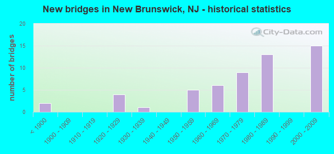
- New bridges - historical statistics
- 2Before 1900
- 41920-1929
- 11930-1939
- 51950-1959
- 61960-1969
- 91970-1979
- 131980-1989
- 152000-2009

- Reconstructed bridges - Historical Statistics
- 21960-1969
- 11970-1979
- 21980-1989
- 21990-1999
- 02000-2009
- 22010-2019


- Bridge Condition - Deck
- 3.2%Very good
- 58.1%Good
- 29.0%Satisfactory
- 6.5%Fair
- 3.2%Poor

- Bridge Condition - Superstructure
- 27.3%Very good
- 21.2%Good
- 33.3%Satisfactory
- 15.2%Fair
- 3.0%Serious

- Bridge Condition - Substructure
- 9.1%Very good
- 33.3%Good
- 39.4%Satisfactory
- 12.1%Fair
- 6.1%Poor

- Bridge Condition - Channel
- 10.5%Excellent
- 26.3%Very good
- 52.6%Good
- 10.5%Satisfactory
Find on map >> Show street view
Structure Number: 120315, Location: 0.5 MI N OF RT 18 & 1 JCT (Lat: 40.489750, Lng: -74.413350), Route carried "on" structure: US 1, Year Built: 1929, Year Reconstructed: 1975, Status: Open, Structure Length: 57.97m (190.19ft), Average Daily Traffic: 61,830 (year 2021), Truck Traffic: 4%, Average Future Daily Traffic: 74,196 (year 2041), Features Intersected: RARITAN RIVER,&LOCAL RDS
Minimum Vertical Clearance: 30+ m (98+ ft), Kilometerpoint: 44.659, Lanes on structure: 3, Lanes under structure: 3, Base Highway Network: Yes, Owner: State Highway Agency, Approaching Roadway Width: 15.2m (49.9ft), Navigation Control: Yes ( Vertical Clearance: 30.5m (100.1ft), Horizontal Clearance: 61.6m (202.1ft)), Material/Design: Concrete, Design/Construction: Arch - Deck, Number Of Spans In Main Unit: 6, Number Of Approach Spans: 9, Length of Maximum Span: 61.6m (202.1ft), Curb or Sidewalk Widths: Left: 1.9m (6.2ft), Right: 1.9m (6.2ft), Curb-To-Curb Width: 15.2m (49.9ft), Out-to-Out Width: 20.0m (65.6ft)
Condition: Deck: Satisfactory, Superstructure: Fair, Substructure: Fair, Channel: Very good, Operating Rating: 47.2 metric tons, Method Used To Determine Operating Rating: Load Factor (LF), Inventory Rating: 28.1 metric tons, Method Used To Determine Inventory Rating: Load Factor (LF), Structural Evaluation: Somewhat better than minimum adequacy, Deck Geometry: Equal to present minimum criteria, Underclear: Meets minimum limits, Waterway Adequacy: Superior to present desirable criteria, Approach Roadway Alignment: Better than present minimum criteria, Designated Inspection Frequency: Every 24 months, Underwater Inspection Frequency: Every 48 months, Inspection Date: June 2021, Underwater Inspection Date: June 2021, Deck Structure Type: Concrete Cast-file-Place, Wearing Surface/Protective System: Wearing Surface: Monolithic Concrete
Find on map >> Show street view
Structure Number: 1203156, Location: 0.7mi N of US1 & NJ18 JCT (Lat: 40.489811, Lng: -74.413739), Route carried "on" structure: US 1, Year Built: 1975, Status: Open, Structure Length: 57.55m (188.81ft), Average Daily Traffic: 56,970 (year 2021), Truck Traffic: 4%, Average Future Daily Traffic: 69,500 (year 2041), Design Load: HS 20, Features Intersected: Raritan Rivr & Local Rds
Minimum Vertical Clearance: 30+ m (98+ ft), Kilometerpoint: 44.901, Lanes on structure: 3, Lanes under structure: 1, Base Highway Network: Yes, Owner: State Highway Agency, Approaching Roadway Width: 16.2m (53.1ft), Navigation Control: Yes ( Vertical Clearance: 27.4m (89.9ft), Horizontal Clearance: 41.1m (134.8ft)), Material/Design: Steel continuous, Design/Construction: Stringer/Multi-beam, Number Of Spans In Main Unit: 8, Number Of Approach Spans: 2, Length of Maximum Span: 67.7m (222.1ft), Curb or Sidewalk Widths: Left: 0.2m (0.7ft), Right: 1.8m (5.9ft), Curb-To-Curb Width: 16.2m (53.1ft), Out-to-Out Width: 19.1m (62.7ft)
Condition: Deck: Satisfactory, Superstructure: Satisfactory, Substructure: Satisfactory, Channel: Very good, Operating Rating: 53.5 metric tons, Method Used To Determine Operating Rating: Load Factor (LF), Inventory Rating: 32.7 metric tons, Method Used To Determine Inventory Rating: Load Factor (LF), Structural Evaluation: Equal to present minimum criteria, Deck Geometry: Better than present minimum criteria, Underclear: Somewhat better than minimum adequacy, Waterway Adequacy: Superior to present desirable criteria, Approach Roadway Alignment: Equal to present desirable criteria, Designated Inspection Frequency: Every 24 months, Critical Feature Inspection Frequency: Every 24 months, Underwater Inspection Frequency: Every 48 months, Inspection Date: May 2021, Critical Feature Inspection Date: May 2021, Underwater Inspection Date: June 2019, Deck Structure Type: Concrete Cast-file-Place, Wearing Surface/Protective System: Wearing Surface: Monolithic Concrete
Find on map >> Show street view
Structure Number: 121315, Location: 0.3 MI S OF US 1 JCT (Lat: 40.482250, Lng: -74.412531), Route carried "on" structure: State highway 18, Year Built: 1931, Year Reconstructed: 1992, Status: Open, Structure Length: 6.95m (22.80ft), Average Daily Traffic: 55,189 (year 2020), Truck Traffic: 4%, Average Future Daily Traffic: 79,217 (year 2040), Design Load: HS 20, Features Intersected: WESTON'S MILL POND
Minimum Vertical Clearance: 30+ m (98+ ft), Kilometerpoint: 64.857, Lanes on structure: 4, Base Highway Network: Yes, Owner: State Highway Agency, Approaching Roadway Width: 16.8m (55.1ft), Material/Design: Concrete, Design/Construction: Arch - Deck, Number Of Spans In Main Unit: 3, Length of Maximum Span: 25.0m (82.0ft), Curb or Sidewalk Widths: Left: 0.0m, Right: 1.8m (5.9ft), Curb-To-Curb Width: 16.8m (55.1ft), Out-to-Out Width: 19.6m (64.3ft)
Condition: Deck: Satisfactory, Superstructure: Satisfactory, Substructure: Satisfactory, Channel: Good, Operating Rating: 64.4 metric tons, Method Used To Determine Operating Rating: Load Factor (LF), Inventory Rating: 38.1 metric tons, Method Used To Determine Inventory Rating: Load Factor (LF), Structural Evaluation: Equal to present minimum criteria, Deck Geometry: Somewhat better than minimum adequacy, Waterway Adequacy: Superior to present desirable criteria, Approach Roadway Alignment: Better than present minimum criteria, Designated Inspection Frequency: Every 24 months, Underwater Inspection Frequency: Every 48 months, Inspection Date: June 2020, Underwater Inspection Date: May 2020, Deck Structure Type: Concrete Cast-file-Place, Wearing Surface/Protective System: Wearing Surface: Latex Concrete, Deck Protection: Epoxy Coated Reinforcing
Find on map >> Show street view
Structure Number: 1213151, Location: 1.95 MILES NORTH OF NJ TP (Lat: 40.483000, Lng: -74.418219), Route carried "on" structure: State highway 18, Year Built: 1960, Year Reconstructed: 2015, Status: Open, Structure Length: 4.57m (14.99ft), Average Daily Traffic: 111,467 (year 2020), Truck Traffic: 4%, Average Future Daily Traffic: 133,761 (year 2040), Design Load: HL 93, Features Intersected: ROUTE US 1
Minimum Vertical Clearance: 30+ m (98+ ft), Kilometerpoint: 65.355, Lanes on structure: 8, Lanes under structure: 7, Base Highway Network: Yes, Owner: State Highway Agency, Approaching Roadway Width: 27.9m (91.5ft), Skew: 30 degrees, Material/Design: Steel, Design/Construction: Stringer/Multi-beam, Number Of Spans In Main Unit: 2, Length of Maximum Span: 25.6m (84.0ft), Curb or Sidewalk Widths: Left: 1.8m (5.9ft), Right: 0.0m, Curb-To-Curb Width: 31.2m (102.4ft), Out-to-Out Width: 35.0m (114.8ft)
Condition: Deck: Good, Superstructure: Very good, Substructure: Good, Operating Rating: 52.8 metric tons, Method Used To Determine Operating Rating: Load and Resistance Factor Rating (LRFR) rating reported by rating factor(RF) method using HL-93 loadings, Inventory Rating: 41.1 metric tons, Method Used To Determine Inventory Rating: Load and Resistance Factor Rating (LRFR) rating reported by rating factor(RF) method using HL-93 loadings, Structural Evaluation: Better than present minimum criteria, Deck Geometry: Somewhat better than minimum adequacy, Underclear: Equal to present minimum criteria, Approach Roadway Alignment: Equal to present desirable criteria, Designated Inspection Frequency: Every 24 months, Inspection Date: June 2020, Deck Structure Type: Concrete Precast Panels, Wearing Surface/Protective System: Wearing Surface: Monolithic Concrete, Deck Protection: Epoxy Coated Reinforcing
Find on map >> Show street view
Structure Number: 1213152, Location: 1.1 MILES NORTH OF NJ TPK (Lat: 40.484250, Lng: -74.419200), Route carried "on" structure: State highway 18, Year Built: 1960, Year Reconstructed: 2015, Status: Open, Structure Length: 1.89m (6.20ft), Average Daily Traffic: 56,865 (year 2020), Truck Traffic: 4%, Average Future Daily Traffic: 79,611 (year 2040), Design Load: HL 93, Features Intersected: RAMP E (US 1)
Minimum Vertical Clearance: 30+ m (98+ ft), Kilometerpoint: 65.500, Lanes on structure: 3, Lanes under structure: 1, Base Highway Network: Yes, Owner: State Highway Agency, Approaching Roadway Width: 12.6m (41.3ft), Skew: 2 degrees, Material/Design: Steel, Design/Construction: Stringer/Multi-beam, Number Of Spans In Main Unit: 1, Length of Maximum Span: 16.8m (55.1ft), Curb-To-Curb Width: 12.6m (41.3ft), Out-to-Out Width: 13.7m (44.9ft)
Condition: Deck: Good, Superstructure: Very good, Substructure: Good, Operating Rating: 85.5 metric tons, Method Used To Determine Operating Rating: Load and Resistance Factor Rating (LRFR) rating reported by rating factor(RF) method using HL-93 loadings, Inventory Rating: 69.0 metric tons, Method Used To Determine Inventory Rating: Load and Resistance Factor Rating (LRFR) rating reported by rating factor(RF) method using HL-93 loadings, Structural Evaluation: Better than present minimum criteria, Deck Geometry: Meets minimum limits, Underclear: High priority of corrective action, Approach Roadway Alignment: Equal to present minimum criteria, Length Of Structure Improvement: 1.89m (6.20ft), Designated Inspection Frequency: Every 24 months, Inspection Date: May 2020, Deck Structure Type: Concrete Cast-file-Place, Wearing Surface/Protective System: Wearing Surface: Monolithic Concrete
Find on map >> Show street view
Structure Number: 1213154, Location: 0.31 MI S OF U.S.1 (Lat: 40.482219, Lng: -74.413631), Route carried "on" structure: State highway 18, Year Built: 1988, Status: Open, Structure Length: 8.63m (28.31ft), Average Daily Traffic: 63,410 (year 2020), Truck Traffic: 4%, Average Future Daily Traffic: 77,360 (year 2040), Design Load: HS 20+Mod, Features Intersected: WESTON'S MILL POND
Minimum Vertical Clearance: 30+ m (98+ ft), Kilometerpoint: 64.857, Lanes on structure: 3, Base Highway Network: Yes, Owner: State Highway Agency, Approaching Roadway Width: 16.2m (53.1ft), Skew: 1 degrees, Material/Design: Steel, Design/Construction: Stringer/Multi-beam, Number Of Spans In Main Unit: 1, Length of Maximum Span: 83.8m (274.9ft), Curb or Sidewalk Widths: Left: 0.0m, Right: 1.8m (5.9ft), Curb-To-Curb Width: 16.1m (52.8ft), Out-to-Out Width: 18.8m (61.7ft)
Condition: Deck: Good, Superstructure: Satisfactory, Substructure: Satisfactory, Channel: Good, Inventory Rating: 83.5 metric tons, Method Used To Determine Inventory Rating: Load Factor (LF), Structural Evaluation: Equal to present minimum criteria, Deck Geometry: Better than present minimum criteria, Waterway Adequacy: Superior to present desirable criteria, Approach Roadway Alignment: Better than present minimum criteria, Designated Inspection Frequency: Every 24 months, Inspection Date: September 2020, Deck Structure Type: Concrete Cast-file-Place, Wearing Surface/Protective System: Wearing Surface: Latex Concrete, Deck Protection: Epoxy Coated Reinforcing
Find on map >> Show street view
Structure Number: 1213155, Location: NEAR RT 1&18 INTERCHANGE (Lat: 40.482500, Lng: -74.415689), Route carried "on" structure: State highway 18, Year Built: 1988, Status: Open, Structure Length: 1.65m (5.41ft), Average Daily Traffic: 56,880 (year 2020), Truck Traffic: 4%, Average Future Daily Traffic: 69,394 (year 2040), Design Load: HS 20+Mod, Features Intersected: PROPOSED RAMP "A"
Minimum Vertical Clearance: 30+ m (98+ ft), Kilometerpoint: 65.146, Lanes on structure: 4, Base Highway Network: Yes, Owner: State Highway Agency, Approaching Roadway Width: 16.5m (54.1ft), Skew: 3 degrees, Material/Design: Steel, Design/Construction: Stringer/Multi-beam, Number Of Spans In Main Unit: 1, Length of Maximum Span: 14.6m (47.9ft), Curb or Sidewalk Widths: Left: 1.8m (5.9ft), Right: 0.0m, Curb-To-Curb Width: 16.5m (54.1ft), Out-to-Out Width: 19.1m (62.7ft)
Condition: Deck: Good, Superstructure: Good, Substructure: Good, Inventory Rating: 56.2 metric tons, Method Used To Determine Inventory Rating: Load Factor (LF), Structural Evaluation: Better than present minimum criteria, Deck Geometry: Meets minimum limits, Approach Roadway Alignment: Equal to present desirable criteria, Designated Inspection Frequency: Every 24 months, Inspection Date: May 2020, Deck Structure Type: Concrete Cast-file-Place, Wearing Surface/Protective System: Wearing Surface: Latex Concrete, Deck Protection: Epoxy Coated Reinforcing
Find on map >> Show street view
Structure Number: 1214151, Location: .35 MILE SO.OF RT 27 (Lat: 40.492639, Lng: -74.438719), Route carried "on" structure: City street , Year Built: 2006, Status: Open, Structure Length: 6.49m (21.29ft), Average Daily Traffic: 15,046 (year 2020), Truck Traffic: 3%, Average Future Daily Traffic: 18,360 (year 2040), Design Load: HS 25 or greater, Features Intersected: ROUTE NJ 18, Facility Carried by Structure: NEW STREET
Minimum Vertical Clearance: 30+ m (98+ ft), Kilometerpoint: 0.982, Lanes on structure: 2, Lanes under structure: 8, Owner: State Highway Agency, Approaching Roadway Width: 13.1m (43.0ft), Skew: 10 degrees, Material/Design: Steel continuous, Design/Construction: Stringer/Multi-beam, Number Of Spans In Main Unit: 2, Length of Maximum Span: 31.7m (104.0ft), Curb or Sidewalk Widths: Left: 3.5m (11.5ft), Right: 0.0m, Curb-To-Curb Width: 13.2m (43.3ft), Out-to-Out Width: 19.4m (63.6ft)
Condition: Deck: Very good, Superstructure: Very good, Substructure: Good, Inventory Rating: 68.0 metric tons, Method Used To Determine Inventory Rating: Load Factor (LF), Structural Evaluation: Better than present minimum criteria, Deck Geometry: Somewhat better than minimum adequacy, Underclear: Better than present minimum criteria, Approach Roadway Alignment: Equal to present minimum criteria, Designated Inspection Frequency: Every 24 months, Inspection Date: November 2020, Deck Structure Type: Concrete Cast-file-Place, Wearing Surface/Protective System: Wearing Surface: Monolithic Concrete, Deck Protection: Epoxy Coated Reinforcing
Find on map >> Show street view
Structure Number: 1214153, Location: 1.1milesnorthofRt.1&Rt.18 (Lat: 40.489481, Lng: -74.437500), Route carried "on" structure: City street , Year Built: 2008, Status: Open, Structure Length: 4.54m (14.90ft), Average Daily Traffic: 2,260 (year 2020), Truck Traffic: 1%, Average Future Daily Traffic: 2,783 (year 2040), Design Load: HL 93, Features Intersected: ROUTE NJ 18, Facility Carried by Structure: COMMERCIAL AVENUE
Minimum Vertical Clearance: 30+ m (98+ ft), Kilometerpoint: 0.370, Lanes on structure: 2, Lanes under structure: 5, Owner: State Highway Agency, Approaching Roadway Width: 9.1m (29.9ft), Material/Design: Steel, Design/Construction: Stringer/Multi-beam, Number Of Spans In Main Unit: 1, Length of Maximum Span: 43.9m (144.0ft), Curb or Sidewalk Widths: Left: 3.6m (11.8ft), Right: 3.5m (11.5ft), Curb-To-Curb Width: 9.1m (29.9ft), Out-to-Out Width: 17.6m (57.7ft)
Condition: Deck: Good, Superstructure: Very good, Substructure: Good, Operating Rating: 41.8 metric tons, Method Used To Determine Operating Rating: Load and Resistance Factor Rating (LRFR) rating reported by rating factor(RF) method using HL-93 loadings, Inventory Rating: 32.4 metric tons, Method Used To Determine Inventory Rating: Load and Resistance Factor Rating (LRFR) rating reported by rating factor(RF) method using HL-93 loadings, Structural Evaluation: Better than present minimum criteria, Deck Geometry: Meets minimum limits, Underclear: High priority of corrective action, Approach Roadway Alignment: Somewhat better than minimum adequacy, Designated Inspection Frequency: Every 24 months, Inspection Date: May 2020, Deck Structure Type: Concrete Cast-file-Place, Wearing Surface/Protective System: Wearing Surface: Monolithic Concrete, Deck Protection: Epoxy Coated Reinforcing
Find on map >> Show street view
Structure Number: 122915, Location: NJ 172 & NJ 18 JCT. (Lat: 40.487011, Lng: -74.431261), Route carried "on" structure: ServiceState highway 18, Year Built: 2009, Status: Open, Structure Length: 18.29m (60.01ft), Average Daily Traffic: 19,732 (year 2021), Truck Traffic: 4%, Average Future Daily Traffic: 24,100 (year 2041), Design Load: HS 25 or greater, Features Intersected: Voorhees St
Minimum Vertical Clearance: 30+ m (98+ ft), Kilometerpoint: 66.643, Lanes on structure: 3, Lanes under structure: 1, Base Highway Network: Yes, Owner: State Highway Agency, Approaching Roadway Width: 18.5m (60.7ft), Skew: 20 degrees, Material/Design: Concrete, Design/Construction: Arch - Deck, Number Of Spans In Main Unit: 8, Number Of Approach Spans: 1, Length of Maximum Span: 182.9m (600.1ft), Curb or Sidewalk Widths: Left: 0.0m, Right: 3.6m (11.8ft), Curb-To-Curb Width: 13.2m (43.3ft), Out-to-Out Width: 18.5m (60.7ft)
Condition: Superstructure: Satisfactory, Substructure: Satisfactory, Structural Evaluation: Equal to present minimum criteria, Deck Geometry: Meets minimum limits, Approach Roadway Alignment: Equal to present desirable criteria, Designated Inspection Frequency: Every 24 months, Inspection Date: April 2021
Find on map >> Show street view
Structure Number: 1229152, Location: NJ 172 & NJ 18 JCT. (Lat: 40.486681, Lng: -74.432581), Route carried "on" structure: State highway 172, Year Built: 2009, Status: Open, Structure Length: 3.23m (10.60ft), Average Daily Traffic: 17,128 (year 2021), Truck Traffic: 4%, Average Future Daily Traffic: 20,918 (year 2041), Design Load: HL 93, Features Intersected: NJ 18
Minimum Vertical Clearance: 30+ m (98+ ft), Kilometerpoint: 1.110, Lanes on structure: 3, Lanes under structure: 5, Base Highway Network: Yes, Owner: State Highway Agency, Approaching Roadway Width: 13.2m (43.3ft), Material/Design: Steel, Design/Construction: Stringer/Multi-beam, Number Of Spans In Main Unit: 1, Length of Maximum Span: 32.3m (106.0ft), Curb or Sidewalk Widths: Left: 3.6m (11.8ft), Right: 3.6m (11.8ft), Curb-To-Curb Width: 13.2m (43.3ft), Out-to-Out Width: 21.8m (71.5ft)
Condition: Deck: Good, Superstructure: Very good, Substructure: Good, Operating Rating: 89.4 metric tons, Method Used To Determine Operating Rating: Load and Resistance Factor Rating (LRFR) rating reported by rating factor(RF) method using HL-93 loadings, Inventory Rating: 70.0 metric tons, Method Used To Determine Inventory Rating: Load and Resistance Factor Rating (LRFR) rating reported by rating factor(RF) method using HL-93 loadings, Structural Evaluation: Better than present minimum criteria, Deck Geometry: Somewhat better than minimum adequacy, Underclear: Somewhat better than minimum adequacy, Approach Roadway Alignment: Equal to present desirable criteria, Designated Inspection Frequency: Every 24 months, Inspection Date: April 2021, Deck Structure Type: Concrete Cast-file-Place, Wearing Surface/Protective System: Wearing Surface: Monolithic Concrete, Deck Protection: Epoxy Coated Reinforcing
Find on map >> Show street view
Structure Number: 123715, Location: 1.7 MI NORTH OF US 1 (Lat: 40.497150, Lng: -74.439781), Route carried "on" structure: State highway 18, Year Built: 2007, Status: Open, Structure Length: 2.90m (9.51ft), Average Daily Traffic: 101,279 (year 2020), Truck Traffic: 5%, Average Future Daily Traffic: 123,580 (year 2040), Design Load: HL 93, Features Intersected: ALBANY ST (NJ 27)
Minimum Vertical Clearance: 6.10m (20.01ft), Kilometerpoint: 68.059, Lanes on structure: 7, Lanes under structure: 4, Base Highway Network: Yes, Owner: State Highway Agency, Approaching Roadway Width: 37.2m (122.0ft), Skew: 30 degrees, Material/Design: Steel, Design/Construction: Stringer/Multi-beam, Number Of Spans In Main Unit: 1, Number Of Approach Spans: 8, Length of Maximum Span: 28.7m (94.2ft), Curb-To-Curb Width: 37.2m (122.0ft), Out-to-Out Width: 40.1m (131.6ft)
Condition: Deck: Good, Superstructure: Very good, Substructure: Very good, Operating Rating: 80.0 metric tons, Method Used To Determine Operating Rating: Load and Resistance Factor Rating (LRFR) rating reported by rating factor(RF) method using HL-93 loadings, Inventory Rating: 61.9 metric tons, Method Used To Determine Inventory Rating: Load and Resistance Factor Rating (LRFR) rating reported by rating factor(RF) method using HL-93 loadings, Structural Evaluation: Equal to present desirable criteria, Deck Geometry: Superior to present desirable criteria, Underclear: Better than present minimum criteria, Approach Roadway Alignment: Equal to present desirable criteria, Designated Inspection Frequency: Every 24 months, Inspection Date: Febuary 2020, Deck Structure Type: Concrete Cast-file-Place, Wearing Surface/Protective System: Wearing Surface: Monolithic Concrete, Deck Protection: Epoxy Coated Reinforcing
Find on map >> Show street view
Structure Number: 1237152, Location: 2.3 MILES NORTH OF US 1 (Lat: 40.503711, Lng: -74.446881), Route carried "on" structure: Ramp State highway 18, Year Built: 1982, Status: Open, Structure Length: 5.46m (17.91ft), Average Daily Traffic: 5,359 (year 2020), Truck Traffic: 5%, Average Future Daily Traffic: 6,538 (year 2040), Design Load: HS 20, Features Intersected: ROUTE NJ-18
Minimum Vertical Clearance: 30+ m (98+ ft), Kilometerpoint: 69.025, Lanes on structure: 1, Lanes under structure: 4, Owner: State Highway Agency, Approaching Roadway Width: 7.3m (24.0ft), Skew: 4 degrees, Material/Design: Steel, Design/Construction: Stringer/Multi-beam, Number Of Spans In Main Unit: 2, Length of Maximum Span: 32.0m (105.0ft), Curb or Sidewalk Widths: Left: 0.2m (0.7ft), Right: 0.2m (0.7ft), Curb-To-Curb Width: 7.5m (24.6ft), Out-to-Out Width: 8.6m (28.2ft)
Condition: Deck: Satisfactory, Superstructure: Good, Substructure: Satisfactory, Operating Rating: 57.2 metric tons, Method Used To Determine Operating Rating: Load Factor (LF), Inventory Rating: 34.5 metric tons, Method Used To Determine Inventory Rating: Load Factor (LF), Structural Evaluation: Equal to present minimum criteria, Deck Geometry: Better than present minimum criteria, Underclear: High priority of corrective action, Approach Roadway Alignment: Equal to present minimum criteria, Length Of Structure Improvement: 0.75m (2.46ft), Designated Inspection Frequency: Every 24 months, Inspection Date: May 2020, Bridge Improvement Cost: $4,000, Total Project Cost: $9,000 ( Estimate for 2020), Deck Structure Type: Concrete Cast-file-Place, Wearing Surface/Protective System: Wearing Surface: Monolithic Concrete, Deck Protection: Epoxy Coated Reinforcing
Find on map >> Show street view
Structure Number: 1237153, Location: 1 MI N OF RT 27 JCT (Lat: 40.506131, Lng: -74.451819), Route carried "on" structure: Ramp State highway 18, Year Built: 1982, Status: Open, Structure Length: 5.70m (18.70ft), Average Daily Traffic: 11,260 (year 2020), Truck Traffic: 5%, Average Future Daily Traffic: 13,739 (year 2040), Design Load: HS 20, Features Intersected: NJ RT 18 AND RAMP GS
Minimum Vertical Clearance: 30+ m (98+ ft), Kilometerpoint: 69.491, Lanes on structure: 1, Lanes under structure: 5, Owner: State Highway Agency, Approaching Roadway Width: 7.3m (24.0ft), Skew: 3 degrees, Material/Design: Steel, Design/Construction: Stringer/Multi-beam, Number Of Spans In Main Unit: 3, Length of Maximum Span: 22.3m (73.2ft), Curb or Sidewalk Widths: Left: 0.2m (0.7ft), Right: 0.2m (0.7ft), Curb-To-Curb Width: 7.5m (24.6ft), Out-to-Out Width: 8.6m (28.2ft)
Condition: Deck: Satisfactory, Superstructure: Good, Substructure: Fair, Operating Rating: 81.6 metric tons, Method Used To Determine Operating Rating: Load Factor (LF), Inventory Rating: 49.0 metric tons, Method Used To Determine Inventory Rating: Load Factor (LF), Structural Evaluation: Somewhat better than minimum adequacy, Deck Geometry: Better than present minimum criteria, Underclear: High priority of corrective action, Approach Roadway Alignment: Equal to present minimum criteria, Length Of Structure Improvement: 5.70m (18.70ft), Designated Inspection Frequency: Every 24 months, Inspection Date: August 2020, Roadway Improvement Cost: $24,000, Total Project Cost: $28,000 ( Estimate for 2020), Deck Structure Type: Concrete Cast-file-Place, Wearing Surface/Protective System: Wearing Surface: Monolithic Concrete, Deck Protection: Epoxy Coated Reinforcing
Find on map >> Show street view
Structure Number: 1237154, Location: 2.7 MILES NORTH OF US 1 (Lat: 40.506311, Lng: -74.453661), Route carried "on" structure: Ramp State highway 18, Year Built: 1982, Status: Open, Structure Length: 2.71m (8.89ft), Average Daily Traffic: 2,986 (year 2020), Truck Traffic: 5%, Average Future Daily Traffic: 3,643 (year 2040), Design Load: HS 20, Features Intersected: RAMPG(18SBTOCR672)
Minimum Vertical Clearance: 30+ m (98+ ft), Kilometerpoint: 69.524, Lanes on structure: 1, Lanes under structure: 1, Owner: State Highway Agency, Approaching Roadway Width: 7.3m (24.0ft), Skew: 6 degrees, Material/Design: Steel, Design/Construction: Stringer/Multi-beam, Number Of Spans In Main Unit: 1, Length of Maximum Span: 24.7m (81.0ft), Curb or Sidewalk Widths: Left: 0.2m (0.7ft), Right: 0.2m (0.7ft), Curb-To-Curb Width: 7.5m (24.6ft), Out-to-Out Width: 8.6m (28.2ft)
Condition: Deck: Good, Superstructure: Good, Substructure: Satisfactory, Inventory Rating: 56.2 metric tons, Method Used To Determine Inventory Rating: Load Factor (LF), Structural Evaluation: Equal to present minimum criteria, Deck Geometry: Better than present minimum criteria, Underclear: High priority of corrective action, Approach Roadway Alignment: Better than present minimum criteria, Designated Inspection Frequency: Every 24 months, Inspection Date: June 2020, Total Project Cost: $121,000 ( Estimate for 2020), Deck Structure Type: Concrete Cast-file-Place, Wearing Surface/Protective System: Wearing Surface: Latex Concrete, Deck Protection: Epoxy Coated Reinforcing
Find on map >> Show street view
Structure Number: 1237155, Location: 1.13MI W OF NJ18&27 JCT (Lat: 40.507311, Lng: -74.456961), Route carried "on" structure: State highway 18, Year Built: 1980, Status: Open, Structure Length: 31.97m (104.89ft), Average Daily Traffic: 44,520 (year 2020), Truck Traffic: 5%, Average Future Daily Traffic: 54,323 (year 2040), Design Load: HS 20, Features Intersected: RARITAN R,JOHNSON,GEORGE
Minimum Vertical Clearance: 30+ m (98+ ft), Kilometerpoint: 70.006, Lanes on structure: 5, Lanes under structure: 3, Base Highway Network: Yes, Owner: State Highway Agency, Approaching Roadway Width: 24.7m (81.0ft), Skew: 39 degrees, Navigation Control: Yes ( Vertical Clearance: 16.5m (54.1ft), Horizontal Clearance: 74.7m (245.1ft)), Material/Design: Steel continuous, Design/Construction: Girder and Floorbeam System, Number Of Spans In Main Unit: 4, Number Of Approach Spans: 1, Length of Maximum Span: 74.7m (245.1ft), Curb or Sidewalk Widths: Left: 2.0m (6.6ft), Right: 0.0m, Curb-To-Curb Width: 24.6m (80.7ft), Out-to-Out Width: 28.5m (93.5ft)
Condition: Deck: Satisfactory, Superstructure: Satisfactory, Substructure: Good, Channel: Very good, Inventory Rating: 68.0 metric tons, Method Used To Determine Inventory Rating: Load Factor (LF), Structural Evaluation: Equal to present minimum criteria, Deck Geometry: Better than present minimum criteria, Underclear: Equal to present minimum criteria, Waterway Adequacy: Superior to present desirable criteria, Approach Roadway Alignment: Equal to present desirable criteria, Designated Inspection Frequency: Every 24 months, Critical Feature Inspection Frequency: Every 24 months, Underwater Inspection Frequency: Every 48 months, Inspection Date: April 2020, Critical Feature Inspection Date: April 2020, Underwater Inspection Date: July 2018, Deck Structure Type: Concrete Cast-file-Place, Wearing Surface/Protective System: Wearing Surface: Monolithic Concrete, Deck Protection: Epoxy Coated Reinforcing
Find on map >> Show street view
Structure Number: 1237158, Location: 1.53 MI N OF NJ 27 JCT (Lat: 40.511681, Lng: -74.458861), Route carried "on" structure: State highway 18, Year Built: 2004, Status: Open, Structure Length: 31.79m (104.30ft), Average Daily Traffic: 20,515 (year 2021), Truck Traffic: 5%, Average Future Daily Traffic: 24,618 (year 2041), Features Intersected: RIVER RD, BRK&BIKE PATH
Minimum Vertical Clearance: 30+ m (98+ ft), Kilometerpoint: 70.586, Lanes on structure: 2, Lanes under structure: 4, Base Highway Network: Yes, Owner: State Highway Agency, Approaching Roadway Width: 11.7m (38.4ft), Material/Design: Steel continuous, Design/Construction: Stringer/Multi-beam, Number Of Spans In Main Unit: 9, Length of Maximum Span: 49.1m (161.1ft), Curb-To-Curb Width: 14.7m (48.2ft), Out-to-Out Width: 15.7m (51.5ft)
Condition: Deck: Good, Superstructure: Very good, Substructure: Very good, Channel: Excellent, Inventory Rating: 88.0 metric tons, Method Used To Determine Inventory Rating: Load Factor (LF), Structural Evaluation: Equal to present desirable criteria, Deck Geometry: Superior to present desirable criteria, Underclear: Superior to present desirable criteria, Waterway Adequacy: Superior to present desirable criteria, Approach Roadway Alignment: Equal to present minimum criteria, Designated Inspection Frequency: Every 24 months, Inspection Date: Febuary 2021, Deck Structure Type: Concrete Cast-file-Place, Wearing Surface/Protective System: Wearing Surface: Integral Concrete, Deck Protection: Epoxy Coated Reinforcing
Find on map >> Show street view
Structure Number: 1237159, Location: 1.5 mi from Rt NJ 27 (Lat: 40.512081, Lng: -74.458669), Route carried "on" structure: State highway 18, Year Built: 2005, Status: Open, Structure Length: 11.49m (37.70ft), Average Daily Traffic: 23,741 (year 2021), Truck Traffic: 5%, Average Future Daily Traffic: 28,488 (year 2041), Design Load: HS 20, Features Intersected: RIVER ROAD(CR.609)
Minimum Vertical Clearance: 30+ m (98+ ft), Kilometerpoint: 70.586, Lanes on structure: 2, Lanes under structure: 4, Base Highway Network: Yes, Owner: State Highway Agency, Approaching Roadway Width: 13.4m (44.0ft), Material/Design: Steel continuous, Design/Construction: Stringer/Multi-beam, Number Of Spans In Main Unit: 3, Length of Maximum Span: 44.8m (147.0ft), Curb-To-Curb Width: 13.4m (44.0ft), Out-to-Out Width: 14.4m (47.2ft)
Condition: Deck: Good, Superstructure: Very good, Substructure: Good, Operating Rating: 79.8 metric tons, Method Used To Determine Operating Rating: Load Factor (LF), Inventory Rating: 48.1 metric tons, Method Used To Determine Inventory Rating: Load Factor (LF), Structural Evaluation: Better than present minimum criteria, Deck Geometry: Superior to present desirable criteria, Underclear: Better than present minimum criteria, Approach Roadway Alignment: Equal to present desirable criteria, Designated Inspection Frequency: Every 24 months, Inspection Date: January 2021, Deck Structure Type: Concrete Cast-file-Place, Wearing Surface/Protective System: Wearing Surface: Latex Concrete, Deck Protection: Epoxy Coated Reinforcing
Find on map >> Show street view
Structure Number: 123716, Location: adjacent to river road br (Lat: 40.514661, Lng: -74.457931), Route carried "on" structure: State highway 18, Year Built: 2005, Status: Open, Structure Length: 10.24m (33.60ft), Average Daily Traffic: 36,687 (year 2021), Truck Traffic: 5%, Average Future Daily Traffic: 44,025 (year 2041), Design Load: HS 25 or greater, Features Intersected: METLARS BROOK
Minimum Vertical Clearance: 30+ m (98+ ft), Kilometerpoint: 70.731, Lanes on structure: 3, Base Highway Network: Yes, Owner: State Highway Agency, Approaching Roadway Width: 17.7m (58.1ft), Skew: 32 degrees, Material/Design: Steel continuous, Design/Construction: Stringer/Multi-beam, Number Of Spans In Main Unit: 2, Length of Maximum Span: 59.1m (193.9ft), Curb or Sidewalk Widths: Left: 0.0m, Right: 4.7m (15.4ft), Curb-To-Curb Width: 17.7m (58.1ft), Out-to-Out Width: 23.7m (77.8ft)
Condition: Deck: Good, Superstructure: Very good, Substructure: Very good, Channel: Excellent, Operating Rating: 79.8 metric tons, Method Used To Determine Operating Rating: Load Factor (LF), Inventory Rating: 47.2 metric tons, Method Used To Determine Inventory Rating: Load Factor (LF), Structural Evaluation: Equal to present desirable criteria, Deck Geometry: Better than present minimum criteria, Waterway Adequacy: Superior to present desirable criteria, Approach Roadway Alignment: Superior to present desirable criteria, Designated Inspection Frequency: Every 24 months, Inspection Date: January 2021, Deck Structure Type: Concrete Cast-file-Place, Wearing Surface/Protective System: Wearing Surface: Monolithic Concrete, Membrane: Preformed Fabric, Deck Protection: Epoxy Coated Reinforcing
Find on map >> Show street view
Structure Number: 123B14, Location: 0.49 miles south of CR606 (Lat: 40.448731, Lng: -74.446281), Route carried "on" structure: City street , Year Built: 1981, Status: Open, Structure Length: 2.01m (6.59ft), Average Daily Traffic: 4,884 (year 2021), Truck Traffic: 4%, Average Future Daily Traffic: 5,960 (year 2041), Design Load: HS 20, Features Intersected: LAWRENCE BROOK, Facility Carried by Structure: RIVA AVENUE
Minimum Vertical Clearance: 30+ m (98+ ft), Kilometerpoint: 3.911, Lanes on structure: 2, Owner: County Highway Agency, Approaching Roadway Width: 9.1m (29.9ft), Material/Design: Prestressed concrete, Design/Construction: Box Beam or Girders - Multiple, Number Of Spans In Main Unit: 1, Length of Maximum Span: 18.9m (62.0ft), Curb or Sidewalk Widths: Left: 1.5m (4.9ft), Right: 1.5m (4.9ft), Curb-To-Curb Width: 9.3m (30.5ft), Out-to-Out Width: 13.1m (43.0ft)
Condition: Deck: Good, Superstructure: Good, Substructure: Good, Channel: Good, Operating Rating: 70.8 metric tons, Method Used To Determine Operating Rating: Load Factor (LF), Inventory Rating: 41.7 metric tons, Method Used To Determine Inventory Rating: Load Factor (LF), Structural Evaluation: Better than present minimum criteria, Deck Geometry: Meets minimum limits, Waterway Adequacy: Better than present minimum criteria, Approach Roadway Alignment: Equal to present desirable criteria, Designated Inspection Frequency: Every 24 months, Inspection Date: May 2021, Deck Structure Type: Concrete Cast-file-Place, Wearing Surface/Protective System: Wearing Surface: Monolithic Concrete, Deck Protection: Epoxy Coated Reinforcing
Find on map >> Show street view
Structure Number: 123B146, Location: .5 MI EAST NJ RT 18 (Lat: 40.483231, Lng: -74.412211), Route carried "on" structure: City street , Year Built: 1965, Status: Open, Structure Length: 3.26m (10.70ft), Average Daily Traffic: 7,623 (year 2021), Truck Traffic: 3%, Average Future Daily Traffic: 9,302 (year 2041), Design Load: HS 20, Features Intersected: LAWRENCE BROOK, Facility Carried by Structure: BURNET STREET
Minimum Vertical Clearance: 30+ m (98+ ft), Kilometerpoint: 0.531, Lanes on structure: 2, Owner: County Highway Agency, Approaching Roadway Width: 9.1m (29.9ft), Skew: 1 degrees, Material/Design: Steel, Design/Construction: Stringer/Multi-beam, Number Of Spans In Main Unit: 1, Length of Maximum Span: 31.1m (102.0ft), Curb or Sidewalk Widths: Left: 0.5m (1.6ft), Right: 1.8m (5.9ft), Curb-To-Curb Width: 9.1m (29.9ft), Out-to-Out Width: 12.2m (40.0ft)
Condition: Deck: Fair, Superstructure: Satisfactory, Substructure: Good, Channel: Good, Operating Rating: 82.6 metric tons, Method Used To Determine Operating Rating: Load Factor (LF), Inventory Rating: 49.0 metric tons, Method Used To Determine Inventory Rating: Load Factor (LF), Structural Evaluation: Equal to present minimum criteria, Deck Geometry: High priority of corrective action, Waterway Adequacy: Equal to present desirable criteria, Approach Roadway Alignment: Equal to present minimum criteria, Length Of Structure Improvement: 3.26m (10.70ft), Designated Inspection Frequency: Every 24 months, Inspection Date: April 2021, Bridge Improvement Cost: $129,000, Roadway Improvement Cost: $25,000, Total Project Cost: $209,000 ( Estimate for 2021), Deck Structure Type: Concrete Cast-file-Place, Wearing Surface/Protective System: Wearing Surface: Monolithic Concrete
Find on map >> Show street view
Structure Number: 123B168, Location: 0.7 MI. S. OF N.J. 18 (Lat: 40.505531, Lng: -74.467419), Route carried "on" structure: County highway 609, Year Built: 1966, Status: Open, Structure Length: 1.04m (3.41ft), Average Daily Traffic: 28,105 (year 2021), Truck Traffic: 4%, Average Future Daily Traffic: 34,290 (year 2041), Design Load: HS 20, Features Intersected: MILE RUN BROOK, Facility Carried by Structure: LANDING LANE
Minimum Vertical Clearance: 30+ m (98+ ft), Kilometerpoint: 0.000, Lanes on structure: 2, Base Highway Network: Yes, Owner: County Highway Agency, Approaching Roadway Width: 16.8m (55.1ft), Skew: 21 degrees, Material/Design: Concrete continuous, Design/Construction: Culvert, Number Of Spans In Main Unit: 2, Length of Maximum Span: 4.9m (16.1ft), Curb or Sidewalk Widths: Left: 1.9m (6.2ft), Right: 1.8m (5.9ft), Curb-To-Curb Width: 15.0m (49.2ft), Out-to-Out Width: 20.8m (68.2ft)
Condition: Channel: Satisfactory, Culverts: Satisfactory, Operating Rating: 51.7 metric tons, Method Used To Determine Operating Rating: Field evaluation and documented engineering judgment, Inventory Rating: 30.8 metric tons, Method Used To Determine Inventory Rating: Field evaluation and documented engineering judgment, Structural Evaluation: Equal to present minimum criteria, Deck Geometry: Superior to present desirable criteria, Waterway Adequacy: Equal to present desirable criteria, Approach Roadway Alignment: Better than present minimum criteria, Designated Inspection Frequency: Every 24 months, Inspection Date: March 2021
Find on map >> Show street view
Structure Number: 123B17, Location: 0.3 MI N OF CR 527 (Lat: 40.508161, Lng: -74.464011), Route carried "on" structure: County highway 609, Year Built: 1895, Year Reconstructed: 1992, Status: Open, Structure Length: 10.94m (35.89ft), Average Daily Traffic: 30,294 (year 2021), Truck Traffic: 4%, Average Future Daily Traffic: 36,958 (year 2041), Design Load: HS 25 or greater, Features Intersected: RARITAN RIVER
Minimum Vertical Clearance: 30+ m (98+ ft), Kilometerpoint: 0.467, Lanes on structure: 2, Base Highway Network: Yes, Owner: County Highway Agency, Approaching Roadway Width: 6.7m (22.0ft), Navigation Control: Yes ( Vertical Clearance: 4.9m (16.1ft), Horizontal Clearance: 33.5m (109.9ft)), Material/Design: Steel continuous, Design/Construction: Stringer/Multi-beam, Number Of Spans In Main Unit: 3, Length of Maximum Span: 36.6m (120.1ft), Curb or Sidewalk Widths: Left: 1.6m (5.2ft), Right: 0.0m, Curb-To-Curb Width: 6.7m (22.0ft), Out-to-Out Width: 9.3m (30.5ft)
Condition: Deck: Good, Superstructure: Good, Substructure: Satisfactory, Channel: Good, Operating Rating: 89.8 metric tons, Method Used To Determine Operating Rating: Load Factor (LF), Inventory Rating: 61.7 metric tons, Method Used To Determine Inventory Rating: Load Factor (LF), Structural Evaluation: Equal to present minimum criteria, Deck Geometry: High priority of replacement, Waterway Adequacy: Equal to present desirable criteria, Approach Roadway Alignment: High priority of corrective action, Length Of Structure Improvement: 10.94m (35.89ft), Designated Inspection Frequency: Every 24 months, Underwater Inspection Frequency: Every 48 months, Inspection Date: June 2021, Underwater Inspection Date: August 2019, Bridge Improvement Cost: $1,120,000, Roadway Improvement Cost: $112,000, Total Project Cost: $1,829,000 ( Estimate for 2021), Deck Structure Type: Concrete Cast-file-Place, Wearing Surface/Protective System: Wearing Surface: Monolithic Concrete, Deck Protection: Epoxy Coated Reinforcing
Find on map >> Show street view
Structure Number: 123B171, Location: 1.15 MI N.HAMILTON CR 514 (Lat: 40.505031, Lng: -74.467111), Route carried "on" structure: County highway 527, Year Built: 1878, Year Reconstructed: 2003, Status: Open, Structure Length: 0.67m (2.20ft), Average Daily Traffic: 20,300 (year 2021), Truck Traffic: 4%, Average Future Daily Traffic: 24,770 (year 2041), Design Load: H 20, Features Intersected: MILE RUN BROOK, Facility Carried by Structure: EASTON AVENUE
Minimum Vertical Clearance: 30+ m (98+ ft), Kilometerpoint: 77.409, Lanes on structure: 2, Base Highway Network: Yes, Owner: County Highway Agency, Approaching Roadway Width: 12.5m (41.0ft), Skew: 1 degrees, Material/Design: Masonry, Design/Construction: Arch - Deck, Number Of Spans In Main Unit: 1, Length of Maximum Span: 6.7m (22.0ft), Curb or Sidewalk Widths: Left: 3.7m (12.1ft), Right: 3.6m (11.8ft), Curb-To-Curb Width: 9.5m (31.2ft), Out-to-Out Width: 18.5m (60.7ft)
Condition: Superstructure: Satisfactory, Substructure: Satisfactory, Channel: Satisfactory, Operating Rating: 29.9 metric tons, Method Used To Determine Operating Rating: Field evaluation and documented engineering judgment, Inventory Rating: 18.1 metric tons, Method Used To Determine Inventory Rating: Field evaluation and documented engineering judgment, Structural Evaluation: Meets minimum limits, Deck Geometry: High priority of corrective action, Waterway Adequacy: Better than present minimum criteria, Approach Roadway Alignment: Equal to present desirable criteria, Length Of Structure Improvement: 0.67m (2.20ft), Designated Inspection Frequency: Every 24 months, Inspection Date: March 2021, Bridge Improvement Cost: $8,000, Roadway Improvement Cost: $9,000, Total Project Cost: $40,000 ( Estimate for 2021)
Find on map >> Show street view
Structure Number: 1249166, Location: 0.18 MILES WEST OF NJ 26 (Lat: 40.467181, Lng: -74.477111), Route carried "on" structure: County highway 680, Year Built: 1950, Status: Open, Structure Length: 4.21m (13.81ft), Average Daily Traffic: 21,010 (year 2020), Truck Traffic: 3%, Average Future Daily Traffic: 28,300 (year 2040), Design Load: H 20, Features Intersected: AMTRAK NE CORRIDOR
Minimum Vertical Clearance: 30+ m (98+ ft), Kilometerpoint: 1.304, Lanes on structure: 2, Maintenance Responsibility: State Highway Agency, Approaching Roadway Width: 9.1m (29.9ft), Material/Design: Steel continuous, Design/Construction: Stringer/Multi-beam, Number Of Spans In Main Unit: 3, Length of Maximum Span: 20.1m (65.9ft), Curb or Sidewalk Widths: Left: 0.0m, Right: 1.8m (5.9ft), Curb-To-Curb Width: 9.2m (30.2ft), Out-to-Out Width: 11.9m (39.0ft)
Condition: Deck: Fair, Superstructure: Fair, Substructure: Fair, Operating Rating: 59.0 metric tons, Method Used To Determine Operating Rating: Load Factor (LF), Inventory Rating: 35.4 metric tons, Method Used To Determine Inventory Rating: Load Factor (LF), Structural Evaluation: Somewhat better than minimum adequacy, Deck Geometry: High priority of corrective action, Underclear: Meets minimum limits, Approach Roadway Alignment: Equal to present minimum criteria, Length Of Structure Improvement: 4.21m (13.81ft), Designated Inspection Frequency: Every 24 months, Inspection Date: November 2020, Bridge Improvement Cost: $79,000, Roadway Improvement Cost: $24,000, Total Project Cost: $170,000 ( Estimate for 2020), Deck Structure Type: Concrete Cast-file-Place, Wearing Surface/Protective System: Wearing Surface: Bituminous
Find on map >> Show street view
Structure Number: 3000163, Location: 0.23 MI E OF CR 533 JCT (Lat: 40.438131, Lng: -74.614011), Route carried "on" structure: County highway 632, Year Built: 1950, Year Reconstructed: 1990, Status: Open, Structure Length: 1.43m (4.69ft), Average Daily Traffic: 6,022 (year 2020), Truck Traffic: 3%, Average Future Daily Traffic: 7,227 (year 2040), Design Load: HS 20, Features Intersected: D&R CANAL, Facility Carried by Structure: GRIGGSTOWN CAUSEWA
Minimum Vertical Clearance: 30+ m (98+ ft), Kilometerpoint: 4.908, Lanes on structure: 2, Owner: State Agenciy, Maintenance Responsibility: State Highway Agency, Approaching Roadway Width: 6.7m (22.0ft), Material/Design: Wood or Timber, Design/Construction: Stringer/Multi-beam, Number Of Spans In Main Unit: 3, Length of Maximum Span: 4.6m (15.1ft), Curb or Sidewalk Widths: Left: 1.8m (5.9ft), Right: 1.8m (5.9ft), Curb-To-Curb Width: 9.1m (29.9ft), Out-to-Out Width: 12.8m (42.0ft)
Condition: Deck: Good, Superstructure: Satisfactory, Substructure: Poor, Channel: Good, Operating Rating: 26.4 metric tons, Method Used To Determine Operating Rating: Allowable Stress (AS), Inventory Rating: 18.5 metric tons, Method Used To Determine Inventory Rating: Allowable Stress (AS), Structural Evaluation: Meets minimum limits, Deck Geometry: High priority of corrective action, Waterway Adequacy: Equal to present minimum criteria, Approach Roadway Alignment: Equal to present minimum criteria, Length Of Structure Improvement: 1.43m (4.69ft), Designated Inspection Frequency: Every 24 months, Underwater Inspection Frequency: Every 24 months, Inspection Date: April 2020, Underwater Inspection Date: April 2020, Bridge Improvement Cost: $1,000, Total Project Cost: $1,000 ( Estimate for 2020), Deck Structure Type: Wood or Timber, Wearing Surface/Protective System: Wearing Surface: Wood or Timber
Find on map >> Show street view
Structure Number: 3000169, Location: 0.29 MI N OF CO RT527 JCT (Lat: 40.507831, Lng: -74.463981), Route carried "on" structure: County highway 609, Year Built: 1920, Status: Open, Structure Length: 2.26m (7.41ft), Average Daily Traffic: 21,822 (year 2020), Truck Traffic: 4%, Average Future Daily Traffic: 26,627 (year 2040), Features Intersected: DELAWARE & RARITAN CANAL
Minimum Vertical Clearance: 30+ m (98+ ft), Kilometerpoint: 0.386, Lanes on structure: 2, Base Highway Network: Yes, Owner: State Agenciy, Maintenance Responsibility: State Highway Agency, Approaching Roadway Width: 6.3m (20.7ft), Material/Design: Steel continuous, Design/Construction: Girder and Floorbeam System, Number Of Spans In Main Unit: 2, Length of Maximum Span: 13.4m (44.0ft), Curb or Sidewalk Widths: Left: 1.5m (4.9ft), Right: 0.2m (0.7ft), Curb-To-Curb Width: 6.3m (20.7ft), Out-to-Out Width: 6.5m (21.3ft)
Condition: Deck: Poor, Superstructure: Serious, Substructure: Poor, Channel: Good, Operating Rating: 35.4 metric tons, Method Used To Determine Operating Rating: Load Factor (LF), Inventory Rating: 20.9 metric tons, Method Used To Determine Inventory Rating: Load Factor (LF), Structural Evaluation: High priority of corrective action, Deck Geometry: High priority of replacement, Waterway Adequacy: Equal to present minimum criteria, Approach Roadway Alignment: Equal to present minimum criteria, Length Of Structure Improvement: 3.05m (10.01ft), Designated Inspection Frequency: Every 24 months, Critical Feature Inspection Frequency: Every 24 months, Underwater Inspection Frequency: Every 24 months, Other Special Inspection Frequency: Every 12 months, Inspection Date: October 2020, Critical Feature Inspection Date: October 2020, Underwater Inspection Date: May 2020, Other Special Inspection Date: December 2021, Bridge Improvement Cost: $1,817,000, Roadway Improvement Cost: $200,000, Total Project Cost: $3,026,000 ( Estimate for 2020), Deck Structure Type: Corrugated Steel, Wearing Surface/Protective System: Wearing Surface: Bituminous
Find on map >> Show street view
Structure Number: M08353, Location: .1 MI N INTERCHANGE 9 (Lat: 40.480136, Lng: -74.404822), Route carried "on" structure: Ramp Interstate 95, Year Built: 1951, Year Reconstructed: 1972, Status: Open, Structure Length: 7.68m (25.20ft), Average Daily Traffic: 32,147 (year 2021), Truck Traffic: 9%, Average Future Daily Traffic: 39,226 (year 2041), Design Load: HS 20, Features Intersected: LAWRENCE BROOK, Facility Carried by Structure: NJTPK INT 9 RP NT
Minimum Vertical Clearance: 30+ m (98+ ft), Kilometerpoint: 61.477, Lanes on structure: 2, Toll: On toll road, Owner: State Toll Authority, Approaching Roadway Width: 13.4m (44.0ft), Material/Design: Steel, Design/Construction: Stringer/Multi-beam, Number Of Spans In Main Unit: 3, Length of Maximum Span: 30.2m (99.1ft), Curb or Sidewalk Widths: Left: 0.0m, Right: 0.6m (2.0ft), Curb-To-Curb Width: 12.5m (41.0ft), Out-to-Out Width: 23.2m (76.1ft)
Condition: Deck: Satisfactory, Superstructure: Satisfactory, Substructure: Satisfactory, Channel: Very good, Operating Rating: 57.0 metric tons, Method Used To Determine Operating Rating: Load and Resistance Factor Rating (LRFR) rating reported by rating factor(RF) method using HL-93 loadings, Inventory Rating: 44.1 metric tons, Method Used To Determine Inventory Rating: Load and Resistance Factor Rating (LRFR) rating reported by rating factor(RF) method using HL-93 loadings, Structural Evaluation: Equal to present minimum criteria, Deck Geometry: Superior to present desirable criteria, Waterway Adequacy: Equal to present desirable criteria, Approach Roadway Alignment: Equal to present desirable criteria, Designated Inspection Frequency: Every 24 months, Inspection Date: June 2021, Deck Structure Type: Concrete Cast-file-Place, Wearing Surface/Protective System: Wearing Surface: Bituminous, Membrane: Other
Find on map >> Show street view
Structure Number: M08355, Location: .1 MI N INTERCHANGE 9 (Lat: 40.479797, Lng: -74.403514), Route carried "on" structure: Interstate 95, Year Built: 1973, Status: Open, Structure Length: 6.00m (19.69ft), Average Daily Traffic: 115,620 (year 2021), Truck Traffic: 28%, Average Future Daily Traffic: 141,079 (year 2041), Design Load: HS 20, Features Intersected: LAWRENCE BROOK
Minimum Vertical Clearance: 30+ m (98+ ft), Kilometerpoint: 61.477, Lanes on structure: 7, Base Highway Network: Yes, Toll: On toll road, Owner: State Toll Authority, Approaching Roadway Width: 43.3m (142.1ft), Skew: 30 degrees, Material/Design: Steel, Design/Construction: Stringer/Multi-beam, Number Of Spans In Main Unit: 3, Length of Maximum Span: 30.2m (99.1ft), Curb-To-Curb Width: 42.1m (138.1ft), Out-to-Out Width: 44.2m (145.0ft)
Condition: Deck: Good, Superstructure: Satisfactory, Substructure: Satisfactory, Channel: Good, Operating Rating: 42.8 metric tons, Method Used To Determine Operating Rating: Load and Resistance Factor Rating (LRFR) rating reported by rating factor(RF) method using HL-93 loadings, Inventory Rating: 31.4 metric tons, Method Used To Determine Inventory Rating: Load and Resistance Factor Rating (LRFR) rating reported by rating factor(RF) method using HL-93 loadings, Structural Evaluation: Equal to present minimum criteria, Deck Geometry: Superior to present desirable criteria, Waterway Adequacy: Equal to present desirable criteria, Approach Roadway Alignment: Equal to present desirable criteria, Designated Inspection Frequency: Every 24 months, Inspection Date: June 2021, Deck Structure Type: Concrete Cast-file-Place, Wearing Surface/Protective System: Wearing Surface: Bituminous, Membrane: Other
Find on map >> Show street view
Structure Number: M08355N, Location: .1 MI N INTERCHANGE 9 (Lat: 40.479950, Lng: -74.403139), Route carried "on" structure: Interstate 95, Year Built: 1973, Status: Open, Structure Length: 6.00m (19.69ft), Average Daily Traffic: 55,580 (year 2021), Truck Traffic: 28%, Average Future Daily Traffic: 67,818 (year 2041), Design Load: HS 20, Features Intersected: LAWRENCE BROOK
Minimum Vertical Clearance: 30+ m (98+ ft), Kilometerpoint: 61.477, Lanes on structure: 3, Base Highway Network: Yes, Toll: On toll road, Owner: State Toll Authority, Approaching Roadway Width: 21.3m (69.9ft), Material/Design: Steel, Design/Construction: Stringer/Multi-beam, Number Of Spans In Main Unit: 3, Length of Maximum Span: 24.7m (81.0ft), Curb-To-Curb Width: 20.7m (67.9ft), Out-to-Out Width: 21.8m (71.5ft)
Condition: Deck: Good, Superstructure: Satisfactory, Substructure: Fair, Channel: Very good, Operating Rating: 46.7 metric tons, Method Used To Determine Operating Rating: Load and Resistance Factor Rating (LRFR) rating reported by rating factor(RF) method using HL-93 loadings, Inventory Rating: 34.3 metric tons, Method Used To Determine Inventory Rating: Load and Resistance Factor Rating (LRFR) rating reported by rating factor(RF) method using HL-93 loadings, Structural Evaluation: Somewhat better than minimum adequacy, Deck Geometry: Superior to present desirable criteria, Waterway Adequacy: Equal to present desirable criteria, Approach Roadway Alignment: Equal to present desirable criteria, Designated Inspection Frequency: Every 24 months, Inspection Date: June 2021, Deck Structure Type: Concrete Cast-file-Place, Wearing Surface/Protective System: Wearing Surface: Bituminous, Membrane: Other
Find on map >> Show street view
Structure Number: M08355S, Location: .1 MI N INTERCHANGE 9 (Lat: 40.480017, Lng: -74.404247), Route carried "on" structure: Interstate 95, Year Built: 1973, Status: Open, Structure Length: 6.00m (19.69ft), Average Daily Traffic: 55,580 (year 2019), Truck Traffic: 19%, Average Future Daily Traffic: 67,818 (year 2039), Design Load: HS 20, Features Intersected: LAWRENCE BROOK
Minimum Vertical Clearance: 30+ m (98+ ft), Kilometerpoint: 61.477, Lanes on structure: 3, Base Highway Network: Yes, Toll: On toll road, Owner: State Toll Authority, Approaching Roadway Width: 18.0m (59.1ft), Material/Design: Steel, Design/Construction: Stringer/Multi-beam, Number Of Spans In Main Unit: 3, Length of Maximum Span: 30.2m (99.1ft), Curb-To-Curb Width: 16.8m (55.1ft), Out-to-Out Width: 18.0m (59.1ft)
Condition: Deck: Good, Superstructure: Good, Substructure: Good, Operating Rating: 43.1 metric tons, Method Used To Determine Operating Rating: Load and Resistance Factor Rating (LRFR) rating reported by rating factor(RF) method using HL-93 loadings, Inventory Rating: 33.0 metric tons, Method Used To Determine Inventory Rating: Load and Resistance Factor Rating (LRFR) rating reported by rating factor(RF) method using HL-93 loadings, Structural Evaluation: Better than present minimum criteria, Deck Geometry: Equal to present minimum criteria, Waterway Adequacy: Equal to present desirable criteria, Approach Roadway Alignment: Equal to present desirable criteria, Designated Inspection Frequency: Every 24 months, Inspection Date: June 2021, Deck Structure Type: Concrete Cast-file-Place, Wearing Surface/Protective System: Wearing Surface: Bituminous, Membrane: Other
Find on map >> Show street view
Structure Number: M08372, Location: .1 MI N INTERCHANGE 9 (Lat: 40.482083, Lng: -74.403097), Route carried "on" structure: Ramp Interstate 95, Year Built: 1973, Status: Open, Structure Length: 10.36m (33.99ft), Average Daily Traffic: 17,756 (year 2021), Truck Traffic: 1%, Average Future Daily Traffic: 21,666 (year 2041), Design Load: HS 20, Features Intersected: NJTPK(I-95) NSO ROADWAY, Facility Carried by Structure: NJTPK INT9 RAMPNIT
Minimum Vertical Clearance: 30+ m (98+ ft), Kilometerpoint: 61.799, Lanes on structure: 1, Lanes under structure: 3, Toll: On toll road, Owner: State Toll Authority, Approaching Roadway Width: 7.3m (24.0ft), Skew: 6 degrees, Material/Design: Steel, Design/Construction: Stringer/Multi-beam, Number Of Spans In Main Unit: 4, Length of Maximum Span: 32.9m (107.9ft), Curb-To-Curb Width: 7.3m (24.0ft), Out-to-Out Width: 9.1m (29.9ft)
Condition: Deck: Good, Superstructure: Fair, Substructure: Satisfactory, Operating Rating: 32.7 metric tons, Method Used To Determine Operating Rating: Load and Resistance Factor Rating (LRFR) rating reported by rating factor(RF) method using HL-93 loadings, Inventory Rating: 25.3 metric tons, Method Used To Determine Inventory Rating: Load and Resistance Factor Rating (LRFR) rating reported by rating factor(RF) method using HL-93 loadings, Structural Evaluation: Somewhat better than minimum adequacy, Deck Geometry: Better than present minimum criteria, Underclear: High priority of corrective action, Approach Roadway Alignment: Equal to present desirable criteria, Designated Inspection Frequency: Every 24 months, Critical Feature Inspection Frequency: Every 24 months, Inspection Date: April 2021, Critical Feature Inspection Date: April 2021, Deck Structure Type: Concrete Cast-file-Place, Wearing Surface/Protective System: Wearing Surface: Bituminous
Find on map >> Show street view
Structure Number: M08424N, Location: .7 MI N OF INT 9 (Lat: 40.488333, Lng: -74.396667), Route carried "on" structure: Interstate 95, Year Built: 1973, Status: Open, Structure Length: 24.54m (80.51ft), Average Daily Traffic: 97,307 (year 2020), Truck Traffic: 12%, Average Future Daily Traffic: 123,554 (year 2040), Design Load: HS 20, Features Intersected: RARITAN RIVER&NJTPK UTRN, Facility Carried by Structure: NJTPK SNO-SNI RWYS
Minimum Vertical Clearance: 30+ m (98+ ft), Kilometerpoint: 62.587, Lanes on structure: 6, Lanes under structure: 2, Base Highway Network: Yes, Toll: On toll road, Owner: State Toll Authority, Approaching Roadway Width: 18.6m (61.0ft), Skew: 31 degrees, Navigation Control: Yes ( Vertical Clearance: 13.7m (44.9ft), Horizontal Clearance: 45.7m (149.9ft)), Material/Design: Steel continuous, Design/Construction: Girder and Floorbeam System, Number Of Spans In Main Unit: 3, Number Of Approach Spans: 1, Length of Maximum Span: 64.9m (212.9ft), Curb-To-Curb Width: 37.4m (122.7ft), Out-to-Out Width: 38.9m (127.6ft)
Condition: Deck: Satisfactory, Superstructure: Fair, Substructure: Satisfactory, Channel: Good, Operating Rating: 51.4 metric tons, Method Used To Determine Operating Rating: Load Factor (LF), Inventory Rating: 30.8 metric tons, Method Used To Determine Inventory Rating: Load Factor (LF), Structural Evaluation: Somewhat better than minimum adequacy, Deck Geometry: Superior to present desirable criteria, Underclear: Meets minimum limits, Waterway Adequacy: Equal to present desirable criteria, Approach Roadway Alignment: Equal to present desirable criteria, Designated Inspection Frequency: Every 24 months, Critical Feature Inspection Frequency: Every 24 months, Underwater Inspection Frequency: Every 60 months, Inspection Date: April 2020, Critical Feature Inspection Date: April 2020, Underwater Inspection Date: July 2020, Deck Structure Type: Concrete Cast-file-Place, Wearing Surface/Protective System: Wearing Surface: Bituminous
Find on map >> Show street view
Structure Number: M08424S, Location: .7 MI N INT 9 (Lat: 40.488333, Lng: -74.396667), Route carried "on" structure: Interstate 95, Year Built: 1952, Year Reconstructed: 1973, Status: Open, Structure Length: 24.54m (80.51ft), Average Daily Traffic: 97,367 (year 2020), Truck Traffic: 13%, Average Future Daily Traffic: 123,630 (year 2040), Design Load: HS 20, Features Intersected: RARITAN RIVER & NJTP, Facility Carried by Structure: NJ TP NSO-NSI RWYS
Minimum Vertical Clearance: 30+ m (98+ ft), Kilometerpoint: 62.587, Lanes on structure: 6, Lanes under structure: 2, Base Highway Network: Yes, Toll: On toll road, Owner: State Toll Authority, Approaching Roadway Width: 18.3m (60.0ft), Skew: 30 degrees, Navigation Control: Yes ( Vertical Clearance: 13.7m (44.9ft), Horizontal Clearance: 45.7m (149.9ft)), Material/Design: Steel continuous, Design/Construction: Girder and Floorbeam System, Number Of Spans In Main Unit: 3, Length of Maximum Span: 64.9m (212.9ft), Curb-To-Curb Width: 36.8m (120.7ft), Out-to-Out Width: 38.3m (125.7ft)
Condition: Deck: Satisfactory, Superstructure: Fair, Substructure: Satisfactory, Channel: Good, Operating Rating: 46.9 metric tons, Method Used To Determine Operating Rating: Load Factor (LF), Inventory Rating: 28.1 metric tons, Method Used To Determine Inventory Rating: Load Factor (LF), Structural Evaluation: Somewhat better than minimum adequacy, Deck Geometry: Superior to present desirable criteria, Underclear: Meets minimum limits, Waterway Adequacy: Equal to present desirable criteria, Approach Roadway Alignment: Better than present minimum criteria, Designated Inspection Frequency: Every 24 months, Critical Feature Inspection Frequency: Every 24 months, Underwater Inspection Frequency: Every 60 months, Inspection Date: April 2020, Critical Feature Inspection Date: April 2020, Underwater Inspection Date: July 2020, Deck Structure Type: Concrete Cast-file-Place, Wearing Surface/Protective System: Wearing Surface: Bituminous
Find on map >> Show street view
Structure Number: 120315, Location: 0.5 MI N OF RT 18 & 1 JCT (Lat: 40.489750, Lng: -74.413350), Route carried "under" structure: Ramp US 1, Year Built: 1929, Structure Length: 0. m, Average Daily Traffic: 1,305 (year 2021), Truck Traffic: 4%, Features Intersected: RARITAN RIVER,&LOCAL RDS
Minimum Vertical Clearance: 4.94m (16.21ft), Kilometerpoint: 44.659, Lanes on structure: 3, Lanes under structure: 1, Material/Design: Concrete, Design/Construction: Arch - Deck, Length of Maximum Span: 61.6m (202.1ft)
Find on map >> Show street view
Structure Number: 120315, Location: 0.5 MI N OF RT 18 & 1 JCT (Lat: 40.489750, Lng: -74.413350), Route carried "under" structure: City street , Year Built: 1929, Structure Length: 0. m, Features Intersected: RARITAN RIVER,&LOCAL RDS, Facility Carried by Structure: US 1 NB
Minimum Vertical Clearance: 6.86m (22.51ft), Kilometerpoint: 0.000, Lanes on structure: 3, Lanes under structure: 2, Material/Design: Concrete, Design/Construction: Arch - Deck, Length of Maximum Span: 61.6m (202.1ft)
Find on map >> Show street view
Structure Number: 1203156, Location: 0.7mi N of US1 & NJ18 JCT (Lat: 40.489811, Lng: -74.413739), Route carried "under" structure: Ramp US 1, Year Built: 1975, Structure Length: 0. m, Average Daily Traffic: 2,695 (year 2021), Truck Traffic: 4%, Features Intersected: Raritan Rivr & Local Rds
Minimum Vertical Clearance: 4.80m (15.75ft), Kilometerpoint: 45.142, Lanes on structure: 3, Lanes under structure: 1, Material/Design: Steel continuous, Design/Construction: Stringer/Multi-beam, Length of Maximum Span: 67.7m (222.1ft)
Find on map >> Show street view
Structure Number: 1213151, Location: 1.95 MILES NORTH OF NJ TP (Lat: 40.483000, Lng: -74.418219), Route carried "under" structure: US 1, Year Built: 1960, Structure Length: 0. m, Average Daily Traffic: 118,842 (year 2020), Truck Traffic: 4%, Features Intersected: ROUTE US 1
Minimum Vertical Clearance: 5.61m (18.41ft), Kilometerpoint: 43.758, Lanes on structure: 8, Lanes under structure: 7, Material/Design: Steel, Design/Construction: Stringer/Multi-beam, Length of Maximum Span: 25.6m (84.0ft)
Find on map >> Show street view
Structure Number: 1213152, Location: 1.1 MILES NORTH OF NJ TPK (Lat: 40.484250, Lng: -74.419200), Route carried "under" structure: Ramp US 1, Year Built: 1960, Structure Length: 0. m, Average Daily Traffic: 11,200 (year 2020), Truck Traffic: 4%, Features Intersected: RAMP E (US 1)
Minimum Vertical Clearance: 4.65m (15.26ft), Kilometerpoint: 43.726, Lanes on structure: 3, Lanes under structure: 1, Material/Design: Steel, Design/Construction: Stringer/Multi-beam, Length of Maximum Span: 16.8m (55.1ft)
Find on map >> Show street view
Structure Number: 1214151, Location: .35 MILE SO.OF RT 27 (Lat: 40.492639, Lng: -74.438719), Route carried "under" structure: State highway 18, Year Built: 2006, Structure Length: 0. m, Average Daily Traffic: 96,981 (year 2020), Truck Traffic: 4%, Features Intersected: ROUTE NJ 18, Facility Carried by Structure: NEW STREET
Minimum Vertical Clearance: 6.35m (20.83ft), Kilometerpoint: 67.528, Lanes on structure: 2, Lanes under structure: 8, Material/Design: Steel continuous, Design/Construction: Stringer/Multi-beam, Length of Maximum Span: 31.7m (104.0ft)
Find on map >> Show street view
Structure Number: 1214153, Location: 1.1milesnorthofRt.1&Rt.18 (Lat: 40.489481, Lng: -74.437500), Route carried "under" structure: State highway 18, Year Built: 2008, Structure Length: 0. m, Average Daily Traffic: 70,286 (year 2020), Truck Traffic: 5%, Features Intersected: ROUTE NJ 18, Facility Carried by Structure: COMMERCIAL AVENUE
Minimum Vertical Clearance: 5.51m (18.08ft), Kilometerpoint: 67.190, Lanes on structure: 2, Lanes under structure: 5, Material/Design: Steel, Design/Construction: Stringer/Multi-beam, Length of Maximum Span: 43.9m (144.0ft)
Find on map >> Show street view
Structure Number: 122915, Location: NJ 172 & NJ 18 JCT. (Lat: 40.487011, Lng: -74.431261), Route carried "under" structure: ServiceCity street , Year Built: 2009, Structure Length: 0. m, Average Daily Traffic: 125 (year 2021), Truck Traffic: 1%, Features Intersected: Voorhees St, Facility Carried by Structure: NJ 18 SERVICE
Minimum Vertical Clearance: 4.47m (14.67ft), Kilometerpoint: 66.643, Lanes on structure: 3, Lanes under structure: 1, Material/Design: Concrete, Design/Construction: Arch - Deck, Length of Maximum Span: 182.9m (600.1ft)