Bridge Statistics for Morristown, New Jersey (NJ)
Condition, Traffic, Stress, Structural Evaluation, Project Costs
- National Bridge Inventory (NBI) Statistics
- 49Number of bridges
- 407ft / 124mTotal length
- $52,603,000Total costs
- 2,079,191Total average daily traffic
- 167,206Total average daily truck traffic
- National Bridge Inventory (NBI) Registered Bridges for Morristown
- No street view available for this location
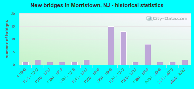
- New bridges - historical statistics
- 1Before 1900
- 21900-1909
- 11910-1919
- 11920-1929
- 11930-1939
- 21940-1949
- 151960-1969
- 131970-1979
- 11980-1989
- 81990-1999
- 12000-2009
- 12010-2019
- 22020-2022

- Reconstructed bridges - Historical Statistics
- 11910-1919
- 11920-1929
- 01930-1939
- 01940-1949
- 01950-1959
- 01960-1969
- 01970-1979
- 11980-1989
- 41990-1999
- 22000-2009
- 12010-2019


- Bridge Condition - Deck
- 3.4%Excellent
- 10.3%Very good
- 31.0%Good
- 24.1%Satisfactory
- 27.6%Fair
- 3.4%Poor

- Bridge Condition - Superstructure
- 6.3%Excellent
- 9.4%Very good
- 43.8%Good
- 28.1%Satisfactory
- 9.4%Fair
- 3.1%Poor

- Bridge Condition - Substructure
- 6.3%Excellent
- 6.3%Very good
- 28.1%Good
- 43.8%Satisfactory
- 15.6%Fair

- Bridge Condition - Channel
- 4.5%Good
- 72.7%Satisfactory
- 18.2%Fair
- 4.5%Poor

- Bridge Condition - Culverts
- 66.7%Satisfactory
- 33.3%Fair
Find on map >> Show street view
Structure Number: 1400118, Location: 1MI NW OF NJ124&I287 JCT (Lat: 40.801119, Lng: -74.477881), Route carried "on" structure: City street , Year Built: 1900, Year Reconstructed: 1928, Status: Open, Structure Length: 2.01m (6.59ft), Average Daily Traffic: 12,909 (year 2021), Truck Traffic: 4%, Average Future Daily Traffic: 15,752 (year 2041), Features Intersected: WHIPPANY RIVER, Facility Carried by Structure: MARTIN L KING AVE
Minimum Vertical Clearance: 30+ m (98+ ft), Kilometerpoint: 0.209, Lanes on structure: 2, Owner: County Highway Agency, Approaching Roadway Width: 9.4m (30.8ft), Skew: 3 degrees, Material/Design: Masonry, Design/Construction: Arch - Deck, Number Of Spans In Main Unit: 3, Length of Maximum Span: 5.5m (18.0ft), Curb or Sidewalk Widths: Left: 1.7m (5.6ft), Right: 2.4m (7.9ft), Curb-To-Curb Width: 9.3m (30.5ft), Out-to-Out Width: 14.0m (45.9ft)
Condition: Superstructure: Poor, Substructure: Fair, Channel: Satisfactory, Operating Rating: 47.2 metric tons, Method Used To Determine Operating Rating: Field evaluation and documented engineering judgment, Inventory Rating: 28.1 metric tons, Method Used To Determine Inventory Rating: Field evaluation and documented engineering judgment, Structural Evaluation: Meets minimum limits, Deck Geometry: High priority of corrective action, Waterway Adequacy: Better than present minimum criteria, Approach Roadway Alignment: Equal to present minimum criteria, Length Of Structure Improvement: 2.01m (6.59ft), Designated Inspection Frequency: Every 24 months, Inspection Date: June 2021, Bridge Improvement Cost: $1,229,000, Roadway Improvement Cost: $60,000, Total Project Cost: $1,763,000 ( Estimate for 2021)
Find on map >> Show street view
Structure Number: 1400119, Location: 0.9MI NW NJ124&I287 JCT (Lat: 40.799400, Lng: -74.478569), Route carried "on" structure: City street , Year Built: 1930, Year Reconstructed: 1993, Status: Open, Structure Length: 1.52m (4.99ft), Average Daily Traffic: 7,167 (year 2021), Truck Traffic: 1%, Average Future Daily Traffic: 8,745 (year 2041), Design Load: HS 20+Mod, Features Intersected: WHIPPANY RIVER, Facility Carried by Structure: BISHOP NAZERY WAY
Minimum Vertical Clearance: 30+ m (98+ ft), Kilometerpoint: 0.000, Lanes on structure: 2, Owner: County Highway Agency, Approaching Roadway Width: 11.6m (38.1ft), Material/Design: Prestressed concrete, Design/Construction: Box Beam or Girders - Multiple, Number Of Spans In Main Unit: 1, Length of Maximum Span: 14.0m (45.9ft), Curb or Sidewalk Widths: Left: 1.9m (6.2ft), Right: 1.9m (6.2ft), Curb-To-Curb Width: 9.3m (30.5ft), Out-to-Out Width: 13.9m (45.6ft)
Condition: Deck: Satisfactory, Superstructure: Satisfactory, Substructure: Good, Channel: Satisfactory, Inventory Rating: 60.8 metric tons, Method Used To Determine Inventory Rating: Load Factor (LF), Structural Evaluation: Equal to present minimum criteria, Deck Geometry: Meets minimum limits, Waterway Adequacy: Better than present minimum criteria, Approach Roadway Alignment: Better than present minimum criteria, Designated Inspection Frequency: Every 24 months, Inspection Date: June 2021, Deck Structure Type: Concrete Cast-file-Place, Wearing Surface/Protective System: Wearing Surface: Monolithic Concrete, Deck Protection: Epoxy Coated Reinforcing
Find on map >> Show street view
Structure Number: 1400121, Location: 0.2MI N I-287 EXIT 36 (Lat: 40.801281, Lng: -74.466389), Route carried "on" structure: City street , Year Built: 2016, Status: Open, Structure Length: 2.29m (7.51ft), Average Daily Traffic: 18,221 (year 2021), Truck Traffic: 4%, Average Future Daily Traffic: 22,233 (year 2041), Design Load: HL 93, Features Intersected: WHIPPANY RIVER, Facility Carried by Structure: RIDGEDALE AVENUE
Minimum Vertical Clearance: 30+ m (98+ ft), Kilometerpoint: 4.377, Lanes on structure: 3, Owner: County Highway Agency, Approaching Roadway Width: 14.9m (48.9ft), Skew: 1 degrees, Material/Design: Prestressed concrete, Design/Construction: Box Beam or Girders - Multiple, Number Of Spans In Main Unit: 1, Length of Maximum Span: 21.3m (69.9ft), Curb or Sidewalk Widths: Left: 1.5m (4.9ft), Right: 1.5m (4.9ft), Curb-To-Curb Width: 14.6m (47.9ft), Out-to-Out Width: 18.6m (61.0ft)
Condition: Deck: Good, Superstructure: Good, Substructure: Very good, Channel: Fair, Operating Rating: 44.7 metric tons, Method Used To Determine Operating Rating: Load and Resistance Factor Rating (LRFR) rating reported by rating factor(RF) method using HL-93 loadings, Inventory Rating: 34.7 metric tons, Method Used To Determine Inventory Rating: Load and Resistance Factor Rating (LRFR) rating reported by rating factor(RF) method using HL-93 loadings, Structural Evaluation: Better than present minimum criteria, Deck Geometry: Somewhat better than minimum adequacy, Waterway Adequacy: Superior to present desirable criteria, Approach Roadway Alignment: Equal to present desirable criteria, Length Of Structure Improvement: 1.52m (4.99ft), Designated Inspection Frequency: Every 24 months, Inspection Date: June 2021, Bridge Improvement Cost: $71,000, Total Project Cost: $174,000 ( Estimate for 2015), Deck Structure Type: Concrete Cast-file-Place, Wearing Surface/Protective System: Wearing Surface: Monolithic Concrete, Deck Protection: Epoxy Coated Reinforcing
Find on map >> Show street view
Structure Number: 1400128, Location: 0.2MI E OF I-287 EXIT 36 (Lat: 40.798919, Lng: -74.464381), Route carried "on" structure: City street , Year Built: 1972, Status: Open, Structure Length: 2.90m (9.51ft), Average Daily Traffic: 466 (year 2021), Truck Traffic: 1%, Average Future Daily Traffic: 569 (year 2041), Design Load: HS 20, Features Intersected: WHIPPANY RIVER, Facility Carried by Structure: MALCOLM STREET
Minimum Vertical Clearance: 30+ m (98+ ft), Kilometerpoint: 0.000, Lanes on structure: 2, Owner: County Highway Agency, Approaching Roadway Width: 9.1m (29.9ft), Material/Design: Steel, Design/Construction: Stringer/Multi-beam, Number Of Spans In Main Unit: 1, Length of Maximum Span: 27.1m (88.9ft), Curb or Sidewalk Widths: Left: 1.9m (6.2ft), Right: 1.9m (6.2ft), Curb-To-Curb Width: 9.1m (29.9ft), Out-to-Out Width: 13.4m (44.0ft)
Condition: Deck: Satisfactory, Superstructure: Good, Substructure: Good, Channel: Satisfactory, Operating Rating: 55.3 metric tons, Method Used To Determine Operating Rating: Load Factor (LF), Inventory Rating: 33.6 metric tons, Method Used To Determine Inventory Rating: Load Factor (LF), Structural Evaluation: Better than present minimum criteria, Deck Geometry: Equal to present minimum criteria, Waterway Adequacy: Superior to present desirable criteria, Approach Roadway Alignment: Equal to present desirable criteria, Designated Inspection Frequency: Every 24 months, Inspection Date: July 2021, Deck Structure Type: Concrete Cast-file-Place, Wearing Surface/Protective System: Wearing Surface: Monolithic Concrete
Find on map >> Show street view
Structure Number: 1400376, Location: 0.4MI W OF NJ24&I-287 JCT (Lat: 40.813361, Lng: -74.455389), Route carried "on" structure: City street , Year Built: 1974, Year Reconstructed: 2018, Status: Open, Structure Length: 0.85m (2.79ft), Average Daily Traffic: 18,131 (year 2021), Truck Traffic: 4%, Average Future Daily Traffic: 22,123 (year 2041), Design Load: HS 25 or greater, Features Intersected: TRIB. OF WHIPPANY RIVER, Facility Carried by Structure: RIDGEDALE AVENUE
Minimum Vertical Clearance: 30+ m (98+ ft), Kilometerpoint: 2.720, Lanes on structure: 4, Owner: County Highway Agency, Approaching Roadway Width: 14.0m (45.9ft), Skew: 4 degrees, Material/Design: Steel, Design/Construction: Stringer/Multi-beam, Number Of Spans In Main Unit: 1, Length of Maximum Span: 7.0m (23.0ft), Curb or Sidewalk Widths: Left: 1.5m (4.9ft), Right: 1.5m (4.9ft), Curb-To-Curb Width: 14.3m (46.9ft), Out-to-Out Width: 18.3m (60.0ft)
Condition: Deck: Good, Superstructure: Very good, Substructure: Good, Channel: Satisfactory, Structural Evaluation: Better than present minimum criteria, Deck Geometry: High priority of replacement, Waterway Adequacy: Superior to present desirable criteria, Approach Roadway Alignment: Equal to present desirable criteria, Length Of Structure Improvement: 0.85m (2.79ft), Designated Inspection Frequency: Every 24 months, Inspection Date: July 2021, Bridge Improvement Cost: $296,000, Roadway Improvement Cost: $13,000, Total Project Cost: $340,000 ( Estimate for 2015), Deck Structure Type: Concrete Cast-file-Place, Wearing Surface/Protective System: Wearing Surface: Monolithic Concrete, Deck Protection: Galvanized Reinforcing
Find on map >> Show street view
Structure Number: 1400486, Location: 1.3MI NW CR646&CR663 JCT (Lat: 40.754369, Lng: -74.476050), Route carried "on" structure: City street , Year Built: 1987, Status: Open, Structure Length: 1.86m (6.10ft), Average Daily Traffic: 791 (year 2021), Truck Traffic: 1%, Average Future Daily Traffic: 965 (year 2041), Features Intersected: GREAT BROOK, Facility Carried by Structure: VAN BEUREN ROAD
Minimum Vertical Clearance: 30+ m (98+ ft), Kilometerpoint: 0.000, Lanes on structure: 1, Owner: County Highway Agency, Approaching Roadway Width: 5.5m (18.0ft), Material/Design: Steel, Design/Construction: Truss - Thru, Number Of Spans In Main Unit: 1, Length of Maximum Span: 18.3m (60.0ft), Curb-To-Curb Width: 4.9m (16.1ft), Out-to-Out Width: 5.5m (18.0ft)
Condition: Deck: Satisfactory, Superstructure: Satisfactory, Substructure: Good, Channel: Satisfactory, Operating Rating: 43.5 metric tons, Method Used To Determine Operating Rating: Load Factor (LF), Inventory Rating: 26.3 metric tons, Method Used To Determine Inventory Rating: Load Factor (LF), Structural Evaluation: Equal to present minimum criteria, Deck Geometry: High priority of replacement, Waterway Adequacy: Better than present minimum criteria, Approach Roadway Alignment: Equal to present minimum criteria, Length Of Structure Improvement: 1.86m (6.10ft), Designated Inspection Frequency: Every 24 months, Critical Feature Inspection Frequency: Every 24 months, Inspection Date: July 2021, Critical Feature Inspection Date: July 2021, Bridge Improvement Cost: $805,000, Roadway Improvement Cost: $60,000, Total Project Cost: $1,273,000 ( Estimate for 2021), Deck Structure Type: Steel plate, Wearing Surface/Protective System: Wearing Surface: Bituminous
Find on map >> Show street view
Structure Number: 1400598, Location: 1.6MI NW US202&CR617 JCT (Lat: 40.812381, Lng: -74.511631), Route carried "on" structure: County highway 617, Year Built: 1947, Status: Open, Structure Length: 1.10m (3.61ft), Average Daily Traffic: 12,901 (year 2021), Truck Traffic: 4%, Average Future Daily Traffic: 15,742 (year 2041), Design Load: H 20, Features Intersected: WHIPPANY RIVER
Minimum Vertical Clearance: 30+ m (98+ ft), Kilometerpoint: 2.897, Lanes on structure: 2, Owner: County Highway Agency, Approaching Roadway Width: 10.4m (34.1ft), Material/Design: Steel, Design/Construction: Stringer/Multi-beam, Number Of Spans In Main Unit: 1, Length of Maximum Span: 10.7m (35.1ft), Curb or Sidewalk Widths: Left: 1.5m (4.9ft), Right: 1.5m (4.9ft), Curb-To-Curb Width: 10.4m (34.1ft), Out-to-Out Width: 14.2m (46.6ft)
Condition: Deck: Fair, Superstructure: Satisfactory, Substructure: Good, Channel: Satisfactory, Operating Rating: 46.3 metric tons, Method Used To Determine Operating Rating: Load Factor (LF), Inventory Rating: 27.2 metric tons, Method Used To Determine Inventory Rating: Load Factor (LF), Structural Evaluation: Equal to present minimum criteria, Deck Geometry: Meets minimum limits, Waterway Adequacy: Superior to present desirable criteria, Approach Roadway Alignment: Equal to present desirable criteria, Length Of Structure Improvement: 1.01m (3.31ft), Designated Inspection Frequency: Every 24 months, Inspection Date: June 2021, Bridge Improvement Cost: $131,000, Total Project Cost: $247,000 ( Estimate for 2021), Deck Structure Type: Concrete Cast-file-Place, Wearing Surface/Protective System: Wearing Surface: Bituminous
Find on map >> Show street view
Structure Number: 1400681, Location: 2.5MI W US202&NJ124 JCT (Lat: 40.796831, Lng: -74.529869), Route carried "on" structure: City street , Year Built: 2021, Status: Open, Structure Length: 0.73m (2.40ft), Average Daily Traffic: 845 (year 2021), Truck Traffic: 1%, Average Future Daily Traffic: 1,031 (year 2041), Design Load: HL 93, Features Intersected: WHIPPANY RIVER, Facility Carried by Structure: WHITEHEAD ROAD
Minimum Vertical Clearance: 30+ m (98+ ft), Kilometerpoint: 0.000, Lanes on structure: 2, Owner: County Highway Agency, Approaching Roadway Width: 7.9m (25.9ft), Material/Design: Concrete, Design/Construction: Frame, Number Of Spans In Main Unit: 1, Length of Maximum Span: 6.7m (22.0ft), Curb-To-Curb Width: 7.9m (25.9ft), Out-to-Out Width: 8.9m (29.2ft)
Condition: Deck: Excellent, Superstructure: Excellent, Substructure: Excellent, Channel: Satisfactory, Operating Rating: 59.9 metric tons, Method Used To Determine Operating Rating: Load and Resistance Factor Rating (LRFR) rating reported by rating factor(RF) method using HL-93 loadings, Inventory Rating: 46.3 metric tons, Method Used To Determine Inventory Rating: Load and Resistance Factor Rating (LRFR) rating reported by rating factor(RF) method using HL-93 loadings, Structural Evaluation: Superior to present desirable criteria, Deck Geometry: Somewhat better than minimum adequacy, Waterway Adequacy: Better than present minimum criteria, Approach Roadway Alignment: Equal to present minimum criteria, Length Of Structure Improvement: 0.76m (2.49ft), Designated Inspection Frequency: Every 24 months, Inspection Date: July 2021, Bridge Improvement Cost: $124,000, Roadway Improvement Cost: $11,000, Total Project Cost: $282,000 ( Estimate for 2019), Deck Structure Type: Concrete Precast Panels, Wearing Surface/Protective System: Wearing Surface: Bituminous, Membrane: Epoxy, Deck Protection: Galvanized Reinforcing
Find on map >> Show street view
Structure Number: 1400684, Location: 2.2MI NW US202&NJ124 JCT (Lat: 40.804111, Lng: -74.521211), Route carried "on" structure: City street , Year Built: 1993, Status: Open, Structure Length: 1.04m (3.41ft), Average Daily Traffic: 2,567 (year 2021), Truck Traffic: 1%, Average Future Daily Traffic: 3,132 (year 2041), Design Load: HS 20+Mod, Features Intersected: WHIPPANY RIVER, Facility Carried by Structure: WASHINGTON VALLEY
Minimum Vertical Clearance: 30+ m (98+ ft), Kilometerpoint: 0.000, Lanes on structure: 2, Owner: County Highway Agency, Approaching Roadway Width: 8.2m (26.9ft), Skew: 1 degrees, Material/Design: Prestressed concrete, Design/Construction: Box Beam or Girders - Multiple, Number Of Spans In Main Unit: 1, Length of Maximum Span: 9.1m (29.9ft), Curb or Sidewalk Widths: Left: 0.2m (0.7ft), Right: 0.2m (0.7ft), Curb-To-Curb Width: 10.1m (33.1ft), Out-to-Out Width: 11.3m (37.1ft)
Condition: Deck: Satisfactory, Superstructure: Good, Substructure: Good, Channel: Fair, Operating Rating: 81.6 metric tons, Method Used To Determine Operating Rating: Load Factor (LF), Inventory Rating: 49.0 metric tons, Method Used To Determine Inventory Rating: Load Factor (LF), Structural Evaluation: Better than present minimum criteria, Deck Geometry: Meets minimum limits, Waterway Adequacy: Equal to present desirable criteria, Approach Roadway Alignment: Meets minimum limits, Designated Inspection Frequency: Every 24 months, Inspection Date: June 2021, Deck Structure Type: Concrete Cast-file-Place, Wearing Surface/Protective System: Wearing Surface: Monolithic Concrete, Deck Protection: Epoxy Coated Reinforcing
Find on map >> Show street view
Structure Number: 140079, Location: 1.4MI NW US202&CR617 JCT (Lat: 40.812731, Lng: -74.505161), Route carried "on" structure: City street , Year Built: 2009, Status: Open, Structure Length: 1.68m (5.51ft), Average Daily Traffic: 1,451 (year 2021), Truck Traffic: 1%, Average Future Daily Traffic: 1,770 (year 2041), Design Load: HS 25 or greater, Features Intersected: WHIPPANY RIVER, Facility Carried by Structure: INAMERE ROAD
Minimum Vertical Clearance: 30+ m (98+ ft), Kilometerpoint: 0.000, Lanes on structure: 2, Owner: County Highway Agency, Approaching Roadway Width: 11.0m (36.1ft), Skew: 1 degrees, Material/Design: Prestressed concrete, Design/Construction: Box Beam or Girders - Multiple, Number Of Spans In Main Unit: 1, Length of Maximum Span: 15.2m (49.9ft), Curb or Sidewalk Widths: Left: 0.2m (0.7ft), Right: 1.8m (5.9ft), Curb-To-Curb Width: 11.0m (36.1ft), Out-to-Out Width: 14.3m (46.9ft)
Condition: Deck: Good, Superstructure: Very good, Substructure: Very good, Channel: Satisfactory, Inventory Rating: 61.7 metric tons, Method Used To Determine Inventory Rating: Load Factor (LF), Structural Evaluation: Equal to present desirable criteria, Deck Geometry: Equal to present minimum criteria, Waterway Adequacy: Equal to present desirable criteria, Approach Roadway Alignment: Equal to present minimum criteria, Designated Inspection Frequency: Every 24 months, Inspection Date: June 2021, Deck Structure Type: Concrete Cast-file-Place, Wearing Surface/Protective System: Wearing Surface: Monolithic Concrete, Deck Protection: Epoxy Coated Reinforcing
Find on map >> Show street view
Structure Number: 1400799, Location: 2.45MI W I-287&NJ24 JCT (Lat: 40.814050, Lng: -74.493900), Route carried "on" structure: City street , Year Built: 1944, Year Reconstructed: 2002, Status: Open, Structure Length: 0.79m (2.59ft), Average Daily Traffic: 2,707 (year 2021), Truck Traffic: 3%, Average Future Daily Traffic: 3,303 (year 2041), Design Load: HS 25 or greater, Features Intersected: WATNONG BROOK, Facility Carried by Structure: LAKE RD
Minimum Vertical Clearance: 30+ m (98+ ft), Kilometerpoint: 1.094, Lanes on structure: 2, Owner: County Highway Agency, Approaching Roadway Width: 7.3m (24.0ft), Skew: 1 degrees, Material/Design: Prestressed concrete, Design/Construction: Box Beam or Girders - Multiple, Number Of Spans In Main Unit: 1, Length of Maximum Span: 6.7m (22.0ft), Curb or Sidewalk Widths: Left: 0.0m, Right: 1.8m (5.9ft), Curb-To-Curb Width: 7.3m (24.0ft), Out-to-Out Width: 9.9m (32.5ft)
Condition: Deck: Good, Superstructure: Good, Substructure: Satisfactory, Channel: Satisfactory, Inventory Rating: 83.5 metric tons, Method Used To Determine Inventory Rating: Load Factor (LF), Structural Evaluation: Equal to present minimum criteria, Deck Geometry: High priority of replacement, Waterway Adequacy: Better than present minimum criteria, Approach Roadway Alignment: Equal to present desirable criteria, Length Of Structure Improvement: 0.79m (2.59ft), Designated Inspection Frequency: Every 24 months, Inspection Date: June 2021, Bridge Improvement Cost: $46,000, Roadway Improvement Cost: $13,000, Total Project Cost: $2,830,000 ( Estimate for 2021), Deck Structure Type: Concrete Cast-file-Place, Wearing Surface/Protective System: Wearing Surface: Monolithic Concrete, Deck Protection: Epoxy Coated Reinforcing
Find on map >> Show street view
Structure Number: 14008, Location: 1MI NW OF US202&CR617 JCT (Lat: 40.812500, Lng: -74.497200), Route carried "on" structure: City street , Year Built: 1900, Year Reconstructed: 2004, Status: Open, Structure Length: 0.91m (2.99ft), Average Daily Traffic: 4,904 (year 2021), Truck Traffic: 1%, Average Future Daily Traffic: 5,983 (year 2041), Design Load: HS 25 or greater, Features Intersected: WHIPPANY RIVER, Facility Carried by Structure: LAKE VALLEY ROAD
Minimum Vertical Clearance: 30+ m (98+ ft), Kilometerpoint: 0.000, Lanes on structure: 2, Owner: County Highway Agency, Approaching Roadway Width: 8.5m (27.9ft), Material/Design: Prestressed concrete, Design/Construction: Box Beam or Girders - Multiple, Number Of Spans In Main Unit: 1, Length of Maximum Span: 8.2m (26.9ft), Curb or Sidewalk Widths: Left: 0.2m (0.7ft), Right: 0.2m (0.7ft), Curb-To-Curb Width: 8.5m (27.9ft), Out-to-Out Width: 9.5m (31.2ft)
Condition: Deck: Satisfactory, Superstructure: Very good, Substructure: Satisfactory, Channel: Satisfactory, Inventory Rating: 63.5 metric tons, Method Used To Determine Inventory Rating: Load Factor (LF), Structural Evaluation: Equal to present minimum criteria, Deck Geometry: Meets minimum limits, Waterway Adequacy: Equal to present desirable criteria, Approach Roadway Alignment: Somewhat better than minimum adequacy, Designated Inspection Frequency: Every 24 months, Inspection Date: July 2021, Deck Structure Type: Concrete Cast-file-Place, Wearing Surface/Protective System: Wearing Surface: Monolithic Concrete, Deck Protection: Epoxy Coated Reinforcing
Find on map >> Show street view
Structure Number: 1400802, Location: 0.8MI NW CR617&US202 JCT (Lat: 40.813981, Lng: -74.490181), Route carried "on" structure: City street , Year Built: 1997, Status: Open, Structure Length: 0.79m (2.59ft), Average Daily Traffic: 2,707 (year 2021), Truck Traffic: 3%, Average Future Daily Traffic: 3,302 (year 2041), Design Load: HS 25 or greater, Features Intersected: WHIPPANY RIVER, Facility Carried by Structure: LAKE RD
Minimum Vertical Clearance: 30+ m (98+ ft), Kilometerpoint: 0.740, Lanes on structure: 2, Owner: County Highway Agency, Approaching Roadway Width: 7.9m (25.9ft), Material/Design: Concrete, Design/Construction: Slab, Number Of Spans In Main Unit: 1, Length of Maximum Span: 7.3m (24.0ft), Curb or Sidewalk Widths: Left: 1.8m (5.9ft), Right: 0.0m, Curb-To-Curb Width: 7.9m (25.9ft), Out-to-Out Width: 11.2m (36.7ft)
Condition: Deck: Good, Superstructure: Good, Substructure: Good, Channel: Fair, Operating Rating: 86.2 metric tons, Method Used To Determine Operating Rating: Load Factor (LF), Inventory Rating: 51.7 metric tons, Method Used To Determine Inventory Rating: Load Factor (LF), Structural Evaluation: Better than present minimum criteria, Deck Geometry: High priority of corrective action, Waterway Adequacy: Superior to present desirable criteria, Approach Roadway Alignment: Equal to present minimum criteria, Length Of Structure Improvement: 0.79m (2.59ft), Designated Inspection Frequency: Every 24 months, Inspection Date: June 2021, Bridge Improvement Cost: $22,000, Roadway Improvement Cost: $24,000, Total Project Cost: $75,000 ( Estimate for 2021), Deck Structure Type: Concrete Cast-file-Place, Wearing Surface/Protective System: Wearing Surface: Monolithic Concrete, Deck Protection: Epoxy Coated Reinforcing
Find on map >> Show street view
Structure Number: 1400808, Location: 0.67MI SW US202&CR650 JCT (Lat: 40.819039, Lng: -74.493750), Route carried "on" structure: City street , Year Built: 2020, Status: Open, Structure Length: 1.07m (3.51ft), Average Daily Traffic: 3,248 (year 2021), Truck Traffic: 3%, Average Future Daily Traffic: 3,963 (year 2041), Design Load: HL 93, Features Intersected: WATNONG BROOK, Facility Carried by Structure: MILL ROAD
Minimum Vertical Clearance: 30+ m (98+ ft), Kilometerpoint: 0.982, Lanes on structure: 2, Owner: County Highway Agency, Approaching Roadway Width: 9.1m (29.9ft), Skew: 2 degrees, Material/Design: Prestressed concrete, Design/Construction: Box Beam or Girders - Multiple, Number Of Spans In Main Unit: 1, Length of Maximum Span: 9.1m (29.9ft), Curb or Sidewalk Widths: Left: 1.7m (5.6ft), Right: 1.7m (5.6ft), Curb-To-Curb Width: 9.1m (29.9ft), Out-to-Out Width: 13.7m (44.9ft)
Condition: Deck: Very good, Superstructure: Excellent, Substructure: Excellent, Channel: Satisfactory, Operating Rating: 84.9 metric tons, Method Used To Determine Operating Rating: Load and Resistance Factor Rating (LRFR) rating reported by rating factor(RF) method using HL-93 loadings, Inventory Rating: 65.4 metric tons, Method Used To Determine Inventory Rating: Load and Resistance Factor Rating (LRFR) rating reported by rating factor(RF) method using HL-93 loadings, Structural Evaluation: Superior to present desirable criteria, Deck Geometry: Meets minimum limits, Waterway Adequacy: Better than present minimum criteria, Approach Roadway Alignment: Equal to present desirable criteria, Length Of Structure Improvement: 0.91m (2.99ft), Designated Inspection Frequency: Every 24 months, Inspection Date: July 2021, Bridge Improvement Cost: $473,000, Roadway Improvement Cost: $56,000, Total Project Cost: $970,000 ( Estimate for 2019), Deck Structure Type: Concrete Cast-file-Place, Wearing Surface/Protective System: Wearing Surface: Monolithic Concrete, Deck Protection: Epoxy Coated Reinforcing
Find on map >> Show street view
Structure Number: 141615, Location: 0.16 MI S OF CR 646 (Lat: 40.752819, Lng: -74.528189), Route carried "on" structure: US 202, Year Built: 1923, Status: Open, Structure Length: 0.82m (2.69ft), Average Daily Traffic: 7,850 (year 2020), Truck Traffic: 4%, Average Future Daily Traffic: 9,577 (year 2040), Features Intersected: Primrose Brook
Minimum Vertical Clearance: 30+ m (98+ ft), Kilometerpoint: 65.307, Lanes on structure: 2, Owner: State Highway Agency, Approaching Roadway Width: 9.1m (29.9ft), Skew: 3 degrees, Material/Design: Concrete, Design/Construction: Slab, Number Of Spans In Main Unit: 1, Length of Maximum Span: 7.6m (24.9ft), Curb-To-Curb Width: 9.1m (29.9ft), Out-to-Out Width: 10.1m (33.1ft)
Condition: Deck: Fair, Superstructure: Fair, Substructure: Fair, Channel: Satisfactory, Operating Rating: 82.6 metric tons, Method Used To Determine Operating Rating: Load Factor (LF), Inventory Rating: 49.9 metric tons, Method Used To Determine Inventory Rating: Load Factor (LF), Structural Evaluation: Somewhat better than minimum adequacy, Deck Geometry: High priority of corrective action, Waterway Adequacy: Equal to present desirable criteria, Approach Roadway Alignment: Meets minimum limits, Length Of Structure Improvement: 0.82m (2.69ft), Designated Inspection Frequency: Every 24 months, Inspection Date: May 2020, Bridge Improvement Cost: $22,000, Roadway Improvement Cost: $60,000, Total Project Cost: $202,000 ( Estimate for 2020), Deck Structure Type: Concrete Cast-file-Place, Wearing Surface/Protective System: Wearing Surface: Bituminous
Find on map >> Show street view
Structure Number: 1416152, Location: 1.2 MI N OF RT 124 JCT (Lat: 40.812750, Lng: -74.480281), Route carried "on" structure: US 202, Year Built: 1891, Year Reconstructed: 1922, Status: Open, Structure Length: 1.58m (5.18ft), Average Daily Traffic: 17,130 (year 2020), Truck Traffic: 4%, Average Future Daily Traffic: 20,900 (year 2040), Features Intersected: Whippany River
Minimum Vertical Clearance: 0.00m, Kilometerpoint: 73.611, Lanes on structure: 4, Base Highway Network: Yes, Owner: State Highway Agency, Approaching Roadway Width: 17.1m (56.1ft), Skew: 4 degrees, Material/Design: Masonry, Design/Construction: Arch - Deck, Number Of Spans In Main Unit: 1, Length of Maximum Span: 15.8m (51.8ft), Curb or Sidewalk Widths: Left: 2.4m (7.9ft), Right: 1.2m (3.9ft), Curb-To-Curb Width: 17.3m (56.8ft), Out-to-Out Width: 23.6m (77.4ft)
Condition: Superstructure: Satisfactory, Substructure: Satisfactory, Channel: Poor, Operating Rating: 89.8 metric tons, Method Used To Determine Operating Rating: Field evaluation and documented engineering judgment, Inventory Rating: 32.7 metric tons, Method Used To Determine Inventory Rating: Field evaluation and documented engineering judgment, Structural Evaluation: Equal to present minimum criteria, Deck Geometry: Somewhat better than minimum adequacy, Waterway Adequacy: Superior to present desirable criteria, Approach Roadway Alignment: Better than present minimum criteria, Designated Inspection Frequency: Every 24 months, Inspection Date: May 2020, Bridge Improvement Cost: $395,000, Total Project Cost: $395,000 ( Estimate for 2020), Wearing Surface/Protective System: Wearing Surface: Bituminous
Find on map >> Show street view
Structure Number: 141916, Location: 2.7 MILES S OF NJ 124 (Lat: 40.763781, Lng: -74.504831), Route carried "on" structure: City street , Year Built: 1967, Status: Open, Structure Length: 8.69m (28.51ft), Average Daily Traffic: 1,887 (year 2021), Truck Traffic: 1%, Average Future Daily Traffic: 2,264 (year 2041), Design Load: HS 20+Mod, Features Intersected: I-287, Facility Carried by Structure: SAND SPRING ROAD
Minimum Vertical Clearance: 30+ m (98+ ft), Kilometerpoint: 0.000, Lanes on structure: 2, Lanes under structure: 6, Owner: State Highway Agency, Approaching Roadway Width: 9.1m (29.9ft), Skew: 1 degrees, Material/Design: Steel continuous, Design/Construction: Stringer/Multi-beam, Number Of Spans In Main Unit: 3, Length of Maximum Span: 28.3m (92.8ft), Curb or Sidewalk Widths: Left: 0.5m (1.6ft), Right: 1.8m (5.9ft), Curb-To-Curb Width: 9.1m (29.9ft), Out-to-Out Width: 12.0m (39.4ft)
Condition: Deck: Fair, Superstructure: Good, Substructure: Satisfactory, Operating Rating: 68.0 metric tons, Method Used To Determine Operating Rating: Load Factor (LF), Inventory Rating: 40.8 metric tons, Method Used To Determine Inventory Rating: Load Factor (LF), Structural Evaluation: Equal to present minimum criteria, Deck Geometry: Somewhat better than minimum adequacy, Underclear: Somewhat better than minimum adequacy, Approach Roadway Alignment: Equal to present desirable criteria, Designated Inspection Frequency: Every 24 months, Inspection Date: June 2021, Deck Structure Type: Concrete Cast-file-Place, Wearing Surface/Protective System: Wearing Surface: Monolithic Concrete, Membrane: Epoxy
Find on map >> Show street view
Structure Number: 1419162, Location: 2.66 MI.S. OF NJ 124 (Lat: 40.763369, Lng: -74.502811), Route carried "on" structure: Interstate 287, Year Built: 1967, Status: Open, Structure Length: 0.79m (2.59ft), Average Daily Traffic: 35,954 (year 2021), Truck Traffic: 9%, Average Future Daily Traffic: 43,871 (year 2041), Design Load: H 20, Features Intersected: STREAM AT STA 267+97
Minimum Vertical Clearance: 30+ m (98+ ft), Kilometerpoint: 53.511, Lanes on structure: 3, Base Highway Network: Yes, Owner: State Highway Agency, Approaching Roadway Width: 18.0m (59.1ft), Skew: 2 degrees, Material/Design: Concrete, Design/Construction: Culvert, Number Of Spans In Main Unit: 2, Length of Maximum Span: 3.7m (12.1ft), Curb-To-Curb Width: 18.0m (59.1ft), Out-to-Out Width: 21.0m (68.9ft)
Condition: Channel: Satisfactory, Culverts: Satisfactory, Operating Rating: 65.8 metric tons, Method Used To Determine Operating Rating: Load Factor (LF), Inventory Rating: 39.4 metric tons, Method Used To Determine Inventory Rating: Load Factor (LF), Structural Evaluation: Equal to present minimum criteria, Deck Geometry: Better than present minimum criteria, Waterway Adequacy: Equal to present minimum criteria, Approach Roadway Alignment: Equal to present desirable criteria, Designated Inspection Frequency: Every 24 months, Inspection Date: July 2021
Find on map >> Show street view
Structure Number: 1419163, Location: 2.64 MI SO. OF RT 124 JCT (Lat: 40.763931, Lng: -74.503331), Route carried "on" structure: Interstate 287, Year Built: 1967, Status: Open, Structure Length: 0.79m (2.59ft), Average Daily Traffic: 46,925 (year 2021), Truck Traffic: 9%, Average Future Daily Traffic: 56,310 (year 2041), Design Load: HS 20, Features Intersected: STREAM AT 268+23.81
Minimum Vertical Clearance: 30+ m (98+ ft), Kilometerpoint: 53.511, Lanes on structure: 3, Base Highway Network: Yes, Owner: State Highway Agency, Approaching Roadway Width: 16.3m (53.5ft), Skew: 2 degrees, Material/Design: Concrete, Design/Construction: Culvert, Number Of Spans In Main Unit: 2, Length of Maximum Span: 3.7m (12.1ft), Curb-To-Curb Width: 16.3m (53.5ft), Out-to-Out Width: 20.0m (65.6ft)
Condition: Channel: Satisfactory, Culverts: Satisfactory, Operating Rating: 65.8 metric tons, Method Used To Determine Operating Rating: Load Factor (LF), Inventory Rating: 39.4 metric tons, Method Used To Determine Inventory Rating: Load Factor (LF), Structural Evaluation: Equal to present minimum criteria, Deck Geometry: Equal to present minimum criteria, Waterway Adequacy: Better than present minimum criteria, Approach Roadway Alignment: Equal to present desirable criteria, Designated Inspection Frequency: Every 24 months, Inspection Date: June 2021
Find on map >> Show street view
Structure Number: 1419167, Location: 1.8 MI SO OF JCT RT 24 (Lat: 40.768331, Lng: -74.491669), Route carried "on" structure: Other road I-287, Year Built: 1968, Year Reconstructed: 2009, Status: Open, Structure Length: 6.71m (22.01ft), Average Daily Traffic: 3,190 (year 2021), Truck Traffic: 1%, Average Future Daily Traffic: 3,828 (year 2041), Design Load: HS 20, Features Intersected: I-287, Facility Carried by Structure: HARTER RD
Minimum Vertical Clearance: 30+ m (98+ ft), Kilometerpoint: 54.750, Lanes on structure: 2, Lanes under structure: 7, Owner: State Highway Agency, Approaching Roadway Width: 9.1m (29.9ft), Material/Design: Steel, Design/Construction: Stringer/Multi-beam, Number Of Spans In Main Unit: 3, Length of Maximum Span: 26.2m (86.0ft), Curb or Sidewalk Widths: Left: 1.8m (5.9ft), Right: 0.0m, Curb-To-Curb Width: 9.1m (29.9ft), Out-to-Out Width: 11.8m (38.7ft)
Condition: Deck: Very good, Superstructure: Good, Substructure: Good, Inventory Rating: 65.3 metric tons, Method Used To Determine Inventory Rating: Load Factor (LF), Structural Evaluation: Better than present minimum criteria, Deck Geometry: Meets minimum limits, Underclear: Somewhat better than minimum adequacy, Approach Roadway Alignment: Better than present minimum criteria, Designated Inspection Frequency: Every 24 months, Inspection Date: October 2021, Deck Structure Type: Concrete Cast-file-Place, Wearing Surface/Protective System: Wearing Surface: Monolithic Concrete, Deck Protection: Epoxy Coated Reinforcing
Find on map >> Show street view
Structure Number: 1419169, Location: 1.3 MI SO OF JCT RT 24 (Lat: 40.773331, Lng: -74.479719), Route carried "on" structure: County highway 663, Year Built: 1968, Year Reconstructed: 2013, Status: Open, Structure Length: 9.81m (32.19ft), Average Daily Traffic: 5,408 (year 2021), Truck Traffic: 3%, Average Future Daily Traffic: 6,599 (year 2041), Design Load: HS 25 or greater, Features Intersected: I-287
Minimum Vertical Clearance: 30+ m (98+ ft), Kilometerpoint: 8.449, Lanes on structure: 2, Lanes under structure: 7, Owner: State Highway Agency, Approaching Roadway Width: 9.1m (29.9ft), Skew: 3 degrees, Material/Design: Steel, Design/Construction: Stringer/Multi-beam, Number Of Spans In Main Unit: 4, Length of Maximum Span: 36.3m (119.1ft), Curb or Sidewalk Widths: Left: 0.0m, Right: 1.8m (5.9ft), Curb-To-Curb Width: 9.1m (29.9ft), Out-to-Out Width: 11.8m (38.7ft)
Condition: Deck: Good, Superstructure: Good, Substructure: Satisfactory, Operating Rating: 61.7 metric tons, Method Used To Determine Operating Rating: Load Factor (LF), Inventory Rating: 37.2 metric tons, Method Used To Determine Inventory Rating: Load Factor (LF), Structural Evaluation: Equal to present minimum criteria, Deck Geometry: Meets minimum limits, Underclear: High priority of corrective action, Approach Roadway Alignment: Equal to present minimum criteria, Designated Inspection Frequency: Every 24 months, Inspection Date: May 2021, Deck Structure Type: Concrete Cast-file-Place, Wearing Surface/Protective System: Wearing Surface: Monolithic Concrete
Find on map >> Show street view
Structure Number: 1419173, Location: .21 MI SO OF NJ 124 JCT (Lat: 40.787000, Lng: -74.469831), Route carried "on" structure: County highway 287, Year Built: 1968, Status: Open, Structure Length: 8.44m (27.69ft), Average Daily Traffic: 12,982 (year 2021), Truck Traffic: 4%, Average Future Daily Traffic: 15,578 (year 2041), Design Load: HS 20, Features Intersected: I-287, Facility Carried by Structure: SOUTH STREET
Minimum Vertical Clearance: 30+ m (98+ ft), Kilometerpoint: 5.729, Lanes on structure: 2, Lanes under structure: 9, Owner: State Highway Agency, Approaching Roadway Width: 14.0m (45.9ft), Skew: 2 degrees, Material/Design: Steel, Design/Construction: Stringer/Multi-beam, Number Of Spans In Main Unit: 4, Length of Maximum Span: 28.0m (91.9ft), Curb or Sidewalk Widths: Left: 1.8m (5.9ft), Right: 2.4m (7.9ft), Curb-To-Curb Width: 14.0m (45.9ft), Out-to-Out Width: 18.9m (62.0ft)
Condition: Deck: Fair, Superstructure: Satisfactory, Substructure: Satisfactory, Operating Rating: 64.4 metric tons, Method Used To Determine Operating Rating: Load Factor (LF), Inventory Rating: 38.1 metric tons, Method Used To Determine Inventory Rating: Load Factor (LF), Structural Evaluation: Equal to present minimum criteria, Deck Geometry: Superior to present desirable criteria, Underclear: High priority of corrective action, Approach Roadway Alignment: Better than present minimum criteria, Length Of Structure Improvement: 8.41m (27.59ft), Designated Inspection Frequency: Every 24 months, Inspection Date: May 2021, Roadway Improvement Cost: $64,000, Total Project Cost: $80,000 ( Estimate for 2021), Deck Structure Type: Concrete Cast-file-Place, Wearing Surface/Protective System: Wearing Surface: Monolithic Concrete
Find on map >> Show street view
Structure Number: 1419174, Location: JCT RT.124 & I-287 (Lat: 40.788300, Lng: -74.469569), Route carried "on" structure: State highway 124, Year Built: 1968, Status: Open, Structure Length: 5.97m (19.59ft), Average Daily Traffic: 16,416 (year 2020), Truck Traffic: 4%, Average Future Daily Traffic: 20,031 (year 2040), Design Load: H 20, Features Intersected: I-287
Minimum Vertical Clearance: 30+ m (98+ ft), Kilometerpoint: 1.384, Lanes on structure: 4, Lanes under structure: 8, Base Highway Network: Yes, Owner: State Highway Agency, Approaching Roadway Width: 15.2m (49.9ft), Material/Design: Steel continuous, Design/Construction: Stringer/Multi-beam, Number Of Spans In Main Unit: 2, Length of Maximum Span: 29.0m (95.1ft), Curb or Sidewalk Widths: Left: 1.8m (5.9ft), Right: 1.8m (5.9ft), Curb-To-Curb Width: 15.2m (49.9ft), Out-to-Out Width: 19.3m (63.3ft)
Condition: Deck: Fair, Superstructure: Good, Substructure: Satisfactory, Inventory Rating: 59.0 metric tons, Method Used To Determine Inventory Rating: Load Factor (LF), Structural Evaluation: Equal to present minimum criteria, Deck Geometry: High priority of corrective action, Underclear: High priority of corrective action, Approach Roadway Alignment: Equal to present desirable criteria, Length Of Structure Improvement: 5.97m (19.59ft), Designated Inspection Frequency: Every 24 months, Inspection Date: March 2020, Bridge Improvement Cost: $57,000, Roadway Improvement Cost: $38,000, Total Project Cost: $126,000 ( Estimate for 2020), Deck Structure Type: Concrete Cast-file-Place, Wearing Surface/Protective System: Wearing Surface: Latex Concrete
Find on map >> Show street view
Structure Number: 1419175, Location: 0.19 MI NORTH OF NJ 124 (Lat: 40.791150, Lng: -74.469169), Route carried "on" structure: City street , Year Built: 1968, Status: Open, Structure Length: 5.97m (19.59ft), Average Daily Traffic: 5,091 (year 2021), Truck Traffic: 4%, Average Future Daily Traffic: 6,109 (year 2039), Design Load: HS 20, Features Intersected: I-287, Facility Carried by Structure: FRANKLIN STREET
Minimum Vertical Clearance: 30+ m (98+ ft), Kilometerpoint: 0.612, Lanes on structure: 2, Lanes under structure: 9, Owner: State Highway Agency, Approaching Roadway Width: 11.6m (38.1ft), Material/Design: Steel continuous, Design/Construction: Stringer/Multi-beam, Number Of Spans In Main Unit: 2, Length of Maximum Span: 29.0m (95.1ft), Curb or Sidewalk Widths: Left: 1.8m (5.9ft), Right: 1.8m (5.9ft), Curb-To-Curb Width: 11.6m (38.1ft), Out-to-Out Width: 15.8m (51.8ft)
Condition: Deck: Fair, Superstructure: Satisfactory, Substructure: Satisfactory, Inventory Rating: 63.5 metric tons, Method Used To Determine Inventory Rating: Load Factor (LF), Structural Evaluation: Equal to present minimum criteria, Deck Geometry: Somewhat better than minimum adequacy, Underclear: High priority of corrective action, Approach Roadway Alignment: Equal to present desirable criteria, Length Of Structure Improvement: 5.97m (19.59ft), Designated Inspection Frequency: Every 24 months, Inspection Date: June 2021, Roadway Improvement Cost: $43,000, Total Project Cost: $49,000 ( Estimate for 2021), Deck Structure Type: Concrete Cast-file-Place, Wearing Surface/Protective System: Wearing Surface: Monolithic Concrete
Find on map >> Show street view
Structure Number: 1419178, Location: 0.03 MI W OF FORD AVE. (Lat: 40.795450, Lng: -74.468739), Route carried "on" structure: County highway 287, Year Built: 1973, Status: Open, Structure Length: 4.18m (13.71ft), Average Daily Traffic: 16,010 (year 2021), Truck Traffic: 4%, Average Future Daily Traffic: 19,212 (year 2041), Design Load: HS 20, Features Intersected: I-287, Facility Carried by Structure: MORRIS AV(C.R.510)
Minimum Vertical Clearance: 30+ m (98+ ft), Kilometerpoint: 20.004, Lanes on structure: 3, Lanes under structure: 9, Base Highway Network: Yes, Owner: State Highway Agency, Approaching Roadway Width: 11.6m (38.1ft), Material/Design: Steel, Design/Construction: Stringer/Multi-beam, Number Of Spans In Main Unit: 2, Length of Maximum Span: 21.3m (69.9ft), Curb or Sidewalk Widths: Left: 2.4m (7.9ft), Right: 2.4m (7.9ft), Curb-To-Curb Width: 11.6m (38.1ft), Out-to-Out Width: 17.1m (56.1ft)
Condition: Deck: Fair, Superstructure: Good, Substructure: Satisfactory, Operating Rating: 82.6 metric tons, Method Used To Determine Operating Rating: Load Factor (LF), Inventory Rating: 49.0 metric tons, Method Used To Determine Inventory Rating: Load Factor (LF), Structural Evaluation: Equal to present minimum criteria, Deck Geometry: High priority of replacement, Underclear: High priority of replacement, Approach Roadway Alignment: Equal to present desirable criteria, Length Of Structure Improvement: 6.71m (22.01ft), Designated Inspection Frequency: Every 24 months, Inspection Date: May 2021, Bridge Improvement Cost: $4,448,000, Roadway Improvement Cost: $270,000, Total Project Cost: $6,713,000 ( Estimate for 2021), Deck Structure Type: Concrete Cast-file-Place, Wearing Surface/Protective System: Wearing Surface: Monolithic Concrete
Find on map >> Show street view
Structure Number: 1419179, Location: AT JCT CR 510 AND I-287 (Lat: 40.798589, Lng: -74.467611), Route carried "on" structure: County highway 510, Year Built: 1972, Status: Open, Structure Length: 6.49m (21.29ft), Average Daily Traffic: 10,355 (year 2021), Truck Traffic: 4%, Average Future Daily Traffic: 14,425 (year 2041), Design Load: HS 20, Features Intersected: I-287, Facility Carried by Structure: LAFAYETTE AVE
Minimum Vertical Clearance: 30+ m (98+ ft), Kilometerpoint: 1.143, Lanes on structure: 3, Lanes under structure: 9, Base Highway Network: Yes, Owner: State Highway Agency, Approaching Roadway Width: 11.6m (38.1ft), Skew: 4 degrees, Material/Design: Steel, Design/Construction: Stringer/Multi-beam, Number Of Spans In Main Unit: 2, Length of Maximum Span: 33.5m (109.9ft), Curb or Sidewalk Widths: Left: 0.8m (2.6ft), Right: 2.4m (7.9ft), Curb-To-Curb Width: 11.6m (38.1ft), Out-to-Out Width: 15.4m (50.5ft)
Condition: Deck: Satisfactory, Superstructure: Satisfactory, Substructure: Satisfactory, Operating Rating: 63.5 metric tons, Method Used To Determine Operating Rating: Load Factor (LF), Inventory Rating: 38.1 metric tons, Method Used To Determine Inventory Rating: Load Factor (LF), Structural Evaluation: Equal to present minimum criteria, Deck Geometry: High priority of replacement, Underclear: High priority of replacement, Approach Roadway Alignment: Equal to present minimum criteria, Length Of Structure Improvement: 7.62m (25.00ft), Designated Inspection Frequency: Every 24 months, Inspection Date: May 2021, Bridge Improvement Cost: $7,650,000, Roadway Improvement Cost: $130,000, Total Project Cost: $10,810,000 ( Estimate for 2021), Deck Structure Type: Concrete Cast-file-Place, Wearing Surface/Protective System: Wearing Surface: Monolithic Concrete
Find on map >> Show street view
Structure Number: 1419183, Location: 0.17 MI NO OF WB CR 510 (Lat: 40.800181, Lng: -74.465539), Route carried "on" structure: Interstate 287, Year Built: 1973, Year Reconstructed: 1996, Status: Open, Structure Length: 1.55m (5.09ft), Average Daily Traffic: 131,316 (year 2021), Truck Traffic: 9%, Average Future Daily Traffic: 160,230 (year 2041), Design Load: HS 20, Features Intersected: WHIPPANY RIVER
Minimum Vertical Clearance: 30+ m (98+ ft), Kilometerpoint: 59.192, Lanes on structure: 11, Base Highway Network: Yes, Owner: State Highway Agency, Approaching Roadway Width: 38.7m (127.0ft), Skew: 30 degrees, Material/Design: Steel, Design/Construction: Stringer/Multi-beam, Number Of Spans In Main Unit: 1, Length of Maximum Span: 14.3m (46.9ft), Curb or Sidewalk Widths: Left: 0.4m (1.3ft), Right: 0.0m, Curb-To-Curb Width: 44.0m (144.4ft), Out-to-Out Width: 48.7m (159.8ft)
Condition: Deck: Satisfactory, Superstructure: Good, Substructure: Satisfactory, Channel: Satisfactory, Operating Rating: 65.3 metric tons, Method Used To Determine Operating Rating: Load Factor (LF), Inventory Rating: 39.0 metric tons, Method Used To Determine Inventory Rating: Load Factor (LF), Structural Evaluation: Equal to present minimum criteria, Deck Geometry: Meets minimum limits, Waterway Adequacy: Equal to present minimum criteria, Approach Roadway Alignment: Equal to present desirable criteria, Designated Inspection Frequency: Every 24 months, Inspection Date: March 2021, Deck Structure Type: Concrete Cast-file-Place, Wearing Surface/Protective System: Wearing Surface: Latex Concrete
Find on map >> Show street view
Structure Number: 1419184, Location: 0.7MI.SO.OF JCT.24 (Lat: 40.805969, Lng: -74.455881), Route carried "on" structure: Interstate 287, Year Built: 1973, Status: Open, Structure Length: 1.58m (5.18ft), Average Daily Traffic: 154,771 (year 2020), Truck Traffic: 9%, Average Future Daily Traffic: 245,509 (year 2040), Design Load: HS 20+Mod, Features Intersected: WHIPPANY RIVER
Minimum Vertical Clearance: 4.88m (16.01ft), Kilometerpoint: 60.222, Lanes on structure: 8, Base Highway Network: Yes, Owner: State Highway Agency, Approaching Roadway Width: 34.4m (112.9ft), Skew: 31 degrees, Material/Design: Concrete, Design/Construction: Culvert, Number Of Spans In Main Unit: 2, Length of Maximum Span: 7.6m (24.9ft)
Condition: Channel: Fair, Culverts: Fair, Operating Rating: 71.7 metric tons, Method Used To Determine Operating Rating: Load Factor (LF), Inventory Rating: 42.6 metric tons, Method Used To Determine Inventory Rating: Load Factor (LF), Structural Evaluation: Somewhat better than minimum adequacy, Waterway Adequacy: Equal to present minimum criteria, Approach Roadway Alignment: Equal to present desirable criteria, Designated Inspection Frequency: Every 24 months, Inspection Date: March 2020
Find on map >> Show street view
Structure Number: 1419185, Location: 0.5 MILE SOUTH OF NJ RT24 (Lat: 40.805631, Lng: -74.456181), Route carried "on" structure: County highway 650, Year Built: 1973, Status: Open, Structure Length: 7.13m (23.39ft), Average Daily Traffic: 27,847 (year 2021), Truck Traffic: 4%, Average Future Daily Traffic: 33,979 (year 2041), Design Load: HS 20, Features Intersected: I-287
Minimum Vertical Clearance: 30+ m (98+ ft), Kilometerpoint: 11.169, Lanes on structure: 4, Lanes under structure: 8, Owner: State Highway Agency, Approaching Roadway Width: 14.0m (45.9ft), Skew: 4 degrees, Material/Design: Steel, Design/Construction: Stringer/Multi-beam, Number Of Spans In Main Unit: 2, Length of Maximum Span: 34.7m (113.8ft), Curb or Sidewalk Widths: Left: 1.8m (5.9ft), Right: 1.8m (5.9ft), Curb-To-Curb Width: 14.0m (45.9ft), Out-to-Out Width: 18.3m (60.0ft)
Condition: Deck: Poor, Superstructure: Satisfactory, Substructure: Fair, Inventory Rating: 59.9 metric tons, Method Used To Determine Inventory Rating: Load Factor (LF), Structural Evaluation: Somewhat better than minimum adequacy, Deck Geometry: High priority of replacement, Underclear: High priority of corrective action, Approach Roadway Alignment: Equal to present desirable criteria, Length Of Structure Improvement: 7.13m (23.39ft), Designated Inspection Frequency: Every 24 months, Inspection Date: March 2021, Bridge Improvement Cost: $1,677,000, Roadway Improvement Cost: $157,000, Total Project Cost: $2,921,000 ( Estimate for 2021), Deck Structure Type: Concrete Cast-file-Place, Wearing Surface/Protective System: Wearing Surface: Monolithic Concrete
Find on map >> Show street view
Structure Number: 1419186, Location: 0.5 MILES S OF NJ 24 (Lat: 40.806069, Lng: -74.456019), Route carried "on" structure: ServiceInterstate 287, Year Built: 1972, Status: Open, Structure Length: 2.83m (9.28ft), Average Daily Traffic: 31 (year 2021), Truck Traffic: 1%, Average Future Daily Traffic: 37 (year 2041), Design Load: HS 20, Features Intersected: WHIPPANY RIVER, Facility Carried by Structure: ACCESS ROAD
Minimum Vertical Clearance: 30+ m (98+ ft), Kilometerpoint: 60.222, Lanes on structure: 2, Owner: State Highway Agency, Approaching Roadway Width: 9.1m (29.9ft), Material/Design: Steel, Design/Construction: Stringer/Multi-beam, Number Of Spans In Main Unit: 1, Length of Maximum Span: 26.5m (86.9ft), Curb or Sidewalk Widths: Left: 1.8m (5.9ft), Right: 0.6m (2.0ft), Curb-To-Curb Width: 9.1m (29.9ft), Out-to-Out Width: 12.2m (40.0ft)
Condition: Deck: Good, Superstructure: Good, Substructure: Good, Channel: Satisfactory, Inventory Rating: 58.1 metric tons, Method Used To Determine Inventory Rating: Load Factor (LF), Structural Evaluation: Better than present minimum criteria, Deck Geometry: Better than present minimum criteria, Waterway Adequacy: Equal to present desirable criteria, Approach Roadway Alignment: Equal to present minimum criteria, Designated Inspection Frequency: Every 24 months, Inspection Date: October 2021, Deck Structure Type: Concrete Cast-file-Place, Wearing Surface/Protective System: Wearing Surface: Monolithic Concrete
Find on map >> Show street view
Structure Number: 1419187, Location: 0.3 MI NO OF RT 24 JCT (Lat: 40.815850, Lng: -74.445650), Route carried "on" structure: City street , Year Built: 1973, Status: Open, Structure Length: 9.60m (31.50ft), Average Daily Traffic: 810 (year 2020), Truck Traffic: 4%, Average Future Daily Traffic: 988 (year 2040), Design Load: HS 20, Features Intersected: I-287 & WHIPPANY RIVER, Facility Carried by Structure: CEDAR KNOLLS RD
Minimum Vertical Clearance: 30+ m (98+ ft), Kilometerpoint: 0.644, Lanes on structure: 2, Lanes under structure: 11, Owner: State Highway Agency, Approaching Roadway Width: 14.0m (45.9ft), Skew: 2 degrees, Material/Design: Steel, Design/Construction: Stringer/Multi-beam, Number Of Spans In Main Unit: 3, Length of Maximum Span: 30.5m (100.1ft), Curb or Sidewalk Widths: Left: 1.8m (5.9ft), Right: 2.4m (7.9ft), Curb-To-Curb Width: 14.0m (45.9ft), Out-to-Out Width: 18.7m (61.4ft)
Condition: Deck: Fair, Superstructure: Good, Substructure: Satisfactory, Channel: Good, Inventory Rating: 70.8 metric tons, Method Used To Determine Inventory Rating: Load Factor (LF), Structural Evaluation: Equal to present minimum criteria, Deck Geometry: Superior to present desirable criteria, Underclear: High priority of corrective action, Waterway Adequacy: Superior to present desirable criteria, Approach Roadway Alignment: Equal to present minimum criteria, Length Of Structure Improvement: 9.60m (31.50ft), Designated Inspection Frequency: Every 24 months, Inspection Date: March 2020, Roadway Improvement Cost: $95,000, Total Project Cost: $95,000 ( Estimate for 2020), Deck Structure Type: Concrete Cast-file-Place, Wearing Surface/Protective System: Wearing Surface: Monolithic Concrete
Find on map >> Show street view
Structure Number: 1421151, Location: AT RAMP D OF I 287 EXT 37 (Lat: 40.806639, Lng: -74.445219), Route carried "on" structure: State highway 24, Year Built: 1991, Status: Open, Structure Length: 3.81m (12.50ft), Average Daily Traffic: 95,916 (year 2021), Truck Traffic: 5%, Average Future Daily Traffic: 115,099 (year 2041), Design Load: HS 20+Mod, Features Intersected: WHIPPANY ROAD
Minimum Vertical Clearance: 30+ m (98+ ft), Kilometerpoint: 1.127, Lanes on structure: 6, Lanes under structure: 5, Base Highway Network: Yes, Owner: State Highway Agency, Approaching Roadway Width: 28.3m (92.8ft), Skew: 32 degrees, Material/Design: Prestressed concrete, Design/Construction: Stringer/Multi-beam, Number Of Spans In Main Unit: 1, Length of Maximum Span: 36.6m (120.1ft), Curb-To-Curb Width: 33.6m (110.2ft), Out-to-Out Width: 35.5m (116.5ft)
Condition: Deck: Good, Superstructure: Good, Substructure: Satisfactory, Operating Rating: 83.5 metric tons, Method Used To Determine Operating Rating: Load Factor (LF), Inventory Rating: 39.0 metric tons, Method Used To Determine Inventory Rating: Load Factor (LF), Structural Evaluation: Equal to present minimum criteria, Deck Geometry: Superior to present desirable criteria, Underclear: Somewhat better than minimum adequacy, Approach Roadway Alignment: Equal to present desirable criteria, Designated Inspection Frequency: Every 24 months, Inspection Date: March 2021, Deck Structure Type: Concrete Cast-file-Place, Wearing Surface/Protective System: Wearing Surface: Monolithic Concrete, Deck Protection: Epoxy Coated Reinforcing
Find on map >> Show street view
Structure Number: 1421152, Location: At junction with I-287 (Lat: 40.810661, Lng: -74.448211), Route carried "on" structure: State highway 24, Year Built: 1991, Year Reconstructed: 2004, Status: Open, Structure Length: 6.58m (21.59ft), Average Daily Traffic: 47,986 (year 2021), Truck Traffic: 5%, Average Future Daily Traffic: 58,552 (year 2041), Design Load: HS 20+Mod, Features Intersected: I-287
Minimum Vertical Clearance: 30+ m (98+ ft), Kilometerpoint: 0.612, Lanes on structure: 2, Lanes under structure: 9, Base Highway Network: Yes, Owner: State Highway Agency, Approaching Roadway Width: 10.4m (34.1ft), Skew: 1 degrees, Material/Design: Prestressed concrete, Design/Construction: Stringer/Multi-beam, Number Of Spans In Main Unit: 2, Length of Maximum Span: 31.7m (104.0ft), Curb-To-Curb Width: 10.4m (34.1ft), Out-to-Out Width: 11.5m (37.7ft)
Condition: Deck: Very good, Superstructure: Satisfactory, Substructure: Satisfactory, Operating Rating: 51.7 metric tons, Method Used To Determine Operating Rating: Load Factor (LF), Inventory Rating: 27.2 metric tons, Method Used To Determine Inventory Rating: Load Factor (LF), Structural Evaluation: Equal to present minimum criteria, Deck Geometry: Meets minimum limits, Underclear: Meets minimum limits, Approach Roadway Alignment: Equal to present minimum criteria, Designated Inspection Frequency: Every 24 months, Inspection Date: March 2021, Deck Structure Type: Concrete Cast-file-Place, Wearing Surface/Protective System: Wearing Surface: Monolithic Concrete, Deck Protection: Epoxy Coated Reinforcing
Find on map >> Show street view
Structure Number: 1421153, Location: At junction with I-287 (Lat: 40.811539, Lng: -74.447261), Route carried "on" structure: State highway 24, Year Built: 1991, Status: Open, Structure Length: 7.65m (25.10ft), Average Daily Traffic: 45,919 (year 2021), Truck Traffic: 5%, Average Future Daily Traffic: 56,030 (year 2041), Design Load: HS 20+Mod, Features Intersected: I-287
Minimum Vertical Clearance: 30+ m (98+ ft), Kilometerpoint: 0.612, Lanes on structure: 1, Lanes under structure: 9, Base Highway Network: Yes, Owner: State Highway Agency, Approaching Roadway Width: 7.9m (25.9ft), Skew: 2 degrees, Material/Design: Prestressed concrete, Design/Construction: Stringer/Multi-beam, Number Of Spans In Main Unit: 2, Length of Maximum Span: 36.9m (121.1ft), Curb-To-Curb Width: 7.9m (25.9ft), Out-to-Out Width: 9.1m (29.9ft)
Condition: Deck: Good, Superstructure: Fair, Substructure: Fair, Operating Rating: 61.7 metric tons, Method Used To Determine Operating Rating: Load Factor (LF), Inventory Rating: 37.2 metric tons, Method Used To Determine Inventory Rating: Load Factor (LF), Structural Evaluation: Somewhat better than minimum adequacy, Deck Geometry: High priority of corrective action, Underclear: Meets minimum limits, Approach Roadway Alignment: Equal to present minimum criteria, Length Of Structure Improvement: 7.65m (25.10ft), Designated Inspection Frequency: Every 24 months, Other Special Inspection Frequency: Every 12 months, Inspection Date: March 2021, Other Special Inspection Date: March 2021, Bridge Improvement Cost: $453,000, Roadway Improvement Cost: $112,000, Total Project Cost: $805,000 ( Estimate for 2021), Deck Structure Type: Concrete Cast-file-Place, Wearing Surface/Protective System: Wearing Surface: Monolithic Concrete, Deck Protection: Epoxy Coated Reinforcing
Find on map >> Show street view
Structure Number: 1468175, Location: 200 FT East of NJ Rte 124 (Lat: 40.789361, Lng: -74.456461), Route carried "on" structure: City street , Year Built: 1914, Status: Open, Structure Length: 3.38m (11.09ft), Average Daily Traffic: 7,540 (year 2021), Truck Traffic: 4%, Average Future Daily Traffic: 9,200 (year 2041), Features Intersected: Morristown Line MP 28.69, Facility Carried by Structure: Normandy Pkwy
Minimum Vertical Clearance: 30+ m (98+ ft), Kilometerpoint: 1.642, Lanes on structure: 2, Base Highway Network: Yes, Owner: State Agenciy, Approaching Roadway Width: 10.3m (33.8ft), Skew: 3 degrees, Material/Design: Concrete, Design/Construction: Arch - Deck, Number Of Spans In Main Unit: 2, Length of Maximum Span: 17.4m (57.1ft), Curb or Sidewalk Widths: Left: 2.2m (7.2ft), Right: 2.1m (6.9ft), Curb-To-Curb Width: 10.3m (33.8ft), Out-to-Out Width: 15.8m (51.8ft)
Condition: Superstructure: Fair, Substructure: Fair, Inventory Rating: 71.7 metric tons, Method Used To Determine Inventory Rating: Load Factor (LF), Structural Evaluation: Somewhat better than minimum adequacy, Deck Geometry: Meets minimum limits, Underclear: High priority of replacement, Approach Roadway Alignment: Somewhat better than minimum adequacy, Length Of Structure Improvement: 4.27m (14.01ft), Designated Inspection Frequency: Every 24 months, Inspection Date: March 2021, Bridge Improvement Cost: $5,988,000, Roadway Improvement Cost: $1,497,000, Total Project Cost: $22,453,000 ( Estimate for 2021)
Find on map >> Show street view
Structure Number: 141916, Location: 2.7 MILES S OF NJ 124 (Lat: 40.763781, Lng: -74.504831), Route carried "under" structure: Interstate 287, Year Built: 1967, Structure Length: 0. m, Average Daily Traffic: 90,953 (year 2021), Truck Traffic: 9%, Features Intersected: I-287, Facility Carried by Structure: SAND SPRING ROAD
Minimum Vertical Clearance: 4.98m (16.34ft), Kilometerpoint: 53.382, Lanes on structure: 2, Lanes under structure: 6, Material/Design: Steel continuous, Design/Construction: Stringer/Multi-beam, Length of Maximum Span: 28.3m (92.8ft)
Find on map >> Show street view
Structure Number: 1419167, Location: 1.8 MI SO OF JCT RT 24 (Lat: 40.768331, Lng: -74.491669), Route carried "under" structure: Interstate 287, Year Built: 1968, Structure Length: 0. m, Average Daily Traffic: 104,500 (year 2021), Truck Traffic: 9%, Features Intersected: I-287, Facility Carried by Structure: HARTER RD
Minimum Vertical Clearance: 5.18m (16.99ft), Kilometerpoint: 54.750, Lanes on structure: 2, Lanes under structure: 7, Material/Design: Steel, Design/Construction: Stringer/Multi-beam, Length of Maximum Span: 26.2m (86.0ft)
Find on map >> Show street view
Structure Number: 1419169, Location: 1.3 MI SO OF JCT RT 24 (Lat: 40.773331, Lng: -74.479719), Route carried "under" structure: Interstate 287, Year Built: 1968, Structure Length: 0. m, Average Daily Traffic: 120,039 (year 2019), Truck Traffic: 9%, Features Intersected: I-287, Facility Carried by Structure: JAMES ST.(CO.663)
Minimum Vertical Clearance: 5.13m (16.83ft), Kilometerpoint: 55.796, Lanes on structure: 2, Lanes under structure: 7, Material/Design: Steel, Design/Construction: Stringer/Multi-beam, Length of Maximum Span: 36.3m (119.1ft)
Find on map >> Show street view
Structure Number: 1419173, Location: .21 MI SO OF NJ 124 JCT (Lat: 40.787000, Lng: -74.469831), Route carried "under" structure: Interstate 287, Year Built: 1968, Structure Length: 0. m, Average Daily Traffic: 84,787 (year 2021), Truck Traffic: 9%, Features Intersected: I-287, Facility Carried by Structure: SOUTH STREET
Minimum Vertical Clearance: 7.01m (23.00ft), Kilometerpoint: 57.566, Lanes on structure: 2, Lanes under structure: 8, Material/Design: Steel, Design/Construction: Stringer/Multi-beam, Length of Maximum Span: 28.0m (91.9ft)
Find on map >> Show street view
Structure Number: 1419173, Location: .21 MI SO OF NJ 124 JCT (Lat: 40.787000, Lng: -74.469831), Route carried "under" structure: Ramp Interstate 287, Year Built: 1968, Structure Length: 0. m, Average Daily Traffic: 6,044 (year 2021), Truck Traffic: 9%, Features Intersected: I-287, Facility Carried by Structure: SOUTH STREET
Minimum Vertical Clearance: 7.01m (23.00ft), Kilometerpoint: 57.566, Lanes on structure: 2, Lanes under structure: 1, Material/Design: Steel, Design/Construction: Stringer/Multi-beam, Length of Maximum Span: 28.0m (91.9ft)
Find on map >> Show street view
Structure Number: 1419174, Location: JCT RT.124 & I-287 (Lat: 40.788300, Lng: -74.469569), Route carried "under" structure: Interstate 287, Year Built: 1968, Structure Length: 0. m, Average Daily Traffic: 116,733 (year 2020), Truck Traffic: 9%, Features Intersected: I-287, Facility Carried by Structure: MADISON AVE(RT124)
Minimum Vertical Clearance: 5.31m (17.42ft), Kilometerpoint: 57.759, Lanes on structure: 4, Lanes under structure: 8, Material/Design: Steel continuous, Design/Construction: Stringer/Multi-beam, Length of Maximum Span: 29.0m (95.1ft)
Find on map >> Show street view
Structure Number: 1419175, Location: 0.19 MI NORTH OF NJ 124 (Lat: 40.791150, Lng: -74.469169), Route carried "under" structure: Interstate 287, Year Built: 1968, Structure Length: 0. m, Average Daily Traffic: 88,106 (year 2021), Truck Traffic: 9%, Features Intersected: I-287, Facility Carried by Structure: FRANKLIN STREET
Minimum Vertical Clearance: 6.04m (19.82ft), Kilometerpoint: 58.065, Lanes on structure: 2, Lanes under structure: 9, Material/Design: Steel continuous, Design/Construction: Stringer/Multi-beam, Length of Maximum Span: 29.0m (95.1ft)
Find on map >> Show street view
Structure Number: 1419178, Location: 0.03 MI W OF FORD AVE. (Lat: 40.795450, Lng: -74.468739), Route carried "under" structure: Interstate 287, Year Built: 1973, Structure Length: 0. m, Average Daily Traffic: 88,107 (year 2021), Truck Traffic: 9%, Features Intersected: I-287, Facility Carried by Structure: MORRIS AV(C.R.510)
Minimum Vertical Clearance: 5.84m (19.16ft), Kilometerpoint: 58.564, Lanes on structure: 3, Lanes under structure: 9, Material/Design: Steel, Design/Construction: Stringer/Multi-beam, Length of Maximum Span: 21.3m (69.9ft)