Bridge Statistics for Monroe, Georgia (GA)
Condition, Traffic, Stress, Structural Evaluation, Project Costs
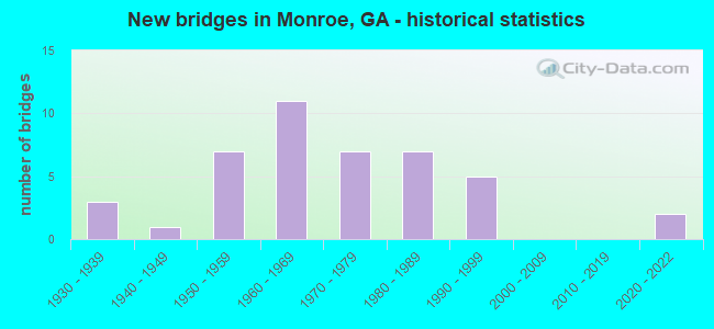
- New bridges - historical statistics
- 31930-1939
- 11940-1949
- 71950-1959
- 111960-1969
- 71970-1979
- 71980-1989
- 51990-1999
- 22020-2022


- Bridge Condition - Deck
- 11.8%Very good
- 58.8%Good
- 29.4%Satisfactory

- Bridge Condition - Superstructure
- 17.6%Very good
- 58.8%Good
- 11.8%Satisfactory
- 11.8%Fair

- Bridge Condition - Substructure
- 11.8%Very good
- 47.1%Good
- 29.4%Satisfactory
- 5.9%Fair
- 5.9%Serious

- Bridge Condition - Channel
- 20.0%Very good
- 17.1%Good
- 54.3%Satisfactory
- 8.6%Fair

- Bridge Condition - Culverts
- 61.5%Good
- 30.8%Satisfactory
- 7.7%Fair
Find on map >> Show street view
Structure Number: 2970001, Location: 2.5 MI E OF LOGANVILLE (Lat: 33.829628, Lng: -83.858978), Route carried "on" structure: US 78, Year Built: 1985, Status: Open, Structure Length: 0.70m (2.30ft), Average Daily Traffic: 23,380 (year 2012), Truck Traffic: 1%, Average Future Daily Traffic: 35,070 (year 2032), Design Load: HS 20+Mod, Features Intersected: BIG FLAT CREEK
Minimum Vertical Clearance: 30+ m (98+ ft), Kilometerpoint: 4.828, Lanes on structure: 4, Base Highway Network: Yes, Owner: State Highway Agency, Approaching Roadway Width: 18.3m (60.0ft), Skew: 12 degrees, Material/Design: Concrete, Design/Construction: Culvert, Number Of Spans In Main Unit: 2, Length of Maximum Span: 3.4m (11.2ft)
Condition: Channel: Satisfactory, Culverts: Good, Operating Rating: 55.3 metric tons, Method Used To Determine Operating Rating: Field evaluation and documented engineering judgment, Inventory Rating: 32.6 metric tons, Method Used To Determine Inventory Rating: Field evaluation and documented engineering judgment, Structural Evaluation: Better than present minimum criteria, Waterway Adequacy: Equal to present desirable criteria, Approach Roadway Alignment: Equal to present desirable criteria, Designated Inspection Frequency: Every 24 months, Inspection Date: July 2021, Bridge Improvement Cost: $139,000, Roadway Improvement Cost: $14,000, Total Project Cost: $208,000
Find on map >> Show street view
Structure Number: 2970002, Location: 3 MI E OF BETWEEN (Lat: 33.804639, Lng: -83.759094), Route carried "on" structure: US 78, Year Built: 1950, Status: Open, Structure Length: 6.89m (22.60ft), Average Daily Traffic: 19,650 (year 2012), Truck Traffic: 5%, Average Future Daily Traffic: 29,475 (year 2032), Design Load: HS 20, Features Intersected: ALCOVY RIVER
Minimum Vertical Clearance: 30+ m (98+ ft), Kilometerpoint: 16.093, Lanes on structure: 2, Base Highway Network: Yes, Owner: State Highway Agency, Approaching Roadway Width: 9.4m (30.8ft), Skew: 10 degrees, Material/Design: Steel, Design/Construction: Stringer/Multi-beam, Number Of Spans In Main Unit: 5, Length of Maximum Span: 15.2m (49.9ft), Curb or Sidewalk Widths: Left: 0.6m (2.0ft), Right: 0.6m (2.0ft), Curb-To-Curb Width: 9.0m (29.5ft), Out-to-Out Width: 10.9m (35.8ft)
Condition: Deck: Satisfactory, Superstructure: Satisfactory, Substructure: Satisfactory, Channel: Satisfactory, Operating Rating: 48.9 metric tons, Method Used To Determine Operating Rating: Load Factor (LF), Inventory Rating: 27.2 metric tons, Method Used To Determine Inventory Rating: Load Factor (LF), Structural Evaluation: Equal to present minimum criteria, Deck Geometry: High priority of corrective action, Waterway Adequacy: Equal to present desirable criteria, Approach Roadway Alignment: Equal to present desirable criteria, Length Of Structure Improvement: 13.32m (43.70ft), Designated Inspection Frequency: Every 24 months, Inspection Date: August 2021, Bridge Improvement Cost: $883,000, Roadway Improvement Cost: $88,000, Total Project Cost: $1,325,000, Deck Structure Type: Concrete Cast-file-Place
Find on map >> Show street view
Structure Number: 2970003, Location: 2 MI W OF MONROE (Lat: 33.802819, Lng: -83.749319), Route carried "on" structure: Business State highway 10, Year Built: 1964, Status: Open, Structure Length: 6.46m (21.19ft), Average Daily Traffic: 9,090 (year 2012), Truck Traffic: 1%, Average Future Daily Traffic: 13,635 (year 2032), Design Load: HS 20+Mod, Features Intersected: SR 10 EBL (US 78)
Minimum Vertical Clearance: 30+ m (98+ ft), Kilometerpoint: 0.000, Lanes on structure: 1, Lanes under structure: 2, Base Highway Network: Yes, Owner: State Highway Agency, Approaching Roadway Width: 7.0m (23.0ft), Skew: 9 degrees, Material/Design: Steel, Design/Construction: Stringer/Multi-beam, Number Of Spans In Main Unit: 3, Length of Maximum Span: 23.2m (76.1ft), Curb or Sidewalk Widths: Left: 0.6m (2.0ft), Right: 0.6m (2.0ft), Curb-To-Curb Width: 6.1m (20.0ft), Out-to-Out Width: 8.0m (26.2ft)
Condition: Deck: Good, Superstructure: Good, Substructure: Satisfactory, Operating Rating: 29.9 metric tons, Method Used To Determine Operating Rating: Load Factor (LF), Inventory Rating: 18.1 metric tons, Method Used To Determine Inventory Rating: Load Factor (LF), Structural Evaluation: Meets minimum limits, Deck Geometry: High priority of replacement, Underclear: Meets minimum limits, Approach Roadway Alignment: Equal to present desirable criteria, Designated Inspection Frequency: Every 24 months, Inspection Date: August 2021, Bridge Improvement Cost: $602,000, Roadway Improvement Cost: $60,000, Total Project Cost: $904,000, Deck Structure Type: Concrete Cast-file-Place
Find on map >> Show street view
Structure Number: 2970004, Location: IN WEST MONROE (Lat: 33.791869, Lng: -83.736139), Route carried "on" structure: Business State highway 10, Year Built: 1975, Status: Open, Structure Length: 0.79m (2.59ft), Average Daily Traffic: 16,030 (year 2012), Truck Traffic: 1%, Average Future Daily Traffic: 24,045 (year 2032), Design Load: HS 20+Mod, Features Intersected: MOUNTAIN CREEK
Minimum Vertical Clearance: 30+ m (98+ ft), Kilometerpoint: 1.609, Lanes on structure: 2, Base Highway Network: Yes, Owner: State Highway Agency, Approaching Roadway Width: 7.6m (24.9ft), Material/Design: Concrete, Design/Construction: Culvert, Number Of Spans In Main Unit: 3, Length of Maximum Span: 2.4m (7.9ft)
Condition: Channel: Very good, Culverts: Good, Operating Rating: 59.8 metric tons, Method Used To Determine Operating Rating: Load Factor (LF), Inventory Rating: 36.2 metric tons, Method Used To Determine Inventory Rating: Load Factor (LF), Structural Evaluation: Better than present minimum criteria, Waterway Adequacy: Equal to present desirable criteria, Approach Roadway Alignment: Equal to present desirable criteria, Designated Inspection Frequency: Every 24 months, Inspection Date: July 2021, Bridge Improvement Cost: $102,000, Roadway Improvement Cost: $10,000, Total Project Cost: $152,000
Find on map >> Show street view
Structure Number: 2970005, Location: 1.9 MI E OF MONROE (Lat: 33.809975, Lng: -83.687044), Route carried "on" structure: US 78, Year Built: 1978, Status: Open, Structure Length: 0.98m (3.22ft), Average Daily Traffic: 21,140 (year 2012), Truck Traffic: 10%, Average Future Daily Traffic: 31,710 (year 2032), Design Load: HS 20+Mod, Features Intersected: JACKS CREEK
Minimum Vertical Clearance: 30+ m (98+ ft), Kilometerpoint: 24.140, Lanes on structure: 4, Base Highway Network: Yes, Owner: State Highway Agency, Approaching Roadway Width: 19.2m (63.0ft), Skew: 10 degrees, Material/Design: Concrete, Design/Construction: Culvert, Number Of Spans In Main Unit: 3, Length of Maximum Span: 3.0m (9.8ft)
Condition: Channel: Very good, Culverts: Satisfactory, Structural Evaluation: Equal to present minimum criteria, Waterway Adequacy: Equal to present minimum criteria, Approach Roadway Alignment: Equal to present desirable criteria, Designated Inspection Frequency: Every 24 months, Inspection Date: August 2021, Bridge Improvement Cost: $193,000, Roadway Improvement Cost: $19,000, Total Project Cost: $290,000
Find on map >> Show street view
Structure Number: 2970008, Location: 1 MI NW OF MONROE (Lat: 33.801958, Lng: -83.740447), Route carried "on" structure: US 78, Year Built: 1964, Status: Open, Structure Length: 0.64m (2.10ft), Average Daily Traffic: 9,670 (year 2012), Truck Traffic: 1%, Average Future Daily Traffic: 14,505 (year 2032), Design Load: HS 20+Mod, Features Intersected: MOUNTAIN CREEK
Minimum Vertical Clearance: 30+ m (98+ ft), Kilometerpoint: 16.093, Lanes on structure: 4, Base Highway Network: Yes, Owner: State Highway Agency, Approaching Roadway Width: 21.9m (71.9ft), Skew: 10 degrees, Material/Design: Concrete, Design/Construction: Culvert, Number Of Spans In Main Unit: 2, Length of Maximum Span: 3.0m (9.8ft)
Condition: Channel: Very good, Culverts: Satisfactory, Structural Evaluation: Equal to present minimum criteria, Waterway Adequacy: Superior to present desirable criteria, Approach Roadway Alignment: Equal to present desirable criteria, Designated Inspection Frequency: Every 24 months, Inspection Date: August 2021, Bridge Improvement Cost: $127,000, Roadway Improvement Cost: $13,000, Total Project Cost: $190,000
Find on map >> Show street view
Structure Number: 2970009, Location: IN WEST MONROE (Lat: 33.801989, Lng: -83.736989), Route carried "on" structure: US 78, Year Built: 1964, Status: Open, Structure Length: 5.30m (17.39ft), Average Daily Traffic: 18,920 (year 2012), Truck Traffic: 8%, Average Future Daily Traffic: 28,380 (year 2032), Design Load: HS 20+Mod, Features Intersected: SR 138
Minimum Vertical Clearance: 30+ m (98+ ft), Kilometerpoint: 17.703, Lanes on structure: 2, Lanes under structure: 1, Base Highway Network: Yes, Owner: State Highway Agency, Approaching Roadway Width: 11.0m (36.1ft), Skew: 13 degrees, Material/Design: Steel continuous, Design/Construction: Stringer/Multi-beam, Number Of Spans In Main Unit: 3, Length of Maximum Span: 19.2m (63.0ft), Curb or Sidewalk Widths: Left: 0.6m (2.0ft), Right: 0.6m (2.0ft), Curb-To-Curb Width: 8.5m (27.9ft), Out-to-Out Width: 10.4m (34.1ft)
Condition: Deck: Good, Superstructure: Good, Substructure: Satisfactory, Operating Rating: 43.5 metric tons, Method Used To Determine Operating Rating: Load Factor (LF), Inventory Rating: 25.4 metric tons, Method Used To Determine Inventory Rating: Load Factor (LF), Structural Evaluation: Equal to present minimum criteria, Deck Geometry: High priority of replacement, Underclear: Equal to present minimum criteria, Approach Roadway Alignment: Equal to present desirable criteria, Designated Inspection Frequency: Every 24 months, Inspection Date: August 2021, Bridge Improvement Cost: $680,000, Roadway Improvement Cost: $68,000, Total Project Cost: $1,020,000, Deck Structure Type: Concrete Cast-file-Place
Find on map >> Show street view
Structure Number: 297001, Location: IN WEST MONROE (Lat: 33.802169, Lng: -83.736850), Route carried "on" structure: US 78, Year Built: 1964, Status: Open, Structure Length: 5.06m (16.60ft), Average Daily Traffic: 18,920 (year 2012), Truck Traffic: 8%, Average Future Daily Traffic: 28,380 (year 2032), Design Load: HS 20+Mod, Features Intersected: SR 138
Minimum Vertical Clearance: 30+ m (98+ ft), Kilometerpoint: 17.703, Lanes on structure: 2, Lanes under structure: 1, Base Highway Network: Yes, Owner: State Highway Agency, Approaching Roadway Width: 11.0m (36.1ft), Skew: 13 degrees, Material/Design: Steel continuous, Design/Construction: Stringer/Multi-beam, Number Of Spans In Main Unit: 3, Length of Maximum Span: 18.3m (60.0ft), Curb or Sidewalk Widths: Left: 0.6m (2.0ft), Right: 0.6m (2.0ft), Curb-To-Curb Width: 8.5m (27.9ft), Out-to-Out Width: 10.3m (33.8ft)
Condition: Deck: Satisfactory, Superstructure: Satisfactory, Substructure: Satisfactory, Operating Rating: 55.3 metric tons, Method Used To Determine Operating Rating: Load Factor (LF), Inventory Rating: 32.6 metric tons, Method Used To Determine Inventory Rating: Load Factor (LF), Structural Evaluation: Equal to present minimum criteria, Deck Geometry: High priority of replacement, Underclear: Equal to present minimum criteria, Approach Roadway Alignment: Equal to present desirable criteria, Designated Inspection Frequency: Every 24 months, Inspection Date: August 2021, Bridge Improvement Cost: $649,000, Roadway Improvement Cost: $65,000, Total Project Cost: $973,000, Deck Structure Type: Concrete Cast-file-Place
Find on map >> Show street view
Structure Number: 2970011, Location: IN NORTH MONROE (Lat: 33.805428, Lng: -83.709319), Route carried "on" structure: US 78, Year Built: 1964, Status: Open, Structure Length: 4.45m (14.60ft), Average Daily Traffic: 17,520 (year 2012), Truck Traffic: 1%, Average Future Daily Traffic: 26,280 (year 2032), Design Load: HS 20+Mod, Features Intersected: M-3301 E MARABLE STREET
Minimum Vertical Clearance: 30+ m (98+ ft), Kilometerpoint: 19.312, Lanes on structure: 2, Lanes under structure: 2, Base Highway Network: Yes, Owner: State Highway Agency, Approaching Roadway Width: 11.0m (36.1ft), Skew: 12 degrees, Material/Design: Steel continuous, Design/Construction: Stringer/Multi-beam, Number Of Spans In Main Unit: 3, Length of Maximum Span: 18.9m (62.0ft), Curb or Sidewalk Widths: Left: 0.6m (2.0ft), Right: 0.6m (2.0ft), Curb-To-Curb Width: 8.5m (27.9ft), Out-to-Out Width: 10.4m (34.1ft)
Condition: Deck: Good, Superstructure: Good, Substructure: Good, Operating Rating: 50.8 metric tons, Method Used To Determine Operating Rating: Load Factor (LF), Inventory Rating: 29.9 metric tons, Method Used To Determine Inventory Rating: Load Factor (LF), Structural Evaluation: Better than present minimum criteria, Deck Geometry: High priority of replacement, Underclear: Equal to present minimum criteria, Approach Roadway Alignment: Equal to present desirable criteria, Designated Inspection Frequency: Every 24 months, Inspection Date: August 2021, Bridge Improvement Cost: $570,000, Roadway Improvement Cost: $57,000, Total Project Cost: $856,000, Deck Structure Type: Concrete Cast-file-Place
Find on map >> Show street view
Structure Number: 2970012, Location: IN NORTH MONROE (Lat: 33.805589, Lng: -83.709169), Route carried "on" structure: US 78, Year Built: 1964, Status: Open, Structure Length: 4.82m (15.81ft), Average Daily Traffic: 17,520 (year 2012), Truck Traffic: 1%, Average Future Daily Traffic: 26,280 (year 2032), Design Load: HS 20+Mod, Features Intersected: M-3301 E MARABLE STREET
Minimum Vertical Clearance: 30+ m (98+ ft), Kilometerpoint: 19.312, Lanes on structure: 2, Lanes under structure: 2, Base Highway Network: Yes, Owner: State Highway Agency, Approaching Roadway Width: 11.0m (36.1ft), Skew: 12 degrees, Material/Design: Steel continuous, Design/Construction: Stringer/Multi-beam, Number Of Spans In Main Unit: 3, Length of Maximum Span: 18.9m (62.0ft), Curb or Sidewalk Widths: Left: 0.6m (2.0ft), Right: 0.6m (2.0ft), Curb-To-Curb Width: 8.5m (27.9ft), Out-to-Out Width: 10.4m (34.1ft)
Condition: Deck: Good, Superstructure: Good, Substructure: Good, Operating Rating: 47.1 metric tons, Method Used To Determine Operating Rating: Load Factor (LF), Inventory Rating: 28.1 metric tons, Method Used To Determine Inventory Rating: Load Factor (LF), Structural Evaluation: Better than present minimum criteria, Deck Geometry: High priority of replacement, Underclear: Equal to present minimum criteria, Approach Roadway Alignment: Equal to present desirable criteria, Designated Inspection Frequency: Every 24 months, Inspection Date: August 2021, Bridge Improvement Cost: $617,000, Roadway Improvement Cost: $62,000, Total Project Cost: $926,000, Deck Structure Type: Concrete Cast-file-Place
Find on map >> Show street view
Structure Number: 2970013, Location: IN NW MONROE (Lat: 33.804208, Lng: -83.696847), Route carried "on" structure: US 78, Year Built: 1964, Status: Open, Structure Length: 5.49m (18.01ft), Average Daily Traffic: 17,520 (year 2012), Truck Traffic: 1%, Average Future Daily Traffic: 26,280 (year 2032), Design Load: HS 20+Mod, Features Intersected: SR 10 BUS WBL
Minimum Vertical Clearance: 30+ m (98+ ft), Kilometerpoint: 20.921, Lanes on structure: 2, Lanes under structure: 1, Base Highway Network: Yes, Owner: State Highway Agency, Approaching Roadway Width: 11.0m (36.1ft), Skew: 13 degrees, Material/Design: Steel, Design/Construction: Stringer/Multi-beam, Number Of Spans In Main Unit: 3, Length of Maximum Span: 20.7m (67.9ft), Curb or Sidewalk Widths: Left: 0.6m (2.0ft), Right: 0.6m (2.0ft), Curb-To-Curb Width: 8.6m (28.2ft), Out-to-Out Width: 10.4m (34.1ft)
Condition: Deck: Satisfactory, Superstructure: Good, Substructure: Good, Operating Rating: 30.8 metric tons, Method Used To Determine Operating Rating: Load Factor (LF), Inventory Rating: 18.1 metric tons, Method Used To Determine Inventory Rating: Load Factor (LF), Structural Evaluation: Meets minimum limits, Deck Geometry: High priority of replacement, Underclear: Somewhat better than minimum adequacy, Approach Roadway Alignment: Equal to present desirable criteria, Designated Inspection Frequency: Every 24 months, Inspection Date: August 2021, Bridge Improvement Cost: $703,000, Roadway Improvement Cost: $70,000, Total Project Cost: $1,055,000, Deck Structure Type: Concrete Cast-file-Place
Find on map >> Show street view
Structure Number: 2970014, Location: IN NW MONROE (Lat: 33.804408, Lng: -83.696747), Route carried "on" structure: US 78, Year Built: 1964, Status: Open, Structure Length: 5.12m (16.80ft), Average Daily Traffic: 17,520 (year 2012), Truck Traffic: 1%, Average Future Daily Traffic: 26,280 (year 2032), Design Load: HS 20+Mod, Features Intersected: SR 10 BUS WBL
Minimum Vertical Clearance: 30+ m (98+ ft), Kilometerpoint: 20.921, Lanes on structure: 2, Lanes under structure: 1, Base Highway Network: Yes, Owner: State Highway Agency, Approaching Roadway Width: 11.0m (36.1ft), Skew: 13 degrees, Material/Design: Steel, Design/Construction: Stringer/Multi-beam, Number Of Spans In Main Unit: 3, Length of Maximum Span: 18.9m (62.0ft), Curb or Sidewalk Widths: Left: 0.5m (1.6ft), Right: 0.5m (1.6ft), Curb-To-Curb Width: 8.6m (28.2ft), Out-to-Out Width: 10.5m (34.4ft)
Condition: Deck: Good, Superstructure: Good, Substructure: Good, Operating Rating: 31.7 metric tons, Method Used To Determine Operating Rating: Load Factor (LF), Inventory Rating: 19.0 metric tons, Method Used To Determine Inventory Rating: Load Factor (LF), Structural Evaluation: Meets minimum limits, Deck Geometry: High priority of replacement, Underclear: Equal to present minimum criteria, Approach Roadway Alignment: Equal to present desirable criteria, Designated Inspection Frequency: Every 24 months, Inspection Date: August 2021, Bridge Improvement Cost: $656,000, Roadway Improvement Cost: $66,000, Total Project Cost: $985,000, Deck Structure Type: Concrete Cast-file-Place
Find on map >> Show street view
Structure Number: 2970017, Location: 1 MI NW OF MONROE (Lat: 33.806239, Lng: -83.722528), Route carried "on" structure: State highway 11, Year Built: 1964, Status: Open, Structure Length: 7.77m (25.49ft), Average Daily Traffic: 14,170 (year 2012), Truck Traffic: 1%, Average Future Daily Traffic: 21,255 (year 2032), Design Load: HS 20+Mod, Features Intersected: SR 10 (US 78)
Minimum Vertical Clearance: 30+ m (98+ ft), Kilometerpoint: 20.921, Lanes on structure: 4, Lanes under structure: 4, Base Highway Network: Yes, Owner: State Highway Agency, Approaching Roadway Width: 25.9m (85.0ft), Skew: 33 degrees, Material/Design: Steel, Design/Construction: Stringer/Multi-beam, Number Of Spans In Main Unit: 4, Length of Maximum Span: 20.7m (67.9ft), Curb or Sidewalk Widths: Left: 1.6m (5.2ft), Right: 1.6m (5.2ft), Curb-To-Curb Width: 17.1m (56.1ft), Out-to-Out Width: 21.9m (71.9ft)
Condition: Deck: Good, Superstructure: Good, Substructure: Good, Operating Rating: 29.9 metric tons, Method Used To Determine Operating Rating: Load Factor (LF), Inventory Rating: 17.2 metric tons, Method Used To Determine Inventory Rating: Load Factor (LF), Structural Evaluation: Meets minimum limits, Deck Geometry: Somewhat better than minimum adequacy, Underclear: High priority of corrective action, Approach Roadway Alignment: Equal to present desirable criteria, Designated Inspection Frequency: Every 24 months, Inspection Date: August 2021, Bridge Improvement Cost: $1,540,000, Roadway Improvement Cost: $154,000, Total Project Cost: $2,310,000, Deck Structure Type: Concrete Cast-file-Place
Find on map >> Show street view
Structure Number: 2970018, Location: 4.75 MI N OF MONROE (Lat: 33.857878, Lng: -83.721519), Route carried "on" structure: State highway 11, Year Built: 1934, Status: Open, Structure Length: 1.13m (3.71ft), Average Daily Traffic: 9,410 (year 2012), Truck Traffic: 10%, Average Future Daily Traffic: 14,115 (year 2032), Design Load: H 15, Features Intersected: SHOALS CREEK
Minimum Vertical Clearance: 30+ m (98+ ft), Kilometerpoint: 27.359, Lanes on structure: 2, Base Highway Network: Yes, Owner: State Highway Agency, Approaching Roadway Width: 8.5m (27.9ft), Material/Design: Concrete, Design/Construction: Culvert, Number Of Spans In Main Unit: 4, Length of Maximum Span: 2.7m (8.9ft)
Condition: Channel: Satisfactory, Culverts: Good, Operating Rating: 39.9 metric tons, Method Used To Determine Operating Rating: Load Factor (LF), Inventory Rating: 23.5 metric tons, Method Used To Determine Inventory Rating: Load Factor (LF), Structural Evaluation: Somewhat better than minimum adequacy, Waterway Adequacy: Equal to present minimum criteria, Approach Roadway Alignment: Equal to present desirable criteria, Length Of Structure Improvement: 7.62m (25.00ft), Designated Inspection Frequency: Every 24 months, Inspection Date: August 2021, Bridge Improvement Cost: $145,000, Roadway Improvement Cost: $14,000, Total Project Cost: $217,000
Find on map >> Show street view
Structure Number: 297002, Location: 1 MI NW OF LOGANVILLE (Lat: 33.848489, Lng: -83.894700), Route carried "on" structure: State highway 81, Year Built: 1950, Status: Open, Structure Length: 0.73m (2.40ft), Average Daily Traffic: 9,870 (year 2012), Truck Traffic: 1%, Average Future Daily Traffic: 14,805 (year 2032), Design Load: H 15, Features Intersected: BIG FLAT CREEK
Minimum Vertical Clearance: 30+ m (98+ ft), Kilometerpoint: 19.312, Lanes on structure: 2, Base Highway Network: Yes, Owner: State Highway Agency, Approaching Roadway Width: 8.2m (26.9ft), Skew: 2 degrees, Material/Design: Concrete, Design/Construction: Culvert, Number Of Spans In Main Unit: 2, Length of Maximum Span: 3.4m (11.2ft)
Condition: Channel: Satisfactory, Culverts: Good, Operating Rating: 59.8 metric tons, Method Used To Determine Operating Rating: Load Factor (LF), Inventory Rating: 36.2 metric tons, Method Used To Determine Inventory Rating: Load Factor (LF), Structural Evaluation: Better than present minimum criteria, Waterway Adequacy: Equal to present desirable criteria, Approach Roadway Alignment: Equal to present desirable criteria, Designated Inspection Frequency: Every 24 months, Inspection Date: August 2021, Bridge Improvement Cost: $94,000, Roadway Improvement Cost: $9,000, Total Project Cost: $141,000
Find on map >> Show street view
Structure Number: 2970025, Location: 2.9 MI NW OF GOOD HOPE (Lat: 33.796558, Lng: -83.654989), Route carried "on" structure: State highway 83, Year Built: 1948, Status: Open, Structure Length: 0.70m (2.30ft), Average Daily Traffic: 3,700 (year 2012), Truck Traffic: 1%, Average Future Daily Traffic: 5,550 (year 2032), Design Load: H 15, Features Intersected: GRUBBY CREEK
Minimum Vertical Clearance: 30+ m (98+ ft), Kilometerpoint: 11.265, Lanes on structure: 2, Base Highway Network: Yes, Owner: State Highway Agency, Approaching Roadway Width: 7.3m (24.0ft), Material/Design: Concrete, Design/Construction: Culvert, Number Of Spans In Main Unit: 3, Length of Maximum Span: 2.1m (6.9ft)
Condition: Channel: Fair, Culverts: Satisfactory, Operating Rating: 41.7 metric tons, Method Used To Determine Operating Rating: Field evaluation and documented engineering judgment, Inventory Rating: 24.4 metric tons, Method Used To Determine Inventory Rating: Field evaluation and documented engineering judgment, Structural Evaluation: Equal to present minimum criteria, Waterway Adequacy: Equal to present minimum criteria, Approach Roadway Alignment: Equal to present desirable criteria, Designated Inspection Frequency: Every 24 months, Inspection Date: August 2021, Bridge Improvement Cost: $90,000, Roadway Improvement Cost: $9,000, Total Project Cost: $135,000
Find on map >> Show street view
Structure Number: 2970027, Location: 4.5 MI NE OF WALNUT GROVE (Lat: 33.775739, Lng: -83.787450), Route carried "on" structure: State highway 138, Year Built: 1958, Year Reconstructed: 2000, Status: Open, Structure Length: 1.13m (3.71ft), Average Daily Traffic: 15,100 (year 2012), Truck Traffic: 1%, Average Future Daily Traffic: 22,650 (year 2032), Design Load: H 15, Features Intersected: LITTLE FLAT CREEK
Minimum Vertical Clearance: 30+ m (98+ ft), Kilometerpoint: 11.265, Lanes on structure: 3, Base Highway Network: Yes, Owner: State Highway Agency, Approaching Roadway Width: 12.2m (40.0ft), Skew: 3 degrees, Material/Design: Concrete, Design/Construction: Culvert, Number Of Spans In Main Unit: 3, Length of Maximum Span: 3.7m (12.1ft)
Condition: Channel: Good, Culverts: Good, Operating Rating: 41.7 metric tons, Method Used To Determine Operating Rating: Field evaluation and documented engineering judgment, Inventory Rating: 24.4 metric tons, Method Used To Determine Inventory Rating: Field evaluation and documented engineering judgment, Structural Evaluation: Equal to present minimum criteria, Waterway Adequacy: Equal to present desirable criteria, Approach Roadway Alignment: Equal to present desirable criteria, Designated Inspection Frequency: Every 24 months, Inspection Date: July 2021, Bridge Improvement Cost: $184,000, Roadway Improvement Cost: $18,000, Total Project Cost: $276,000
Find on map >> Show street view
Structure Number: 2970028, Location: 2 MI SW OF MONROE (Lat: 33.788208, Lng: -83.751619), Route carried "on" structure: State highway 138, Year Built: 1958, Status: Open, Structure Length: 9.63m (31.59ft), Average Daily Traffic: 15,340 (year 2012), Truck Traffic: 1%, Average Future Daily Traffic: 23,010 (year 2032), Design Load: HS 20, Features Intersected: ALCOVY RIVER
Minimum Vertical Clearance: 30+ m (98+ ft), Kilometerpoint: 14.484, Lanes on structure: 2, Base Highway Network: Yes, Owner: State Highway Agency, Approaching Roadway Width: 8.8m (28.9ft), Skew: 4 degrees, Material/Design: Concrete, Design/Construction: Tee Beam, Number Of Spans In Main Unit: 9, Length of Maximum Span: 11.3m (37.1ft), Curb or Sidewalk Widths: Left: 0.6m (2.0ft), Right: 0.6m (2.0ft), Curb-To-Curb Width: 8.5m (27.9ft), Out-to-Out Width: 10.4m (34.1ft)
Condition: Deck: Satisfactory, Superstructure: Good, Substructure: Satisfactory, Channel: Satisfactory, Operating Rating: 39.0 metric tons, Method Used To Determine Operating Rating: Load Factor (LF), Inventory Rating: 22.6 metric tons, Method Used To Determine Inventory Rating: Load Factor (LF), Structural Evaluation: Somewhat better than minimum adequacy, Deck Geometry: Meets minimum limits, Waterway Adequacy: Equal to present desirable criteria, Approach Roadway Alignment: Equal to present desirable criteria, Length Of Structure Improvement: 16.06m (52.69ft), Designated Inspection Frequency: Every 24 months, Inspection Date: July 2021, Bridge Improvement Cost: $1,235,000, Roadway Improvement Cost: $123,000, Total Project Cost: $1,852,000, Deck Structure Type: Concrete Cast-file-Place
Find on map >> Show street view
Structure Number: 2970029, Location: 1 MI NW OF MONROE (Lat: 33.798219, Lng: -83.740028), Route carried "on" structure: State highway 138, Year Built: 1964, Status: Open, Structure Length: 0.88m (2.89ft), Average Daily Traffic: 15,040 (year 2012), Truck Traffic: 1%, Average Future Daily Traffic: 22,560 (year 2032), Design Load: HS 20, Features Intersected: MOUNTAIN CREEK
Minimum Vertical Clearance: 30+ m (98+ ft), Kilometerpoint: 16.093, Lanes on structure: 2, Base Highway Network: Yes, Owner: State Highway Agency, Approaching Roadway Width: 9.1m (29.9ft), Skew: 4 degrees, Material/Design: Concrete, Design/Construction: Culvert, Number Of Spans In Main Unit: 2, Length of Maximum Span: 4.3m (14.1ft)
Condition: Channel: Satisfactory, Culverts: Satisfactory, Operating Rating: 89.8 metric tons, Method Used To Determine Operating Rating: Field evaluation and documented engineering judgment, Inventory Rating: 89.8 metric tons, Method Used To Determine Inventory Rating: Field evaluation and documented engineering judgment, Structural Evaluation: Equal to present minimum criteria, Waterway Adequacy: Superior to present desirable criteria, Approach Roadway Alignment: Equal to present desirable criteria, Designated Inspection Frequency: Every 24 months, Inspection Date: July 2021, Bridge Improvement Cost: $113,000, Roadway Improvement Cost: $11,000, Total Project Cost: $170,000
Find on map >> Show street view
Structure Number: 2970034, Location: 3 MI NE OF JERSEY (Lat: 33.743478, Lng: -83.754419), Route carried "on" structure: County highway 920, Year Built: 1976, Status: Open, Structure Length: 8.53m (27.99ft), Average Daily Traffic: 2,030 (year 2012), Truck Traffic: 1%, Average Future Daily Traffic: 3,045 (year 2032), Design Load: HS 20+Mod, Features Intersected: ALCOVY RIVER, Facility Carried by Structure: MONROE JERSEY RD
Minimum Vertical Clearance: 30+ m (98+ ft), Kilometerpoint: 11.265, Lanes on structure: 2, Base Highway Network: Yes, Owner: County Highway Agency, Approaching Roadway Width: 7.3m (24.0ft), Skew: 2 degrees, Material/Design: Concrete, Design/Construction: Tee Beam, Number Of Spans In Main Unit: 7, Length of Maximum Span: 12.2m (40.0ft), Curb-To-Curb Width: 13.0m (42.7ft), Out-to-Out Width: 14.2m (46.6ft)
Condition: Deck: Good, Superstructure: Good, Substructure: Good, Channel: Satisfactory, Operating Rating: 35.3 metric tons, Method Used To Determine Operating Rating: Load Factor (LF), Inventory Rating: 20.8 metric tons, Method Used To Determine Inventory Rating: Load Factor (LF), Structural Evaluation: Somewhat better than minimum adequacy, Deck Geometry: Equal to present minimum criteria, Waterway Adequacy: Equal to present desirable criteria, Approach Roadway Alignment: Equal to present desirable criteria, Designated Inspection Frequency: Every 24 months, Underwater Inspection Frequency: Every 60 months, Inspection Date: July 2021, Underwater Inspection Date: April 2020, Deck Structure Type: Concrete Cast-file-Place
Find on map >> Show street view
Structure Number: 2970035, Location: 3.25 MI S OF MONROE (Lat: 33.749678, Lng: -83.736147), Route carried "on" structure: County highway 920, Year Built: 1975, Status: Open, Structure Length: 0.98m (3.22ft), Average Daily Traffic: 2,030 (year 2012), Truck Traffic: 1%, Average Future Daily Traffic: 3,045 (year 2032), Design Load: HS 20, Features Intersected: MOUNTAIN CREEK, Facility Carried by Structure: MONROE JERSEY RD
Minimum Vertical Clearance: 30+ m (98+ ft), Kilometerpoint: 12.875, Lanes on structure: 2, Base Highway Network: Yes, Owner: County Highway Agency, Approaching Roadway Width: 7.3m (24.0ft), Material/Design: Concrete, Design/Construction: Culvert, Number Of Spans In Main Unit: 3, Length of Maximum Span: 3.0m (9.8ft)
Condition: Channel: Good, Culverts: Good, Operating Rating: 41.7 metric tons, Method Used To Determine Operating Rating: Field evaluation and documented engineering judgment, Inventory Rating: 24.4 metric tons, Method Used To Determine Inventory Rating: Field evaluation and documented engineering judgment, Structural Evaluation: Equal to present minimum criteria, Waterway Adequacy: Equal to present desirable criteria, Approach Roadway Alignment: Equal to present desirable criteria, Designated Inspection Frequency: Every 24 months, Underwater Inspection Frequency: Every 60 months, Inspection Date: July 2021, Underwater Inspection Date: April 2020
Find on map >> Show street view
Structure Number: 2970036, Location: 3 MI E OF MONROE (Lat: 33.806817, Lng: -83.663600), Route carried "on" structure: County highway 1049, Year Built: 1954, Status: Open, Structure Length: 1.34m (4.40ft), Average Daily Traffic: 1,040 (year 2012), Truck Traffic: 1%, Average Future Daily Traffic: 1,560 (year 2032), Design Load: H 15, Features Intersected: JACKS CREEK, Facility Carried by Structure: SNOWS MILL ROAD
Minimum Vertical Clearance: 30+ m (98+ ft), Kilometerpoint: 1.609, Lanes on structure: 2, Base Highway Network: Yes, Owner: County Highway Agency, Approaching Roadway Width: 6.7m (22.0ft), Material/Design: Concrete, Design/Construction: Culvert, Number Of Spans In Main Unit: 4, Length of Maximum Span: 3.0m (9.8ft)
Condition: Channel: Satisfactory, Culverts: Satisfactory, Operating Rating: 41.7 metric tons, Method Used To Determine Operating Rating: Field evaluation and documented engineering judgment, Inventory Rating: 24.4 metric tons, Method Used To Determine Inventory Rating: Field evaluation and documented engineering judgment, Structural Evaluation: Equal to present minimum criteria, Waterway Adequacy: Equal to present desirable criteria, Approach Roadway Alignment: Equal to present desirable criteria, Designated Inspection Frequency: Every 24 months, Inspection Date: August 2021, Bridge Improvement Cost: $172,000, Roadway Improvement Cost: $17,000, Total Project Cost: $258,000
Find on map >> Show street view
Structure Number: 2970037, Location: 4.5 MI E OF MONROE (Lat: 33.814108, Lng: -83.639908), Route carried "on" structure: County highway 1049, Year Built: 1954, Status: Open, Structure Length: 0.64m (2.10ft), Average Daily Traffic: 840 (year 2012), Truck Traffic: 1%, Average Future Daily Traffic: 1,260 (year 2032), Design Load: H 15, Features Intersected: JACKS CREEK TRIB., Facility Carried by Structure: SNOWS MILL ROAD
Minimum Vertical Clearance: 30+ m (98+ ft), Kilometerpoint: 3.219, Lanes on structure: 2, Base Highway Network: Yes, Owner: County Highway Agency, Approaching Roadway Width: 6.4m (21.0ft), Material/Design: Concrete, Design/Construction: Culvert, Number Of Spans In Main Unit: 2, Length of Maximum Span: 3.0m (9.8ft)
Condition: Channel: Satisfactory, Culverts: Good, Operating Rating: 41.7 metric tons, Method Used To Determine Operating Rating: Field evaluation and documented engineering judgment, Inventory Rating: 24.4 metric tons, Method Used To Determine Inventory Rating: Field evaluation and documented engineering judgment, Structural Evaluation: Equal to present minimum criteria, Waterway Adequacy: Equal to present desirable criteria, Approach Roadway Alignment: Equal to present desirable criteria, Designated Inspection Frequency: Every 24 months, Underwater Inspection Frequency: Every 60 months, Inspection Date: July 2021, Underwater Inspection Date: April 2020
Find on map >> Show street view
Structure Number: 2970047, Location: 2.3 MI N OF MONROE (Lat: 33.823119, Lng: -83.699458), Route carried "on" structure: County highway 1434, Year Built: 1938, Status: Open, Structure Length: 0.70m (2.30ft), Average Daily Traffic: 1,710 (year 2012), Truck Traffic: 1%, Average Future Daily Traffic: 2,565 (year 2032), Design Load: H 15, Features Intersected: JACKS CREEK, Facility Carried by Structure: GRATIS ROAD
Minimum Vertical Clearance: 30+ m (98+ ft), Kilometerpoint: 0.000, Lanes on structure: 2, Base Highway Network: Yes, Owner: County Highway Agency, Approaching Roadway Width: 6.1m (20.0ft), Material/Design: Steel, Design/Construction: Culvert, Number Of Spans In Main Unit: 2, Length of Maximum Span: 3.0m (9.8ft)
Condition: Channel: Satisfactory, Culverts: Good, Operating Rating: 41.7 metric tons, Method Used To Determine Operating Rating: Field evaluation and documented engineering judgment, Inventory Rating: 24.4 metric tons, Method Used To Determine Inventory Rating: Field evaluation and documented engineering judgment, Structural Evaluation: Equal to present minimum criteria, Waterway Adequacy: Equal to present desirable criteria, Approach Roadway Alignment: Equal to present desirable criteria, Designated Inspection Frequency: Every 24 months, Inspection Date: August 2021, Bridge Improvement Cost: $90,000, Roadway Improvement Cost: $9,000, Total Project Cost: $135,000
Find on map >> Show street view
Structure Number: 2970048, Location: .75 MI SW OF GRATIS (Lat: 33.877858, Lng: -83.669739), Route carried "on" structure: County highway 1434, Year Built: 1989, Status: Open, Structure Length: 0.91m (2.99ft), Average Daily Traffic: 1,310 (year 2012), Truck Traffic: 1%, Average Future Daily Traffic: 1,965 (year 2032), Design Load: HS 20+Mod, Features Intersected: SHOALS CREEK, Facility Carried by Structure: GRATIS ROAD
Minimum Vertical Clearance: 30+ m (98+ ft), Kilometerpoint: 8.047, Lanes on structure: 2, Base Highway Network: Yes, Owner: County Highway Agency, Approaching Roadway Width: 6.1m (20.0ft), Skew: 1 degrees, Material/Design: Concrete, Design/Construction: Culvert, Number Of Spans In Main Unit: 3, Length of Maximum Span: 2.7m (8.9ft)
Condition: Channel: Satisfactory, Culverts: Good, Operating Rating: 55.3 metric tons, Method Used To Determine Operating Rating: Field evaluation and documented engineering judgment, Inventory Rating: 32.6 metric tons, Method Used To Determine Inventory Rating: Field evaluation and documented engineering judgment, Structural Evaluation: Better than present minimum criteria, Waterway Adequacy: Equal to present desirable criteria, Approach Roadway Alignment: Equal to present desirable criteria, Designated Inspection Frequency: Every 24 months, Inspection Date: August 2021, Bridge Improvement Cost: $117,000, Roadway Improvement Cost: $12,000, Total Project Cost: $176,000
Find on map >> Show street view
Structure Number: 297005, Location: 1 MI N OF MONROE (Lat: 33.813358, Lng: -83.708658), Route carried "on" structure: City street 3301, Year Built: 1938, Status: Open, Structure Length: 0.82m (2.69ft), Average Daily Traffic: 5,120 (year 2012), Truck Traffic: 1%, Average Future Daily Traffic: 7,680 (year 2032), Design Load: H 15, Features Intersected: JACKS CREEK TRIB., Facility Carried by Structure: MARABLE STREET
Minimum Vertical Clearance: 30+ m (98+ ft), Kilometerpoint: 1.609, Lanes on structure: 2, Base Highway Network: Yes, Owner: County Highway Agency, Approaching Roadway Width: 6.7m (22.0ft), Material/Design: Steel, Design/Construction: Culvert, Number Of Spans In Main Unit: 2, Length of Maximum Span: 3.7m (12.1ft)
Condition: Channel: Very good, Culverts: Satisfactory, Operating Rating: 41.7 metric tons, Method Used To Determine Operating Rating: Field evaluation and documented engineering judgment, Inventory Rating: 24.4 metric tons, Method Used To Determine Inventory Rating: Field evaluation and documented engineering judgment, Structural Evaluation: Equal to present minimum criteria, Waterway Adequacy: Equal to present desirable criteria, Approach Roadway Alignment: Equal to present desirable criteria, Designated Inspection Frequency: Every 24 months, Inspection Date: August 2021, Bridge Improvement Cost: $105,000, Roadway Improvement Cost: $11,000, Total Project Cost: $158,000
Find on map >> Show street view
Structure Number: 2970051, Location: 3 MI E OF BETWEEN (Lat: 33.804811, Lng: -83.759011), Route carried "on" structure: US 78, Year Built: 1986, Status: Open, Structure Length: 7.50m (24.61ft), Average Daily Traffic: 19,650 (year 2012), Truck Traffic: 5%, Average Future Daily Traffic: 29,475 (year 2032), Design Load: HS 20+Mod, Features Intersected: ALCOVY RIVER
Minimum Vertical Clearance: 30+ m (98+ ft), Kilometerpoint: 16.093, Lanes on structure: 2, Base Highway Network: Yes, Owner: State Highway Agency, Approaching Roadway Width: 9.1m (29.9ft), Skew: 12 degrees, Material/Design: Prestressed concrete, Design/Construction: Stringer/Multi-beam, Number Of Spans In Main Unit: 5, Length of Maximum Span: 16.5m (54.1ft), Curb-To-Curb Width: 11.6m (38.1ft), Out-to-Out Width: 12.5m (41.0ft)
Condition: Deck: Good, Superstructure: Very good, Substructure: Good, Channel: Satisfactory, Operating Rating: 61.6 metric tons, Method Used To Determine Operating Rating: Load Factor (LF), Inventory Rating: 36.2 metric tons, Method Used To Determine Inventory Rating: Load Factor (LF), Structural Evaluation: Better than present minimum criteria, Deck Geometry: Better than present minimum criteria, Waterway Adequacy: Equal to present desirable criteria, Approach Roadway Alignment: Equal to present desirable criteria, Designated Inspection Frequency: Every 24 months, Underwater Inspection Frequency: Every 60 months, Inspection Date: August 2021, Underwater Inspection Date: April 2020, Deck Structure Type: Concrete Cast-file-Place
Find on map >> Show street view
Structure Number: 2975003, Location: 2.3 MI SW OF GRATIS (Lat: 33.862919, Lng: -83.695589), Route carried "on" structure: County highway 3, Year Built: 1989, Status: Open, Structure Length: 0.98m (3.22ft), Average Daily Traffic: 490 (year 2012), Truck Traffic: 1%, Average Future Daily Traffic: 735 (year 2032), Design Load: HS 20+Mod, Features Intersected: SHOALS CREEK, Facility Carried by Structure: JOHN STOWE ROAD
Minimum Vertical Clearance: 30+ m (98+ ft), Kilometerpoint: 4.828, Lanes on structure: 2, Base Highway Network: Yes, Owner: County Highway Agency, Approaching Roadway Width: 5.8m (19.0ft), Material/Design: Concrete, Design/Construction: Culvert, Number Of Spans In Main Unit: 3, Length of Maximum Span: 3.0m (9.8ft)
Condition: Channel: Good, Culverts: Good, Operating Rating: 55.3 metric tons, Method Used To Determine Operating Rating: Field evaluation and documented engineering judgment, Inventory Rating: 32.6 metric tons, Method Used To Determine Inventory Rating: Field evaluation and documented engineering judgment, Structural Evaluation: Better than present minimum criteria, Waterway Adequacy: Equal to present desirable criteria, Approach Roadway Alignment: Equal to present desirable criteria, Designated Inspection Frequency: Every 24 months, Inspection Date: August 2021, Bridge Improvement Cost: $125,000, Roadway Improvement Cost: $13,000, Total Project Cost: $188,000
Find on map >> Show street view
Structure Number: 2975007, Location: 3.5 MI SE OF BOLD SPRINGS (Lat: 33.856997, Lng: -83.775450), Route carried "on" structure: County highway 20, Year Built: 1959, Status: Posted for load, Structure Length: 1.22m (4.00ft), Average Daily Traffic: 60 (year 2012), Truck Traffic: 1%, Average Future Daily Traffic: 90 (year 2032), Design Load: H 15, Features Intersected: BEAVERDAM CREEK, Facility Carried by Structure: DEWEY HOGAN ROAD
Minimum Vertical Clearance: 30+ m (98+ ft), Kilometerpoint: 3.219, Lanes on structure: 2, Base Highway Network: Yes, Owner: County Highway Agency, Approaching Roadway Width: 5.2m (17.1ft), Material/Design: Steel, Design/Construction: Stringer/Multi-beam, Number Of Spans In Main Unit: 1, Length of Maximum Span: 12.2m (40.0ft), Curb-To-Curb Width: 5.9m (19.4ft), Out-to-Out Width: 6.1m (20.0ft)
Condition: Deck: Satisfactory, Superstructure: Fair, Substructure: Serious, Channel: Satisfactory, Operating Rating: 20.8 metric tons, Method Used To Determine Operating Rating: Load Factor (LF), Inventory Rating: 10.8 metric tons, Method Used To Determine Inventory Rating: Load Factor (LF), Structural Evaluation: High priority of corrective action, Deck Geometry: Meets minimum limits, Waterway Adequacy: Meets minimum limits, Approach Roadway Alignment: Meets minimum limits, Bridge Posting: Required (Relationship of Operating Rating to Maximum Legal Load: 30.0 - 39.9% below), Length Of Structure Improvement: 42.67m (139.99ft), Designated Inspection Frequency: Every 24 months, Underwater Inspection Frequency: Every 12 months, Inspection Date: August 2021, Underwater Inspection Date: April 2021, Bridge Improvement Cost: $87,000, Roadway Improvement Cost: $149,000, Total Project Cost: $265,000, Deck Structure Type: Concrete Cast-file-Place
Find on map >> Show street view
Structure Number: 297501, Location: 2 MI NE OF MONROE (Lat: 33.818058, Lng: -83.695119), Route carried "on" structure: County highway 25, Year Built: 1985, Status: Open, Structure Length: 1.83m (6.00ft), Average Daily Traffic: 250 (year 2012), Truck Traffic: 1%, Average Future Daily Traffic: 375 (year 2032), Design Load: HS 20+Mod, Features Intersected: JACKS CREEK, Facility Carried by Structure: OLD ATHENS HWY
Minimum Vertical Clearance: 30+ m (98+ ft), Kilometerpoint: 1.609, Lanes on structure: 2, Base Highway Network: Yes, Owner: County Highway Agency, Approaching Roadway Width: 6.4m (21.0ft), Skew: 4 degrees, Material/Design: Concrete, Design/Construction: Culvert, Number Of Spans In Main Unit: 4, Length of Maximum Span: 4.3m (14.1ft)
Condition: Channel: Good, Culverts: Satisfactory, Operating Rating: 55.3 metric tons, Method Used To Determine Operating Rating: Field evaluation and documented engineering judgment, Inventory Rating: 32.6 metric tons, Method Used To Determine Inventory Rating: Field evaluation and documented engineering judgment, Structural Evaluation: Equal to present minimum criteria, Waterway Adequacy: Equal to present desirable criteria, Approach Roadway Alignment: Better than present minimum criteria, Designated Inspection Frequency: Every 24 months, Inspection Date: August 2021, Bridge Improvement Cost: $234,000, Roadway Improvement Cost: $23,000, Total Project Cost: $352,000
Find on map >> Show street view
Structure Number: 297503, Location: 2.3 MI SW OF MONROE (Lat: 33.766469, Lng: -83.735769), Route carried "on" structure: County highway 170, Year Built: 1993, Status: Open, Structure Length: 1.01m (3.31ft), Average Daily Traffic: 830 (year 2012), Truck Traffic: 1%, Average Future Daily Traffic: 1,245 (year 2032), Features Intersected: MOUNTAIN CREEK, Facility Carried by Structure: AMMONS BRIDGE RD
Minimum Vertical Clearance: 30+ m (98+ ft), Kilometerpoint: 4.828, Lanes on structure: 2, Base Highway Network: Yes, Owner: County Highway Agency, Approaching Roadway Width: 6.4m (21.0ft), Skew: 1 degrees, Material/Design: Concrete, Design/Construction: Culvert, Number Of Spans In Main Unit: 3, Length of Maximum Span: 3.0m (9.8ft)
Condition: Channel: Good, Culverts: Fair, Operating Rating: 55.3 metric tons, Method Used To Determine Operating Rating: Field evaluation and documented engineering judgment, Inventory Rating: 32.6 metric tons, Method Used To Determine Inventory Rating: Field evaluation and documented engineering judgment, Structural Evaluation: Somewhat better than minimum adequacy, Waterway Adequacy: Equal to present desirable criteria, Approach Roadway Alignment: Equal to present desirable criteria, Designated Inspection Frequency: Every 24 months, Inspection Date: July 2021, Bridge Improvement Cost: $129,000, Roadway Improvement Cost: $13,000, Total Project Cost: $193,000
Find on map >> Show street view
Structure Number: 2975031, Location: 1 MI SW OF MONROE (Lat: 33.784256, Lng: -83.735786), Route carried "on" structure: County highway 172, Year Built: 1970, Status: Open, Structure Length: 1.04m (3.41ft), Average Daily Traffic: 1,760 (year 2012), Truck Traffic: 1%, Average Future Daily Traffic: 2,640 (year 2032), Design Load: H 15, Features Intersected: MOUNTAIN CREEK, Facility Carried by Structure: MCDANIEL STREET
Minimum Vertical Clearance: 30+ m (98+ ft), Kilometerpoint: 0.000, Lanes on structure: 2, Base Highway Network: Yes, Owner: County Highway Agency, Approaching Roadway Width: 6.7m (22.0ft), Material/Design: Steel, Design/Construction: Culvert, Number Of Spans In Main Unit: 3, Length of Maximum Span: 3.0m (9.8ft)
Condition: Channel: Fair, Culverts: Satisfactory, Operating Rating: 39.0 metric tons, Method Used To Determine Operating Rating: Field evaluation and documented engineering judgment, Inventory Rating: 24.4 metric tons, Method Used To Determine Inventory Rating: Field evaluation and documented engineering judgment, Structural Evaluation: Equal to present minimum criteria, Waterway Adequacy: Equal to present desirable criteria, Approach Roadway Alignment: Better than present minimum criteria, Designated Inspection Frequency: Every 24 months, Inspection Date: July 2021, Bridge Improvement Cost: $133,000, Roadway Improvement Cost: $13,000, Total Project Cost: $199,000
Find on map >> Show street view
Structure Number: 2975033, Location: 3.3 MI S OF MONROE (Lat: 33.746869, Lng: -83.729669), Route carried "on" structure: County highway 179, Year Built: 1990, Status: Open, Structure Length: 1.01m (3.31ft), Average Daily Traffic: 490 (year 2012), Truck Traffic: 1%, Average Future Daily Traffic: 735 (year 2032), Design Load: HS 20+Mod, Features Intersected: MOUNTAIN CREEK TRIB., Facility Carried by Structure: DEAN HILL ROAD
Minimum Vertical Clearance: 30+ m (98+ ft), Kilometerpoint: 0.000, Lanes on structure: 2, Base Highway Network: Yes, Owner: County Highway Agency, Approaching Roadway Width: 5.5m (18.0ft), Skew: 1 degrees, Material/Design: Concrete, Design/Construction: Culvert, Number Of Spans In Main Unit: 3, Length of Maximum Span: 3.0m (9.8ft)
Condition: Channel: Satisfactory, Culverts: Good, Operating Rating: 55.3 metric tons, Method Used To Determine Operating Rating: Field evaluation and documented engineering judgment, Inventory Rating: 32.6 metric tons, Method Used To Determine Inventory Rating: Field evaluation and documented engineering judgment, Structural Evaluation: Better than present minimum criteria, Waterway Adequacy: Equal to present desirable criteria, Approach Roadway Alignment: Equal to present desirable criteria, Designated Inspection Frequency: Every 24 months, Inspection Date: July 2021, Bridge Improvement Cost: $129,000, Roadway Improvement Cost: $13,000, Total Project Cost: $193,000
Find on map >> Show street view
Structure Number: 2975047, Location: 1.3 MI SW OF GRATIS (Lat: 33.873058, Lng: -83.681208), Route carried "on" structure: County highway 261, Year Built: 1989, Status: Open, Structure Length: 1.31m (4.30ft), Average Daily Traffic: 490 (year 2012), Truck Traffic: 1%, Average Future Daily Traffic: 735 (year 2032), Design Load: H 15, Features Intersected: SHOALS CREEK, Facility Carried by Structure: DRY POND ROAD
Minimum Vertical Clearance: 30+ m (98+ ft), Kilometerpoint: 3.219, Lanes on structure: 2, Base Highway Network: Yes, Owner: County Highway Agency, Approaching Roadway Width: 6.4m (21.0ft), Material/Design: Steel, Design/Construction: Culvert, Number Of Spans In Main Unit: 4, Length of Maximum Span: 2.4m (7.9ft)
Condition: Channel: Satisfactory, Culverts: Good, Operating Rating: 41.7 metric tons, Method Used To Determine Operating Rating: Field evaluation and documented engineering judgment, Inventory Rating: 24.4 metric tons, Method Used To Determine Inventory Rating: Field evaluation and documented engineering judgment, Structural Evaluation: Equal to present minimum criteria, Waterway Adequacy: Equal to present desirable criteria, Approach Roadway Alignment: Better than present minimum criteria, Designated Inspection Frequency: Every 24 months, Inspection Date: August 2021, Bridge Improvement Cost: $168,000, Roadway Improvement Cost: $17,000, Total Project Cost: $252,000
Find on map >> Show street view
Structure Number: 2975048, Location: 2.5 MI NE OF BETWEEN (Lat: 33.843008, Lng: -83.775439), Route carried "on" structure: County highway 271, Year Built: 1993, Status: Open, Structure Length: 2.53m (8.30ft), Average Daily Traffic: 490 (year 2012), Truck Traffic: 1%, Average Future Daily Traffic: 735 (year 2032), Design Load: HS 20+Mod, Features Intersected: BEAVERDAM CREEK, Facility Carried by Structure: DOUBLE SPRINGS RD
Minimum Vertical Clearance: 30+ m (98+ ft), Kilometerpoint: 4.828, Lanes on structure: 2, Base Highway Network: Yes, Owner: County Highway Agency, Approaching Roadway Width: 7.3m (24.0ft), Skew: 4 degrees, Material/Design: Concrete, Design/Construction: Culvert, Number Of Spans In Main Unit: 5, Length of Maximum Span: 4.9m (16.1ft)
Condition: Channel: Very good, Culverts: Good, Structural Evaluation: Better than present minimum criteria, Waterway Adequacy: Equal to present desirable criteria, Approach Roadway Alignment: Equal to present desirable criteria, Designated Inspection Frequency: Every 24 months, Underwater Inspection Frequency: Every 60 months, Inspection Date: August 2021, Underwater Inspection Date: April 2020
Find on map >> Show street view
Structure Number: 2975061, Location: 1.2 MI S OF GRATIS (Lat: 33.865297, Lng: -83.661100), Route carried "on" structure: County highway 336, Year Built: 1963, Status: Open, Structure Length: 1.01m (3.31ft), Average Daily Traffic: 490 (year 2012), Truck Traffic: 1%, Average Future Daily Traffic: 735 (year 2032), Design Load: H 15, Features Intersected: SHOALS CREEK, Facility Carried by Structure: MOUNT VERNON RD
Minimum Vertical Clearance: 30+ m (98+ ft), Kilometerpoint: 1.609, Lanes on structure: 2, Base Highway Network: Yes, Owner: County Highway Agency, Approaching Roadway Width: 6.1m (20.0ft), Skew: 1 degrees, Material/Design: Concrete, Design/Construction: Culvert, Number Of Spans In Main Unit: 3, Length of Maximum Span: 3.0m (9.8ft)
Condition: Channel: Satisfactory, Culverts: Good, Operating Rating: 41.7 metric tons, Method Used To Determine Operating Rating: Field evaluation and documented engineering judgment, Inventory Rating: 24.4 metric tons, Method Used To Determine Inventory Rating: Field evaluation and documented engineering judgment, Structural Evaluation: Equal to present minimum criteria, Waterway Adequacy: Equal to present desirable criteria, Approach Roadway Alignment: Equal to present desirable criteria, Designated Inspection Frequency: Every 24 months, Inspection Date: August 2021, Bridge Improvement Cost: $129,000, Roadway Improvement Cost: $13,000, Total Project Cost: $193,000
Find on map >> Show street view
Structure Number: 2975062, Location: IN SOUTH MONROE (Lat: 33.768728, Lng: -83.719897), Route carried "on" structure: County highway 347, Year Built: 1976, Status: Posted for load, Structure Length: 1.25m (4.10ft), Average Daily Traffic: 20 (year 2012), Truck Traffic: 1%, Average Future Daily Traffic: 30 (year 2032), Features Intersected: MOUNTAIN CREEK TRIB., Facility Carried by Structure: OAKLAND RIDGE RD
Minimum Vertical Clearance: 30+ m (98+ ft), Kilometerpoint: 0.000, Lanes on structure: 1, Base Highway Network: Yes, Owner: County Highway Agency, Approaching Roadway Width: 4.6m (15.1ft), Material/Design: Steel, Design/Construction: Stringer/Multi-beam, Number Of Spans In Main Unit: 1, Length of Maximum Span: 12.5m (41.0ft), Curb-To-Curb Width: 4.8m (15.7ft), Out-to-Out Width: 4.8m (15.7ft)
Condition: Deck: Good, Superstructure: Fair, Substructure: Fair, Channel: Satisfactory, Operating Rating: 11.7 metric tons, Method Used To Determine Operating Rating: Load Factor (LF), Inventory Rating: 6.3 metric tons, Method Used To Determine Inventory Rating: Load Factor (LF), Structural Evaluation: High priority of replacement, Deck Geometry: Equal to present desirable criteria, Waterway Adequacy: Meets minimum limits, Approach Roadway Alignment: Meets minimum limits, Bridge Posting: Required (Relationship of Operating Rating to Maximum Legal Load: > 39.9% below), Length Of Structure Improvement: 41.54m (136.29ft), Designated Inspection Frequency: Every 24 months, Inspection Date: July 2021, Bridge Improvement Cost: $117,000, Roadway Improvement Cost: $12,000, Total Project Cost: $175,000, Deck Structure Type: Concrete Cast-file-Place, Wearing Surface/Protective System: Wearing Surface: Bituminous
Find on map >> Show street view
Structure Number: 2975064, Location: 1.3 MI SE OF GRATIS (Lat: 33.871208, Lng: -83.644889), Route carried "on" structure: County highway 431, Year Built: 1970, Status: Open, Structure Length: 1.52m (4.99ft), Average Daily Traffic: 490 (year 2012), Truck Traffic: 1%, Average Future Daily Traffic: 735 (year 2032), Design Load: H 15, Features Intersected: SHOALS CREEK, Facility Carried by Structure: MICHAEL ROAD
Minimum Vertical Clearance: 30+ m (98+ ft), Kilometerpoint: 1.609, Lanes on structure: 2, Base Highway Network: Yes, Owner: County Highway Agency, Approaching Roadway Width: 6.1m (20.0ft), Skew: 3 degrees, Material/Design: Concrete, Design/Construction: Culvert, Number Of Spans In Main Unit: 4, Length of Maximum Span: 3.7m (12.1ft)
Condition: Channel: Satisfactory, Culverts: Good, Operating Rating: 41.7 metric tons, Method Used To Determine Operating Rating: Field evaluation and documented engineering judgment, Inventory Rating: 24.4 metric tons, Method Used To Determine Inventory Rating: Field evaluation and documented engineering judgment, Structural Evaluation: Equal to present minimum criteria, Waterway Adequacy: Equal to present desirable criteria, Approach Roadway Alignment: Equal to present desirable criteria, Designated Inspection Frequency: Every 24 months, Inspection Date: August 2021, Bridge Improvement Cost: $195,000, Roadway Improvement Cost: $20,000, Total Project Cost: $293,000
Find on map >> Show street view
Structure Number: 2975067, Location: 2.5 MI E OF MONROE (Lat: 33.804739, Lng: -83.673778), Route carried "on" structure: State highway 83, Year Built: 1985, Status: Open, Structure Length: 0.88m (2.89ft), Average Daily Traffic: 5,700 (year 2012), Truck Traffic: 1%, Average Future Daily Traffic: 8,550 (year 2032), Design Load: HS 20+Mod, Features Intersected: JACKS CREEK
Minimum Vertical Clearance: 30+ m (98+ ft), Kilometerpoint: 12.875, Lanes on structure: 2, Base Highway Network: Yes, Owner: State Highway Agency, Approaching Roadway Width: 7.3m (24.0ft), Material/Design: Concrete, Design/Construction: Culvert, Number Of Spans In Main Unit: 3, Length of Maximum Span: 2.7m (8.9ft)
Condition: Channel: Fair, Culverts: Fair, Structural Evaluation: Somewhat better than minimum adequacy, Waterway Adequacy: Equal to present desirable criteria, Approach Roadway Alignment: Equal to present desirable criteria, Designated Inspection Frequency: Every 24 months, Inspection Date: August 2021, Bridge Improvement Cost: $113,000, Roadway Improvement Cost: $11,000, Total Project Cost: $170,000
Find on map >> Show street view
Structure Number: 2975073, Location: 1 MI W OF CAMPTON (Lat: 33.877519, Lng: -83.739228), Route carried "on" structure: County highway 4, Year Built: 1995, Status: Open, Structure Length: 0.73m (2.40ft), Average Daily Traffic: 490 (year 2012), Truck Traffic: 9%, Average Future Daily Traffic: 735 (year 2032), Design Load: H 15, Features Intersected: WILDCAT CREEK, Facility Carried by Structure: FANNIE THOMPSON RD
Minimum Vertical Clearance: 30+ m (98+ ft), Kilometerpoint: 3.219, Lanes on structure: 2, Base Highway Network: Yes, Owner: County Highway Agency, Approaching Roadway Width: 6.4m (21.0ft), Material/Design: Steel, Design/Construction: Culvert, Number Of Spans In Main Unit: 3, Length of Maximum Span: 2.1m (6.9ft)
Condition: Channel: Satisfactory, Culverts: Good, Operating Rating: 40.8 metric tons, Method Used To Determine Operating Rating: Field evaluation and documented engineering judgment, Inventory Rating: 24.4 metric tons, Method Used To Determine Inventory Rating: Field evaluation and documented engineering judgment, Structural Evaluation: Equal to present minimum criteria, Waterway Adequacy: Equal to present desirable criteria, Approach Roadway Alignment: Equal to present minimum criteria, Designated Inspection Frequency: Every 24 months, Inspection Date: August 2021, Bridge Improvement Cost: $94,000, Roadway Improvement Cost: $9,000, Total Project Cost: $141,000
Find on map >> Show street view
Structure Number: 2975081, Location: 3.5 MI SW OF MONROE (Lat: 33.763758, Lng: -83.756308), Route carried "on" structure: County highway 170, Year Built: 1995, Status: Open, Structure Length: 4.27m (14.01ft), Average Daily Traffic: 490 (year 2012), Truck Traffic: 1%, Average Future Daily Traffic: 735 (year 2032), Design Load: HS 20+Mod, Features Intersected: ALCOVY RIVER, Facility Carried by Structure: AMMONS BRIDGE RD
Minimum Vertical Clearance: 30+ m (98+ ft), Kilometerpoint: 3.219, Lanes on structure: 2, Base Highway Network: Yes, Owner: County Highway Agency, Approaching Roadway Width: 6.4m (21.0ft), Material/Design: Concrete, Design/Construction: Slab, Number Of Spans In Main Unit: 7, Length of Maximum Span: 6.1m (20.0ft), Curb-To-Curb Width: 7.3m (24.0ft), Out-to-Out Width: 8.1m (26.6ft)
Condition: Deck: Good, Superstructure: Good, Substructure: Good, Channel: Good, Operating Rating: 54.4 metric tons, Method Used To Determine Operating Rating: Load Factor (LF), Inventory Rating: 32.6 metric tons, Method Used To Determine Inventory Rating: Load Factor (LF), Structural Evaluation: Better than present minimum criteria, Deck Geometry: Meets minimum limits, Waterway Adequacy: Equal to present desirable criteria, Approach Roadway Alignment: Equal to present minimum criteria, Designated Inspection Frequency: Every 24 months, Underwater Inspection Frequency: Every 60 months, Inspection Date: July 2021, Underwater Inspection Date: April 2020, Deck Structure Type: Concrete Precast Panels, Wearing Surface/Protective System: Wearing Surface: Bituminous
Find on map >> Show street view
Structure Number: 2975106, Location: 2.5 MI W OF GRATIS (Lat: 33.867697, Lng: -83.700539), Route carried "on" structure: County highway 251, Year Built: 2020, Status: Open, Structure Length: 1.46m (4.79ft), Average Daily Traffic: 250 (year 2021), Truck Traffic: 4%, Average Future Daily Traffic: 300 (year 2041), Design Load: HL 93, Features Intersected: SHOAL CREEK TRIB., Facility Carried by Structure: CLARENCE ODEM RD
Minimum Vertical Clearance: 30+ m (98+ ft), Kilometerpoint: 3.219, Lanes on structure: 2, Base Highway Network: Yes, Owner: County Highway Agency, Approaching Roadway Width: 7.3m (24.0ft), Material/Design: Concrete, Design/Construction: Box Beam or Girders - Multiple, Number Of Spans In Main Unit: 1, Length of Maximum Span: 14.6m (47.9ft), Curb-To-Curb Width: 8.1m (26.6ft), Out-to-Out Width: 9.1m (29.9ft)
Condition: Deck: Very good, Superstructure: Very good, Substructure: Very good, Channel: Very good, Operating Rating: 86.1 metric tons, Method Used To Determine Operating Rating: Load Factor (LF), Inventory Rating: 46.2 metric tons, Method Used To Determine Inventory Rating: Load Factor (LF), Structural Evaluation: Equal to present desirable criteria, Deck Geometry: Somewhat better than minimum adequacy, Waterway Adequacy: Equal to present desirable criteria, Approach Roadway Alignment: Equal to present desirable criteria, Length Of Structure Improvement: 1.77m (5.81ft), Designated Inspection Frequency: Every 24 months, Inspection Date: August 2021, Bridge Improvement Cost: $4,292,000, Roadway Improvement Cost: $429,000, Total Project Cost: $6,438,000 ( Estimate for 2020), Deck Structure Type: Concrete Cast-file-Place, Wearing Surface/Protective System: Wearing Surface: Bituminous
Find on map >> Show street view
Structure Number: 2975107, Location: 4 MI S OF BOLD SPRINGS (Lat: 33.853108, Lng: -83.766647), Route carried "on" structure: County highway 20, Year Built: 2020, Status: Open, Structure Length: 2.19m (7.19ft), Average Daily Traffic: 490 (year 2012), Truck Traffic: 1%, Average Future Daily Traffic: 735 (year 2032), Design Load: HS 20, Features Intersected: WOLF CREEK, Facility Carried by Structure: DEWEY HOGAN ROAD
Minimum Vertical Clearance: 30+ m (98+ ft), Kilometerpoint: 1.609, Lanes on structure: 2, Base Highway Network: Yes, Owner: County Highway Agency, Approaching Roadway Width: 8.5m (27.9ft), Material/Design: Prestressed concrete, Design/Construction: Box Beam or Girders - Multiple, Number Of Spans In Main Unit: 1, Length of Maximum Span: 21.9m (71.9ft), Curb-To-Curb Width: 10.1m (33.1ft), Out-to-Out Width: 11.0m (36.1ft)
Condition: Deck: Very good, Superstructure: Very good, Substructure: Very good, Channel: Very good, Operating Rating: 76.2 metric tons, Method Used To Determine Operating Rating: Load Factor (LF), Inventory Rating: 36.2 metric tons, Method Used To Determine Inventory Rating: Load Factor (LF), Structural Evaluation: Equal to present desirable criteria, Deck Geometry: Equal to present minimum criteria, Waterway Adequacy: Equal to present desirable criteria, Approach Roadway Alignment: Equal to present desirable criteria, Designated Inspection Frequency: Every 24 months, Inspection Date: August 2021, Deck Structure Type: Concrete Precast Panels, Wearing Surface/Protective System: Wearing Surface: Bituminous
Find on map >> Show street view
Structure Number: 2970003, Location: 2 MI W OF MONROE (Lat: 33.802819, Lng: -83.749319), Route carried "under" structure: US 78, Structure Length: 0. m, Average Daily Traffic: 8,500 (year 2009), Truck Traffic: 1%, Features Intersected: SR 10 BUS WBL, Facility Carried by Structure: SR 10 BUS WBL
Minimum Vertical Clearance: 5.33m (17.49ft), Kilometerpoint: 16.093, Lanes on structure: 1, Length of Maximum Span: 0.0m