Bridge Statistics for Milpitas, California (CA)
Condition, Traffic, Stress, Structural Evaluation, Project Costs
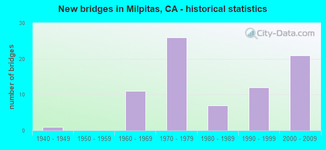
- New bridges - historical statistics
- 11940-1949
- 111960-1969
- 261970-1979
- 71980-1989
- 121990-1999
- 212000-2009

- Reconstructed bridges - Historical Statistics
- 11960-1969
- 11970-1979
- 31980-1989
- 21990-1999
- 02000-2009
- 22010-2019


- Bridge Condition - Deck
- 47.2%Good
- 16.7%Satisfactory
- 22.2%Fair
- 13.9%Poor

- Bridge Condition - Superstructure
- 66.7%Good
- 8.3%Satisfactory
- 22.2%Fair
- 2.8%Poor

- Bridge Condition - Substructure
- 83.3%Good
- 2.8%Satisfactory
- 13.9%Fair

- Bridge Condition - Channel
- 9.7%Excellent
- 35.5%Very good
- 35.5%Good
- 12.9%Satisfactory
- 3.2%Fair
- 3.2%Poor

- Bridge Condition - Culverts
- 35.7%Good
- 64.3%Satisfactory
Find on map >> Show street view
Structure Number: 37 0102L, Location: 04-SCL-101-29.83 (Lat: 37.278344, Lng: -121.806269), Route carried "on" structure: US 101, Year Built: 1947, Year Reconstructed: 1990, Status: Open, Structure Length: 12.28m (40.29ft), Average Daily Traffic: 64,000 (year 2009), Truck Traffic: 9%, Average Future Daily Traffic: 93,822 (year 2038), Design Load: HS 20, Features Intersected: COYOTE CREEK
Minimum Vertical Clearance: 30+ m (98+ ft), Kilometerpoint: 29.830, Lanes on structure: 4, Base Highway Network: Yes (Inventory Route: 1, Subroute: 1), Owner: State Highway Agency, Approaching Roadway Width: 21.0m (68.9ft), Skew: 3 degrees, Material/Design: Steel, Design/Construction: Stringer/Multi-beam, Number Of Spans In Main Unit: 4, Length of Maximum Span: 30.5m (100.1ft), Curb-To-Curb Width: 20.8m (68.2ft), Out-to-Out Width: 21.9m (71.9ft)
Condition: Deck: Poor, Superstructure: Good, Substructure: Good, Channel: Good, Operating Rating: 52.5 metric tons, Method Used To Determine Operating Rating: Load and Resistance Factor Rating (LRFR) rating reported by rating factor(RF) method using HL-93 loadings, Inventory Rating: 40.5 metric tons, Method Used To Determine Inventory Rating: Load and Resistance Factor Rating (LRFR) rating reported by rating factor(RF) method using HL-93 loadings, Structural Evaluation: Better than present minimum criteria, Deck Geometry: Equal to present minimum criteria, Waterway Adequacy: Better than present minimum criteria, Approach Roadway Alignment: Equal to present desirable criteria, Designated Inspection Frequency: Every 24 months, Critical Feature Inspection Frequency: Every 24 months, Inspection Date: January 2021, Critical Feature Inspection Date: June 2021, Deck Structure Type: Concrete Cast-file-Place
Find on map >> Show street view
Structure Number: 37 0109L, Location: 04-SCL-237-R9.30L-MPS (Lat: 37.425536, Lng: -121.916989), Route carried "on" structure: State highway 237, Year Built: 1972, Year Reconstructed: 1999, Status: Open, Structure Length: 9.63m (31.59ft), Average Daily Traffic: 62,500 (year 2009), Truck Traffic: 9%, Average Future Daily Traffic: 78,316 (year 2040), Design Load: HS 20, Features Intersected: INTERSTATE 880 & RAMPS
Minimum Vertical Clearance: 30+ m (98+ ft), Kilometerpoint: 9.300, Lanes on structure: 4, Lanes under structure: 9, Base Highway Network: Yes (Inventory Route: 2, Subroute: 1), Owner: State Highway Agency, Approaching Roadway Width: 16.7m (54.8ft), Material/Design: Prestressed concrete continuous, Design/Construction: Box Beam or Girders - Multiple, Number Of Spans In Main Unit: 2, Length of Maximum Span: 47.9m (157.2ft), Curb or Sidewalk Widths: Left: 1.5m (4.9ft), Right: 0.0m, Curb-To-Curb Width: 16.7m (54.8ft), Out-to-Out Width: 19.7m (64.6ft)
Condition: Deck: Fair, Superstructure: Good, Substructure: Good, Operating Rating: 54.1 metric tons, Method Used To Determine Operating Rating: Assigned rating based on Load Factor Design (LFD) reported in metric tons, Inventory Rating: 32.4 metric tons, Method Used To Determine Inventory Rating: Assigned rating based on Load Factor Design (LFD) reported in metric tons, Structural Evaluation: Better than present minimum criteria, Deck Geometry: Meets minimum limits, Underclear: Somewhat better than minimum adequacy, Approach Roadway Alignment: Equal to present desirable criteria, Designated Inspection Frequency: Every 24 months, Inspection Date: April 2020, Deck Structure Type: Concrete Cast-file-Place
Find on map >> Show street view
Structure Number: 37 0109R, Location: 04-SCL-237-R9.30R-MPS (Lat: 37.425389, Lng: -121.916836), Route carried "on" structure: State highway 237, Year Built: 1972, Status: Open, Structure Length: 9.63m (31.59ft), Average Daily Traffic: 62,500 (year 2009), Truck Traffic: 6%, Average Future Daily Traffic: 78,316 (year 2040), Design Load: HS 20+Mod, Features Intersected: INTERSTATE 880 & RAMPS
Minimum Vertical Clearance: 30+ m (98+ ft), Kilometerpoint: 9.300, Lanes on structure: 3, Lanes under structure: 9, Base Highway Network: Yes (Inventory Route: 2, Subroute: 1), Owner: State Highway Agency, Approaching Roadway Width: 13.5m (44.3ft), Material/Design: Prestressed concrete continuous, Design/Construction: Box Beam or Girders - Multiple, Number Of Spans In Main Unit: 2, Length of Maximum Span: 47.9m (157.2ft), Curb or Sidewalk Widths: Left: 0.0m, Right: 1.5m (4.9ft), Curb-To-Curb Width: 13.1m (43.0ft), Out-to-Out Width: 15.2m (49.9ft)
Condition: Deck: Fair, Superstructure: Good, Substructure: Good, Operating Rating: 38.6 metric tons, Method Used To Determine Operating Rating: Load and Resistance Factor Rating (LRFR) rating reported by rating factor(RF) method using HL-93 loadings, Inventory Rating: 24.3 metric tons, Method Used To Determine Inventory Rating: Load and Resistance Factor Rating (LRFR) rating reported by rating factor(RF) method using HL-93 loadings, Structural Evaluation: Equal to present minimum criteria, Deck Geometry: Meets minimum limits, Underclear: Equal to present minimum criteria, Approach Roadway Alignment: Equal to present desirable criteria, Designated Inspection Frequency: Every 24 months, Inspection Date: April 2020, Deck Structure Type: Concrete Cast-file-Place
Find on map >> Show street view
Structure Number: 37 0302, Location: 04-SCL-680-M7.63-MPS (Lat: 37.434564, Lng: -121.888017), Route carried "on" structure: Interstate 680, Year Built: 1971, Year Reconstructed: 2010, Status: Open, Structure Length: 5.73m (18.80ft), Average Daily Traffic: 137,000 (year 2010), Truck Traffic: 6%, Average Future Daily Traffic: 170,753 (year 2043), Design Load: HS 20+Mod, Features Intersected: SR 237 (CALAVERAS BLVD)
Minimum Vertical Clearance: 30+ m (98+ ft), Kilometerpoint: 7.630, Lanes on structure: 10, Lanes under structure: 8, Base Highway Network: Yes (Inventory Route: 6, Subroute: 1), Owner: State Highway Agency, Approaching Roadway Width: 71.2m (233.6ft), Skew: 30 degrees, Material/Design: Concrete continuous, Design/Construction: Box Beam or Girders - Multiple, Number Of Spans In Main Unit: 2, Length of Maximum Span: 28.3m (92.8ft), Curb-To-Curb Width: 71.2m (233.6ft), Out-to-Out Width: 73.5m (241.1ft)
Condition: Deck: Poor, Superstructure: Fair, Substructure: Good, Operating Rating: 54.1 metric tons, Method Used To Determine Operating Rating: Assigned rating based on Load Factor Design (LFD) reported in metric tons, Inventory Rating: 32.4 metric tons, Method Used To Determine Inventory Rating: Assigned rating based on Load Factor Design (LFD) reported in metric tons, Structural Evaluation: Somewhat better than minimum adequacy, Deck Geometry: Superior to present desirable criteria, Underclear: Meets minimum limits, Approach Roadway Alignment: Equal to present desirable criteria, Designated Inspection Frequency: Every 24 months, Inspection Date: July 2021, Deck Structure Type: Concrete Cast-file-Place
Find on map >> Show street view
Structure Number: 37 0303, Location: 04-SCL-680-M8.50-MPS (Lat: 37.446853, Lng: -121.890947), Route carried "on" structure: Interstate 680, Year Built: 1971, Year Reconstructed: 2010, Status: Open, Structure Length: 5.00m (16.40ft), Average Daily Traffic: 128,000 (year 2010), Truck Traffic: 6%, Average Future Daily Traffic: 155,344 (year 2041), Design Load: HS 20, Features Intersected: JACKLIN ROAD
Minimum Vertical Clearance: 30+ m (98+ ft), Kilometerpoint: 8.500, Lanes on structure: 7, Lanes under structure: 6, Base Highway Network: Yes (Inventory Route: 6, Subroute: 1), Owner: State Highway Agency, Approaching Roadway Width: 46.0m (150.9ft), Skew: 30 degrees, Material/Design: Concrete continuous, Design/Construction: Box Beam or Girders - Multiple, Number Of Spans In Main Unit: 2, Length of Maximum Span: 24.7m (81.0ft), Curb-To-Curb Width: 45.8m (150.3ft), Out-to-Out Width: 46.7m (153.2ft)
Condition: Deck: Poor, Superstructure: Fair, Substructure: Good, Operating Rating: 45.0 metric tons, Method Used To Determine Operating Rating: Load and Resistance Factor Rating (LRFR) rating reported by rating factor(RF) method using HL-93 loadings, Inventory Rating: 34.7 metric tons, Method Used To Determine Inventory Rating: Load and Resistance Factor Rating (LRFR) rating reported by rating factor(RF) method using HL-93 loadings, Structural Evaluation: Somewhat better than minimum adequacy, Deck Geometry: Superior to present desirable criteria, Underclear: Somewhat better than minimum adequacy, Approach Roadway Alignment: Equal to present desirable criteria, Designated Inspection Frequency: Every 24 months, Inspection Date: July 2021, Deck Structure Type: Concrete Cast-file-Place
Find on map >> Show street view
Structure Number: 37 0317, Location: 04-SCL-680-M8.38-MPS (Lat: 37.445264, Lng: -121.890622), Route carried "on" structure: Interstate 680, Year Built: 1971, Status: Open, Structure Length: 0.67m (2.20ft), Average Daily Traffic: 130,000 (year 2009), Truck Traffic: 5%, Average Future Daily Traffic: 236,352 (year 2039), Design Load: HS 20+Mod, Features Intersected: TULARCITOS CREEK
Minimum Vertical Clearance: 30+ m (98+ ft), Kilometerpoint: 8.380, Lanes on structure: 10, Base Highway Network: Yes (Inventory Route: 6, Subroute: 1), Owner: State Highway Agency, Approaching Roadway Width: 68.3m (224.1ft), Skew: 30 degrees, Material/Design: Concrete continuous, Design/Construction: Culvert, Number Of Spans In Main Unit: 2, Length of Maximum Span: 3.0m (9.8ft), Curb-To-Curb Width: 60.0m (196.9ft), Out-to-Out Width: 60.6m (198.8ft)
Condition: Channel: Good, Culverts: Good, Operating Rating: 54.1 metric tons, Method Used To Determine Operating Rating: Field evaluation and documented engineering judgment, Inventory Rating: 32.4 metric tons, Method Used To Determine Inventory Rating: Field evaluation and documented engineering judgment, Structural Evaluation: Better than present minimum criteria, Deck Geometry: Superior to present desirable criteria, Waterway Adequacy: Equal to present desirable criteria, Approach Roadway Alignment: Equal to present desirable criteria, Designated Inspection Frequency: Every 48 months, Inspection Date: July 2021
Find on map >> Show street view
Structure Number: 37 0352H, Location: 04-SCL-101-34.87-SJS (Lat: 37.338058, Lng: -121.849100), Route carried "on" structure: Ramp US 101, Year Built: 1974, Year Reconstructed: 1982, Status: Open, Structure Length: 263.53m (864.60ft), Average Daily Traffic: 40,000 (year 1998), Truck Traffic: 6%, Average Future Daily Traffic: 54,518 (year 2041), Design Load: HS 20+Mod, Features Intersected: I 280,I 680,US 101,STORY
Minimum Vertical Clearance: 5.36m (17.59ft), Kilometerpoint: 34.870, Lanes on structure: 2, Lanes under structure: 23, Base Highway Network: Yes, Owner: State Highway Agency, Approaching Roadway Width: 13.7m (44.9ft), Skew: 9 degrees, Material/Design: Concrete continuous, Design/Construction: Box Beam or Girders - Multiple, Number Of Spans In Main Unit: 55, Number Of Approach Spans: 7, Length of Maximum Span: 47.9m (157.2ft), Curb-To-Curb Width: 12.3m (40.4ft), Out-to-Out Width: 13.3m (43.6ft)
Condition: Deck: Fair, Superstructure: Fair, Substructure: Good, Operating Rating: 84.2 metric tons, Method Used To Determine Operating Rating: Load Factor (LF), Inventory Rating: 32.4 metric tons, Method Used To Determine Inventory Rating: Load Factor (LF), Structural Evaluation: Somewhat better than minimum adequacy, Deck Geometry: Superior to present desirable criteria, Underclear: High priority of corrective action, Approach Roadway Alignment: Better than present minimum criteria, Designated Inspection Frequency: Every 24 months, Inspection Date: January 2021, Deck Structure Type: Concrete Cast-file-Place
Find on map >> Show street view
Structure Number: 37 0355L, Location: 04-SCL-237-10.00-MPS (Lat: 37.431253, Lng: -121.907472), Route carried "on" structure: State highway 237, Year Built: 1969, Status: Open, Structure Length: 17.21m (56.46ft), Average Daily Traffic: 36,500 (year 2009), Truck Traffic: 5%, Average Future Daily Traffic: 93,871 (year 2042), Design Load: HS 20, Features Intersected: UPRR,BNSF,AMTRAK,STREETS
Minimum Vertical Clearance: 30+ m (98+ ft), Kilometerpoint: 10.000, Lanes on structure: 2, Lanes under structure: 8, Base Highway Network: Yes (Inventory Route: 2, Subroute: 1), Owner: State Highway Agency, Approaching Roadway Width: 10.0m (32.8ft), Skew: 9 degrees, Material/Design: Concrete continuous, Design/Construction: Box Beam or Girders - Multiple, Number Of Spans In Main Unit: 7, Length of Maximum Span: 28.0m (91.9ft), Curb or Sidewalk Widths: Left: 1.5m (4.9ft), Right: 0.0m, Curb-To-Curb Width: 9.1m (29.9ft), Out-to-Out Width: 11.6m (38.1ft)
Condition: Deck: Good, Superstructure: Fair, Substructure: Fair, Operating Rating: 63.8 metric tons, Method Used To Determine Operating Rating: Load Factor (LF), Inventory Rating: 38.6 metric tons, Method Used To Determine Inventory Rating: Load Factor (LF), Structural Evaluation: Somewhat better than minimum adequacy, Deck Geometry: Meets minimum limits, Underclear: High priority of corrective action, Approach Roadway Alignment: Better than present minimum criteria, Designated Inspection Frequency: Every 24 months, Inspection Date: April 2020, Deck Structure Type: Concrete Cast-file-Place, Wearing Surface/Protective System: Wearing Surface: Integral Concrete
Find on map >> Show street view
Structure Number: 37 0355R, Location: 04-SCL-237-10.00-MPS (Lat: 37.431083, Lng: -121.907383), Route carried "on" structure: State highway 237, Year Built: 1969, Status: Open, Structure Length: 17.37m (56.99ft), Average Daily Traffic: 36,500 (year 2009), Truck Traffic: 5%, Average Future Daily Traffic: 93,871 (year 2042), Design Load: HS 20+Mod, Features Intersected: UPRR,BNSF,AMTRAK,STREETS
Minimum Vertical Clearance: 30+ m (98+ ft), Kilometerpoint: 10.000, Lanes on structure: 2, Lanes under structure: 8, Base Highway Network: Yes (Inventory Route: 2, Subroute: 1), Owner: State Highway Agency, Approaching Roadway Width: 10.2m (33.5ft), Skew: 9 degrees, Material/Design: Concrete continuous, Design/Construction: Box Beam or Girders - Multiple, Number Of Spans In Main Unit: 7, Length of Maximum Span: 28.0m (91.9ft), Curb-To-Curb Width: 9.8m (32.2ft), Out-to-Out Width: 10.7m (35.1ft)
Condition: Deck: Good, Superstructure: Fair, Substructure: Good, Operating Rating: 74.5 metric tons, Method Used To Determine Operating Rating: Load Factor (LF), Inventory Rating: 44.7 metric tons, Method Used To Determine Inventory Rating: Load Factor (LF), Structural Evaluation: Somewhat better than minimum adequacy, Deck Geometry: Meets minimum limits, Underclear: High priority of corrective action, Approach Roadway Alignment: Better than present minimum criteria, Designated Inspection Frequency: Every 24 months, Inspection Date: April 2020, Deck Structure Type: Concrete Cast-file-Place, Wearing Surface/Protective System: Wearing Surface: Integral Concrete
Find on map >> Show street view
Structure Number: 37 0373, Location: 04-SCL-680-M6.17-MPS (Lat: 37.414081, Lng: -121.880831), Route carried "on" structure: City street C007, Year Built: 1974, Status: Open, Structure Length: 9.66m (31.69ft), Average Daily Traffic: 22,241 (year 2009), Truck Traffic: 1%, Average Future Daily Traffic: 21,808 (year 2041), Design Load: HS 20, Features Intersected: INTERSTATE 680, Facility Carried by Structure: LANDESS AVE EB
Minimum Vertical Clearance: 30+ m (98+ ft), Kilometerpoint: 0.000, Lanes on structure: 3, Lanes under structure: 10, Base Highway Network: Yes, Owner: State Highway Agency, Approaching Roadway Width: 14.0m (45.9ft), Material/Design: Prestressed concrete continuous, Design/Construction: Box Beam or Girders - Multiple, Number Of Spans In Main Unit: 2, Length of Maximum Span: 47.5m (155.8ft), Curb or Sidewalk Widths: Left: 0.0m, Right: 2.4m (7.9ft), Curb-To-Curb Width: 14.0m (45.9ft), Out-to-Out Width: 17.1m (56.1ft)
Condition: Deck: Poor, Superstructure: Good, Substructure: Good, Operating Rating: 63.8 metric tons, Method Used To Determine Operating Rating: Load and Resistance Factor Rating (LRFR) rating reported by rating factor(RF) method using HL-93 loadings, Inventory Rating: 40.2 metric tons, Method Used To Determine Inventory Rating: Load and Resistance Factor Rating (LRFR) rating reported by rating factor(RF) method using HL-93 loadings, Structural Evaluation: Better than present minimum criteria, Deck Geometry: Somewhat better than minimum adequacy, Underclear: Equal to present minimum criteria, Approach Roadway Alignment: Equal to present desirable criteria, Designated Inspection Frequency: Every 24 months, Inspection Date: July 2021, Deck Structure Type: Concrete Cast-file-Place
Find on map >> Show street view
Structure Number: 37 0374, Location: 04-SCL-680-M6.18-MPS (Lat: 37.414300, Lng: -121.880897), Route carried "on" structure: City street C007, Year Built: 1974, Status: Open, Structure Length: 9.66m (31.69ft), Average Daily Traffic: 17,880 (year 2009), Truck Traffic: 1%, Average Future Daily Traffic: 21,808 (year 2041), Design Load: HS 20, Features Intersected: INTERSTATE 680, Facility Carried by Structure: LANDESS AVE WB
Minimum Vertical Clearance: 30+ m (98+ ft), Kilometerpoint: 0.000, Lanes on structure: 3, Lanes under structure: 10, Base Highway Network: Yes, Owner: State Highway Agency, Approaching Roadway Width: 9.4m (30.8ft), Material/Design: Prestressed concrete continuous, Design/Construction: Box Beam or Girders - Multiple, Number Of Spans In Main Unit: 2, Length of Maximum Span: 47.5m (155.8ft), Curb or Sidewalk Widths: Left: 2.4m (7.9ft), Right: 0.0m, Curb-To-Curb Width: 13.1m (43.0ft), Out-to-Out Width: 16.2m (53.1ft)
Condition: Deck: Fair, Superstructure: Good, Substructure: Good, Operating Rating: 65.4 metric tons, Method Used To Determine Operating Rating: Load and Resistance Factor Rating (LRFR) rating reported by rating factor(RF) method using HL-93 loadings, Inventory Rating: 38.9 metric tons, Method Used To Determine Inventory Rating: Load and Resistance Factor Rating (LRFR) rating reported by rating factor(RF) method using HL-93 loadings, Structural Evaluation: Better than present minimum criteria, Deck Geometry: Meets minimum limits, Underclear: Equal to present minimum criteria, Approach Roadway Alignment: Equal to present desirable criteria, Designated Inspection Frequency: Every 24 months, Inspection Date: July 2021, Deck Structure Type: Concrete Cast-file-Place
Find on map >> Show street view
Structure Number: 37 0377, Location: 04-SCL-680-M7.46-MPS (Lat: 37.432914, Lng: -121.887258), Route carried "on" structure: Interstate 680, Year Built: 1971, Status: Open, Structure Length: 0.67m (2.20ft), Average Daily Traffic: 130,000 (year 2009), Truck Traffic: 5%, Average Future Daily Traffic: 236,352 (year 2039), Features Intersected: ARROYO DE LOS COCHES
Minimum Vertical Clearance: 30+ m (98+ ft), Kilometerpoint: 7.460, Lanes on structure: 11, Base Highway Network: Yes (Inventory Route: 6, Subroute: 1), Owner: State Highway Agency, Approaching Roadway Width: 59.2m (194.2ft), Skew: 30 degrees, Material/Design: Concrete continuous, Design/Construction: Culvert, Number Of Spans In Main Unit: 2, Length of Maximum Span: 3.1m (10.2ft)
Condition: Channel: Excellent, Culverts: Satisfactory, Operating Rating: 54.1 metric tons, Method Used To Determine Operating Rating: Field evaluation and documented engineering judgment, Inventory Rating: 32.4 metric tons, Method Used To Determine Inventory Rating: Field evaluation and documented engineering judgment, Structural Evaluation: Equal to present minimum criteria, Waterway Adequacy: Equal to present desirable criteria, Approach Roadway Alignment: Equal to present desirable criteria, Designated Inspection Frequency: Every 24 months, Inspection Date: July 2021
Find on map >> Show street view
Structure Number: 37 0379, Location: 04-SCL-237-T9.85-MPS (Lat: 37.429864, Lng: -121.909175), Route carried "on" structure: State highway 237, Year Built: 1962, Year Reconstructed: 1969, Status: Open, Structure Length: 0.91m (2.99ft), Average Daily Traffic: 73,000 (year 2009), Truck Traffic: 5%, Average Future Daily Traffic: 187,741 (year 2042), Features Intersected: PENITENCIA CREEK
Minimum Vertical Clearance: 30+ m (98+ ft), Kilometerpoint: 9.850, Lanes on structure: 7, Base Highway Network: Yes (Inventory Route: 2, Subroute: 1), Owner: State Highway Agency, Approaching Roadway Width: 26.2m (86.0ft), Skew: 33 degrees, Material/Design: Concrete continuous, Design/Construction: Culvert, Number Of Spans In Main Unit: 2, Length of Maximum Span: 3.7m (12.1ft), Curb or Sidewalk Widths: Left: 3.1m (10.2ft), Right: 4.0m (13.1ft), Curb-To-Curb Width: 26.2m (86.0ft), Out-to-Out Width: 36.5m (119.8ft)
Condition: Channel: Satisfactory, Culverts: Good, Operating Rating: 40.5 metric tons, Method Used To Determine Operating Rating: Field evaluation and documented engineering judgment, Inventory Rating: 24.3 metric tons, Method Used To Determine Inventory Rating: Field evaluation and documented engineering judgment, Structural Evaluation: Equal to present minimum criteria, Deck Geometry: Meets minimum limits, Waterway Adequacy: Equal to present desirable criteria, Approach Roadway Alignment: Equal to present desirable criteria, Designated Inspection Frequency: Every 24 months, Inspection Date: April 2020, Deck Structure Type: Concrete Cast-file-Place, Wearing Surface/Protective System: Wearing Surface: Bituminous
Find on map >> Show street view
Structure Number: 37 0380R, Location: 04-SCL-237-10.20-MPS (Lat: 37.431706, Lng: -121.903981), Route carried "on" structure: State highway 237, Year Built: 1969, Status: Open, Structure Length: 11.85m (38.88ft), Average Daily Traffic: 36,500 (year 2009), Truck Traffic: 5%, Average Future Daily Traffic: 93,871 (year 2042), Design Load: HS 20+Mod, Features Intersected: UP RR YD,ACCESS RD,BARTD
Minimum Vertical Clearance: 30+ m (98+ ft), Kilometerpoint: 10.200, Lanes on structure: 2, Lanes under structure: 1, Base Highway Network: Yes (Inventory Route: 2, Subroute: 1), Owner: State Highway Agency, Approaching Roadway Width: 10.4m (34.1ft), Skew: 1 degrees, Material/Design: Concrete continuous, Design/Construction: Box Beam or Girders - Multiple, Number Of Spans In Main Unit: 5, Length of Maximum Span: 25.0m (82.0ft), Curb-To-Curb Width: 9.8m (32.2ft), Out-to-Out Width: 10.7m (35.1ft)
Condition: Deck: Good, Superstructure: Satisfactory, Substructure: Good, Operating Rating: 31.1 metric tons, Method Used To Determine Operating Rating: Load and Resistance Factor Rating (LRFR) rating reported by rating factor(RF) method using HL-93 loadings, Inventory Rating: 21.7 metric tons, Method Used To Determine Inventory Rating: Load and Resistance Factor Rating (LRFR) rating reported by rating factor(RF) method using HL-93 loadings, Structural Evaluation: Somewhat better than minimum adequacy, Deck Geometry: Meets minimum limits, Underclear: High priority of corrective action, Approach Roadway Alignment: Equal to present minimum criteria, Designated Inspection Frequency: Every 24 months, Inspection Date: April 2020, Deck Structure Type: Concrete Cast-file-Place, Wearing Surface/Protective System: Wearing Surface: Integral Concrete
Find on map >> Show street view
Structure Number: 37 0381, Location: 04-SCL-237-10.84-MPS (Lat: 37.433578, Lng: -121.892772), Route carried "on" structure: State highway 237, Year Built: 1970, Status: Open, Structure Length: 1.43m (4.69ft), Average Daily Traffic: 73,000 (year 2009), Truck Traffic: 5%, Average Future Daily Traffic: 187,741 (year 2042), Features Intersected: BERRYESSA CREEK
Minimum Vertical Clearance: 30+ m (98+ ft), Kilometerpoint: 10.840, Lanes on structure: 8, Base Highway Network: Yes (Inventory Route: 2, Subroute: 1), Owner: State Highway Agency, Approaching Roadway Width: 30.5m (100.1ft), Skew: 30 degrees, Material/Design: Concrete continuous, Design/Construction: Culvert, Number Of Spans In Main Unit: 4, Length of Maximum Span: 3.4m (11.2ft), Curb or Sidewalk Widths: Left: 3.6m (11.8ft), Right: 3.4m (11.2ft), Curb-To-Curb Width: 30.5m (100.1ft), Out-to-Out Width: 39.1m (128.3ft)
Condition: Channel: Very good, Culverts: Good, Operating Rating: 40.5 metric tons, Method Used To Determine Operating Rating: Field evaluation and documented engineering judgment, Inventory Rating: 24.3 metric tons, Method Used To Determine Inventory Rating: Field evaluation and documented engineering judgment, Structural Evaluation: Equal to present minimum criteria, Deck Geometry: Somewhat better than minimum adequacy, Waterway Adequacy: Somewhat better than minimum adequacy, Approach Roadway Alignment: Equal to present desirable criteria, Designated Inspection Frequency: Every 24 months, Inspection Date: April 2020, Deck Structure Type: Concrete Cast-file-Place, Wearing Surface/Protective System: Wearing Surface: Bituminous
Find on map >> Show street view
Structure Number: 37 0426L, Location: 04-SCL-880-7.70-MPS (Lat: 37.415511, Lng: -121.913361), Route carried "on" structure: City street , Year Built: 1995, Status: Open, Structure Length: 8.23m (27.00ft), Average Daily Traffic: 6,130 (year 2019), Truck Traffic: 2%, Average Future Daily Traffic: 8,522 (year 2043), Design Load: HS 20+Mod, Features Intersected: INTERSTATE 880, Facility Carried by Structure: TASMAN DRIVE WB
Minimum Vertical Clearance: 30+ m (98+ ft), Kilometerpoint: 0.000, Lanes on structure: 4, Lanes under structure: 10, Owner: State Highway Agency, Approaching Roadway Width: 17.4m (57.1ft), Material/Design: Prestressed concrete continuous, Design/Construction: Box Beam or Girders - Multiple, Number Of Spans In Main Unit: 3, Length of Maximum Span: 30.5m (100.1ft), Curb or Sidewalk Widths: Left: 1.8m (5.9ft), Right: 0.0m, Curb-To-Curb Width: 17.4m (57.1ft), Out-to-Out Width: 20.0m (65.6ft)
Condition: Deck: Satisfactory, Superstructure: Good, Substructure: Good, Operating Rating: 54.1 metric tons, Method Used To Determine Operating Rating: Assigned rating based on Load Factor Design (LFD) reported in metric tons, Inventory Rating: 32.4 metric tons, Method Used To Determine Inventory Rating: Assigned rating based on Load Factor Design (LFD) reported in metric tons, Structural Evaluation: Better than present minimum criteria, Deck Geometry: Somewhat better than minimum adequacy, Underclear: Equal to present minimum criteria, Approach Roadway Alignment: Equal to present desirable criteria, Designated Inspection Frequency: Every 24 months, Inspection Date: March 2021, Deck Structure Type: Concrete Cast-file-Place
Find on map >> Show street view
Structure Number: 37 0426R, Location: 04-SCL-880-7.68-MPS (Lat: 37.415214, Lng: -121.913261), Route carried "on" structure: City street , Year Built: 1995, Status: Open, Structure Length: 8.23m (27.00ft), Average Daily Traffic: 5,550 (year 2019), Truck Traffic: 2%, Average Future Daily Traffic: 6,391 (year 2041), Design Load: HS 20+Mod, Features Intersected: INTERSTATE 880, Facility Carried by Structure: TASMAN DRIVE EB
Minimum Vertical Clearance: 30+ m (98+ ft), Kilometerpoint: 0.000, Lanes on structure: 3, Lanes under structure: 10, Owner: State Highway Agency, Approaching Roadway Width: 17.4m (57.1ft), Material/Design: Prestressed concrete continuous, Design/Construction: Box Beam or Girders - Multiple, Number Of Spans In Main Unit: 3, Length of Maximum Span: 30.5m (100.1ft), Curb or Sidewalk Widths: Left: 0.0m, Right: 1.8m (5.9ft), Curb-To-Curb Width: 17.4m (57.1ft), Out-to-Out Width: 20.0m (65.6ft)
Condition: Deck: Satisfactory, Superstructure: Good, Substructure: Good, Operating Rating: 54.1 metric tons, Method Used To Determine Operating Rating: Assigned rating based on Load Factor Design (LFD) reported in metric tons, Inventory Rating: 32.4 metric tons, Method Used To Determine Inventory Rating: Assigned rating based on Load Factor Design (LFD) reported in metric tons, Structural Evaluation: Better than present minimum criteria, Deck Geometry: Superior to present desirable criteria, Underclear: Equal to present minimum criteria, Approach Roadway Alignment: Superior to present desirable criteria, Designated Inspection Frequency: Every 24 months, Inspection Date: March 2021, Deck Structure Type: Concrete Cast-file-Place
Find on map >> Show street view
Structure Number: 37 0474, Location: 04-SCL-237-R8.92R-MPS (Lat: 37.423914, Lng: -121.923606), Route carried "on" structure: City street , Year Built: 1991, Status: Open, Structure Length: 10.71m (35.14ft), Average Daily Traffic: 15,261 (year 2003), Truck Traffic: 5%, Average Future Daily Traffic: 22,689 (year 2042), Design Load: HS 20+Mod, Features Intersected: STATE ROUTE 237 & CONN, Facility Carried by Structure: MCCARTHY BOULEVARD
Minimum Vertical Clearance: 30+ m (98+ ft), Kilometerpoint: 0.000, Lanes on structure: 8, Lanes under structure: 8, Owner: State Highway Agency, Approaching Roadway Width: 24.0m (78.7ft), Skew: 30 degrees, Material/Design: Prestressed concrete continuous, Design/Construction: Box Beam or Girders - Multiple, Number Of Spans In Main Unit: 2, Length of Maximum Span: 61.9m (203.1ft), Curb or Sidewalk Widths: Left: 1.8m (5.9ft), Right: 3.9m (12.8ft), Curb-To-Curb Width: 23.8m (78.1ft), Out-to-Out Width: 38.7m (127.0ft)
Condition: Deck: Satisfactory, Superstructure: Good, Substructure: Good, Operating Rating: 54.1 metric tons, Method Used To Determine Operating Rating: Assigned rating based on Load Factor Design (LFD) reported in metric tons, Inventory Rating: 32.4 metric tons, Method Used To Determine Inventory Rating: Assigned rating based on Load Factor Design (LFD) reported in metric tons, Structural Evaluation: Better than present minimum criteria, Deck Geometry: High priority of replacement, Underclear: High priority of corrective action, Approach Roadway Alignment: Equal to present desirable criteria, Designated Inspection Frequency: Every 24 months, Inspection Date: April 2020, Deck Structure Type: Concrete Cast-file-Place
Find on map >> Show street view
Structure Number: 37 0565, Location: 04-SCL-017-4.30 (Lat: 37.190428, Lng: -121.993381), Route carried "on" structure: County highway , Year Built: 1996, Status: Open, Structure Length: 6.27m (20.57ft), Average Daily Traffic: 1,100 (year 2017), Truck Traffic: 1%, Average Future Daily Traffic: 1,664 (year 2038), Design Load: HS 20+Mod, Features Intersected: STATE ROUTE 17, Facility Carried by Structure: BEAR CREEK ROAD
Minimum Vertical Clearance: 30+ m (98+ ft), Kilometerpoint: 0.000, Lanes on structure: 3, Lanes under structure: 6, Owner: State Highway Agency, Approaching Roadway Width: 12.2m (40.0ft), Material/Design: Prestressed concrete continuous, Design/Construction: Box Beam or Girders - Multiple, Number Of Spans In Main Unit: 2, Length of Maximum Span: 34.9m (114.5ft), Curb or Sidewalk Widths: Left: 2.4m (7.9ft), Right: 0.0m, Curb-To-Curb Width: 13.4m (44.0ft), Out-to-Out Width: 16.7m (54.8ft)
Condition: Deck: Good, Superstructure: Good, Substructure: Good, Operating Rating: 54.1 metric tons, Method Used To Determine Operating Rating: Assigned rating based on Load Factor Design (LFD) reported in metric tons, Inventory Rating: 32.4 metric tons, Method Used To Determine Inventory Rating: Assigned rating based on Load Factor Design (LFD) reported in metric tons, Structural Evaluation: Better than present minimum criteria, Deck Geometry: Somewhat better than minimum adequacy, Underclear: Equal to present minimum criteria, Approach Roadway Alignment: Equal to present minimum criteria, Designated Inspection Frequency: Every 24 months, Inspection Date: July 2020, Deck Structure Type: Concrete Cast-file-Place
Find on map >> Show street view
Structure Number: 37 0568G, Location: 04-SCL-237-R9.12R-MPS (Lat: 37.424314, Lng: -121.919667), Route carried "on" structure: Ramp State highway 237, Year Built: 2002, Status: Open, Structure Length: 58.67m (192.49ft), Average Daily Traffic: 25,000 (year 2006), Truck Traffic: 9%, Average Future Daily Traffic: 43,039 (year 2042), Design Load: HS 20+Mod, Features Intersected: WB 237, I 880 & RAMPS
Minimum Vertical Clearance: 30+ m (98+ ft), Kilometerpoint: 9.120, Lanes on structure: 2, Lanes under structure: 13, Owner: State Highway Agency, Approaching Roadway Width: 15.3m (50.2ft), Material/Design: Prestressed concrete continuous, Design/Construction: Box Beam or Girders - Multiple, Number Of Spans In Main Unit: 10, Length of Maximum Span: 72.0m (236.2ft), Curb-To-Curb Width: 15.3m (50.2ft), Out-to-Out Width: 16.4m (53.8ft)
Condition: Deck: Good, Superstructure: Fair, Substructure: Fair, Operating Rating: 54.1 metric tons, Method Used To Determine Operating Rating: Assigned rating based on Load Factor Design (LFD) reported in metric tons, Inventory Rating: 32.4 metric tons, Method Used To Determine Inventory Rating: Assigned rating based on Load Factor Design (LFD) reported in metric tons, Structural Evaluation: Somewhat better than minimum adequacy, Deck Geometry: Superior to present desirable criteria, Underclear: Meets minimum limits, Approach Roadway Alignment: Equal to present desirable criteria, Designated Inspection Frequency: Every 24 months, Inspection Date: April 2020, Deck Structure Type: Concrete Cast-file-Place
Find on map >> Show street view
Structure Number: 37 0571G, Location: 04-SCL-237-R9.13R-MPS (Lat: 37.424200, Lng: -121.919619), Route carried "on" structure: Ramp State highway 237, Year Built: 2002, Status: Open, Structure Length: 11.71m (38.42ft), Average Daily Traffic: 7,001 (year 2004), Truck Traffic: 5%, Average Future Daily Traffic: 10,408 (year 2042), Design Load: HS 20+Mod, Features Intersected: EB STATE ROUTE 237
Minimum Vertical Clearance: 30+ m (98+ ft), Kilometerpoint: 9.130, Lanes on structure: 1, Lanes under structure: 3, Owner: State Highway Agency, Approaching Roadway Width: 8.1m (26.6ft), Material/Design: Prestressed concrete continuous, Design/Construction: Box Beam or Girders - Multiple, Number Of Spans In Main Unit: 3, Length of Maximum Span: 44.9m (147.3ft), Curb-To-Curb Width: 8.1m (26.6ft), Out-to-Out Width: 9.2m (30.2ft)
Condition: Deck: Good, Superstructure: Good, Substructure: Fair, Operating Rating: 54.1 metric tons, Method Used To Determine Operating Rating: Assigned rating based on Load Factor Design (LFD) reported in metric tons, Inventory Rating: 32.4 metric tons, Method Used To Determine Inventory Rating: Assigned rating based on Load Factor Design (LFD) reported in metric tons, Structural Evaluation: Somewhat better than minimum adequacy, Deck Geometry: Superior to present desirable criteria, Underclear: Equal to present minimum criteria, Approach Roadway Alignment: Equal to present desirable criteria, Designated Inspection Frequency: Every 24 months, Inspection Date: April 2020, Deck Structure Type: Concrete Cast-file-Place
Find on map >> Show street view
Structure Number: 37 0582, Location: 04-SCL-880-10.38-MPS (Lat: 37.453594, Lng: -121.922411), Route carried "on" structure: Interstate 880, Year Built: 2002, Status: Open, Structure Length: 3.64m (11.94ft), Average Daily Traffic: 194,000 (year 2019), Truck Traffic: 12%, Average Future Daily Traffic: 247,901 (year 2042), Design Load: HS 20+Mod, Features Intersected: PENITENCIA CREEK
Minimum Vertical Clearance: 30+ m (98+ ft), Kilometerpoint: 10.380, Lanes on structure: 13, Base Highway Network: Yes (Inventory Route: 8, Subroute: 1), Owner: State Highway Agency, Approaching Roadway Width: 68.2m (223.8ft), Skew: 30 degrees, Material/Design: Concrete continuous, Design/Construction: Slab, Number Of Spans In Main Unit: 4, Length of Maximum Span: 9.1m (29.9ft), Curb-To-Curb Width: 68.2m (223.8ft), Out-to-Out Width: 69.9m (229.3ft)
Condition: Deck: Good, Superstructure: Good, Substructure: Good, Channel: Very good, Operating Rating: 54.1 metric tons, Method Used To Determine Operating Rating: Assigned rating based on Load Factor Design (LFD) reported in metric tons, Inventory Rating: 32.4 metric tons, Method Used To Determine Inventory Rating: Assigned rating based on Load Factor Design (LFD) reported in metric tons, Structural Evaluation: Better than present minimum criteria, Deck Geometry: Superior to present desirable criteria, Waterway Adequacy: Equal to present desirable criteria, Approach Roadway Alignment: Equal to present desirable criteria, Designated Inspection Frequency: Every 48 months, Inspection Date: March 2021, Deck Structure Type: Concrete Cast-file-Place
Find on map >> Show street view
Structure Number: 37 0582K, Location: 04-SCL-880-10.38-MPS (Lat: 37.453417, Lng: -121.923300), Route carried "on" structure: Ramp Interstate 880, Year Built: 2002, Status: Open, Structure Length: 9.10m (29.86ft), Average Daily Traffic: 1,500 (year 2019), Truck Traffic: 5%, Average Future Daily Traffic: 2,500 (year 2041), Design Load: HS 20+Mod, Features Intersected: PENITENCIA CREEK
Minimum Vertical Clearance: 30+ m (98+ ft), Kilometerpoint: 10.380, Lanes on structure: 2, Base Highway Network: Yes, Owner: State Highway Agency, Approaching Roadway Width: 10.8m (35.4ft), Material/Design: Prestressed concrete continuous, Design/Construction: Box Beam or Girders - Multiple, Number Of Spans In Main Unit: 3, Length of Maximum Span: 34.0m (111.5ft), Curb-To-Curb Width: 10.8m (35.4ft), Out-to-Out Width: 11.8m (38.7ft)
Condition: Deck: Good, Superstructure: Good, Substructure: Fair, Channel: Very good, Operating Rating: 54.1 metric tons, Method Used To Determine Operating Rating: Assigned rating based on Load Factor Design (LFD) reported in metric tons, Inventory Rating: 32.4 metric tons, Method Used To Determine Inventory Rating: Assigned rating based on Load Factor Design (LFD) reported in metric tons, Structural Evaluation: Somewhat better than minimum adequacy, Deck Geometry: Better than present minimum criteria, Waterway Adequacy: Equal to present desirable criteria, Approach Roadway Alignment: Equal to present desirable criteria, Designated Inspection Frequency: Every 24 months, Inspection Date: March 2021, Deck Structure Type: Concrete Cast-file-Place
Find on map >> Show street view
Structure Number: 37 0627H, Location: 04-SCL-237-9.50-MPS (Lat: 37.421850, Lng: -121.915764), Route carried "on" structure: Ramp State highway 237, Year Built: 2004, Status: Open, Structure Length: 18.76m (61.55ft), Average Daily Traffic: 15,400 (year 2004), Truck Traffic: 5%, Average Future Daily Traffic: 20,814 (year 2042), Design Load: HS 20+Mod, Features Intersected: S880-TASMAN DR OFF RAMP
Minimum Vertical Clearance: 30+ m (98+ ft), Kilometerpoint: 9.500, Lanes on structure: 2, Lanes under structure: 2, Owner: State Highway Agency, Approaching Roadway Width: 12.0m (39.4ft), Material/Design: Prestressed concrete continuous, Design/Construction: Box Beam or Girders - Multiple, Number Of Spans In Main Unit: 4, Length of Maximum Span: 56.4m (185.0ft), Curb-To-Curb Width: 11.7m (38.4ft), Out-to-Out Width: 12.8m (42.0ft)
Condition: Deck: Fair, Superstructure: Fair, Substructure: Good, Operating Rating: 54.1 metric tons, Method Used To Determine Operating Rating: Assigned rating based on Load Factor Design (LFD) reported in metric tons, Inventory Rating: 32.4 metric tons, Method Used To Determine Inventory Rating: Assigned rating based on Load Factor Design (LFD) reported in metric tons, Structural Evaluation: Somewhat better than minimum adequacy, Deck Geometry: Superior to present desirable criteria, Underclear: Superior to present desirable criteria, Approach Roadway Alignment: Equal to present desirable criteria, Designated Inspection Frequency: Every 24 months, Inspection Date: April 2020, Deck Structure Type: Concrete Cast-file-Place
Find on map >> Show street view
Structure Number: 37 0640M, Location: 04-SCL-880-7.98-MPS (Lat: 37.419156, Lng: -121.914514), Route carried "on" structure: Interstate 880, Year Built: 2002, Status: Open, Structure Length: 1.66m (5.45ft), Average Daily Traffic: 150,000 (year 2019), Truck Traffic: 8%, Average Future Daily Traffic: 198,933 (year 2041), Design Load: HS 20+Mod, Features Intersected: HETCH HETCHY AQUEDUCT
Minimum Vertical Clearance: 30+ m (98+ ft), Kilometerpoint: 7.980, Lanes on structure: 3, Base Highway Network: Yes (Inventory Route: 8, Subroute: 1), Owner: State Highway Agency, Approaching Roadway Width: 35.0m (114.8ft), Material/Design: Concrete continuous, Design/Construction: Slab, Number Of Spans In Main Unit: 3, Length of Maximum Span: 5.4m (17.7ft), Curb-To-Curb Width: 33.2m (108.9ft), Out-to-Out Width: 35.0m (114.8ft)
Condition: Deck: Good, Superstructure: Good, Substructure: Good, Operating Rating: 54.1 metric tons, Method Used To Determine Operating Rating: Assigned rating based on Load Factor Design (LFD) reported in metric tons, Inventory Rating: 32.4 metric tons, Method Used To Determine Inventory Rating: Assigned rating based on Load Factor Design (LFD) reported in metric tons, Structural Evaluation: Better than present minimum criteria, Deck Geometry: Superior to present desirable criteria, Approach Roadway Alignment: Equal to present desirable criteria, Designated Inspection Frequency: Every 24 months, Inspection Date: March 2021, Deck Structure Type: Concrete Cast-file-Place, Wearing Surface/Protective System: Wearing Surface: Bituminous
Find on map >> Show street view
Structure Number: 37 0669M, Location: 04-SCL-880-8.00-MPS (Lat: 37.419303, Lng: -121.914022), Route carried "on" structure: Interstate 880, Year Built: 2003, Status: Open, Structure Length: 1.66m (5.45ft), Average Daily Traffic: 11,500 (year 2019), Truck Traffic: 8%, Average Future Daily Traffic: 15,000 (year 2042), Design Load: HL 93, Features Intersected: HETCH HETCHY AQUEDUCT
Minimum Vertical Clearance: 30+ m (98+ ft), Kilometerpoint: 8.000, Lanes on structure: 1, Base Highway Network: Yes (Inventory Route: 8, Subroute: 1), Owner: State Highway Agency, Approaching Roadway Width: 6.7m (22.0ft), Material/Design: Concrete continuous, Design/Construction: Slab, Number Of Spans In Main Unit: 3, Length of Maximum Span: 5.9m (19.4ft), Curb-To-Curb Width: 6.7m (22.0ft), Out-to-Out Width: 7.1m (23.3ft)
Condition: Deck: Good, Superstructure: Good, Substructure: Good, Operating Rating: 42.1 metric tons, Method Used To Determine Operating Rating: Assigned ratings based on Load and Resistance Factor Design (LRFD) reported by rating factor (RF) using HL93 loadings, Inventory Rating: 32.4 metric tons, Method Used To Determine Inventory Rating: Assigned ratings based on Load and Resistance Factor Design (LRFD) reported by rating factor (RF) using HL93 loadings, Structural Evaluation: Better than present minimum criteria, Deck Geometry: High priority of replacement, Approach Roadway Alignment: Equal to present desirable criteria, Designated Inspection Frequency: Every 48 months, Inspection Date: March 2021, Deck Structure Type: Concrete Cast-file-Place
Find on map >> Show street view
Structure Number: 37C0057, Location: 0.1 MI S CALAVERAS RD (Lat: 37.431931, Lng: -121.892289), Route carried "on" structure: City street , Year Built: 1971, Status: Open, Structure Length: 2.39m (7.84ft), Average Daily Traffic: 6,800 (year 2013), Truck Traffic: 5%, Average Future Daily Traffic: 9,197 (year 2038), Design Load: HS 20, Features Intersected: BERRYESSA CREEK, Facility Carried by Structure: LOS COCHES ST
Minimum Vertical Clearance: 30+ m (98+ ft), Kilometerpoint: 0.000, Lanes on structure: 2, Owner: City or Municipal Highway Agency, Approaching Roadway Width: 12.2m (40.0ft), Material/Design: Concrete continuous, Design/Construction: Slab, Number Of Spans In Main Unit: 2, Length of Maximum Span: 11.6m (38.1ft), Curb or Sidewalk Widths: Left: 1.8m (5.9ft), Right: 0.0m, Curb-To-Curb Width: 12.2m (40.0ft), Out-to-Out Width: 14.6m (47.9ft)
Condition: Deck: Good, Superstructure: Good, Substructure: Good, Channel: Fair, Operating Rating: 60.3 metric tons, Method Used To Determine Operating Rating: Load Factor (LF), Inventory Rating: 36.3 metric tons, Method Used To Determine Inventory Rating: Load Factor (LF), Structural Evaluation: Better than present minimum criteria, Deck Geometry: Somewhat better than minimum adequacy, Waterway Adequacy: Better than present minimum criteria, Approach Roadway Alignment: Equal to present desirable criteria, Designated Inspection Frequency: Every 24 months, Inspection Date: December 2020, Deck Structure Type: Concrete Cast-file-Place
Find on map >> Show street view
Structure Number: 37C0206, Location: 0.4 MI S OF JACKLIN AVE (Lat: 37.441992, Lng: -121.909658), Route carried "on" structure: City street , Year Built: 1975, Status: Open, Structure Length: 13.72m (45.01ft), Average Daily Traffic: 22,000 (year 2014), Truck Traffic: 3%, Average Future Daily Traffic: 27,975 (year 2037), Design Load: HS 20, Features Intersected: UP RR,BNSF,BARTD,BERRYES, Facility Carried by Structure: N ABEL STREET
Minimum Vertical Clearance: 30+ m (98+ ft), Kilometerpoint: 0.000, Lanes on structure: 4, Base Highway Network: Yes, Owner: City or Municipal Highway Agency, Approaching Roadway Width: 19.5m (64.0ft), Skew: 32 degrees, Material/Design: Concrete continuous, Design/Construction: Box Beam or Girders - Multiple, Number Of Spans In Main Unit: 6, Length of Maximum Span: 29.4m (96.5ft), Curb or Sidewalk Widths: Left: 2.4m (7.9ft), Right: 0.0m, Curb-To-Curb Width: 18.3m (60.0ft), Out-to-Out Width: 23.3m (76.4ft)
Condition: Deck: Good, Superstructure: Good, Substructure: Good, Channel: Very good, Operating Rating: 64.8 metric tons, Method Used To Determine Operating Rating: Load and Resistance Factor Rating (LRFR) rating reported by rating factor(RF) method using HL-93 loadings, Inventory Rating: 50.2 metric tons, Method Used To Determine Inventory Rating: Load and Resistance Factor Rating (LRFR) rating reported by rating factor(RF) method using HL-93 loadings, Structural Evaluation: Better than present minimum criteria, Deck Geometry: Somewhat better than minimum adequacy, Underclear: Superior to present desirable criteria, Waterway Adequacy: Equal to present desirable criteria, Approach Roadway Alignment: Equal to present desirable criteria, Designated Inspection Frequency: Every 48 months, Inspection Date: December 2020, Deck Structure Type: Concrete Cast-file-Place, Wearing Surface/Protective System: Wearing Surface: Integral Concrete
Find on map >> Show street view
Structure Number: 37C0231, Location: HANSON CT (Lat: 37.446292, Lng: -121.908525), Route carried "on" structure: City street , Year Built: 1975, Status: Open, Structure Length: 0.64m (2.10ft), Average Daily Traffic: 15,000 (year 2008), Truck Traffic: 3%, Average Future Daily Traffic: 20,533 (year 2038), Features Intersected: CALERA CREEK, Facility Carried by Structure: N MILPITAS BLVD
Minimum Vertical Clearance: 30+ m (98+ ft), Kilometerpoint: 0.000, Lanes on structure: 5, Base Highway Network: Yes, Owner: City or Municipal Highway Agency, Approaching Roadway Width: 26.8m (87.9ft), Skew: 1 degrees, Material/Design: Concrete continuous, Design/Construction: Culvert, Number Of Spans In Main Unit: 2, Length of Maximum Span: 3.0m (9.8ft), Curb or Sidewalk Widths: Left: 3.5m (11.5ft), Right: 3.2m (10.5ft), Curb-To-Curb Width: 27.0m (88.6ft), Out-to-Out Width: 34.3m (112.5ft)
Condition: Channel: Very good, Culverts: Satisfactory, Operating Rating: 54.1 metric tons, Method Used To Determine Operating Rating: Field evaluation and documented engineering judgment, Inventory Rating: 32.4 metric tons, Method Used To Determine Inventory Rating: Field evaluation and documented engineering judgment, Structural Evaluation: Equal to present minimum criteria, Deck Geometry: Superior to present desirable criteria, Waterway Adequacy: Better than present minimum criteria, Approach Roadway Alignment: Equal to present desirable criteria, Designated Inspection Frequency: Every 48 months, Inspection Date: November 2020, Deck Structure Type: Concrete Cast-file-Place, Wearing Surface/Protective System: Wearing Surface: Bituminous
Find on map >> Show street view
Structure Number: 37C0232, Location: E OF MILPITAS BLVD (Lat: 37.423564, Lng: -121.889831), Route carried "on" structure: City street , Year Built: 1972, Status: Open, Structure Length: 2.04m (6.69ft), Average Daily Traffic: 11,000 (year 2013), Truck Traffic: 4%, Average Future Daily Traffic: 12,161 (year 2036), Design Load: HS 20, Features Intersected: BERRYESSA CREEK, Facility Carried by Structure: YOSEMITE AVE
Minimum Vertical Clearance: 30+ m (98+ ft), Kilometerpoint: 0.000, Lanes on structure: 4, Owner: City or Municipal Highway Agency, Approaching Roadway Width: 20.7m (67.9ft), Material/Design: Concrete continuous, Design/Construction: Slab, Number Of Spans In Main Unit: 2, Length of Maximum Span: 9.8m (32.2ft), Curb or Sidewalk Widths: Left: 1.5m (4.9ft), Right: 0.0m, Curb-To-Curb Width: 20.7m (67.9ft), Out-to-Out Width: 22.9m (75.1ft)
Condition: Deck: Good, Superstructure: Good, Substructure: Good, Channel: Satisfactory, Operating Rating: 99.8 metric tons, Method Used To Determine Operating Rating: Load Factor (LF), Inventory Rating: 64.8 metric tons, Method Used To Determine Inventory Rating: Load Factor (LF), Structural Evaluation: Better than present minimum criteria, Deck Geometry: Superior to present desirable criteria, Waterway Adequacy: Better than present minimum criteria, Approach Roadway Alignment: Equal to present desirable criteria, Designated Inspection Frequency: Every 48 months, Inspection Date: November 2018, Deck Structure Type: Concrete Cast-file-Place
Find on map >> Show street view
Structure Number: 37C0233, Location: E OF MILPITAS BLVD (Lat: 37.420083, Lng: -121.888850), Route carried "on" structure: City street , Year Built: 1972, Status: Open, Structure Length: 2.03m (6.66ft), Average Daily Traffic: 2,573 (year 2011), Truck Traffic: 4%, Average Future Daily Traffic: 3,469 (year 2038), Design Load: HS 20, Features Intersected: BERRYESSA CREEK, Facility Carried by Structure: AMES AVE
Minimum Vertical Clearance: 30+ m (98+ ft), Kilometerpoint: 0.000, Lanes on structure: 2, Owner: City or Municipal Highway Agency, Approaching Roadway Width: 14.6m (47.9ft), Material/Design: Concrete continuous, Design/Construction: Slab, Number Of Spans In Main Unit: 2, Length of Maximum Span: 9.8m (32.2ft), Curb or Sidewalk Widths: Left: 1.5m (4.9ft), Right: 0.0m, Curb-To-Curb Width: 14.6m (47.9ft), Out-to-Out Width: 16.8m (55.1ft)
Condition: Deck: Satisfactory, Superstructure: Satisfactory, Substructure: Good, Channel: Poor, Operating Rating: 99.8 metric tons, Method Used To Determine Operating Rating: Load Factor (LF), Inventory Rating: 64.8 metric tons, Method Used To Determine Inventory Rating: Load Factor (LF), Structural Evaluation: Equal to present minimum criteria, Deck Geometry: Superior to present desirable criteria, Waterway Adequacy: Better than present minimum criteria, Approach Roadway Alignment: Equal to present desirable criteria, Designated Inspection Frequency: Every 24 months, Inspection Date: December 2020, Deck Structure Type: Concrete Cast-file-Place, Wearing Surface/Protective System: Wearing Surface: Integral Concrete
Find on map >> Show street view
Structure Number: 37C0333, Location: S/O DIXON LANDING RD (Lat: 37.453636, Lng: -121.920819), Route carried "on" structure: City street , Year Built: 1983, Status: Open, Structure Length: 2.98m (9.78ft), Average Daily Traffic: 4,506 (year 2012), Truck Traffic: 12%, Average Future Daily Traffic: 4,861 (year 2038), Design Load: HS 20, Features Intersected: PENITENCIA CREEK, Facility Carried by Structure: CALIFORNIA CIRCLE
Minimum Vertical Clearance: 30+ m (98+ ft), Kilometerpoint: 0.000, Lanes on structure: 6, Owner: City or Municipal Highway Agency, Approaching Roadway Width: 24.4m (80.1ft), Skew: 31 degrees, Material/Design: Prestressed concrete, Design/Construction: Stringer/Multi-beam, Number Of Spans In Main Unit: 1, Length of Maximum Span: 29.2m (95.8ft), Curb or Sidewalk Widths: Left: 1.8m (5.9ft), Right: 0.6m (2.0ft), Curb-To-Curb Width: 24.4m (80.1ft), Out-to-Out Width: 28.7m (94.2ft)
Condition: Deck: Fair, Superstructure: Good, Substructure: Satisfactory, Channel: Very good, Operating Rating: 73.9 metric tons, Method Used To Determine Operating Rating: Load and Resistance Factor Rating (LRFR) rating reported by rating factor(RF) method using HL-93 loadings, Inventory Rating: 42.4 metric tons, Method Used To Determine Inventory Rating: Load and Resistance Factor Rating (LRFR) rating reported by rating factor(RF) method using HL-93 loadings, Structural Evaluation: Equal to present minimum criteria, Deck Geometry: Somewhat better than minimum adequacy, Waterway Adequacy: Equal to present desirable criteria, Approach Roadway Alignment: Equal to present desirable criteria, Designated Inspection Frequency: Every 24 months, Inspection Date: November 2020, Deck Structure Type: Concrete Cast-file-Place
Find on map >> Show street view
Structure Number: 37C0334, Location: NEAR HILLVIEW DR (Lat: 37.436336, Lng: -121.894989), Route carried "on" structure: City street , Year Built: 1981, Status: Open, Structure Length: 1.31m (4.30ft), Average Daily Traffic: 1,900 (year 2013), Truck Traffic: 2%, Average Future Daily Traffic: 2,292 (year 2038), Design Load: HS 20, Features Intersected: TULARCITOS CREEK, Facility Carried by Structure: PASEO REFUGIO
Minimum Vertical Clearance: 30+ m (98+ ft), Kilometerpoint: 0.000, Lanes on structure: 2, Owner: City or Municipal Highway Agency, Approaching Roadway Width: 12.2m (40.0ft), Material/Design: Concrete, Design/Construction: Slab, Number Of Spans In Main Unit: 1, Length of Maximum Span: 12.3m (40.4ft), Curb or Sidewalk Widths: Left: 1.8m (5.9ft), Right: 1.8m (5.9ft), Curb-To-Curb Width: 12.2m (40.0ft), Out-to-Out Width: 16.5m (54.1ft)
Condition: Deck: Fair, Superstructure: Fair, Substructure: Good, Channel: Very good, Operating Rating: 45.0 metric tons, Method Used To Determine Operating Rating: Load Factor (LF), Inventory Rating: 27.2 metric tons, Method Used To Determine Inventory Rating: Load Factor (LF), Structural Evaluation: Somewhat better than minimum adequacy, Deck Geometry: Better than present minimum criteria, Waterway Adequacy: Better than present minimum criteria, Approach Roadway Alignment: Better than present minimum criteria, Designated Inspection Frequency: Every 24 months, Inspection Date: December 2020, Deck Structure Type: Concrete Cast-file-Place, Wearing Surface/Protective System: Wearing Surface: Integral Concrete
Find on map >> Show street view
Structure Number: 37C0335, Location: N/O CALAVERAS BLVD (Lat: 37.435161, Lng: -121.893592), Route carried "on" structure: City street , Year Built: 1980, Status: Open, Structure Length: 4.15m (13.62ft), Average Daily Traffic: 12,000 (year 2013), Truck Traffic: 2%, Average Future Daily Traffic: 15,303 (year 2038), Design Load: HS 20, Features Intersected: BERRYESSA CREEK, Facility Carried by Structure: HILLVIEW DR
Minimum Vertical Clearance: 30+ m (98+ ft), Kilometerpoint: 0.000, Lanes on structure: 4, Owner: City or Municipal Highway Agency, Approaching Roadway Width: 15.2m (49.9ft), Skew: 9 degrees, Material/Design: Concrete continuous, Design/Construction: Slab, Number Of Spans In Main Unit: 4, Length of Maximum Span: 10.8m (35.4ft), Curb or Sidewalk Widths: Left: 1.8m (5.9ft), Right: 1.8m (5.9ft), Curb-To-Curb Width: 15.2m (49.9ft), Out-to-Out Width: 19.5m (64.0ft)
Condition: Deck: Good, Superstructure: Good, Substructure: Good, Channel: Good, Operating Rating: 91.4 metric tons, Method Used To Determine Operating Rating: Load Factor (LF), Inventory Rating: 55.1 metric tons, Method Used To Determine Inventory Rating: Load Factor (LF), Structural Evaluation: Better than present minimum criteria, Deck Geometry: High priority of corrective action, Waterway Adequacy: Better than present minimum criteria, Approach Roadway Alignment: Better than present minimum criteria, Designated Inspection Frequency: Every 48 months, Inspection Date: December 2020, Deck Structure Type: Concrete Cast-file-Place
Find on map >> Show street view
Structure Number: 37C037, Location: E MEADOW DR & CHARLSTN RD (Lat: 37.421769, Lng: -122.111478), Route carried "on" structure: City street , Year Built: 1989, Status: Open, Structure Length: 0.98m (3.22ft), Average Daily Traffic: 20,000 (year 2014), Truck Traffic: 2%, Average Future Daily Traffic: 26,500 (year 2040), Design Load: HS 20, Features Intersected: ADOBE CREEK, Facility Carried by Structure: MIDDLEFIELD RD
Minimum Vertical Clearance: 30+ m (98+ ft), Kilometerpoint: 0.000, Lanes on structure: 4, Owner: City or Municipal Highway Agency, Approaching Roadway Width: 18.3m (60.0ft), Material/Design: Prestressed concrete, Design/Construction: Slab, Number Of Spans In Main Unit: 1, Length of Maximum Span: 9.4m (30.8ft), Curb or Sidewalk Widths: Left: 4.0m (13.1ft), Right: 4.0m (13.1ft), Curb-To-Curb Width: 18.3m (60.0ft), Out-to-Out Width: 26.8m (87.9ft)
Condition: Deck: Poor, Superstructure: Poor, Substructure: Good, Channel: Very good, Operating Rating: 54.1 metric tons, Method Used To Determine Operating Rating: Assigned rating based on Load Factor Design (LFD) reported in metric tons, Inventory Rating: 32.4 metric tons, Method Used To Determine Inventory Rating: Assigned rating based on Load Factor Design (LFD) reported in metric tons, Structural Evaluation: Meets minimum limits, Deck Geometry: Somewhat better than minimum adequacy, Waterway Adequacy: Equal to present desirable criteria, Approach Roadway Alignment: Equal to present desirable criteria, Length Of Structure Improvement: 0.98m (3.22ft), Designated Inspection Frequency: Every 24 months, Inspection Date: April 2020, Bridge Improvement Cost: $263,000, Roadway Improvement Cost: $52,000, Total Project Cost: $441,000 ( Estimate for 2019), Deck Structure Type: Concrete Cast-file-Place
Find on map >> Show street view
Structure Number: 37C0379, Location: 0.75 MI S DIXON LNDING RD (Lat: 37.447100, Lng: -121.915564), Route carried "on" structure: City street , Year Built: 1983, Status: Open, Structure Length: 2.94m (9.65ft), Average Daily Traffic: 4,209 (year 2013), Truck Traffic: 8%, Average Future Daily Traffic: 6,964 (year 2038), Design Load: HS 20, Features Intersected: PENITENCIA CREEK, Facility Carried by Structure: CALIFORNIA CIRCLE
Minimum Vertical Clearance: 30+ m (98+ ft), Kilometerpoint: 0.000, Lanes on structure: 2, Owner: City or Municipal Highway Agency, Approaching Roadway Width: 13.4m (44.0ft), Skew: 30 degrees, Material/Design: Prestressed concrete, Design/Construction: Stringer/Multi-beam, Number Of Spans In Main Unit: 1, Length of Maximum Span: 28.4m (93.2ft), Curb or Sidewalk Widths: Left: 1.8m (5.9ft), Right: 1.8m (5.9ft), Curb-To-Curb Width: 13.4m (44.0ft), Out-to-Out Width: 20.7m (67.9ft)
Condition: Deck: Fair, Superstructure: Good, Substructure: Good, Channel: Satisfactory, Operating Rating: 54.1 metric tons, Method Used To Determine Operating Rating: Field evaluation and documented engineering judgment, Inventory Rating: 32.4 metric tons, Method Used To Determine Inventory Rating: Field evaluation and documented engineering judgment, Structural Evaluation: Better than present minimum criteria, Deck Geometry: Better than present minimum criteria, Waterway Adequacy: Equal to present desirable criteria, Approach Roadway Alignment: Equal to present desirable criteria, Designated Inspection Frequency: Every 24 months, Inspection Date: November 2020, Deck Structure Type: Concrete Cast-file-Place
Find on map >> Show street view
Structure Number: 37C0424, Location: 0.4 MILES EAST OF I-880 (Lat: 37.453364, Lng: -121.925725), Route carried "on" structure: City street , Year Built: 1997, Status: Open, Structure Length: 7.77m (25.49ft), Average Daily Traffic: 8,000 (year 2009), Truck Traffic: 1%, Average Future Daily Traffic: 9,182 (year 2038), Design Load: HS 20+Mod, Features Intersected: COYOTE CREEK, Facility Carried by Structure: N. MCCARTHY BLVD
Minimum Vertical Clearance: 30+ m (98+ ft), Kilometerpoint: 0.000, Lanes on structure: 4, Owner: City or Municipal Highway Agency, Approaching Roadway Width: 16.8m (55.1ft), Skew: 39 degrees, Material/Design: Prestressed concrete continuous, Design/Construction: Stringer/Multi-beam, Number Of Spans In Main Unit: 3, Length of Maximum Span: 28.4m (93.2ft), Curb or Sidewalk Widths: Left: 3.0m (9.8ft), Right: 1.5m (4.9ft), Curb-To-Curb Width: 16.8m (55.1ft), Out-to-Out Width: 22.6m (74.1ft)
Condition: Deck: Satisfactory, Superstructure: Good, Substructure: Fair, Channel: Good, Operating Rating: 54.1 metric tons, Method Used To Determine Operating Rating: Assigned rating based on Load Factor Design (LFD) reported in metric tons, Inventory Rating: 32.4 metric tons, Method Used To Determine Inventory Rating: Assigned rating based on Load Factor Design (LFD) reported in metric tons, Structural Evaluation: Somewhat better than minimum adequacy, Deck Geometry: Somewhat better than minimum adequacy, Waterway Adequacy: Equal to present minimum criteria, Approach Roadway Alignment: Equal to present desirable criteria, Designated Inspection Frequency: Every 24 months, Inspection Date: November 2020, Deck Structure Type: Concrete Cast-file-Place
Find on map >> Show street view
Structure Number: 37C0433, Location: JWO HERMINA STREET (Lat: 37.445069, Lng: -121.914700), Route carried "on" structure: Alternate City street , Year Built: 1978, Status: Open, Structure Length: 1.43m (4.69ft), Average Daily Traffic: 480 (year 2012), Average Future Daily Traffic: 612 (year 2038), Design Load: HS 20, Features Intersected: PENETENCIA CREEK, Facility Carried by Structure: NORTH ABBOTT AVE
Minimum Vertical Clearance: 30+ m (98+ ft), Kilometerpoint: 0.000, Lanes on structure: 2, Owner: City or Municipal Highway Agency, Approaching Roadway Width: 12.1m (39.7ft), Material/Design: Concrete continuous, Design/Construction: Culvert, Number Of Spans In Main Unit: 3, Length of Maximum Span: 4.6m (15.1ft), Curb or Sidewalk Widths: Left: 1.4m (4.6ft), Right: 1.4m (4.6ft), Curb-To-Curb Width: 12.1m (39.7ft), Out-to-Out Width: 15.0m (49.2ft)
Condition: Channel: Very good, Culverts: Satisfactory, Operating Rating: 54.1 metric tons, Method Used To Determine Operating Rating: Field evaluation and documented engineering judgment, Inventory Rating: 32.4 metric tons, Method Used To Determine Inventory Rating: Field evaluation and documented engineering judgment, Structural Evaluation: Equal to present minimum criteria, Deck Geometry: Better than present minimum criteria, Waterway Adequacy: Meets minimum limits, Approach Roadway Alignment: Equal to present minimum criteria, Designated Inspection Frequency: Every 48 months, Inspection Date: November 2020, Deck Structure Type: Concrete Cast-file-Place
Find on map >> Show street view
Structure Number: 37C0434, Location: SE OF ELMWOOD CORCTNL (Lat: 37.415983, Lng: -121.905339), Route carried "on" structure: City street , Year Built: 1965, Year Reconstructed: 1994, Status: Open, Structure Length: 0.98m (3.22ft), Average Daily Traffic: 9,500 (year 2012), Truck Traffic: 4%, Average Future Daily Traffic: 12,242 (year 2038), Features Intersected: PENETENCIA CREEK, Facility Carried by Structure: GREAT MALL PARKWAY
Minimum Vertical Clearance: 30+ m (98+ ft), Kilometerpoint: 0.000, Lanes on structure: 8, Owner: City or Municipal Highway Agency, Approaching Roadway Width: 43.9m (144.0ft), Material/Design: Concrete continuous, Design/Construction: Culvert, Number Of Spans In Main Unit: 3, Length of Maximum Span: 3.0m (9.8ft)
Condition: Channel: Very good, Culverts: Satisfactory, Operating Rating: 40.5 metric tons, Method Used To Determine Operating Rating: Field evaluation and documented engineering judgment, Inventory Rating: 24.3 metric tons, Method Used To Determine Inventory Rating: Field evaluation and documented engineering judgment, Structural Evaluation: Equal to present minimum criteria, Waterway Adequacy: Equal to present desirable criteria, Approach Roadway Alignment: Equal to present desirable criteria, Designated Inspection Frequency: Every 24 months, Inspection Date: December 2020
Find on map >> Show street view
Structure Number: 37C0435, Location: AT RUSSELL LANE (Lat: 37.450281, Lng: -121.899361), Route carried "on" structure: City street , Year Built: 1984, Status: Open, Structure Length: 0.70m (2.30ft), Average Daily Traffic: 2,000 (year 2012), Truck Traffic: 1%, Average Future Daily Traffic: 2,550 (year 2038), Features Intersected: CALERA CREEK, Facility Carried by Structure: ESCUELA PARKWAY
Minimum Vertical Clearance: 30+ m (98+ ft), Kilometerpoint: 0.000, Lanes on structure: 2, Owner: City or Municipal Highway Agency, Approaching Roadway Width: 45.7m (149.9ft), Skew: 20 degrees, Material/Design: Concrete, Design/Construction: Culvert, Number Of Spans In Main Unit: 2, Length of Maximum Span: 3.0m (9.8ft), Curb or Sidewalk Widths: Left: 3.0m (9.8ft), Right: 3.0m (9.8ft), Curb-To-Curb Width: 45.7m (149.9ft), Out-to-Out Width: 52.6m (172.6ft)
Condition: Channel: Excellent, Culverts: Satisfactory, Operating Rating: 54.1 metric tons, Method Used To Determine Operating Rating: Field evaluation and documented engineering judgment, Inventory Rating: 32.4 metric tons, Method Used To Determine Inventory Rating: Field evaluation and documented engineering judgment, Structural Evaluation: Equal to present minimum criteria, Deck Geometry: Superior to present desirable criteria, Waterway Adequacy: Somewhat better than minimum adequacy, Approach Roadway Alignment: Equal to present desirable criteria, Designated Inspection Frequency: Every 48 months, Inspection Date: December 2020, Deck Structure Type: Concrete Cast-file-Place, Wearing Surface/Protective System: Wearing Surface: Bituminous