Bridge Statistics for Meridian, Mississippi (MS)
Condition, Traffic, Stress, Structural Evaluation, Project Costs
- National Bridge Inventory (NBI) Statistics
- 255Number of bridges
- 3,179ft / 969mTotal length
- $12,326,205,000Total costs
- 1,677,884Total average daily traffic
- 296,714Total average daily truck traffic
- National Bridge Inventory (NBI) Registered Bridges for Meridian
- No street view available for this location
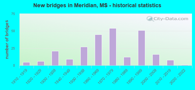
- New bridges - historical statistics
- 51910-1919
- 61920-1929
- 211930-1939
- 91940-1949
- 271950-1959
- 451960-1969
- 541970-1979
- 121980-1989
- 511990-1999
- 162000-2009
- 82010-2019
- 12020-2022

- Reconstructed bridges - Historical Statistics
- 31960-1969
- 01970-1979
- 11980-1989
- 11990-1999
- 02000-2009
- 62010-2019


- Bridge Condition - Deck
- 0.7%Excellent
- 15.0%Very good
- 43.1%Good
- 22.2%Satisfactory
- 17.6%Fair
- 1.3%Poor

- Bridge Condition - Superstructure
- 0.7%Excellent
- 40.5%Very good
- 24.2%Good
- 15.7%Satisfactory
- 16.3%Fair
- 2.6%Poor

- Bridge Condition - Substructure
- 35.9%Excellent
- 25.5%Very good
- 20.3%Good
- 13.1%Satisfactory
- 3.9%Fair
- 1.3%Poor
- 0.7%Failed

- Bridge Condition - Channel
- 22.8%Very good
- 24.7%Good
- 23.4%Satisfactory
- 20.3%Fair
- 8.2%Poor
- 0.6%Serious

- Bridge Condition - Culverts
- 33.3%Very good
- 20.4%Good
- 40.7%Satisfactory
- 5.6%Fair
Find on map >> Show street view
Structure Number: 11000200381315A, Location: 8.4 MI E NEWTON CL (Lat: 32.344122, Lng: -88.773600), Route carried "on" structure: Interstate 20, Year Built: 1965, Status: Open, Structure Length: 1.49m (4.89ft), Average Daily Traffic: 12,000 (year 2020), Truck Traffic: 40%, Average Future Daily Traffic: 15,500 (year 2040), Design Load: HS 20+Mod, Features Intersected: BURWELL BRANCH
Minimum Vertical Clearance: 30+ m (98+ ft), Kilometerpoint: 0.632, Lanes on structure: 2, Base Highway Network: Yes (Inventory Route: 2, Subroute: 1), Owner: State Highway Agency, Approaching Roadway Width: 13.4m (44.0ft), Skew: 4 degrees, Material/Design: Concrete, Design/Construction: Culvert, Number Of Spans In Main Unit: 2, Length of Maximum Span: 5.5m (18.0ft)
Condition: Channel: Good, Culverts: Good, Inventory Rating: 97.0 metric tons, Method Used To Determine Inventory Rating: Load Factor (LF), Structural Evaluation: Better than present minimum criteria, Waterway Adequacy: Equal to present desirable criteria, Approach Roadway Alignment: Equal to present desirable criteria, Designated Inspection Frequency: Every 24 months, Inspection Date: April 2021
Find on map >> Show street view
Structure Number: 11000200381315B, Location: 8.4 MI E NEWTON CL (Lat: 32.342814, Lng: -88.774389), Route carried "on" structure: Interstate 20, Year Built: 1965, Status: Open, Structure Length: 16.98m (55.71ft), Average Daily Traffic: 12,000 (year 2020), Truck Traffic: 40%, Average Future Daily Traffic: 15,500 (year 2040), Design Load: HS 20+Mod, Features Intersected: I 59 N RAMP TO I 20 W
Minimum Vertical Clearance: 30+ m (98+ ft), Kilometerpoint: 13.760, Lanes on structure: 2, Lanes under structure: 1, Base Highway Network: Yes (Inventory Route: 2, Subroute: 1), Owner: State Highway Agency, Approaching Roadway Width: 13.4m (44.0ft), Material/Design: Concrete continuous, Design/Construction: Box Beam or Girders - Single/Spread, Number Of Spans In Main Unit: 9, Length of Maximum Span: 27.4m (89.9ft), Curb or Sidewalk Widths: Left: 0.5m (1.6ft), Right: 0.5m (1.6ft), Curb-To-Curb Width: 8.5m (27.9ft), Out-to-Out Width: 10.0m (32.8ft)
Condition: Deck: Fair, Superstructure: Fair, Substructure: Very good, Inventory Rating: 70.0 metric tons, Method Used To Determine Inventory Rating: Load Factor (LF), Structural Evaluation: Somewhat better than minimum adequacy, Deck Geometry: High priority of corrective action, Underclear: Meets minimum limits, Approach Roadway Alignment: Equal to present desirable criteria, Length Of Structure Improvement: 16.98m (55.71ft), Designated Inspection Frequency: Every 24 months, Inspection Date: April 2021, Bridge Improvement Cost: $412,000,000, Roadway Improvement Cost: $200,000,000, Total Project Cost: $612,000,000, Deck Structure Type: Concrete Cast-file-Place
Find on map >> Show street view
Structure Number: 11000200381318B, Location: JCT I 59 I 20 (Lat: 32.343036, Lng: -88.770542), Route carried "on" structure: Interstate 20, Year Built: 1965, Status: Open, Structure Length: 1.49m (4.89ft), Average Daily Traffic: 12,000 (year 2020), Truck Traffic: 40%, Average Future Daily Traffic: 15,500 (year 2040), Design Load: HS 20, Features Intersected: BURWELL BRANCH
Minimum Vertical Clearance: 5.14m (16.86ft), Kilometerpoint: 14.124, Lanes on structure: 2, Base Highway Network: Yes (Inventory Route: 2, Subroute: 1), Owner: State Highway Agency, Approaching Roadway Width: 12.8m (42.0ft), Skew: 4 degrees, Material/Design: Concrete, Design/Construction: Culvert, Number Of Spans In Main Unit: 2, Length of Maximum Span: 5.5m (18.0ft)
Condition: Channel: Very good, Culverts: Very good, Operating Rating: 70.2 metric tons, Method Used To Determine Operating Rating: Load Factor (LF), Inventory Rating: 42.3 metric tons, Method Used To Determine Inventory Rating: Load Factor (LF), Structural Evaluation: Equal to present desirable criteria, Waterway Adequacy: Equal to present desirable criteria, Approach Roadway Alignment: Equal to present desirable criteria, Designated Inspection Frequency: Every 24 months, Inspection Date: April 2021
Find on map >> Show street view
Structure Number: 11000590381438A, Location: 5.5 MI N CLARKE CL (Lat: 32.297886, Lng: -88.805661), Route carried "on" structure: Interstate 59, Year Built: 1965, Status: Open, Structure Length: 7.41m (24.31ft), Average Daily Traffic: 6,000 (year 2020), Truck Traffic: 29%, Average Future Daily Traffic: 7,000 (year 2040), Design Load: HS 20+Mod, Features Intersected: OVER DIRT TRAIL
Minimum Vertical Clearance: 30+ m (98+ ft), Kilometerpoint: 44.431, Lanes on structure: 2, Lanes under structure: 1, Base Highway Network: Yes (Inventory Route: 5, Subroute: 1), Owner: State Highway Agency, Approaching Roadway Width: 13.4m (44.0ft), Material/Design: Prestressed concrete, Design/Construction: Stringer/Multi-beam, Number Of Spans In Main Unit: 4, Length of Maximum Span: 18.3m (60.0ft), Curb or Sidewalk Widths: Left: 0.5m (1.6ft), Right: 0.5m (1.6ft), Curb-To-Curb Width: 8.5m (27.9ft), Out-to-Out Width: 10.0m (32.8ft)
Condition: Deck: Good, Superstructure: Very good, Substructure: Very good, Operating Rating: 72.6 metric tons, Method Used To Determine Operating Rating: Load Factor (LF), Inventory Rating: 43.4 metric tons, Method Used To Determine Inventory Rating: Load Factor (LF), Structural Evaluation: Equal to present desirable criteria, Deck Geometry: High priority of corrective action, Approach Roadway Alignment: Equal to present desirable criteria, Length Of Structure Improvement: 7.41m (24.31ft), Designated Inspection Frequency: Every 24 months, Inspection Date: May 2021, Bridge Improvement Cost: $180,000,000, Roadway Improvement Cost: $200,000,000, Total Project Cost: $380,000,000, Deck Structure Type: Concrete Cast-file-Place
Find on map >> Show street view
Structure Number: 11000590381438B, Location: 5.5 MI N CLARKE CL (Lat: 32.297197, Lng: -88.805069), Route carried "on" structure: Interstate 59, Year Built: 1965, Status: Open, Structure Length: 7.41m (24.31ft), Average Daily Traffic: 6,000 (year 2020), Truck Traffic: 28%, Average Future Daily Traffic: 7,000 (year 2040), Design Load: HS 20+Mod, Features Intersected: OVER DIRT TRAIL
Minimum Vertical Clearance: 30+ m (98+ ft), Kilometerpoint: 8.958, Lanes on structure: 2, Lanes under structure: 1, Base Highway Network: Yes (Inventory Route: 5, Subroute: 1), Owner: State Highway Agency, Approaching Roadway Width: 13.4m (44.0ft), Material/Design: Prestressed concrete, Design/Construction: Stringer/Multi-beam, Number Of Spans In Main Unit: 4, Length of Maximum Span: 18.3m (60.0ft), Curb or Sidewalk Widths: Left: 0.5m (1.6ft), Right: 0.5m (1.6ft), Curb-To-Curb Width: 8.5m (27.9ft), Out-to-Out Width: 10.0m (32.8ft)
Condition: Deck: Good, Superstructure: Very good, Substructure: Very good, Operating Rating: 72.6 metric tons, Method Used To Determine Operating Rating: Load Factor (LF), Inventory Rating: 43.4 metric tons, Method Used To Determine Inventory Rating: Load Factor (LF), Structural Evaluation: Equal to present desirable criteria, Deck Geometry: High priority of corrective action, Approach Roadway Alignment: Equal to present desirable criteria, Length Of Structure Improvement: 7.41m (24.31ft), Designated Inspection Frequency: Every 24 months, Inspection Date: May 2021, Bridge Improvement Cost: $180,000,000, Roadway Improvement Cost: $200,000,000, Total Project Cost: $380,000,000, Deck Structure Type: Concrete Cast-file-Place
Find on map >> Show street view
Structure Number: 11000590381459, Location: 7.4 MI N CLARKE CL (Lat: 32.318225, Lng: -88.786025), Route carried "on" structure: Interstate 59, Year Built: 1965, Status: Open, Structure Length: 0.70m (2.30ft), Average Daily Traffic: 12,000 (year 2020), Truck Traffic: 28%, Average Future Daily Traffic: 14,000 (year 2040), Design Load: HS 20, Features Intersected: CREEK
Minimum Vertical Clearance: 30+ m (98+ ft), Kilometerpoint: 12.059, Lanes on structure: 4, Base Highway Network: Yes (Inventory Route: 5, Subroute: 1), Owner: State Highway Agency, Approaching Roadway Width: 13.4m (44.0ft), Skew: 11 degrees, Material/Design: Concrete, Design/Construction: Culvert, Number Of Spans In Main Unit: 2, Length of Maximum Span: 3.0m (9.8ft)
Condition: Channel: Satisfactory, Culverts: Very good, Structural Evaluation: Equal to present desirable criteria, Waterway Adequacy: Equal to present desirable criteria, Approach Roadway Alignment: Equal to present desirable criteria, Designated Inspection Frequency: Every 24 months, Inspection Date: May 2021
Find on map >> Show street view
Structure Number: 1100059038146, Location: 7.5 MI N CLARKE CL (Lat: 32.319472, Lng: -88.784661), Route carried "on" structure: Interstate 59, Year Built: 1965, Status: Open, Structure Length: 0.88m (2.89ft), Average Daily Traffic: 12,000 (year 2020), Truck Traffic: 28%, Average Future Daily Traffic: 14,000 (year 2040), Design Load: HS 20, Features Intersected: HOG NOSE CREEK
Minimum Vertical Clearance: 30+ m (98+ ft), Kilometerpoint: 12.247, Lanes on structure: 4, Base Highway Network: Yes (Inventory Route: 5, Subroute: 1), Owner: State Highway Agency, Approaching Roadway Width: 13.4m (44.0ft), Skew: 11 degrees, Material/Design: Concrete, Design/Construction: Culvert, Number Of Spans In Main Unit: 2, Length of Maximum Span: 3.7m (12.1ft)
Condition: Channel: Satisfactory, Culverts: Very good, Structural Evaluation: Equal to present desirable criteria, Waterway Adequacy: Equal to present desirable criteria, Approach Roadway Alignment: Equal to present desirable criteria, Designated Inspection Frequency: Every 24 months, Inspection Date: May 2021
Find on map >> Show street view
Structure Number: 11000590381478, Location: I 59 SOUTH OVER I 20 WEST (Lat: 32.341825, Lng: -88.771564), Route carried "on" structure: Interstate 59, Year Built: 1965, Status: Open, Structure Length: 10.12m (33.20ft), Average Daily Traffic: 7,800 (year 2020), Truck Traffic: 38%, Average Future Daily Traffic: 7,800 (year 2040), Design Load: HS 20+Mod, Features Intersected: I 59 NORTH TO I 20 WEST
Minimum Vertical Clearance: 30+ m (98+ ft), Kilometerpoint: 38.180, Lanes on structure: 2, Lanes under structure: 1, Base Highway Network: Yes (Inventory Route: 5, Subroute: 1), Owner: State Highway Agency, Approaching Roadway Width: 13.4m (44.0ft), Material/Design: Concrete continuous, Design/Construction: Box Beam or Girders - Single/Spread, Number Of Spans In Main Unit: 1, Number Of Approach Spans: 4, Length of Maximum Span: 24.4m (80.1ft), Curb or Sidewalk Widths: Left: 0.5m (1.6ft), Right: 0.5m (1.6ft), Curb-To-Curb Width: 8.5m (27.9ft), Out-to-Out Width: 10.0m (32.8ft)
Condition: Deck: Fair, Superstructure: Fair, Substructure: Good, Inventory Rating: 72.9 metric tons, Method Used To Determine Inventory Rating: Load Factor (LF), Structural Evaluation: Somewhat better than minimum adequacy, Deck Geometry: High priority of corrective action, Underclear: Equal to present desirable criteria, Approach Roadway Alignment: Equal to present desirable criteria, Length Of Structure Improvement: 10.12m (33.20ft), Designated Inspection Frequency: Every 24 months, Inspection Date: May 2021, Bridge Improvement Cost: $246,000,000, Roadway Improvement Cost: $200,000,000, Total Project Cost: $446,000,000, Deck Structure Type: Concrete Cast-file-Place
Find on map >> Show street view
Structure Number: 11000590381479A, Location: I 59 SOUTH OVER I 20 EAST (Lat: 32.343478, Lng: -88.769856), Route carried "on" structure: Interstate 59, Year Built: 1965, Status: Open, Structure Length: 13.93m (45.70ft), Average Daily Traffic: 7,800 (year 2020), Truck Traffic: 38%, Average Future Daily Traffic: 7,800 (year 2040), Design Load: HS 20+Mod, Features Intersected: I 20 EAST
Minimum Vertical Clearance: 30+ m (98+ ft), Kilometerpoint: 37.935, Lanes on structure: 2, Lanes under structure: 2, Base Highway Network: Yes (Inventory Route: 5, Subroute: 1), Owner: State Highway Agency, Approaching Roadway Width: 13.4m (44.0ft), Material/Design: Concrete continuous, Design/Construction: Box Beam or Girders - Single/Spread, Number Of Spans In Main Unit: 7, Length of Maximum Span: 32.0m (105.0ft), Curb or Sidewalk Widths: Left: 0.5m (1.6ft), Right: 0.5m (1.6ft), Curb-To-Curb Width: 8.5m (27.9ft), Out-to-Out Width: 10.0m (32.8ft)
Condition: Deck: Fair, Superstructure: Fair, Substructure: Very good, Inventory Rating: 65.1 metric tons, Method Used To Determine Inventory Rating: Load Factor (LF), Structural Evaluation: Somewhat better than minimum adequacy, Deck Geometry: High priority of corrective action, Underclear: Meets minimum limits, Approach Roadway Alignment: Equal to present desirable criteria, Length Of Structure Improvement: 13.93m (45.70ft), Designated Inspection Frequency: Every 24 months, Inspection Date: May 2021, Bridge Improvement Cost: $338,000,000, Roadway Improvement Cost: $200,000,000, Total Project Cost: $538,000,000, Deck Structure Type: Concrete Cast-file-Place
Find on map >> Show street view
Structure Number: 11000590381479B, Location: 9.5 MI N CLARKE CL (Lat: 32.342250, Lng: -88.769353), Route carried "on" structure: Interstate 59, Year Built: 1965, Status: Open, Structure Length: 1.04m (3.41ft), Average Daily Traffic: 7,800 (year 2020), Truck Traffic: 30%, Average Future Daily Traffic: 9,800 (year 2040), Design Load: HS 20+Mod, Features Intersected: BURWELL BRANCH
Minimum Vertical Clearance: 30+ m (98+ ft), Kilometerpoint: 15.319, Lanes on structure: 2, Base Highway Network: Yes (Inventory Route: 5, Subroute: 1), Owner: State Highway Agency, Approaching Roadway Width: 13.4m (44.0ft), Material/Design: Concrete, Design/Construction: Culvert, Number Of Spans In Main Unit: 2, Length of Maximum Span: 4.9m (16.1ft)
Condition: Channel: Very good, Culverts: Very good, Inventory Rating: 97.0 metric tons, Method Used To Determine Inventory Rating: Load Factor (LF), Structural Evaluation: Equal to present desirable criteria, Waterway Adequacy: Equal to present desirable criteria, Approach Roadway Alignment: Equal to present desirable criteria, Designated Inspection Frequency: Every 24 months, Inspection Date: May 2021, Deck Structure Type: Concrete Cast-file-Place
Find on map >> Show street view
Structure Number: 11000590381483A, Location: 0.8 MI E JCT I 20/I 59 (Lat: 32.345558, Lng: -88.763231), Route carried "on" structure: Interstate 59, Year Built: 2008, Status: Open, Structure Length: 6.14m (20.14ft), Average Daily Traffic: 17,000 (year 2020), Truck Traffic: 38%, Average Future Daily Traffic: 21,500 (year 2040), Design Load: HS 20, Features Intersected: RELIEF
Minimum Vertical Clearance: 30+ m (98+ ft), Kilometerpoint: 37.266, Lanes on structure: 3, Base Highway Network: Yes (Inventory Route: 5, Subroute: 1), Owner: State Highway Agency, Approaching Roadway Width: 16.5m (54.1ft), Skew: 10 degrees, Material/Design: Prestressed concrete, Design/Construction: Stringer/Multi-beam, Number Of Spans In Main Unit: 1, Number Of Approach Spans: 5, Length of Maximum Span: 12.2m (40.0ft), Curb-To-Curb Width: 16.5m (54.1ft), Out-to-Out Width: 17.4m (57.1ft)
Condition: Deck: Very good, Superstructure: Very good, Substructure: Very good, Channel: Very good, Operating Rating: 58.9 metric tons, Method Used To Determine Operating Rating: Load Factor (LF), Inventory Rating: 35.3 metric tons, Method Used To Determine Inventory Rating: Load Factor (LF), Structural Evaluation: Equal to present desirable criteria, Deck Geometry: Equal to present minimum criteria, Waterway Adequacy: Equal to present desirable criteria, Approach Roadway Alignment: Equal to present desirable criteria, Designated Inspection Frequency: Every 24 months, Inspection Date: May 2021, Deck Structure Type: Concrete Cast-file-Place
Find on map >> Show street view
Structure Number: 11000590381484B, Location: 0.8 MI E JCT I 59 I 20 (Lat: 32.344919, Lng: -88.763683), Route carried "on" structure: Interstate 59, Year Built: 1965, Status: Open, Structure Length: 6.10m (20.01ft), Average Daily Traffic: 17,000 (year 2020), Truck Traffic: 38%, Average Future Daily Traffic: 21,500 (year 2040), Design Load: HS 20+Mod, Features Intersected: RELIEF
Minimum Vertical Clearance: 30+ m (98+ ft), Kilometerpoint: 15.931, Lanes on structure: 3, Base Highway Network: Yes (Inventory Route: 5, Subroute: 1), Owner: State Highway Agency, Approaching Roadway Width: 20.1m (65.9ft), Material/Design: Prestressed concrete, Design/Construction: Stringer/Multi-beam, Number Of Spans In Main Unit: 5, Length of Maximum Span: 12.2m (40.0ft), Curb or Sidewalk Widths: Left: 0.2m (0.7ft), Right: 0.2m (0.7ft), Curb-To-Curb Width: 20.1m (65.9ft), Out-to-Out Width: 21.0m (68.9ft)
Condition: Deck: Good, Superstructure: Very good, Substructure: Very good, Channel: Very good, Operating Rating: 60.3 metric tons, Method Used To Determine Operating Rating: Load Factor (LF), Inventory Rating: 36.5 metric tons, Method Used To Determine Inventory Rating: Load Factor (LF), Structural Evaluation: Equal to present desirable criteria, Deck Geometry: Superior to present desirable criteria, Waterway Adequacy: Equal to present desirable criteria, Approach Roadway Alignment: Equal to present desirable criteria, Designated Inspection Frequency: Every 24 months, Inspection Date: May 2021, Deck Structure Type: Concrete Cast-file-Place
Find on map >> Show street view
Structure Number: 11000590381485B, Location: 0.9 MI E JCT I 59 I 20 (Lat: 32.345683, Lng: -88.761336), Route carried "on" structure: Interstate 59, Year Built: 1965, Year Reconstructed: 2010, Status: Open, Structure Length: 4.88m (16.01ft), Average Daily Traffic: 17,000 (year 2020), Truck Traffic: 38%, Average Future Daily Traffic: 21,500 (year 2040), Design Load: HS 20+Mod, Features Intersected: RELIEF
Minimum Vertical Clearance: 30+ m (98+ ft), Kilometerpoint: 16.167, Lanes on structure: 3, Base Highway Network: Yes (Inventory Route: 5, Subroute: 1), Owner: State Highway Agency, Approaching Roadway Width: 20.1m (65.9ft), Material/Design: Prestressed concrete, Design/Construction: Stringer/Multi-beam, Number Of Spans In Main Unit: 4, Length of Maximum Span: 12.2m (40.0ft), Curb-To-Curb Width: 20.1m (65.9ft), Out-to-Out Width: 21.0m (68.9ft)
Condition: Deck: Fair, Superstructure: Very good, Substructure: Very good, Channel: Very good, Operating Rating: 60.3 metric tons, Method Used To Determine Operating Rating: Load Factor (LF), Inventory Rating: 36.5 metric tons, Method Used To Determine Inventory Rating: Load Factor (LF), Structural Evaluation: Equal to present desirable criteria, Deck Geometry: Superior to present desirable criteria, Waterway Adequacy: Equal to present desirable criteria, Approach Roadway Alignment: Equal to present desirable criteria, Designated Inspection Frequency: Every 24 months, Inspection Date: May 2021, Deck Structure Type: Concrete Cast-file-Place
Find on map >> Show street view
Structure Number: 11000590381486A, Location: 0.9 MI E JCT I 59/I 20 (Lat: 32.346153, Lng: -88.760953), Route carried "on" structure: Interstate 59, Year Built: 2008, Status: Open, Structure Length: 4.93m (16.17ft), Average Daily Traffic: 17,000 (year 2020), Truck Traffic: 38%, Average Future Daily Traffic: 21,500 (year 2040), Design Load: HS 20, Features Intersected: RELIEF
Minimum Vertical Clearance: 30+ m (98+ ft), Kilometerpoint: 37.042, Lanes on structure: 3, Base Highway Network: Yes (Inventory Route: 5, Subroute: 1), Owner: State Highway Agency, Approaching Roadway Width: 16.5m (54.1ft), Skew: 10 degrees, Material/Design: Prestressed concrete continuous, Design/Construction: Stringer/Multi-beam, Number Of Spans In Main Unit: 4, Length of Maximum Span: 12.2m (40.0ft), Curb-To-Curb Width: 16.5m (54.1ft), Out-to-Out Width: 17.4m (57.1ft)
Condition: Deck: Very good, Superstructure: Very good, Substructure: Very good, Channel: Very good, Operating Rating: 58.9 metric tons, Method Used To Determine Operating Rating: Load Factor (LF), Inventory Rating: 35.3 metric tons, Method Used To Determine Inventory Rating: Load Factor (LF), Structural Evaluation: Equal to present desirable criteria, Deck Geometry: Equal to present minimum criteria, Waterway Adequacy: Equal to present desirable criteria, Approach Roadway Alignment: Equal to present desirable criteria, Designated Inspection Frequency: Every 24 months, Inspection Date: May 2021, Deck Structure Type: Concrete Cast-file-Place
Find on map >> Show street view
Structure Number: 11000590381490B, Location: 1.4 MI E JCT I 59/I 20 (Lat: 32.347900, Lng: -88.753317), Route carried "on" structure: Interstate 59, Year Built: 1965, Year Reconstructed: 2010, Status: Open, Structure Length: 13.11m (43.01ft), Average Daily Traffic: 17,000 (year 2020), Truck Traffic: 38%, Average Future Daily Traffic: 21,500 (year 2040), Design Load: HS 20+Mod, Features Intersected: OKATIBEE CREEK
Minimum Vertical Clearance: 30+ m (98+ ft), Kilometerpoint: 16.962, Lanes on structure: 2, Base Highway Network: Yes (Inventory Route: 5, Subroute: 1), Owner: State Highway Agency, Approaching Roadway Width: 16.4m (53.8ft), Material/Design: Prestressed concrete, Design/Construction: Stringer/Multi-beam, Number Of Spans In Main Unit: 1, Number Of Approach Spans: 9, Length of Maximum Span: 21.3m (69.9ft), Curb-To-Curb Width: 16.4m (53.8ft), Out-to-Out Width: 17.3m (56.8ft)
Condition: Deck: Good, Superstructure: Very good, Substructure: Very good, Channel: Very good, Operating Rating: 70.3 metric tons, Method Used To Determine Operating Rating: Load Factor (LF), Inventory Rating: 40.1 metric tons, Method Used To Determine Inventory Rating: Load Factor (LF), Structural Evaluation: Equal to present desirable criteria, Deck Geometry: Superior to present desirable criteria, Waterway Adequacy: Equal to present desirable criteria, Approach Roadway Alignment: Equal to present desirable criteria, Designated Inspection Frequency: Every 24 months, Inspection Date: May 2021, Deck Structure Type: Concrete Cast-file-Place
Find on map >> Show street view
Structure Number: 11000590381491A, Location: 1.4 MI E JCT I 59/I 20 (Lat: 32.348486, Lng: -88.752025), Route carried "on" structure: Interstate 59, Year Built: 2008, Status: Open, Structure Length: 16.81m (55.15ft), Average Daily Traffic: 17,000 (year 2020), Truck Traffic: 38%, Average Future Daily Traffic: 21,500 (year 2040), Design Load: HS 20, Features Intersected: OKATIBEE CREEK
Minimum Vertical Clearance: 30+ m (98+ ft), Kilometerpoint: 36.162, Lanes on structure: 3, Base Highway Network: Yes (Inventory Route: 5, Subroute: 1), Owner: State Highway Agency, Approaching Roadway Width: 16.5m (54.1ft), Skew: 10 degrees, Material/Design: Prestressed concrete, Design/Construction: Stringer/Multi-beam, Number Of Spans In Main Unit: 1, Number Of Approach Spans: 11, Length of Maximum Span: 33.5m (109.9ft), Curb-To-Curb Width: 16.5m (54.1ft), Out-to-Out Width: 17.4m (57.1ft)
Condition: Deck: Very good, Superstructure: Very good, Substructure: Very good, Channel: Very good, Operating Rating: 58.9 metric tons, Method Used To Determine Operating Rating: Load Factor (LF), Inventory Rating: 35.2 metric tons, Method Used To Determine Inventory Rating: Load Factor (LF), Structural Evaluation: Equal to present desirable criteria, Deck Geometry: Equal to present minimum criteria, Waterway Adequacy: Equal to present desirable criteria, Approach Roadway Alignment: Equal to present desirable criteria, Designated Inspection Frequency: Every 24 months, Inspection Date: May 2021, Deck Structure Type: Concrete Cast-file-Place
Find on map >> Show street view
Structure Number: 11000590381497, Location: 0.6 MI W JCT I 59 US 11 (Lat: 32.349989, Lng: -88.745931), Route carried "on" structure: Interstate 59, Year Built: 1965, Year Reconstructed: 1974, Status: Open, Structure Length: 16.86m (55.31ft), Average Daily Traffic: 34,000 (year 2020), Truck Traffic: 38%, Average Future Daily Traffic: 43,000 (year 2040), Design Load: HS 20+Mod, Features Intersected: 65TH AVE, KCS RR
Minimum Vertical Clearance: 30+ m (98+ ft), Kilometerpoint: 17.696, Lanes on structure: 4, Lanes under structure: 2, Base Highway Network: Yes (Inventory Route: 5, Subroute: 1), Owner: State Highway Agency, Approaching Roadway Width: 21.9m (71.9ft), Skew: 34 degrees, Material/Design: Prestressed concrete, Design/Construction: Stringer/Multi-beam, Number Of Spans In Main Unit: 3, Number Of Approach Spans: 8, Length of Maximum Span: 21.3m (69.9ft), Curb or Sidewalk Widths: Left: 0.6m (2.0ft), Right: 0.6m (2.0ft), Curb-To-Curb Width: 17.0m (55.8ft), Out-to-Out Width: 18.9m (62.0ft)
Condition: Deck: Good, Superstructure: Very good, Substructure: Good, Operating Rating: 54.8 metric tons, Method Used To Determine Operating Rating: Load Factor (LF), Inventory Rating: 32.7 metric tons, Method Used To Determine Inventory Rating: Load Factor (LF), Structural Evaluation: Better than present minimum criteria, Deck Geometry: Meets minimum limits, Underclear: High priority of corrective action, Approach Roadway Alignment: Equal to present desirable criteria, Length Of Structure Improvement: 16.86m (55.31ft), Designated Inspection Frequency: Every 24 months, Inspection Date: May 2021, Bridge Improvement Cost: $315,000,000, Roadway Improvement Cost: $200,000,000, Total Project Cost: $515,000,000, Deck Structure Type: Concrete Cast-file-Place
Find on map >> Show street view
Structure Number: 11000590381503, Location: I20/I59 OVER US 11 SOUTH (Lat: 32.349650, Lng: -88.735297), Route carried "on" structure: Interstate 59, Year Built: 1974, Status: Open, Structure Length: 9.51m (31.20ft), Average Daily Traffic: 54,000 (year 2020), Truck Traffic: 18%, Average Future Daily Traffic: 68,000 (year 2040), Design Load: HS 20+Mod, Features Intersected: US 11, NORFOLK S RR
Minimum Vertical Clearance: 30+ m (98+ ft), Kilometerpoint: 18.728, Lanes on structure: 6, Lanes under structure: 4, Base Highway Network: Yes (Inventory Route: 5, Subroute: 1), Owner: State Highway Agency, Approaching Roadway Width: 32.0m (105.0ft), Skew: 34 degrees, Material/Design: Prestressed concrete, Design/Construction: Stringer/Multi-beam, Number Of Spans In Main Unit: 1, Number Of Approach Spans: 3, Length of Maximum Span: 33.5m (109.9ft), Curb-To-Curb Width: 30.4m (99.7ft), Out-to-Out Width: 32.2m (105.6ft)
Condition: Deck: Fair, Superstructure: Very good, Substructure: Very good, Operating Rating: 58.9 metric tons, Method Used To Determine Operating Rating: Load Factor (LF), Inventory Rating: 34.4 metric tons, Method Used To Determine Inventory Rating: Load Factor (LF), Structural Evaluation: Equal to present desirable criteria, Deck Geometry: Superior to present desirable criteria, Underclear: Better than present minimum criteria, Approach Roadway Alignment: Equal to present desirable criteria, Designated Inspection Frequency: Every 24 months, Inspection Date: May 2021, Deck Structure Type: Concrete Cast-file-Place
Find on map >> Show street view
Structure Number: 11000590381509C, Location: 0.6 MI E US 11 (Lat: 32.349008, Lng: -88.725328), Route carried "on" structure: Interstate 59, Year Built: 1973, Status: Open, Structure Length: 11.64m (38.19ft), Average Daily Traffic: 54,000 (year 2020), Truck Traffic: 18%, Average Future Daily Traffic: 68,000 (year 2040), Design Load: HS 20+Mod, Features Intersected: SOWASHEE CREEK
Minimum Vertical Clearance: 30+ m (98+ ft), Kilometerpoint: 19.674, Lanes on structure: 4, Base Highway Network: Yes (Inventory Route: 5, Subroute: 1), Owner: State Highway Agency, Approaching Roadway Width: 27.4m (89.9ft), Skew: 32 degrees, Material/Design: Prestressed concrete, Design/Construction: Stringer/Multi-beam, Number Of Spans In Main Unit: 1, Number Of Approach Spans: 6, Length of Maximum Span: 24.4m (80.1ft), Curb-To-Curb Width: 25.6m (84.0ft), Out-to-Out Width: 27.4m (89.9ft)
Condition: Deck: Fair, Superstructure: Very good, Substructure: Good, Channel: Very good, Operating Rating: 64.6 metric tons, Method Used To Determine Operating Rating: Load Factor (LF), Inventory Rating: 36.4 metric tons, Method Used To Determine Inventory Rating: Load Factor (LF), Structural Evaluation: Better than present minimum criteria, Deck Geometry: Superior to present desirable criteria, Waterway Adequacy: Equal to present desirable criteria, Approach Roadway Alignment: Equal to present desirable criteria, Designated Inspection Frequency: Every 24 months, Inspection Date: May 2021, Deck Structure Type: Concrete Cast-file-Place
Find on map >> Show street view
Structure Number: 11000590381512, Location: 0.9 MI E US 11 (Lat: 32.349006, Lng: -88.720286), Route carried "on" structure: Interstate 59, Year Built: 1973, Status: Open, Structure Length: 17.47m (57.32ft), Average Daily Traffic: 43,000 (year 2020), Truck Traffic: 27%, Average Future Daily Traffic: 54,000 (year 2040), Design Load: HS 20+Mod, Features Intersected: KCS RR
Minimum Vertical Clearance: 30+ m (98+ ft), Kilometerpoint: 20.149, Lanes on structure: 5, Base Highway Network: Yes (Inventory Route: 5, Subroute: 1), Owner: State Highway Agency, Approaching Roadway Width: 29.9m (98.1ft), Skew: 34 degrees, Material/Design: Prestressed concrete, Design/Construction: Stringer/Multi-beam, Number Of Spans In Main Unit: 9, Length of Maximum Span: 26.8m (87.9ft), Curb-To-Curb Width: 25.6m (84.0ft), Out-to-Out Width: 30.1m (98.8ft)
Condition: Deck: Fair, Superstructure: Very good, Substructure: Fair, Operating Rating: 59.7 metric tons, Method Used To Determine Operating Rating: Load Factor (LF), Inventory Rating: 30.4 metric tons, Method Used To Determine Inventory Rating: Load Factor (LF), Structural Evaluation: Somewhat better than minimum adequacy, Deck Geometry: Better than present minimum criteria, Underclear: High priority of replacement, Approach Roadway Alignment: Equal to present desirable criteria, Length Of Structure Improvement: 21.60m (70.87ft), Designated Inspection Frequency: Every 24 months, Inspection Date: June 2021, Bridge Improvement Cost: $999,999,000, Roadway Improvement Cost: $422,000,000, Total Project Cost: $999,999,000, Deck Structure Type: Concrete Cast-file-Place
Find on map >> Show street view
Structure Number: 11000590381522, Location: 1.9 MI E US 11 (Lat: 32.348975, Lng: -88.702622), Route carried "on" structure: Interstate 59, Year Built: 1973, Status: Open, Structure Length: 27.04m (88.71ft), Average Daily Traffic: 53,000 (year 2020), Truck Traffic: 20%, Average Future Daily Traffic: 67,000 (year 2040), Design Load: HS 20+Mod, Features Intersected: GRAND AVE
Minimum Vertical Clearance: 30+ m (98+ ft), Kilometerpoint: 21.813, Lanes on structure: 4, Lanes under structure: 4, Base Highway Network: Yes (Inventory Route: 5, Subroute: 1), Owner: State Highway Agency, Approaching Roadway Width: 25.0m (82.0ft), Skew: 30 degrees, Material/Design: Prestressed concrete, Design/Construction: Stringer/Multi-beam, Number Of Spans In Main Unit: 11, Length of Maximum Span: 33.5m (109.9ft), Curb-To-Curb Width: 23.4m (76.8ft), Out-to-Out Width: 25.2m (82.7ft)
Condition: Deck: Satisfactory, Superstructure: Very good, Substructure: Very good, Operating Rating: 62.8 metric tons, Method Used To Determine Operating Rating: Load Factor (LF), Inventory Rating: 28.6 metric tons, Method Used To Determine Inventory Rating: Load Factor (LF), Structural Evaluation: Better than present minimum criteria, Deck Geometry: Superior to present desirable criteria, Underclear: Equal to present minimum criteria, Approach Roadway Alignment: Equal to present desirable criteria, Designated Inspection Frequency: Every 24 months, Inspection Date: June 2021, Deck Structure Type: Concrete Cast-file-Place
Find on map >> Show street view
Structure Number: 11000590381530B, Location: I 20/I 59 OVER SR 145 (Lat: 32.353228, Lng: -88.691336), Route carried "on" structure: Interstate 59, Year Built: 1957, Year Reconstructed: 1973, Status: Open, Structure Length: 4.88m (16.01ft), Average Daily Traffic: 53,000 (year 2020), Truck Traffic: 20%, Average Future Daily Traffic: 67,000 (year 2040), Design Load: HS 20, Features Intersected: SR 145
Minimum Vertical Clearance: 30+ m (98+ ft), Kilometerpoint: 22.999, Lanes on structure: 6, Lanes under structure: 4, Base Highway Network: Yes (Inventory Route: 5, Subroute: 1), Owner: State Highway Agency, Approaching Roadway Width: 29.9m (98.1ft), Skew: 30 degrees, Material/Design: Steel, Design/Construction: Stringer/Multi-beam, Number Of Spans In Main Unit: 1, Number Of Approach Spans: 2, Length of Maximum Span: 24.4m (80.1ft), Curb-To-Curb Width: 28.4m (93.2ft), Out-to-Out Width: 30.1m (98.8ft)
Condition: Deck: Good, Superstructure: Good, Substructure: Good, Operating Rating: 44.7 metric tons, Method Used To Determine Operating Rating: Load Factor (LF), Inventory Rating: 26.8 metric tons, Method Used To Determine Inventory Rating: Load Factor (LF), Structural Evaluation: Equal to present minimum criteria, Deck Geometry: Better than present minimum criteria, Underclear: High priority of replacement, Approach Roadway Alignment: Equal to present desirable criteria, Length Of Structure Improvement: 6.31m (20.70ft), Designated Inspection Frequency: Every 24 months, Other Special Inspection Frequency: Every 24 months, Inspection Date: June 2021, Other Special Inspection Date: July 2020, Bridge Improvement Cost: $999,999,000, Roadway Improvement Cost: $129,000,000, Total Project Cost: $999,999,000, Deck Structure Type: Concrete Cast-file-Place
Find on map >> Show street view
Structure Number: 11000590381532, Location: 0.2 MI E SR 145 SOUTH (Lat: 32.355053, Lng: -88.688478), Route carried "on" structure: Interstate 59, Year Built: 1949, Status: Open, Structure Length: 0.94m (3.08ft), Average Daily Traffic: 38,000 (year 2020), Truck Traffic: 35%, Average Future Daily Traffic: 48,000 (year 2040), Design Load: H 15, Features Intersected: STREAM
Minimum Vertical Clearance: 30+ m (98+ ft), Kilometerpoint: 23.335, Lanes on structure: 11, Base Highway Network: Yes (Inventory Route: 5, Subroute: 1), Owner: State Highway Agency, Approaching Roadway Width: 12.8m (42.0ft), Skew: 30 degrees, Material/Design: Concrete, Design/Construction: Culvert, Number Of Spans In Main Unit: 2, Length of Maximum Span: 4.3m (14.1ft)
Condition: Channel: Fair, Culverts: Very good, Operating Rating: 71.1 metric tons, Method Used To Determine Operating Rating: Load Factor (LF), Inventory Rating: 43.2 metric tons, Method Used To Determine Inventory Rating: Load Factor (LF), Structural Evaluation: Equal to present desirable criteria, Waterway Adequacy: Equal to present minimum criteria, Approach Roadway Alignment: Equal to present desirable criteria, Length Of Structure Improvement: 0.94m (3.08ft), Designated Inspection Frequency: Every 24 months, Inspection Date: June 2021, Bridge Improvement Cost: $70,000,000, Roadway Improvement Cost: $200,000,000, Total Project Cost: $270,000,000
Find on map >> Show street view
Structure Number: 11000590381534, Location: 0.4 MI E SR 145 SOUTH (Lat: 32.357072, Lng: -88.685347), Route carried "on" structure: Interstate 59, Year Built: 1973, Status: Open, Structure Length: 37.12m (121.78ft), Average Daily Traffic: 38,000 (year 2020), Truck Traffic: 35%, Average Future Daily Traffic: 48,000 (year 2040), Design Load: HS 20+Mod, Features Intersected: M AND B RR, FRT RD CON
Minimum Vertical Clearance: 30+ m (98+ ft), Kilometerpoint: 23.706, Lanes on structure: 4, Lanes under structure: 4, Base Highway Network: Yes (Inventory Route: 5, Subroute: 1), Owner: State Highway Agency, Approaching Roadway Width: 23.4m (76.8ft), Skew: 30 degrees, Material/Design: Prestressed concrete, Design/Construction: Stringer/Multi-beam, Number Of Spans In Main Unit: 17, Length of Maximum Span: 24.4m (80.1ft), Curb-To-Curb Width: 23.4m (76.8ft), Out-to-Out Width: 25.2m (82.7ft)
Condition: Deck: Fair, Superstructure: Very good, Substructure: Very good, Operating Rating: 59.2 metric tons, Method Used To Determine Operating Rating: Load Factor (LF), Inventory Rating: 29.2 metric tons, Method Used To Determine Inventory Rating: Load Factor (LF), Structural Evaluation: Better than present minimum criteria, Deck Geometry: Superior to present desirable criteria, Underclear: Equal to present minimum criteria, Approach Roadway Alignment: Equal to present desirable criteria, Designated Inspection Frequency: Every 24 months, Inspection Date: June 2021, Deck Structure Type: Concrete Cast-file-Place
Find on map >> Show street view
Structure Number: 11000590381542, Location: 1.2 MI E SR 145 SOUTH (Lat: 32.364367, Lng: -88.675394), Route carried "on" structure: Interstate 59, Year Built: 1949, Status: Open, Structure Length: 0.79m (2.59ft), Average Daily Traffic: 38,000 (year 2020), Truck Traffic: 35%, Average Future Daily Traffic: 48,000 (year 2040), Design Load: HS 20, Features Intersected: RELIEF
Minimum Vertical Clearance: 30+ m (98+ ft), Kilometerpoint: 24.948, Lanes on structure: 8, Base Highway Network: Yes (Inventory Route: 5, Subroute: 1), Owner: State Highway Agency, Approaching Roadway Width: 12.8m (42.0ft), Skew: 30 degrees, Material/Design: Concrete, Design/Construction: Culvert, Number Of Spans In Main Unit: 1, Length of Maximum Span: 7.9m (25.9ft)
Condition: Channel: Satisfactory, Culverts: Very good, Inventory Rating: 81.9 metric tons, Method Used To Determine Inventory Rating: Load Factor (LF), Structural Evaluation: Equal to present desirable criteria, Waterway Adequacy: Equal to present minimum criteria, Approach Roadway Alignment: Equal to present desirable criteria, Length Of Structure Improvement: 0.91m (2.99ft), Designated Inspection Frequency: Every 24 months, Inspection Date: June 2021, Bridge Improvement Cost: $49,000,000, Roadway Improvement Cost: $200,000,000, Total Project Cost: $298,000,000
Find on map >> Show street view
Structure Number: 11000590381544A, Location: BONITA INTERCHANGE (Lat: 32.367375, Lng: -88.672567), Route carried "on" structure: Interstate 59, Year Built: 1961, Status: Open, Structure Length: 7.50m (24.61ft), Average Daily Traffic: 19,000 (year 2020), Truck Traffic: 35%, Average Future Daily Traffic: 24,000 (year 2040), Design Load: HS 20+Mod, Features Intersected: SR 19 SOUTH/SR 39 NORTH
Minimum Vertical Clearance: 30+ m (98+ ft), Kilometerpoint: 27.893, Lanes on structure: 2, Lanes under structure: 6, Base Highway Network: Yes (Inventory Route: 5, Subroute: 1), Owner: State Highway Agency, Approaching Roadway Width: 13.4m (44.0ft), Skew: 3 degrees, Material/Design: Prestressed concrete, Design/Construction: Stringer/Multi-beam, Number Of Spans In Main Unit: 4, Length of Maximum Span: 21.3m (69.9ft), Curb or Sidewalk Widths: Left: 0.5m (1.6ft), Right: 0.5m (1.6ft), Curb-To-Curb Width: 8.5m (27.9ft), Out-to-Out Width: 10.0m (32.8ft)
Condition: Deck: Good, Superstructure: Fair, Substructure: Very good, Operating Rating: 64.5 metric tons, Method Used To Determine Operating Rating: Load Factor (LF), Inventory Rating: 38.6 metric tons, Method Used To Determine Inventory Rating: Load Factor (LF), Structural Evaluation: Somewhat better than minimum adequacy, Deck Geometry: High priority of corrective action, Underclear: Meets minimum limits, Approach Roadway Alignment: Equal to present desirable criteria, Length Of Structure Improvement: 7.50m (24.61ft), Designated Inspection Frequency: Every 24 months, Inspection Date: June 2021, Bridge Improvement Cost: $112,000,000, Roadway Improvement Cost: $200,000,000, Total Project Cost: $312,000,000, Deck Structure Type: Concrete Cast-file-Place
Find on map >> Show street view
Structure Number: 11000590381544B, Location: BONITA INTERCHANGE (Lat: 32.366811, Lng: -88.672761), Route carried "on" structure: Interstate 59, Year Built: 1961, Status: Open, Structure Length: 7.50m (24.61ft), Average Daily Traffic: 19,000 (year 2020), Truck Traffic: 35%, Average Future Daily Traffic: 24,000 (year 2040), Design Load: HS 20+Mod, Features Intersected: SR 19 SOUTH/SR 39 NORTH
Minimum Vertical Clearance: 30+ m (98+ ft), Kilometerpoint: 25.315, Lanes on structure: 3, Lanes under structure: 5, Base Highway Network: Yes (Inventory Route: 5, Subroute: 1), Owner: State Highway Agency, Approaching Roadway Width: 17.1m (56.1ft), Skew: 3 degrees, Material/Design: Prestressed concrete, Design/Construction: Stringer/Multi-beam, Number Of Spans In Main Unit: 4, Length of Maximum Span: 21.3m (69.9ft), Curb or Sidewalk Widths: Left: 0.5m (1.6ft), Right: 0.5m (1.6ft), Curb-To-Curb Width: 12.2m (40.0ft), Out-to-Out Width: 13.7m (44.9ft)
Condition: Deck: Good, Superstructure: Good, Substructure: Very good, Operating Rating: 65.3 metric tons, Method Used To Determine Operating Rating: Load Factor (LF), Inventory Rating: 39.1 metric tons, Method Used To Determine Inventory Rating: Load Factor (LF), Structural Evaluation: Better than present minimum criteria, Deck Geometry: High priority of corrective action, Underclear: Meets minimum limits, Approach Roadway Alignment: Equal to present desirable criteria, Length Of Structure Improvement: 7.50m (24.61ft), Designated Inspection Frequency: Every 24 months, Inspection Date: June 2021, Bridge Improvement Cost: $112,000,000, Roadway Improvement Cost: $200,000,000, Total Project Cost: $312,000,000, Deck Structure Type: Concrete Cast-file-Place
Find on map >> Show street view
Structure Number: 11000590381564A, Location: 1.9 MI N SR 19 SOUTH (Lat: 32.381897, Lng: -88.644603), Route carried "on" structure: Interstate 59, Year Built: 1959, Year Reconstructed: 1972, Status: Open, Structure Length: 4.94m (16.21ft), Average Daily Traffic: 15,500 (year 2020), Truck Traffic: 35%, Average Future Daily Traffic: 19,500 (year 2040), Design Load: HS 20+Mod, Features Intersected: KNIGHT PARKER ROAD
Minimum Vertical Clearance: 30+ m (98+ ft), Kilometerpoint: 24.748, Lanes on structure: 2, Lanes under structure: 2, Base Highway Network: Yes (Inventory Route: 5, Subroute: 1), Owner: State Highway Agency, Approaching Roadway Width: 13.4m (44.0ft), Material/Design: Concrete continuous, Design/Construction: Box Beam or Girders - Single/Spread, Number Of Spans In Main Unit: 3, Length of Maximum Span: 20.4m (66.9ft), Curb or Sidewalk Widths: Left: 0.3m (1.0ft), Right: 0.3m (1.0ft), Curb-To-Curb Width: 11.5m (37.7ft), Out-to-Out Width: 12.7m (41.7ft)
Condition: Deck: Poor, Superstructure: Poor, Substructure: Very good, Operating Rating: 47.3 metric tons, Method Used To Determine Operating Rating: Load Factor (LF), Inventory Rating: 28.5 metric tons, Method Used To Determine Inventory Rating: Load Factor (LF), Structural Evaluation: Meets minimum limits, Deck Geometry: Somewhat better than minimum adequacy, Underclear: Better than present minimum criteria, Approach Roadway Alignment: Equal to present desirable criteria, Designated Inspection Frequency: Every 24 months, Inspection Date: June 2021, Deck Structure Type: Concrete Cast-file-Place
Find on map >> Show street view
Structure Number: 11000590381564B, Location: 1.9 MI N SR 19 SOUTH (Lat: 32.381536, Lng: -88.645222), Route carried "on" structure: Interstate 59, Year Built: 1959, Status: Open, Structure Length: 4.94m (16.21ft), Average Daily Traffic: 15,500 (year 2020), Truck Traffic: 35%, Average Future Daily Traffic: 19,500 (year 2040), Design Load: HS 20+Mod, Features Intersected: KNIGHT PARKER ROAD
Minimum Vertical Clearance: 30+ m (98+ ft), Kilometerpoint: 28.439, Lanes on structure: 2, Lanes under structure: 2, Base Highway Network: Yes (Inventory Route: 5, Subroute: 1), Owner: State Highway Agency, Approaching Roadway Width: 13.4m (44.0ft), Material/Design: Concrete continuous, Design/Construction: Box Beam or Girders - Single/Spread, Number Of Spans In Main Unit: 3, Length of Maximum Span: 20.4m (66.9ft), Curb or Sidewalk Widths: Left: 0.5m (1.6ft), Right: 0.5m (1.6ft), Curb-To-Curb Width: 8.5m (27.9ft), Out-to-Out Width: 10.0m (32.8ft)
Condition: Deck: Poor, Superstructure: Poor, Substructure: Very good, Operating Rating: 47.3 metric tons, Method Used To Determine Operating Rating: Load Factor (LF), Inventory Rating: 28.5 metric tons, Method Used To Determine Inventory Rating: Load Factor (LF), Structural Evaluation: Meets minimum limits, Deck Geometry: High priority of replacement, Underclear: Equal to present minimum criteria, Approach Roadway Alignment: Equal to present desirable criteria, Length Of Structure Improvement: 6.38m (20.93ft), Designated Inspection Frequency: Every 24 months, Inspection Date: June 2021, Bridge Improvement Cost: $584,000,000, Roadway Improvement Cost: $58,000,000, Total Project Cost: $999,999,000, Deck Structure Type: Concrete Cast-file-Place
Find on map >> Show street view
Structure Number: 11000590381589, Location: 2.0 MI N US 45 (Lat: 32.389311, Lng: -88.601911), Route carried "on" structure: Interstate 59, Year Built: 1959, Status: Open, Structure Length: 0.94m (3.08ft), Average Daily Traffic: 25,000 (year 2020), Truck Traffic: 44%, Average Future Daily Traffic: 29,000 (year 2040), Design Load: HS 20, Features Intersected: DITCH
Minimum Vertical Clearance: 30+ m (98+ ft), Kilometerpoint: 32.604, Lanes on structure: 4, Base Highway Network: Yes (Inventory Route: 5, Subroute: 1), Owner: State Highway Agency, Approaching Roadway Width: 13.4m (44.0ft), Material/Design: Concrete, Design/Construction: Culvert, Number Of Spans In Main Unit: 2, Length of Maximum Span: 4.3m (14.1ft)
Condition: Channel: Good, Culverts: Very good, Structural Evaluation: Equal to present desirable criteria, Waterway Adequacy: Better than present minimum criteria, Approach Roadway Alignment: Equal to present desirable criteria, Designated Inspection Frequency: Every 24 months, Inspection Date: June 2021
Find on map >> Show street view
Structure Number: 17000590381509B, Location: 0.6 MI E US 11 (Lat: 32.349533, Lng: -88.723761), Route carried "on" structure: Ramp Interstate 59, Year Built: 1973, Status: Open, Structure Length: 11.64m (38.19ft), Average Daily Traffic: 2,500 (year 2020), Truck Traffic: 18%, Average Future Daily Traffic: 3,200 (year 2040), Design Load: HS 20+Mod, Features Intersected: SOWASHEE CREEK
Minimum Vertical Clearance: 30+ m (98+ ft), Kilometerpoint: 0.224, Lanes on structure: 1, Owner: State Highway Agency, Approaching Roadway Width: 7.3m (24.0ft), Material/Design: Prestressed concrete, Design/Construction: Stringer/Multi-beam, Number Of Spans In Main Unit: 1, Number Of Approach Spans: 6, Length of Maximum Span: 24.4m (80.1ft), Curb-To-Curb Width: 7.2m (23.6ft), Out-to-Out Width: 8.2m (26.9ft)
Condition: Deck: Good, Superstructure: Very good, Substructure: Good, Channel: Very good, Operating Rating: 67.6 metric tons, Method Used To Determine Operating Rating: Load Factor (LF), Inventory Rating: 31.3 metric tons, Method Used To Determine Inventory Rating: Load Factor (LF), Structural Evaluation: Better than present minimum criteria, Deck Geometry: Equal to present minimum criteria, Waterway Adequacy: Equal to present desirable criteria, Approach Roadway Alignment: Equal to present desirable criteria, Designated Inspection Frequency: Every 24 months, Inspection Date: May 2021, Deck Structure Type: Concrete Cast-file-Place
Find on map >> Show street view
Structure Number: 17000590381509D, Location: 0.6 MI E US 11 (Lat: 32.348078, Lng: -88.725581), Route carried "on" structure: Ramp Interstate 59, Year Built: 1973, Status: Open, Structure Length: 13.50m (44.29ft), Average Daily Traffic: 2,400 (year 2020), Truck Traffic: 18%, Average Future Daily Traffic: 3,100 (year 2040), Design Load: HS 20+Mod, Features Intersected: SOWASHEE CREEK
Minimum Vertical Clearance: 30+ m (98+ ft), Kilometerpoint: 0.098, Lanes on structure: 1, Owner: State Highway Agency, Approaching Roadway Width: 7.3m (24.0ft), Skew: 4 degrees, Material/Design: Prestressed concrete, Design/Construction: Stringer/Multi-beam, Number Of Spans In Main Unit: 1, Number Of Approach Spans: 6, Length of Maximum Span: 24.4m (80.1ft), Curb-To-Curb Width: 7.2m (23.6ft), Out-to-Out Width: 8.2m (26.9ft)
Condition: Deck: Fair, Superstructure: Very good, Substructure: Good, Channel: Very good, Operating Rating: 65.6 metric tons, Method Used To Determine Operating Rating: Load Factor (LF), Inventory Rating: 29.9 metric tons, Method Used To Determine Inventory Rating: Load Factor (LF), Structural Evaluation: Better than present minimum criteria, Deck Geometry: Equal to present minimum criteria, Waterway Adequacy: Equal to present desirable criteria, Approach Roadway Alignment: Equal to present desirable criteria, Designated Inspection Frequency: Every 24 months, Inspection Date: May 2021, Deck Structure Type: Concrete Cast-file-Place
Find on map >> Show street view
Structure Number: 18000590381509A, Location: 0.6 MI E US 11 (Lat: 32.350333, Lng: -88.724711), Route carried "on" structure: ServiceOther road 59, Year Built: 1973, Status: Open, Structure Length: 11.64m (38.19ft), Average Daily Traffic: 300 (year 2020), Truck Traffic: 4%, Average Future Daily Traffic: 300 (year 2040), Design Load: HS 20, Features Intersected: SOWASHEE CREEK
Minimum Vertical Clearance: 30+ m (98+ ft), Kilometerpoint: 0.304, Lanes on structure: 2, Owner: State Highway Agency, Approaching Roadway Width: 10.4m (34.1ft), Material/Design: Prestressed concrete, Design/Construction: Stringer/Multi-beam, Number Of Spans In Main Unit: 1, Number Of Approach Spans: 6, Length of Maximum Span: 24.4m (80.1ft), Curb-To-Curb Width: 8.1m (26.6ft), Out-to-Out Width: 9.1m (29.9ft)
Condition: Deck: Good, Superstructure: Very good, Substructure: Very good, Channel: Very good, Operating Rating: 51.7 metric tons, Method Used To Determine Operating Rating: Load Factor (LF), Inventory Rating: 49.0 metric tons, Method Used To Determine Inventory Rating: Load Factor (LF), Structural Evaluation: Equal to present desirable criteria, Deck Geometry: Somewhat better than minimum adequacy, Waterway Adequacy: Equal to present desirable criteria, Approach Roadway Alignment: Equal to present desirable criteria, Designated Inspection Frequency: Every 24 months, Inspection Date: May 2021, Deck Structure Type: Concrete Cast-file-Place
Find on map >> Show street view
Structure Number: 18000590381530A, Location: ON NORTH FRONTAGE RD (Lat: 32.355011, Lng: -88.693117), Route carried "on" structure: ServiceOther road 59, Year Built: 1973, Status: Open, Structure Length: 10.73m (35.20ft), Average Daily Traffic: 1,500 (year 2020), Truck Traffic: 8%, Average Future Daily Traffic: 1,500 (year 2040), Design Load: HS 20+Mod, Features Intersected: SOWASHEE CREEK
Minimum Vertical Clearance: 30+ m (98+ ft), Kilometerpoint: 0.098, Lanes on structure: 2, Owner: State Highway Agency, Approaching Roadway Width: 10.4m (34.1ft), Skew: 3 degrees, Material/Design: Prestressed concrete, Design/Construction: Stringer/Multi-beam, Number Of Spans In Main Unit: 7, Length of Maximum Span: 15.2m (49.9ft), Curb-To-Curb Width: 9.0m (29.5ft), Out-to-Out Width: 9.9m (32.5ft)
Condition: Deck: Very good, Superstructure: Very good, Substructure: Good, Channel: Satisfactory, Operating Rating: 55.5 metric tons, Method Used To Determine Operating Rating: Load Factor (LF), Inventory Rating: 51.1 metric tons, Method Used To Determine Inventory Rating: Load Factor (LF), Structural Evaluation: Better than present minimum criteria, Deck Geometry: Somewhat better than minimum adequacy, Waterway Adequacy: Better than present minimum criteria, Approach Roadway Alignment: Equal to present desirable criteria, Designated Inspection Frequency: Every 24 months, Inspection Date: June 2021, Deck Structure Type: Concrete Cast-file-Place
Find on map >> Show street view
Structure Number: 18000590381531, Location: NE FRONTAGE RD (Lat: 32.355808, Lng: -88.692281), Route carried "on" structure: ServiceOther road 59, Year Built: 1965, Status: Open, Structure Length: 7.92m (25.98ft), Average Daily Traffic: 6,400 (year 2020), Truck Traffic: 6%, Average Future Daily Traffic: 6,400 (year 2040), Design Load: HS 20, Features Intersected: SOWASHEE CREEK, Facility Carried by Structure: FRONTAGE RD
Minimum Vertical Clearance: 30+ m (98+ ft), Kilometerpoint: 0.068, Lanes on structure: 2, Owner: State Highway Agency, Approaching Roadway Width: 11.0m (36.1ft), Material/Design: Prestressed concrete, Design/Construction: Stringer/Multi-beam, Number Of Spans In Main Unit: 1, Number Of Approach Spans: 11, Length of Maximum Span: 12.2m (40.0ft), Curb or Sidewalk Widths: Left: 0.5m (1.6ft), Right: 0.5m (1.6ft), Curb-To-Curb Width: 8.5m (27.9ft), Out-to-Out Width: 10.0m (32.8ft)
Condition: Deck: Satisfactory, Superstructure: Satisfactory, Substructure: Satisfactory, Channel: Very good, Operating Rating: 50.8 metric tons, Method Used To Determine Operating Rating: Load Factor (LF), Inventory Rating: 30.5 metric tons, Method Used To Determine Inventory Rating: Load Factor (LF), Structural Evaluation: Equal to present minimum criteria, Deck Geometry: Meets minimum limits, Waterway Adequacy: Better than present minimum criteria, Approach Roadway Alignment: Equal to present desirable criteria, Length Of Structure Improvement: 7.92m (25.98ft), Designated Inspection Frequency: Every 24 months, Inspection Date: June 2021, Bridge Improvement Cost: $118,000,000, Roadway Improvement Cost: $200,000,000, Total Project Cost: $318,000,000, Deck Structure Type: Concrete Cast-file-Place
Find on map >> Show street view
Structure Number: 21000110381538, Location: 3.9 MI N CLARKE CL (Lat: 32.280414, Lng: -88.768664), Route carried "on" structure: US 11, Year Built: 2005, Status: Open, Structure Length: 3.66m (12.01ft), Average Daily Traffic: 1,600 (year 2020), Truck Traffic: 11%, Average Future Daily Traffic: 1,600 (year 2040), Design Load: HS 20, Features Intersected: LITTLE CREEK
Minimum Vertical Clearance: 30+ m (98+ ft), Kilometerpoint: 6.188, Lanes on structure: 2, Owner: State Highway Agency, Approaching Roadway Width: 12.2m (40.0ft), Material/Design: Prestressed concrete continuous, Design/Construction: Stringer/Multi-beam, Number Of Spans In Main Unit: 3, Length of Maximum Span: 12.2m (40.0ft), Curb-To-Curb Width: 12.2m (40.0ft), Out-to-Out Width: 13.0m (42.7ft)
Condition: Deck: Very good, Superstructure: Very good, Substructure: Very good, Channel: Very good, Operating Rating: 58.2 metric tons, Method Used To Determine Operating Rating: Load Factor (LF), Inventory Rating: 34.8 metric tons, Method Used To Determine Inventory Rating: Load Factor (LF), Structural Evaluation: Equal to present desirable criteria, Deck Geometry: Better than present minimum criteria, Waterway Adequacy: Equal to present desirable criteria, Approach Roadway Alignment: Equal to present desirable criteria, Designated Inspection Frequency: Every 24 months, Inspection Date: March 2021, Deck Structure Type: Concrete Cast-file-Place
Find on map >> Show street view
Structure Number: 21000110381556, Location: 5.7 MI N CLARKE CL (Lat: 32.304892, Lng: -88.760675), Route carried "on" structure: US 11, Year Built: 2005, Status: Open, Structure Length: 4.88m (16.01ft), Average Daily Traffic: 2,600 (year 2020), Truck Traffic: 11%, Average Future Daily Traffic: 2,600 (year 2040), Design Load: HS 20, Features Intersected: HOGNOSE CREEK
Minimum Vertical Clearance: 30+ m (98+ ft), Kilometerpoint: 9.062, Lanes on structure: 2, Owner: State Highway Agency, Approaching Roadway Width: 12.2m (40.0ft), Material/Design: Prestressed concrete continuous, Design/Construction: Stringer/Multi-beam, Number Of Spans In Main Unit: 4, Length of Maximum Span: 12.2m (40.0ft), Curb-To-Curb Width: 12.2m (40.0ft), Out-to-Out Width: 13.0m (42.7ft)
Condition: Deck: Very good, Superstructure: Very good, Substructure: Very good, Channel: Very good, Operating Rating: 58.2 metric tons, Method Used To Determine Operating Rating: Load Factor (LF), Inventory Rating: 34.8 metric tons, Method Used To Determine Inventory Rating: Load Factor (LF), Structural Evaluation: Equal to present desirable criteria, Deck Geometry: Equal to present minimum criteria, Waterway Adequacy: Equal to present desirable criteria, Approach Roadway Alignment: Equal to present desirable criteria, Designated Inspection Frequency: Every 24 months, Inspection Date: March 2021, Deck Structure Type: Concrete Cast-file-Place
Find on map >> Show street view
Structure Number: 21000110381559, Location: 6.0 MI N CLARKE CL (Lat: 32.308675, Lng: -88.758497), Route carried "on" structure: US 11, Year Built: 2005, Status: Open, Structure Length: 12.34m (40.49ft), Average Daily Traffic: 2,600 (year 2020), Truck Traffic: 11%, Average Future Daily Traffic: 2,600 (year 2040), Design Load: HS 20, Features Intersected: OKTIBBEE CREEK
Minimum Vertical Clearance: 30+ m (98+ ft), Kilometerpoint: 9.529, Lanes on structure: 2, Owner: State Highway Agency, Approaching Roadway Width: 12.2m (40.0ft), Material/Design: Prestressed concrete, Design/Construction: Stringer/Multi-beam, Number Of Spans In Main Unit: 1, Number Of Approach Spans: 4, Length of Maximum Span: 33.5m (109.9ft), Curb-To-Curb Width: 12.2m (40.0ft), Out-to-Out Width: 13.0m (42.7ft)
Condition: Deck: Good, Superstructure: Very good, Substructure: Very good, Channel: Very good, Operating Rating: 59.2 metric tons, Method Used To Determine Operating Rating: Load Factor (LF), Inventory Rating: 35.5 metric tons, Method Used To Determine Inventory Rating: Load Factor (LF), Structural Evaluation: Equal to present desirable criteria, Deck Geometry: Equal to present minimum criteria, Waterway Adequacy: Equal to present desirable criteria, Approach Roadway Alignment: Equal to present desirable criteria, Designated Inspection Frequency: Every 24 months, Inspection Date: March 2021, Deck Structure Type: Concrete Cast-file-Place
Find on map >> Show street view
Structure Number: 21000110381561, Location: 6.2 MI N CLARKE CL (Lat: 32.310978, Lng: -88.757169), Route carried "on" structure: US 11, Year Built: 2005, Status: Open, Structure Length: 4.88m (16.01ft), Average Daily Traffic: 2,600 (year 2020), Truck Traffic: 11%, Average Future Daily Traffic: 2,600 (year 2040), Design Load: HS 20, Features Intersected: RELIEF
Minimum Vertical Clearance: 30+ m (98+ ft), Kilometerpoint: 9.814, Lanes on structure: 2, Owner: State Highway Agency, Approaching Roadway Width: 12.2m (40.0ft), Material/Design: Prestressed concrete continuous, Design/Construction: Stringer/Multi-beam, Number Of Spans In Main Unit: 4, Length of Maximum Span: 12.2m (40.0ft), Curb-To-Curb Width: 12.2m (40.0ft), Out-to-Out Width: 13.0m (42.7ft)
Condition: Deck: Very good, Superstructure: Very good, Substructure: Very good, Channel: Very good, Operating Rating: 58.2 metric tons, Method Used To Determine Operating Rating: Load Factor (LF), Inventory Rating: 34.8 metric tons, Method Used To Determine Inventory Rating: Load Factor (LF), Structural Evaluation: Equal to present desirable criteria, Deck Geometry: Equal to present minimum criteria, Waterway Adequacy: Equal to present desirable criteria, Approach Roadway Alignment: Equal to present desirable criteria, Designated Inspection Frequency: Every 24 months, Inspection Date: March 2021, Deck Structure Type: Concrete Cast-file-Place
Find on map >> Show street view
Structure Number: 21000110381565, Location: 6.4 MI N CLARKE CL (Lat: 32.315972, Lng: -88.754294), Route carried "on" structure: US 11, Year Built: 2005, Status: Open, Structure Length: 0.92m (3.02ft), Average Daily Traffic: 2,300 (year 2020), Truck Traffic: 7%, Average Future Daily Traffic: 2,300 (year 2040), Design Load: HS 20, Features Intersected: RELIEF
Minimum Vertical Clearance: 30+ m (98+ ft), Kilometerpoint: 10.430, Lanes on structure: 2, Base Highway Network: Yes (Inventory Route: 1, Subroute: 1), Owner: State Highway Agency, Approaching Roadway Width: 12.2m (40.0ft), Material/Design: Concrete, Design/Construction: Culvert, Number Of Spans In Main Unit: 2, Length of Maximum Span: 4.3m (14.1ft)
Condition: Channel: Very good, Culverts: Very good, Operating Rating: 68.2 metric tons, Method Used To Determine Operating Rating: Load Factor (LF), Inventory Rating: 40.8 metric tons, Method Used To Determine Inventory Rating: Load Factor (LF), Structural Evaluation: Equal to present desirable criteria, Waterway Adequacy: Equal to present desirable criteria, Approach Roadway Alignment: Equal to present desirable criteria, Designated Inspection Frequency: Every 24 months, Inspection Date: March 2021
Find on map >> Show street view
Structure Number: 21000110381568, Location: 6.7 MI N CLARKE CL (Lat: 32.320167, Lng: -88.751881), Route carried "on" structure: US 11, Year Built: 2005, Status: Open, Structure Length: 0.67m (2.20ft), Average Daily Traffic: 2,300 (year 2020), Truck Traffic: 7%, Average Future Daily Traffic: 2,300 (year 2040), Design Load: HS 20, Features Intersected: RELIEF
Minimum Vertical Clearance: 30+ m (98+ ft), Kilometerpoint: 10.948, Lanes on structure: 2, Base Highway Network: Yes (Inventory Route: 1, Subroute: 1), Owner: State Highway Agency, Approaching Roadway Width: 12.2m (40.0ft), Material/Design: Concrete, Design/Construction: Culvert, Number Of Spans In Main Unit: 2, Length of Maximum Span: 3.0m (9.8ft)
Condition: Channel: Very good, Culverts: Very good, Operating Rating: 62.5 metric tons, Method Used To Determine Operating Rating: Load Factor (LF), Inventory Rating: 37.4 metric tons, Method Used To Determine Inventory Rating: Load Factor (LF), Structural Evaluation: Equal to present desirable criteria, Waterway Adequacy: Equal to present desirable criteria, Approach Roadway Alignment: Equal to present desirable criteria, Designated Inspection Frequency: Every 24 months, Inspection Date: March 2021
Find on map >> Show street view
Structure Number: 2100011038157, Location: 6.9 MI N CLARKE CL (Lat: 32.323083, Lng: -88.750203), Route carried "on" structure: US 11, Year Built: 2005, Status: Open, Structure Length: 0.82m (2.69ft), Average Daily Traffic: 2,300 (year 2020), Truck Traffic: 7%, Average Future Daily Traffic: 2,300 (year 2040), Design Load: HS 20, Features Intersected: RELIEF
Minimum Vertical Clearance: 30+ m (98+ ft), Kilometerpoint: 11.309, Lanes on structure: 2, Base Highway Network: Yes (Inventory Route: 1, Subroute: 1), Owner: State Highway Agency, Approaching Roadway Width: 12.2m (40.0ft), Skew: 1 degrees, Material/Design: Concrete, Design/Construction: Culvert, Number Of Spans In Main Unit: 2, Length of Maximum Span: 3.7m (12.1ft)
Condition: Channel: Very good, Culverts: Very good, Operating Rating: 63.9 metric tons, Method Used To Determine Operating Rating: Load Factor (LF), Inventory Rating: 38.3 metric tons, Method Used To Determine Inventory Rating: Load Factor (LF), Structural Evaluation: Equal to present desirable criteria, Waterway Adequacy: Equal to present desirable criteria, Approach Roadway Alignment: Equal to present desirable criteria, Designated Inspection Frequency: Every 24 months, Inspection Date: March 2021