Bridge Statistics for Mechanicsville, Virginia (VA)
Condition, Traffic, Stress, Structural Evaluation, Project Costs
- National Bridge Inventory (NBI) Statistics
- 51Number of bridges
- 610ft / 186mTotal length
- $1,167,000Total costs
- 1,204,166Total average daily traffic
- 92,386Total average daily truck traffic
- National Bridge Inventory (NBI) Registered Bridges for Mechanicsville
- No street view available for this location
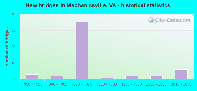
- New bridges - historical statistics
- 31950-1959
- 21960-1969
- 351970-1979
- 11980-1989
- 21990-1999
- 22000-2009
- 62010-2019


- Bridge Condition - Deck
- 7.7%Very good
- 15.4%Good
- 65.4%Satisfactory
- 11.5%Fair

- Bridge Condition - Superstructure
- 15.4%Very good
- 26.9%Good
- 46.2%Satisfactory
- 11.5%Fair

- Bridge Condition - Substructure
- 3.8%Very good
- 19.2%Good
- 57.7%Satisfactory
- 19.2%Fair

- Bridge Condition - Channel
- 3.7%Very good
- 22.2%Good
- 51.9%Satisfactory
- 18.5%Fair
- 3.7%Poor

- Bridge Condition - Culverts
- 7.7%Very good
- 46.2%Satisfactory
- 46.2%Fair
Find on map >> Show street view
Structure Number: 941, Location: 0.76 mi 360 & 0.16 1129 (Lat: 37.598497, Lng: -77.357808), Route carried "on" structure: State highway 156, Year Built: 1978, Status: Open, Structure Length: 5.75m (18.86ft), Average Daily Traffic: 11,540 (year 2020), Truck Traffic: 1%, Average Future Daily Traffic: 16,156 (year 2040), Design Load: HS 20+Mod, Features Intersected: BEAVERDAM CREEK, Facility Carried by Structure: COLD HARBOR ROAD
Minimum Vertical Clearance: 30+ m (98+ ft), Kilometerpoint: 96.580, Lanes on structure: 2, Owner: State Highway Agency, Approaching Roadway Width: 13.1m (43.0ft), Skew: 2 degrees, Material/Design: Steel continuous, Design/Construction: Stringer/Multi-beam, Number Of Spans In Main Unit: 3, Length of Maximum Span: 21.9m (71.9ft), Curb-To-Curb Width: 12.8m (42.0ft), Out-to-Out Width: 14.0m (45.9ft)
Condition: Deck: Satisfactory, Superstructure: Satisfactory, Substructure: Satisfactory, Channel: Satisfactory, Operating Rating: 48.4 metric tons, Method Used To Determine Operating Rating: Load and Resistance Factor (LRFR), Inventory Rating: 37.4 metric tons, Method Used To Determine Inventory Rating: Load and Resistance Factor (LRFR), Structural Evaluation: Equal to present minimum criteria, Deck Geometry: Somewhat better than minimum adequacy, Waterway Adequacy: Equal to present desirable criteria, Approach Roadway Alignment: Equal to present desirable criteria, Designated Inspection Frequency: Every 24 months, Inspection Date: June 2020, Deck Structure Type: Concrete Cast-file-Place, Wearing Surface/Protective System: Deck Protection: Epoxy Coated Reinforcing
Find on map >> Show street view
Structure Number: 9411, Location: 0.73 TO 718 & 0.94 TO 615 (Lat: 37.586722, Lng: -77.302117), Route carried "on" structure: State highway 156, Year Built: 1956, Status: Open, Structure Length: 0.64m (2.10ft), Average Daily Traffic: 3,663 (year 2020), Truck Traffic: 2%, Average Future Daily Traffic: 4,086 (year 2040), Design Load: HS 20, Features Intersected: POWHITE CREEK, Facility Carried by Structure: COLD HARBOR ROAD
Minimum Vertical Clearance: 30+ m (98+ ft), Kilometerpoint: 90.807, Lanes on structure: 2, Owner: State Highway Agency, Approaching Roadway Width: 9.1m (29.9ft), Material/Design: Concrete, Design/Construction: Culvert, Number Of Spans In Main Unit: 2, Length of Maximum Span: 3.0m (9.8ft)
Condition: Channel: Fair, Culverts: Fair, Operating Rating: 71.9 metric tons, Method Used To Determine Operating Rating: Load and Resistance Factor (LRFR), Inventory Rating: 55.4 metric tons, Method Used To Determine Inventory Rating: Load and Resistance Factor (LRFR), Structural Evaluation: Somewhat better than minimum adequacy, Waterway Adequacy: Better than present minimum criteria, Approach Roadway Alignment: Equal to present desirable criteria, Designated Inspection Frequency: Every 24 months, Inspection Date: Febuary 2021
Find on map >> Show street view
Structure Number: 9414, Location: 0.2 TO 1437 & 0.2 TO 1129 (Lat: 37.598600, Lng: -77.353681), Route carried "on" structure: State highway 156, Year Built: 1978, Status: Open, Structure Length: 17.38m (57.02ft), Average Daily Traffic: 11,540 (year 2020), Truck Traffic: 3%, Average Future Daily Traffic: 16,156 (year 2040), Design Load: HS 20+Mod, Features Intersected: RTE I 295, Facility Carried by Structure: COLD HARBOR ROAD
Minimum Vertical Clearance: 30+ m (98+ ft), Kilometerpoint: 96.057, Lanes on structure: 2, Lanes under structure: 8, Owner: State Highway Agency, Approaching Roadway Width: 13.1m (43.0ft), Skew: 3 degrees, Material/Design: Steel continuous, Design/Construction: Frame, Number Of Spans In Main Unit: 7, Length of Maximum Span: 41.5m (136.2ft), Curb-To-Curb Width: 12.8m (42.0ft), Out-to-Out Width: 14.0m (45.9ft)
Condition: Deck: Satisfactory, Superstructure: Satisfactory, Substructure: Satisfactory, Operating Rating: 54.4 metric tons, Method Used To Determine Operating Rating: Load and Resistance Factor (LRFR), Inventory Rating: 41.7 metric tons, Method Used To Determine Inventory Rating: Load and Resistance Factor (LRFR), Structural Evaluation: Equal to present minimum criteria, Deck Geometry: Somewhat better than minimum adequacy, Underclear: Better than present minimum criteria, Approach Roadway Alignment: Equal to present desirable criteria, Designated Inspection Frequency: Every 24 months, Inspection Date: September 2021, Deck Structure Type: Concrete Cast-file-Place, Wearing Surface/Protective System: Deck Protection: Epoxy Coated Reinforcing
Find on map >> Show street view
Structure Number: 9418, Location: .07 TO 295 & .25 TO 360 (Lat: 37.610169, Lng: -77.363403), Route carried "on" structure: Ramp Interstate 295, Year Built: 1978, Status: Open, Structure Length: 0.76m (2.49ft), Average Daily Traffic: 4,269 (year 2020), Average Future Daily Traffic: 5,977 (year 2040), Design Load: H 20, Features Intersected: RAMP C O BRANCH
Minimum Vertical Clearance: 30+ m (98+ ft), Kilometerpoint: 0.000, Lanes on structure: 1, Base Highway Network: Yes, Owner: State Highway Agency, Approaching Roadway Width: 9.1m (29.9ft), Skew: 3 degrees, Material/Design: Concrete, Design/Construction: Culvert, Number Of Spans In Main Unit: 2, Length of Maximum Span: 2.4m (7.9ft)
Condition: Channel: Poor, Culverts: Fair, Operating Rating: 54.4 metric tons, Method Used To Determine Operating Rating: Field evaluation and documented engineering judgment, Inventory Rating: 32.7 metric tons, Method Used To Determine Inventory Rating: Field evaluation and documented engineering judgment, Structural Evaluation: Somewhat better than minimum adequacy, Waterway Adequacy: Equal to present desirable criteria, Approach Roadway Alignment: Equal to present desirable criteria, Designated Inspection Frequency: Every 24 months, Inspection Date: November 2021
Find on map >> Show street view
Structure Number: 9419, Location: .55 FR 360 & 2.04 TO 615 (Lat: 37.601067, Lng: -77.355806), Route carried "on" structure: Interstate 295, Year Built: 1978, Status: Open, Structure Length: 0.79m (2.59ft), Average Daily Traffic: 73,440 (year 2020), Truck Traffic: 10%, Average Future Daily Traffic: 102,816 (year 2040), Design Load: HS 20+Mod, Features Intersected: BRANDY BRANCH
Minimum Vertical Clearance: 30+ m (98+ ft), Kilometerpoint: 26.050, Lanes on structure: 8, Base Highway Network: Yes, Owner: State Highway Agency, Approaching Roadway Width: 40.2m (131.9ft), Skew: 21 degrees, Material/Design: Concrete, Design/Construction: Culvert, Number Of Spans In Main Unit: 4, Length of Maximum Span: 1.8m (5.9ft)
Condition: Channel: Satisfactory, Culverts: Satisfactory, Operating Rating: 89.8 metric tons, Method Used To Determine Operating Rating: Field evaluation and documented engineering judgment, Inventory Rating: 89.8 metric tons, Method Used To Determine Inventory Rating: Field evaluation and documented engineering judgment, Structural Evaluation: Equal to present minimum criteria, Waterway Adequacy: Equal to present desirable criteria, Approach Roadway Alignment: Equal to present desirable criteria, Designated Inspection Frequency: Every 24 months, Inspection Date: September 2021
Find on map >> Show street view
Structure Number: 9422, Location: 2.6 TO 360 & 2.34 HENRICO (Lat: 37.581322, Lng: -77.329325), Route carried "on" structure: Interstate 295, Year Built: 1979, Status: Open, Structure Length: 6.53m (21.42ft), Average Daily Traffic: 37,239 (year 2020), Truck Traffic: 11%, Average Future Daily Traffic: 52,135 (year 2040), Design Load: HS 20+Mod, Features Intersected: RTE 615 (CREIGHTON RD)
Minimum Vertical Clearance: 30+ m (98+ ft), Kilometerpoint: 29.799, Lanes on structure: 5, Lanes under structure: 6, Base Highway Network: Yes, Owner: State Highway Agency, Approaching Roadway Width: 25.0m (82.0ft), Skew: 1 degrees, Material/Design: Steel continuous, Design/Construction: Stringer/Multi-beam, Number Of Spans In Main Unit: 2, Length of Maximum Span: 32.0m (105.0ft), Curb-To-Curb Width: 24.9m (81.7ft), Out-to-Out Width: 26.2m (86.0ft)
Condition: Deck: Good, Superstructure: Good, Substructure: Satisfactory, Operating Rating: 71.7 metric tons, Method Used To Determine Operating Rating: Load and Resistance Factor (LRFR), Inventory Rating: 55.3 metric tons, Method Used To Determine Inventory Rating: Load and Resistance Factor (LRFR), Structural Evaluation: Equal to present minimum criteria, Deck Geometry: Better than present minimum criteria, Underclear: Equal to present minimum criteria, Approach Roadway Alignment: Equal to present desirable criteria, Designated Inspection Frequency: Every 24 months, Inspection Date: August 2021, Deck Structure Type: Concrete Cast-file-Place, Wearing Surface/Protective System: Deck Protection: Epoxy Coated Reinforcing
Find on map >> Show street view
Structure Number: 9424, Location: 2.6 TO 360 & 2.34 HENRICO (Lat: 37.580856, Lng: -77.329831), Route carried "on" structure: Interstate 295, Year Built: 1979, Status: Open, Structure Length: 6.53m (21.42ft), Average Daily Traffic: 34,612 (year 2020), Truck Traffic: 11%, Average Future Daily Traffic: 48,457 (year 2040), Design Load: HS 20+Mod, Features Intersected: RTE 615 (CREIGHTON RD)
Minimum Vertical Clearance: 30+ m (98+ ft), Kilometerpoint: 29.799, Lanes on structure: 5, Lanes under structure: 6, Base Highway Network: Yes, Owner: State Highway Agency, Approaching Roadway Width: 25.0m (82.0ft), Skew: 1 degrees, Material/Design: Steel continuous, Design/Construction: Stringer/Multi-beam, Number Of Spans In Main Unit: 2, Length of Maximum Span: 32.0m (105.0ft), Curb-To-Curb Width: 24.9m (81.7ft), Out-to-Out Width: 26.2m (86.0ft)
Condition: Deck: Satisfactory, Superstructure: Good, Substructure: Satisfactory, Operating Rating: 71.7 metric tons, Method Used To Determine Operating Rating: Load and Resistance Factor (LRFR), Inventory Rating: 55.3 metric tons, Method Used To Determine Inventory Rating: Load and Resistance Factor (LRFR), Structural Evaluation: Equal to present minimum criteria, Deck Geometry: Better than present minimum criteria, Underclear: Equal to present minimum criteria, Approach Roadway Alignment: Equal to present desirable criteria, Designated Inspection Frequency: Every 24 months, Inspection Date: August 2021, Deck Structure Type: Concrete Cast-file-Place, Wearing Surface/Protective System: Deck Protection: Epoxy Coated Reinforcing
Find on map >> Show street view
Structure Number: 9426, Location: 0.20 FR 360 WBL (Lat: 37.608719, Lng: -77.362364), Route carried "on" structure: Ramp Interstate 295, Year Built: 1979, Status: Open, Structure Length: 4.91m (16.11ft), Average Daily Traffic: 2,949 (year 2020), Average Future Daily Traffic: 3,244 (year 2040), Design Load: HS 20+Mod, Features Intersected: BEAVERDAM CREEK
Minimum Vertical Clearance: 30+ m (98+ ft), Kilometerpoint: 0.000, Lanes on structure: 1, Base Highway Network: Yes, Owner: State Highway Agency, Approaching Roadway Width: 9.1m (29.9ft), Skew: 1 degrees, Material/Design: Steel continuous, Design/Construction: Stringer/Multi-beam, Number Of Spans In Main Unit: 3, Length of Maximum Span: 21.0m (68.9ft), Curb-To-Curb Width: 9.1m (29.9ft), Out-to-Out Width: 10.4m (34.1ft)
Condition: Deck: Satisfactory, Superstructure: Satisfactory, Substructure: Satisfactory, Channel: Satisfactory, Operating Rating: 79.8 metric tons, Method Used To Determine Operating Rating: Load and Resistance Factor (LRFR), Inventory Rating: 61.7 metric tons, Method Used To Determine Inventory Rating: Load and Resistance Factor (LRFR), Structural Evaluation: Equal to present minimum criteria, Deck Geometry: Superior to present desirable criteria, Waterway Adequacy: Superior to present desirable criteria, Approach Roadway Alignment: Equal to present desirable criteria, Designated Inspection Frequency: Every 24 months, Inspection Date: August 2021, Deck Structure Type: Concrete Cast-file-Place, Wearing Surface/Protective System: Deck Protection: Epoxy Coated Reinforcing
Find on map >> Show street view
Structure Number: 9427, Location: 0.25 FR 360 EBL (Lat: 37.604692, Lng: -77.360856), Route carried "on" structure: Ramp Interstate 295, Year Built: 1979, Status: Open, Structure Length: 7.90m (25.92ft), Average Daily Traffic: 2,007 (year 2020), Average Future Daily Traffic: 2,810 (year 2040), Design Load: HS 20+Mod, Features Intersected: BEAVERDAM CREEK
Minimum Vertical Clearance: 30+ m (98+ ft), Kilometerpoint: 0.000, Lanes on structure: 1, Base Highway Network: Yes, Owner: State Highway Agency, Approaching Roadway Width: 8.5m (27.9ft), Skew: 5 degrees, Material/Design: Steel, Design/Construction: Stringer/Multi-beam, Number Of Spans In Main Unit: 3, Length of Maximum Span: 26.5m (86.9ft), Curb-To-Curb Width: 8.5m (27.9ft), Out-to-Out Width: 9.8m (32.2ft)
Condition: Deck: Satisfactory, Superstructure: Satisfactory, Substructure: Fair, Channel: Very good, Operating Rating: 70.4 metric tons, Method Used To Determine Operating Rating: Load and Resistance Factor (LRFR), Inventory Rating: 54.3 metric tons, Method Used To Determine Inventory Rating: Load and Resistance Factor (LRFR), Structural Evaluation: Somewhat better than minimum adequacy, Deck Geometry: Superior to present desirable criteria, Waterway Adequacy: Superior to present desirable criteria, Approach Roadway Alignment: Equal to present desirable criteria, Designated Inspection Frequency: Every 24 months, Inspection Date: August 2021, Deck Structure Type: Concrete Cast-file-Place, Wearing Surface/Protective System: Deck Protection: Epoxy Coated Reinforcing
Find on map >> Show street view
Structure Number: 9428, Location: 0.15 FR I-295 SBL (Lat: 37.605600, Lng: -77.360889), Route carried "on" structure: Ramp Interstate 295, Year Built: 1979, Status: Open, Structure Length: 5.03m (16.50ft), Average Daily Traffic: 7,738 (year 2020), Average Future Daily Traffic: 10,078 (year 2040), Design Load: HS 20+Mod, Features Intersected: BEAVERDAM CREEK
Minimum Vertical Clearance: 30+ m (98+ ft), Kilometerpoint: 0.000, Lanes on structure: 1, Base Highway Network: Yes, Owner: State Highway Agency, Approaching Roadway Width: 9.1m (29.9ft), Skew: 1 degrees, Material/Design: Steel continuous, Design/Construction: Stringer/Multi-beam, Number Of Spans In Main Unit: 3, Length of Maximum Span: 19.1m (62.7ft), Curb-To-Curb Width: 9.1m (29.9ft), Out-to-Out Width: 10.4m (34.1ft)
Condition: Deck: Satisfactory, Superstructure: Satisfactory, Substructure: Satisfactory, Channel: Satisfactory, Operating Rating: 95.3 metric tons, Method Used To Determine Operating Rating: Load and Resistance Factor (LRFR), Inventory Rating: 73.5 metric tons, Method Used To Determine Inventory Rating: Load and Resistance Factor (LRFR), Structural Evaluation: Equal to present minimum criteria, Deck Geometry: Superior to present desirable criteria, Waterway Adequacy: Superior to present desirable criteria, Approach Roadway Alignment: Equal to present desirable criteria, Designated Inspection Frequency: Every 24 months, Inspection Date: August 2021, Deck Structure Type: Concrete Cast-file-Place, Wearing Surface/Protective System: Deck Protection: Epoxy Coated Reinforcing
Find on map >> Show street view
Structure Number: 9429, Location: 0.25360 WBL& 0.25295 WBL (Lat: 37.610611, Lng: -77.360550), Route carried "on" structure: Ramp Interstate 295, Year Built: 1979, Status: Open, Structure Length: 4.11m (13.48ft), Average Daily Traffic: 7,566 (year 2020), Average Future Daily Traffic: 8,526 (year 2040), Design Load: HS 20+Mod, Features Intersected: BEAVERDAM CREEK
Minimum Vertical Clearance: 30+ m (98+ ft), Kilometerpoint: 0.000, Lanes on structure: 1, Base Highway Network: Yes, Owner: State Highway Agency, Approaching Roadway Width: 8.5m (27.9ft), Material/Design: Steel continuous, Design/Construction: Stringer/Multi-beam, Number Of Spans In Main Unit: 2, Length of Maximum Span: 19.9m (65.3ft), Curb-To-Curb Width: 8.5m (27.9ft), Out-to-Out Width: 9.8m (32.2ft)
Condition: Deck: Good, Superstructure: Satisfactory, Substructure: Satisfactory, Channel: Satisfactory, Operating Rating: 68.1 metric tons, Method Used To Determine Operating Rating: Load and Resistance Factor (LRFR), Inventory Rating: 43.9 metric tons, Method Used To Determine Inventory Rating: Load and Resistance Factor (LRFR), Structural Evaluation: Equal to present minimum criteria, Deck Geometry: Superior to present desirable criteria, Waterway Adequacy: Superior to present desirable criteria, Approach Roadway Alignment: Equal to present desirable criteria, Designated Inspection Frequency: Every 24 months, Inspection Date: August 2021, Deck Structure Type: Concrete Cast-file-Place, Wearing Surface/Protective System: Deck Protection: Epoxy Coated Reinforcing
Find on map >> Show street view
Structure Number: 943, Location: 0.1 fr 360 & 1.5 to 627 (Lat: 37.609281, Lng: -77.362233), Route carried "on" structure: Interstate 295, Year Built: 1979, Status: Open, Structure Length: 5.21m (17.09ft), Average Daily Traffic: 36,201 (year 2020), Truck Traffic: 11%, Average Future Daily Traffic: 50,681 (year 2040), Design Load: HS 20+Mod, Features Intersected: BEAVERDAM CREEK
Minimum Vertical Clearance: 30+ m (98+ ft), Kilometerpoint: 25.454, Lanes on structure: 4, Base Highway Network: Yes, Owner: State Highway Agency, Approaching Roadway Width: 22.3m (73.2ft), Skew: 2 degrees, Material/Design: Steel continuous, Design/Construction: Stringer/Multi-beam, Number Of Spans In Main Unit: 2, Length of Maximum Span: 25.2m (82.7ft), Curb-To-Curb Width: 21.3m (69.9ft), Out-to-Out Width: 22.6m (74.1ft)
Condition: Deck: Satisfactory, Superstructure: Fair, Substructure: Satisfactory, Channel: Satisfactory, Operating Rating: 68.0 metric tons, Method Used To Determine Operating Rating: Load and Resistance Factor (LRFR), Inventory Rating: 52.4 metric tons, Method Used To Determine Inventory Rating: Load and Resistance Factor (LRFR), Structural Evaluation: Somewhat better than minimum adequacy, Deck Geometry: Better than present minimum criteria, Waterway Adequacy: Superior to present desirable criteria, Approach Roadway Alignment: Equal to present desirable criteria, Length Of Structure Improvement: 5.49m (18.01ft), Designated Inspection Frequency: Every 24 months, Inspection Date: August 2021, Bridge Improvement Cost: $132,000, Roadway Improvement Cost: $27,000, Total Project Cost: $165,000, Deck Structure Type: Concrete Cast-file-Place, Wearing Surface/Protective System: Deck Protection: Epoxy Coated Reinforcing
Find on map >> Show street view
Structure Number: 9431, Location: 0.1 FR 360 & 1.5 TO 627 (Lat: 37.609803, Lng: -77.361689), Route carried "on" structure: Interstate 295, Year Built: 1979, Status: Open, Structure Length: 5.64m (18.50ft), Average Daily Traffic: 43,013 (year 2020), Truck Traffic: 11%, Average Future Daily Traffic: 60,218 (year 2040), Design Load: HS 20+Mod, Features Intersected: BEAVERDAM CREEK
Minimum Vertical Clearance: 30+ m (98+ ft), Kilometerpoint: 25.438, Lanes on structure: 4, Base Highway Network: Yes, Owner: State Highway Agency, Approaching Roadway Width: 22.3m (73.2ft), Skew: 1 degrees, Material/Design: Steel continuous, Design/Construction: Stringer/Multi-beam, Number Of Spans In Main Unit: 2, Length of Maximum Span: 27.4m (89.9ft), Curb-To-Curb Width: 21.3m (69.9ft), Out-to-Out Width: 22.6m (74.1ft)
Condition: Deck: Satisfactory, Superstructure: Fair, Substructure: Satisfactory, Channel: Good, Operating Rating: 59.0 metric tons, Method Used To Determine Operating Rating: Load and Resistance Factor (LRFR), Inventory Rating: 45.5 metric tons, Method Used To Determine Inventory Rating: Load and Resistance Factor (LRFR), Structural Evaluation: Somewhat better than minimum adequacy, Deck Geometry: Better than present minimum criteria, Waterway Adequacy: Superior to present desirable criteria, Approach Roadway Alignment: Equal to present desirable criteria, Length Of Structure Improvement: 5.64m (18.50ft), Designated Inspection Frequency: Every 12 months, Inspection Date: August 2021, Bridge Improvement Cost: $400,000, Roadway Improvement Cost: $20,000, Total Project Cost: $430,000, Deck Structure Type: Concrete Cast-file-Place, Wearing Surface/Protective System: Deck Protection: Epoxy Coated Reinforcing
Find on map >> Show street view
Structure Number: 9432, Location: 1.42 TO 627 & 2.45 TO 615 (Lat: 37.607789, Lng: -77.361311), Route carried "on" structure: Interstate 295, Year Built: 1979, Status: Open, Structure Length: 9.07m (29.76ft), Average Daily Traffic: 36,201 (year 2020), Truck Traffic: 12%, Average Future Daily Traffic: 50,681 (year 2040), Design Load: HS 20+Mod, Features Intersected: ROUTE 360
Minimum Vertical Clearance: 30+ m (98+ ft), Kilometerpoint: 25.631, Lanes on structure: 5, Lanes under structure: 6, Base Highway Network: Yes, Owner: State Highway Agency, Approaching Roadway Width: 25.3m (83.0ft), Skew: 1 degrees, Material/Design: Steel continuous, Design/Construction: Stringer/Multi-beam, Number Of Spans In Main Unit: 2, Number Of Approach Spans: 2, Length of Maximum Span: 27.8m (91.2ft), Curb-To-Curb Width: 25.0m (82.0ft), Out-to-Out Width: 26.2m (86.0ft)
Condition: Deck: Satisfactory, Superstructure: Satisfactory, Substructure: Satisfactory, Operating Rating: 67.1 metric tons, Method Used To Determine Operating Rating: Load and Resistance Factor (LRFR), Inventory Rating: 51.7 metric tons, Method Used To Determine Inventory Rating: Load and Resistance Factor (LRFR), Structural Evaluation: Equal to present minimum criteria, Deck Geometry: Better than present minimum criteria, Underclear: Equal to present minimum criteria, Approach Roadway Alignment: Equal to present desirable criteria, Designated Inspection Frequency: Every 24 months, Inspection Date: August 2021, Deck Structure Type: Concrete Cast-file-Place, Wearing Surface/Protective System: Deck Protection: Epoxy Coated Reinforcing
Find on map >> Show street view
Structure Number: 9434, Location: 1.54 TO 627 & 1.59 FR 615 (Lat: 37.607958, Lng: -77.360622), Route carried "on" structure: Interstate 295, Year Built: 1979, Status: Open, Structure Length: 8.00m (26.25ft), Average Daily Traffic: 43,013 (year 2020), Truck Traffic: 12%, Average Future Daily Traffic: 60,218 (year 2040), Design Load: HS 20+Mod, Features Intersected: RTE 360
Minimum Vertical Clearance: 30+ m (98+ ft), Kilometerpoint: 25.631, Lanes on structure: 5, Lanes under structure: 6, Base Highway Network: Yes, Owner: State Highway Agency, Approaching Roadway Width: 25.3m (83.0ft), Skew: 1 degrees, Material/Design: Steel continuous, Design/Construction: Stringer/Multi-beam, Number Of Spans In Main Unit: 2, Number Of Approach Spans: 2, Length of Maximum Span: 27.8m (91.2ft), Curb-To-Curb Width: 25.0m (82.0ft), Out-to-Out Width: 26.2m (86.0ft)
Condition: Deck: Satisfactory, Superstructure: Satisfactory, Substructure: Satisfactory, Operating Rating: 71.7 metric tons, Method Used To Determine Operating Rating: Load and Resistance Factor (LRFR), Inventory Rating: 55.3 metric tons, Method Used To Determine Inventory Rating: Load and Resistance Factor (LRFR), Structural Evaluation: Equal to present minimum criteria, Deck Geometry: Better than present minimum criteria, Underclear: Equal to present minimum criteria, Approach Roadway Alignment: Equal to present desirable criteria, Designated Inspection Frequency: Every 24 months, Inspection Date: August 2021, Deck Structure Type: Concrete Cast-file-Place, Wearing Surface/Protective System: Deck Protection: Epoxy Coated Reinforcing
Find on map >> Show street view
Structure Number: 9452, Location: .26 TO 643 & .08 TO 1260 (Lat: 37.680433, Lng: -77.380478), Route carried "on" structure: US 301, Year Built: 1978, Status: Open, Structure Length: 0.74m (2.43ft), Average Daily Traffic: 8,457 (year 2020), Truck Traffic: 2%, Average Future Daily Traffic: 11,840 (year 2040), Design Load: H 20, Features Intersected: CRUMP CREEK, Facility Carried by Structure: CHAMBERLAYNE ROAD
Minimum Vertical Clearance: 30+ m (98+ ft), Kilometerpoint: 139.285, Lanes on structure: 4, Owner: State Highway Agency, Approaching Roadway Width: 14.6m (47.9ft), Skew: 21 degrees, Material/Design: Concrete, Design/Construction: Culvert, Number Of Spans In Main Unit: 3, Length of Maximum Span: 2.0m (6.6ft)
Condition: Channel: Fair, Culverts: Fair, Operating Rating: 89.8 metric tons, Method Used To Determine Operating Rating: Load Factor (LF), Inventory Rating: 89.8 metric tons, Method Used To Determine Inventory Rating: Load Factor (LF), Structural Evaluation: Somewhat better than minimum adequacy, Waterway Adequacy: Equal to present desirable criteria, Approach Roadway Alignment: Equal to present desirable criteria, Designated Inspection Frequency: Every 24 months, Inspection Date: October 2020
Find on map >> Show street view
Structure Number: 9454, Location: .20 fr 1050 & .53 to 643 (Lat: 37.669206, Lng: -77.382158), Route carried "on" structure: US 301, Year Built: 1978, Status: Open, Structure Length: 1.07m (3.51ft), Average Daily Traffic: 14,245 (year 2020), Truck Traffic: 2%, Average Future Daily Traffic: 15,670 (year 2040), Design Load: HS 20+Mod, Features Intersected: TOTOPOTOMOY CREEK, Facility Carried by Structure: CHAMBERLAYNE ROAD
Minimum Vertical Clearance: 30+ m (98+ ft), Kilometerpoint: 138.020, Lanes on structure: 4, Owner: State Highway Agency, Approaching Roadway Width: 14.6m (47.9ft), Skew: 22 degrees, Material/Design: Concrete, Design/Construction: Culvert, Number Of Spans In Main Unit: 3, Length of Maximum Span: 3.4m (11.2ft)
Condition: Channel: Satisfactory, Culverts: Satisfactory, Operating Rating: 54.4 metric tons, Method Used To Determine Operating Rating: Field evaluation and documented engineering judgment, Inventory Rating: 32.7 metric tons, Method Used To Determine Inventory Rating: Field evaluation and documented engineering judgment, Structural Evaluation: Equal to present minimum criteria, Waterway Adequacy: Equal to present desirable criteria, Approach Roadway Alignment: Equal to present desirable criteria, Designated Inspection Frequency: Every 24 months, Inspection Date: October 2020
Find on map >> Show street view
Structure Number: 9455, Location: .53Fr Henrico& .62To 637 (Lat: 37.644642, Lng: -77.414339), Route carried "on" structure: US 301, Year Built: 1978, Status: Open, Structure Length: 10.46m (34.32ft), Average Daily Traffic: 9,642 (year 2020), Truck Traffic: 2%, Average Future Daily Traffic: 13,500 (year 2040), Design Load: HS 20+Mod, Features Intersected: INTERSTATE 295, Facility Carried by Structure: CHAMBERLAYNE SBL
Minimum Vertical Clearance: 30+ m (98+ ft), Kilometerpoint: 133.878, Lanes on structure: 3, Lanes under structure: 10, Base Highway Network: Yes, Owner: State Highway Agency, Approaching Roadway Width: 18.0m (59.1ft), Material/Design: Steel continuous, Design/Construction: Stringer/Multi-beam, Number Of Spans In Main Unit: 2, Length of Maximum Span: 53.9m (176.8ft), Curb-To-Curb Width: 15.2m (49.9ft), Out-to-Out Width: 16.5m (54.1ft)
Condition: Deck: Satisfactory, Superstructure: Good, Substructure: Fair, Operating Rating: 72.6 metric tons, Method Used To Determine Operating Rating: Load and Resistance Factor (LRFR), Inventory Rating: 56.2 metric tons, Method Used To Determine Inventory Rating: Load and Resistance Factor (LRFR), Structural Evaluation: Somewhat better than minimum adequacy, Deck Geometry: Equal to present minimum criteria, Underclear: Somewhat better than minimum adequacy, Approach Roadway Alignment: Equal to present desirable criteria, Designated Inspection Frequency: Every 24 months, Inspection Date: January 2021, Deck Structure Type: Concrete Cast-file-Place
Find on map >> Show street view
Structure Number: 9457, Location: .53Fr Henrico & .62 To637 (Lat: 37.644517, Lng: -77.414214), Route carried "on" structure: US 301, Year Built: 1978, Status: Open, Structure Length: 10.46m (34.32ft), Average Daily Traffic: 9,642 (year 2020), Truck Traffic: 2%, Average Future Daily Traffic: 13,500 (year 2040), Design Load: HS 20+Mod, Features Intersected: INTERSTATE 295, Facility Carried by Structure: CHAMBERLAYNE NBL
Minimum Vertical Clearance: 30+ m (98+ ft), Kilometerpoint: 133.878, Lanes on structure: 3, Lanes under structure: 10, Owner: State Highway Agency, Approaching Roadway Width: 18.0m (59.1ft), Material/Design: Steel continuous, Design/Construction: Stringer/Multi-beam, Number Of Spans In Main Unit: 2, Length of Maximum Span: 53.9m (176.8ft), Curb-To-Curb Width: 15.2m (49.9ft), Out-to-Out Width: 16.5m (54.1ft)
Condition: Deck: Satisfactory, Superstructure: Good, Substructure: Fair, Operating Rating: 68.9 metric tons, Method Used To Determine Operating Rating: Load and Resistance Factor (LRFR), Inventory Rating: 53.5 metric tons, Method Used To Determine Inventory Rating: Load and Resistance Factor (LRFR), Structural Evaluation: Somewhat better than minimum adequacy, Deck Geometry: Equal to present minimum criteria, Underclear: Somewhat better than minimum adequacy, Approach Roadway Alignment: Equal to present desirable criteria, Designated Inspection Frequency: Every 24 months, Inspection Date: January 2021, Deck Structure Type: Concrete Cast-file-Place
Find on map >> Show street view
Structure Number: 9459, Location: 0.66 TO 638 & 0.23 TO 640 (Lat: 37.656250, Lng: -77.389000), Route carried "on" structure: US 301, Year Built: 1956, Status: Open, Structure Length: 0.70m (2.30ft), Average Daily Traffic: 19,285 (year 2020), Truck Traffic: 2%, Average Future Daily Traffic: 26,999 (year 2040), Design Load: H 20, Features Intersected: OPOSSUM CREEK, Facility Carried by Structure: CHAMBERLAYNE ROAD
Minimum Vertical Clearance: 30+ m (98+ ft), Kilometerpoint: 136.427, Lanes on structure: 4, Owner: State Highway Agency, Approaching Roadway Width: 15.8m (51.8ft), Skew: 20 degrees, Material/Design: Concrete, Design/Construction: Culvert, Number Of Spans In Main Unit: 3, Length of Maximum Span: 1.8m (5.9ft)
Condition: Channel: Satisfactory, Culverts: Satisfactory, Operating Rating: 44.5 metric tons, Method Used To Determine Operating Rating: Field evaluation and documented engineering judgment, Inventory Rating: 32.7 metric tons, Method Used To Determine Inventory Rating: Field evaluation and documented engineering judgment, Structural Evaluation: Equal to present minimum criteria, Waterway Adequacy: Equal to present minimum criteria, Approach Roadway Alignment: Equal to present desirable criteria, Designated Inspection Frequency: Every 24 months, Inspection Date: October 2020
Find on map >> Show street view
Structure Number: 9464, Location: .60 fm Rt 156 .20 to 295 (Lat: 37.607103, Lng: -77.362397), Route carried "on" structure: US 360, Year Built: 1977, Status: Open, Structure Length: 1.71m (5.61ft), Average Daily Traffic: 22,480 (year 2020), Truck Traffic: 2%, Average Future Daily Traffic: 26,237 (year 2040), Design Load: HS 20+Mod, Features Intersected: BEAVERDAM CREEK, Facility Carried by Structure: MECHANICSVILLE TPK
Minimum Vertical Clearance: 30+ m (98+ ft), Kilometerpoint: 237.585, Lanes on structure: 6, Base Highway Network: Yes, Owner: State Highway Agency, Approaching Roadway Width: 48.8m (160.1ft), Skew: 21 degrees, Material/Design: Concrete, Design/Construction: Culvert, Number Of Spans In Main Unit: 5, Length of Maximum Span: 3.2m (10.5ft)
Condition: Channel: Fair, Culverts: Fair, Operating Rating: 89.8 metric tons, Method Used To Determine Operating Rating: Field evaluation and documented engineering judgment, Inventory Rating: 89.8 metric tons, Method Used To Determine Inventory Rating: Field evaluation and documented engineering judgment, Structural Evaluation: Somewhat better than minimum adequacy, Waterway Adequacy: Equal to present desirable criteria, Approach Roadway Alignment: Equal to present desirable criteria, Designated Inspection Frequency: Every 24 months, Inspection Date: November 2021
Find on map >> Show street view
Structure Number: 9477, Location: 1.69 TO 640 & 1.10 TO 643 (Lat: 37.658156, Lng: -77.353461), Route carried "on" structure: County highway 606, Year Built: 1963, Status: Open, Structure Length: 1.01m (3.31ft), Average Daily Traffic: 3,588 (year 2020), Truck Traffic: 2%, Average Future Daily Traffic: 3,947 (year 2040), Design Load: HS 20, Features Intersected: TOTOPOTOMOY CREEK, Facility Carried by Structure: STUDLEY ROAD
Minimum Vertical Clearance: 30+ m (98+ ft), Kilometerpoint: 4.161, Lanes on structure: 2, Owner: State Highway Agency, Approaching Roadway Width: 8.5m (27.9ft), Skew: 2 degrees, Material/Design: Concrete, Design/Construction: Culvert, Number Of Spans In Main Unit: 3, Length of Maximum Span: 3.2m (10.5ft)
Condition: Channel: Satisfactory, Culverts: Satisfactory, Operating Rating: 54.4 metric tons, Method Used To Determine Operating Rating: Field evaluation and documented engineering judgment, Inventory Rating: 32.7 metric tons, Method Used To Determine Inventory Rating: Field evaluation and documented engineering judgment, Structural Evaluation: Equal to present minimum criteria, Waterway Adequacy: Better than present minimum criteria, Approach Roadway Alignment: Equal to present desirable criteria, Designated Inspection Frequency: Every 24 months, Inspection Date: Febuary 2021
Find on map >> Show street view
Structure Number: 9503, Location: 0.25 FR 640 & 0.95 TO 642 (Lat: 37.629172, Lng: -77.372978), Route carried "on" structure: County highway 627, Year Built: 1979, Status: Open, Structure Length: 16.37m (53.71ft), Average Daily Traffic: 19,511 (year 2020), Truck Traffic: 1%, Average Future Daily Traffic: 27,315 (year 2040), Design Load: HS 20+Mod, Features Intersected: I-295, Facility Carried by Structure: POLE GREEN ROAD
Minimum Vertical Clearance: 30+ m (98+ ft), Kilometerpoint: 3.765, Lanes on structure: 6, Lanes under structure: 10, Owner: State Highway Agency, Approaching Roadway Width: 33.5m (109.9ft), Skew: 23 degrees, Material/Design: Steel continuous, Design/Construction: Stringer/Multi-beam, Number Of Spans In Main Unit: 3, Number Of Approach Spans: 2, Length of Maximum Span: 48.5m (159.1ft), Curb-To-Curb Width: 28.0m (91.9ft), Out-to-Out Width: 34.1m (111.9ft)
Condition: Deck: Fair, Superstructure: Satisfactory, Substructure: Fair, Operating Rating: 71.7 metric tons, Method Used To Determine Operating Rating: Load and Resistance Factor (LRFR), Inventory Rating: 55.3 metric tons, Method Used To Determine Inventory Rating: Load and Resistance Factor (LRFR), Structural Evaluation: Somewhat better than minimum adequacy, Deck Geometry: Superior to present desirable criteria, Underclear: Equal to present minimum criteria, Approach Roadway Alignment: Equal to present desirable criteria, Designated Inspection Frequency: Every 24 months, Inspection Date: July 2021, Deck Structure Type: Concrete Cast-file-Place, Wearing Surface/Protective System: Deck Protection: Epoxy Coated Reinforcing
Find on map >> Show street view
Structure Number: 9505, Location: 0.00HENRIC CO0.00HANOVE C (Lat: 37.611769, Lng: -77.406417), Route carried "on" structure: County highway 627, Year Built: 1955, Status: Open, Structure Length: 3.04m (9.97ft), Average Daily Traffic: 8,040 (year 2020), Truck Traffic: 2%, Average Future Daily Traffic: 8,956 (year 2040), Design Load: H 20, Features Intersected: CHICKAHOMINY RIVER, Facility Carried by Structure: MEADOWBRIDGE ROAD
Minimum Vertical Clearance: 30+ m (98+ ft), Kilometerpoint: 0.016, Lanes on structure: 2, Owner: State Highway Agency, Approaching Roadway Width: 7.9m (25.9ft), Material/Design: Concrete, Design/Construction: Tee Beam, Number Of Spans In Main Unit: 3, Length of Maximum Span: 9.4m (30.8ft), Curb or Sidewalk Widths: Left: 0.5m (1.6ft), Right: 0.5m (1.6ft), Curb-To-Curb Width: 7.9m (25.9ft), Out-to-Out Width: 8.4m (27.6ft)
Condition: Deck: Fair, Superstructure: Fair, Substructure: Satisfactory, Channel: Good, Operating Rating: 50.8 metric tons, Method Used To Determine Operating Rating: Load and Resistance Factor (LRFR), Inventory Rating: 39.0 metric tons, Method Used To Determine Inventory Rating: Load and Resistance Factor (LRFR), Structural Evaluation: Somewhat better than minimum adequacy, Deck Geometry: High priority of replacement, Waterway Adequacy: Equal to present minimum criteria, Approach Roadway Alignment: Equal to present desirable criteria, Length Of Structure Improvement: 3.05m (10.01ft), Designated Inspection Frequency: Every 24 months, Underwater Inspection Frequency: Every 60 months, Inspection Date: September 2020, Underwater Inspection Date: July 2021, Bridge Improvement Cost: $220,000, Roadway Improvement Cost: $85,000, Total Project Cost: $372,000, Deck Structure Type: Concrete Cast-file-Place, Wearing Surface/Protective System: Wearing Surface: Bituminous
Find on map >> Show street view
Structure Number: 9512, Location: 0.10 TO 1401 & .3 TO 1413 (Lat: 37.633328, Lng: -77.387528), Route carried "on" structure: County highway 638, Year Built: 1978, Status: Open, Structure Length: 9.22m (30.25ft), Average Daily Traffic: 7,898 (year 2020), Truck Traffic: 1%, Average Future Daily Traffic: 11,057 (year 2040), Design Load: HS 20+Mod, Features Intersected: RTE I 295, Facility Carried by Structure: ATLEE ROAD
Minimum Vertical Clearance: 30+ m (98+ ft), Kilometerpoint: 3.878, Lanes on structure: 2, Lanes under structure: 8, Owner: State Highway Agency, Approaching Roadway Width: 10.7m (35.1ft), Skew: 1 degrees, Material/Design: Steel continuous, Design/Construction: Stringer/Multi-beam, Number Of Spans In Main Unit: 2, Length of Maximum Span: 45.5m (149.3ft), Curb-To-Curb Width: 10.4m (34.1ft), Out-to-Out Width: 11.6m (38.1ft)
Condition: Deck: Satisfactory, Superstructure: Satisfactory, Substructure: Fair, Operating Rating: 76.2 metric tons, Method Used To Determine Operating Rating: Load and Resistance Factor (LRFR), Inventory Rating: 58.1 metric tons, Method Used To Determine Inventory Rating: Load and Resistance Factor (LRFR), Structural Evaluation: Somewhat better than minimum adequacy, Deck Geometry: Meets minimum limits, Underclear: Equal to present minimum criteria, Approach Roadway Alignment: Equal to present desirable criteria, Designated Inspection Frequency: Every 24 months, Inspection Date: July 2021, Deck Structure Type: Concrete Cast-file-Place
Find on map >> Show street view
Structure Number: 9514, Location: 0.3 TO 627 & .9 TO 710 (Lat: 37.631431, Lng: -77.378911), Route carried "on" structure: County highway 640, Year Built: 1979, Status: Open, Structure Length: 13.93m (45.70ft), Average Daily Traffic: 7,069 (year 2020), Truck Traffic: 1%, Average Future Daily Traffic: 8,620 (year 2040), Design Load: HS 20+Mod, Features Intersected: RTE I 295, Facility Carried by Structure: SHADY GROVE ROAD
Minimum Vertical Clearance: 30+ m (98+ ft), Kilometerpoint: 4.383, Lanes on structure: 4, Lanes under structure: 9, Owner: State Highway Agency, Approaching Roadway Width: 21.3m (69.9ft), Skew: 24 degrees, Material/Design: Steel continuous, Design/Construction: Frame, Number Of Spans In Main Unit: 5, Length of Maximum Span: 44.3m (145.3ft), Curb-To-Curb Width: 20.7m (67.9ft), Out-to-Out Width: 26.8m (87.9ft)
Condition: Deck: Satisfactory, Superstructure: Satisfactory, Substructure: Satisfactory, Operating Rating: 67.1 metric tons, Method Used To Determine Operating Rating: Load and Resistance Factor (LRFR), Inventory Rating: 51.7 metric tons, Method Used To Determine Inventory Rating: Load and Resistance Factor (LRFR), Structural Evaluation: Equal to present minimum criteria, Deck Geometry: Superior to present desirable criteria, Underclear: Better than present minimum criteria, Approach Roadway Alignment: Equal to present desirable criteria, Designated Inspection Frequency: Every 24 months, Inspection Date: August 2021, Deck Structure Type: Concrete Cast-file-Place, Wearing Surface/Protective System: Deck Protection: Epoxy Coated Reinforcing
Find on map >> Show street view
Structure Number: 9518, Location: 0.30 TO 360 & 0.06 TO1126 (Lat: 37.611500, Lng: -77.359278), Route carried "on" structure: County highway 642, Year Built: 1977, Status: Open, Structure Length: 5.03m (16.50ft), Average Daily Traffic: 3,353 (year 2020), Truck Traffic: 1%, Average Future Daily Traffic: 3,430 (year 2040), Design Load: HS 20+Mod, Features Intersected: BEAVERDAM CREEK, Facility Carried by Structure: BELL CREEK ROAD
Minimum Vertical Clearance: 30+ m (98+ ft), Kilometerpoint: 1.963, Lanes on structure: 2, Owner: State Highway Agency, Approaching Roadway Width: 12.2m (40.0ft), Skew: 2 degrees, Material/Design: Steel, Design/Construction: Stringer/Multi-beam, Number Of Spans In Main Unit: 3, Length of Maximum Span: 15.5m (50.9ft), Curb-To-Curb Width: 11.1m (36.4ft), Out-to-Out Width: 12.3m (40.4ft)
Condition: Deck: Satisfactory, Superstructure: Satisfactory, Substructure: Satisfactory, Channel: Satisfactory, Operating Rating: 68.0 metric tons, Method Used To Determine Operating Rating: Load and Resistance Factor (LRFR), Inventory Rating: 52.6 metric tons, Method Used To Determine Inventory Rating: Load and Resistance Factor (LRFR), Structural Evaluation: Equal to present minimum criteria, Deck Geometry: Somewhat better than minimum adequacy, Waterway Adequacy: Better than present minimum criteria, Approach Roadway Alignment: Equal to present desirable criteria, Designated Inspection Frequency: Every 24 months, Inspection Date: June 2020, Deck Structure Type: Concrete Cast-file-Place
Find on map >> Show street view
Structure Number: 9519, Location: 1.0 TO 627 & 1.2 TO 606 (Lat: 37.652356, Lng: -77.330964), Route carried "on" structure: County highway 643, Year Built: 1988, Status: Open, Structure Length: 4.04m (13.25ft), Average Daily Traffic: 3,356 (year 2020), Truck Traffic: 3%, Average Future Daily Traffic: 4,446 (year 2040), Design Load: HS 20+Mod, Features Intersected: TOTOPOTOMOY CREEK, Facility Carried by Structure: RURAL POINT ROAD
Minimum Vertical Clearance: 30+ m (98+ ft), Kilometerpoint: 6.573, Lanes on structure: 2, Owner: State Highway Agency, Approaching Roadway Width: 10.1m (33.1ft), Material/Design: Steel, Design/Construction: Stringer/Multi-beam, Number Of Spans In Main Unit: 2, Length of Maximum Span: 19.8m (65.0ft), Curb or Sidewalk Widths: Left: 0.2m (0.7ft), Right: 0.2m (0.7ft), Curb-To-Curb Width: 9.9m (32.5ft), Out-to-Out Width: 10.9m (35.8ft)
Condition: Deck: Satisfactory, Superstructure: Good, Substructure: Satisfactory, Channel: Fair, Operating Rating: 70.8 metric tons, Method Used To Determine Operating Rating: Load and Resistance Factor (LRFR), Inventory Rating: 54.4 metric tons, Method Used To Determine Inventory Rating: Load and Resistance Factor (LRFR), Structural Evaluation: Equal to present minimum criteria, Deck Geometry: Meets minimum limits, Waterway Adequacy: Equal to present desirable criteria, Approach Roadway Alignment: Equal to present desirable criteria, Designated Inspection Frequency: Every 24 months, Underwater Inspection Frequency: Every 60 months, Inspection Date: May 2020, Underwater Inspection Date: July 2021, Deck Structure Type: Concrete Cast-file-Place, Wearing Surface/Protective System: Deck Protection: Epoxy Coated Reinforcing
Find on map >> Show street view
Structure Number: 952, Location: 1.25 TO 627 & .50 TO 360 (Lat: 37.619839, Lng: -77.339972), Route carried "on" structure: County highway 643, Year Built: 1973, Year Reconstructed: 2020, Status: Open, Structure Length: 1.56m (5.12ft), Average Daily Traffic: 9,558 (year 2020), Truck Traffic: 1%, Average Future Daily Traffic: 13,381 (year 2040), Design Load: H 20, Features Intersected: BEAVERDAM CREEK, Facility Carried by Structure: LEE DAVIS ROAD
Minimum Vertical Clearance: 30+ m (98+ ft), Kilometerpoint: 2.306, Lanes on structure: 2, Owner: State Highway Agency, Approaching Roadway Width: 10.7m (35.1ft), Material/Design: Steel, Design/Construction: Culvert, Number Of Spans In Main Unit: 3, Length of Maximum Span: 3.8m (12.5ft)
Condition: Channel: Good, Culverts: Very good, Operating Rating: 89.8 metric tons, Method Used To Determine Operating Rating: Field evaluation and documented engineering judgment, Inventory Rating: 89.8 metric tons, Method Used To Determine Inventory Rating: Field evaluation and documented engineering judgment, Structural Evaluation: Equal to present desirable criteria, Waterway Adequacy: Equal to present minimum criteria, Approach Roadway Alignment: Equal to present minimum criteria, Designated Inspection Frequency: Every 24 months, Inspection Date: December 2020
Find on map >> Show street view
Structure Number: 25481, Location: 1.18 fr 637 & .60 to 643 (Lat: 37.671364, Lng: -77.396950), Route carried "on" structure: County highway 652, Year Built: 1998, Status: Open, Structure Length: 0.73m (2.40ft), Average Daily Traffic: 1,920 (year 2020), Truck Traffic: 1%, Average Future Daily Traffic: 2,688 (year 2040), Design Load: H 20, Features Intersected: TOTOPOTOMY CREEK, Facility Carried by Structure: COOL SPRING ROAD
Minimum Vertical Clearance: 30+ m (98+ ft), Kilometerpoint: 1.786, Lanes on structure: 2, Owner: State Highway Agency, Approaching Roadway Width: 7.3m (24.0ft), Material/Design: Steel, Design/Construction: Culvert, Number Of Spans In Main Unit: 3, Length of Maximum Span: 1.8m (5.9ft)
Condition: Channel: Fair, Culverts: Fair, Operating Rating: 44.5 metric tons, Method Used To Determine Operating Rating: Field evaluation and documented engineering judgment, Inventory Rating: 32.7 metric tons, Method Used To Determine Inventory Rating: Field evaluation and documented engineering judgment, Structural Evaluation: Somewhat better than minimum adequacy, Waterway Adequacy: Equal to present minimum criteria, Approach Roadway Alignment: Equal to present desirable criteria, Designated Inspection Frequency: Every 24 months, Inspection Date: December 2020
Find on map >> Show street view
Structure Number: 26959, Location: 1.11 FR 627 & 1.50 TO 606 (Lat: 37.657964, Lng: -77.296119), Route carried "on" structure: County highway 615, Year Built: 2001, Status: Open, Structure Length: 1.62m (5.31ft), Average Daily Traffic: 1,210 (year 2020), Truck Traffic: 1%, Average Future Daily Traffic: 1,331 (year 2040), Design Load: HS 20+Mod, Features Intersected: TOTOPOTOMOY CREEK, Facility Carried by Structure: WILLIAMSVILLE ROAD
Minimum Vertical Clearance: 30+ m (98+ ft), Kilometerpoint: 11.488, Lanes on structure: 2, Owner: State Highway Agency, Approaching Roadway Width: 6.7m (22.0ft), Material/Design: Steel, Design/Construction: Stringer/Multi-beam, Number Of Spans In Main Unit: 1, Length of Maximum Span: 15.8m (51.8ft), Curb-To-Curb Width: 7.3m (24.0ft), Out-to-Out Width: 7.6m (24.9ft)
Condition: Deck: Fair, Superstructure: Very good, Substructure: Good, Channel: Satisfactory, Operating Rating: 67.1 metric tons, Method Used To Determine Operating Rating: Load and Resistance Factor (LRFR), Inventory Rating: 51.7 metric tons, Method Used To Determine Inventory Rating: Load and Resistance Factor (LRFR), Structural Evaluation: Better than present minimum criteria, Deck Geometry: Meets minimum limits, Waterway Adequacy: Equal to present minimum criteria, Approach Roadway Alignment: Better than present minimum criteria, Designated Inspection Frequency: Every 24 months, Inspection Date: August 2021, Deck Structure Type: Corrugated Steel, Wearing Surface/Protective System: Wearing Surface: Bituminous
Find on map >> Show street view
Structure Number: 28079, Location: .40 FR 156 & 0.20 TO 360 (Lat: 37.602964, Lng: -77.353286), Route carried "on" structure: County highway 642, Year Built: 1995, Status: Open, Structure Length: 1.33m (4.36ft), Average Daily Traffic: 11,569 (year 2020), Truck Traffic: 1%, Average Future Daily Traffic: 16,197 (year 2040), Design Load: HS 20+Mod, Features Intersected: BRANDY BRANCH, Facility Carried by Structure: BELL CREEK ROAD
Minimum Vertical Clearance: 30+ m (98+ ft), Kilometerpoint: 0.644, Lanes on structure: 4, Owner: State Highway Agency, Approaching Roadway Width: 17.1m (56.1ft), Skew: 21 degrees, Material/Design: Concrete, Design/Construction: Culvert, Number Of Spans In Main Unit: 4, Length of Maximum Span: 3.1m (10.2ft)
Condition: Channel: Satisfactory, Culverts: Satisfactory, Operating Rating: 89.8 metric tons, Method Used To Determine Operating Rating: Field evaluation and documented engineering judgment, Inventory Rating: 89.8 metric tons, Method Used To Determine Inventory Rating: Field evaluation and documented engineering judgment, Structural Evaluation: Equal to present minimum criteria, Waterway Adequacy: Equal to present desirable criteria, Approach Roadway Alignment: Equal to present desirable criteria, Designated Inspection Frequency: Every 24 months, Inspection Date: January 2021
Find on map >> Show street view
Structure Number: 28127, Location: 0.48 TO 654 & 0.42 TO 653 (Lat: 37.700600, Lng: -77.384914), Route carried "on" structure: US 301, Year Built: 2005, Status: Open, Structure Length: 2.59m (8.50ft), Average Daily Traffic: 6,872 (year 2020), Truck Traffic: 4%, Average Future Daily Traffic: 9,621 (year 2040), Design Load: HS 20+Mod, Features Intersected: KERSEY CREEK, Facility Carried by Structure: CHAMBERLAYNE ROAD
Minimum Vertical Clearance: 30+ m (98+ ft), Kilometerpoint: 141.587, Lanes on structure: 2, Owner: State Highway Agency, Approaching Roadway Width: 12.8m (42.0ft), Material/Design: Steel, Design/Construction: Stringer/Multi-beam, Number Of Spans In Main Unit: 1, Length of Maximum Span: 25.9m (85.0ft), Curb or Sidewalk Widths: Left: 0.2m (0.7ft), Right: 0.2m (0.7ft), Curb-To-Curb Width: 12.9m (42.3ft), Out-to-Out Width: 13.9m (45.6ft)
Condition: Deck: Good, Superstructure: Good, Substructure: Good, Channel: Good, Operating Rating: 85.3 metric tons, Method Used To Determine Operating Rating: Load and Resistance Factor (LRFR), Inventory Rating: 66.2 metric tons, Method Used To Determine Inventory Rating: Load and Resistance Factor (LRFR), Structural Evaluation: Better than present minimum criteria, Deck Geometry: Somewhat better than minimum adequacy, Waterway Adequacy: Equal to present minimum criteria, Approach Roadway Alignment: Equal to present desirable criteria, Designated Inspection Frequency: Every 24 months, Inspection Date: March 2021, Deck Structure Type: Concrete Cast-file-Place, Wearing Surface/Protective System: Deck Protection: Epoxy Coated Reinforcing
Find on map >> Show street view
Structure Number: 29315, Location: 2.59 Fr 643 & 0.21 To 325 (Lat: 37.706164, Lng: -77.363008), Route carried "on" structure: County highway 651, Year Built: 2014, Status: Open, Structure Length: 2.53m (8.30ft), Average Daily Traffic: 728 (year 2020), Truck Traffic: 3%, Average Future Daily Traffic: 801 (year 2040), Design Load: HL 93, Features Intersected: CRUMP CREEK, Facility Carried by Structure: GEORGETOWN ROAD
Minimum Vertical Clearance: 30+ m (98+ ft), Kilometerpoint: 4.168, Lanes on structure: 2, Owner: State Highway Agency, Approaching Roadway Width: 11.4m (37.4ft), Skew: 1 degrees, Material/Design: Prestressed concrete, Design/Construction: Stringer/Multi-beam, Number Of Spans In Main Unit: 1, Length of Maximum Span: 23.7m (77.8ft), Curb-To-Curb Width: 11.4m (37.4ft), Out-to-Out Width: 11.6m (38.1ft)
Condition: Deck: Satisfactory, Superstructure: Very good, Substructure: Good, Channel: Satisfactory, Operating Rating: 71.7 metric tons, Method Used To Determine Operating Rating: Load and Resistance Factor (LRFR), Inventory Rating: 55.3 metric tons, Method Used To Determine Inventory Rating: Load and Resistance Factor (LRFR), Structural Evaluation: Better than present minimum criteria, Deck Geometry: Better than present minimum criteria, Approach Roadway Alignment: Somewhat better than minimum adequacy, Length Of Structure Improvement: 2.44m (8.01ft), Designated Inspection Frequency: Every 24 months, Inspection Date: August 2020, Bridge Improvement Cost: $50,000, Roadway Improvement Cost: $50,000, Total Project Cost: $200,000 ( Estimate for 2014), Deck Structure Type: Concrete Precast Panels, Wearing Surface/Protective System: Wearing Surface: Integral Concrete, Deck Protection: Other
Find on map >> Show street view
Structure Number: 29616, Location: 0.10 FR 637 & 0.80 TO 301 (Lat: 37.658931, Lng: -77.407536), Route carried "on" structure: County highway 638, Year Built: 2016, Status: Open, Structure Length: 4.18m (13.71ft), Average Daily Traffic: 180 (year 2019), Average Future Daily Traffic: 272 (year 2040), Design Load: HL 93, Features Intersected: CSX RAILWAY, Facility Carried by Structure: ATLEE ROAD
Minimum Vertical Clearance: 30.45m (99.90ft), Kilometerpoint: 0.000, Lanes on structure: 3, Owner: State Highway Agency, Approaching Roadway Width: 14.5m (47.6ft), Skew: 4 degrees, Material/Design: Steel, Design/Construction: Stringer/Multi-beam, Number Of Spans In Main Unit: 1, Length of Maximum Span: 39.4m (129.3ft), Curb or Sidewalk Widths: Left: 0.0m, Right: 1.8m (5.9ft), Curb-To-Curb Width: 14.6m (47.9ft), Out-to-Out Width: 17.1m (56.1ft)
Condition: Deck: Very good, Superstructure: Very good, Substructure: Good, Operating Rating: 72.4 metric tons, Method Used To Determine Operating Rating: Load and Resistance Factor (LRFR), Inventory Rating: 55.9 metric tons, Method Used To Determine Inventory Rating: Load and Resistance Factor (LRFR), Structural Evaluation: Better than present minimum criteria, Deck Geometry: Somewhat better than minimum adequacy, Underclear: Superior to present desirable criteria, Approach Roadway Alignment: Equal to present minimum criteria, Designated Inspection Frequency: Every 24 months, Inspection Date: June 2021, Deck Structure Type: Concrete Cast-file-Place, Wearing Surface/Protective System: Wearing Surface: Monolithic Concrete, Deck Protection: Other Coated Reinforcing
Find on map >> Show street view
Structure Number: 30387, Location: 0.17 FR 637 & 0.73 TO 301 (Lat: 37.658783, Lng: -77.406758), Route carried "on" structure: County highway 638, Year Built: 2016, Status: Open, Structure Length: 0.80m (2.62ft), Average Daily Traffic: 2,800 (year 2020), Truck Traffic: 3%, Average Future Daily Traffic: 14,500 (year 2035), Design Load: HL 93, Features Intersected: COOL SPRING CONNECTOR, Facility Carried by Structure: ATLEE ROAD
Minimum Vertical Clearance: 30.45m (99.90ft), Kilometerpoint: 0.000, Lanes on structure: 3, Lanes under structure: 2, Owner: State Highway Agency, Approaching Roadway Width: 14.0m (45.9ft), Skew: 1 degrees, Material/Design: Concrete, Design/Construction: Arch - Deck, Number Of Spans In Main Unit: 1, Length of Maximum Span: 7.1m (23.3ft), Curb or Sidewalk Widths: Left: 0.0m, Right: 2.9m (9.5ft), Curb-To-Curb Width: 14.0m (45.9ft), Out-to-Out Width: 40.0m (131.2ft)
Condition: Deck: Very good, Superstructure: Very good, Substructure: Good, Operating Rating: 89.8 metric tons, Method Used To Determine Operating Rating: Field evaluation and documented engineering judgment, Inventory Rating: 89.8 metric tons, Method Used To Determine Inventory Rating: Field evaluation and documented engineering judgment, Structural Evaluation: Better than present minimum criteria, Deck Geometry: Somewhat better than minimum adequacy, Underclear: High priority of corrective action, Approach Roadway Alignment: Equal to present minimum criteria, Designated Inspection Frequency: Every 24 months, Inspection Date: June 2021
Find on map >> Show street view
Structure Number: 30602, Location: 0.05 FR SADDLECREST DR (Lat: 37.616806, Lng: -77.376389), Route carried "on" structure: County highway , Year Built: 2014, Status: Open, Structure Length: 0.85m (2.79ft), Average Daily Traffic: 75 (year 2015), Average Future Daily Traffic: 90 (year 2035), Design Load: HS 20+Mod, Features Intersected: UNNAMED TRIBUTARY, Facility Carried by Structure: BRIDLE CREEK TERR.
Minimum Vertical Clearance: 30.18m (99.02ft), Kilometerpoint: 0.000, Lanes on structure: 2, Owner: State Highway Agency, Approaching Roadway Width: 7.3m (24.0ft), Skew: 2 degrees, Material/Design: Concrete, Design/Construction: Culvert, Number Of Spans In Main Unit: 3, Length of Maximum Span: 2.6m (8.5ft)
Condition: Channel: Good, Culverts: Satisfactory, Operating Rating: 89.8 metric tons, Method Used To Determine Operating Rating: Field evaluation and documented engineering judgment, Inventory Rating: 89.8 metric tons, Method Used To Determine Inventory Rating: Field evaluation and documented engineering judgment, Structural Evaluation: Equal to present minimum criteria, Waterway Adequacy: Somewhat better than minimum adequacy, Approach Roadway Alignment: Somewhat better than minimum adequacy, Designated Inspection Frequency: Every 24 months, Inspection Date: May 2021
Find on map >> Show street view
Structure Number: 30864, Location: 0.6 from Glebe Hill Road (Lat: 37.709028, Lng: -77.312806), Route carried "on" structure: County highway , Year Built: 2019, Status: Open, Structure Length: 3.19m (10.47ft), Average Daily Traffic: 636 (year 2020), Average Future Daily Traffic: 800 (year 2040), Design Load: HS 20+Mod, Features Intersected: CRUMP CREEK, Facility Carried by Structure: POPLAR GATE DRIVE
Minimum Vertical Clearance: 30+ m (98+ ft), Kilometerpoint: 0.000, Lanes on structure: 2, Owner: State Highway Agency, Approaching Roadway Width: 7.3m (24.0ft), Material/Design: Steel, Design/Construction: Truss - Thru, Number Of Spans In Main Unit: 1, Length of Maximum Span: 30.9m (101.4ft), Curb-To-Curb Width: 9.2m (30.2ft), Out-to-Out Width: 9.2m (30.2ft)
Condition: Deck: Good, Superstructure: Good, Substructure: Very good, Channel: Good, Operating Rating: 47.6 metric tons, Method Used To Determine Operating Rating: Load and Resistance Factor (LRFR), Inventory Rating: 36.8 metric tons, Method Used To Determine Inventory Rating: Load and Resistance Factor (LRFR), Structural Evaluation: Better than present minimum criteria, Deck Geometry: Equal to present minimum criteria, Waterway Adequacy: Superior to present desirable criteria, Approach Roadway Alignment: Somewhat better than minimum adequacy, Designated Inspection Frequency: Every 12 months, Critical Feature Inspection Frequency: Every 12 months, Inspection Date: May 2021, Critical Feature Inspection Date: May 2021, Deck Structure Type: Concrete Cast-file-Place, Wearing Surface/Protective System: Deck Protection: Epoxy Coated Reinforcing
Find on map >> Show street view
Structure Number: 31511, Location: .55N Rt360 .06S Lakeway (Lat: 37.623361, Lng: -77.325833), Route carried "on" structure: County highway 1184, Year Built: 1970, Status: Open, Structure Length: 0.67m (2.20ft), Average Daily Traffic: 1,380 (year 2017), Average Future Daily Traffic: 1,825 (year 2040), Design Load: HS 20, Features Intersected: Beaverdam Creek, Facility Carried by Structure: Woodbridge Road
Minimum Vertical Clearance: 30+ m (98+ ft), Kilometerpoint: 0.000, Lanes on structure: 2, Owner: State Highway Agency, Approaching Roadway Width: 6.1m (20.0ft), Material/Design: Concrete, Design/Construction: Culvert, Number Of Spans In Main Unit: 3, Length of Maximum Span: 2.1m (6.9ft)
Condition: Channel: Satisfactory, Culverts: Fair, Operating Rating: 54.4 metric tons, Method Used To Determine Operating Rating: Field evaluation and documented engineering judgment, Inventory Rating: 32.7 metric tons, Method Used To Determine Inventory Rating: Field evaluation and documented engineering judgment, Structural Evaluation: Somewhat better than minimum adequacy, Waterway Adequacy: Better than present minimum criteria, Approach Roadway Alignment: Equal to present minimum criteria, Designated Inspection Frequency: Every 24 months, Inspection Date: March 2021
Find on map >> Show street view
Structure Number: 9412, Location: 0.08 TO 360 BUS & 0.22 (Lat: 37.602869, Lng: -77.370436), Route carried "under" structure: US 360, Year Built: 1968, Structure Length: 0. m, Average Daily Traffic: 25,000 (year 2019), Truck Traffic: 2%, Features Intersected: RTE 360, Facility Carried by Structure: COLD HARBOR ROAD
Minimum Vertical Clearance: 5.11m (16.77ft), Kilometerpoint: 236.732, Lanes on structure: 4, Lanes under structure: 4, Material/Design: Steel, Design/Construction: Stringer/Multi-beam, Length of Maximum Span: 16.2m (53.1ft)
Find on map >> Show street view
Structure Number: 9414, Location: 0.2 TO 1437 & 0.2 TO 1129 (Lat: 37.598600, Lng: -77.353681), Route carried "under" structure: Interstate 295, Year Built: 1978, Structure Length: 0. m, Average Daily Traffic: 86,000 (year 2020), Truck Traffic: 9%, Features Intersected: RTE I 295, Facility Carried by Structure: COLD HARBOR ROAD
Minimum Vertical Clearance: 5.97m (19.59ft), Kilometerpoint: 26.677, Lanes on structure: 2, Lanes under structure: 8, Material/Design: Steel continuous, Design/Construction: Frame, Length of Maximum Span: 41.5m (136.2ft)
Find on map >> Show street view
Structure Number: 9422, Location: 2.6 TO 360 & 2.34 HENRICO (Lat: 37.581322, Lng: -77.329325), Route carried "under" structure: County highway 615, Year Built: 1979, Structure Length: 0. m, Average Daily Traffic: 11,500 (year 2020), Truck Traffic: 3%, Features Intersected: RTE 615 (CREIGHTON RD), Facility Carried by Structure: NBL ROUTE 0295
Minimum Vertical Clearance: 5.59m (18.34ft), Kilometerpoint: 0.547, Lanes on structure: 5, Lanes under structure: 6, Material/Design: Steel continuous, Design/Construction: Stringer/Multi-beam, Length of Maximum Span: 32.0m (105.0ft)
Find on map >> Show street view
Structure Number: 9424, Location: 2.6 TO 360 & 2.34 HENRICO (Lat: 37.580856, Lng: -77.329831), Route carried "under" structure: County highway 615, Year Built: 1979, Structure Length: 0. m, Average Daily Traffic: 11,500 (year 2020), Truck Traffic: 3%, Features Intersected: RTE 615 (CREIGHTON RD), Facility Carried by Structure: SBL ROUTE 0295
Minimum Vertical Clearance: 5.77m (18.93ft), Kilometerpoint: 0.547, Lanes on structure: 5, Lanes under structure: 6, Material/Design: Steel continuous, Design/Construction: Stringer/Multi-beam, Length of Maximum Span: 32.0m (105.0ft)
Find on map >> Show street view
Structure Number: 9432, Location: 1.42 TO 627 & 2.45 TO 615 (Lat: 37.607789, Lng: -77.361311), Route carried "under" structure: US 360, Year Built: 1979, Structure Length: 0. m, Average Daily Traffic: 22,000 (year 2020), Truck Traffic: 2%, Features Intersected: ROUTE 360, Facility Carried by Structure: EBL ROUTE 0295
Minimum Vertical Clearance: 5.77m (18.93ft), Kilometerpoint: 237.730, Lanes on structure: 5, Lanes under structure: 6, Material/Design: Steel continuous, Design/Construction: Stringer/Multi-beam, Length of Maximum Span: 27.8m (91.2ft)
Find on map >> Show street view
Structure Number: 9434, Location: 1.54 TO 627 & 1.59 FR 615 (Lat: 37.607958, Lng: -77.360622), Route carried "under" structure: US 360, Year Built: 1979, Structure Length: 0. m, Average Daily Traffic: 22,000 (year 2020), Truck Traffic: 3%, Features Intersected: RTE 360, Facility Carried by Structure: WBL ROUTE 0295
Minimum Vertical Clearance: 6.15m (20.18ft), Kilometerpoint: 237.794, Lanes on structure: 5, Lanes under structure: 6, Material/Design: Steel continuous, Design/Construction: Stringer/Multi-beam, Length of Maximum Span: 27.8m (91.2ft)
Find on map >> Show street view
Structure Number: 9455, Location: .53Fr Henrico& .62To 637 (Lat: 37.644642, Lng: -77.414339), Route carried "under" structure: Interstate 295, Year Built: 1978, Structure Length: 0. m, Average Daily Traffic: 108,000 (year 2017), Truck Traffic: 10%, Features Intersected: INTERSTATE 295, Facility Carried by Structure: CHAMBERLAYNE SBL
Minimum Vertical Clearance: 5.61m (18.41ft), Kilometerpoint: 18.938, Lanes on structure: 3, Lanes under structure: 10, Material/Design: Steel continuous, Design/Construction: Stringer/Multi-beam, Length of Maximum Span: 53.9m (176.8ft)
Find on map >> Show street view
Structure Number: 9457, Location: .53Fr Henrico & .62 To637 (Lat: 37.644517, Lng: -77.414214), Route carried "under" structure: Interstate 295, Year Built: 1978, Structure Length: 0. m, Average Daily Traffic: 108,000 (year 2017), Truck Traffic: 10%, Features Intersected: INTERSTATE 295, Facility Carried by Structure: CHAMBERLAYNE NBL
Minimum Vertical Clearance: 5.64m (18.50ft), Kilometerpoint: 18.954, Lanes on structure: 3, Lanes under structure: 10, Material/Design: Steel continuous, Design/Construction: Stringer/Multi-beam, Length of Maximum Span: 53.9m (176.8ft)
Find on map >> Show street view
Structure Number: 9503, Location: 0.25 FR 640 & 0.95 TO 642 (Lat: 37.629172, Lng: -77.372978), Route carried "under" structure: Interstate 295, Year Built: 1979, Structure Length: 0. m, Average Daily Traffic: 90,000 (year 2008), Truck Traffic: 11%, Features Intersected: I-295, Facility Carried by Structure: POLE GREEN ROAD
Minimum Vertical Clearance: 5.33m (17.49ft), Kilometerpoint: 23.057, Lanes on structure: 6, Lanes under structure: 10, Material/Design: Steel continuous, Design/Construction: Stringer/Multi-beam, Length of Maximum Span: 48.5m (159.1ft)