Bridge Statistics for McNair, Virginia (VA)
Condition, Traffic, Stress, Structural Evaluation, Project Costs
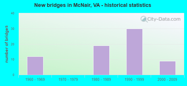
- New bridges - historical statistics
- 121960-1969
- 191980-1989
- 301990-1999
- 92000-2009

- Reconstructed bridges - Historical Statistics
- 31980-1989
- 21990-1999
- 02000-2009
- 12010-2019


- Bridge Condition - Deck
- 69.7%Good
- 27.3%Satisfactory
- 3.0%Fair

- Bridge Condition - Superstructure
- 15.2%Very good
- 57.6%Good
- 24.2%Satisfactory
- 3.0%Fair

- Bridge Condition - Substructure
- 3.0%Very good
- 57.6%Good
- 36.4%Satisfactory
- 3.0%Fair

- Bridge Condition - Channel
- 15.0%Very good
- 40.0%Good
- 40.0%Satisfactory
- 5.0%Fair

- Bridge Condition - Culverts
- 11.1%Good
- 88.9%Satisfactory
Find on map >> Show street view
Structure Number: 6805, Location: 00.2FR.665/00.30TO267 (Lat: 38.954300, Lng: -77.406558), Route carried "on" structure: County highway 657, Year Built: 1989, Status: Open, Structure Length: 1.01m (3.31ft), Average Daily Traffic: 28,105 (year 2020), Truck Traffic: 2%, Average Future Daily Traffic: 32,323 (year 2040), Design Load: HS 20+Mod, Features Intersected: TRIB. MERRYBROOK RUN, Facility Carried by Structure: CENTREVILLE ROAD
Minimum Vertical Clearance: 30+ m (98+ ft), Kilometerpoint: 12.711, Lanes on structure: 5, Owner: State Highway Agency, Approaching Roadway Width: 22.3m (73.2ft), Skew: 3 degrees, Material/Design: Concrete, Design/Construction: Culvert, Number Of Spans In Main Unit: 3, Length of Maximum Span: 3.4m (11.2ft)
Condition: Channel: Satisfactory, Culverts: Satisfactory, Operating Rating: 67.1 metric tons, Method Used To Determine Operating Rating: Load Factor (LF), Inventory Rating: 39.9 metric tons, Method Used To Determine Inventory Rating: Load Factor (LF), Structural Evaluation: Equal to present minimum criteria, Waterway Adequacy: Better than present minimum criteria, Approach Roadway Alignment: Equal to present desirable criteria, Length Of Structure Improvement: 5.12m (16.80ft), Designated Inspection Frequency: Every 24 months, Inspection Date: April 2020, Bridge Improvement Cost: $35,000, Roadway Improvement Cost: $75,000, Total Project Cost: $150,000
Find on map >> Show street view
Structure Number: 6819, Location: 00.61 665 / 00.10SCL HERN (Lat: 38.952764, Lng: -77.389003), Route carried "on" structure: County highway 666, Year Built: 1989, Status: Open, Structure Length: 11.70m (38.39ft), Average Daily Traffic: 8,111 (year 2020), Truck Traffic: 1%, Average Future Daily Traffic: 11,355 (year 2040), Design Load: HS 20, Features Intersected: RTE 267 & DAR, Facility Carried by Structure: SBL MONROE ST.
Minimum Vertical Clearance: 30+ m (98+ ft), Kilometerpoint: 0.000, Lanes on structure: 2, Lanes under structure: 12, Owner: State Highway Agency, Approaching Roadway Width: 7.9m (25.9ft), Material/Design: Steel, Design/Construction: Stringer/Multi-beam, Number Of Spans In Main Unit: 6, Length of Maximum Span: 21.6m (70.9ft), Curb or Sidewalk Widths: Left: 0.2m (0.7ft), Right: 1.5m (4.9ft), Curb-To-Curb Width: 8.1m (26.6ft), Out-to-Out Width: 10.9m (35.8ft)
Condition: Deck: Good, Superstructure: Satisfactory, Substructure: Good, Operating Rating: 90.6 metric tons, Method Used To Determine Operating Rating: Load and Resistance Factor (LRFR), Inventory Rating: 90.5 metric tons, Method Used To Determine Inventory Rating: Load and Resistance Factor (LRFR), Structural Evaluation: Equal to present minimum criteria, Deck Geometry: High priority of replacement, Underclear: High priority of replacement, Approach Roadway Alignment: Equal to present desirable criteria, Length Of Structure Improvement: 11.70m (38.39ft), Designated Inspection Frequency: Every 24 months, Inspection Date: January 2021, Bridge Improvement Cost: $1,845,000, Roadway Improvement Cost: $185,000, Total Project Cost: $2,400,000 ( Estimate for 2015), Deck Structure Type: Concrete Cast-file-Place, Wearing Surface/Protective System: Wearing Surface: Monolithic Concrete, Deck Protection: Epoxy Coated Reinforcing
Find on map >> Show street view
Structure Number: 11103, Location: 02.10 668 / 01.21 606 (Lat: 38.961978, Lng: -77.427397), Route carried "on" structure: State highway 28, Year Built: 1963, Status: Open, Structure Length: 11.86m (38.91ft), Average Daily Traffic: 52,879 (year 2020), Truck Traffic: 3%, Average Future Daily Traffic: 74,031 (year 2040), Design Load: HS 20, Features Intersected: DULLES ACCESS RD
Minimum Vertical Clearance: 30+ m (98+ ft), Kilometerpoint: 63.362, Lanes on structure: 4, Lanes under structure: 10, Base Highway Network: Yes, Owner: State Highway Agency, Approaching Roadway Width: 25.4m (83.3ft), Material/Design: Steel, Design/Construction: Stringer/Multi-beam, Number Of Spans In Main Unit: 6, Length of Maximum Span: 21.6m (70.9ft), Curb-To-Curb Width: 25.4m (83.3ft), Out-to-Out Width: 26.3m (86.3ft)
Condition: Deck: Good, Superstructure: Good, Substructure: Good, Operating Rating: 58.3 metric tons, Method Used To Determine Operating Rating: Load and Resistance Factor (LRFR), Inventory Rating: 45.0 metric tons, Method Used To Determine Inventory Rating: Load and Resistance Factor (LRFR), Structural Evaluation: Better than present minimum criteria, Deck Geometry: Superior to present desirable criteria, Underclear: High priority of corrective action, Approach Roadway Alignment: Equal to present desirable criteria, Length Of Structure Improvement: 11.86m (38.91ft), Designated Inspection Frequency: Every 24 months, Inspection Date: August 2020, Bridge Improvement Cost: $89,000, Roadway Improvement Cost: $199,000, Total Project Cost: $400,000 ( Estimate for 2014), Deck Structure Type: Concrete Cast-file-Place, Wearing Surface/Protective System: Deck Protection: Epoxy Coated Reinforcing
Find on map >> Show street view
Structure Number: 11105, Location: 00.25FR267/00.22TO209 (Lat: 38.966669, Lng: -77.428883), Route carried "on" structure: State highway 28, Year Built: 1963, Status: Open, Structure Length: 0.64m (2.10ft), Average Daily Traffic: 150,511 (year 2020), Truck Traffic: 3%, Average Future Daily Traffic: 210,715 (year 2040), Design Load: HS 20, Features Intersected: TRIBUTARY HORSEPEN RUN, Facility Carried by Structure: SULLY ROAD
Minimum Vertical Clearance: 30+ m (98+ ft), Kilometerpoint: 63.818, Lanes on structure: 8, Base Highway Network: Yes, Owner: State Highway Agency, Approaching Roadway Width: 59.7m (195.9ft), Skew: 31 degrees, Material/Design: Concrete, Design/Construction: Culvert, Number Of Spans In Main Unit: 2, Length of Maximum Span: 3.0m (9.8ft)
Condition: Channel: Fair, Culverts: Satisfactory, Operating Rating: 89.8 metric tons, Method Used To Determine Operating Rating: Load Factor (LF), Inventory Rating: 56.2 metric tons, Method Used To Determine Inventory Rating: Load Factor (LF), Structural Evaluation: Equal to present minimum criteria, Waterway Adequacy: Equal to present desirable criteria, Approach Roadway Alignment: Equal to present desirable criteria, Length Of Structure Improvement: 11.95m (39.21ft), Designated Inspection Frequency: Every 24 months, Inspection Date: May 2020, Bridge Improvement Cost: $32,000, Roadway Improvement Cost: $55,000, Total Project Cost: $100,000 ( Estimate for 2014)
Find on map >> Show street view
Structure Number: 11108, Location: 02.10FR668 / 01.21TO606 (Lat: 38.962000, Lng: -77.427631), Route carried "on" structure: State highway 28, Year Built: 1988, Status: Open, Structure Length: 11.80m (38.71ft), Average Daily Traffic: 52,879 (year 2020), Truck Traffic: 3%, Average Future Daily Traffic: 74,031 (year 2040), Design Load: HS 20+Mod, Features Intersected: DULLES ACCESS ROAD
Minimum Vertical Clearance: 30+ m (98+ ft), Kilometerpoint: 63.330, Lanes on structure: 4, Lanes under structure: 10, Base Highway Network: Yes, Owner: State Highway Agency, Approaching Roadway Width: 25.0m (82.0ft), Material/Design: Steel, Design/Construction: Stringer/Multi-beam, Number Of Spans In Main Unit: 6, Length of Maximum Span: 23.5m (77.1ft), Curb-To-Curb Width: 25.0m (82.0ft), Out-to-Out Width: 25.9m (85.0ft)
Condition: Deck: Good, Superstructure: Good, Substructure: Good, Operating Rating: 60.1 metric tons, Method Used To Determine Operating Rating: Load and Resistance Factor (LRFR), Inventory Rating: 46.4 metric tons, Method Used To Determine Inventory Rating: Load and Resistance Factor (LRFR), Structural Evaluation: Better than present minimum criteria, Deck Geometry: Superior to present desirable criteria, Underclear: High priority of corrective action, Approach Roadway Alignment: Equal to present desirable criteria, Length Of Structure Improvement: 11.80m (38.71ft), Designated Inspection Frequency: Every 24 months, Inspection Date: August 2020, Bridge Improvement Cost: $99,000, Roadway Improvement Cost: $300,000, Total Project Cost: $405,000 ( Estimate for 2014), Deck Structure Type: Concrete Cast-file-Place, Wearing Surface/Protective System: Deck Protection: Epoxy Coated Reinforcing
Find on map >> Show street view
Structure Number: 11115, Location: 00.60FR608/00.30TO-TOL.RD (Lat: 38.957472, Lng: -77.429028), Route carried "on" structure: State highway 28, Year Built: 1961, Status: Open, Structure Length: 0.82m (2.69ft), Average Daily Traffic: 105,758 (year 2020), Truck Traffic: 3%, Average Future Daily Traffic: 148,061 (year 2040), Design Load: HS 20, Features Intersected: MERRYBROOK RUN
Minimum Vertical Clearance: 30+ m (98+ ft), Kilometerpoint: 62.751, Lanes on structure: 7, Base Highway Network: Yes, Owner: State Highway Agency, Approaching Roadway Width: 44.8m (147.0ft), Skew: 34 degrees, Material/Design: Concrete, Design/Construction: Culvert, Number Of Spans In Main Unit: 2, Length of Maximum Span: 4.0m (13.1ft)
Condition: Channel: Satisfactory, Culverts: Satisfactory, Operating Rating: 87.1 metric tons, Method Used To Determine Operating Rating: Load Factor (LF), Inventory Rating: 51.7 metric tons, Method Used To Determine Inventory Rating: Load Factor (LF), Structural Evaluation: Equal to present minimum criteria, Waterway Adequacy: Equal to present desirable criteria, Approach Roadway Alignment: Equal to present desirable criteria, Length Of Structure Improvement: 17.25m (56.59ft), Designated Inspection Frequency: Every 24 months, Inspection Date: July 2021, Bridge Improvement Cost: $56,000, Roadway Improvement Cost: $75,000, Total Project Cost: $150,000 ( Estimate for 2015)
Find on map >> Show street view
Structure Number: 23615, Location: 00.30FR665/00.40TO925 (Lat: 38.952692, Lng: -77.417703), Route carried "on" structure: County highway 8161, Year Built: 1988, Status: Open, Structure Length: 0.85m (2.79ft), Average Daily Traffic: 2,137 (year 2020), Truck Traffic: 5%, Average Future Daily Traffic: 2,351 (year 2040), Design Load: HS 20, Features Intersected: MERRYBROOK RUN, Facility Carried by Structure: RIVER BIRCH ROAD
Minimum Vertical Clearance: 30+ m (98+ ft), Kilometerpoint: 0.451, Lanes on structure: 4, Owner: State Highway Agency, Approaching Roadway Width: 14.6m (47.9ft), Skew: 2 degrees, Material/Design: Concrete, Design/Construction: Culvert, Number Of Spans In Main Unit: 3, Length of Maximum Span: 2.7m (8.9ft)
Condition: Channel: Satisfactory, Culverts: Satisfactory, Operating Rating: 89.8 metric tons, Method Used To Determine Operating Rating: Load Factor (LF), Inventory Rating: 59.0 metric tons, Method Used To Determine Inventory Rating: Load Factor (LF), Structural Evaluation: Equal to present minimum criteria, Waterway Adequacy: Better than present minimum criteria, Approach Roadway Alignment: Equal to present desirable criteria, Length Of Structure Improvement: 0.46m (1.51ft), Designated Inspection Frequency: Every 24 months, Inspection Date: March 2021, Bridge Improvement Cost: $20,000, Roadway Improvement Cost: $20,000, Total Project Cost: $45,000 ( Estimate for 2015)
Find on map >> Show street view
Structure Number: 23873, Location: 00.60FR28/00.50TO DAAR (Lat: 38.963936, Lng: -77.427381), Route carried "on" structure: Ramp State highway 28, Year Built: 1994, Status: Open, Structure Length: 10.21m (33.50ft), Average Daily Traffic: 47,273 (year 2018), Truck Traffic: 3%, Average Future Daily Traffic: 34,700 (year 2034), Design Load: HS 20, Features Intersected: SULLY ROAD AND RAMP F, Facility Carried by Structure: SULLY RD. (RAMP A)
Minimum Vertical Clearance: 30+ m (98+ ft), Kilometerpoint: 0.000, Lanes on structure: 2, Lanes under structure: 10, Base Highway Network: Yes, Owner: State Highway Agency, Approaching Roadway Width: 13.7m (44.9ft), Skew: 9 degrees, Material/Design: Steel continuous, Design/Construction: Stringer/Multi-beam, Number Of Spans In Main Unit: 3, Length of Maximum Span: 39.0m (128.0ft), Curb-To-Curb Width: 12.2m (40.0ft), Out-to-Out Width: 13.3m (43.6ft)
Condition: Deck: Good, Superstructure: Good, Substructure: Satisfactory, Operating Rating: 38.1 metric tons, Method Used To Determine Operating Rating: Load and Resistance Factor (LRFR), Inventory Rating: 29.9 metric tons, Method Used To Determine Inventory Rating: Load and Resistance Factor (LRFR), Structural Evaluation: Equal to present minimum criteria, Deck Geometry: Superior to present desirable criteria, Underclear: Equal to present minimum criteria, Approach Roadway Alignment: Better than present minimum criteria, Length Of Structure Improvement: 1.52m (4.99ft), Designated Inspection Frequency: Every 24 months, Inspection Date: May 2020, Bridge Improvement Cost: $100,000, Roadway Improvement Cost: $100,000, Total Project Cost: $250,000 ( Estimate for 2014), Deck Structure Type: Concrete Cast-file-Place, Wearing Surface/Protective System: Wearing Surface: Monolithic Concrete, Deck Protection: Epoxy Coated Reinforcing
Find on map >> Show street view
Structure Number: 23879, Location: 00.30FR28/00.60TO DAAR (Lat: 38.962817, Lng: -77.425294), Route carried "on" structure: Ramp State highway 28, Year Built: 1994, Status: Open, Structure Length: 8.53m (27.99ft), Average Daily Traffic: 47,273 (year 2018), Truck Traffic: 3%, Average Future Daily Traffic: 32,600 (year 2034), Design Load: HS 20, Features Intersected: RTE.267 CD; EB & WB DAAR, Facility Carried by Structure: SULLY RD. (RAMP A)
Minimum Vertical Clearance: 30+ m (98+ ft), Kilometerpoint: 63.298, Lanes on structure: 2, Lanes under structure: 8, Base Highway Network: Yes, Owner: State Highway Agency, Approaching Roadway Width: 13.4m (44.0ft), Skew: 9 degrees, Material/Design: Steel continuous, Design/Construction: Stringer/Multi-beam, Number Of Spans In Main Unit: 2, Length of Maximum Span: 49.1m (161.1ft), Curb-To-Curb Width: 12.5m (41.0ft), Out-to-Out Width: 13.6m (44.6ft)
Condition: Deck: Good, Superstructure: Good, Substructure: Satisfactory, Operating Rating: 63.5 metric tons, Method Used To Determine Operating Rating: Load and Resistance Factor (LRFR), Inventory Rating: 49.0 metric tons, Method Used To Determine Inventory Rating: Load and Resistance Factor (LRFR), Structural Evaluation: Equal to present minimum criteria, Deck Geometry: Superior to present desirable criteria, Underclear: High priority of corrective action, Approach Roadway Alignment: Better than present minimum criteria, Length Of Structure Improvement: 0.46m (1.51ft), Designated Inspection Frequency: Every 24 months, Inspection Date: May 2020, Bridge Improvement Cost: $41,000, Roadway Improvement Cost: $50,000, Total Project Cost: $100,000 ( Estimate for 2014), Deck Structure Type: Concrete Cast-file-Place, Wearing Surface/Protective System: Wearing Surface: Monolithic Concrete, Deck Protection: Epoxy Coated Reinforcing
Find on map >> Show street view
Structure Number: 23883, Location: 00.75FR28/00.20TO DAAR (Lat: 38.963681, Lng: -77.430453), Route carried "on" structure: Ramp State highway 28, Year Built: 1994, Status: Open, Structure Length: 4.97m (16.31ft), Average Daily Traffic: 5,000 (year 1994), Truck Traffic: 2%, Average Future Daily Traffic: 15,000 (year 2034), Design Load: HS 20+Mod, Features Intersected: HORSEPEN RUN, Facility Carried by Structure: SULLY RD. (RAMP A)
Minimum Vertical Clearance: 30+ m (98+ ft), Kilometerpoint: 0.000, Lanes on structure: 2, Base Highway Network: Yes, Owner: State Highway Agency, Approaching Roadway Width: 13.7m (44.9ft), Skew: 2 degrees, Material/Design: Steel continuous, Design/Construction: Stringer/Multi-beam, Number Of Spans In Main Unit: 3, Length of Maximum Span: 20.4m (66.9ft), Curb-To-Curb Width: 12.2m (40.0ft), Out-to-Out Width: 13.3m (43.6ft)
Condition: Deck: Good, Superstructure: Good, Substructure: Good, Channel: Good, Operating Rating: 68.9 metric tons, Method Used To Determine Operating Rating: Load and Resistance Factor (LRFR), Inventory Rating: 51.7 metric tons, Method Used To Determine Inventory Rating: Load and Resistance Factor (LRFR), Structural Evaluation: Better than present minimum criteria, Deck Geometry: Superior to present desirable criteria, Waterway Adequacy: Equal to present desirable criteria, Approach Roadway Alignment: Better than present minimum criteria, Length Of Structure Improvement: 0.30m (0.98ft), Designated Inspection Frequency: Every 24 months, Inspection Date: May 2020, Bridge Improvement Cost: $1,000, Roadway Improvement Cost: $1,000, Total Project Cost: $3,000 ( Estimate for 2014), Deck Structure Type: Concrete Cast-file-Place, Wearing Surface/Protective System: Wearing Surface: Monolithic Concrete, Deck Protection: Epoxy Coated Reinforcing
Find on map >> Show street view
Structure Number: 24101, Location: 02.60FR606/01.40TO657 (Lat: 38.965525, Lng: -77.428961), Route carried "on" structure: Other road 267, Year Built: 1995, Status: Open, Structure Length: 12.25m (40.19ft), Average Daily Traffic: 43,927 (year 2020), Truck Traffic: 2%, Average Future Daily Traffic: 61,498 (year 2040), Design Load: HS 20+Mod, Features Intersected: SULLY ROAD (RTE. 28), Facility Carried by Structure: DULLES GREENWAY WB
Minimum Vertical Clearance: 30+ m (98+ ft), Kilometerpoint: 21.609, Lanes on structure: 2, Lanes under structure: 10, Base Highway Network: Yes, Toll: On toll road, Owner: Local Toll Authority, Approaching Roadway Width: 12.8m (42.0ft), Skew: 5 degrees, Material/Design: Steel continuous, Design/Construction: Stringer/Multi-beam, Number Of Spans In Main Unit: 2, Length of Maximum Span: 65.2m (213.9ft), Curb-To-Curb Width: 12.8m (42.0ft), Out-to-Out Width: 13.9m (45.6ft)
Condition: Deck: Satisfactory, Superstructure: Satisfactory, Substructure: Satisfactory, Operating Rating: 63.0 metric tons, Method Used To Determine Operating Rating: Load Factor (LF), Inventory Rating: 37.7 metric tons, Method Used To Determine Inventory Rating: Load Factor (LF), Structural Evaluation: Equal to present minimum criteria, Deck Geometry: Equal to present desirable criteria, Underclear: Better than present minimum criteria, Approach Roadway Alignment: Equal to present desirable criteria, Length Of Structure Improvement: 3.05m (10.01ft), Designated Inspection Frequency: Every 24 months, Inspection Date: January 2021, Bridge Improvement Cost: $10,000, Roadway Improvement Cost: $10,000, Total Project Cost: $25,000 ( Estimate for 2015), Deck Structure Type: Concrete Cast-file-Place, Wearing Surface/Protective System: Wearing Surface: Monolithic Concrete, Deck Protection: Epoxy Coated Reinforcing
Find on map >> Show street view
Structure Number: 24103, Location: 02.60FR606/01.40TO657 (Lat: 38.964989, Lng: -77.428647), Route carried "on" structure: Other road 267, Year Built: 1995, Year Reconstructed: 2019, Status: Open, Structure Length: 12.37m (40.58ft), Average Daily Traffic: 42,485 (year 2020), Truck Traffic: 2%, Average Future Daily Traffic: 59,479 (year 2040), Design Load: HS 20, Features Intersected: SULLY ROAD (ROUTE 28), Facility Carried by Structure: DULLES GREENWAY EB
Minimum Vertical Clearance: 30+ m (98+ ft), Kilometerpoint: 21.609, Lanes on structure: 2, Lanes under structure: 10, Base Highway Network: Yes, Toll: On toll road, Owner: Local Toll Authority, Approaching Roadway Width: 16.8m (55.1ft), Skew: 5 degrees, Material/Design: Steel continuous, Design/Construction: Stringer/Multi-beam, Number Of Spans In Main Unit: 2, Length of Maximum Span: 65.2m (213.9ft), Curb-To-Curb Width: 18.3m (60.0ft), Out-to-Out Width: 19.3m (63.3ft)
Condition: Deck: Satisfactory, Superstructure: Satisfactory, Substructure: Satisfactory, Operating Rating: 63.5 metric tons, Method Used To Determine Operating Rating: Load and Resistance Factor (LRFR), Inventory Rating: 49.0 metric tons, Method Used To Determine Inventory Rating: Load and Resistance Factor (LRFR), Structural Evaluation: Equal to present minimum criteria, Deck Geometry: Superior to present desirable criteria, Underclear: Equal to present minimum criteria, Approach Roadway Alignment: Equal to present desirable criteria, Length Of Structure Improvement: 3.05m (10.01ft), Designated Inspection Frequency: Every 24 months, Inspection Date: January 2021, Bridge Improvement Cost: $10,000, Roadway Improvement Cost: $10,000, Total Project Cost: $25,000 ( Estimate for 2015), Deck Structure Type: Concrete Cast-file-Place, Wearing Surface/Protective System: Wearing Surface: Monolithic Concrete, Deck Protection: Epoxy Coated Reinforcing
Find on map >> Show street view
Structure Number: 24584, Location: 02.50FR606/01.50TO657 (Lat: 38.965878, Lng: -77.430347), Route carried "on" structure: Other road 267, Year Built: 1994, Status: Open, Structure Length: 1.28m (4.20ft), Average Daily Traffic: 86,412 (year 2020), Truck Traffic: 2%, Average Future Daily Traffic: 119,214 (year 2040), Design Load: HS 20+Mod, Features Intersected: TRIB. HORSEPEN RUN, Facility Carried by Structure: DULLES GREENWAY
Minimum Vertical Clearance: 30+ m (98+ ft), Kilometerpoint: 21.561, Lanes on structure: 5, Base Highway Network: Yes, Toll: On toll road, Owner: Local Toll Authority, Approaching Roadway Width: 27.7m (90.9ft), Skew: 3 degrees, Material/Design: Concrete, Design/Construction: Culvert, Number Of Spans In Main Unit: 3, Length of Maximum Span: 4.3m (14.1ft)
Condition: Channel: Satisfactory, Culverts: Satisfactory, Operating Rating: 89.8 metric tons, Method Used To Determine Operating Rating: Load Factor (LF), Inventory Rating: 89.8 metric tons, Method Used To Determine Inventory Rating: Load Factor (LF), Structural Evaluation: Equal to present minimum criteria, Waterway Adequacy: Better than present minimum criteria, Approach Roadway Alignment: Equal to present desirable criteria, Length Of Structure Improvement: 0.30m (0.98ft), Designated Inspection Frequency: Every 24 months, Inspection Date: August 2020, Bridge Improvement Cost: $1,000, Roadway Improvement Cost: $1,000, Total Project Cost: $3,000 ( Estimate for 2016)
Find on map >> Show street view
Structure Number: 24603, Location: 00.15FR28NB/02.35TO606 (Lat: 38.968750, Lng: -77.429317), Route carried "on" structure: Ramp Other road 267, Year Built: 1995, Status: Open, Structure Length: 10.94m (35.89ft), Average Daily Traffic: 47,273 (year 2018), Truck Traffic: 3%, Average Future Daily Traffic: 15,000 (year 2034), Design Load: HS 20, Features Intersected: SULLY ROAD SBL (RTE. 28), Facility Carried by Structure: D. GREENWAY RAMP I
Minimum Vertical Clearance: 30+ m (98+ ft), Kilometerpoint: 0.000, Lanes on structure: 1, Lanes under structure: 4, Base Highway Network: Yes, Toll: On toll road, Owner: Local Toll Authority, Approaching Roadway Width: 9.1m (29.9ft), Material/Design: Steel continuous, Design/Construction: Stringer/Multi-beam, Number Of Spans In Main Unit: 2, Length of Maximum Span: 54.6m (179.1ft), Curb-To-Curb Width: 9.1m (29.9ft), Out-to-Out Width: 10.2m (33.5ft)
Condition: Deck: Satisfactory, Superstructure: Satisfactory, Substructure: Good, Operating Rating: 49.0 metric tons, Method Used To Determine Operating Rating: Load and Resistance Factor (LRFR), Inventory Rating: 38.1 metric tons, Method Used To Determine Inventory Rating: Load and Resistance Factor (LRFR), Structural Evaluation: Equal to present minimum criteria, Deck Geometry: Superior to present desirable criteria, Underclear: Superior to present desirable criteria, Approach Roadway Alignment: Equal to present desirable criteria, Length Of Structure Improvement: 3.05m (10.01ft), Designated Inspection Frequency: Every 24 months, Critical Feature Inspection Frequency: Every 24 months, Inspection Date: May 2020, Critical Feature Inspection Date: May 2021, Bridge Improvement Cost: $1,000, Roadway Improvement Cost: $1,000, Total Project Cost: $3,000 ( Estimate for 2016), Deck Structure Type: Concrete Cast-file-Place, Wearing Surface/Protective System: Wearing Surface: Monolithic Concrete, Deck Protection: Epoxy Coated Reinforcing
Find on map >> Show street view
Structure Number: 24604, Location: 03.00FR606/01.10TO657 (Lat: 38.962822, Lng: -77.424325), Route carried "on" structure: Other road 267, Year Built: 1995, Status: Open, Structure Length: 21.15m (69.39ft), Average Daily Traffic: 42,485 (year 2020), Truck Traffic: 2%, Average Future Daily Traffic: 59,479 (year 2040), Design Load: HS 20+Mod, Features Intersected: EBL 267 CD; RAMP B; DAAR, Facility Carried by Structure: DULLES GREENWAY EB
Minimum Vertical Clearance: 30+ m (98+ ft), Kilometerpoint: 21.915, Lanes on structure: 2, Lanes under structure: 9, Base Highway Network: Yes, Toll: On toll road, Owner: Local Toll Authority, Approaching Roadway Width: 11.9m (39.0ft), Skew: 7 degrees, Material/Design: Steel continuous, Design/Construction: Stringer/Multi-beam, Number Of Spans In Main Unit: 3, Length of Maximum Span: 71.9m (235.9ft), Curb-To-Curb Width: 12.8m (42.0ft), Out-to-Out Width: 13.9m (45.6ft)
Condition: Deck: Satisfactory, Superstructure: Satisfactory, Substructure: Satisfactory, Operating Rating: 66.3 metric tons, Method Used To Determine Operating Rating: Load and Resistance Factor (LRFR), Inventory Rating: 51.3 metric tons, Method Used To Determine Inventory Rating: Load and Resistance Factor (LRFR), Structural Evaluation: Equal to present minimum criteria, Deck Geometry: Equal to present desirable criteria, Underclear: Equal to present minimum criteria, Approach Roadway Alignment: Better than present minimum criteria, Length Of Structure Improvement: 3.05m (10.01ft), Designated Inspection Frequency: Every 24 months, Inspection Date: January 2021, Bridge Improvement Cost: $10,000, Roadway Improvement Cost: $10,000, Total Project Cost: $25,000 ( Estimate for 2015), Deck Structure Type: Concrete Cast-file-Place, Wearing Surface/Protective System: Wearing Surface: Monolithic Concrete, Deck Protection: Epoxy Coated Reinforcing
Find on map >> Show street view
Structure Number: 27174, Location: 01.00FR28/01.00TO606 (Lat: 38.963758, Lng: -77.416583), Route carried "on" structure: Alternate County highway 847, Year Built: 2002, Status: Open, Structure Length: 1.01m (3.31ft), Average Daily Traffic: 2,627 (year 2009), Average Future Daily Traffic: 3,034 (year 2040), Design Load: HS 20+Mod, Features Intersected: TRIB. OF HORSEPEN RUN, Facility Carried by Structure: INNOVATION AVE.
Minimum Vertical Clearance: 30+ m (98+ ft), Kilometerpoint: 0.000, Lanes on structure: 4, Owner: State Highway Agency, Approaching Roadway Width: 7.9m (25.9ft), Skew: 30 degrees, Material/Design: Concrete, Design/Construction: Arch - Deck, Number Of Spans In Main Unit: 1, Length of Maximum Span: 9.8m (32.2ft), Curb or Sidewalk Widths: Left: 1.5m (4.9ft), Right: 0.0m, Curb-To-Curb Width: 21.9m (71.9ft), Out-to-Out Width: 97.5m (319.9ft)
Condition: Deck: Good, Superstructure: Good, Substructure: Very good, Channel: Good, Operating Rating: 50.8 metric tons, Method Used To Determine Operating Rating: Load Factor (LF), Inventory Rating: 42.1 metric tons, Method Used To Determine Inventory Rating: Load Factor (LF), Structural Evaluation: Better than present minimum criteria, Deck Geometry: Superior to present desirable criteria, Waterway Adequacy: Better than present minimum criteria, Approach Roadway Alignment: Equal to present desirable criteria, Length Of Structure Improvement: 1.01m (3.31ft), Designated Inspection Frequency: Every 24 months, Inspection Date: April 2020, Bridge Improvement Cost: $25,000, Roadway Improvement Cost: $49,000, Total Project Cost: $100,000 ( Estimate for 2014), Deck Structure Type: Concrete Precast Panels, Wearing Surface/Protective System: Wearing Surface: Bituminous
Find on map >> Show street view
Structure Number: 30859, Location: 00.28fr28 00.57to605 (Lat: 38.968419, Lng: -77.424675), Route carried "on" structure: Alternate County highway 880, Year Built: 2000, Status: Open, Structure Length: 1.07m (3.51ft), Average Daily Traffic: 2,086 (year 2015), Truck Traffic: 2%, Average Future Daily Traffic: 2,295 (year 2035), Design Load: HS 20, Features Intersected: TRIB. HORSEPEN RUN, Facility Carried by Structure: INNOVATION DRIVE
Minimum Vertical Clearance: 30.18m (99.02ft), Kilometerpoint: 0.000, Lanes on structure: 4, Owner: State Highway Agency, Approaching Roadway Width: 11.6m (38.1ft), Skew: 3 degrees, Material/Design: Concrete, Design/Construction: Culvert, Number Of Spans In Main Unit: 3, Length of Maximum Span: 3.0m (9.8ft)
Condition: Channel: Good, Culverts: Good, Operating Rating: 89.8 metric tons, Method Used To Determine Operating Rating: Load Factor (LF), Inventory Rating: 89.7 metric tons, Method Used To Determine Inventory Rating: Load Factor (LF), Structural Evaluation: Better than present minimum criteria, Waterway Adequacy: Better than present minimum criteria, Approach Roadway Alignment: Better than present minimum criteria, Designated Inspection Frequency: Every 24 months, Inspection Date: November 2020
Find on map >> Show street view
Structure Number: 2100001P, Location: 0.2 MILES FROM DULLES AIR (Lat: 38.955250, Lng: -77.444500), Route carried "on" structure: Ramp Other road 101, Year Built: 1961, Status: Open, Structure Length: 6.99m (22.93ft), Average Daily Traffic: 10,000 (year 2006), Average Future Daily Traffic: 12,000 (year 2026), Design Load: HS 15, Features Intersected: TOLL PLAZA, Facility Carried by Structure: SAARINEN CIRCLE
Minimum Vertical Clearance: 30+ m (98+ ft), Kilometerpoint: 0.320, Lanes on structure: 1, Lanes under structure: 7, Owner: Metropolitan Washington Airports Service, Approaching Roadway Width: 6.7m (22.0ft), Skew: 4 degrees, Material/Design: Concrete continuous, Design/Construction: Slab, Number Of Spans In Main Unit: 10, Length of Maximum Span: 9.6m (31.5ft), Curb or Sidewalk Widths: Left: 0.5m (1.6ft), Right: 0.5m (1.6ft), Curb-To-Curb Width: 5.5m (18.0ft), Out-to-Out Width: 7.0m (23.0ft)
Condition: Deck: Satisfactory, Superstructure: Satisfactory, Substructure: Good, Operating Rating: 40.8 metric tons, Method Used To Determine Operating Rating: Allowable Stress (AS), Inventory Rating: 24.0 metric tons, Method Used To Determine Inventory Rating: Allowable Stress (AS), Structural Evaluation: Somewhat better than minimum adequacy, Deck Geometry: Meets minimum limits, Underclear: High priority of corrective action, Approach Roadway Alignment: Equal to present desirable criteria, Designated Inspection Frequency: Every 24 months, Inspection Date: September 2019, Deck Structure Type: Concrete Cast-file-Place
Find on map >> Show street view
Structure Number: 2100002P, Location: 0.9 MILES TO DULLES AIRPO (Lat: 38.958139, Lng: -77.444139), Route carried "on" structure: ServiceOther road 104, Year Built: 1961, Year Reconstructed: 2003, Status: Open, Structure Length: 7.19m (23.59ft), Average Daily Traffic: 10,000 (year 2006), Average Future Daily Traffic: 12,000 (year 2026), Design Load: HS 20, Features Intersected: DULLES ACCESS ROAD, Facility Carried by Structure: AVIATION DRIVE
Minimum Vertical Clearance: 30+ m (98+ ft), Kilometerpoint: 1.450, Lanes on structure: 3, Lanes under structure: 7, Owner: Metropolitan Washington Airports Service, Approaching Roadway Width: 25.6m (84.0ft), Skew: 20 degrees, Material/Design: Steel, Design/Construction: Stringer/Multi-beam, Number Of Spans In Main Unit: 4, Length of Maximum Span: 25.9m (85.0ft), Curb or Sidewalk Widths: Left: 0.2m (0.7ft), Right: 0.5m (1.6ft), Curb-To-Curb Width: 18.6m (61.0ft), Out-to-Out Width: 26.2m (86.0ft)
Condition: Deck: Satisfactory, Superstructure: Satisfactory, Substructure: Fair, Operating Rating: 54.4 metric tons, Method Used To Determine Operating Rating: Allowable Stress (AS), Inventory Rating: 33.0 metric tons, Method Used To Determine Inventory Rating: Allowable Stress (AS), Structural Evaluation: Somewhat better than minimum adequacy, Deck Geometry: Superior to present desirable criteria, Underclear: Meets minimum limits, Approach Roadway Alignment: Equal to present desirable criteria, Designated Inspection Frequency: Every 24 months, Inspection Date: September 2019, Bridge Improvement Cost: $240,000, Roadway Improvement Cost: $24,000, Total Project Cost: $360,000 ( Estimate for 2017), Deck Structure Type: Concrete Cast-file-Place, Wearing Surface/Protective System: Wearing Surface: Monolithic Concrete
Find on map >> Show street view
Structure Number: 2100003P, Location: 1.3 MILES FROM DULLES AIR (Lat: 38.962583, Lng: -77.430972), Route carried "on" structure: Other road 2, Year Built: 1960, Year Reconstructed: 1985, Status: Open, Structure Length: 4.12m (13.52ft), Average Daily Traffic: 13,000 (year 2011), Truck Traffic: 12%, Average Future Daily Traffic: 14,300 (year 2031), Design Load: HS 20, Features Intersected: HORSEPEN RUN, Facility Carried by Structure: WB DULLES ACCESS R
Minimum Vertical Clearance: 30+ m (98+ ft), Kilometerpoint: 2.090, Lanes on structure: 2, Owner: Metropolitan Washington Airports Service, Approaching Roadway Width: 11.3m (37.1ft), Material/Design: Steel, Design/Construction: Stringer/Multi-beam, Number Of Spans In Main Unit: 3, Length of Maximum Span: 18.3m (60.0ft), Curb-To-Curb Width: 16.2m (53.1ft), Out-to-Out Width: 17.5m (57.4ft)
Condition: Deck: Satisfactory, Superstructure: Good, Substructure: Satisfactory, Channel: Good, Operating Rating: 54.4 metric tons, Method Used To Determine Operating Rating: Allowable Stress (AS), Inventory Rating: 33.0 metric tons, Method Used To Determine Inventory Rating: Allowable Stress (AS), Structural Evaluation: Equal to present minimum criteria, Deck Geometry: Superior to present desirable criteria, Waterway Adequacy: Equal to present minimum criteria, Approach Roadway Alignment: Equal to present desirable criteria, Designated Inspection Frequency: Every 24 months, Inspection Date: September 2019, Bridge Improvement Cost: $25,000, Roadway Improvement Cost: $3,000, Total Project Cost: $38,000 ( Estimate for 2017), Deck Structure Type: Concrete Cast-file-Place, Wearing Surface/Protective System: Wearing Surface: Monolithic Concrete
Find on map >> Show street view
Structure Number: 2100004P, Location: 1.3 MILES FROM DULLES AIR (Lat: 38.962583, Lng: -77.430944), Route carried "on" structure: Other road 1, Year Built: 1960, Year Reconstructed: 1985, Status: Open, Structure Length: 4.12m (13.52ft), Average Daily Traffic: 13,000 (year 2006), Truck Traffic: 12%, Average Future Daily Traffic: 14,300 (year 2026), Design Load: HS 20, Features Intersected: HORSEPEN RUN, Facility Carried by Structure: EB DULLES ACCESS R
Minimum Vertical Clearance: 30+ m (98+ ft), Kilometerpoint: 2.090, Lanes on structure: 2, Owner: Metropolitan Washington Airports Service, Approaching Roadway Width: 11.3m (37.1ft), Material/Design: Steel, Design/Construction: Stringer/Multi-beam, Number Of Spans In Main Unit: 3, Length of Maximum Span: 18.3m (60.0ft), Curb-To-Curb Width: 16.8m (55.1ft), Out-to-Out Width: 18.0m (59.1ft)
Condition: Deck: Satisfactory, Superstructure: Good, Substructure: Satisfactory, Channel: Good, Operating Rating: 54.4 metric tons, Method Used To Determine Operating Rating: Allowable Stress (AS), Inventory Rating: 33.0 metric tons, Method Used To Determine Inventory Rating: Allowable Stress (AS), Structural Evaluation: Equal to present minimum criteria, Deck Geometry: Superior to present desirable criteria, Waterway Adequacy: Equal to present minimum criteria, Approach Roadway Alignment: Equal to present desirable criteria, Designated Inspection Frequency: Every 24 months, Inspection Date: September 2019, Bridge Improvement Cost: $30,000, Roadway Improvement Cost: $3,000, Total Project Cost: $45,000 ( Estimate for 2017), Deck Structure Type: Concrete Cast-file-Place, Wearing Surface/Protective System: Wearing Surface: Monolithic Concrete
Find on map >> Show street view
Structure Number: 2100006P, Location: 1.3 MILES FROM DULLES AIR (Lat: 38.961361, Lng: -77.431056), Route carried "on" structure: Ramp Other road 110, Year Built: 1960, Year Reconstructed: 1985, Status: Open, Structure Length: 4.37m (14.34ft), Average Daily Traffic: 10,000 (year 2006), Average Future Daily Traffic: 12,000 (year 2026), Design Load: HS 20, Features Intersected: HORSEPEN RUN, Facility Carried by Structure: OLD EASTBOUND EXIT
Minimum Vertical Clearance: 30+ m (98+ ft), Kilometerpoint: 2.090, Lanes on structure: 2, Owner: Metropolitan Washington Airports Service, Approaching Roadway Width: 8.5m (27.9ft), Skew: 1 degrees, Material/Design: Steel, Design/Construction: Stringer/Multi-beam, Number Of Spans In Main Unit: 3, Length of Maximum Span: 19.4m (63.6ft), Curb-To-Curb Width: 8.5m (27.9ft), Out-to-Out Width: 10.1m (33.1ft)
Condition: Deck: Fair, Superstructure: Good, Substructure: Satisfactory, Channel: Very good, Operating Rating: 54.4 metric tons, Method Used To Determine Operating Rating: Allowable Stress (AS), Inventory Rating: 33.0 metric tons, Method Used To Determine Inventory Rating: Allowable Stress (AS), Structural Evaluation: Equal to present minimum criteria, Deck Geometry: High priority of corrective action, Waterway Adequacy: Equal to present desirable criteria, Approach Roadway Alignment: Equal to present desirable criteria, Designated Inspection Frequency: Every 24 months, Inspection Date: September 2019, Bridge Improvement Cost: $70,000, Roadway Improvement Cost: $7,000, Total Project Cost: $105,000 ( Estimate for 2017), Deck Structure Type: Concrete Cast-file-Place, Wearing Surface/Protective System: Wearing Surface: Monolithic Concrete
Find on map >> Show street view
Structure Number: 2100024P, Location: 0.75 MILES TO VA ROUTE 28 (Lat: 38.961528, Lng: -77.441278), Route carried "on" structure: Other road , Year Built: 1989, Status: Open, Structure Length: 12.07m (39.60ft), Average Daily Traffic: 10,000 (year 2006), Average Future Daily Traffic: 12,000 (year 2026), Design Load: HS 20, Features Intersected: DULLES ACCESS ROAD, Facility Carried by Structure: ROAD "A" EXTENSION
Minimum Vertical Clearance: 30+ m (98+ ft), Kilometerpoint: 2.250, Lanes on structure: 2, Lanes under structure: 11, Owner: Metropolitan Washington Airports Service, Approaching Roadway Width: 15.8m (51.8ft), Skew: 30 degrees, Material/Design: Steel continuous, Design/Construction: Stringer/Multi-beam, Number Of Spans In Main Unit: 3, Length of Maximum Span: 42.7m (140.1ft), Curb-To-Curb Width: 15.3m (50.2ft), Out-to-Out Width: 17.0m (55.8ft)
Condition: Deck: Satisfactory, Superstructure: Good, Substructure: Satisfactory, Operating Rating: 54.4 metric tons, Method Used To Determine Operating Rating: Allowable Stress (AS), Inventory Rating: 33.0 metric tons, Method Used To Determine Inventory Rating: Allowable Stress (AS), Structural Evaluation: Equal to present minimum criteria, Deck Geometry: Superior to present desirable criteria, Underclear: Better than present minimum criteria, Approach Roadway Alignment: Equal to present desirable criteria, Designated Inspection Frequency: Every 24 months, Inspection Date: September 2019, Bridge Improvement Cost: $55,000, Roadway Improvement Cost: $6,000, Total Project Cost: $83,000 ( Estimate for 2017), Deck Structure Type: Concrete Cast-file-Place, Wearing Surface/Protective System: Wearing Surface: Monolithic Concrete
Find on map >> Show street view
Structure Number: 2100025P, Location: 0.1 MILES FROM DULLES ACC (Lat: 38.965611, Lng: -77.443611), Route carried "on" structure: Other road , Year Built: 1989, Status: Open, Structure Length: 1.64m (5.38ft), Average Daily Traffic: 5,000 (year 2006), Average Future Daily Traffic: 6,000 (year 2026), Features Intersected: CREEK, Facility Carried by Structure: SOUTH ACCESS SATEL
Minimum Vertical Clearance: 30+ m (98+ ft), Kilometerpoint: 0.000, Lanes on structure: 2, Toll: On toll road, Owner: Metropolitan Washington Airports Service, Approaching Roadway Width: 9.8m (32.2ft), Material/Design: Steel, Design/Construction: Culvert, Number Of Spans In Main Unit: 2, Length of Maximum Span: 7.3m (24.0ft)
Condition: Channel: Satisfactory, Culverts: Satisfactory, Operating Rating: 40.8 metric tons, Method Used To Determine Operating Rating: Allowable Stress (AS), Inventory Rating: 24.5 metric tons, Method Used To Determine Inventory Rating: Allowable Stress (AS), Structural Evaluation: Equal to present minimum criteria, Waterway Adequacy: Equal to present desirable criteria, Approach Roadway Alignment: Equal to present desirable criteria, Designated Inspection Frequency: Every 24 months, Inspection Date: September 2019
Find on map >> Show street view
Structure Number: 2100026P, Location: 0.15 MILES FROM DULLES AC (Lat: 38.967000, Lng: -77.444444), Route carried "on" structure: Other road , Year Built: 1989, Status: Open, Structure Length: 1.64m (5.38ft), Average Daily Traffic: 5,000 (year 2006), Average Future Daily Traffic: 6,000 (year 2026), Features Intersected: CREEK, Facility Carried by Structure: NORTH ACCESS SATEL
Minimum Vertical Clearance: 30+ m (98+ ft), Kilometerpoint: 0.000, Lanes on structure: 2, Toll: On toll road, Owner: Metropolitan Washington Airports Service, Approaching Roadway Width: 8.5m (27.9ft), Material/Design: Steel, Design/Construction: Culvert, Number Of Spans In Main Unit: 2, Length of Maximum Span: 7.3m (24.0ft)
Condition: Channel: Satisfactory, Culverts: Satisfactory, Operating Rating: 40.8 metric tons, Method Used To Determine Operating Rating: Allowable Stress (AS), Inventory Rating: 24.5 metric tons, Method Used To Determine Inventory Rating: Allowable Stress (AS), Structural Evaluation: Equal to present minimum criteria, Waterway Adequacy: Equal to present desirable criteria, Approach Roadway Alignment: Equal to present desirable criteria, Designated Inspection Frequency: Every 24 months, Inspection Date: September 2019
Find on map >> Show street view
Structure Number: 2100028P, Location: DULLES AIRPORT TERMINAL E (Lat: 38.953833, Lng: -77.451417), Route carried "on" structure: Other road , Year Built: 1993, Status: Open, Structure Length: 4.02m (13.19ft), Average Daily Traffic: 13,000 (year 2006), Average Future Daily Traffic: 14,300 (year 2026), Design Load: HS 20, Features Intersected: COMMERCIAL VEHICLE DRIVE, Facility Carried by Structure: SAARINEN CIRCLE
Minimum Vertical Clearance: 30+ m (98+ ft), Kilometerpoint: 0.000, Lanes on structure: 4, Lanes under structure: 2, Owner: Metropolitan Washington Airports Service, Approaching Roadway Width: 15.8m (51.8ft), Skew: 23 degrees, Material/Design: Concrete continuous, Design/Construction: Box Beam or Girders - Single/Spread, Number Of Spans In Main Unit: 3, Length of Maximum Span: 16.8m (55.1ft), Curb or Sidewalk Widths: Left: 3.0m (9.8ft), Right: 3.0m (9.8ft), Curb-To-Curb Width: 23.1m (75.8ft), Out-to-Out Width: 26.6m (87.3ft)
Condition: Deck: Good, Superstructure: Good, Substructure: Good, Operating Rating: 54.4 metric tons, Method Used To Determine Operating Rating: Allowable Stress (AS), Inventory Rating: 33.0 metric tons, Method Used To Determine Inventory Rating: Allowable Stress (AS), Structural Evaluation: Better than present minimum criteria, Deck Geometry: Superior to present desirable criteria, Underclear: Meets minimum limits, Approach Roadway Alignment: Equal to present desirable criteria, Designated Inspection Frequency: Every 24 months, Inspection Date: September 2019, Deck Structure Type: Concrete Cast-file-Place, Wearing Surface/Protective System: Wearing Surface: Bituminous, Deck Protection: Epoxy Coated Reinforcing
Find on map >> Show street view
Structure Number: 2100029P, Location: DULLES AIRPORT TERMINAL E (Lat: 38.953472, Lng: -77.444500), Route carried "on" structure: Other road , Year Built: 1993, Status: Open, Structure Length: 4.18m (13.71ft), Average Daily Traffic: 13,000 (year 2006), Average Future Daily Traffic: 14,300 (year 2026), Design Load: HS 20, Features Intersected: COMMERCIAL VEHICLE DRIVE, Facility Carried by Structure: SAARINEN CIRCLE
Minimum Vertical Clearance: 30+ m (98+ ft), Kilometerpoint: 0.000, Lanes on structure: 4, Lanes under structure: 2, Owner: Metropolitan Washington Airports Service, Approaching Roadway Width: 15.8m (51.8ft), Skew: 23 degrees, Material/Design: Concrete continuous, Design/Construction: Box Beam or Girders - Single/Spread, Number Of Spans In Main Unit: 3, Length of Maximum Span: 18.0m (59.1ft), Curb or Sidewalk Widths: Left: 3.0m (9.8ft), Right: 3.0m (9.8ft), Curb-To-Curb Width: 23.9m (78.4ft), Out-to-Out Width: 26.6m (87.3ft)
Condition: Deck: Good, Superstructure: Good, Substructure: Good, Operating Rating: 54.4 metric tons, Method Used To Determine Operating Rating: Allowable Stress (AS), Inventory Rating: 33.0 metric tons, Method Used To Determine Inventory Rating: Allowable Stress (AS), Structural Evaluation: Better than present minimum criteria, Deck Geometry: Superior to present desirable criteria, Underclear: Meets minimum limits, Approach Roadway Alignment: Equal to present desirable criteria, Designated Inspection Frequency: Every 24 months, Inspection Date: September 2019, Deck Structure Type: Concrete Cast-file-Place, Wearing Surface/Protective System: Wearing Surface: Bituminous, Deck Protection: Epoxy Coated Reinforcing
Find on map >> Show street view
Structure Number: 2100030P, Location: 1.3 MILES FROM DULLES AIR (Lat: 38.963500, Lng: -77.430917), Route carried "on" structure: Ramp Other road , Year Built: 1997, Status: Open, Structure Length: 4.97m (16.31ft), Average Daily Traffic: 13,000 (year 2006), Truck Traffic: 12%, Average Future Daily Traffic: 14,300 (year 2026), Design Load: HS 20, Features Intersected: HORSEPEN RUN, Facility Carried by Structure: WB DULLES ACCESS R
Minimum Vertical Clearance: 30+ m (98+ ft), Kilometerpoint: 2.090, Lanes on structure: 2, Toll: On toll road, Owner: Metropolitan Washington Airports Service, Approaching Roadway Width: 12.1m (39.7ft), Skew: 2 degrees, Material/Design: Steel continuous, Design/Construction: Stringer/Multi-beam, Number Of Spans In Main Unit: 3, Length of Maximum Span: 20.4m (66.9ft), Curb-To-Curb Width: 12.2m (40.0ft), Out-to-Out Width: 13.1m (43.0ft)
Condition: Deck: Good, Superstructure: Good, Substructure: Good, Channel: Satisfactory, Operating Rating: 54.4 metric tons, Method Used To Determine Operating Rating: Allowable Stress (AS), Inventory Rating: 33.0 metric tons, Method Used To Determine Inventory Rating: Allowable Stress (AS), Structural Evaluation: Better than present minimum criteria, Deck Geometry: Superior to present desirable criteria, Waterway Adequacy: Equal to present desirable criteria, Approach Roadway Alignment: Equal to present desirable criteria, Designated Inspection Frequency: Every 24 months, Inspection Date: September 2019, Bridge Improvement Cost: $10,000, Roadway Improvement Cost: $1,000, Total Project Cost: $15,000 ( Estimate for 2017), Deck Structure Type: Concrete Cast-file-Place
Find on map >> Show street view
Structure Number: 2100031P, Location: 1.0 MILES FROM DULLES AIR (Lat: 38.961528, Lng: -77.441167), Route carried "on" structure: Ramp Other road , Year Built: 1996, Status: Open, Structure Length: 13.21m (43.34ft), Average Daily Traffic: 10,000 (year 2006), Average Future Daily Traffic: 12,000 (year 2026), Design Load: HS 20, Features Intersected: DULLES ACCESS ROAD, Facility Carried by Structure: RAMP "G"
Minimum Vertical Clearance: 30+ m (98+ ft), Kilometerpoint: 1.610, Lanes on structure: 1, Lanes under structure: 14, Owner: Metropolitan Washington Airports Service, Approaching Roadway Width: 11.6m (38.1ft), Material/Design: Steel continuous, Design/Construction: Stringer/Multi-beam, Number Of Spans In Main Unit: 4, Length of Maximum Span: 40.8m (133.9ft), Curb-To-Curb Width: 9.1m (29.9ft), Out-to-Out Width: 10.1m (33.1ft)
Condition: Deck: Good, Superstructure: Good, Substructure: Good, Operating Rating: 54.4 metric tons, Method Used To Determine Operating Rating: Allowable Stress (AS), Inventory Rating: 33.0 metric tons, Method Used To Determine Inventory Rating: Allowable Stress (AS), Structural Evaluation: Better than present minimum criteria, Deck Geometry: Superior to present desirable criteria, Underclear: Equal to present desirable criteria, Approach Roadway Alignment: Equal to present desirable criteria, Designated Inspection Frequency: Every 24 months, Inspection Date: September 2019, Deck Structure Type: Concrete Cast-file-Place, Wearing Surface/Protective System: Wearing Surface: Monolithic Concrete
Find on map >> Show street view
Structure Number: 2100034P, Location: 0.74 MILES FROM DULLES AC (Lat: 38.966472, Lng: -77.435778), Route carried "on" structure: Ramp Other road 267, Year Built: 1995, Status: Open, Structure Length: 9.14m (29.99ft), Average Daily Traffic: 1,000 (year 2006), Truck Traffic: 10%, Average Future Daily Traffic: 1,100 (year 2026), Design Load: HS 20, Features Intersected: HORSEPEN RUN, Facility Carried by Structure: RAMP "G"
Minimum Vertical Clearance: 30+ m (98+ ft), Kilometerpoint: 0.000, Lanes on structure: 1, Owner: Metropolitan Washington Airports Service, Approaching Roadway Width: 7.6m (24.9ft), Material/Design: Steel continuous, Design/Construction: Stringer/Multi-beam, Number Of Spans In Main Unit: 3, Length of Maximum Span: 35.4m (116.1ft), Curb-To-Curb Width: 9.2m (30.2ft), Out-to-Out Width: 10.1m (33.1ft)
Condition: Deck: Good, Superstructure: Good, Substructure: Good, Channel: Satisfactory, Operating Rating: 44.0 metric tons, Method Used To Determine Operating Rating: Field evaluation and documented engineering judgment, Inventory Rating: 33.0 metric tons, Method Used To Determine Inventory Rating: Field evaluation and documented engineering judgment, Structural Evaluation: Better than present minimum criteria, Deck Geometry: Superior to present desirable criteria, Waterway Adequacy: Equal to present desirable criteria, Approach Roadway Alignment: Equal to present desirable criteria, Designated Inspection Frequency: Every 24 months, Inspection Date: September 2019, Deck Structure Type: Concrete Cast-file-Place
Find on map >> Show street view
Structure Number: 2100038P, Location: 2.8 MILES FROM DULLES AIR (Lat: 38.956728, Lng: -77.404364), Route carried "on" structure: Other road 267, Year Built: 1984, Status: Open, Structure Length: 3.11m (10.20ft), Average Daily Traffic: 22,000 (year 2008), Average Future Daily Traffic: 26,400 (year 2028), Features Intersected: CENTREVILLE ROAD, Facility Carried by Structure: EB DULLES ACCESS R
Minimum Vertical Clearance: 30+ m (98+ ft), Kilometerpoint: 4.510, Lanes on structure: 2, Lanes under structure: 7, Toll: On toll road, Owner: Metropolitan Washington Airports Service, Approaching Roadway Width: 12.3m (40.4ft), Skew: 1 degrees, Material/Design: Steel, Design/Construction: Stringer/Multi-beam, Number Of Spans In Main Unit: 1, Length of Maximum Span: 31.1m (102.0ft), Curb-To-Curb Width: 12.3m (40.4ft), Out-to-Out Width: 13.4m (44.0ft)
Condition: Deck: Good, Superstructure: Good, Substructure: Good, Inventory Rating: 68.0 metric tons, Method Used To Determine Inventory Rating: Field evaluation and documented engineering judgment, Structural Evaluation: Better than present minimum criteria, Deck Geometry: Somewhat better than minimum adequacy, Underclear: High priority of corrective action, Approach Roadway Alignment: Equal to present desirable criteria, Designated Inspection Frequency: Every 24 months, Inspection Date: September 2019, Deck Structure Type: Concrete Cast-file-Place, Wearing Surface/Protective System: Wearing Surface: Monolithic Concrete, Deck Protection: Epoxy Coated Reinforcing
Find on map >> Show street view
Structure Number: 2100050P, Location: 2.8 MILES FROM DULLES AIR (Lat: 38.957078, Lng: -77.404008), Route carried "on" structure: State highway 267, Year Built: 1984, Year Reconstructed: 1997, Status: Open, Structure Length: 3.02m (9.91ft), Average Daily Traffic: 22,000 (year 2008), Average Future Daily Traffic: 26,400 (year 2028), Features Intersected: CENTREVILLE ROAD, Facility Carried by Structure: WB DULLES TOLL ROA
Minimum Vertical Clearance: 30+ m (98+ ft), Kilometerpoint: 4.510, Lanes on structure: 4, Lanes under structure: 6, Toll: On toll road, Owner: Metropolitan Washington Airports Service, Approaching Roadway Width: 19.2m (63.0ft), Skew: 1 degrees, Material/Design: Steel, Design/Construction: Stringer/Multi-beam, Number Of Spans In Main Unit: 1, Length of Maximum Span: 30.2m (99.1ft), Curb-To-Curb Width: 19.2m (63.0ft), Out-to-Out Width: 20.2m (66.3ft)
Condition: Deck: Good, Superstructure: Fair, Substructure: Satisfactory, Inventory Rating: 78.9 metric tons, Method Used To Determine Inventory Rating: Field evaluation and documented engineering judgment, Structural Evaluation: Somewhat better than minimum adequacy, Deck Geometry: Equal to present minimum criteria, Underclear: High priority of corrective action, Approach Roadway Alignment: Equal to present desirable criteria, Designated Inspection Frequency: Every 24 months, Inspection Date: September 2019, Deck Structure Type: Concrete Cast-file-Place, Wearing Surface/Protective System: Wearing Surface: Latex Concrete, Deck Protection: Epoxy Coated Reinforcing
Find on map >> Show street view
Structure Number: 2100051P, Location: 2.8 MILES FROM DULLES AIR (Lat: 38.956556, Lng: -77.404522), Route carried "on" structure: State highway 367, Year Built: 1984, Status: Open, Structure Length: 3.03m (9.94ft), Average Daily Traffic: 22,000 (year 2008), Average Future Daily Traffic: 26,400 (year 2028), Features Intersected: CENTREVILLE ROAD, Facility Carried by Structure: EB DULLES TOLL ROA
Minimum Vertical Clearance: 30+ m (98+ ft), Kilometerpoint: 4.510, Lanes on structure: 4, Lanes under structure: 7, Toll: On toll road, Owner: Metropolitan Washington Airports Service, Approaching Roadway Width: 19.2m (63.0ft), Skew: 1 degrees, Material/Design: Steel, Design/Construction: Stringer/Multi-beam, Number Of Spans In Main Unit: 1, Length of Maximum Span: 30.3m (99.4ft), Curb-To-Curb Width: 19.2m (63.0ft), Out-to-Out Width: 20.2m (66.3ft)
Condition: Deck: Good, Superstructure: Satisfactory, Substructure: Satisfactory, Operating Rating: 54.5 metric tons, Method Used To Determine Operating Rating: Field evaluation and documented engineering judgment, Inventory Rating: 32.7 metric tons, Method Used To Determine Inventory Rating: Field evaluation and documented engineering judgment, Structural Evaluation: Equal to present minimum criteria, Deck Geometry: Equal to present minimum criteria, Underclear: High priority of corrective action, Approach Roadway Alignment: Equal to present desirable criteria, Designated Inspection Frequency: Every 24 months, Inspection Date: September 2019, Deck Structure Type: Concrete Cast-file-Place, Wearing Surface/Protective System: Wearing Surface: Latex Concrete, Deck Protection: Epoxy Coated Reinforcing
Find on map >> Show street view
Structure Number: 2100056P, Location: 2.75 MILES FROM DULLES AI (Lat: 38.955481, Lng: -77.401461), Route carried "on" structure: State highway 367, Year Built: 1984, Status: Open, Structure Length: 0.77m (2.53ft), Average Daily Traffic: 22,000 (year 2008), Average Future Daily Traffic: 26,400 (year 2028), Features Intersected: FRYING PAN CREEK TRIBUTA, Facility Carried by Structure: DULLES ACCESS & TO
Minimum Vertical Clearance: 30+ m (98+ ft), Kilometerpoint: 4.430, Lanes on structure: 15, Toll: On toll road, Owner: Metropolitan Washington Airports Service, Approaching Roadway Width: 97.5m (319.9ft), Skew: 2 degrees, Material/Design: Concrete continuous, Design/Construction: Culvert, Number Of Spans In Main Unit: 3, Length of Maximum Span: 2.3m (7.5ft)
Condition: Channel: Good, Culverts: Satisfactory, Operating Rating: 54.5 metric tons, Method Used To Determine Operating Rating: Field evaluation and documented engineering judgment, Inventory Rating: 32.7 metric tons, Method Used To Determine Inventory Rating: Field evaluation and documented engineering judgment, Structural Evaluation: Equal to present minimum criteria, Waterway Adequacy: Better than present minimum criteria, Approach Roadway Alignment: Equal to present desirable criteria, Designated Inspection Frequency: Every 24 months, Inspection Date: September 2019
Find on map >> Show street view
Structure Number: 2100061P, Location: 1.2 MILES FROM DULLES AIR (Lat: 38.962981, Lng: -77.432514), Route carried "on" structure: Ramp Other road , Year Built: 2007, Status: Open, Structure Length: 6.15m (20.18ft), Average Daily Traffic: 22,000 (year 2008), Average Future Daily Traffic: 26,400 (year 2028), Features Intersected: RAMPS "R" AND "S", Facility Carried by Structure: RAMP "P"
Minimum Vertical Clearance: 30+ m (98+ ft), Kilometerpoint: 1.930, Lanes on structure: 1, Lanes under structure: 4, Owner: Metropolitan Washington Airports Service, Approaching Roadway Width: 8.2m (26.9ft), Skew: 6 degrees, Material/Design: Steel, Design/Construction: Stringer/Multi-beam, Number Of Spans In Main Unit: 1, Length of Maximum Span: 61.5m (201.8ft), Curb-To-Curb Width: 8.2m (26.9ft), Out-to-Out Width: 9.2m (30.2ft)
Condition: Deck: Good, Superstructure: Good, Substructure: Good, Operating Rating: 54.5 metric tons, Method Used To Determine Operating Rating: Field evaluation and documented engineering judgment, Inventory Rating: 32.7 metric tons, Method Used To Determine Inventory Rating: Field evaluation and documented engineering judgment, Structural Evaluation: Better than present minimum criteria, Deck Geometry: Superior to present desirable criteria, Underclear: Equal to present minimum criteria, Approach Roadway Alignment: Equal to present desirable criteria, Designated Inspection Frequency: Every 24 months, Inspection Date: September 2019, Deck Structure Type: Concrete Cast-file-Place
Find on map >> Show street view
Structure Number: 2100062P, Location: 1.3 MILES FROM DULLES AIR (Lat: 38.964097, Lng: -77.430664), Route carried "on" structure: Ramp Other road , Year Built: 2007, Status: Open, Structure Length: 8.08m (26.51ft), Average Daily Traffic: 22,000 (year 2008), Average Future Daily Traffic: 26,400 (year 2028), Features Intersected: HORSEPEN RUN, Facility Carried by Structure: RAMP "Q"
Minimum Vertical Clearance: 30+ m (98+ ft), Kilometerpoint: 2.090, Lanes on structure: 1, Owner: Metropolitan Washington Airports Service, Approaching Roadway Width: 8.2m (26.9ft), Skew: 5 degrees, Material/Design: Steel continuous, Design/Construction: Stringer/Multi-beam, Number Of Spans In Main Unit: 3, Length of Maximum Span: 34.7m (113.8ft), Curb-To-Curb Width: 8.2m (26.9ft), Out-to-Out Width: 9.2m (30.2ft)
Condition: Deck: Good, Superstructure: Very good, Substructure: Satisfactory, Channel: Good, Operating Rating: 54.5 metric tons, Method Used To Determine Operating Rating: Field evaluation and documented engineering judgment, Inventory Rating: 32.7 metric tons, Method Used To Determine Inventory Rating: Field evaluation and documented engineering judgment, Structural Evaluation: Equal to present minimum criteria, Deck Geometry: Superior to present desirable criteria, Waterway Adequacy: Superior to present desirable criteria, Approach Roadway Alignment: Equal to present desirable criteria, Designated Inspection Frequency: Every 24 months, Inspection Date: September 2019, Deck Structure Type: Concrete Cast-file-Place
Find on map >> Show street view
Structure Number: 2100063P, Location: 1.3 MILES FROM DULLES AIR (Lat: 38.963156, Lng: -77.430703), Route carried "on" structure: Ramp Other road , Year Built: 2007, Status: Open, Structure Length: 4.37m (14.34ft), Average Daily Traffic: 22,000 (year 2008), Average Future Daily Traffic: 26,400 (year 2028), Features Intersected: HORSEPEN RUN, Facility Carried by Structure: RAMP "S"
Minimum Vertical Clearance: 30+ m (98+ ft), Kilometerpoint: 2.090, Lanes on structure: 1, Owner: Metropolitan Washington Airports Service, Approaching Roadway Width: 8.5m (27.9ft), Material/Design: Steel, Design/Construction: Stringer/Multi-beam, Number Of Spans In Main Unit: 1, Length of Maximum Span: 43.7m (143.4ft), Curb-To-Curb Width: 8.2m (26.9ft), Out-to-Out Width: 9.2m (30.2ft)
Condition: Deck: Good, Superstructure: Very good, Substructure: Good, Channel: Good, Operating Rating: 54.5 metric tons, Method Used To Determine Operating Rating: Field evaluation and documented engineering judgment, Inventory Rating: 32.7 metric tons, Method Used To Determine Inventory Rating: Field evaluation and documented engineering judgment, Structural Evaluation: Better than present minimum criteria, Deck Geometry: Superior to present desirable criteria, Waterway Adequacy: Superior to present desirable criteria, Approach Roadway Alignment: Equal to present desirable criteria, Designated Inspection Frequency: Every 24 months, Inspection Date: September 2019, Deck Structure Type: Concrete Cast-file-Place
Find on map >> Show street view
Structure Number: 2100064P, Location: 1.3 MILES FROM DULLES AIR (Lat: 38.962878, Lng: -77.430642), Route carried "on" structure: Ramp Other road , Year Built: 2007, Status: Open, Structure Length: 4.38m (14.37ft), Average Daily Traffic: 22,000 (year 2008), Average Future Daily Traffic: 26,400 (year 2028), Features Intersected: HORSEPEN RUN, Facility Carried by Structure: RAMP "P"
Minimum Vertical Clearance: 30+ m (98+ ft), Kilometerpoint: 2.090, Lanes on structure: 1, Owner: Metropolitan Washington Airports Service, Approaching Roadway Width: 12.8m (42.0ft), Material/Design: Steel, Design/Construction: Stringer/Multi-beam, Number Of Spans In Main Unit: 1, Length of Maximum Span: 43.8m (143.7ft), Curb-To-Curb Width: 12.8m (42.0ft), Out-to-Out Width: 13.8m (45.3ft)
Condition: Deck: Good, Superstructure: Very good, Substructure: Good, Channel: Very good, Operating Rating: 54.5 metric tons, Method Used To Determine Operating Rating: Field evaluation and documented engineering judgment, Inventory Rating: 32.7 metric tons, Method Used To Determine Inventory Rating: Field evaluation and documented engineering judgment, Structural Evaluation: Better than present minimum criteria, Deck Geometry: Superior to present desirable criteria, Waterway Adequacy: Superior to present desirable criteria, Approach Roadway Alignment: Equal to present desirable criteria, Designated Inspection Frequency: Every 24 months, Inspection Date: September 2019, Bridge Improvement Cost: $20,000, Roadway Improvement Cost: $2,000, Total Project Cost: $30,000 ( Estimate for 2017), Deck Structure Type: Concrete Cast-file-Place
Find on map >> Show street view
Structure Number: 2100065P, Location: 1.3 Miles east of Dulles (Lat: 38.961944, Lng: -77.430972), Route carried "on" structure: Ramp Other road , Year Built: 2007, Status: Open, Structure Length: 4.11m (13.48ft), Average Daily Traffic: 13,000 (year 2006), Average Future Daily Traffic: 14,300 (year 2026), Design Load: HS 20, Features Intersected: HORSEPEN RUN, Facility Carried by Structure: OLD EB AIRPORT ROA
Minimum Vertical Clearance: 30+ m (98+ ft), Kilometerpoint: 2.090, Lanes on structure: 2, Owner: Metropolitan Washington Airports Service, Approaching Roadway Width: 13.0m (42.7ft), Material/Design: Steel continuous, Design/Construction: Stringer/Multi-beam, Number Of Spans In Main Unit: 3, Length of Maximum Span: 18.3m (60.0ft), Curb-To-Curb Width: 13.0m (42.7ft), Out-to-Out Width: 14.1m (46.3ft)
Condition: Deck: Good, Superstructure: Very good, Substructure: Good, Channel: Very good, Operating Rating: 44.5 metric tons, Method Used To Determine Operating Rating: Field evaluation and documented engineering judgment, Inventory Rating: 32.7 metric tons, Method Used To Determine Inventory Rating: Field evaluation and documented engineering judgment, Structural Evaluation: Better than present minimum criteria, Deck Geometry: Superior to present desirable criteria, Waterway Adequacy: Superior to present desirable criteria, Approach Roadway Alignment: Equal to present desirable criteria, Designated Inspection Frequency: Every 24 months, Inspection Date: September 2019, Deck Structure Type: Concrete Cast-file-Place, Wearing Surface/Protective System: Deck Protection: Epoxy Coated Reinforcing
Find on map >> Show street view
Structure Number: 2100066P, Location: 1.7 MILES FROM DULLES AIR (Lat: 38.962139, Lng: -77.424917), Route carried "on" structure: Ramp Other road , Year Built: 1994, Status: Open, Structure Length: 8.50m (27.89ft), Average Daily Traffic: 1,300 (year 2006), Average Future Daily Traffic: 1,560 (year 2026), Features Intersected: DAR AND METRORAIL, Facility Carried by Structure: RAMP "R"
Minimum Vertical Clearance: 30+ m (98+ ft), Kilometerpoint: 2.740, Lanes on structure: 2, Lanes under structure: 6, Owner: Metropolitan Washington Airports Service, Approaching Roadway Width: 12.5m (41.0ft), Skew: 1 degrees, Material/Design: Steel continuous, Design/Construction: Stringer/Multi-beam, Number Of Spans In Main Unit: 2, Length of Maximum Span: 49.5m (162.4ft), Curb-To-Curb Width: 12.6m (41.3ft), Out-to-Out Width: 13.6m (44.6ft)
Condition: Deck: Good, Superstructure: Good, Substructure: Good, Operating Rating: 54.5 metric tons, Method Used To Determine Operating Rating: Field evaluation and documented engineering judgment, Inventory Rating: 32.7 metric tons, Method Used To Determine Inventory Rating: Field evaluation and documented engineering judgment, Structural Evaluation: Better than present minimum criteria, Deck Geometry: Superior to present desirable criteria, Underclear: Somewhat better than minimum adequacy, Approach Roadway Alignment: Equal to present desirable criteria, Designated Inspection Frequency: Every 24 months, Inspection Date: September 2019, Deck Structure Type: Concrete Cast-file-Place, Wearing Surface/Protective System: Deck Protection: Epoxy Coated Reinforcing