Bridge Statistics for Marana, Arizona (AZ)
Condition, Traffic, Stress, Structural Evaluation, Project Costs
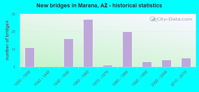
- New bridges - historical statistics
- 111930-1939
- 161950-1959
- 271960-1969
- 11970-1979
- 201980-1989
- 31990-1999
- 42000-2009
- 52010-2019

- Reconstructed bridges - Historical Statistics
- 91970-1979
- 01980-1989
- 71990-1999
- 82000-2009
- 22010-2019


- Bridge Condition - Deck
- 8.0%Very good
- 44.0%Good
- 40.0%Satisfactory
- 4.0%Fair
- 4.0%Poor

- Bridge Condition - Superstructure
- 20.0%Very good
- 48.0%Good
- 20.0%Satisfactory
- 12.0%Fair

- Bridge Condition - Substructure
- 12.0%Very good
- 76.0%Good
- 8.0%Satisfactory
- 4.0%Fair

- Bridge Condition - Channel
- 15.6%Very good
- 59.4%Good
- 18.8%Satisfactory
- 4.7%Fair
- 1.6%Poor

- Bridge Condition - Culverts
- 14.0%Very good
- 70.0%Good
- 16.0%Satisfactory
Find on map >> Show street view
Structure Number: 39, Location: 10.9 mi N Jct I-19 (Lat: 32.328900, Lng: -111.056900), Route carried "on" structure: Interstate 10, Year Built: 1953, Year Reconstructed: 1995, Status: Open, Structure Length: 10.45m (34.28ft), Average Daily Traffic: 40,744 (year 2018), Truck Traffic: 19%, Average Future Daily Traffic: 40,754 (year 2040), Design Load: HS 20, Features Intersected: Canada Del Oro Wash
Minimum Vertical Clearance: 30+ m (98+ ft), Kilometerpoint: 401.515, Lanes on structure: 3, Owner: State Highway Agency, Approaching Roadway Width: 17.7m (58.1ft), Material/Design: Concrete continuous, Design/Construction: Slab, Number Of Spans In Main Unit: 11, Length of Maximum Span: 9.8m (32.2ft), Curb-To-Curb Width: 17.7m (58.1ft), Out-to-Out Width: 18.7m (61.4ft)
Condition: Deck: Satisfactory, Superstructure: Satisfactory, Substructure: Good, Channel: Good, Operating Rating: 40.8 metric tons, Method Used To Determine Operating Rating: Load Factor (LF), Inventory Rating: 24.5 metric tons, Method Used To Determine Inventory Rating: Load Factor (LF), Structural Evaluation: Equal to present minimum criteria, Deck Geometry: Better than present minimum criteria, Waterway Adequacy: Better than present minimum criteria, Approach Roadway Alignment: Equal to present desirable criteria, Designated Inspection Frequency: Every 24 months, Inspection Date: October 2020, Deck Structure Type: Concrete Cast-file-Place, Wearing Surface/Protective System: Wearing Surface: Bituminous
Find on map >> Show street view
Structure Number: 391, Location: 9.7 mi N Jct I-19 (Lat: 32.315700, Lng: -111.046500), Route carried "on" structure: Interstate 10, Year Built: 1953, Year Reconstructed: 1996, Status: Open, Structure Length: 10.45m (34.28ft), Average Daily Traffic: 48,122 (year 2017), Truck Traffic: 19%, Average Future Daily Traffic: 48,132 (year 2037), Design Load: HS 20, Features Intersected: Rillito Creek
Minimum Vertical Clearance: 30+ m (98+ ft), Kilometerpoint: 403.398, Lanes on structure: 3, Owner: State Highway Agency, Approaching Roadway Width: 17.1m (56.1ft), Material/Design: Concrete continuous, Design/Construction: Slab, Number Of Spans In Main Unit: 11, Length of Maximum Span: 9.8m (32.2ft), Curb-To-Curb Width: 17.7m (58.1ft), Out-to-Out Width: 18.7m (61.4ft)
Condition: Deck: Satisfactory, Superstructure: Satisfactory, Substructure: Good, Channel: Good, Operating Rating: 39.9 metric tons, Method Used To Determine Operating Rating: Load Factor (LF), Inventory Rating: 23.6 metric tons, Method Used To Determine Inventory Rating: Load Factor (LF), Structural Evaluation: Somewhat better than minimum adequacy, Deck Geometry: Better than present minimum criteria, Waterway Adequacy: Equal to present minimum criteria, Approach Roadway Alignment: Equal to present desirable criteria, Designated Inspection Frequency: Every 24 months, Inspection Date: October 2020, Deck Structure Type: Concrete Cast-file-Place, Wearing Surface/Protective System: Wearing Surface: Bituminous
Find on map >> Show street view
Structure Number: 771, Location: 21.0 mi S Jct SR 84 (Lat: 32.506400, Lng: -111.269300), Route carried "on" structure: County highway , Year Built: 1963, Year Reconstructed: 2019, Status: Open, Structure Length: 7.56m (24.80ft), Average Daily Traffic: 1,250 (year 2020), Truck Traffic: 2%, Average Future Daily Traffic: 1,260 (year 2040), Design Load: HS 20, Features Intersected: I 10, Facility Carried by Structure: Pinal Air Park Rd
Minimum Vertical Clearance: 30+ m (98+ ft), Kilometerpoint: 0.000, Lanes on structure: 2, Lanes under structure: 7, Owner: State Highway Agency, Approaching Roadway Width: 9.8m (32.2ft), Material/Design: Steel continuous, Design/Construction: Stringer/Multi-beam, Number Of Spans In Main Unit: 4, Length of Maximum Span: 27.1m (88.9ft), Curb-To-Curb Width: 9.8m (32.2ft), Out-to-Out Width: 10.7m (35.1ft)
Condition: Deck: Very good, Superstructure: Good, Substructure: Good, Operating Rating: 49.0 metric tons, Method Used To Determine Operating Rating: Load Factor (LF), Inventory Rating: 29.0 metric tons, Method Used To Determine Inventory Rating: Load Factor (LF), Structural Evaluation: Better than present minimum criteria, Deck Geometry: Somewhat better than minimum adequacy, Underclear: High priority of corrective action, Approach Roadway Alignment: Equal to present desirable criteria, Designated Inspection Frequency: Every 24 months, Inspection Date: September 2020, Deck Structure Type: Concrete Cast-file-Place, Wearing Surface/Protective System: Wearing Surface: Monolithic Concrete
Find on map >> Show street view
Structure Number: 773, Location: 25.4 mi SE Jct SR 87 (Lat: 32.461900, Lng: -111.216800), Route carried "on" structure: Interstate 10, Year Built: 1963, Year Reconstructed: 2004, Status: Open, Structure Length: 3.87m (12.70ft), Average Daily Traffic: 22,988 (year 2018), Truck Traffic: 19%, Average Future Daily Traffic: 22,998 (year 2040), Design Load: HS 20+Mod, Features Intersected: Marana Road
Minimum Vertical Clearance: 30+ m (98+ ft), Kilometerpoint: 380.626, Lanes on structure: 3, Lanes under structure: 3, Owner: State Highway Agency, Approaching Roadway Width: 17.7m (58.1ft), Material/Design: Prestressed concrete, Design/Construction: Stringer/Multi-beam, Number Of Spans In Main Unit: 3, Length of Maximum Span: 19.2m (63.0ft), Curb-To-Curb Width: 17.7m (58.1ft), Out-to-Out Width: 18.9m (62.0ft)
Condition: Deck: Satisfactory, Superstructure: Satisfactory, Substructure: Good, Operating Rating: 62.6 metric tons, Method Used To Determine Operating Rating: Load Factor (LF), Inventory Rating: 39.9 metric tons, Method Used To Determine Inventory Rating: Load Factor (LF), Structural Evaluation: Equal to present minimum criteria, Deck Geometry: Better than present minimum criteria, Underclear: Equal to present minimum criteria, Approach Roadway Alignment: Equal to present desirable criteria, Designated Inspection Frequency: Every 24 months, Inspection Date: October 2020, Deck Structure Type: Concrete Cast-file-Place, Wearing Surface/Protective System: Wearing Surface: Bituminous
Find on map >> Show street view
Structure Number: 864, Location: 13.8 mi N Jct I-19 (Lat: 32.358900, Lng: -111.090100), Route carried "on" structure: Interstate 10, Year Built: 1966, Year Reconstructed: 2005, Status: Open, Structure Length: 3.87m (12.70ft), Average Daily Traffic: 43,952 (year 2018), Truck Traffic: 19%, Average Future Daily Traffic: 43,962 (year 2040), Design Load: HS 20, Features Intersected: FAS 317; Cortero Rd
Minimum Vertical Clearance: 30+ m (98+ ft), Kilometerpoint: 396.864, Lanes on structure: 3, Lanes under structure: 7, Owner: State Highway Agency, Approaching Roadway Width: 17.1m (56.1ft), Material/Design: Prestressed concrete, Design/Construction: Stringer/Multi-beam, Number Of Spans In Main Unit: 3, Length of Maximum Span: 19.2m (63.0ft), Curb-To-Curb Width: 18.0m (59.1ft), Out-to-Out Width: 18.9m (62.0ft)
Condition: Deck: Fair, Superstructure: Good, Substructure: Good, Operating Rating: 62.6 metric tons, Method Used To Determine Operating Rating: Load Factor (LF), Inventory Rating: 39.0 metric tons, Method Used To Determine Inventory Rating: Load Factor (LF), Structural Evaluation: Better than present minimum criteria, Deck Geometry: Better than present minimum criteria, Underclear: High priority of corrective action, Approach Roadway Alignment: Equal to present desirable criteria, Designated Inspection Frequency: Every 24 months, Inspection Date: October 2020, Deck Structure Type: Concrete Cast-file-Place, Wearing Surface/Protective System: Wearing Surface: Bituminous
Find on map >> Show street view
Structure Number: 865, Location: 13.8 mi N Jct I-19 (Lat: 32.359000, Lng: -111.089900), Route carried "on" structure: Interstate 10, Year Built: 1966, Year Reconstructed: 2005, Status: Open, Structure Length: 3.87m (12.70ft), Average Daily Traffic: 42,833 (year 2018), Truck Traffic: 19%, Average Future Daily Traffic: 42,843 (year 2040), Design Load: HS 20, Features Intersected: FAS 317; Cortero Rd
Minimum Vertical Clearance: 30+ m (98+ ft), Kilometerpoint: 396.864, Lanes on structure: 3, Lanes under structure: 7, Owner: State Highway Agency, Approaching Roadway Width: 17.1m (56.1ft), Material/Design: Prestressed concrete, Design/Construction: Stringer/Multi-beam, Number Of Spans In Main Unit: 3, Length of Maximum Span: 19.2m (63.0ft), Curb-To-Curb Width: 18.0m (59.1ft), Out-to-Out Width: 18.9m (62.0ft)
Condition: Deck: Satisfactory, Superstructure: Fair, Substructure: Good, Operating Rating: 62.6 metric tons, Method Used To Determine Operating Rating: Load Factor (LF), Inventory Rating: 39.0 metric tons, Method Used To Determine Inventory Rating: Load Factor (LF), Structural Evaluation: Somewhat better than minimum adequacy, Deck Geometry: Better than present minimum criteria, Underclear: High priority of corrective action, Approach Roadway Alignment: Equal to present desirable criteria, Designated Inspection Frequency: Every 24 months, Inspection Date: October 2020, Deck Structure Type: Concrete Cast-file-Place, Wearing Surface/Protective System: Wearing Surface: Bituminous
Find on map >> Show street view
Structure Number: 96, Location: 19.9 mi N Jct I-19 (Lat: 32.424400, Lng: -111.163800), Route carried "on" structure: Interstate 10, Year Built: 1967, Year Reconstructed: 2004, Status: Open, Structure Length: 3.87m (12.70ft), Average Daily Traffic: 30,300 (year 2018), Truck Traffic: 19%, Average Future Daily Traffic: 30,310 (year 2040), Design Load: HS 20+Mod, Features Intersected: FAS 483; Tangerine Rd
Minimum Vertical Clearance: 30+ m (98+ ft), Kilometerpoint: 386.967, Lanes on structure: 3, Lanes under structure: 4, Owner: State Highway Agency, Approaching Roadway Width: 17.1m (56.1ft), Material/Design: Prestressed concrete, Design/Construction: Stringer/Multi-beam, Number Of Spans In Main Unit: 3, Length of Maximum Span: 19.2m (63.0ft), Curb-To-Curb Width: 18.0m (59.1ft), Out-to-Out Width: 18.9m (62.0ft)
Condition: Deck: Good, Superstructure: Good, Substructure: Good, Operating Rating: 89.8 metric tons, Method Used To Determine Operating Rating: Load Factor (LF), Inventory Rating: 32.7 metric tons, Method Used To Determine Inventory Rating: Load Factor (LF), Structural Evaluation: Better than present minimum criteria, Deck Geometry: Better than present minimum criteria, Underclear: High priority of corrective action, Approach Roadway Alignment: Equal to present desirable criteria, Designated Inspection Frequency: Every 24 months, Inspection Date: October 2020, Deck Structure Type: Concrete Cast-file-Place, Wearing Surface/Protective System: Wearing Surface: Bituminous
Find on map >> Show street view
Structure Number: 961, Location: 19.9 mi N Jct I-19 (Lat: 32.424600, Lng: -111.163700), Route carried "on" structure: Interstate 10, Year Built: 1967, Year Reconstructed: 2004, Status: Open, Structure Length: 3.87m (12.70ft), Average Daily Traffic: 29,700 (year 2018), Truck Traffic: 19%, Average Future Daily Traffic: 29,710 (year 2040), Design Load: HS 20+Mod, Features Intersected: FAS 483; Tangerine Rd
Minimum Vertical Clearance: 30+ m (98+ ft), Kilometerpoint: 386.967, Lanes on structure: 3, Lanes under structure: 4, Owner: State Highway Agency, Approaching Roadway Width: 17.1m (56.1ft), Material/Design: Prestressed concrete, Design/Construction: Stringer/Multi-beam, Number Of Spans In Main Unit: 3, Length of Maximum Span: 19.2m (63.0ft), Curb-To-Curb Width: 18.0m (59.1ft), Out-to-Out Width: 18.9m (62.0ft)
Condition: Deck: Good, Superstructure: Satisfactory, Substructure: Good, Operating Rating: 89.8 metric tons, Method Used To Determine Operating Rating: Load Factor (LF), Inventory Rating: 32.7 metric tons, Method Used To Determine Inventory Rating: Load Factor (LF), Structural Evaluation: Equal to present minimum criteria, Deck Geometry: Better than present minimum criteria, Underclear: High priority of corrective action, Approach Roadway Alignment: Equal to present desirable criteria, Designated Inspection Frequency: Every 24 months, Inspection Date: October 2020, Deck Structure Type: Concrete Cast-file-Place, Wearing Surface/Protective System: Wearing Surface: Bituminous
Find on map >> Show street view
Structure Number: 973, Location: 18.3 mi North Jct I 19 (Lat: 32.409000, Lng: -111.142600), Route carried "on" structure: Interstate 10, Year Built: 1966, Year Reconstructed: 2005, Status: Open, Structure Length: 4.88m (16.01ft), Average Daily Traffic: 30,300 (year 2018), Truck Traffic: 15%, Average Future Daily Traffic: 30,310 (year 2040), Design Load: HS 20, Features Intersected: APC RR
Minimum Vertical Clearance: 30+ m (98+ ft), Kilometerpoint: 389.606, Lanes on structure: 3, Owner: State Highway Agency, Approaching Roadway Width: 18.0m (59.1ft), Skew: 4 degrees, Material/Design: Steel continuous, Design/Construction: Stringer/Multi-beam, Number Of Spans In Main Unit: 3, Length of Maximum Span: 17.7m (58.1ft), Curb-To-Curb Width: 18.0m (59.1ft), Out-to-Out Width: 18.9m (62.0ft)
Condition: Deck: Good, Superstructure: Good, Substructure: Satisfactory, Operating Rating: 54.4 metric tons, Method Used To Determine Operating Rating: Load Factor (LF), Inventory Rating: 32.7 metric tons, Method Used To Determine Inventory Rating: Load Factor (LF), Structural Evaluation: Equal to present minimum criteria, Deck Geometry: Better than present minimum criteria, Underclear: Somewhat better than minimum adequacy, Approach Roadway Alignment: Equal to present desirable criteria, Designated Inspection Frequency: Every 24 months, Inspection Date: September 2020, Deck Structure Type: Concrete Cast-file-Place, Wearing Surface/Protective System: Wearing Surface: Bituminous
Find on map >> Show street view
Structure Number: 976, Location: 17.4 mi N Jct I-19 (Lat: 32.401200, Lng: -111.131100), Route carried "on" structure: Interstate 10, Year Built: 1966, Year Reconstructed: 2004, Status: Open, Structure Length: 3.87m (12.70ft), Average Daily Traffic: 29,700 (year 2018), Truck Traffic: 19%, Average Future Daily Traffic: 29,710 (year 2040), Design Load: HS 20, Features Intersected: FAS 353; Avra Valley Rd
Minimum Vertical Clearance: 30+ m (98+ ft), Kilometerpoint: 390.990, Lanes on structure: 3, Lanes under structure: 2, Owner: State Highway Agency, Approaching Roadway Width: 18.0m (59.1ft), Material/Design: Prestressed concrete, Design/Construction: Stringer/Multi-beam, Number Of Spans In Main Unit: 3, Length of Maximum Span: 19.2m (63.0ft), Curb-To-Curb Width: 18.0m (59.1ft), Out-to-Out Width: 18.9m (62.0ft)
Condition: Deck: Good, Superstructure: Good, Substructure: Good, Operating Rating: 62.6 metric tons, Method Used To Determine Operating Rating: Load Factor (LF), Inventory Rating: 39.0 metric tons, Method Used To Determine Inventory Rating: Load Factor (LF), Structural Evaluation: Better than present minimum criteria, Deck Geometry: Better than present minimum criteria, Underclear: Meets minimum limits, Approach Roadway Alignment: Equal to present desirable criteria, Designated Inspection Frequency: Every 24 months, Inspection Date: October 2020, Deck Structure Type: Concrete Cast-file-Place, Wearing Surface/Protective System: Wearing Surface: Bituminous
Find on map >> Show street view
Structure Number: 1397, Location: 9.7 mi N Jct I-19 (Lat: 32.315500, Lng: -111.046900), Route carried "on" structure: ServiceState highway 10, Year Built: 2001, Status: Open, Structure Length: 10.52m (34.51ft), Average Daily Traffic: 510 (year 2018), Truck Traffic: 5%, Average Future Daily Traffic: 520 (year 2038), Design Load: HS 20, Features Intersected: Rillito Creek, Facility Carried by Structure: EB Frontage Road
Minimum Vertical Clearance: 30+ m (98+ ft), Kilometerpoint: 403.398, Lanes on structure: 2, Owner: State Highway Agency, Approaching Roadway Width: 13.4m (44.0ft), Material/Design: Prestressed concrete continuous, Design/Construction: Stringer/Multi-beam, Number Of Spans In Main Unit: 4, Length of Maximum Span: 26.2m (86.0ft), Curb-To-Curb Width: 13.4m (44.0ft), Out-to-Out Width: 14.3m (46.9ft)
Condition: Deck: Satisfactory, Superstructure: Good, Substructure: Good, Channel: Good, Operating Rating: 88.0 metric tons, Method Used To Determine Operating Rating: Load Factor (LF), Inventory Rating: 38.1 metric tons, Method Used To Determine Inventory Rating: Load Factor (LF), Structural Evaluation: Better than present minimum criteria, Deck Geometry: Superior to present desirable criteria, Waterway Adequacy: Better than present minimum criteria, Approach Roadway Alignment: Equal to present desirable criteria, Designated Inspection Frequency: Every 24 months, Inspection Date: October 2020, Deck Structure Type: Concrete Cast-file-Place, Wearing Surface/Protective System: Wearing Surface: Monolithic Concrete
Find on map >> Show street view
Structure Number: 1398, Location: 9.7 mi N Jct I-19 (Lat: 32.315900, Lng: -111.046000), Route carried "on" structure: ServiceState highway 10, Year Built: 2001, Status: Open, Structure Length: 10.52m (34.51ft), Average Daily Traffic: 510 (year 2018), Truck Traffic: 5%, Average Future Daily Traffic: 520 (year 2038), Design Load: HS 20, Features Intersected: Rillito Creek, Facility Carried by Structure: WB Frontage Road
Minimum Vertical Clearance: 30+ m (98+ ft), Kilometerpoint: 403.398, Lanes on structure: 2, Owner: State Highway Agency, Approaching Roadway Width: 13.4m (44.0ft), Material/Design: Prestressed concrete continuous, Design/Construction: Stringer/Multi-beam, Number Of Spans In Main Unit: 4, Length of Maximum Span: 26.2m (86.0ft), Curb-To-Curb Width: 13.4m (44.0ft), Out-to-Out Width: 14.3m (46.9ft)
Condition: Deck: Satisfactory, Superstructure: Good, Substructure: Good, Channel: Good, Operating Rating: 88.0 metric tons, Method Used To Determine Operating Rating: Load Factor (LF), Inventory Rating: 38.1 metric tons, Method Used To Determine Inventory Rating: Load Factor (LF), Structural Evaluation: Better than present minimum criteria, Deck Geometry: Superior to present desirable criteria, Waterway Adequacy: Better than present minimum criteria, Approach Roadway Alignment: Equal to present desirable criteria, Designated Inspection Frequency: Every 24 months, Inspection Date: October 2020, Deck Structure Type: Concrete Cast-file-Place, Wearing Surface/Protective System: Wearing Surface: Monolithic Concrete
Find on map >> Show street view
Structure Number: 1432, Location: 10.9 mi N Jct I-19 (Lat: 32.329100, Lng: -111.056700), Route carried "on" structure: ServiceState highway 10, Year Built: 1999, Status: Open, Structure Length: 10.52m (34.51ft), Average Daily Traffic: 550 (year 2020), Truck Traffic: 2%, Average Future Daily Traffic: 560 (year 2040), Design Load: HS 20, Features Intersected: Canada Del Oro Wash, Facility Carried by Structure: WB Frontage Road
Minimum Vertical Clearance: 30+ m (98+ ft), Kilometerpoint: 401.644, Lanes on structure: 2, Owner: State Highway Agency, Approaching Roadway Width: 13.4m (44.0ft), Material/Design: Prestressed concrete continuous, Design/Construction: Stringer/Multi-beam, Number Of Spans In Main Unit: 4, Length of Maximum Span: 26.2m (86.0ft), Curb-To-Curb Width: 13.4m (44.0ft), Out-to-Out Width: 14.3m (46.9ft)
Condition: Deck: Satisfactory, Superstructure: Good, Substructure: Good, Channel: Good, Operating Rating: 89.8 metric tons, Method Used To Determine Operating Rating: Load Factor (LF), Inventory Rating: 41.7 metric tons, Method Used To Determine Inventory Rating: Load Factor (LF), Structural Evaluation: Better than present minimum criteria, Deck Geometry: High priority of corrective action, Waterway Adequacy: Better than present minimum criteria, Approach Roadway Alignment: Equal to present desirable criteria, Designated Inspection Frequency: Every 24 months, Inspection Date: October 2020, Deck Structure Type: Concrete Cast-file-Place, Wearing Surface/Protective System: Wearing Surface: Monolithic Concrete
Find on map >> Show street view
Structure Number: 252, Location: 22.2 mi NW Jct SR 71 (Lat: 34.368800, Lng: -113.184200), Route carried "on" structure: US 93, Year Built: 2000, Status: Open, Structure Length: 23.74m (77.89ft), Average Daily Traffic: 3,346 (year 2017), Truck Traffic: 15%, Average Future Daily Traffic: 3,356 (year 2038), Design Load: HS 20, Features Intersected: Santa Maria River
Minimum Vertical Clearance: 30+ m (98+ ft), Kilometerpoint: 258.573, Lanes on structure: 2, Owner: State Highway Agency, Approaching Roadway Width: 11.6m (38.1ft), Material/Design: Prestressed concrete continuous, Design/Construction: Stringer/Multi-beam, Number Of Spans In Main Unit: 6, Length of Maximum Span: 39.3m (128.9ft), Curb-To-Curb Width: 13.0m (42.7ft), Out-to-Out Width: 13.7m (44.9ft)
Condition: Deck: Satisfactory, Superstructure: Very good, Substructure: Good, Channel: Good, Operating Rating: 81.6 metric tons, Method Used To Determine Operating Rating: Load Factor (LF), Inventory Rating: 39.9 metric tons, Method Used To Determine Inventory Rating: Load Factor (LF), Structural Evaluation: Better than present minimum criteria, Deck Geometry: Superior to present desirable criteria, Waterway Adequacy: Equal to present desirable criteria, Approach Roadway Alignment: Equal to present desirable criteria, Designated Inspection Frequency: Every 24 months, Inspection Date: December 2020, Deck Structure Type: Concrete Cast-file-Place, Wearing Surface/Protective System: Wearing Surface: Monolithic Concrete
Find on map >> Show street view
Structure Number: 2522, Location: 0.3 mi E of Price (Lat: 33.356500, Lng: -111.894400), Route carried "on" structure: City street , Year Built: 1999, Status: Open, Structure Length: 6.46m (21.19ft), Average Future Daily Traffic: 10 (year 2040), Design Load: HS 20, Features Intersected: SR 101L, Facility Carried by Structure: Lateral 9.5 Canal
Minimum Vertical Clearance: 30+ m (98+ ft), Kilometerpoint: 0.000, Lanes on structure: 2, Lanes under structure: 10, Owner: State Highway Agency, Approaching Roadway Width: 7.3m (24.0ft), Material/Design: Prestressed concrete continuous, Design/Construction: Box Beam or Girders - Single/Spread, Number Of Spans In Main Unit: 2, Length of Maximum Span: 31.4m (103.0ft), Curb-To-Curb Width: 7.3m (24.0ft), Out-to-Out Width: 8.0m (26.2ft)
Condition: Deck: Good, Superstructure: Fair, Substructure: Good, Operating Rating: 89.8 metric tons, Method Used To Determine Operating Rating: Load Factor (LF), Inventory Rating: 45.4 metric tons, Method Used To Determine Inventory Rating: Load Factor (LF), Structural Evaluation: Somewhat better than minimum adequacy, Deck Geometry: Equal to present minimum criteria, Underclear: Meets minimum limits, Approach Roadway Alignment: Equal to present desirable criteria, Designated Inspection Frequency: Every 24 months, Inspection Date: December 2020, Deck Structure Type: Concrete Cast-file-Place, Wearing Surface/Protective System: Wearing Surface: Monolithic Concrete
Find on map >> Show street view
Structure Number: 289, Location: 10.3 mi NW Jct SR 77 (Lat: 32.378800, Lng: -111.109900), Route carried "on" structure: City street , Year Built: 2010, Status: Open, Structure Length: 6.64m (21.78ft), Average Daily Traffic: 20,000 (year 2020), Truck Traffic: 5%, Average Future Daily Traffic: 20,010 (year 2040), Design Load: HS 20, Features Intersected: I-10, Facility Carried by Structure: Twin Peaks Rd.
Minimum Vertical Clearance: 9.14m (29.99ft), Kilometerpoint: 0.000, Lanes on structure: 10, Lanes under structure: 6, Owner: State Highway Agency, Approaching Roadway Width: 42.1m (138.1ft), Skew: 20 degrees, Material/Design: Prestressed concrete, Design/Construction: Stringer/Multi-beam, Number Of Spans In Main Unit: 2, Length of Maximum Span: 32.3m (106.0ft), Curb or Sidewalk Widths: Left: 1.8m (5.9ft), Right: 1.8m (5.9ft), Curb-To-Curb Width: 43.3m (142.1ft), Out-to-Out Width: 47.5m (155.8ft)
Condition: Deck: Very good, Superstructure: Very good, Substructure: Very good, Operating Rating: 89.8 metric tons, Method Used To Determine Operating Rating: Load Factor (LF), Inventory Rating: 41.7 metric tons, Method Used To Determine Inventory Rating: Load Factor (LF), Structural Evaluation: Equal to present desirable criteria, Deck Geometry: Superior to present desirable criteria, Underclear: Equal to present minimum criteria, Approach Roadway Alignment: Equal to present desirable criteria, Designated Inspection Frequency: Every 24 months, Inspection Date: October 2020, Deck Structure Type: Concrete Cast-file-Place, Wearing Surface/Protective System: Wearing Surface: Monolithic Concrete
Find on map >> Show street view
Structure Number: 2891, Location: 10.3 mi NW Jct SR 77 (Lat: 32.379300, Lng: -111.109000), Route carried "on" structure: Ramp State highway 10, Year Built: 2010, Status: Open, Structure Length: 6.95m (22.80ft), Average Daily Traffic: 20,000 (year 2020), Truck Traffic: 5%, Average Future Daily Traffic: 20,010 (year 2040), Design Load: HS 20, Features Intersected: UPRR, Facility Carried by Structure: Twin Peak Rd.
Minimum Vertical Clearance: 10.67m (35.01ft), Kilometerpoint: 0.000, Lanes on structure: 9, Owner: State Highway Agency, Approaching Roadway Width: 42.1m (138.1ft), Skew: 20 degrees, Material/Design: Prestressed concrete continuous, Design/Construction: Box Beam or Girders - Multiple, Number Of Spans In Main Unit: 3, Length of Maximum Span: 23.2m (76.1ft), Curb or Sidewalk Widths: Left: 1.8m (5.9ft), Right: 1.8m (5.9ft), Curb-To-Curb Width: 43.6m (143.0ft), Out-to-Out Width: 47.9m (157.2ft)
Condition: Deck: Good, Superstructure: Very good, Substructure: Very good, Operating Rating: 89.8 metric tons, Method Used To Determine Operating Rating: Load Factor (LF), Inventory Rating: 75.3 metric tons, Method Used To Determine Inventory Rating: Load Factor (LF), Structural Evaluation: Equal to present desirable criteria, Deck Geometry: Superior to present desirable criteria, Underclear: Superior to present desirable criteria, Waterway Adequacy: Equal to present desirable criteria, Approach Roadway Alignment: Equal to present desirable criteria, Designated Inspection Frequency: Every 24 months, Inspection Date: October 2020, Deck Structure Type: Concrete Cast-file-Place, Wearing Surface/Protective System: Wearing Surface: Monolithic Concrete
Find on map >> Show street view
Structure Number: 5518, Location: 19.8 mi South Jct SR 84 (Lat: 32.522000, Lng: -111.280000), Route carried "on" structure: Interstate 10, Year Built: 1954, Year Reconstructed: 2008, Status: Open, Structure Length: 0.98m (3.22ft), Average Daily Traffic: 45,445 (year 2017), Truck Traffic: 19%, Average Future Daily Traffic: 45,455 (year 2038), Design Load: HS 20, Features Intersected: Wash
Minimum Vertical Clearance: 30+ m (98+ ft), Kilometerpoint: 371.581, Lanes on structure: 6, Owner: State Highway Agency, Approaching Roadway Width: 36.6m (120.1ft), Skew: 30 degrees, Material/Design: Concrete continuous, Design/Construction: Culvert, Number Of Spans In Main Unit: 3, Length of Maximum Span: 3.0m (9.8ft)
Condition: Channel: Good, Culverts: Very good, Operating Rating: 89.8 metric tons, Method Used To Determine Operating Rating: Load Factor (LF), Inventory Rating: 78.0 metric tons, Method Used To Determine Inventory Rating: Load Factor (LF), Structural Evaluation: Equal to present desirable criteria, Waterway Adequacy: Equal to present desirable criteria, Approach Roadway Alignment: Equal to present desirable criteria, Length Of Structure Improvement: 1.74m (5.71ft), Designated Inspection Frequency: Every 48 months, Inspection Date: September 2018, Roadway Improvement Cost: $1,000, Total Project Cost: $2,000
Find on map >> Show street view
Structure Number: 552, Location: 20.0 mi South Jct SR 84 (Lat: 32.519700, Lng: -111.278100), Route carried "on" structure: Interstate 10, Year Built: 1954, Year Reconstructed: 2008, Status: Open, Structure Length: 0.64m (2.10ft), Average Daily Traffic: 45,445 (year 2017), Truck Traffic: 19%, Average Future Daily Traffic: 45,455 (year 2038), Design Load: HS 20, Features Intersected: Wash
Minimum Vertical Clearance: 30+ m (98+ ft), Kilometerpoint: 371.839, Lanes on structure: 6, Owner: State Highway Agency, Approaching Roadway Width: 36.6m (120.1ft), Skew: 30 degrees, Material/Design: Concrete continuous, Design/Construction: Culvert, Number Of Spans In Main Unit: 2, Length of Maximum Span: 3.0m (9.8ft)
Condition: Channel: Good, Culverts: Good, Operating Rating: 89.8 metric tons, Method Used To Determine Operating Rating: Load Factor (LF), Inventory Rating: 76.2 metric tons, Method Used To Determine Inventory Rating: Load Factor (LF), Structural Evaluation: Better than present minimum criteria, Waterway Adequacy: Equal to present desirable criteria, Approach Roadway Alignment: Equal to present desirable criteria, Length Of Structure Improvement: 1.37m (4.49ft), Designated Inspection Frequency: Every 48 months, Inspection Date: September 2018, Bridge Improvement Cost: $1,000, Roadway Improvement Cost: $1,000, Total Project Cost: $2,000 ( Estimate for 2014)
Find on map >> Show street view
Structure Number: 5522, Location: 20.6 mi South Jct 84 (Lat: 32.512600, Lng: -111.272300), Route carried "on" structure: Interstate 10, Year Built: 1954, Year Reconstructed: 1979, Status: Open, Structure Length: 0.64m (2.10ft), Average Daily Traffic: 45,445 (year 2017), Truck Traffic: 19%, Average Future Daily Traffic: 45,455 (year 2038), Design Load: HS 20, Features Intersected: Wash
Minimum Vertical Clearance: 30+ m (98+ ft), Kilometerpoint: 372.788, Lanes on structure: 6, Owner: State Highway Agency, Approaching Roadway Width: 36.6m (120.1ft), Skew: 30 degrees, Material/Design: Concrete continuous, Design/Construction: Culvert, Number Of Spans In Main Unit: 2, Length of Maximum Span: 3.0m (9.8ft)
Condition: Channel: Good, Culverts: Good, Operating Rating: 89.8 metric tons, Method Used To Determine Operating Rating: Load Factor (LF), Inventory Rating: 76.2 metric tons, Method Used To Determine Inventory Rating: Load Factor (LF), Structural Evaluation: Better than present minimum criteria, Waterway Adequacy: Equal to present desirable criteria, Approach Roadway Alignment: Equal to present desirable criteria, Length Of Structure Improvement: 1.37m (4.49ft), Designated Inspection Frequency: Every 48 months, Inspection Date: September 2018, Bridge Improvement Cost: $1,000, Roadway Improvement Cost: $1,000, Total Project Cost: $2,000 ( Estimate for 2014)
Find on map >> Show street view
Structure Number: 5524, Location: 21.8 mi South Jct SR 84 (Lat: 32.496400, Lng: -111.263300), Route carried "on" structure: Interstate 10, Year Built: 1963, Year Reconstructed: 2008, Status: Open, Structure Length: 3.96m (12.99ft), Average Daily Traffic: 45,834 (year 2017), Truck Traffic: 19%, Average Future Daily Traffic: 45,844 (year 2038), Design Load: HS 20, Features Intersected: Wash
Minimum Vertical Clearance: 30+ m (98+ ft), Kilometerpoint: 374.800, Lanes on structure: 6, Owner: State Highway Agency, Approaching Roadway Width: 34.1m (111.9ft), Skew: 36 degrees, Material/Design: Concrete continuous, Design/Construction: Culvert, Number Of Spans In Main Unit: 6, Length of Maximum Span: 6.1m (20.0ft)
Condition: Channel: Poor, Culverts: Good, Operating Rating: 89.8 metric tons, Method Used To Determine Operating Rating: Load Factor (LF), Inventory Rating: 77.1 metric tons, Method Used To Determine Inventory Rating: Load Factor (LF), Structural Evaluation: Better than present minimum criteria, Waterway Adequacy: Equal to present minimum criteria, Approach Roadway Alignment: Equal to present desirable criteria, Length Of Structure Improvement: 4.82m (15.81ft), Designated Inspection Frequency: Every 48 months, Inspection Date: September 2018, Bridge Improvement Cost: $1,000, Roadway Improvement Cost: $1,000, Total Project Cost: $3,000 ( Estimate for 2014), Deck Structure Type: Concrete Cast-file-Place, Wearing Surface/Protective System: Wearing Surface: Bituminous
Find on map >> Show street view
Structure Number: 5526, Location: 23.5 mi South Jct SR 84 (Lat: 32.480400, Lng: -111.242200), Route carried "on" structure: Interstate 10, Year Built: 1951, Year Reconstructed: 1979, Status: Open, Structure Length: 1.31m (4.30ft), Average Daily Traffic: 46,000 (year 2012), Truck Traffic: 19%, Average Future Daily Traffic: 46,010 (year 2030), Design Load: HS 20, Features Intersected: Wash
Minimum Vertical Clearance: 30+ m (98+ ft), Kilometerpoint: 377.456, Lanes on structure: 6, Owner: State Highway Agency, Approaching Roadway Width: 34.1m (111.9ft), Skew: 30 degrees, Material/Design: Concrete continuous, Design/Construction: Culvert, Number Of Spans In Main Unit: 4, Length of Maximum Span: 3.0m (9.8ft)
Condition: Channel: Good, Culverts: Good, Operating Rating: 65.3 metric tons, Method Used To Determine Operating Rating: Load Factor (LF), Inventory Rating: 39.0 metric tons, Method Used To Determine Inventory Rating: Load Factor (LF), Structural Evaluation: Better than present minimum criteria, Waterway Adequacy: Better than present minimum criteria, Approach Roadway Alignment: Equal to present desirable criteria, Length Of Structure Improvement: 2.07m (6.79ft), Designated Inspection Frequency: Every 48 months, Inspection Date: September 2018, Bridge Improvement Cost: $1,000, Roadway Improvement Cost: $1,000, Total Project Cost: $2,000 ( Estimate for 2014)
Find on map >> Show street view
Structure Number: 5528, Location: 23.6 mi South Jct SR 84 (Lat: 32.478700, Lng: -111.239800), Route carried "on" structure: Interstate 10, Year Built: 1951, Year Reconstructed: 1979, Status: Open, Structure Length: 1.31m (4.30ft), Average Daily Traffic: 42,000 (year 2012), Truck Traffic: 19%, Average Future Daily Traffic: 42,010 (year 2030), Design Load: HS 20, Features Intersected: Wash
Minimum Vertical Clearance: 30+ m (98+ ft), Kilometerpoint: 377.729, Lanes on structure: 6, Owner: State Highway Agency, Approaching Roadway Width: 36.6m (120.1ft), Skew: 30 degrees, Material/Design: Concrete continuous, Design/Construction: Culvert, Number Of Spans In Main Unit: 4, Length of Maximum Span: 3.0m (9.8ft)
Condition: Channel: Good, Culverts: Very good, Operating Rating: 65.3 metric tons, Method Used To Determine Operating Rating: Load Factor (LF), Inventory Rating: 39.0 metric tons, Method Used To Determine Inventory Rating: Load Factor (LF), Structural Evaluation: Equal to present desirable criteria, Waterway Adequacy: Better than present minimum criteria, Approach Roadway Alignment: Equal to present desirable criteria, Length Of Structure Improvement: 2.07m (6.79ft), Designated Inspection Frequency: Every 48 months, Inspection Date: September 2018, Bridge Improvement Cost: $1,000, Roadway Improvement Cost: $1,000, Total Project Cost: $2,000 ( Estimate for 2014)
Find on map >> Show street view
Structure Number: 5532, Location: 22.9 mi North Jct I 19 (Lat: 32.451700, Lng: -111.201700), Route carried "on" structure: Interstate 10, Year Built: 1951, Year Reconstructed: 1979, Status: Open, Structure Length: 1.31m (4.30ft), Average Daily Traffic: 60,910 (year 2017), Truck Traffic: 16%, Average Future Daily Traffic: 60,920 (year 2038), Design Load: HS 20, Features Intersected: Wash
Minimum Vertical Clearance: 30+ m (98+ ft), Kilometerpoint: 382.445, Lanes on structure: 6, Owner: State Highway Agency, Approaching Roadway Width: 36.6m (120.1ft), Skew: 30 degrees, Material/Design: Concrete continuous, Design/Construction: Culvert, Number Of Spans In Main Unit: 4, Length of Maximum Span: 3.0m (9.8ft)
Condition: Channel: Very good, Culverts: Good, Operating Rating: 63.5 metric tons, Method Used To Determine Operating Rating: Load Factor (LF), Inventory Rating: 38.1 metric tons, Method Used To Determine Inventory Rating: Load Factor (LF), Structural Evaluation: Better than present minimum criteria, Waterway Adequacy: Equal to present desirable criteria, Approach Roadway Alignment: Equal to present desirable criteria, Length Of Structure Improvement: 1.31m (4.30ft), Designated Inspection Frequency: Every 48 months, Inspection Date: September 2018, Bridge Improvement Cost: $1,000, Total Project Cost: $1,000 ( Estimate for 2014)
Find on map >> Show street view
Structure Number: 5534, Location: 22.7 mi North Jct I 19 (Lat: 32.452778, Lng: -111.208333), Route carried "on" structure: Interstate 10, Year Built: 1951, Year Reconstructed: 1979, Status: Open, Structure Length: 1.95m (6.40ft), Average Daily Traffic: 63,187 (year 2019), Truck Traffic: 14%, Average Future Daily Traffic: 63,197 (year 2039), Design Load: HS 20, Features Intersected: Wash
Minimum Vertical Clearance: 30+ m (98+ ft), Kilometerpoint: 382.589, Lanes on structure: 6, Owner: State Highway Agency, Approaching Roadway Width: 34.1m (111.9ft), Skew: 20 degrees, Material/Design: Concrete continuous, Design/Construction: Culvert, Number Of Spans In Main Unit: 6, Length of Maximum Span: 3.0m (9.8ft)
Condition: Channel: Good, Culverts: Good, Operating Rating: 63.5 metric tons, Method Used To Determine Operating Rating: Load Factor (LF), Inventory Rating: 38.1 metric tons, Method Used To Determine Inventory Rating: Load Factor (LF), Structural Evaluation: Better than present minimum criteria, Waterway Adequacy: Better than present minimum criteria, Approach Roadway Alignment: Equal to present desirable criteria, Length Of Structure Improvement: 1.95m (6.40ft), Designated Inspection Frequency: Every 48 months, Inspection Date: September 2020, Roadway Improvement Cost: $1,000, Total Project Cost: $2,000 ( Estimate for 2020)
Find on map >> Show street view
Structure Number: 5536, Location: 22.5 mi North Jct I 19 (Lat: 32.458333, Lng: -111.205556), Route carried "on" structure: Interstate 10, Year Built: 1951, Year Reconstructed: 1979, Status: Open, Structure Length: 0.98m (3.22ft), Average Daily Traffic: 63,187 (year 2019), Truck Traffic: 14%, Average Future Daily Traffic: 63,197 (year 2039), Design Load: HS 20, Features Intersected: Wash
Minimum Vertical Clearance: 30+ m (98+ ft), Kilometerpoint: 382.831, Lanes on structure: 6, Owner: State Highway Agency, Approaching Roadway Width: 19.2m (63.0ft), Skew: 30 degrees, Material/Design: Concrete continuous, Design/Construction: Culvert, Number Of Spans In Main Unit: 3, Length of Maximum Span: 3.0m (9.8ft)
Condition: Channel: Good, Culverts: Good, Operating Rating: 63.5 metric tons, Method Used To Determine Operating Rating: Load Factor (LF), Inventory Rating: 38.1 metric tons, Method Used To Determine Inventory Rating: Load Factor (LF), Structural Evaluation: Better than present minimum criteria, Waterway Adequacy: Equal to present desirable criteria, Approach Roadway Alignment: Equal to present desirable criteria, Length Of Structure Improvement: 0.98m (3.22ft), Designated Inspection Frequency: Every 48 months, Inspection Date: September 2020, Total Project Cost: $1,000 ( Estimate for 2020)
Find on map >> Show street view
Structure Number: 5538, Location: 22.4 mi North Jct I 19 (Lat: 32.458333, Lng: -111.202778), Route carried "on" structure: Interstate 10, Year Built: 1963, Year Reconstructed: 1979, Status: Open, Structure Length: 1.95m (6.40ft), Average Daily Traffic: 63,187 (year 2019), Truck Traffic: 14%, Average Future Daily Traffic: 63,197 (year 2039), Design Load: HS 20, Features Intersected: Wash
Minimum Vertical Clearance: 30+ m (98+ ft), Kilometerpoint: 383.072, Lanes on structure: 6, Owner: State Highway Agency, Approaching Roadway Width: 19.2m (63.0ft), Skew: 30 degrees, Material/Design: Concrete continuous, Design/Construction: Culvert, Number Of Spans In Main Unit: 6, Length of Maximum Span: 3.0m (9.8ft)
Condition: Channel: Good, Culverts: Good, Operating Rating: 63.5 metric tons, Method Used To Determine Operating Rating: Load Factor (LF), Inventory Rating: 38.1 metric tons, Method Used To Determine Inventory Rating: Load Factor (LF), Structural Evaluation: Better than present minimum criteria, Waterway Adequacy: Equal to present desirable criteria, Approach Roadway Alignment: Equal to present desirable criteria, Length Of Structure Improvement: 1.95m (6.40ft), Designated Inspection Frequency: Every 48 months, Inspection Date: September 2020, Bridge Improvement Cost: $1,000, Total Project Cost: $1,000 ( Estimate for 2020)
Find on map >> Show street view
Structure Number: 554, Location: 22.1 mi North Jct I 19 (Lat: 32.444444, Lng: -111.191667), Route carried "on" structure: Interstate 10, Year Built: 1951, Year Reconstructed: 1979, Status: Open, Structure Length: 1.31m (4.30ft), Average Daily Traffic: 63,187 (year 2019), Truck Traffic: 9%, Average Future Daily Traffic: 63,197 (year 2039), Design Load: HS 20, Features Intersected: Wash
Minimum Vertical Clearance: 30+ m (98+ ft), Kilometerpoint: 383.442, Lanes on structure: 6, Owner: State Highway Agency, Approaching Roadway Width: 19.2m (63.0ft), Skew: 30 degrees, Material/Design: Concrete continuous, Design/Construction: Culvert, Number Of Spans In Main Unit: 4, Length of Maximum Span: 3.0m (9.8ft)
Condition: Channel: Very good, Culverts: Good, Operating Rating: 65.3 metric tons, Method Used To Determine Operating Rating: Load Factor (LF), Inventory Rating: 39.0 metric tons, Method Used To Determine Inventory Rating: Load Factor (LF), Structural Evaluation: Better than present minimum criteria, Waterway Adequacy: Better than present minimum criteria, Approach Roadway Alignment: Equal to present desirable criteria, Length Of Structure Improvement: 2.07m (6.79ft), Designated Inspection Frequency: Every 48 months, Inspection Date: September 2020, Roadway Improvement Cost: $1,000, Total Project Cost: $2,000 ( Estimate for 2020)
Find on map >> Show street view
Structure Number: 5542, Location: 18.0 mi North Jct I 19 (Lat: 32.411111, Lng: -111.141667), Route carried "on" structure: ServiceState highway 10, Year Built: 1931, Status: Open, Structure Length: 0.64m (2.10ft), Average Daily Traffic: 120 (year 2019), Truck Traffic: 20%, Average Future Daily Traffic: 130 (year 2039), Design Load: HS 20, Features Intersected: Wash
Minimum Vertical Clearance: 30+ m (98+ ft), Kilometerpoint: 390.025, Lanes on structure: 1, Owner: State Highway Agency, Approaching Roadway Width: 9.8m (32.2ft), Material/Design: Concrete continuous, Design/Construction: Culvert, Number Of Spans In Main Unit: 2, Length of Maximum Span: 3.0m (9.8ft), Curb or Sidewalk Widths: Left: 0.2m (0.7ft), Right: 0.2m (0.7ft), Curb-To-Curb Width: 9.8m (32.2ft), Out-to-Out Width: 10.2m (33.5ft)
Condition: Channel: Satisfactory, Culverts: Good, Operating Rating: 52.6 metric tons, Method Used To Determine Operating Rating: Load Factor (LF), Inventory Rating: 31.8 metric tons, Method Used To Determine Inventory Rating: Load Factor (LF), Structural Evaluation: Better than present minimum criteria, Deck Geometry: Better than present minimum criteria, Waterway Adequacy: Better than present minimum criteria, Approach Roadway Alignment: Equal to present desirable criteria, Designated Inspection Frequency: Every 48 months, Inspection Date: September 2020, Deck Structure Type: Concrete Cast-file-Place, Wearing Surface/Protective System: Wearing Surface: Bituminous
Find on map >> Show street view
Structure Number: 5543, Location: 16.4 mi North Jct I 19 (Lat: 32.388889, Lng: -111.119444), Route carried "on" structure: Interstate 10, Year Built: 1967, Status: Open, Structure Length: 1.98m (6.50ft), Average Daily Traffic: 86,785 (year 2018), Truck Traffic: 14%, Average Future Daily Traffic: 86,795 (year 2040), Design Load: HS 20, Features Intersected: Wash
Minimum Vertical Clearance: 30+ m (98+ ft), Kilometerpoint: 392.616, Lanes on structure: 6, Owner: State Highway Agency, Approaching Roadway Width: 17.7m (58.1ft), Skew: 34 degrees, Material/Design: Concrete continuous, Design/Construction: Culvert, Number Of Spans In Main Unit: 6, Length of Maximum Span: 3.0m (9.8ft)
Condition: Channel: Satisfactory, Culverts: Very good, Operating Rating: 63.5 metric tons, Method Used To Determine Operating Rating: Load Factor (LF), Inventory Rating: 38.1 metric tons, Method Used To Determine Inventory Rating: Load Factor (LF), Structural Evaluation: Equal to present desirable criteria, Waterway Adequacy: Equal to present minimum criteria, Approach Roadway Alignment: Equal to present desirable criteria, Length Of Structure Improvement: 2.77m (9.09ft), Designated Inspection Frequency: Every 48 months, Inspection Date: September 2020, Bridge Improvement Cost: $1,000, Roadway Improvement Cost: $1,000, Total Project Cost: $2,000 ( Estimate for 2020)
Find on map >> Show street view
Structure Number: 5545, Location: 12.8 mi North Jct I 19 (Lat: 32.350000, Lng: -111.088889), Route carried "on" structure: Interstate 10, Year Built: 1953, Year Reconstructed: 1979, Status: Open, Structure Length: 0.98m (3.22ft), Average Daily Traffic: 86,785 (year 2018), Truck Traffic: 14%, Average Future Daily Traffic: 86,795 (year 2040), Design Load: HS 20, Features Intersected: Wash
Minimum Vertical Clearance: 30+ m (98+ ft), Kilometerpoint: 398.522, Lanes on structure: 8, Owner: State Highway Agency, Approaching Roadway Width: 17.1m (56.1ft), Skew: 30 degrees, Material/Design: Concrete continuous, Design/Construction: Culvert, Number Of Spans In Main Unit: 3, Length of Maximum Span: 3.0m (9.8ft)
Condition: Channel: Good, Culverts: Good, Operating Rating: 65.3 metric tons, Method Used To Determine Operating Rating: Load Factor (LF), Inventory Rating: 39.0 metric tons, Method Used To Determine Inventory Rating: Load Factor (LF), Structural Evaluation: Better than present minimum criteria, Waterway Adequacy: Better than present minimum criteria, Approach Roadway Alignment: Equal to present desirable criteria, Length Of Structure Improvement: 1.74m (5.71ft), Designated Inspection Frequency: Every 48 months, Inspection Date: September 2020, Bridge Improvement Cost: $1,000, Roadway Improvement Cost: $1,000, Total Project Cost: $2,000 ( Estimate for 2014)
Find on map >> Show street view
Structure Number: 5894, Location: 9.9 mi W Jct US 89 (Lat: 35.236900, Lng: -112.645100), Route carried "on" structure: Interstate 40, Year Built: 1966, Status: Open, Structure Length: 0.76m (2.49ft), Average Daily Traffic: 7,956 (year 2017), Truck Traffic: 40%, Average Future Daily Traffic: 7,966 (year 2038), Design Load: HS 20, Features Intersected: Wash
Minimum Vertical Clearance: 30+ m (98+ ft), Kilometerpoint: 219.670, Lanes on structure: 2, Owner: State Highway Agency, Approaching Roadway Width: 11.6m (38.1ft), Material/Design: Concrete continuous, Design/Construction: Culvert, Number Of Spans In Main Unit: 2, Length of Maximum Span: 3.7m (12.1ft)
Condition: Channel: Satisfactory, Culverts: Good, Operating Rating: 89.8 metric tons, Method Used To Determine Operating Rating: Load Factor (LF), Inventory Rating: 71.7 metric tons, Method Used To Determine Inventory Rating: Load Factor (LF), Structural Evaluation: Better than present minimum criteria, Waterway Adequacy: Equal to present desirable criteria, Approach Roadway Alignment: Equal to present desirable criteria, Designated Inspection Frequency: Every 48 months, Inspection Date: June 2018
Find on map >> Show street view
Structure Number: 6044, Location: 22.9 mi North Jct I 19 (Lat: 32.452000, Lng: -111.201300), Route carried "on" structure: ServiceState highway 10, Year Built: 1931, Status: Open, Structure Length: 1.62m (5.31ft), Average Daily Traffic: 368 (year 2017), Truck Traffic: 5%, Average Future Daily Traffic: 378 (year 2038), Design Load: HS 20, Features Intersected: Wash
Minimum Vertical Clearance: 30+ m (98+ ft), Kilometerpoint: 382.445, Lanes on structure: 2, Owner: State Highway Agency, Approaching Roadway Width: 7.3m (24.0ft), Material/Design: Concrete continuous, Design/Construction: Culvert, Number Of Spans In Main Unit: 5, Length of Maximum Span: 3.0m (9.8ft), Curb-To-Curb Width: 9.8m (32.2ft), Out-to-Out Width: 10.2m (33.5ft)
Condition: Channel: Fair, Culverts: Satisfactory, Operating Rating: 52.6 metric tons, Method Used To Determine Operating Rating: Load Factor (LF), Inventory Rating: 31.8 metric tons, Method Used To Determine Inventory Rating: Load Factor (LF), Structural Evaluation: Equal to present minimum criteria, Deck Geometry: Better than present minimum criteria, Waterway Adequacy: Better than present minimum criteria, Approach Roadway Alignment: Equal to present desirable criteria, Designated Inspection Frequency: Every 48 months, Inspection Date: September 2018
Find on map >> Show street view
Structure Number: 6054, Location: 22.7 mi North Jct I 19 (Lat: 32.450000, Lng: -111.208333), Route carried "on" structure: ServiceState highway 10, Year Built: 1931, Status: Open, Structure Length: 2.99m (9.81ft), Average Daily Traffic: 180 (year 2019), Truck Traffic: 2%, Average Future Daily Traffic: 190 (year 2039), Design Load: HS 20, Features Intersected: Wash
Minimum Vertical Clearance: 30+ m (98+ ft), Kilometerpoint: 382.589, Lanes on structure: 2, Owner: State Highway Agency, Approaching Roadway Width: 7.3m (24.0ft), Material/Design: Concrete continuous, Design/Construction: Culvert, Number Of Spans In Main Unit: 9, Length of Maximum Span: 3.0m (9.8ft), Curb or Sidewalk Widths: Left: 0.2m (0.7ft), Right: 0.2m (0.7ft), Curb-To-Curb Width: 9.8m (32.2ft), Out-to-Out Width: 10.2m (33.5ft)
Condition: Channel: Satisfactory, Culverts: Satisfactory, Operating Rating: 52.6 metric tons, Method Used To Determine Operating Rating: Load Factor (LF), Inventory Rating: 31.8 metric tons, Method Used To Determine Inventory Rating: Load Factor (LF), Structural Evaluation: Equal to present minimum criteria, Deck Geometry: Better than present minimum criteria, Waterway Adequacy: Better than present minimum criteria, Approach Roadway Alignment: Equal to present desirable criteria, Designated Inspection Frequency: Every 48 months, Inspection Date: September 2020, Deck Structure Type: Concrete Cast-file-Place, Wearing Surface/Protective System: Wearing Surface: Bituminous
Find on map >> Show street view
Structure Number: 6055, Location: 22.5 mi North Jct I 19 (Lat: 32.447222, Lng: -111.197222), Route carried "on" structure: ServiceState highway 10, Year Built: 1931, Status: Open, Structure Length: 1.31m (4.30ft), Average Daily Traffic: 180 (year 2019), Truck Traffic: 2%, Average Future Daily Traffic: 190 (year 2039), Design Load: HS 20, Features Intersected: Wash
Minimum Vertical Clearance: 30+ m (98+ ft), Kilometerpoint: 382.831, Lanes on structure: 2, Owner: State Highway Agency, Approaching Roadway Width: 7.3m (24.0ft), Material/Design: Concrete continuous, Design/Construction: Culvert, Number Of Spans In Main Unit: 4, Length of Maximum Span: 3.0m (9.8ft), Curb or Sidewalk Widths: Left: 0.2m (0.7ft), Right: 0.2m (0.7ft), Curb-To-Curb Width: 9.8m (32.2ft), Out-to-Out Width: 10.2m (33.5ft)
Condition: Channel: Good, Culverts: Good, Operating Rating: 53.5 metric tons, Method Used To Determine Operating Rating: Load Factor (LF), Inventory Rating: 31.8 metric tons, Method Used To Determine Inventory Rating: Load Factor (LF), Structural Evaluation: Better than present minimum criteria, Deck Geometry: Better than present minimum criteria, Waterway Adequacy: Equal to present desirable criteria, Approach Roadway Alignment: Equal to present desirable criteria, Designated Inspection Frequency: Every 48 months, Inspection Date: September 2020, Deck Structure Type: Concrete Cast-file-Place, Wearing Surface/Protective System: Wearing Surface: Bituminous
Find on map >> Show street view
Structure Number: 6056, Location: 22.1 mi North Jct I 19 (Lat: 32.452778, Lng: -111.197222), Route carried "on" structure: ServiceState highway 10, Year Built: 1931, Status: Open, Structure Length: 1.95m (6.40ft), Average Daily Traffic: 180 (year 2019), Truck Traffic: 2%, Average Future Daily Traffic: 190 (year 2039), Design Load: HS 20, Features Intersected: Wash
Minimum Vertical Clearance: 30+ m (98+ ft), Kilometerpoint: 383.442, Lanes on structure: 2, Owner: State Highway Agency, Approaching Roadway Width: 7.3m (24.0ft), Material/Design: Concrete continuous, Design/Construction: Culvert, Number Of Spans In Main Unit: 6, Length of Maximum Span: 3.0m (9.8ft), Curb or Sidewalk Widths: Left: 0.2m (0.7ft), Right: 0.2m (0.7ft), Curb-To-Curb Width: 9.8m (32.2ft), Out-to-Out Width: 10.2m (33.5ft)
Condition: Channel: Good, Culverts: Satisfactory, Operating Rating: 52.6 metric tons, Method Used To Determine Operating Rating: Load Factor (LF), Inventory Rating: 31.8 metric tons, Method Used To Determine Inventory Rating: Load Factor (LF), Structural Evaluation: Equal to present minimum criteria, Deck Geometry: Better than present minimum criteria, Waterway Adequacy: Better than present minimum criteria, Approach Roadway Alignment: Equal to present desirable criteria, Designated Inspection Frequency: Every 48 months, Inspection Date: September 2020, Deck Structure Type: Concrete Cast-file-Place, Wearing Surface/Protective System: Wearing Surface: Bituminous
Find on map >> Show street view
Structure Number: 6057, Location: 18.6 mi North Jct I 19 (Lat: 32.419444, Lng: -111.155556), Route carried "on" structure: ServiceState highway 10, Year Built: 1931, Status: Open, Structure Length: 1.31m (4.30ft), Average Daily Traffic: 120 (year 2019), Truck Traffic: 20%, Average Future Daily Traffic: 130 (year 2039), Design Load: HS 20, Features Intersected: Wash
Minimum Vertical Clearance: 30+ m (98+ ft), Kilometerpoint: 389.139, Lanes on structure: 1, Owner: State Highway Agency, Approaching Roadway Width: 7.3m (24.0ft), Material/Design: Concrete continuous, Design/Construction: Culvert, Number Of Spans In Main Unit: 4, Length of Maximum Span: 3.0m (9.8ft), Curb or Sidewalk Widths: Left: 0.2m (0.7ft), Right: 0.2m (0.7ft), Curb-To-Curb Width: 9.8m (32.2ft), Out-to-Out Width: 10.2m (33.5ft)
Condition: Channel: Satisfactory, Culverts: Satisfactory, Operating Rating: 63.5 metric tons, Method Used To Determine Operating Rating: Load Factor (LF), Inventory Rating: 38.1 metric tons, Method Used To Determine Inventory Rating: Load Factor (LF), Structural Evaluation: Equal to present minimum criteria, Deck Geometry: Better than present minimum criteria, Waterway Adequacy: Better than present minimum criteria, Approach Roadway Alignment: Equal to present desirable criteria, Designated Inspection Frequency: Every 48 months, Inspection Date: September 2020, Deck Structure Type: Concrete Cast-file-Place, Wearing Surface/Protective System: Wearing Surface: Bituminous
Find on map >> Show street view
Structure Number: 6058, Location: 16.4 mi North Jct I 19 (Lat: 32.388889, Lng: -111.119444), Route carried "on" structure: ServiceState highway 10, Year Built: 1967, Status: Open, Structure Length: 1.98m (6.50ft), Average Daily Traffic: 230 (year 2018), Truck Traffic: 2%, Average Future Daily Traffic: 240 (year 2040), Design Load: HS 20, Features Intersected: Wash, Facility Carried by Structure: S Frontage
Minimum Vertical Clearance: 30+ m (98+ ft), Kilometerpoint: 392.616, Lanes on structure: 2, Owner: State Highway Agency, Approaching Roadway Width: 10.1m (33.1ft), Skew: 3 degrees, Material/Design: Concrete continuous, Design/Construction: Culvert, Number Of Spans In Main Unit: 6, Length of Maximum Span: 3.0m (9.8ft)
Condition: Channel: Satisfactory, Culverts: Good, Operating Rating: 89.8 metric tons, Method Used To Determine Operating Rating: Load Factor (LF), Inventory Rating: 89.8 metric tons, Method Used To Determine Inventory Rating: Load Factor (LF), Structural Evaluation: Better than present minimum criteria, Waterway Adequacy: Equal to present desirable criteria, Approach Roadway Alignment: Equal to present desirable criteria, Designated Inspection Frequency: Every 48 months, Inspection Date: September 2020
Find on map >> Show street view
Structure Number: 6059, Location: 16.4 mi North Jct I 19 (Lat: 32.388889, Lng: -111.119444), Route carried "on" structure: ServiceState highway 10, Year Built: 1930, Status: Open, Structure Length: 1.98m (6.50ft), Average Daily Traffic: 230 (year 2018), Truck Traffic: 3%, Average Future Daily Traffic: 240 (year 2040), Design Load: HS 20, Features Intersected: Wash, Facility Carried by Structure: N Frontage
Minimum Vertical Clearance: 30+ m (98+ ft), Kilometerpoint: 392.616, Lanes on structure: 2, Owner: State Highway Agency, Approaching Roadway Width: 7.3m (24.0ft), Skew: 2 degrees, Material/Design: Concrete continuous, Design/Construction: Culvert, Number Of Spans In Main Unit: 6, Length of Maximum Span: 3.0m (9.8ft), Curb or Sidewalk Widths: Left: 0.2m (0.7ft), Right: 0.2m (0.7ft), Curb-To-Curb Width: 9.8m (32.2ft), Out-to-Out Width: 10.2m (33.5ft)
Condition: Channel: Satisfactory, Culverts: Good, Operating Rating: 52.6 metric tons, Method Used To Determine Operating Rating: Load Factor (LF), Inventory Rating: 31.8 metric tons, Method Used To Determine Inventory Rating: Load Factor (LF), Structural Evaluation: Better than present minimum criteria, Deck Geometry: Meets minimum limits, Waterway Adequacy: Better than present minimum criteria, Approach Roadway Alignment: Equal to present desirable criteria, Designated Inspection Frequency: Every 48 months, Inspection Date: September 2020, Deck Structure Type: Concrete Cast-file-Place, Wearing Surface/Protective System: Wearing Surface: Bituminous
Find on map >> Show street view
Structure Number: 6064, Location: 21.9 mi South Jct SR 84 (Lat: 32.497800, Lng: -111.259500), Route carried "on" structure: ServiceState highway 10, Year Built: 1954, Status: Open, Structure Length: 1.01m (3.31ft), Average Daily Traffic: 541 (year 2017), Truck Traffic: 5%, Average Future Daily Traffic: 551 (year 2038), Design Load: HS 20, Features Intersected: Wash
Minimum Vertical Clearance: 30+ m (98+ ft), Kilometerpoint: 374.961, Lanes on structure: 2, Owner: State Highway Agency, Approaching Roadway Width: 12.2m (40.0ft), Material/Design: Concrete continuous, Design/Construction: Culvert, Number Of Spans In Main Unit: 3, Length of Maximum Span: 3.0m (9.8ft), Curb-To-Curb Width: 12.2m (40.0ft), Out-to-Out Width: 13.0m (42.7ft)
Condition: Channel: Good, Culverts: Satisfactory, Operating Rating: 53.5 metric tons, Method Used To Determine Operating Rating: Load Factor (LF), Inventory Rating: 32.7 metric tons, Method Used To Determine Inventory Rating: Load Factor (LF), Structural Evaluation: Equal to present minimum criteria, Deck Geometry: Equal to present desirable criteria, Waterway Adequacy: Equal to present desirable criteria, Approach Roadway Alignment: Equal to present desirable criteria, Designated Inspection Frequency: Every 48 months, Inspection Date: September 2018
Find on map >> Show street view
Structure Number: 6065, Location: 23.0 mi South Jct SR 84 (Lat: 32.487600, Lng: -111.250800), Route carried "on" structure: ServiceState highway 10, Year Built: 1931, Status: Open, Structure Length: 1.95m (6.40ft), Average Daily Traffic: 541 (year 2017), Truck Traffic: 5%, Average Future Daily Traffic: 551 (year 2038), Design Load: HS 20, Features Intersected: Wash
Minimum Vertical Clearance: 30+ m (98+ ft), Kilometerpoint: 376.796, Lanes on structure: 2, Owner: State Highway Agency, Approaching Roadway Width: 7.3m (24.0ft), Material/Design: Concrete continuous, Design/Construction: Culvert, Number Of Spans In Main Unit: 6, Length of Maximum Span: 3.0m (9.8ft), Curb or Sidewalk Widths: Left: 0.2m (0.7ft), Right: 0.2m (0.7ft), Curb-To-Curb Width: 9.8m (32.2ft), Out-to-Out Width: 10.2m (33.5ft)
Condition: Channel: Good, Culverts: Satisfactory, Operating Rating: 52.6 metric tons, Method Used To Determine Operating Rating: Load Factor (LF), Inventory Rating: 31.8 metric tons, Method Used To Determine Inventory Rating: Load Factor (LF), Structural Evaluation: Equal to present minimum criteria, Deck Geometry: Equal to present minimum criteria, Waterway Adequacy: Better than present minimum criteria, Approach Roadway Alignment: Equal to present desirable criteria, Designated Inspection Frequency: Every 48 months, Inspection Date: September 2018
Find on map >> Show street view
Structure Number: 6066, Location: 23.5 mi South Jct SR 84 (Lat: 32.480900, Lng: -111.241700), Route carried "on" structure: ServiceState highway 10, Year Built: 1931, Status: Open, Structure Length: 1.65m (5.41ft), Average Daily Traffic: 200 (year 2010), Truck Traffic: 5%, Average Future Daily Traffic: 210 (year 2030), Design Load: HS 20, Features Intersected: Wash
Minimum Vertical Clearance: 30+ m (98+ ft), Kilometerpoint: 377.456, Lanes on structure: 2, Owner: State Highway Agency, Approaching Roadway Width: 7.3m (24.0ft), Material/Design: Concrete continuous, Design/Construction: Culvert, Number Of Spans In Main Unit: 5, Length of Maximum Span: 3.0m (9.8ft), Curb-To-Curb Width: 9.8m (32.2ft), Out-to-Out Width: 10.2m (33.5ft)
Condition: Channel: Satisfactory, Culverts: Satisfactory, Operating Rating: 51.7 metric tons, Method Used To Determine Operating Rating: Load Factor (LF), Inventory Rating: 31.8 metric tons, Method Used To Determine Inventory Rating: Load Factor (LF), Structural Evaluation: Equal to present minimum criteria, Deck Geometry: Better than present minimum criteria, Waterway Adequacy: Better than present minimum criteria, Approach Roadway Alignment: Equal to present desirable criteria, Designated Inspection Frequency: Every 48 months, Inspection Date: September 2018
Find on map >> Show street view
Structure Number: 6067, Location: 23.6 mi South Jct SR 84 (Lat: 32.479200, Lng: -111.239300), Route carried "on" structure: ServiceState highway 10, Year Built: 1931, Status: Open, Structure Length: 1.65m (5.41ft), Average Daily Traffic: 220 (year 2010), Truck Traffic: 5%, Average Future Daily Traffic: 230 (year 2030), Design Load: HS 20, Features Intersected: Wash
Minimum Vertical Clearance: 30+ m (98+ ft), Kilometerpoint: 377.729, Lanes on structure: 2, Owner: State Highway Agency, Approaching Roadway Width: 7.3m (24.0ft), Material/Design: Concrete continuous, Design/Construction: Culvert, Number Of Spans In Main Unit: 5, Length of Maximum Span: 3.0m (9.8ft), Curb-To-Curb Width: 9.8m (32.2ft), Out-to-Out Width: 10.2m (33.5ft)
Condition: Channel: Good, Culverts: Good, Operating Rating: 51.7 metric tons, Method Used To Determine Operating Rating: Load Factor (LF), Inventory Rating: 31.8 metric tons, Method Used To Determine Inventory Rating: Load Factor (LF), Structural Evaluation: Better than present minimum criteria, Deck Geometry: Better than present minimum criteria, Waterway Adequacy: Better than present minimum criteria, Approach Roadway Alignment: Equal to present desirable criteria, Designated Inspection Frequency: Every 48 months, Inspection Date: September 2018, Deck Structure Type: Concrete Cast-file-Place, Wearing Surface/Protective System: Wearing Surface: Bituminous
Find on map >> Show street view
Structure Number: 6068, Location: 24.8 mi South Jct SR 84 (Lat: 32.468000, Lng: -111.224600), Route carried "on" structure: Interstate 10, Year Built: 1963, Year Reconstructed: 2008, Status: Open, Structure Length: 1.01m (3.31ft), Average Daily Traffic: 42,000 (year 2012), Truck Traffic: 19%, Average Future Daily Traffic: 42,010 (year 2030), Design Load: HS 20, Features Intersected: Canal
Minimum Vertical Clearance: 30+ m (98+ ft), Kilometerpoint: 379.548, Lanes on structure: 8, Owner: State Highway Agency, Approaching Roadway Width: 44.5m (146.0ft), Skew: 35 degrees, Material/Design: Concrete continuous, Design/Construction: Culvert, Number Of Spans In Main Unit: 2, Length of Maximum Span: 4.9m (16.1ft)
Condition: Channel: Fair, Culverts: Good, Operating Rating: 89.8 metric tons, Method Used To Determine Operating Rating: Load Factor (LF), Inventory Rating: 76.2 metric tons, Method Used To Determine Inventory Rating: Load Factor (LF), Structural Evaluation: Better than present minimum criteria, Waterway Adequacy: Equal to present desirable criteria, Approach Roadway Alignment: Equal to present desirable criteria, Length Of Structure Improvement: 1.77m (5.81ft), Designated Inspection Frequency: Every 48 months, Inspection Date: September 2018, Bridge Improvement Cost: $1,000, Roadway Improvement Cost: $1,000, Total Project Cost: $3,000 ( Estimate for 2014)