Bridge Statistics for Mandan, North Dakota (ND)
Condition, Traffic, Stress, Structural Evaluation, Project Costs
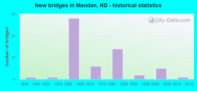
- New bridges - historical statistics
- 11940-1949
- 11950-1959
- 281960-1969
- 61970-1979
- 141980-1989
- 21990-1999
- 52000-2009
- 12010-2019

- Reconstructed bridges - Historical Statistics
- 91980-1989
- 01990-1999
- 12000-2009
- 12010-2019


- Bridge Condition - Deck
- 26.9%Very good
- 53.8%Good
- 15.4%Satisfactory
- 3.8%Fair

- Bridge Condition - Superstructure
- 3.8%Excellent
- 7.7%Very good
- 61.5%Good
- 23.1%Satisfactory
- 3.8%Fair

- Bridge Condition - Substructure
- 7.7%Excellent
- 7.7%Very good
- 57.7%Good
- 15.4%Satisfactory
- 11.5%Fair

- Bridge Condition - Channel
- 41.7%Excellent
- 33.3%Very good
- 8.3%Good
- 8.3%Satisfactory
- 8.3%Fair

- Bridge Condition - Culverts
- 33.3%Good
- 66.7%Satisfactory
Find on map >> Show street view
Structure Number: 810532, Location: MISTY WATERS (Lat: 46.868361, Lng: -100.871147), Route carried "on" structure: County highway , Year Built: 2006, Status: Open, Structure Length: 2.56m (8.40ft), Average Daily Traffic: 50 (year 2019), Truck Traffic: 5%, Average Future Daily Traffic: 60 (year 2039), Design Load: HS 25 or greater, Features Intersected: MISTY WATERS BAY, Facility Carried by Structure: MISTY WATERS ROAD
Minimum Vertical Clearance: 30+ m (98+ ft), Kilometerpoint: 0.000, Lanes on structure: 2, Owner: County Highway Agency, Approaching Roadway Width: 10.4m (34.1ft), Material/Design: Prestressed concrete, Design/Construction: Box Beam or Girders - Multiple, Number Of Spans In Main Unit: 1, Length of Maximum Span: 24.4m (80.1ft), Curb-To-Curb Width: 10.4m (34.1ft), Out-to-Out Width: 11.1m (36.4ft)
Condition: Deck: Very good, Superstructure: Excellent, Substructure: Very good, Channel: Very good, Inventory Rating: 51.9 metric tons, Method Used To Determine Inventory Rating: Load Factor (LF), Structural Evaluation: Equal to present desirable criteria, Deck Geometry: Superior to present desirable criteria, Waterway Adequacy: Superior to present desirable criteria, Approach Roadway Alignment: Equal to present desirable criteria, Designated Inspection Frequency: Every 24 months, Inspection Date: April 2021
Find on map >> Show street view
Structure Number: 3015205, Location: 5 NORTH 13 EAST OF JUDSON (Lat: 46.907350, Lng: -101.009900), Route carried "on" structure: County highway , Year Built: 1955, Status: Open, Structure Length: 0.94m (3.08ft), Average Daily Traffic: 50 (year 2018), Average Future Daily Traffic: 50 (year 2038), Features Intersected: CREEK, Facility Carried by Structure: 35TH STREET
Minimum Vertical Clearance: 30+ m (98+ ft), Kilometerpoint: 0.000, Lanes on structure: 2, Owner: County Highway Agency, Approaching Roadway Width: 6.7m (22.0ft), Material/Design: Prestressed concrete, Design/Construction: Tee Beam, Number Of Spans In Main Unit: 1, Length of Maximum Span: 8.8m (28.9ft), Curb or Sidewalk Widths: Left: 0.2m (0.7ft), Right: 0.2m (0.7ft), Curb-To-Curb Width: 7.0m (23.0ft), Out-to-Out Width: 7.5m (24.6ft)
Condition: Deck: Good, Superstructure: Good, Substructure: Good, Channel: Very good, Operating Rating: 71.1 metric tons, Method Used To Determine Operating Rating: Allowable Stress (AS), Inventory Rating: 30.6 metric tons, Method Used To Determine Inventory Rating: Allowable Stress (AS), Structural Evaluation: Better than present minimum criteria, Deck Geometry: Somewhat better than minimum adequacy, Waterway Adequacy: Better than present minimum criteria, Approach Roadway Alignment: Equal to present desirable criteria, Designated Inspection Frequency: Every 24 months, Inspection Date: July 2021, Deck Structure Type: Other
Find on map >> Show street view
Structure Number: MAN01, Location: LAKEWOOD HARBOR MANDAN (Lat: 46.800000, Lng: -100.833333), Route carried "on" structure: City street , Year Built: 2007, Status: Open, Structure Length: 2.44m (8.01ft), Average Daily Traffic: 250 (year 2019), Truck Traffic: 1%, Average Future Daily Traffic: 300 (year 2039), Design Load: HS 25 or greater, Features Intersected: WATER WAY, Facility Carried by Structure: MCKENZIE DR.SE
Minimum Vertical Clearance: 30+ m (98+ ft), Kilometerpoint: 0.000, Lanes on structure: 2, Owner: City or Municipal Highway Agency, Approaching Roadway Width: 14.6m (47.9ft), Material/Design: Prestressed concrete, Design/Construction: Box Beam or Girders - Multiple, Number Of Spans In Main Unit: 1, Length of Maximum Span: 22.7m (74.5ft), Curb or Sidewalk Widths: Left: 1.8m (5.9ft), Right: 0.0m, Curb-To-Curb Width: 14.9m (48.9ft), Out-to-Out Width: 17.4m (57.1ft)
Condition: Deck: Very good, Superstructure: Good, Substructure: Good, Channel: Excellent, Operating Rating: 89.8 metric tons, Method Used To Determine Operating Rating: Load Factor (LF), Inventory Rating: 69.3 metric tons, Method Used To Determine Inventory Rating: Load Factor (LF), Structural Evaluation: Better than present minimum criteria, Deck Geometry: Superior to present desirable criteria, Waterway Adequacy: Superior to present desirable criteria, Approach Roadway Alignment: Equal to present desirable criteria, Designated Inspection Frequency: Every 24 months, Inspection Date: April 2021, Wearing Surface/Protective System: Wearing Surface: Bituminous
Find on map >> Show street view
Structure Number: MAN02, Location: LAKEWOOD HARBOR MANDAN (Lat: 46.793333, Lng: -100.835000), Route carried "on" structure: City street , Year Built: 2007, Status: Open, Structure Length: 2.44m (8.01ft), Average Daily Traffic: 250 (year 2019), Truck Traffic: 1%, Average Future Daily Traffic: 300 (year 2039), Design Load: HS 25 or greater, Features Intersected: WATER WAY, Facility Carried by Structure: SOUTH BAY DR.SE
Minimum Vertical Clearance: 30+ m (98+ ft), Kilometerpoint: 0.000, Lanes on structure: 2, Owner: City or Municipal Highway Agency, Approaching Roadway Width: 12.2m (40.0ft), Material/Design: Prestressed concrete, Design/Construction: Box Beam or Girders - Multiple, Number Of Spans In Main Unit: 1, Length of Maximum Span: 22.7m (74.5ft), Curb or Sidewalk Widths: Left: 3.7m (12.1ft), Right: 0.0m, Curb-To-Curb Width: 9.3m (30.5ft), Out-to-Out Width: 13.7m (44.9ft)
Condition: Deck: Very good, Superstructure: Good, Substructure: Excellent, Channel: Excellent, Operating Rating: 89.8 metric tons, Method Used To Determine Operating Rating: Load Factor (LF), Inventory Rating: 69.3 metric tons, Method Used To Determine Inventory Rating: Load Factor (LF), Structural Evaluation: Better than present minimum criteria, Deck Geometry: Equal to present minimum criteria, Waterway Adequacy: Superior to present desirable criteria, Approach Roadway Alignment: Equal to present desirable criteria, Designated Inspection Frequency: Every 24 months, Inspection Date: April 2021, Wearing Surface/Protective System: Wearing Surface: Bituminous
Find on map >> Show street view
Structure Number: MAN03, Location: LAKEWOOD HARBOR MANDAN (Lat: 46.786667, Lng: -100.833333), Route carried "on" structure: City street , Year Built: 2007, Status: Open, Structure Length: 2.44m (8.01ft), Average Daily Traffic: 250 (year 2019), Truck Traffic: 1%, Average Future Daily Traffic: 300 (year 2039), Design Load: HS 25 or greater, Features Intersected: WATER WAY, Facility Carried by Structure: BAY SHORE BEND SE
Minimum Vertical Clearance: 30+ m (98+ ft), Kilometerpoint: 0.000, Lanes on structure: 2, Owner: City or Municipal Highway Agency, Approaching Roadway Width: 12.2m (40.0ft), Material/Design: Prestressed concrete, Design/Construction: Box Beam or Girders - Multiple, Number Of Spans In Main Unit: 1, Length of Maximum Span: 22.7m (74.5ft), Curb or Sidewalk Widths: Left: 0.0m, Right: 2.1m (6.9ft), Curb-To-Curb Width: 9.3m (30.5ft), Out-to-Out Width: 11.9m (39.0ft)
Condition: Deck: Very good, Superstructure: Very good, Substructure: Excellent, Channel: Excellent, Operating Rating: 89.8 metric tons, Method Used To Determine Operating Rating: Load Factor (LF), Inventory Rating: 69.3 metric tons, Method Used To Determine Inventory Rating: Load Factor (LF), Structural Evaluation: Equal to present desirable criteria, Deck Geometry: Equal to present minimum criteria, Waterway Adequacy: Superior to present desirable criteria, Approach Roadway Alignment: Equal to present desirable criteria, Designated Inspection Frequency: Every 24 months, Inspection Date: April 2021, Wearing Surface/Protective System: Wearing Surface: Bituminous
Find on map >> Show street view
Structure Number: 6066735, Location: 1 SOUTH OF MANDAN (Lat: 46.815000, Lng: -100.905000), Route carried "on" structure: State highway 6, Year Built: 1984, Status: Open, Structure Length: 9.63m (31.59ft), Average Daily Traffic: 3,550 (year 2019), Truck Traffic: 6%, Average Future Daily Traffic: 3,382 (year 2039), Design Load: HS 20, Features Intersected: HEART RIVER
Minimum Vertical Clearance: 30+ m (98+ ft), Kilometerpoint: 107.377, Lanes on structure: 2, Base Highway Network: Yes, Owner: State Highway Agency, Approaching Roadway Width: 13.4m (44.0ft), Skew: 2 degrees, Material/Design: Steel continuous, Design/Construction: Stringer/Multi-beam, Number Of Spans In Main Unit: 3, Length of Maximum Span: 40.5m (132.9ft), Curb-To-Curb Width: 13.4m (44.0ft), Out-to-Out Width: 16.9m (55.4ft)
Condition: Deck: Good, Superstructure: Good, Substructure: Good, Channel: Satisfactory, Operating Rating: 58.2 metric tons, Method Used To Determine Operating Rating: Load Factor (LF), Inventory Rating: 34.8 metric tons, Method Used To Determine Inventory Rating: Load Factor (LF), Structural Evaluation: Better than present minimum criteria, Deck Geometry: Better than present minimum criteria, Waterway Adequacy: Equal to present desirable criteria, Approach Roadway Alignment: Equal to present desirable criteria, Designated Inspection Frequency: Every 24 months, Inspection Date: July 2021, Deck Structure Type: Concrete Cast-file-Place, Wearing Surface/Protective System: Wearing Surface: Monolithic Concrete, Deck Protection: Epoxy Coated Reinforcing
Find on map >> Show street view
Structure Number: 6067352, Location: 10TH AVE & MAIN ST MANDAN (Lat: 46.825000, Lng: -100.903333), Route carried "on" structure: State highway 6, Year Built: 1990, Status: Open, Structure Length: 12.04m (39.50ft), Average Daily Traffic: 6,800 (year 2019), Truck Traffic: 4%, Average Future Daily Traffic: 8,000 (year 2039), Design Load: HS 25 or greater, Features Intersected: BURLINGTON NORTHERN RR
Minimum Vertical Clearance: 30+ m (98+ ft), Kilometerpoint: 108.369, Lanes on structure: 2, Base Highway Network: Yes, Owner: State Highway Agency, Approaching Roadway Width: 13.4m (44.0ft), Skew: 1 degrees, Material/Design: Steel continuous, Design/Construction: Stringer/Multi-beam, Number Of Spans In Main Unit: 3, Length of Maximum Span: 55.8m (183.1ft), Curb or Sidewalk Widths: Left: 0.0m, Right: 2.7m (8.9ft), Curb-To-Curb Width: 13.4m (44.0ft), Out-to-Out Width: 16.9m (55.4ft)
Condition: Deck: Good, Superstructure: Good, Substructure: Good, Operating Rating: 76.7 metric tons, Method Used To Determine Operating Rating: Load Factor (LF), Inventory Rating: 46.0 metric tons, Method Used To Determine Inventory Rating: Load Factor (LF), Structural Evaluation: Better than present minimum criteria, Deck Geometry: Equal to present minimum criteria, Underclear: Somewhat better than minimum adequacy, Approach Roadway Alignment: Equal to present desirable criteria, Designated Inspection Frequency: Every 24 months, Inspection Date: April 2021, Deck Structure Type: Concrete Cast-file-Place, Wearing Surface/Protective System: Wearing Surface: Monolithic Concrete, Deck Protection: Epoxy Coated Reinforcing
Find on map >> Show street view
Structure Number: 94147183, Location: JCT OF I-94 & ND 94 & 25 (Lat: 46.863242, Lng: -101.008172), Route carried "on" structure: State highway 25, Year Built: 1964, Year Reconstructed: 1987, Status: Open, Structure Length: 7.47m (24.51ft), Average Daily Traffic: 1,850 (year 2019), Truck Traffic: 13%, Average Future Daily Traffic: 2,280 (year 2039), Design Load: HS 20, Features Intersected: I-94/ND 94 & ND 25 INT, Facility Carried by Structure: ND HIGHWAY
Minimum Vertical Clearance: 30+ m (98+ ft), Kilometerpoint: 1462.245, Lanes on structure: 2, Lanes under structure: 4, Base Highway Network: Yes, Owner: State Highway Agency, Approaching Roadway Width: 14.0m (45.9ft), Material/Design: Prestressed concrete continuous, Design/Construction: Stringer/Multi-beam, Number Of Spans In Main Unit: 4, Length of Maximum Span: 20.1m (65.9ft), Curb-To-Curb Width: 12.3m (40.4ft), Out-to-Out Width: 13.0m (42.7ft)
Condition: Deck: Satisfactory, Superstructure: Good, Substructure: Good, Operating Rating: 89.8 metric tons, Method Used To Determine Operating Rating: Load Factor (LF), Inventory Rating: 54.7 metric tons, Method Used To Determine Inventory Rating: Load Factor (LF), Structural Evaluation: Better than present minimum criteria, Deck Geometry: Better than present minimum criteria, Underclear: Equal to present minimum criteria, Approach Roadway Alignment: Equal to present desirable criteria, Designated Inspection Frequency: Every 24 months, Inspection Date: April 2021, Deck Structure Type: Concrete Cast-file-Place, Wearing Surface/Protective System: Wearing Surface: Monolithic Concrete, Deck Protection: Epoxy Coated Reinforcing
Find on map >> Show street view
Structure Number: 94152329 L, Location: 5 EAST OF ND 25 (Lat: 46.845000, Lng: -100.906667), Route carried "on" structure: Interstate 94, Year Built: 1964, Year Reconstructed: 1985, Status: Open, Structure Length: 5.06m (16.60ft), Average Daily Traffic: 6,350 (year 2019), Truck Traffic: 10%, Average Future Daily Traffic: 6,350 (year 2039), Design Load: HS 20, Features Intersected: SUNSET DR/NW MANDAN INT.
Minimum Vertical Clearance: 30+ m (98+ ft), Kilometerpoint: 245.097, Lanes on structure: 2, Lanes under structure: 4, Base Highway Network: Yes, Owner: State Highway Agency, Approaching Roadway Width: 11.6m (38.1ft), Skew: 3 degrees, Material/Design: Steel continuous, Design/Construction: Stringer/Multi-beam, Number Of Spans In Main Unit: 3, Length of Maximum Span: 18.3m (60.0ft), Curb-To-Curb Width: 11.3m (37.1ft), Out-to-Out Width: 13.1m (43.0ft)
Condition: Deck: Very good, Superstructure: Good, Substructure: Good, Operating Rating: 58.2 metric tons, Method Used To Determine Operating Rating: Load Factor (LF), Inventory Rating: 34.8 metric tons, Method Used To Determine Inventory Rating: Load Factor (LF), Structural Evaluation: Better than present minimum criteria, Deck Geometry: Somewhat better than minimum adequacy, Underclear: High priority of corrective action, Approach Roadway Alignment: Equal to present desirable criteria, Length Of Structure Improvement: 5.06m (16.60ft), Designated Inspection Frequency: Every 24 months, Inspection Date: April 2021, Bridge Improvement Cost: $86,000, Roadway Improvement Cost: $9,000, Total Project Cost: $129,000, Deck Structure Type: Concrete Cast-file-Place, Wearing Surface/Protective System: Wearing Surface: Low Slump Concrete
Find on map >> Show street view
Structure Number: 94152329 R, Location: 5 EAST OF ND 25 (Lat: 46.845000, Lng: -100.906667), Route carried "on" structure: Interstate 94, Year Built: 1964, Year Reconstructed: 1985, Status: Open, Structure Length: 5.06m (16.60ft), Average Daily Traffic: 6,350 (year 2019), Truck Traffic: 10%, Average Future Daily Traffic: 6,350 (year 2039), Design Load: HS 20, Features Intersected: SUNSET DR/NW MANDAN INT.
Minimum Vertical Clearance: 30+ m (98+ ft), Kilometerpoint: 245.097, Lanes on structure: 2, Lanes under structure: 4, Base Highway Network: Yes, Owner: State Highway Agency, Approaching Roadway Width: 11.6m (38.1ft), Skew: 3 degrees, Material/Design: Steel continuous, Design/Construction: Stringer/Multi-beam, Number Of Spans In Main Unit: 3, Length of Maximum Span: 18.3m (60.0ft), Curb-To-Curb Width: 11.3m (37.1ft), Out-to-Out Width: 13.1m (43.0ft)
Condition: Deck: Very good, Superstructure: Good, Substructure: Good, Operating Rating: 58.2 metric tons, Method Used To Determine Operating Rating: Load Factor (LF), Inventory Rating: 34.8 metric tons, Method Used To Determine Inventory Rating: Load Factor (LF), Structural Evaluation: Better than present minimum criteria, Deck Geometry: Somewhat better than minimum adequacy, Underclear: High priority of corrective action, Approach Roadway Alignment: Equal to present desirable criteria, Length Of Structure Improvement: 5.06m (16.60ft), Designated Inspection Frequency: Every 24 months, Inspection Date: April 2021, Bridge Improvement Cost: $86,000, Roadway Improvement Cost: $9,000, Total Project Cost: $129,000, Deck Structure Type: Concrete Cast-file-Place, Wearing Surface/Protective System: Wearing Surface: Low Slump Concrete
Find on map >> Show street view
Structure Number: 94153068 L, Location: 6 EAST OF ND 25 (Lat: 46.841667, Lng: -100.891667), Route carried "on" structure: Interstate 94, Year Built: 1964, Year Reconstructed: 1985, Status: Open, Structure Length: 4.57m (14.99ft), Average Daily Traffic: 6,350 (year 2019), Truck Traffic: 10%, Average Future Daily Traffic: 6,350 (year 2039), Design Load: HS 20, Features Intersected: COLLINS AVENUE
Minimum Vertical Clearance: 30+ m (98+ ft), Kilometerpoint: 246.286, Lanes on structure: 2, Lanes under structure: 2, Base Highway Network: Yes, Owner: State Highway Agency, Approaching Roadway Width: 11.6m (38.1ft), Skew: 1 degrees, Material/Design: Steel continuous, Design/Construction: Stringer/Multi-beam, Number Of Spans In Main Unit: 3, Length of Maximum Span: 16.8m (55.1ft), Curb-To-Curb Width: 11.3m (37.1ft), Out-to-Out Width: 13.0m (42.7ft)
Condition: Deck: Good, Superstructure: Satisfactory, Substructure: Satisfactory, Operating Rating: 64.0 metric tons, Method Used To Determine Operating Rating: Load Factor (LF), Inventory Rating: 38.4 metric tons, Method Used To Determine Inventory Rating: Load Factor (LF), Structural Evaluation: Equal to present minimum criteria, Deck Geometry: Somewhat better than minimum adequacy, Underclear: Somewhat better than minimum adequacy, Approach Roadway Alignment: Equal to present desirable criteria, Designated Inspection Frequency: Every 24 months, Inspection Date: April 2021, Deck Structure Type: Concrete Cast-file-Place, Wearing Surface/Protective System: Wearing Surface: Low Slump Concrete
Find on map >> Show street view
Structure Number: 94153068 R, Location: 6 EAST OF ND 25 (Lat: 46.841667, Lng: -100.891667), Route carried "on" structure: Interstate 94, Year Built: 1964, Year Reconstructed: 1985, Status: Open, Structure Length: 4.57m (14.99ft), Average Daily Traffic: 6,350 (year 2019), Truck Traffic: 10%, Average Future Daily Traffic: 6,350 (year 2039), Design Load: HS 20, Features Intersected: COLLINS AVENUE
Minimum Vertical Clearance: 30+ m (98+ ft), Kilometerpoint: 246.286, Lanes on structure: 2, Lanes under structure: 2, Base Highway Network: Yes, Owner: State Highway Agency, Approaching Roadway Width: 11.6m (38.1ft), Skew: 1 degrees, Material/Design: Steel continuous, Design/Construction: Stringer/Multi-beam, Number Of Spans In Main Unit: 3, Length of Maximum Span: 16.8m (55.1ft), Curb-To-Curb Width: 11.3m (37.1ft), Out-to-Out Width: 13.0m (42.7ft)
Condition: Deck: Good, Superstructure: Satisfactory, Substructure: Satisfactory, Operating Rating: 64.0 metric tons, Method Used To Determine Operating Rating: Load Factor (LF), Inventory Rating: 38.4 metric tons, Method Used To Determine Inventory Rating: Load Factor (LF), Structural Evaluation: Equal to present minimum criteria, Deck Geometry: Somewhat better than minimum adequacy, Underclear: Somewhat better than minimum adequacy, Approach Roadway Alignment: Equal to present desirable criteria, Designated Inspection Frequency: Every 24 months, Inspection Date: April 2021, Deck Structure Type: Concrete Cast-file-Place, Wearing Surface/Protective System: Wearing Surface: Low Slump Concrete
Find on map >> Show street view
Structure Number: 94153988 L, Location: 5 WEST OF US 83 NORTH (Lat: 46.838333, Lng: -100.873333), Route carried "on" structure: Interstate 94, Year Built: 1964, Year Reconstructed: 1985, Status: Open, Structure Length: 6.25m (20.51ft), Average Daily Traffic: 7,750 (year 2019), Truck Traffic: 9%, Average Future Daily Traffic: 7,750 (year 2039), Design Load: H 20, Features Intersected: REFINERY ROAD INTERCHANG
Minimum Vertical Clearance: 30+ m (98+ ft), Kilometerpoint: 247.767, Lanes on structure: 2, Lanes under structure: 2, Base Highway Network: Yes, Owner: State Highway Agency, Approaching Roadway Width: 11.6m (38.1ft), Skew: 5 degrees, Material/Design: Steel continuous, Design/Construction: Stringer/Multi-beam, Number Of Spans In Main Unit: 3, Length of Maximum Span: 23.8m (78.1ft), Curb-To-Curb Width: 11.4m (37.4ft), Out-to-Out Width: 13.0m (42.7ft)
Condition: Deck: Good, Superstructure: Good, Substructure: Fair, Operating Rating: 57.8 metric tons, Method Used To Determine Operating Rating: Load Factor (LF), Inventory Rating: 34.6 metric tons, Method Used To Determine Inventory Rating: Load Factor (LF), Structural Evaluation: Somewhat better than minimum adequacy, Deck Geometry: Somewhat better than minimum adequacy, Underclear: Meets minimum limits, Approach Roadway Alignment: Equal to present desirable criteria, Designated Inspection Frequency: Every 24 months, Inspection Date: April 2021, Deck Structure Type: Concrete Cast-file-Place, Wearing Surface/Protective System: Wearing Surface: Low Slump Concrete
Find on map >> Show street view
Structure Number: 94153988 R, Location: 5 WEST OF US 83 NORTH (Lat: 46.841667, Lng: -100.873333), Route carried "on" structure: Interstate 94, Year Built: 1964, Year Reconstructed: 1985, Status: Open, Structure Length: 6.25m (20.51ft), Average Daily Traffic: 7,750 (year 2019), Truck Traffic: 9%, Average Future Daily Traffic: 7,750 (year 2039), Design Load: H 20, Features Intersected: REFINERY ROAD INTERCHANG
Minimum Vertical Clearance: 30+ m (98+ ft), Kilometerpoint: 247.767, Lanes on structure: 2, Lanes under structure: 2, Base Highway Network: Yes, Owner: State Highway Agency, Approaching Roadway Width: 11.6m (38.1ft), Skew: 5 degrees, Material/Design: Steel continuous, Design/Construction: Stringer/Multi-beam, Number Of Spans In Main Unit: 3, Length of Maximum Span: 23.8m (78.1ft), Curb-To-Curb Width: 11.4m (37.4ft), Out-to-Out Width: 13.0m (42.7ft)
Condition: Deck: Good, Superstructure: Satisfactory, Substructure: Fair, Operating Rating: 57.8 metric tons, Method Used To Determine Operating Rating: Load Factor (LF), Inventory Rating: 34.6 metric tons, Method Used To Determine Inventory Rating: Load Factor (LF), Structural Evaluation: Somewhat better than minimum adequacy, Deck Geometry: Somewhat better than minimum adequacy, Underclear: Meets minimum limits, Approach Roadway Alignment: Equal to present desirable criteria, Designated Inspection Frequency: Every 24 months, Inspection Date: April 2021, Deck Structure Type: Concrete Cast-file-Place, Wearing Surface/Protective System: Wearing Surface: Low Slump Concrete
Find on map >> Show street view
Structure Number: 94154232 L, Location: 5 WEST OF US 83 NORTH (Lat: 46.836667, Lng: -100.868333), Route carried "on" structure: Interstate 94, Year Built: 1964, Year Reconstructed: 1985, Status: Open, Structure Length: 5.49m (18.01ft), Average Daily Traffic: 7,750 (year 2019), Truck Traffic: 9%, Average Future Daily Traffic: 7,750 (year 2039), Design Load: HS 20, Features Intersected: BNRR AND MISSOURI ROAD
Minimum Vertical Clearance: 30+ m (98+ ft), Kilometerpoint: 248.159, Lanes on structure: 2, Lanes under structure: 2, Base Highway Network: Yes, Owner: State Highway Agency, Approaching Roadway Width: 11.6m (38.1ft), Skew: 1 degrees, Material/Design: Steel continuous, Design/Construction: Stringer/Multi-beam, Number Of Spans In Main Unit: 4, Length of Maximum Span: 14.6m (47.9ft), Curb-To-Curb Width: 12.3m (40.4ft), Out-to-Out Width: 13.9m (45.6ft)
Condition: Deck: Good, Superstructure: Good, Substructure: Fair, Operating Rating: 60.4 metric tons, Method Used To Determine Operating Rating: Load Factor (LF), Inventory Rating: 36.2 metric tons, Method Used To Determine Inventory Rating: Load Factor (LF), Structural Evaluation: Somewhat better than minimum adequacy, Deck Geometry: Better than present minimum criteria, Underclear: Superior to present desirable criteria, Approach Roadway Alignment: Equal to present desirable criteria, Designated Inspection Frequency: Every 24 months, Inspection Date: April 2021, Deck Structure Type: Concrete Cast-file-Place, Wearing Surface/Protective System: Wearing Surface: Low Slump Concrete
Find on map >> Show street view
Structure Number: 94154232 R, Location: 5 WEST OF US 83 NORTH (Lat: 46.836667, Lng: -100.868333), Route carried "on" structure: Interstate 94, Year Built: 1964, Year Reconstructed: 2010, Status: Open, Structure Length: 5.49m (18.01ft), Average Daily Traffic: 7,750 (year 2019), Truck Traffic: 9%, Average Future Daily Traffic: 7,750 (year 2039), Design Load: HS 20, Features Intersected: BNRR AND MISSOURI ROAD
Minimum Vertical Clearance: 30+ m (98+ ft), Kilometerpoint: 248.159, Lanes on structure: 2, Lanes under structure: 2, Base Highway Network: Yes, Owner: State Highway Agency, Approaching Roadway Width: 11.6m (38.1ft), Skew: 1 degrees, Material/Design: Steel continuous, Design/Construction: Stringer/Multi-beam, Number Of Spans In Main Unit: 4, Length of Maximum Span: 14.6m (47.9ft), Curb-To-Curb Width: 14.4m (47.2ft), Out-to-Out Width: 16.2m (53.1ft)
Condition: Deck: Satisfactory, Superstructure: Satisfactory, Substructure: Satisfactory, Operating Rating: 61.0 metric tons, Method Used To Determine Operating Rating: Load Factor (LF), Inventory Rating: 36.5 metric tons, Method Used To Determine Inventory Rating: Load Factor (LF), Structural Evaluation: Equal to present minimum criteria, Deck Geometry: Superior to present desirable criteria, Underclear: Superior to present desirable criteria, Approach Roadway Alignment: Equal to present desirable criteria, Designated Inspection Frequency: Every 24 months, Inspection Date: April 2021, Deck Structure Type: Concrete Cast-file-Place, Wearing Surface/Protective System: Wearing Surface: Low Slump Concrete
Find on map >> Show street view
Structure Number: 94155026 R, Location: 4 WEST OF US 83 NORTH (Lat: 46.828333, Lng: -100.858333), Route carried "on" structure: Ramp Interstate 94, Year Built: 1965, Year Reconstructed: 2000, Status: Open, Structure Length: 7.47m (24.51ft), Average Daily Traffic: 16,750 (year 2019), Truck Traffic: 6%, Average Future Daily Traffic: 16,750 (year 2039), Design Load: HS 20, Features Intersected: WEST MIDWAY SEPARATION
Minimum Vertical Clearance: 30+ m (98+ ft), Kilometerpoint: 249.437, Lanes on structure: 2, Lanes under structure: 2, Base Highway Network: Yes, Owner: State Highway Agency, Approaching Roadway Width: 11.6m (38.1ft), Skew: 5 degrees, Material/Design: Steel continuous, Design/Construction: Stringer/Multi-beam, Number Of Spans In Main Unit: 3, Length of Maximum Span: 27.1m (88.9ft), Curb-To-Curb Width: 9.1m (29.9ft), Out-to-Out Width: 10.9m (35.8ft)
Condition: Deck: Very good, Superstructure: Satisfactory, Substructure: Good, Operating Rating: 54.8 metric tons, Method Used To Determine Operating Rating: Load Factor (LF), Inventory Rating: 32.8 metric tons, Method Used To Determine Inventory Rating: Load Factor (LF), Structural Evaluation: Equal to present minimum criteria, Deck Geometry: Meets minimum limits, Underclear: Somewhat better than minimum adequacy, Approach Roadway Alignment: Equal to present desirable criteria, Length Of Structure Improvement: 7.47m (24.51ft), Designated Inspection Frequency: Every 24 months, Inspection Date: April 2021, Bridge Improvement Cost: $262,000, Roadway Improvement Cost: $26,000, Total Project Cost: $393,000, Deck Structure Type: Concrete Cast-file-Place, Wearing Surface/Protective System: Wearing Surface: Low Slump Concrete
Find on map >> Show street view
Structure Number: 94156069 R, Location: 3 WEST OF US 83 NORTH (Lat: 46.820000, Lng: -100.841667), Route carried "on" structure: Interstate 194, Year Built: 1965, Year Reconstructed: 1993, Status: Open, Structure Length: 6.71m (22.01ft), Average Daily Traffic: 9,100 (year 2019), Truck Traffic: 7%, Average Future Daily Traffic: 20,743 (year 2039), Design Load: HS 20, Features Intersected: EAST MIDWAY INTERCHANGE, Facility Carried by Structure: INTERSTATE 94
Minimum Vertical Clearance: 30+ m (98+ ft), Kilometerpoint: 0.002, Lanes on structure: 3, Lanes under structure: 4, Base Highway Network: Yes, Owner: State Highway Agency, Approaching Roadway Width: 18.6m (61.0ft), Skew: 33 degrees, Material/Design: Steel continuous, Design/Construction: Stringer/Multi-beam, Number Of Spans In Main Unit: 3, Length of Maximum Span: 25.9m (85.0ft), Curb-To-Curb Width: 15.5m (50.9ft), Out-to-Out Width: 17.6m (57.7ft)
Condition: Deck: Good, Superstructure: Fair, Substructure: Satisfactory, Operating Rating: 66.0 metric tons, Method Used To Determine Operating Rating: Load Factor (LF), Inventory Rating: 39.6 metric tons, Method Used To Determine Inventory Rating: Load Factor (LF), Structural Evaluation: Somewhat better than minimum adequacy, Deck Geometry: Somewhat better than minimum adequacy, Underclear: High priority of corrective action, Approach Roadway Alignment: Equal to present desirable criteria, Designated Inspection Frequency: Every 24 months, Inspection Date: October 2020, Deck Structure Type: Concrete Cast-file-Place, Wearing Surface/Protective System: Wearing Surface: Low Slump Concrete
Find on map >> Show street view
Structure Number: 94910922, Location: 5 WEST OF ND 6 (Lat: 46.841667, Lng: -100.993333), Route carried "on" structure: Business State highway 94, Year Built: 1948, Status: Open, Structure Length: 0.76m (2.49ft), Average Daily Traffic: 1,200 (year 2019), Truck Traffic: 14%, Average Future Daily Traffic: 1,570 (year 2039), Design Load: HS 20, Features Intersected: CREEK
Minimum Vertical Clearance: 30+ m (98+ ft), Kilometerpoint: 1465.673, Lanes on structure: 2, Base Highway Network: Yes, Owner: State Highway Agency, Approaching Roadway Width: 12.8m (42.0ft), Material/Design: Concrete, Design/Construction: Culvert, Number Of Spans In Main Unit: 3, Length of Maximum Span: 2.4m (7.9ft)
Condition: Channel: Fair, Culverts: Satisfactory, Operating Rating: 54.0 metric tons, Method Used To Determine Operating Rating: Load Factor (LF), Inventory Rating: 32.4 metric tons, Method Used To Determine Inventory Rating: Load Factor (LF), Structural Evaluation: Equal to present minimum criteria, Waterway Adequacy: Equal to present minimum criteria, Approach Roadway Alignment: Equal to present desirable criteria, Designated Inspection Frequency: Every 24 months, Inspection Date: July 2021
Find on map >> Show street view
Structure Number: 94912032, Location: 4 WEST OF ND 6 (Lat: 46.833583, Lng: -100.973908), Route carried "on" structure: Business State highway 94, Year Built: 2011, Status: Open, Structure Length: 10.64m (34.91ft), Average Daily Traffic: 1,475 (year 2019), Truck Traffic: 12%, Average Future Daily Traffic: 2,570 (year 2039), Design Load: HL 93, Features Intersected: HEART RIVER
Minimum Vertical Clearance: 30+ m (98+ ft), Kilometerpoint: 1467.461, Lanes on structure: 2, Base Highway Network: Yes, Owner: State Highway Agency, Approaching Roadway Width: 12.2m (40.0ft), Skew: 3 degrees, Material/Design: Prestressed concrete, Design/Construction: Stringer/Multi-beam, Number Of Spans In Main Unit: 3, Length of Maximum Span: 35.6m (116.8ft), Curb or Sidewalk Widths: Left: 0.4m (1.3ft), Right: 0.4m (1.3ft), Curb-To-Curb Width: 12.2m (40.0ft), Out-to-Out Width: 13.0m (42.7ft)
Condition: Deck: Good, Superstructure: Good, Substructure: Good, Channel: Excellent, Operating Rating: 44.4 metric tons, Method Used To Determine Operating Rating: Load and Resistance Factor Rating (LRFR) rating reported by rating factor(RF) method using HL-93 loadings, Inventory Rating: 34.0 metric tons, Method Used To Determine Inventory Rating: Load and Resistance Factor Rating (LRFR) rating reported by rating factor(RF) method using HL-93 loadings, Structural Evaluation: Better than present minimum criteria, Deck Geometry: Better than present minimum criteria, Waterway Adequacy: Equal to present desirable criteria, Approach Roadway Alignment: Equal to present desirable criteria, Designated Inspection Frequency: Every 24 months, Inspection Date: July 2021, Deck Structure Type: Concrete Cast-file-Place, Wearing Surface/Protective System: Wearing Surface: Monolithic Concrete, Deck Protection: Epoxy Coated Reinforcing
Find on map >> Show street view
Structure Number: 94915101, Location: 1 WEST OF ND 6 (Lat: 46.825000, Lng: -100.910000), Route carried "on" structure: Business State highway 94, Year Built: 2007, Status: Open, Structure Length: 10.21m (33.50ft), Average Daily Traffic: 3,260 (year 2019), Truck Traffic: 12%, Average Future Daily Traffic: 3,492 (year 2039), Design Load: HS 25 or greater, Features Intersected: HEART RIVER
Minimum Vertical Clearance: 30+ m (98+ ft), Kilometerpoint: 1472.398, Lanes on structure: 2, Base Highway Network: Yes, Owner: State Highway Agency, Approaching Roadway Width: 9.8m (32.2ft), Material/Design: Prestressed concrete continuous, Design/Construction: Stringer/Multi-beam, Number Of Spans In Main Unit: 3, Length of Maximum Span: 34.1m (111.9ft), Curb or Sidewalk Widths: Left: 0.4m (1.3ft), Right: 3.4m (11.2ft), Curb-To-Curb Width: 12.2m (40.0ft), Out-to-Out Width: 16.2m (53.1ft)
Condition: Deck: Good, Superstructure: Good, Substructure: Good, Channel: Excellent, Operating Rating: 89.8 metric tons, Method Used To Determine Operating Rating: Load Factor (LF), Inventory Rating: 56.0 metric tons, Method Used To Determine Inventory Rating: Load Factor (LF), Structural Evaluation: Better than present minimum criteria, Deck Geometry: Equal to present minimum criteria, Waterway Adequacy: Superior to present desirable criteria, Approach Roadway Alignment: Equal to present desirable criteria, Designated Inspection Frequency: Every 24 months, Inspection Date: July 2021, Deck Structure Type: Concrete Cast-file-Place, Wearing Surface/Protective System: Wearing Surface: Monolithic Concrete, Deck Protection: Epoxy Coated Reinforcing
Find on map >> Show street view
Structure Number: 94920395, Location: 2 EAST OF MANDAN (Lat: 46.808447, Lng: -100.828989), Route carried "on" structure: Ramp Interstate 194, Year Built: 1981, Status: Open, Structure Length: 7.83m (25.69ft), Average Daily Traffic: 18,200 (year 2019), Truck Traffic: 7%, Average Future Daily Traffic: 19,800 (year 2039), Design Load: HS 20, Features Intersected: BUSINESS LOOP 94
Minimum Vertical Clearance: 30+ m (98+ ft), Kilometerpoint: 1.725, Lanes on structure: 1, Lanes under structure: 2, Base Highway Network: Yes, Owner: State Highway Agency, Approaching Roadway Width: 7.3m (24.0ft), Skew: 3 degrees, Material/Design: Steel, Design/Construction: Stringer/Multi-beam, Number Of Spans In Main Unit: 3, Length of Maximum Span: 31.7m (104.0ft), Curb-To-Curb Width: 7.3m (24.0ft), Out-to-Out Width: 8.2m (26.9ft)
Condition: Deck: Satisfactory, Superstructure: Good, Substructure: Good, Operating Rating: 72.8 metric tons, Method Used To Determine Operating Rating: Load Factor (LF), Inventory Rating: 43.5 metric tons, Method Used To Determine Inventory Rating: Load Factor (LF), Structural Evaluation: Better than present minimum criteria, Deck Geometry: Better than present minimum criteria, Underclear: Equal to present minimum criteria, Approach Roadway Alignment: Equal to present desirable criteria, Designated Inspection Frequency: Every 24 months, Inspection Date: October 2020, Deck Structure Type: Concrete Cast-file-Place, Wearing Surface/Protective System: Wearing Surface: Monolithic Concrete, Deck Protection: Epoxy Coated Reinforcing
Find on map >> Show street view
Structure Number: 194001048 R, Location: 1 SOUTHEAST JUNCT 194 (Lat: 46.808161, Lng: -100.827694), Route carried "on" structure: Spur Interstate 194, Year Built: 1981, Status: Open, Structure Length: 14.78m (48.49ft), Average Daily Traffic: 9,100 (year 2020), Truck Traffic: 7%, Average Future Daily Traffic: 12,090 (year 2040), Design Load: HS 20, Features Intersected: BUSINESS 94
Minimum Vertical Clearance: 30+ m (98+ ft), Kilometerpoint: 1.686, Lanes on structure: 2, Lanes under structure: 8, Base Highway Network: Yes, Owner: State Highway Agency, Approaching Roadway Width: 13.7m (44.9ft), Skew: 13 degrees, Material/Design: Steel, Design/Construction: Stringer/Multi-beam, Number Of Spans In Main Unit: 4, Length of Maximum Span: 48.8m (160.1ft), Curb-To-Curb Width: 13.6m (44.6ft), Out-to-Out Width: 14.3m (46.9ft)
Condition: Deck: Good, Superstructure: Satisfactory, Substructure: Good, Operating Rating: 88.6 metric tons, Method Used To Determine Operating Rating: Load Factor (LF), Inventory Rating: 55.2 metric tons, Method Used To Determine Inventory Rating: Load Factor (LF), Structural Evaluation: Equal to present minimum criteria, Deck Geometry: Superior to present desirable criteria, Underclear: Better than present minimum criteria, Approach Roadway Alignment: Equal to present desirable criteria, Designated Inspection Frequency: Every 24 months, Inspection Date: October 2020, Deck Structure Type: Concrete Cast-file-Place, Wearing Surface/Protective System: Wearing Surface: Monolithic Concrete, Deck Protection: Epoxy Coated Reinforcing
Find on map >> Show street view
Structure Number: 194001054 L, Location: 1 SOUTHEAST OF JUNCT 194 (Lat: 46.808147, Lng: -100.827419), Route carried "on" structure: Spur Interstate 194, Year Built: 1981, Status: Open, Structure Length: 14.78m (48.49ft), Average Daily Traffic: 9,100 (year 2020), Truck Traffic: 7%, Average Future Daily Traffic: 20,964 (year 2040), Design Load: HS 20, Features Intersected: BUSINESS 94
Minimum Vertical Clearance: 30+ m (98+ ft), Kilometerpoint: 1.696, Lanes on structure: 2, Lanes under structure: 10, Base Highway Network: Yes, Owner: State Highway Agency, Approaching Roadway Width: 13.7m (44.9ft), Skew: 13 degrees, Material/Design: Steel, Design/Construction: Stringer/Multi-beam, Number Of Spans In Main Unit: 4, Length of Maximum Span: 48.8m (160.1ft), Curb-To-Curb Width: 13.6m (44.6ft), Out-to-Out Width: 14.3m (46.9ft)
Condition: Deck: Satisfactory, Superstructure: Good, Substructure: Good, Operating Rating: 88.6 metric tons, Method Used To Determine Operating Rating: Load Factor (LF), Inventory Rating: 55.2 metric tons, Method Used To Determine Inventory Rating: Load Factor (LF), Structural Evaluation: Better than present minimum criteria, Deck Geometry: Superior to present desirable criteria, Underclear: Somewhat better than minimum adequacy, Approach Roadway Alignment: Equal to present desirable criteria, Designated Inspection Frequency: Every 24 months, Inspection Date: October 2020, Deck Structure Type: Concrete Cast-file-Place, Wearing Surface/Protective System: Wearing Surface: Monolithic Concrete, Deck Protection: Epoxy Coated Reinforcing
Find on map >> Show street view
Structure Number: 810000493 L, Location: MCKENZIE DRIVE INT. (Lat: 46.800000, Lng: -100.826667), Route carried "on" structure: State highway 810, Year Built: 1984, Status: Open, Structure Length: 5.24m (17.19ft), Average Daily Traffic: 6,500 (year 2019), Truck Traffic: 3%, Average Future Daily Traffic: 14,640 (year 2039), Design Load: HS 20, Features Intersected: MCKENZIE DRIVE, Facility Carried by Structure: BISMARCK EXPWY
Minimum Vertical Clearance: 30+ m (98+ ft), Kilometerpoint: 0.793, Lanes on structure: 2, Lanes under structure: 2, Base Highway Network: Yes, Owner: State Highway Agency, Approaching Roadway Width: 11.3m (37.1ft), Material/Design: Prestressed concrete continuous, Design/Construction: Box Beam or Girders - Single/Spread, Number Of Spans In Main Unit: 3, Length of Maximum Span: 19.8m (65.0ft), Curb-To-Curb Width: 11.2m (36.7ft), Out-to-Out Width: 12.0m (39.4ft)
Condition: Deck: Good, Superstructure: Good, Substructure: Very good, Operating Rating: 78.3 metric tons, Method Used To Determine Operating Rating: Load Factor (LF), Inventory Rating: 46.9 metric tons, Method Used To Determine Inventory Rating: Load Factor (LF), Structural Evaluation: Better than present minimum criteria, Deck Geometry: Equal to present minimum criteria, Underclear: Superior to present desirable criteria, Approach Roadway Alignment: Equal to present desirable criteria, Designated Inspection Frequency: Every 24 months, Inspection Date: October 2020, Deck Structure Type: Concrete Cast-file-Place, Wearing Surface/Protective System: Wearing Surface: Monolithic Concrete, Deck Protection: Epoxy Coated Reinforcing
Find on map >> Show street view
Structure Number: 810000493 R, Location: MCKENZIE DRIVE INT. (Lat: 46.800000, Lng: -100.826667), Route carried "on" structure: State highway 810, Year Built: 1984, Status: Open, Structure Length: 5.24m (17.19ft), Average Daily Traffic: 6,500 (year 2019), Truck Traffic: 3%, Average Future Daily Traffic: 4,670 (year 2039), Design Load: HS 20, Features Intersected: MCKENZIE DRIVE, Facility Carried by Structure: BISMARCK EXPWY
Minimum Vertical Clearance: 30+ m (98+ ft), Kilometerpoint: 0.793, Lanes on structure: 2, Lanes under structure: 2, Base Highway Network: Yes, Owner: State Highway Agency, Approaching Roadway Width: 11.3m (37.1ft), Material/Design: Prestressed concrete continuous, Design/Construction: Box Beam or Girders - Single/Spread, Number Of Spans In Main Unit: 3, Length of Maximum Span: 19.8m (65.0ft), Curb-To-Curb Width: 11.2m (36.7ft), Out-to-Out Width: 12.0m (39.4ft)
Condition: Deck: Good, Superstructure: Very good, Substructure: Good, Operating Rating: 78.3 metric tons, Method Used To Determine Operating Rating: Load Factor (LF), Inventory Rating: 46.9 metric tons, Method Used To Determine Inventory Rating: Load Factor (LF), Structural Evaluation: Better than present minimum criteria, Deck Geometry: Equal to present minimum criteria, Underclear: Better than present minimum criteria, Approach Roadway Alignment: Equal to present desirable criteria, Designated Inspection Frequency: Every 24 months, Inspection Date: October 2020, Deck Structure Type: Concrete Cast-file-Place, Wearing Surface/Protective System: Wearing Surface: Monolithic Concrete, Deck Protection: Epoxy Coated Reinforcing
Find on map >> Show street view
Structure Number: 1804087763, Location: 5 WEST OF US 83 (Lat: 46.896375, Lng: -100.862156), Route carried "on" structure: State highway 1804, Year Built: 1979, Status: Open, Structure Length: 1.58m (5.18ft), Average Daily Traffic: 690 (year 2019), Truck Traffic: 6%, Average Future Daily Traffic: 690 (year 2039), Design Load: HS 20, Features Intersected: BURNT CREEK
Minimum Vertical Clearance: 30+ m (98+ ft), Kilometerpoint: 141.211, Lanes on structure: 2, Owner: State Highway Agency, Approaching Roadway Width: 9.1m (29.9ft), Skew: 2 degrees, Material/Design: Concrete, Design/Construction: Culvert, Number Of Spans In Main Unit: 4, Length of Maximum Span: 3.7m (12.1ft)
Condition: Channel: Very good, Culverts: Satisfactory, Operating Rating: 54.0 metric tons, Method Used To Determine Operating Rating: Load Factor (LF), Inventory Rating: 32.4 metric tons, Method Used To Determine Inventory Rating: Load Factor (LF), Structural Evaluation: Equal to present minimum criteria, Waterway Adequacy: Equal to present minimum criteria, Approach Roadway Alignment: Equal to present desirable criteria, Designated Inspection Frequency: Every 48 months, Inspection Date: April 2019
Find on map >> Show street view
Structure Number: 1806067137 N, Location: 3 SOUTH OF I-94 (Lat: 46.789469, Lng: -100.857031), Route carried "on" structure: State lands road , Year Built: 1997, Status: Open, Structure Length: 1.01m (3.31ft), Average Daily Traffic: 2,630 (year 2017), Truck Traffic: 6%, Average Future Daily Traffic: 3,945 (year 2037), Design Load: HS 25 or greater, Features Intersected: CREEK, Facility Carried by Structure: PARK APPROACH RD.
Minimum Vertical Clearance: 30+ m (98+ ft), Kilometerpoint: 108.023, Lanes on structure: 2, Owner: State Highway Agency, Approaching Roadway Width: 9.8m (32.2ft), Skew: 3 degrees, Material/Design: Concrete, Design/Construction: Culvert, Number Of Spans In Main Unit: 2, Length of Maximum Span: 4.9m (16.1ft)
Condition: Channel: Good, Culverts: Good, Operating Rating: 67.5 metric tons, Method Used To Determine Operating Rating: Load Factor (LF), Inventory Rating: 40.5 metric tons, Method Used To Determine Inventory Rating: Load Factor (LF), Structural Evaluation: Better than present minimum criteria, Waterway Adequacy: Superior to present desirable criteria, Approach Roadway Alignment: Equal to present desirable criteria, Designated Inspection Frequency: Every 48 months, Inspection Date: June 2020
Find on map >> Show street view
Structure Number: 1806069384, Location: 1 SOUTH OF I-94 (Lat: 46.816667, Lng: -100.880000), Route carried "on" structure: State highway 1806, Year Built: 1976, Status: Open, Structure Length: 7.65m (25.10ft), Average Daily Traffic: 7,360 (year 2019), Truck Traffic: 3%, Average Future Daily Traffic: 6,472 (year 2039), Design Load: HS 20, Features Intersected: HEART RIVER
Minimum Vertical Clearance: 30+ m (98+ ft), Kilometerpoint: 111.639, Lanes on structure: 2, Base Highway Network: Yes, Owner: State Highway Agency, Approaching Roadway Width: 12.2m (40.0ft), Material/Design: Steel continuous, Design/Construction: Stringer/Multi-beam, Number Of Spans In Main Unit: 3, Length of Maximum Span: 46.0m (150.9ft), Curb or Sidewalk Widths: Left: 0.0m, Right: 2.7m (8.9ft), Curb-To-Curb Width: 12.3m (40.4ft), Out-to-Out Width: 16.3m (53.5ft)
Condition: Deck: Fair, Superstructure: Good, Substructure: Good, Channel: Very good, Operating Rating: 89.8 metric tons, Method Used To Determine Operating Rating: Load Factor (LF), Inventory Rating: 56.2 metric tons, Method Used To Determine Inventory Rating: Load Factor (LF), Structural Evaluation: Better than present minimum criteria, Deck Geometry: Somewhat better than minimum adequacy, Waterway Adequacy: Equal to present desirable criteria, Approach Roadway Alignment: Equal to present desirable criteria, Designated Inspection Frequency: Every 24 months, Inspection Date: July 2021, Deck Structure Type: Concrete Cast-file-Place, Wearing Surface/Protective System: Wearing Surface: Monolithic Concrete
Find on map >> Show street view
Structure Number: 94147183, Location: JCT OF I-94 & ND 94 & 25 (Lat: 46.863242, Lng: -101.008172), Route carried "under" structure: Interstate 94, Year Built: 1964, Structure Length: 0. m, Average Daily Traffic: 7,700 (year 2011), Truck Traffic: 16%, Features Intersected: I-94/ND 94 & ND 25 INT, Facility Carried by Structure: ND HIGHWAY
Minimum Vertical Clearance: 5.18m (16.99ft), Kilometerpoint: 236.868, Lanes on structure: 2, Lanes under structure: 2, Material/Design: Prestressed concrete continuous, Design/Construction: Stringer/Multi-beam, Length of Maximum Span: 20.1m (65.9ft)
Find on map >> Show street view
Structure Number: 94147183, Location: JCT OF I-94 & ND 94 & 25 (Lat: 46.863242, Lng: -101.008172), Route carried "under" structure: Interstate 94, Year Built: 1964, Structure Length: 0. m, Average Daily Traffic: 7,700 (year 2011), Truck Traffic: 16%, Features Intersected: I-94/ND 94 & ND 25 INT, Facility Carried by Structure: ND HIGHWAY
Minimum Vertical Clearance: 5.14m (16.86ft), Kilometerpoint: 236.868, Lanes on structure: 2, Lanes under structure: 2, Material/Design: Prestressed concrete continuous, Design/Construction: Stringer/Multi-beam, Length of Maximum Span: 20.1m (65.9ft)
Find on map >> Show street view
Structure Number: 94152329 L, Location: 5 EAST OF ND 25 (Lat: 46.845000, Lng: -100.906667), Route carried "under" structure: City street , Year Built: 1964, Structure Length: 0. m, Average Daily Traffic: 6,000 (year 2011), Truck Traffic: 10%, Features Intersected: SUNSET DR/NW MANDAN INT., Facility Carried by Structure: INTERSTATE 94
Minimum Vertical Clearance: 4.48m (14.70ft), Kilometerpoint: 0.000, Lanes on structure: 2, Lanes under structure: 2, Material/Design: Steel continuous, Design/Construction: Stringer/Multi-beam, Length of Maximum Span: 18.3m (60.0ft)
Find on map >> Show street view
Structure Number: 94152329 R, Location: 5 EAST OF ND 25 (Lat: 46.845000, Lng: -100.906667), Route carried "under" structure: City street , Year Built: 1964, Structure Length: 0. m, Average Daily Traffic: 6,000 (year 2011), Truck Traffic: 10%, Features Intersected: SUNSET DR/NW MANDAN INT., Facility Carried by Structure: INTERSTATE 94
Minimum Vertical Clearance: 4.39m (14.40ft), Kilometerpoint: 0.000, Lanes on structure: 2, Lanes under structure: 2, Material/Design: Steel continuous, Design/Construction: Stringer/Multi-beam, Length of Maximum Span: 18.3m (60.0ft)
Find on map >> Show street view
Structure Number: 94153068 L, Location: 6 EAST OF ND 25 (Lat: 46.841667, Lng: -100.891667), Route carried "under" structure: City street , Year Built: 1964, Structure Length: 0. m, Average Daily Traffic: 6,350 (year 2011), Truck Traffic: 10%, Features Intersected: COLLINS AVENUE, Facility Carried by Structure: INTERSTATE 94
Minimum Vertical Clearance: 4.34m (14.24ft), Kilometerpoint: 0.000, Lanes on structure: 2, Lanes under structure: 2, Material/Design: Steel continuous, Design/Construction: Stringer/Multi-beam, Length of Maximum Span: 16.8m (55.1ft)
Find on map >> Show street view
Structure Number: 94153068 R, Location: 6 EAST OF ND 25 (Lat: 46.841667, Lng: -100.891667), Route carried "under" structure: City street , Year Built: 1964, Structure Length: 0. m, Average Daily Traffic: 6,350 (year 2011), Truck Traffic: 10%, Features Intersected: COLLINS AVENUE, Facility Carried by Structure: INTERSTATE 94
Minimum Vertical Clearance: 4.35m (14.27ft), Kilometerpoint: 0.000, Lanes on structure: 2, Lanes under structure: 2, Material/Design: Steel continuous, Design/Construction: Stringer/Multi-beam, Length of Maximum Span: 16.8m (55.1ft)
Find on map >> Show street view
Structure Number: 94153988 L, Location: 5 WEST OF US 83 NORTH (Lat: 46.838333, Lng: -100.873333), Route carried "under" structure: State highway 1806, Year Built: 1964, Structure Length: 0. m, Average Daily Traffic: 7,750 (year 2011), Truck Traffic: 9%, Features Intersected: REFINERY ROAD INTERCHANG, Facility Carried by Structure: INTERSTATE 94
Minimum Vertical Clearance: 5.02m (16.47ft), Kilometerpoint: 114.626, Lanes on structure: 2, Lanes under structure: 2, Material/Design: Steel continuous, Design/Construction: Stringer/Multi-beam, Length of Maximum Span: 23.8m (78.1ft)
Find on map >> Show street view
Structure Number: 94153988 R, Location: 5 WEST OF US 83 NORTH (Lat: 46.841667, Lng: -100.873333), Route carried "under" structure: State highway 1806, Year Built: 1964, Structure Length: 0. m, Average Daily Traffic: 7,750 (year 2011), Truck Traffic: 9%, Features Intersected: REFINERY ROAD INTERCHANG, Facility Carried by Structure: INTERSTATE 94
Minimum Vertical Clearance: 5.12m (16.80ft), Kilometerpoint: 114.626, Lanes on structure: 2, Lanes under structure: 2, Material/Design: Steel continuous, Design/Construction: Stringer/Multi-beam, Length of Maximum Span: 23.8m (78.1ft)
Find on map >> Show street view
Structure Number: 94154232 L, Location: 5 WEST OF US 83 NORTH (Lat: 46.836667, Lng: -100.868333), Route carried "under" structure: City street , Year Built: 1964, Structure Length: 0. m, Average Daily Traffic: 7,750 (year 2011), Truck Traffic: 9%, Features Intersected: BNRR AND MISSOURI ROAD, Facility Carried by Structure: INTERSTATE 94
Minimum Vertical Clearance: 6.46m (21.19ft), Kilometerpoint: 0.000, Lanes on structure: 2, Lanes under structure: 2, Material/Design: Steel continuous, Design/Construction: Stringer/Multi-beam, Length of Maximum Span: 14.6m (47.9ft)
Find on map >> Show street view
Structure Number: 94154232 R, Location: 5 WEST OF US 83 NORTH (Lat: 46.836667, Lng: -100.868333), Route carried "under" structure: City street , Year Built: 1964, Structure Length: 0. m, Average Daily Traffic: 7,750 (year 2011), Truck Traffic: 9%, Features Intersected: BNRR AND MISSOURI ROAD, Facility Carried by Structure: INTERSTATE 94
Minimum Vertical Clearance: 6.32m (20.73ft), Kilometerpoint: 0.000, Lanes on structure: 2, Lanes under structure: 2, Material/Design: Steel continuous, Design/Construction: Stringer/Multi-beam, Length of Maximum Span: 14.6m (47.9ft)
Find on map >> Show street view
Structure Number: 94155026 R, Location: 4 WEST OF US 83 NORTH (Lat: 46.828333, Lng: -100.858333), Route carried "under" structure: Interstate 94, Year Built: 1965, Structure Length: 0. m, Average Daily Traffic: 16,750 (year 2011), Truck Traffic: 6%, Features Intersected: WEST MIDWAY SEPARATION
Minimum Vertical Clearance: 4.95m (16.24ft), Kilometerpoint: 249.490, Lanes on structure: 2, Lanes under structure: 2, Material/Design: Steel continuous, Design/Construction: Stringer/Multi-beam, Length of Maximum Span: 27.1m (88.9ft)
Find on map >> Show street view
Structure Number: 94156069 R, Location: 3 WEST OF US 83 NORTH (Lat: 46.820000, Lng: -100.841667), Route carried "under" structure: Interstate 94, Year Built: 1965, Structure Length: 0. m, Average Daily Traffic: 11,100 (year 2011), Truck Traffic: 9%, Features Intersected: EAST MIDWAY INTERCHANGE
Minimum Vertical Clearance: 5.54m (18.18ft), Kilometerpoint: 251.169, Lanes on structure: 3, Lanes under structure: 2, Material/Design: Steel continuous, Design/Construction: Stringer/Multi-beam, Length of Maximum Span: 25.9m (85.0ft)
Find on map >> Show street view
Structure Number: 94156069 R, Location: 3 WEST OF US 83 NORTH (Lat: 46.820000, Lng: -100.841667), Route carried "under" structure: Interstate 94, Year Built: 1965, Structure Length: 0. m, Average Daily Traffic: 11,100 (year 2011), Truck Traffic: 9%, Features Intersected: EAST MIDWAY INTERCHANGE
Minimum Vertical Clearance: 5.05m (16.57ft), Kilometerpoint: 251.169, Lanes on structure: 3, Lanes under structure: 2, Material/Design: Steel continuous, Design/Construction: Stringer/Multi-beam, Length of Maximum Span: 25.9m (85.0ft)
Find on map >> Show street view
Structure Number: 94917168 B, Location: EAST MANDAN TO 94 (Lat: 46.829197, Lng: -100.868764), Route carried "under" structure: Business Interstate 94, Year Built: 1965, Structure Length: 0. m, Average Daily Traffic: 19,600 (year 2012), Truck Traffic: 3%, Features Intersected: BNRR-KILLDEER, Facility Carried by Structure: BNRR
Minimum Vertical Clearance: 4.82m (15.81ft), Kilometerpoint: 1476.039, Lanes under structure: 2, Material/Design: Steel, Design/Construction: Stringer/Multi-beam, Length of Maximum Span: 7.3m (24.0ft)
Find on map >> Show street view
Structure Number: 94917168 B, Location: EAST MANDAN TO 94 (Lat: 46.829197, Lng: -100.868764), Route carried "under" structure: Business Interstate 94, Year Built: 1965, Structure Length: 0. m, Average Daily Traffic: 19,600 (year 2012), Truck Traffic: 3%, Features Intersected: BNRR-KILLDEER, Facility Carried by Structure: BNRR
Minimum Vertical Clearance: 4.86m (15.94ft), Kilometerpoint: 1476.039, Lanes under structure: 2, Material/Design: Steel, Design/Construction: Stringer/Multi-beam, Length of Maximum Span: 7.3m (24.0ft)
Find on map >> Show street view
Structure Number: 94917953 B, Location: EAST MANDAN THE STRIP (Lat: 46.828311, Lng: -100.870994), Route carried "under" structure: Business Interstate 94, Year Built: 1979, Structure Length: 0. m, Average Daily Traffic: 5,810 (year 2009), Truck Traffic: 5%, Features Intersected: BNRR SEPARATION, Facility Carried by Structure: BNRR
Minimum Vertical Clearance: 4.99m (16.37ft), Kilometerpoint: 1476.986, Lanes under structure: 2, Material/Design: Steel, Design/Construction: Stringer/Multi-beam, Length of Maximum Span: 11.3m (37.1ft)
Find on map >> Show street view
Structure Number: 94917953 B, Location: EAST MANDAN THE STRIP (Lat: 46.828311, Lng: -100.870994), Route carried "under" structure: Business Interstate 94, Year Built: 1979, Structure Length: 0. m, Average Daily Traffic: 5,810 (year 2011), Truck Traffic: 5%, Features Intersected: BNRR SEPARATION, Facility Carried by Structure: BNRR
Minimum Vertical Clearance: 5.21m (17.09ft), Kilometerpoint: 1476.987, Lanes under structure: 2, Material/Design: Steel, Design/Construction: Stringer/Multi-beam, Length of Maximum Span: 11.3m (37.1ft)
Find on map >> Show street view
Structure Number: 94917969 B, Location: EAST MANDAN the STRIP (Lat: 46.828067, Lng: -100.870828), Route carried "under" structure: Business Interstate 94, Year Built: 1979, Structure Length: 0. m, Average Daily Traffic: 5,820 (year 2009), Truck Traffic: 5%, Features Intersected: BNRR SEPARATION, Facility Carried by Structure: BNRR
Minimum Vertical Clearance: 4.95m (16.24ft), Kilometerpoint: 1477.328, Lanes under structure: 2, Material/Design: Steel, Design/Construction: Stringer/Multi-beam, Length of Maximum Span: 11.3m (37.1ft)
Find on map >> Show street view
Structure Number: 94917969 B, Location: EAST MANDAN the STRIP (Lat: 46.828067, Lng: -100.870828), Route carried "under" structure: Business Interstate 94, Year Built: 1979, Structure Length: 0. m, Average Daily Traffic: 5,820 (year 2011), Truck Traffic: 5%, Features Intersected: BNRR SEPARATION, Facility Carried by Structure: BNRR
Minimum Vertical Clearance: 4.94m (16.21ft), Kilometerpoint: 1477.328, Lanes under structure: 2, Material/Design: Steel, Design/Construction: Stringer/Multi-beam, Length of Maximum Span: 11.3m (37.1ft)
Find on map >> Show street view
Structure Number: 94920395, Location: 2 EAST OF MANDAN (Lat: 46.808447, Lng: -100.828989), Route carried "under" structure: Business Interstate 94, Year Built: 1981, Structure Length: 0. m, Average Daily Traffic: 12,900 (year 2011), Truck Traffic: 3%, Features Intersected: BUSINESS LOOP 94
Minimum Vertical Clearance: 4.74m (15.55ft), Kilometerpoint: 1481.232, Lanes on structure: 1, Lanes under structure: 2, Material/Design: Steel, Design/Construction: Stringer/Multi-beam, Length of Maximum Span: 31.7m (104.0ft)
Find on map >> Show street view
Structure Number: 194000355 B, Location: SOUTH OF I-94 (Lat: 46.816667, Lng: -100.836667), Route carried "under" structure: Business Interstate 194, Year Built: 1963, Structure Length: 0. m, Average Daily Traffic: 18,200 (year 2010), Truck Traffic: 7%, Features Intersected: BNRR SEPARATION, Facility Carried by Structure: BNRR
Minimum Vertical Clearance: 6.12m (20.08ft), Kilometerpoint: 0.571, Lanes under structure: 2, Material/Design: Steel, Design/Construction: Stringer/Multi-beam, Length of Maximum Span: 18.3m (60.0ft)
Find on map >> Show street view
Structure Number: 194000355 B, Location: SOUTH OF I-94 (Lat: 46.816667, Lng: -100.836667), Route carried "under" structure: Business Interstate 194, Year Built: 1963, Structure Length: 0. m, Average Daily Traffic: 18,200 (year 2010), Truck Traffic: 7%, Features Intersected: BNRR SEPARATION, Facility Carried by Structure: BNRR
Minimum Vertical Clearance: 5.89m (19.32ft), Kilometerpoint: 0.571, Lanes under structure: 2, Material/Design: Steel, Design/Construction: Stringer/Multi-beam, Length of Maximum Span: 18.3m (60.0ft)
Find on map >> Show street view
Structure Number: 194001048 R, Location: 1 SOUTHEAST JUNCT 194 (Lat: 46.808161, Lng: -100.827694), Route carried "under" structure: Business Interstate 194, Year Built: 1981, Structure Length: 0. m, Average Daily Traffic: 1,400 (year 2013), Truck Traffic: 27%, Features Intersected: BUSINESS 94
Minimum Vertical Clearance: 5.49m (18.01ft), Kilometerpoint: 1.687, Lanes on structure: 2, Lanes under structure: 4, Material/Design: Steel, Design/Construction: Stringer/Multi-beam, Length of Maximum Span: 48.8m (160.1ft)
Find on map >> Show street view
Structure Number: 194001048 R, Location: 1 SOUTHEAST JUNCT 194 (Lat: 46.808161, Lng: -100.827694), Route carried "under" structure: Business Interstate 194, Year Built: 1981, Structure Length: 0. m, Average Daily Traffic: 1,400 (year 2011), Truck Traffic: 27%, Features Intersected: BUSINESS 94
Minimum Vertical Clearance: 4.95m (16.24ft), Kilometerpoint: 1.687, Lanes on structure: 2, Lanes under structure: 4, Material/Design: Steel, Design/Construction: Stringer/Multi-beam, Length of Maximum Span: 48.8m (160.1ft)
Find on map >> Show street view
Structure Number: 194001054 L, Location: 1 SOUTHEAST OF JUNCT 194 (Lat: 46.808147, Lng: -100.827419), Route carried "under" structure: Business Interstate 194, Year Built: 1981, Structure Length: 0. m, Average Daily Traffic: 1,400 (year 2011), Truck Traffic: 27%, Features Intersected: BUSINESS 94
Minimum Vertical Clearance: 6.16m (20.21ft), Kilometerpoint: 1.696, Lanes on structure: 2, Lanes under structure: 5, Material/Design: Steel, Design/Construction: Stringer/Multi-beam, Length of Maximum Span: 48.8m (160.1ft)
Find on map >> Show street view
Structure Number: 194001054 L, Location: 1 SOUTHEAST OF JUNCT 194 (Lat: 46.808147, Lng: -100.827419), Route carried "under" structure: Business Interstate 194, Year Built: 1981, Structure Length: 0. m, Average Daily Traffic: 1,400 (year 2013), Truck Traffic: 27%, Features Intersected: BUSINESS 94
Minimum Vertical Clearance: 6.07m (19.91ft), Kilometerpoint: 1.696, Lanes on structure: 2, Lanes under structure: 5, Material/Design: Steel, Design/Construction: Stringer/Multi-beam, Length of Maximum Span: 48.8m (160.1ft)
Find on map >> Show street view
Structure Number: 810000493 L, Location: MCKENZIE DRIVE INT. (Lat: 46.800000, Lng: -100.826667), Route carried "under" structure: ServiceCity street , Year Built: 1984, Structure Length: 0. m, Average Daily Traffic: 300 (year 2013), Truck Traffic: 5%, Features Intersected: MCKENZIE DRIVE, Facility Carried by Structure: BISMARCK EXPWY
Minimum Vertical Clearance: 5.05m (16.57ft), Kilometerpoint: 0.000, Lanes on structure: 2, Lanes under structure: 2, Material/Design: Prestressed concrete continuous, Design/Construction: Box Beam or Girders - Single/Spread, Length of Maximum Span: 19.8m (65.0ft)