Bridge Statistics for Lower Allen, Pennsylvania (PA)
Condition, Traffic, Stress, Structural Evaluation, Project Costs
- National Bridge Inventory (NBI) Statistics
- 47Number of bridges
- 449ft / 137mTotal length
- $10,201,000Total costs
- 892,234Total average daily traffic
- 116,574Total average daily truck traffic
- National Bridge Inventory (NBI) Registered Bridges for Lower Allen
- No street view available for this location
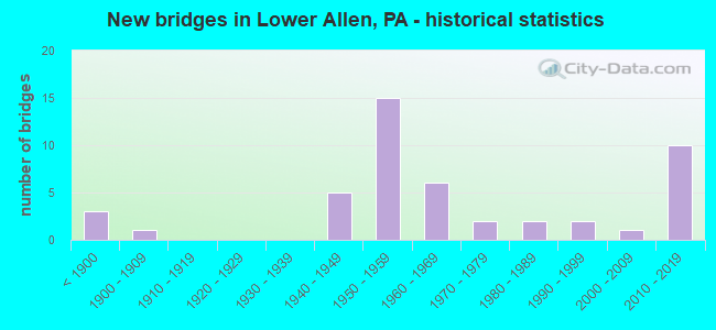
- New bridges - historical statistics
- 3Before 1900
- 11900-1909
- 51940-1949
- 151950-1959
- 61960-1969
- 21970-1979
- 21980-1989
- 21990-1999
- 12000-2009
- 102010-2019

- Reconstructed bridges - Historical Statistics
- 11950-1959
- 01960-1969
- 11970-1979
- 31980-1989
- 01990-1999
- 42000-2009


- Bridge Condition - Deck
- 3.8%Excellent
- 7.7%Very good
- 42.3%Good
- 23.1%Satisfactory
- 15.4%Fair
- 3.8%Poor
- 3.8%Serious

- Bridge Condition - Superstructure
- 3.7%Excellent
- 7.4%Very good
- 29.6%Good
- 29.6%Satisfactory
- 14.8%Fair
- 3.7%Poor
- 3.7%Serious
- 3.7%Critical
- 3.7%Imminent failure

- Bridge Condition - Substructure
- 11.1%Very good
- 22.2%Good
- 25.9%Satisfactory
- 37.0%Fair
- 3.7%Poor

- Bridge Condition - Channel
- 17.6%Very good
- 11.8%Good
- 17.6%Satisfactory
- 47.1%Fair
- 5.9%Poor

- Bridge Condition - Culverts
- 25.0%Excellent
- 50.0%Good
- 25.0%Fair
Find on map >> Show street view
Structure Number: 13724, Location: LISBURN (Lat: 40.167928, Lng: -76.907261), Route carried "on" structure: State highway 114, Year Built: 1906, Year Reconstructed: 1982, Status: Open, Structure Length: 1.07m (3.51ft), Average Daily Traffic: 3,756 (year 2020), Truck Traffic: 3%, Average Future Daily Traffic: 8,207 (year 2032), Design Load: HS 20, Features Intersected: MILL RACE
Minimum Vertical Clearance: 30+ m (98+ ft), Kilometerpoint: 21.651, Lanes on structure: 2, Owner: State Highway Agency, Approaching Roadway Width: 8.5m (27.9ft), Skew: 4 degrees, Material/Design: Steel, Design/Construction: Stringer/Multi-beam, Number Of Spans In Main Unit: 1, Length of Maximum Span: 9.1m (29.9ft), Curb-To-Curb Width: 7.9m (25.9ft), Out-to-Out Width: 9.0m (29.5ft)
Condition: Deck: Satisfactory, Superstructure: Fair, Substructure: Poor, Channel: Fair, Operating Rating: 79.8 metric tons, Method Used To Determine Operating Rating: Load Factor (LF), Inventory Rating: 47.2 metric tons, Method Used To Determine Inventory Rating: Load Factor (LF), Structural Evaluation: Meets minimum limits, Deck Geometry: High priority of corrective action, Waterway Adequacy: Better than present minimum criteria, Approach Roadway Alignment: Equal to present desirable criteria, Length Of Structure Improvement: 1.80m (5.91ft), Designated Inspection Frequency: Every 24 months, Inspection Date: May 2020, Bridge Improvement Cost: $8,000, Roadway Improvement Cost: $22,000, Total Project Cost: $103,000, Deck Structure Type: Concrete Cast-file-Place, Wearing Surface/Protective System: Wearing Surface: Monolithic Concrete, Deck Protection: Epoxy Coated Reinforcing
Find on map >> Show street view
Structure Number: 13763, Location: LOWER ALLEN TWP (Lat: 40.234722, Lng: -76.913897), Route carried "on" structure: State highway 581, Year Built: 1960, Year Reconstructed: 2008, Status: Open, Structure Length: 40.08m (131.50ft), Average Daily Traffic: 85,079 (year 2021), Truck Traffic: 9%, Average Future Daily Traffic: 110,987 (year 2032), Design Load: HS 20, Features Intersected: SR 2014,SR 2033,NORFLK S
Minimum Vertical Clearance: 30+ m (98+ ft), Kilometerpoint: 9.827, Lanes on structure: 3, Lanes under structure: 5, Base Highway Network: Yes, Owner: State Highway Agency, Approaching Roadway Width: 18.3m (60.0ft), Skew: 36 degrees, Material/Design: Steel continuous, Design/Construction: Girder and Floorbeam System, Number Of Spans In Main Unit: 2, Number Of Approach Spans: 15, Length of Maximum Span: 36.6m (120.1ft), Curb or Sidewalk Widths: Left: 0.2m (0.7ft), Right: 0.2m (0.7ft), Curb-To-Curb Width: 23.4m (76.8ft), Out-to-Out Width: 25.5m (83.7ft)
Condition: Deck: Good, Superstructure: Satisfactory, Substructure: Fair, Operating Rating: 56.2 metric tons, Method Used To Determine Operating Rating: Load Factor (LF), Inventory Rating: 33.6 metric tons, Method Used To Determine Inventory Rating: Load Factor (LF), Structural Evaluation: Somewhat better than minimum adequacy, Deck Geometry: Superior to present desirable criteria, Underclear: High priority of corrective action, Approach Roadway Alignment: Equal to present desirable criteria, Length Of Structure Improvement: 40.70m (133.53ft), Designated Inspection Frequency: Every 24 months, Critical Feature Inspection Frequency: Every 24 months, Inspection Date: June 2020, Critical Feature Inspection Date: June 2020, Bridge Improvement Cost: $71,000, Roadway Improvement Cost: $210,000, Total Project Cost: $963,000, Deck Structure Type: Concrete Cast-file-Place, Wearing Surface/Protective System: Wearing Surface: Monolithic Concrete, Deck Protection: Epoxy Coated Reinforcing
Find on map >> Show street view
Structure Number: 13881, Location: NEAR CAMP HILL (Lat: 40.227383, Lng: -76.932608), Route carried "on" structure: State highway , Year Built: 1955, Year Reconstructed: 2011, Status: Open, Structure Length: 0.64m (2.10ft), Average Daily Traffic: 17,520 (year 2022), Truck Traffic: 5%, Average Future Daily Traffic: 20,579 (year 2032), Design Load: HS 25 or greater, Features Intersected: BRANCH OF CEDAR RUN, Facility Carried by Structure: SR 2014
Minimum Vertical Clearance: 30+ m (98+ ft), Kilometerpoint: 7.900, Lanes on structure: 4, Owner: State Highway Agency, Approaching Roadway Width: 16.5m (54.1ft), Skew: 24 degrees, Material/Design: Concrete, Design/Construction: Culvert, Number Of Spans In Main Unit: 1, Length of Maximum Span: 6.4m (21.0ft), Curb or Sidewalk Widths: Left: 1.5m (4.9ft), Right: 1.5m (4.9ft)
Condition: Channel: Good, Culverts: Good, Operating Rating: 49.0 metric tons, Method Used To Determine Operating Rating: Load Factor (LF), Inventory Rating: 32.7 metric tons, Method Used To Determine Inventory Rating: Load Factor (LF), Structural Evaluation: Better than present minimum criteria, Waterway Adequacy: Equal to present minimum criteria, Approach Roadway Alignment: Equal to present desirable criteria, Length Of Structure Improvement: 1.20m (3.94ft), Designated Inspection Frequency: Every 24 months, Inspection Date: June 2020
Find on map >> Show street view
Structure Number: 13882, Location: S.17TH St. (Lat: 40.236953, Lng: -76.909486), Route carried "on" structure: State highway , Year Built: 1966, Status: Open, Structure Length: 1.95m (6.40ft), Average Daily Traffic: 3,521 (year 2020), Truck Traffic: 3%, Average Future Daily Traffic: 3,635 (year 2032), Design Load: HS 20, Features Intersected: NORFOLK SO., Facility Carried by Structure: SR 2014
Minimum Vertical Clearance: 30+ m (98+ ft), Kilometerpoint: 10.147, Lanes on structure: 4, Owner: State Highway Agency, Approaching Roadway Width: 15.2m (49.9ft), Material/Design: Prestressed concrete, Design/Construction: Box Beam or Girders - Multiple, Number Of Spans In Main Unit: 1, Length of Maximum Span: 18.3m (60.0ft), Curb or Sidewalk Widths: Left: 1.6m (5.2ft), Right: 0.5m (1.6ft), Curb-To-Curb Width: 15.2m (49.9ft), Out-to-Out Width: 18.0m (59.1ft)
Condition: Deck: Fair, Superstructure: Good, Substructure: Satisfactory, Operating Rating: 61.7 metric tons, Method Used To Determine Operating Rating: Load Factor (LF), Inventory Rating: 24.5 metric tons, Method Used To Determine Inventory Rating: Load Factor (LF), Structural Evaluation: Equal to present minimum criteria, Deck Geometry: High priority of corrective action, Underclear: High priority of corrective action, Approach Roadway Alignment: Better than present minimum criteria, Length Of Structure Improvement: 2.70m (8.86ft), Designated Inspection Frequency: Every 24 months, Inspection Date: Febuary 2020, Deck Structure Type: Concrete Cast-file-Place, Wearing Surface/Protective System: Wearing Surface: Bituminous, Membrane: Preformed Fabric
Find on map >> Show street view
Structure Number: 13887, Location: 0.1 MI E OF LR 21014 (Lat: 40.177811, Lng: -76.924197), Route carried "on" structure: State highway , Year Built: 1962, Status: Posted for load, Structure Length: 4.45m (14.60ft), Average Daily Traffic: 1,670 (year 2022), Truck Traffic: 2%, Average Future Daily Traffic: 1,953 (year 2032), Design Load: HS 20, Features Intersected: YELLOW BREECHES, Facility Carried by Structure: SR 2019 Forge rd.
Minimum Vertical Clearance: 30+ m (98+ ft), Kilometerpoint: 0.000, Lanes on structure: 2, Owner: State Highway Agency, Approaching Roadway Width: 5.8m (19.0ft), Skew: 1 degrees, Material/Design: Prestressed concrete, Design/Construction: Box Beam or Girders - Multiple, Number Of Spans In Main Unit: 2, Length of Maximum Span: 21.9m (71.9ft), Curb or Sidewalk Widths: Left: 0.5m (1.6ft), Right: 0.5m (1.6ft), Curb-To-Curb Width: 8.5m (27.9ft), Out-to-Out Width: 10.2m (33.5ft)
Condition: Deck: Poor, Superstructure: Poor, Substructure: Good, Channel: Fair, Operating Rating: 32.7 metric tons, Method Used To Determine Operating Rating: Load Factor (LF), Structural Evaluation: High priority of corrective action, Deck Geometry: Somewhat better than minimum adequacy, Waterway Adequacy: Better than present minimum criteria, Approach Roadway Alignment: Equal to present desirable criteria, Bridge Posting: Required (Relationship of Operating Rating to Maximum Legal Load: 10.0 - 19.9% below), Length Of Structure Improvement: 5.50m (18.04ft), Designated Inspection Frequency: Every 24 months, Other Special Inspection Frequency: Every 12 months, Inspection Date: May 2020, Other Special Inspection Date: May 2021, Bridge Improvement Cost: $13,000, Roadway Improvement Cost: $39,000, Total Project Cost: $178,000, Deck Structure Type: Other, Wearing Surface/Protective System: Wearing Surface: Bituminous, Membrane: Preformed Fabric
Find on map >> Show street view
Structure Number: 13898, Location: LOWER ALLEN TWP (Lat: 40.224950, Lng: -76.913108), Route carried "on" structure: Spur State highway , Year Built: 1952, Year Reconstructed: 1963, Status: Open, Structure Length: 1.01m (3.31ft), Average Daily Traffic: 2,206 (year 2021), Truck Traffic: 6%, Average Future Daily Traffic: 3,256 (year 2032), Design Load: HS 20, Features Intersected: CEDAR CREEK, Facility Carried by Structure: SR 2031
Minimum Vertical Clearance: 30+ m (98+ ft), Kilometerpoint: 1.440, Lanes on structure: 2, Owner: State Highway Agency, Approaching Roadway Width: 8.5m (27.9ft), Skew: 1 degrees, Material/Design: Prestressed concrete, Design/Construction: Box Beam or Girders - Multiple, Number Of Spans In Main Unit: 1, Length of Maximum Span: 9.1m (29.9ft), Curb or Sidewalk Widths: Left: 1.8m (5.9ft), Right: 0.5m (1.6ft), Curb-To-Curb Width: 9.0m (29.5ft), Out-to-Out Width: 12.0m (39.4ft)
Condition: Deck: Serious, Superstructure: Serious, Substructure: Satisfactory, Channel: Fair, Inventory Rating: 59.9 metric tons, Method Used To Determine Inventory Rating: Load Factor (LF), Structural Evaluation: High priority of corrective action, Deck Geometry: Meets minimum limits, Waterway Adequacy: Better than present minimum criteria, Approach Roadway Alignment: Equal to present desirable criteria, Length Of Structure Improvement: 1.60m (5.25ft), Designated Inspection Frequency: Every 24 months, Other Special Inspection Frequency: Every 12 months, Inspection Date: June 2020, Other Special Inspection Date: June 2021, Bridge Improvement Cost: $9,000, Roadway Improvement Cost: $28,000, Total Project Cost: $126,000, Deck Structure Type: Other, Wearing Surface/Protective System: Wearing Surface: Bituminous, Membrane: Preformed Fabric
Find on map >> Show street view
Structure Number: 13899, Location: EBERLY'S MILLS (Lat: 40.225058, Lng: -76.906336), Route carried "on" structure: State highway , Year Built: 1943, Status: Open, Structure Length: 0.94m (3.08ft), Average Daily Traffic: 3,435 (year 2020), Truck Traffic: 5%, Average Future Daily Traffic: 7,233 (year 2032), Design Load: HS 20, Features Intersected: CEDAR RUN, Facility Carried by Structure: SR 2033
Minimum Vertical Clearance: 30+ m (98+ ft), Kilometerpoint: 0.470, Lanes on structure: 2, Owner: State Highway Agency, Approaching Roadway Width: 8.8m (28.9ft), Skew: 1 degrees, Material/Design: Concrete continuous, Design/Construction: Slab, Number Of Spans In Main Unit: 2, Length of Maximum Span: 4.3m (14.1ft), Curb or Sidewalk Widths: Left: 0.2m (0.7ft), Right: 0.2m (0.7ft), Curb-To-Curb Width: 9.2m (30.2ft), Out-to-Out Width: 10.2m (33.5ft)
Condition: Deck: Fair, Superstructure: Fair, Substructure: Fair, Channel: Poor, Operating Rating: 44.5 metric tons, Method Used To Determine Operating Rating: Load Factor (LF), Inventory Rating: 26.3 metric tons, Method Used To Determine Inventory Rating: Load Factor (LF), Structural Evaluation: Somewhat better than minimum adequacy, Deck Geometry: Meets minimum limits, Waterway Adequacy: Better than present minimum criteria, Approach Roadway Alignment: Somewhat better than minimum adequacy, Length Of Structure Improvement: 1.60m (5.25ft), Designated Inspection Frequency: Every 24 months, Inspection Date: June 2020, Bridge Improvement Cost: $43,000, Roadway Improvement Cost: $127,000, Total Project Cost: $582,000, Deck Structure Type: Concrete Cast-file-Place, Wearing Surface/Protective System: Wearing Surface: Bituminous
Find on map >> Show street view
Structure Number: 14035, Location: LOWER ALLEN TWP (Lat: 40.190000, Lng: -76.921667), Route carried "on" structure: City street , Year Built: 1950, Status: Open, Structure Length: 2.71m (8.89ft), Average Daily Traffic: 200 (year 2002), Truck Traffic: 4%, Average Future Daily Traffic: 280 (year 2030), Design Load: HS 20, Features Intersected: PA TPK (I-76), Facility Carried by Structure: T-646
Minimum Vertical Clearance: 30+ m (98+ ft), Kilometerpoint: 0.000, Lanes on structure: 2, Lanes under structure: 4, Owner: State Toll Authority, Approaching Roadway Width: 6.4m (21.0ft), Skew: 1 degrees, Material/Design: Steel, Design/Construction: Girder and Floorbeam System, Number Of Spans In Main Unit: 1, Length of Maximum Span: 25.6m (84.0ft), Curb or Sidewalk Widths: Left: 0.3m (1.0ft), Right: 0.3m (1.0ft), Curb-To-Curb Width: 6.7m (22.0ft), Out-to-Out Width: 8.8m (28.9ft)
Condition: Deck: Satisfactory, Superstructure: Satisfactory, Substructure: Satisfactory, Operating Rating: 58.1 metric tons, Method Used To Determine Operating Rating: Load Factor (LF), Inventory Rating: 34.5 metric tons, Method Used To Determine Inventory Rating: Load Factor (LF), Structural Evaluation: Equal to present minimum criteria, Deck Geometry: Meets minimum limits, Underclear: Meets minimum limits, Approach Roadway Alignment: Somewhat better than minimum adequacy, Length Of Structure Improvement: 3.50m (11.48ft), Designated Inspection Frequency: Every 24 months, Critical Feature Inspection Frequency: Every 24 months, Inspection Date: Febuary 2021, Critical Feature Inspection Date: Febuary 2021, Bridge Improvement Cost: $7,000, Roadway Improvement Cost: $22,000, Total Project Cost: $99,000, Deck Structure Type: Concrete Cast-file-Place, Wearing Surface/Protective System: Wearing Surface: Monolithic Concrete
Find on map >> Show street view
Structure Number: 14036, Location: LOWER ALLEN TWP (Lat: 40.191667, Lng: -76.918333), Route carried "on" structure: Interstate 76, Year Built: 2001, Status: Open, Structure Length: 10.21m (33.50ft), Average Daily Traffic: 25,229 (year 2003), Truck Traffic: 24%, Average Future Daily Traffic: 32,742 (year 2030), Design Load: HS 25 or greater, Features Intersected: YELLOW BREECHES CREEK
Minimum Vertical Clearance: 30+ m (98+ ft), Kilometerpoint: 0.000, Lanes on structure: 4, Base Highway Network: Yes, Toll: On toll road, Owner: State Toll Authority, Approaching Roadway Width: 26.5m (86.9ft), Skew: 32 degrees, Material/Design: Steel continuous, Design/Construction: Stringer/Multi-beam, Number Of Spans In Main Unit: 5, Length of Maximum Span: 27.4m (89.9ft), Curb or Sidewalk Widths: Left: 0.2m (0.7ft), Right: 0.2m (0.7ft), Curb-To-Curb Width: 28.9m (94.8ft), Out-to-Out Width: 30.4m (99.7ft)
Condition: Deck: Good, Superstructure: Satisfactory, Substructure: Good, Channel: Very good, Operating Rating: 53.5 metric tons, Method Used To Determine Operating Rating: Load Factor (LF), Inventory Rating: 32.7 metric tons, Method Used To Determine Inventory Rating: Load Factor (LF), Structural Evaluation: Equal to present minimum criteria, Deck Geometry: Superior to present desirable criteria, Waterway Adequacy: Superior to present desirable criteria, Approach Roadway Alignment: Equal to present desirable criteria, Length Of Structure Improvement: 11.20m (36.75ft), Designated Inspection Frequency: Every 48 months, Inspection Date: Febuary 2019, Bridge Improvement Cost: $156,000, Roadway Improvement Cost: $460,000, Total Project Cost: $2,108,000, Deck Structure Type: Concrete Cast-file-Place, Wearing Surface/Protective System: Wearing Surface: Latex Concrete
Find on map >> Show street view
Structure Number: 14041, Location: N.GRN LANE FARM/YEL.BRCH. (Lat: 40.224625, Lng: -76.898106), Route carried "on" structure: City street , Year Built: 1889, Status: Posted for load, Structure Length: 4.05m (13.29ft), Average Daily Traffic: 2,808 (year 2021), Truck Traffic: 1%, Average Future Daily Traffic: 3,745 (year 2041), Features Intersected: YELLOW BREECHES CREEK, Facility Carried by Structure: GREENLANE DRIVE
Minimum Vertical Clearance: 4.44m (14.57ft), Kilometerpoint: 0.000, Lanes on structure: 1, Owner: County Highway Agency, Approaching Roadway Width: 5.5m (18.0ft), Material/Design: Aluminum, Iron, Design/Construction: Truss - Thru, Number Of Spans In Main Unit: 1, Length of Maximum Span: 39.9m (130.9ft), Curb-To-Curb Width: 3.9m (12.8ft), Out-to-Out Width: 4.9m (16.1ft)
Condition: Deck: Satisfactory, Superstructure: Fair, Substructure: Fair, Channel: Fair, Operating Rating: 15.4 metric tons, Method Used To Determine Operating Rating: Allowable Stress (AS), Inventory Rating: 7.3 metric tons, Method Used To Determine Inventory Rating: Allowable Stress (AS), Structural Evaluation: High priority of replacement, Deck Geometry: High priority of replacement, Waterway Adequacy: Better than present minimum criteria, Approach Roadway Alignment: High priority of corrective action, Bridge Posting: Required (Relationship of Operating Rating to Maximum Legal Load: > 39.9% below), Length Of Structure Improvement: 5.00m (16.40ft), Designated Inspection Frequency: Every 24 months, Critical Feature Inspection Frequency: Every 12 months, Other Special Inspection Frequency: Every 12 months, Inspection Date: August 2021, Critical Feature Inspection Date: August 2021, Other Special Inspection Date: August 2021, Bridge Improvement Cost: $67,000, Roadway Improvement Cost: $196,000, Total Project Cost: $899,000, Deck Structure Type: Open Grating
Find on map >> Show street view
Structure Number: 14042, Location: .4NEI83 &PTC#18/YELLW BR (Lat: 40.217847, Lng: -76.879044), Route carried "on" structure: City street , Year Built: 1970, Status: Open, Structure Length: 6.86m (22.51ft), Average Daily Traffic: 1,446 (year 2021), Truck Traffic: 5%, Average Future Daily Traffic: 1,928 (year 2041), Features Intersected: YELLOW BREECHES CREEK, Facility Carried by Structure: BEACON HILL ROAD
Minimum Vertical Clearance: 30+ m (98+ ft), Kilometerpoint: 0.000, Lanes on structure: 2, Owner: County Highway Agency, Approaching Roadway Width: 14.6m (47.9ft), Skew: 1 degrees, Material/Design: Prestressed concrete, Design/Construction: Stringer/Multi-beam, Number Of Spans In Main Unit: 3, Length of Maximum Span: 28.0m (91.9ft), Curb or Sidewalk Widths: Left: 1.8m (5.9ft), Right: 0.0m, Curb-To-Curb Width: 14.6m (47.9ft), Out-to-Out Width: 17.5m (57.4ft)
Condition: Deck: Fair, Superstructure: Satisfactory, Substructure: Fair, Channel: Fair, Operating Rating: 71.7 metric tons, Method Used To Determine Operating Rating: Load Factor (LF), Inventory Rating: 34.5 metric tons, Method Used To Determine Inventory Rating: Load Factor (LF), Structural Evaluation: Somewhat better than minimum adequacy, Deck Geometry: Superior to present desirable criteria, Waterway Adequacy: Superior to present desirable criteria, Approach Roadway Alignment: Equal to present desirable criteria, Length Of Structure Improvement: 7.90m (25.92ft), Designated Inspection Frequency: Every 24 months, Inspection Date: September 2021, Deck Structure Type: Concrete Cast-file-Place, Wearing Surface/Protective System: Wearing Surface: Monolithic Concrete
Find on map >> Show street view
Structure Number: 14044, Location: ADJACENT US15/HBG. XPRESS (Lat: 40.229797, Lng: -76.931700), Route carried "on" structure: ServiceCity street , Year Built: 1960, Status: Open, Structure Length: 4.02m (13.19ft), Average Daily Traffic: 400 (year 2017), Truck Traffic: 80%, Average Future Daily Traffic: 500 (year 2037), Features Intersected: NORFOLK SOUTHERN, Facility Carried by Structure: SPANGLER RD.
Minimum Vertical Clearance: 30+ m (98+ ft), Kilometerpoint: 0.000, Lanes on structure: 2, Owner: Railroad, Approaching Roadway Width: 7.3m (24.0ft), Material/Design: Steel continuous, Design/Construction: Stringer/Multi-beam, Number Of Spans In Main Unit: 3, Length of Maximum Span: 16.8m (55.1ft), Curb or Sidewalk Widths: Left: 0.2m (0.7ft), Right: 1.5m (4.9ft), Curb-To-Curb Width: 9.2m (30.2ft), Out-to-Out Width: 11.6m (38.1ft)
Condition: Deck: Fair, Superstructure: Good, Substructure: Satisfactory, Operating Rating: 89.8 metric tons, Method Used To Determine Operating Rating: Load Factor (LF), Inventory Rating: 60.8 metric tons, Method Used To Determine Inventory Rating: Load Factor (LF), Structural Evaluation: Equal to present minimum criteria, Deck Geometry: Equal to present minimum criteria, Underclear: High priority of corrective action, Approach Roadway Alignment: Somewhat better than minimum adequacy, Length Of Structure Improvement: 4.90m (16.08ft), Designated Inspection Frequency: Every 24 months, Inspection Date: August 2021, Deck Structure Type: Concrete Cast-file-Place, Wearing Surface/Protective System: Wearing Surface: Monolithic Concrete
Find on map >> Show street view
Structure Number: 14045, Location: 1.8SW CAMP HILL @ AYCOCK (Lat: 40.218142, Lng: -76.937358), Route carried "on" structure: City street , Year Built: 1975, Status: Open, Structure Length: 0.79m (2.59ft), Average Daily Traffic: 7,000 (year 2021), Truck Traffic: 5%, Average Future Daily Traffic: 10,000 (year 2041), Design Load: HS 20, Features Intersected: CEDAR RUN, Facility Carried by Structure: HARTZDALE DR
Minimum Vertical Clearance: 30+ m (98+ ft), Kilometerpoint: 0.000, Lanes on structure: 2, Owner: Town or Township Highway Agency, Approaching Roadway Width: 13.4m (44.0ft), Skew: 3 degrees, Material/Design: Concrete, Design/Construction: Slab, Number Of Spans In Main Unit: 1, Length of Maximum Span: 7.0m (23.0ft), Curb-To-Curb Width: 13.6m (44.6ft), Out-to-Out Width: 14.8m (48.6ft)
Condition: Deck: Good, Superstructure: Good, Substructure: Good, Channel: Fair, Operating Rating: 85.3 metric tons, Method Used To Determine Operating Rating: Field evaluation and documented engineering judgment, Inventory Rating: 50.8 metric tons, Method Used To Determine Inventory Rating: Field evaluation and documented engineering judgment, Structural Evaluation: Better than present minimum criteria, Deck Geometry: Superior to present desirable criteria, Waterway Adequacy: Superior to present desirable criteria, Approach Roadway Alignment: Equal to present desirable criteria, Length Of Structure Improvement: 1.40m (4.59ft), Designated Inspection Frequency: Every 24 months, Inspection Date: August 2021, Wearing Surface/Protective System: Wearing Surface: Monolithic Concrete
Find on map >> Show street view
Structure Number: 37465, Location: I-83 & TNPK RAMP, EXIT-39 (Lat: 40.210383, Lng: -76.878369), Route carried "on" structure: Interstate 83, Year Built: 1950, Year Reconstructed: 2012, Status: Open, Structure Length: 1.62m (5.31ft), Average Daily Traffic: 76,540 (year 2021), Truck Traffic: 15%, Average Future Daily Traffic: 85,207 (year 2032), Design Load: HS 20, Features Intersected: PA TURNPIKE RAMP E
Minimum Vertical Clearance: 30+ m (98+ ft), Kilometerpoint: 62.681, Lanes on structure: 5, Lanes under structure: 2, Base Highway Network: Yes, Owner: State Highway Agency, Approaching Roadway Width: 24.7m (81.0ft), Skew: 30 degrees, Material/Design: Steel, Design/Construction: Stringer/Multi-beam, Number Of Spans In Main Unit: 1, Length of Maximum Span: 14.6m (47.9ft), Curb or Sidewalk Widths: Left: 0.2m (0.7ft), Right: 0.2m (0.7ft), Curb-To-Curb Width: 23.5m (77.1ft), Out-to-Out Width: 25.5m (83.7ft)
Condition: Deck: Good, Superstructure: Good, Substructure: Fair, Inventory Rating: 64.4 metric tons, Method Used To Determine Inventory Rating: Load Factor (LF), Structural Evaluation: Somewhat better than minimum adequacy, Deck Geometry: Equal to present minimum criteria, Underclear: Meets minimum limits, Approach Roadway Alignment: Equal to present desirable criteria, Length Of Structure Improvement: 2.30m (7.55ft), Designated Inspection Frequency: Every 24 months, Inspection Date: November 2019, Deck Structure Type: Concrete Cast-file-Place, Wearing Surface/Protective System: Wearing Surface: Monolithic Concrete, Deck Protection: Epoxy Coated Reinforcing
Find on map >> Show street view
Structure Number: 37466, Location: I-83 OVER PA T'PIKE (Lat: 40.211669, Lng: -76.879108), Route carried "on" structure: Interstate 83, Year Built: 1951, Year Reconstructed: 2012, Status: Open, Structure Length: 3.05m (10.01ft), Average Daily Traffic: 76,540 (year 2021), Truck Traffic: 15%, Average Future Daily Traffic: 85,207 (year 2032), Design Load: HS 20, Features Intersected: PENNA TPK, I-76
Minimum Vertical Clearance: 30+ m (98+ ft), Kilometerpoint: 62.681, Lanes on structure: 6, Lanes under structure: 4, Base Highway Network: Yes, Owner: State Highway Agency, Approaching Roadway Width: 28.7m (94.2ft), Skew: 30 degrees, Material/Design: Steel, Design/Construction: Stringer/Multi-beam, Number Of Spans In Main Unit: 1, Length of Maximum Span: 28.7m (94.2ft), Curb or Sidewalk Widths: Left: 0.2m (0.7ft), Right: 0.2m (0.7ft), Curb-To-Curb Width: 27.7m (90.9ft), Out-to-Out Width: 29.9m (98.1ft)
Condition: Deck: Good, Superstructure: Satisfactory, Substructure: Fair, Operating Rating: 57.2 metric tons, Method Used To Determine Operating Rating: Load Factor (LF), Inventory Rating: 33.6 metric tons, Method Used To Determine Inventory Rating: Load Factor (LF), Structural Evaluation: Somewhat better than minimum adequacy, Deck Geometry: Equal to present minimum criteria, Underclear: High priority of corrective action, Approach Roadway Alignment: Equal to present desirable criteria, Length Of Structure Improvement: 3.80m (12.47ft), Designated Inspection Frequency: Every 24 months, Inspection Date: November 2019, Bridge Improvement Cost: $27,000, Roadway Improvement Cost: $80,000, Total Project Cost: $366,000, Deck Structure Type: Concrete Cast-file-Place, Wearing Surface/Protective System: Wearing Surface: Monolithic Concrete, Deck Protection: Epoxy Coated Reinforcing
Find on map >> Show street view
Structure Number: 37467, Location: 0.1 MI N OF PA TRNPK (Lat: 40.212967, Lng: -76.879889), Route carried "on" structure: Interstate 83, Year Built: 1952, Year Reconstructed: 1985, Status: Open, Structure Length: 2.99m (9.81ft), Average Daily Traffic: 76,540 (year 2021), Truck Traffic: 15%, Average Future Daily Traffic: 85,207 (year 2032), Design Load: HS 25 or greater, Features Intersected: T-955; LIMEKILN RD
Minimum Vertical Clearance: 30+ m (98+ ft), Kilometerpoint: 62.681, Lanes on structure: 6, Lanes under structure: 2, Base Highway Network: Yes, Owner: State Highway Agency, Approaching Roadway Width: 28.0m (91.9ft), Skew: 30 degrees, Material/Design: Steel continuous, Design/Construction: Stringer/Multi-beam, Number Of Spans In Main Unit: 3, Length of Maximum Span: 11.0m (36.1ft), Curb or Sidewalk Widths: Left: 0.2m (0.7ft), Right: 0.2m (0.7ft), Curb-To-Curb Width: 28.5m (93.5ft), Out-to-Out Width: 30.5m (100.1ft)
Condition: Deck: Satisfactory, Superstructure: Satisfactory, Substructure: Fair, Operating Rating: 83.5 metric tons, Method Used To Determine Operating Rating: Load Factor (LF), Inventory Rating: 49.9 metric tons, Method Used To Determine Inventory Rating: Load Factor (LF), Structural Evaluation: Somewhat better than minimum adequacy, Deck Geometry: Better than present minimum criteria, Underclear: Superior to present desirable criteria, Approach Roadway Alignment: Equal to present desirable criteria, Length Of Structure Improvement: 3.70m (12.14ft), Designated Inspection Frequency: Every 24 months, Inspection Date: November 2019, Bridge Improvement Cost: $27,000, Roadway Improvement Cost: $80,000, Total Project Cost: $366,000, Deck Structure Type: Concrete Cast-file-Place, Wearing Surface/Protective System: Wearing Surface: Monolithic Concrete, Deck Protection: Epoxy Coated Reinforcing
Find on map >> Show street view
Structure Number: 37468, Location: CUMB & YORK CO LINE (Lat: 40.216194, Lng: -76.881778), Route carried "on" structure: Interstate 83, Year Built: 1952, Year Reconstructed: 1985, Status: Open, Structure Length: 12.37m (40.58ft), Average Daily Traffic: 76,540 (year 2021), Truck Traffic: 15%, Average Future Daily Traffic: 85,207 (year 2032), Design Load: HS 25 or greater, Features Intersected: YELLOW BREECHES CREEK
Minimum Vertical Clearance: 30+ m (98+ ft), Kilometerpoint: 62.681, Lanes on structure: 4, Base Highway Network: Yes, Owner: State Highway Agency, Approaching Roadway Width: 20.7m (67.9ft), Skew: 31 degrees, Material/Design: Steel continuous, Design/Construction: Stringer/Multi-beam, Number Of Spans In Main Unit: 5, Length of Maximum Span: 26.5m (86.9ft), Curb or Sidewalk Widths: Left: 0.2m (0.7ft), Right: 0.2m (0.7ft), Curb-To-Curb Width: 19.3m (63.3ft), Out-to-Out Width: 21.3m (69.9ft)
Condition: Deck: Satisfactory, Superstructure: Fair, Substructure: Fair, Channel: Very good, Operating Rating: 91.6 metric tons, Method Used To Determine Operating Rating: Assigned ratings based on Load and Resistance Factor Design (LRFD) reported in metric tons, Inventory Rating: 54.4 metric tons, Method Used To Determine Inventory Rating: Assigned ratings based on Load and Resistance Factor Design (LRFD) reported in metric tons, Structural Evaluation: Somewhat better than minimum adequacy, Deck Geometry: Somewhat better than minimum adequacy, Waterway Adequacy: Superior to present desirable criteria, Approach Roadway Alignment: Equal to present desirable criteria, Length Of Structure Improvement: 13.40m (43.96ft), Designated Inspection Frequency: Every 24 months, Inspection Date: October 2019, Bridge Improvement Cost: $147,000, Roadway Improvement Cost: $434,000, Total Project Cost: $1,988,000, Deck Structure Type: Concrete Cast-file-Place, Wearing Surface/Protective System: Wearing Surface: Monolithic Concrete, Deck Protection: Epoxy Coated Reinforcing
Find on map >> Show street view
Structure Number: 37473, Location: I-83 EXIT 39A (Lat: 40.206794, Lng: -76.875639), Route carried "on" structure: State highway 114, Year Built: 1958, Year Reconstructed: 1989, Status: Open, Structure Length: 5.21m (17.09ft), Average Daily Traffic: 8,632 (year 2022), Truck Traffic: 9%, Average Future Daily Traffic: 16,194 (year 2032), Design Load: HS 25 or greater, Features Intersected: I-83; SR 0083
Minimum Vertical Clearance: 30+ m (98+ ft), Kilometerpoint: 6.954, Lanes on structure: 2, Lanes under structure: 8, Base Highway Network: Yes, Owner: State Highway Agency, Approaching Roadway Width: 12.2m (40.0ft), Material/Design: Steel continuous, Design/Construction: Stringer/Multi-beam, Number Of Spans In Main Unit: 3, Length of Maximum Span: 26.8m (87.9ft), Curb or Sidewalk Widths: Left: 0.2m (0.7ft), Right: 0.2m (0.7ft), Curb-To-Curb Width: 12.2m (40.0ft), Out-to-Out Width: 13.3m (43.6ft)
Condition: Deck: Good, Superstructure: Good, Substructure: Satisfactory, Inventory Rating: 64.4 metric tons, Method Used To Determine Inventory Rating: Load Factor (LF), Structural Evaluation: Equal to present minimum criteria, Deck Geometry: Somewhat better than minimum adequacy, Underclear: High priority of corrective action, Approach Roadway Alignment: Equal to present desirable criteria, Length Of Structure Improvement: 6.20m (20.34ft), Designated Inspection Frequency: Every 24 months, Inspection Date: October 2019, Deck Structure Type: Concrete Cast-file-Place, Wearing Surface/Protective System: Wearing Surface: Monolithic Concrete, Deck Protection: Epoxy Coated Reinforcing
Find on map >> Show street view
Structure Number: 38029, Location: FAIRVIEW TWP (Lat: 40.203750, Lng: -76.898806), Route carried "on" structure: Interstate 76, Year Built: 1949, Status: Open, Structure Length: 1.04m (3.41ft), Average Daily Traffic: 25,229 (year 2001), Truck Traffic: 24%, Average Future Daily Traffic: 33,380 (year 2030), Design Load: HS 20, Features Intersected: LR66028, SR 4027
Minimum Vertical Clearance: 30+ m (98+ ft), Kilometerpoint: 0.000, Lanes on structure: 4, Lanes under structure: 2, Base Highway Network: Yes, Toll: On toll road, Owner: State Toll Authority, Approaching Roadway Width: 24.1m (79.1ft), Skew: 31 degrees, Material/Design: Concrete, Design/Construction: Tee Beam, Number Of Spans In Main Unit: 1, Length of Maximum Span: 9.4m (30.8ft), Curb or Sidewalk Widths: Left: 0.3m (1.0ft), Right: 0.3m (1.0ft), Curb-To-Curb Width: 20.8m (68.2ft), Out-to-Out Width: 24.4m (80.1ft)
Condition: Deck: Satisfactory, Superstructure: Satisfactory, Substructure: Satisfactory, Operating Rating: 57.2 metric tons, Method Used To Determine Operating Rating: Load Factor (LF), Inventory Rating: 34.5 metric tons, Method Used To Determine Inventory Rating: Load Factor (LF), Structural Evaluation: Equal to present minimum criteria, Deck Geometry: Equal to present minimum criteria, Underclear: High priority of corrective action, Approach Roadway Alignment: Equal to present desirable criteria, Length Of Structure Improvement: 1.60m (5.25ft), Designated Inspection Frequency: Every 24 months, Inspection Date: Febuary 2021, Bridge Improvement Cost: $19,000, Roadway Improvement Cost: $55,000, Total Project Cost: $253,000, Deck Structure Type: Concrete Cast-file-Place, Wearing Surface/Protective System: Wearing Surface: Monolithic Concrete
Find on map >> Show street view
Structure Number: 3803, Location: FAIRVIEW TWP (Lat: 40.208333, Lng: -76.871667), Route carried "on" structure: Ramp Interstate 76, Year Built: 1949, Status: Open, Structure Length: 3.11m (10.20ft), Average Daily Traffic: 8,905 (year 1993), Truck Traffic: 19%, Average Future Daily Traffic: 13,846 (year 2030), Design Load: HS 20, Features Intersected: PA TPK (I-76), Facility Carried by Structure: TURNPIKE RAMP AB
Minimum Vertical Clearance: 30+ m (98+ ft), Kilometerpoint: 0.000, Lanes on structure: 2, Lanes under structure: 5, Base Highway Network: Yes, Toll: On toll road, Owner: State Toll Authority, Approaching Roadway Width: 12.8m (42.0ft), Skew: 30 degrees, Material/Design: Steel, Design/Construction: Stringer/Multi-beam, Number Of Spans In Main Unit: 1, Length of Maximum Span: 29.6m (97.1ft), Curb or Sidewalk Widths: Left: 0.2m (0.7ft), Right: 0.2m (0.7ft), Curb-To-Curb Width: 11.6m (38.1ft), Out-to-Out Width: 13.4m (44.0ft)
Condition: Deck: Very good, Superstructure: Satisfactory, Substructure: Satisfactory, Operating Rating: 86.2 metric tons, Method Used To Determine Operating Rating: Load Factor (LF), Inventory Rating: 51.7 metric tons, Method Used To Determine Inventory Rating: Load Factor (LF), Structural Evaluation: Equal to present minimum criteria, Deck Geometry: Superior to present desirable criteria, Underclear: High priority of corrective action, Approach Roadway Alignment: Equal to present desirable criteria, Length Of Structure Improvement: 3.90m (12.80ft), Designated Inspection Frequency: Every 24 months, Inspection Date: Febuary 2021, Bridge Improvement Cost: $25,000, Roadway Improvement Cost: $72,000, Total Project Cost: $332,000, Deck Structure Type: Concrete Cast-file-Place, Wearing Surface/Protective System: Wearing Surface: Monolithic Concrete
Find on map >> Show street view
Structure Number: 38031, Location: FAIRVIEW TWP (Lat: 40.206667, Lng: -76.868778), Route carried "on" structure: Interstate 76, Year Built: 2017, Status: Open, Structure Length: 1.98m (6.50ft), Average Daily Traffic: 29,356 (year 2001), Truck Traffic: 21%, Average Future Daily Traffic: 39,064 (year 2030), Design Load: HL 93, Features Intersected: SR 0114, Lewisbury Road
Minimum Vertical Clearance: 30+ m (98+ ft), Kilometerpoint: 0.000, Lanes on structure: 6, Lanes under structure: 3, Base Highway Network: Yes, Toll: On toll road, Owner: State Toll Authority, Approaching Roadway Width: 22.9m (75.1ft), Skew: 31 degrees, Material/Design: Steel, Design/Construction: Stringer/Multi-beam, Number Of Spans In Main Unit: 1, Length of Maximum Span: 19.8m (65.0ft), Curb or Sidewalk Widths: Left: 0.2m (0.7ft), Right: 0.2m (0.7ft), Curb-To-Curb Width: 20.8m (68.2ft), Out-to-Out Width: 44.2m (145.0ft)
Condition: Deck: Good, Superstructure: Very good, Substructure: Very good, Operating Rating: 51.5 metric tons, Method Used To Determine Operating Rating: Assigned ratings based on Load and Resistance Factor Design (LRFD) reported by rating factor (RF) using HL93 loadings, Inventory Rating: 39.5 metric tons, Method Used To Determine Inventory Rating: Assigned ratings based on Load and Resistance Factor Design (LRFD) reported by rating factor (RF) using HL93 loadings, Structural Evaluation: Equal to present desirable criteria, Deck Geometry: High priority of replacement, Underclear: Meets minimum limits, Approach Roadway Alignment: Equal to present desirable criteria, Length Of Structure Improvement: 2.10m (6.89ft), Designated Inspection Frequency: Every 24 months, Inspection Date: Febuary 2021, Bridge Improvement Cost: $23,000, Roadway Improvement Cost: $66,000, Total Project Cost: $305,000, Deck Structure Type: Concrete Cast-file-Place, Wearing Surface/Protective System: Wearing Surface: Latex Concrete, Deck Protection: Epoxy Coated Reinforcing
Find on map >> Show street view
Structure Number: 38117, Location: YEL BR/@ROSSMOYNE/CUMB Y4 (Lat: 40.202797, Lng: -76.925822), Route carried "on" structure: City street , Year Built: 1899, Status: Closed, Structure Length: 3.75m (12.30ft), Average Daily Traffic: 1,581 (year 2012), Average Future Daily Traffic: 750 (year 2032), Features Intersected: YELLOW BREECHES CREEK, Facility Carried by Structure: T955 SLATEHILL RD
Minimum Vertical Clearance: 30+ m (98+ ft), Kilometerpoint: 0.000, Lanes on structure: 2, Owner: County Highway Agency, Approaching Roadway Width: 6.1m (20.0ft), Material/Design: Masonry, Design/Construction: Arch - Deck, Number Of Spans In Main Unit: 4, Length of Maximum Span: 10.1m (33.1ft), Curb-To-Curb Width: 5.5m (18.0ft), Out-to-Out Width: 6.7m (22.0ft)
Condition: Superstructure: Imminent failure, Substructure: Fair, Channel: Fair, Operating Rating: 2.7 metric tons, Method Used To Determine Operating Rating: Field evaluation and documented engineering judgment, Inventory Rating: 0.9 metric tons, Method Used To Determine Inventory Rating: Field evaluation and documented engineering judgment, Waterway Adequacy: Equal to present minimum criteria, Approach Roadway Alignment: Equal to present desirable criteria, Bridge Posting: Required (Relationship of Operating Rating to Maximum Legal Load: > 39.9% below), Length Of Structure Improvement: 4.60m (15.09ft), Designated Inspection Frequency: Every 24 months, Inspection Date: Febuary 2021, Bridge Improvement Cost: $40,000, Roadway Improvement Cost: $200,000, Total Project Cost: $858,000
Find on map >> Show street view
Structure Number: 38118, Location: YEL BR/.9S PA TURNPIKE (Lat: 40.184911, Lng: -76.911906), Route carried "on" structure: City street , Year Built: 1887, Status: Closed, Structure Length: 3.47m (11.38ft), Average Daily Traffic: 263 (year 2012), Truck Traffic: 10%, Average Future Daily Traffic: 204 (year 2030), Design Load: HS 20, Features Intersected: YELLOW BREECHES CREEK, Facility Carried by Structure: T968 ; SHEEPFORD R
Minimum Vertical Clearance: 4.04m (13.25ft), Kilometerpoint: 0.000, Lanes on structure: 1, Owner: County Highway Agency, Approaching Roadway Width: 5.5m (18.0ft), Material/Design: Aluminum, Iron, Design/Construction: Truss - Thru, Number Of Spans In Main Unit: 1, Length of Maximum Span: 34.1m (111.9ft), Curb or Sidewalk Widths: Left: 0.2m (0.7ft), Right: 0.2m (0.7ft), Curb-To-Curb Width: 4.0m (13.1ft), Out-to-Out Width: 4.3m (14.1ft)
Condition: Deck: Good, Superstructure: Critical, Substructure: Fair, Channel: Fair, Operating Rating: 12.7 metric tons, Method Used To Determine Operating Rating: Load Factor (LF), Inventory Rating: 7.3 metric tons, Method Used To Determine Inventory Rating: Load Factor (LF), Waterway Adequacy: Better than present minimum criteria, Approach Roadway Alignment: Somewhat better than minimum adequacy, Bridge Posting: Required (Relationship of Operating Rating to Maximum Legal Load: > 39.9% below), Length Of Structure Improvement: 4.30m (14.11ft), Designated Inspection Frequency: Every 24 months, Critical Feature Inspection Frequency: Every 24 months, Inspection Date: July 2021, Critical Feature Inspection Date: July 2021, Bridge Improvement Cost: $50,000, Roadway Improvement Cost: $147,000, Total Project Cost: $675,000, Deck Structure Type: Open Grating
Find on map >> Show street view
Structure Number: 39654, Location: LISBURN (Lat: 40.167653, Lng: -76.905733), Route carried "on" structure: State highway 114, Year Built: 1997, Status: Open, Structure Length: 3.60m (11.81ft), Average Daily Traffic: 3,756 (year 2020), Truck Traffic: 3%, Average Future Daily Traffic: 8,290 (year 2032), Design Load: HS 25 or greater, Features Intersected: YELLOW BREECHES CREEK
Minimum Vertical Clearance: 30+ m (98+ ft), Kilometerpoint: 0.000, Lanes on structure: 2, Base Highway Network: Yes, Owner: State Highway Agency, Approaching Roadway Width: 8.2m (26.9ft), Skew: 1 degrees, Material/Design: Prestressed concrete, Design/Construction: Box Beam or Girders - Multiple, Number Of Spans In Main Unit: 2, Length of Maximum Span: 17.7m (58.1ft), Curb or Sidewalk Widths: Left: 0.2m (0.7ft), Right: 0.2m (0.7ft), Curb-To-Curb Width: 12.5m (41.0ft), Out-to-Out Width: 13.5m (44.3ft)
Condition: Deck: Good, Superstructure: Good, Substructure: Good, Channel: Satisfactory, Inventory Rating: 49.9 metric tons, Method Used To Determine Inventory Rating: Load Factor (LF), Structural Evaluation: Better than present minimum criteria, Deck Geometry: Equal to present minimum criteria, Waterway Adequacy: Meets minimum limits, Approach Roadway Alignment: Equal to present desirable criteria, Length Of Structure Improvement: 4.50m (14.76ft), Designated Inspection Frequency: Every 48 months, Inspection Date: November 2019, Deck Structure Type: Concrete Cast-file-Place, Wearing Surface/Protective System: Wearing Surface: Monolithic Concrete, Deck Protection: Epoxy Coated Reinforcing
Find on map >> Show street view
Structure Number: 40835, Location: HEMPT BROS. UNDERPASS (Lat: 40.220900, Lng: -76.910700), Route carried "on" structure: State highway , Year Built: 1986, Status: Open, Structure Length: 0.79m (2.59ft), Average Daily Traffic: 5,706 (year 2022), Truck Traffic: 4%, Average Future Daily Traffic: 9,165 (year 2032), Design Load: HS 20, Features Intersected: HEMPT QUARRY ACCESS, Facility Carried by Structure: SR 2031
Minimum Vertical Clearance: 30+ m (98+ ft), Kilometerpoint: 0.966, Lanes on structure: 2, Owner: Private, Approaching Roadway Width: 7.9m (25.9ft), Skew: 3 degrees, Material/Design: Steel, Design/Construction: Culvert, Number Of Spans In Main Unit: 1, Length of Maximum Span: 7.9m (25.9ft)
Condition: Culverts: Fair, Operating Rating: 49.0 metric tons, Method Used To Determine Operating Rating: Allowable Stress (AS), Inventory Rating: 32.7 metric tons, Method Used To Determine Inventory Rating: Allowable Stress (AS), Structural Evaluation: Somewhat better than minimum adequacy, Approach Roadway Alignment: Equal to present desirable criteria, Length Of Structure Improvement: 1.20m (3.94ft), Designated Inspection Frequency: Every 24 months, Inspection Date: May 2020
Find on map >> Show street view
Structure Number: 40856, Location: 1.2 MILES S. OF LR 21069 (Lat: 40.183761, Lng: -76.929769), Route carried "on" structure: State highway , Year Built: 1999, Status: Open, Structure Length: 0.85m (2.79ft), Average Daily Traffic: 5,691 (year 2022), Truck Traffic: 4%, Average Future Daily Traffic: 9,131 (year 2032), Design Load: HS 25 or greater, Features Intersected: TRIB YELLOW BREECHES CR, Facility Carried by Structure: SR 2017
Minimum Vertical Clearance: 30+ m (98+ ft), Kilometerpoint: 2.641, Lanes on structure: 2, Owner: State Highway Agency, Approaching Roadway Width: 8.2m (26.9ft), Skew: 1 degrees, Material/Design: Prestressed concrete, Design/Construction: Box Beam or Girders - Single/Spread, Number Of Spans In Main Unit: 1, Length of Maximum Span: 8.2m (26.9ft), Curb or Sidewalk Widths: Left: 0.2m (0.7ft), Right: 0.2m (0.7ft), Curb-To-Curb Width: 9.7m (31.8ft), Out-to-Out Width: 10.6m (34.8ft)
Condition: Deck: Good, Superstructure: Good, Substructure: Good, Channel: Satisfactory, Operating Rating: 85.3 metric tons, Method Used To Determine Operating Rating: Load Factor (LF), Inventory Rating: 51.7 metric tons, Method Used To Determine Inventory Rating: Load Factor (LF), Structural Evaluation: Better than present minimum criteria, Deck Geometry: High priority of corrective action, Waterway Adequacy: Equal to present desirable criteria, Approach Roadway Alignment: Equal to present desirable criteria, Length Of Structure Improvement: 1.60m (5.25ft), Designated Inspection Frequency: Every 24 months, Inspection Date: May 2020, Deck Structure Type: Concrete Cast-file-Place, Wearing Surface/Protective System: Wearing Surface: Monolithic Concrete, Deck Protection: Epoxy Coated Reinforcing
Find on map >> Show street view
Structure Number: 4517, Location: 2 Miles West of I-83 (Lat: 40.200231, Lng: -76.914403), Route carried "on" structure: City street , Year Built: 1983, Status: Open, Structure Length: 0.61m (2.00ft), Average Daily Traffic: 860 (year 2005), Truck Traffic: 15%, Average Future Daily Traffic: 860 (year 2020), Design Load: HS 20, Features Intersected: Trib to Yellow Breeches, Facility Carried by Structure: T-955, Limekiln Rd
Minimum Vertical Clearance: 30+ m (98+ ft), Kilometerpoint: 0.000, Lanes on structure: 2, Owner: Town or Township Highway Agency, Approaching Roadway Width: 6.4m (21.0ft), Material/Design: Concrete, Design/Construction: Culvert, Number Of Spans In Main Unit: 1, Length of Maximum Span: 6.1m (20.0ft), Curb or Sidewalk Widths: Left: 0.5m (1.6ft), Right: 0.5m (1.6ft), Curb-To-Curb Width: 8.2m (26.9ft), Out-to-Out Width: 9.4m (30.8ft)
Condition: Channel: Good, Culverts: Good, Operating Rating: 49.0 metric tons, Method Used To Determine Operating Rating: Field evaluation and documented engineering judgment, Inventory Rating: 32.7 metric tons, Method Used To Determine Inventory Rating: Field evaluation and documented engineering judgment, Structural Evaluation: Better than present minimum criteria, Deck Geometry: Somewhat better than minimum adequacy, Waterway Adequacy: Superior to present desirable criteria, Approach Roadway Alignment: Equal to present desirable criteria, Designated Inspection Frequency: Every 24 months, Inspection Date: November 2020, Deck Structure Type: Concrete Cast-file-Place, Wearing Surface/Protective System: Wearing Surface: Bituminous
Find on map >> Show street view
Structure Number: 45869, Location: Capital City Mall (Lat: 40.222042, Lng: -76.936606), Route carried "on" structure: US 15, Year Built: 2010, Status: Open, Structure Length: 3.90m (12.80ft), Average Daily Traffic: 72,895 (year 2022), Truck Traffic: 8%, Average Future Daily Traffic: 72,515 (year 2032), Design Load: HL 93, Features Intersected: Lower Allen Dr/T618
Minimum Vertical Clearance: 30.45m (99.90ft), Kilometerpoint: 9.769, Lanes on structure: 3, Lanes under structure: 7, Base Highway Network: Yes, Owner: State Highway Agency, Approaching Roadway Width: 14.6m (47.9ft), Skew: 30 degrees, Material/Design: Prestressed concrete, Design/Construction: Stringer/Multi-beam, Number Of Spans In Main Unit: 1, Length of Maximum Span: 37.8m (124.0ft), Curb or Sidewalk Widths: Left: 0.2m (0.7ft), Right: 0.2m (0.7ft), Curb-To-Curb Width: 15.1m (49.5ft), Out-to-Out Width: 28.5m (93.5ft)
Condition: Deck: Very good, Superstructure: Good, Substructure: Good, Operating Rating: 80.7 metric tons, Method Used To Determine Operating Rating: Load and Resistance Factor (LRFR), Inventory Rating: 44.5 metric tons, Method Used To Determine Inventory Rating: Load and Resistance Factor (LRFR), Structural Evaluation: Better than present minimum criteria, Deck Geometry: Meets minimum limits, Underclear: Equal to present minimum criteria, Approach Roadway Alignment: Equal to present desirable criteria, Designated Inspection Frequency: Every 24 months, Inspection Date: May 2020, Deck Structure Type: Concrete Cast-file-Place, Wearing Surface/Protective System: Wearing Surface: Monolithic Concrete, Deck Protection: Epoxy Coated Reinforcing
Find on map >> Show street view
Structure Number: 46021, Location: Outside Camp Hill (Lat: 40.227419, Lng: -76.932442), Route carried "on" structure: US 15, Year Built: 2010, Status: Open, Structure Length: 3.51m (11.52ft), Average Daily Traffic: 72,895 (year 2022), Truck Traffic: 8%, Average Future Daily Traffic: 72,515 (year 2032), Design Load: HL 93, Features Intersected: SR 2014 Simpson Ferry
Minimum Vertical Clearance: 30+ m (98+ ft), Kilometerpoint: 10.940, Lanes on structure: 4, Lanes under structure: 5, Base Highway Network: Yes, Owner: State Highway Agency, Approaching Roadway Width: 15.2m (49.9ft), Skew: 32 degrees, Material/Design: Prestressed concrete, Design/Construction: Stringer/Multi-beam, Number Of Spans In Main Unit: 1, Length of Maximum Span: 34.1m (111.9ft), Curb or Sidewalk Widths: Left: 0.2m (0.7ft), Right: 0.2m (0.7ft), Curb-To-Curb Width: 17.5m (57.4ft), Out-to-Out Width: 34.6m (113.5ft)
Condition: Deck: Good, Superstructure: Very good, Substructure: Very good, Operating Rating: 73.2 metric tons, Method Used To Determine Operating Rating: Assigned ratings based on Load and Resistance Factor Design (LRFD) reported by rating factor (RF) using HL93 loadings, Inventory Rating: 37.6 metric tons, Method Used To Determine Inventory Rating: Assigned ratings based on Load and Resistance Factor Design (LRFD) reported by rating factor (RF) using HL93 loadings, Structural Evaluation: Equal to present desirable criteria, Deck Geometry: Meets minimum limits, Underclear: Better than present minimum criteria, Approach Roadway Alignment: Equal to present desirable criteria, Designated Inspection Frequency: Every 48 months, Inspection Date: November 2019, Deck Structure Type: Concrete Cast-file-Place, Wearing Surface/Protective System: Wearing Surface: Monolithic Concrete, Deck Protection: Epoxy Coated Reinforcing
Find on map >> Show street view
Structure Number: 53757, Location: 0.6 MI SOUTH OF SR 2017 (Lat: 40.212200, Lng: -76.906650), Route carried "on" structure: State highway , Year Built: 2018, Status: Open, Structure Length: 4.82m (15.81ft), Average Daily Traffic: 3,910 (year 2021), Truck Traffic: 4%, Average Future Daily Traffic: 5,531 (year 2032), Design Load: HL 93, Features Intersected: YELLOW BREECHES CREEK, Facility Carried by Structure: Spanglers Mill Rd
Minimum Vertical Clearance: 30+ m (98+ ft), Kilometerpoint: 0.000, Lanes on structure: 2, Owner: State Highway Agency, Maintenance Responsibility: Private, Approaching Roadway Width: 8.5m (27.9ft), Material/Design: Prestressed concrete continuous, Design/Construction: Box Beam or Girders - Single/Spread, Number Of Spans In Main Unit: 2, Length of Maximum Span: 23.8m (78.1ft), Curb-To-Curb Width: 12.2m (40.0ft), Out-to-Out Width: 12.8m (42.0ft)
Condition: Deck: Excellent, Superstructure: Excellent, Substructure: Very good, Channel: Satisfactory, Operating Rating: 47.0 metric tons, Method Used To Determine Operating Rating: Assigned ratings based on Load and Resistance Factor Design (LRFD) reported by rating factor (RF) using HL93 loadings, Inventory Rating: 36.3 metric tons, Method Used To Determine Inventory Rating: Assigned ratings based on Load and Resistance Factor Design (LRFD) reported by rating factor (RF) using HL93 loadings, Structural Evaluation: Equal to present desirable criteria, Deck Geometry: Equal to present minimum criteria, Waterway Adequacy: Equal to present desirable criteria, Approach Roadway Alignment: Somewhat better than minimum adequacy, Designated Inspection Frequency: Every 24 months, Inspection Date: September 2020, Deck Structure Type: Concrete Cast-file-Place, Wearing Surface/Protective System: Wearing Surface: Integral Concrete, Deck Protection: Epoxy Coated Reinforcing
Find on map >> Show street view
Structure Number: 54494, Location: 03MI E.OF YELLOW BREECHES (Lat: 40.167908, Lng: -76.903417), Route carried "on" structure: State highway 114, Year Built: 2017, Status: Open, Structure Length: 1.16m (3.81ft), Average Daily Traffic: 1,346 (year 2020), Truck Traffic: 7%, Average Future Daily Traffic: 3,012 (year 2032), Design Load: HL 93, Features Intersected: TRIB OF YELLOW BREECHES
Minimum Vertical Clearance: 30+ m (98+ ft), Kilometerpoint: 0.000, Lanes on structure: 2, Base Highway Network: Yes, Owner: State Highway Agency, Approaching Roadway Width: 8.5m (27.9ft), Skew: 6 degrees, Material/Design: Concrete, Design/Construction: Culvert, Number Of Spans In Main Unit: 1, Length of Maximum Span: 11.6m (38.1ft), Curb-To-Curb Width: 8.5m (27.9ft), Out-to-Out Width: 9.4m (30.8ft)
Condition: Channel: Very good, Culverts: Excellent, Operating Rating: 51.5 metric tons, Method Used To Determine Operating Rating: Assigned ratings based on Load and Resistance Factor Design (LRFD) reported by rating factor (RF) using HL93 loadings, Inventory Rating: 32.4 metric tons, Method Used To Determine Inventory Rating: Assigned ratings based on Load and Resistance Factor Design (LRFD) reported by rating factor (RF) using HL93 loadings, Structural Evaluation: Equal to present desirable criteria, Deck Geometry: Somewhat better than minimum adequacy, Waterway Adequacy: Better than present minimum criteria, Approach Roadway Alignment: Equal to present desirable criteria, Designated Inspection Frequency: Every 48 months, Inspection Date: August 2019
Find on map >> Show street view
Structure Number: 13763, Location: LOWER ALLEN TWP (Lat: 40.234722, Lng: -76.913897), Route carried "under" structure: State highway , Year Built: 1960, Structure Length: 0. m, Average Daily Traffic: 5,895 (year 2020), Truck Traffic: 2%, Features Intersected: SR 2014,SR 2033,NORFLK S, Facility Carried by Structure: PA 581,SR0581
Minimum Vertical Clearance: 4.60m (15.09ft), Kilometerpoint: 1.259, Lanes on structure: 3, Lanes under structure: 3, Material/Design: Steel continuous, Design/Construction: Girder and Floorbeam System, Length of Maximum Span: 36.6m (120.1ft)
Find on map >> Show street view
Structure Number: 13763, Location: LOWER ALLEN TWP (Lat: 40.234722, Lng: -76.913897), Route carried "under" structure: State highway , Year Built: 1960, Structure Length: 0. m, Average Daily Traffic: 10,567 (year 2022), Truck Traffic: 4%, Features Intersected: SR 2014,SR 2033,NORFLK S, Facility Carried by Structure: PA 581,SR0581
Minimum Vertical Clearance: 5.79m (19.00ft), Kilometerpoint: 9.252, Lanes on structure: 3, Lanes under structure: 2, Material/Design: Steel continuous, Design/Construction: Girder and Floorbeam System, Length of Maximum Span: 36.6m (120.1ft)
Find on map >> Show street view
Structure Number: 14035, Location: LOWER ALLEN TWP (Lat: 40.190000, Lng: -76.921667), Route carried "under" structure: Interstate 76, Year Built: 1950, Structure Length: 0. m, Average Daily Traffic: 25,229 (year 2001), Truck Traffic: 24%, Features Intersected: PA TPK (I-76), Facility Carried by Structure: T-646
Minimum Vertical Clearance: 4.61m (15.12ft), Kilometerpoint: 0.000, Lanes on structure: 2, Lanes under structure: 4, Material/Design: Steel, Design/Construction: Girder and Floorbeam System, Length of Maximum Span: 25.6m (84.0ft)
Find on map >> Show street view
Structure Number: 37465, Location: I-83 & TNPK RAMP, EXIT-39 (Lat: 40.210383, Lng: -76.878369), Route carried "under" structure: Ramp State highway , Year Built: 1950, Structure Length: 0. m, Average Daily Traffic: 6,771 (year 2021), Truck Traffic: 7%, Features Intersected: PA TURNPIKE RAMP E, Facility Carried by Structure: I-83; SR 0083
Minimum Vertical Clearance: 4.75m (15.58ft), Kilometerpoint: 0.000, Lanes on structure: 5, Lanes under structure: 1, Material/Design: Steel, Design/Construction: Stringer/Multi-beam, Length of Maximum Span: 14.6m (47.9ft)
Find on map >> Show street view
Structure Number: 37465, Location: I-83 & TNPK RAMP, EXIT-39 (Lat: 40.210383, Lng: -76.878369), Route carried "under" structure: Ramp State highway , Year Built: 1950, Structure Length: 0. m, Average Daily Traffic: 2,802 (year 2021), Truck Traffic: 7%, Features Intersected: PA TURNPIKE RAMP E, Facility Carried by Structure: I-83; SR 0083
Minimum Vertical Clearance: 4.79m (15.72ft), Kilometerpoint: 0.000, Lanes on structure: 5, Lanes under structure: 1, Material/Design: Steel, Design/Construction: Stringer/Multi-beam, Length of Maximum Span: 14.6m (47.9ft)
Find on map >> Show street view
Structure Number: 37466, Location: I-83 OVER PA T'PIKE (Lat: 40.211669, Lng: -76.879108), Route carried "under" structure: Interstate 76, Year Built: 1951, Structure Length: 0. m, Average Daily Traffic: 6,500 (year 1975), Truck Traffic: 15%, Features Intersected: PENNA TPK, I-76, Facility Carried by Structure: I-83; York express
Minimum Vertical Clearance: 4.51m (14.80ft), Kilometerpoint: 0.000, Lanes on structure: 6, Lanes under structure: 4, Material/Design: Steel, Design/Construction: Stringer/Multi-beam, Length of Maximum Span: 28.7m (94.2ft)
Find on map >> Show street view
Structure Number: 37467, Location: 0.1 MI N OF PA TRNPK (Lat: 40.212967, Lng: -76.879889), Route carried "under" structure: City street , Year Built: 1952, Structure Length: 0. m, Average Daily Traffic: 500 (year 1980), Truck Traffic: 1%, Features Intersected: T-955; LIMEKILN RD, Facility Carried by Structure: I-83; SR 0083
Minimum Vertical Clearance: 5.18m (16.99ft), Kilometerpoint: 0.000, Lanes on structure: 6, Lanes under structure: 2, Material/Design: Steel continuous, Design/Construction: Stringer/Multi-beam, Length of Maximum Span: 11.0m (36.1ft)
Find on map >> Show street view
Structure Number: 37473, Location: I-83 EXIT 39A (Lat: 40.206794, Lng: -76.875639), Route carried "under" structure: Interstate 83, Year Built: 1958, Structure Length: 0. m, Average Daily Traffic: 35,609 (year 2022), Truck Traffic: 15%, Features Intersected: I-83; SR 0083, Facility Carried by Structure: PA 114; Lewisberry
Minimum Vertical Clearance: 4.82m (15.81ft), Kilometerpoint: 61.876, Lanes on structure: 2, Lanes under structure: 4, Material/Design: Steel continuous, Design/Construction: Stringer/Multi-beam, Length of Maximum Span: 26.8m (87.9ft)
Find on map >> Show street view
Structure Number: 37473, Location: I-83 EXIT 39A (Lat: 40.206794, Lng: -76.875639), Route carried "under" structure: Interstate 83, Year Built: 1958, Structure Length: 0. m, Average Daily Traffic: 29,754 (year 2022), Truck Traffic: 19%, Features Intersected: I-83; SR 0083, Facility Carried by Structure: PA 114; Lewisberry
Minimum Vertical Clearance: 4.98m (16.34ft), Kilometerpoint: 61.858, Lanes on structure: 2, Lanes under structure: 4, Material/Design: Steel continuous, Design/Construction: Stringer/Multi-beam, Length of Maximum Span: 26.8m (87.9ft)
Find on map >> Show street view
Structure Number: 38029, Location: FAIRVIEW TWP (Lat: 40.203750, Lng: -76.898806), Route carried "under" structure: State highway , Year Built: 1949, Structure Length: 0. m, Average Daily Traffic: 2,890 (year 2022), Truck Traffic: 2%, Features Intersected: LR66028, SR 4027, Facility Carried by Structure: PA TPK (I-76)
Minimum Vertical Clearance: 4.53m (14.86ft), Kilometerpoint: 0.980, Lanes on structure: 4, Lanes under structure: 2, Material/Design: Concrete, Design/Construction: Tee Beam, Length of Maximum Span: 9.4m (30.8ft)
Find on map >> Show street view
Structure Number: 3803, Location: FAIRVIEW TWP (Lat: 40.208333, Lng: -76.871667), Route carried "under" structure: Interstate 76, Year Built: 1949, Structure Length: 0. m, Average Daily Traffic: 29,356 (year 2001), Truck Traffic: 21%, Features Intersected: PA TPK (I-76), Facility Carried by Structure: TURNPIKE RAMP AB
Minimum Vertical Clearance: 4.62m (15.16ft), Kilometerpoint: 0.000, Lanes on structure: 2, Lanes under structure: 5, Toll: On toll road, Material/Design: Steel, Design/Construction: Stringer/Multi-beam, Length of Maximum Span: 29.6m (97.1ft)
Find on map >> Show street view
Structure Number: 38031, Location: FAIRVIEW TWP (Lat: 40.206667, Lng: -76.868778), Route carried "under" structure: State highway 114, Year Built: 2017, Structure Length: 0. m, Average Daily Traffic: 8,632 (year 2022), Truck Traffic: 9%, Features Intersected: SR 0114, Lewisbury Road, Facility Carried by Structure: PA TPK (I-76)
Minimum Vertical Clearance: 5.11m (16.77ft), Kilometerpoint: 7.298, Lanes on structure: 6, Lanes under structure: 3, Material/Design: Steel, Design/Construction: Stringer/Multi-beam, Length of Maximum Span: 19.8m (65.0ft)
Find on map >> Show street view
Structure Number: 45869, Location: Capital City Mall (Lat: 40.222042, Lng: -76.936606), Route carried "under" structure: State highway , Year Built: 2010, Structure Length: 0. m, Average Daily Traffic: 4,436 (year 2020), Truck Traffic: 3%, Features Intersected: Lower Allen Dr/T618, Facility Carried by Structure: US15
Minimum Vertical Clearance: 4.47m (14.67ft), Kilometerpoint: 0.000, Lanes on structure: 3, Lanes under structure: 3, Material/Design: Prestressed concrete, Design/Construction: Stringer/Multi-beam, Length of Maximum Span: 37.8m (124.0ft)
Find on map >> Show street view
Structure Number: 45869, Location: Capital City Mall (Lat: 40.222042, Lng: -76.936606), Route carried "under" structure: State highway , Year Built: 2010, Structure Length: 0. m, Average Daily Traffic: 4,318 (year 2020), Truck Traffic: 4%, Features Intersected: Lower Allen Dr/T618, Facility Carried by Structure: US15
Minimum Vertical Clearance: 4.65m (15.26ft), Kilometerpoint: 0.000, Lanes on structure: 3, Lanes under structure: 4, Material/Design: Prestressed concrete, Design/Construction: Stringer/Multi-beam, Length of Maximum Span: 37.8m (124.0ft)
Find on map >> Show street view
Structure Number: 46021, Location: Outside Camp Hill (Lat: 40.227419, Lng: -76.932442), Route carried "under" structure: State highway , Year Built: 2010, Structure Length: 0. m, Average Daily Traffic: 8,815 (year 2022), Truck Traffic: 5%, Features Intersected: SR 2014 Simpson Ferry, Facility Carried by Structure: US 15
Minimum Vertical Clearance: 5.05m (16.57ft), Kilometerpoint: 7.900, Lanes on structure: 4, Lanes under structure: 3, Material/Design: Prestressed concrete, Design/Construction: Stringer/Multi-beam, Length of Maximum Span: 34.1m (111.9ft)