Bridge Statistics for Lisle, Illinois (IL)
Condition, Traffic, Stress, Structural Evaluation, Project Costs
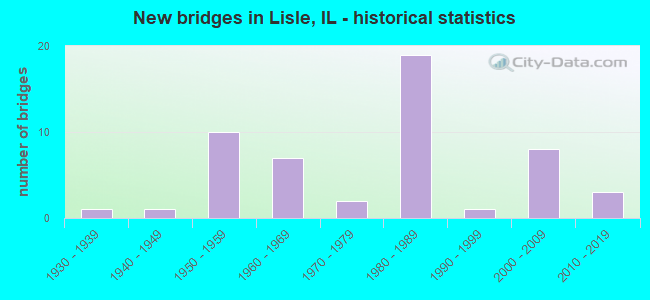
- New bridges - historical statistics
- 11930-1939
- 11940-1949
- 101950-1959
- 71960-1969
- 21970-1979
- 191980-1989
- 11990-1999
- 82000-2009
- 32010-2019

- Reconstructed bridges - Historical Statistics
- 11970-1979
- 51980-1989
- 21990-1999
- 12000-2009
- 12010-2019


- Bridge Condition - Deck
- 10.0%Very good
- 26.7%Good
- 43.3%Satisfactory
- 16.7%Fair
- 3.3%Serious

- Bridge Condition - Superstructure
- 18.2%Very good
- 27.3%Good
- 30.3%Satisfactory
- 21.2%Fair
- 3.0%Serious

- Bridge Condition - Substructure
- 18.2%Very good
- 54.5%Good
- 24.2%Satisfactory
- 3.0%Fair

- Bridge Condition - Channel
- 5.3%Excellent
- 10.5%Very good
- 42.1%Good
- 10.5%Satisfactory
- 26.3%Fair
- 5.3%Poor

- Bridge Condition - Culverts
- 33.3%Good
- 33.3%Satisfactory
- 33.3%Fair
Find on map >> Show street view
Structure Number: 220033, Location: 0.5 M S I-88 (Lat: 41.801000, Lng: -88.077519), Route carried "on" structure: US 34, Year Built: 1960, Year Reconstructed: 2010, Status: Open, Structure Length: 4.67m (15.32ft), Average Daily Traffic: 21,600 (year 2021), Truck Traffic: 5%, Average Future Daily Traffic: 29,855 (year 2032), Design Load: HS 20, Features Intersected: IL 53
Minimum Vertical Clearance: 30+ m (98+ ft), Kilometerpoint: 317.032, Lanes on structure: 4, Lanes under structure: 4, Base Highway Network: Yes, Owner: State Highway Agency, Approaching Roadway Width: 16.8m (55.1ft), Skew: 30 degrees, Material/Design: Steel continuous, Design/Construction: Stringer/Multi-beam, Number Of Spans In Main Unit: 3, Length of Maximum Span: 20.3m (66.6ft), Curb or Sidewalk Widths: Left: 1.5m (4.9ft), Right: 1.5m (4.9ft), Curb-To-Curb Width: 16.8m (55.1ft), Out-to-Out Width: 22.1m (72.5ft)
Condition: Deck: Good, Superstructure: Fair, Substructure: Good, Operating Rating: 72.6 metric tons, Method Used To Determine Operating Rating: Load Factor (LF) rating reported by rating factor (RF) method using MS18 loading, Inventory Rating: 43.4 metric tons, Method Used To Determine Inventory Rating: Load Factor (LF) rating reported by rating factor (RF) method using MS18 loading, Structural Evaluation: Somewhat better than minimum adequacy, Deck Geometry: Somewhat better than minimum adequacy, Underclear: High priority of corrective action, Approach Roadway Alignment: Equal to present desirable criteria, Length Of Structure Improvement: 4.66m (15.29ft), Designated Inspection Frequency: Every 24 months, Inspection Date: August 2021, Bridge Improvement Cost: $202,000, Roadway Improvement Cost: $10,000, Total Project Cost: $242,000, Deck Structure Type: Concrete Cast-file-Place, Wearing Surface/Protective System: Deck Protection: Epoxy Coated Reinforcing
Find on map >> Show street view
Structure Number: 220034, Location: 0.25 M E OF IL 53 (Lat: 41.801875, Lng: -88.068608), Route carried "on" structure: US 34, Year Built: 1968, Year Reconstructed: 1998, Status: Open, Structure Length: 0.98m (3.22ft), Average Daily Traffic: 21,600 (year 2021), Truck Traffic: 5%, Average Future Daily Traffic: 29,855 (year 2032), Design Load: HS 20, Features Intersected: ST JOSEPH CREEK
Minimum Vertical Clearance: 30+ m (98+ ft), Kilometerpoint: 317.821, Lanes on structure: 4, Base Highway Network: Yes, Owner: State Highway Agency, Approaching Roadway Width: 18.3m (60.0ft), Skew: 20 degrees, Material/Design: Concrete, Design/Construction: Slab, Number Of Spans In Main Unit: 1, Length of Maximum Span: 9.1m (29.9ft), Curb or Sidewalk Widths: Left: 1.5m (4.9ft), Right: 1.5m (4.9ft), Curb-To-Curb Width: 18.3m (60.0ft), Out-to-Out Width: 21.9m (71.9ft)
Condition: Deck: Fair, Superstructure: Fair, Substructure: Satisfactory, Channel: Fair, Operating Rating: 64.2 metric tons, Method Used To Determine Operating Rating: Load Factor (LF) rating reported by rating factor (RF) method using MS18 loading, Inventory Rating: 38.2 metric tons, Method Used To Determine Inventory Rating: Load Factor (LF) rating reported by rating factor (RF) method using MS18 loading, Structural Evaluation: Somewhat better than minimum adequacy, Deck Geometry: Somewhat better than minimum adequacy, Waterway Adequacy: Better than present minimum criteria, Approach Roadway Alignment: Better than present minimum criteria, Designated Inspection Frequency: Every 24 months, Other Special Inspection Frequency: Every 24 months, Inspection Date: August 2021, Other Special Inspection Date: August 2021, Deck Structure Type: Concrete Cast-file-Place, Wearing Surface/Protective System: Wearing Surface: Latex Concrete
Find on map >> Show street view
Structure Number: 220078, Location: 0.38 M N OF I-88 (Lat: 41.816592, Lng: -88.072428), Route carried "on" structure: State highway 53, Year Built: 1958, Year Reconstructed: 1992, Status: Open, Structure Length: 3.09m (10.14ft), Average Daily Traffic: 20,300 (year 2021), Truck Traffic: 4%, Average Future Daily Traffic: 15,095 (year 2032), Design Load: HS 20, Features Intersected: E BR DU PAGE RIVER
Minimum Vertical Clearance: 30+ m (98+ ft), Kilometerpoint: 82.284, Lanes on structure: 2, Base Highway Network: Yes, Owner: State Highway Agency, Approaching Roadway Width: 11.3m (37.1ft), Skew: 3 degrees, Material/Design: Steel continuous, Design/Construction: Stringer/Multi-beam, Number Of Spans In Main Unit: 3, Length of Maximum Span: 11.4m (37.4ft), Curb-To-Curb Width: 11.3m (37.1ft), Out-to-Out Width: 12.3m (40.4ft)
Condition: Deck: Satisfactory, Superstructure: Satisfactory, Substructure: Good, Channel: Fair, Operating Rating: 65.4 metric tons, Method Used To Determine Operating Rating: Load Factor (LF) rating reported by rating factor (RF) method using MS18 loading, Inventory Rating: 35.6 metric tons, Method Used To Determine Inventory Rating: Load Factor (LF) rating reported by rating factor (RF) method using MS18 loading, Structural Evaluation: Equal to present minimum criteria, Deck Geometry: Equal to present minimum criteria, Waterway Adequacy: Better than present minimum criteria, Approach Roadway Alignment: Better than present minimum criteria, Designated Inspection Frequency: Every 24 months, Inspection Date: October 2021, Deck Structure Type: Concrete Cast-file-Place, Wearing Surface/Protective System: Deck Protection: Epoxy Coated Reinforcing
Find on map >> Show street view
Structure Number: 220079, Location: 0.38 M N OF I-88 (Lat: 41.816483, Lng: -88.072525), Route carried "on" structure: State highway 53, Year Built: 1958, Year Reconstructed: 1992, Status: Open, Structure Length: 3.09m (10.14ft), Average Daily Traffic: 20,300 (year 2021), Truck Traffic: 4%, Average Future Daily Traffic: 15,095 (year 2032), Design Load: HS 20, Features Intersected: E BR DU PAGE RIVER
Minimum Vertical Clearance: 30+ m (98+ ft), Kilometerpoint: 82.267, Lanes on structure: 2, Base Highway Network: Yes, Owner: State Highway Agency, Approaching Roadway Width: 11.0m (36.1ft), Skew: 3 degrees, Material/Design: Steel continuous, Design/Construction: Stringer/Multi-beam, Number Of Spans In Main Unit: 3, Length of Maximum Span: 11.3m (37.1ft), Curb-To-Curb Width: 11.0m (36.1ft), Out-to-Out Width: 11.9m (39.0ft)
Condition: Deck: Good, Superstructure: Satisfactory, Substructure: Good, Channel: Fair, Operating Rating: 68.7 metric tons, Method Used To Determine Operating Rating: Load Factor (LF) rating reported by rating factor (RF) method using MS18 loading, Inventory Rating: 37.3 metric tons, Method Used To Determine Inventory Rating: Load Factor (LF) rating reported by rating factor (RF) method using MS18 loading, Structural Evaluation: Equal to present minimum criteria, Deck Geometry: Equal to present minimum criteria, Waterway Adequacy: Better than present minimum criteria, Approach Roadway Alignment: Better than present minimum criteria, Designated Inspection Frequency: Every 24 months, Inspection Date: October 2021, Deck Structure Type: Concrete Cast-file-Place, Wearing Surface/Protective System: Deck Protection: Epoxy Coated Reinforcing
Find on map >> Show street view
Structure Number: 22008, Location: 0.24 M N I-88 (Lat: 41.814872, Lng: -88.073506), Route carried "on" structure: State highway 53, Year Built: 1959, Year Reconstructed: 1992, Status: Open, Structure Length: 1.10m (3.61ft), Average Daily Traffic: 20,300 (year 2021), Truck Traffic: 4%, Average Future Daily Traffic: 15,095 (year 2032), Design Load: HS 20, Features Intersected: MORTON ARBORETUM DR
Minimum Vertical Clearance: 30+ m (98+ ft), Kilometerpoint: 82.026, Lanes on structure: 2, Base Highway Network: Yes, Owner: State Highway Agency, Approaching Roadway Width: 9.1m (29.9ft), Material/Design: Concrete, Design/Construction: Frame, Number Of Spans In Main Unit: 1, Length of Maximum Span: 10.1m (33.1ft), Curb-To-Curb Width: 16.4m (53.8ft), Out-to-Out Width: 17.4m (57.1ft)
Condition: Superstructure: Fair, Substructure: Good, Operating Rating: 46.7 metric tons, Method Used To Determine Operating Rating: Load Factor (LF) rating reported by rating factor (RF) method using MS18 loading, Inventory Rating: 27.9 metric tons, Method Used To Determine Inventory Rating: Load Factor (LF) rating reported by rating factor (RF) method using MS18 loading, Structural Evaluation: Somewhat better than minimum adequacy, Deck Geometry: Superior to present desirable criteria, Approach Roadway Alignment: Equal to present desirable criteria, Designated Inspection Frequency: Every 24 months, Inspection Date: January 2021, Deck Structure Type: Concrete Cast-file-Place, Wearing Surface/Protective System: Wearing Surface: Other
Find on map >> Show street view
Structure Number: 220081, Location: 0.24 M N I-88 (Lat: 41.814744, Lng: -88.073558), Route carried "on" structure: State highway 53, Year Built: 1959, Year Reconstructed: 1992, Status: Open, Structure Length: 1.10m (3.61ft), Average Daily Traffic: 20,300 (year 2021), Truck Traffic: 4%, Average Future Daily Traffic: 15,095 (year 2032), Design Load: HS 20, Features Intersected: MORTON ARBORETUM DR
Minimum Vertical Clearance: 30+ m (98+ ft), Kilometerpoint: 82.010, Lanes on structure: 2, Base Highway Network: Yes, Owner: State Highway Agency, Approaching Roadway Width: 9.1m (29.9ft), Material/Design: Concrete, Design/Construction: Frame, Number Of Spans In Main Unit: 1, Length of Maximum Span: 10.1m (33.1ft), Curb-To-Curb Width: 16.4m (53.8ft), Out-to-Out Width: 17.4m (57.1ft)
Condition: Superstructure: Satisfactory, Substructure: Satisfactory, Operating Rating: 42.1 metric tons, Method Used To Determine Operating Rating: Load Factor (LF) rating reported by rating factor (RF) method using MS18 loading, Inventory Rating: 25.3 metric tons, Method Used To Determine Inventory Rating: Load Factor (LF) rating reported by rating factor (RF) method using MS18 loading, Structural Evaluation: Equal to present minimum criteria, Deck Geometry: Superior to present desirable criteria, Approach Roadway Alignment: Equal to present desirable criteria, Designated Inspection Frequency: Every 24 months, Inspection Date: January 2021, Deck Structure Type: Concrete Cast-file-Place, Wearing Surface/Protective System: Wearing Surface: Other
Find on map >> Show street view
Structure Number: 220148, Location: 0.2 M W IL 53 (Lat: 41.800572, Lng: -88.081794), Route carried "on" structure: US 34, Year Built: 1982, Status: Open, Structure Length: 2.65m (8.69ft), Average Daily Traffic: 23,400 (year 2021), Truck Traffic: 5%, Average Future Daily Traffic: 37,542 (year 2032), Design Load: HS 20, Features Intersected: E BR DU PAGE RIVER
Minimum Vertical Clearance: 30+ m (98+ ft), Kilometerpoint: 316.726, Lanes on structure: 4, Base Highway Network: Yes, Owner: State Highway Agency, Approaching Roadway Width: 16.8m (55.1ft), Skew: 20 degrees, Material/Design: Concrete continuous, Design/Construction: Slab, Number Of Spans In Main Unit: 3, Length of Maximum Span: 9.7m (31.8ft), Curb or Sidewalk Widths: Left: 1.8m (5.9ft), Right: 1.8m (5.9ft), Curb-To-Curb Width: 18.0m (59.1ft), Out-to-Out Width: 22.2m (72.8ft)
Condition: Deck: Fair, Superstructure: Fair, Substructure: Good, Channel: Fair, Operating Rating: 52.5 metric tons, Method Used To Determine Operating Rating: Load Factor (LF) rating reported by rating factor (RF) method using MS18 loading, Inventory Rating: 31.4 metric tons, Method Used To Determine Inventory Rating: Load Factor (LF) rating reported by rating factor (RF) method using MS18 loading, Structural Evaluation: Somewhat better than minimum adequacy, Deck Geometry: Somewhat better than minimum adequacy, Waterway Adequacy: Equal to present minimum criteria, Approach Roadway Alignment: Equal to present desirable criteria, Designated Inspection Frequency: Every 24 months, Inspection Date: October 2021, Deck Structure Type: Concrete Cast-file-Place, Wearing Surface/Protective System: Wearing Surface: Other, Deck Protection: Epoxy Coated Reinforcing
Find on map >> Show street view
Structure Number: 223003, Location: 0.3 MI W IL 53 (Lat: 41.808486, Lng: -88.081075), Route carried "on" structure: Other road , Year Built: 1946, Year Reconstructed: 1981, Status: Posted for load, Structure Length: 1.69m (5.54ft), Average Daily Traffic: 12,600 (year 2020), Truck Traffic: 6%, Average Future Daily Traffic: 19,049 (year 2032), Design Load: HS 20, Features Intersected: E.BRANCH DU PAGE RV, Facility Carried by Structure: WARRENVILLE RD
Minimum Vertical Clearance: 30+ m (98+ ft), Kilometerpoint: 9.527, Lanes on structure: 4, Base Highway Network: Yes, Owner: County Highway Agency, Approaching Roadway Width: 19.5m (64.0ft), Material/Design: Prestressed concrete, Design/Construction: Box Beam or Girders - Multiple, Number Of Spans In Main Unit: 1, Length of Maximum Span: 15.7m (51.5ft), Curb-To-Curb Width: 19.3m (63.3ft), Out-to-Out Width: 19.5m (64.0ft)
Condition: Deck: Serious, Superstructure: Serious, Substructure: Fair, Channel: Satisfactory, Operating Rating: 18.1 metric tons, Method Used To Determine Operating Rating: Load Factor (LF) rating reported by rating factor (RF) method using MS18 loading, Inventory Rating: 10.7 metric tons, Method Used To Determine Inventory Rating: Load Factor (LF) rating reported by rating factor (RF) method using MS18 loading, Structural Evaluation: High priority of corrective action, Deck Geometry: Equal to present minimum criteria, Waterway Adequacy: Equal to present desirable criteria, Approach Roadway Alignment: Equal to present desirable criteria, Bridge Posting: Required (Relationship of Operating Rating to Maximum Legal Load: 30.0 - 39.9% below), Designated Inspection Frequency: Every 24 months, Other Special Inspection Frequency: Every 12 months, Inspection Date: September 2021, Other Special Inspection Date: September 2021, Deck Structure Type: Concrete Precast Panels, Wearing Surface/Protective System: Wearing Surface: Bituminous, Membrane: Built-up
Find on map >> Show street view
Structure Number: 223017, Location: 0.3 MI S OF US 34 (Lat: 41.794906, Lng: -88.090919), Route carried "on" structure: Other road , Year Built: 1967, Status: Open, Structure Length: 5.90m (19.36ft), Average Daily Traffic: 10,150 (year 2020), Truck Traffic: 6%, Average Future Daily Traffic: 10,137 (year 2032), Design Load: HS 20, Features Intersected: BN RR, Facility Carried by Structure: YACKLEY AVE
Minimum Vertical Clearance: 30+ m (98+ ft), Kilometerpoint: 1.481, Lanes on structure: 4, Owner: County Highway Agency, Approaching Roadway Width: 16.2m (53.1ft), Skew: 31 degrees, Material/Design: Prestressed concrete, Design/Construction: Stringer/Multi-beam, Number Of Spans In Main Unit: 3, Length of Maximum Span: 24.4m (80.1ft), Curb or Sidewalk Widths: Left: 1.5m (4.9ft), Right: 0.0m, Curb-To-Curb Width: 16.2m (53.1ft), Out-to-Out Width: 21.0m (68.9ft)
Condition: Deck: Satisfactory, Superstructure: Good, Substructure: Good, Operating Rating: 57.0 metric tons, Method Used To Determine Operating Rating: Load Factor (LF) rating reported by rating factor (RF) method using MS18 loading, Inventory Rating: 34.0 metric tons, Method Used To Determine Inventory Rating: Load Factor (LF) rating reported by rating factor (RF) method using MS18 loading, Structural Evaluation: Better than present minimum criteria, Deck Geometry: Meets minimum limits, Underclear: Better than present minimum criteria, Approach Roadway Alignment: Equal to present desirable criteria, Designated Inspection Frequency: Every 24 months, Inspection Date: October 2020, Deck Structure Type: Concrete Cast-file-Place, Wearing Surface/Protective System: Wearing Surface: Latex Concrete
Find on map >> Show street view
Structure Number: 223038, Location: .1 M W ILL 53 (Lat: 41.785794, Lng: -88.079233), Route carried "on" structure: Other road , Year Built: 1973, Year Reconstructed: 2009, Status: Open, Structure Length: 3.60m (11.81ft), Average Daily Traffic: 16,000 (year 2020), Truck Traffic: 4%, Average Future Daily Traffic: 27,182 (year 2032), Design Load: HS 25 or greater, Features Intersected: E. BR DU PAGE RIVER, Facility Carried by Structure: MAPLE AVE
Minimum Vertical Clearance: 30+ m (98+ ft), Kilometerpoint: 5.987, Lanes on structure: 4, Base Highway Network: Yes, Owner: County Highway Agency, Approaching Roadway Width: 15.8m (51.8ft), Skew: 30 degrees, Material/Design: Steel continuous, Design/Construction: Stringer/Multi-beam, Number Of Spans In Main Unit: 2, Length of Maximum Span: 17.4m (57.1ft), Curb or Sidewalk Widths: Left: 1.5m (4.9ft), Right: 4.3m (14.1ft), Curb-To-Curb Width: 15.8m (51.8ft), Out-to-Out Width: 23.7m (77.8ft)
Condition: Deck: Good, Superstructure: Very good, Substructure: Very good, Channel: Good, Operating Rating: 56.4 metric tons, Method Used To Determine Operating Rating: Load Factor (LF) rating reported by rating factor (RF) method using MS18 loading, Inventory Rating: 40.2 metric tons, Method Used To Determine Inventory Rating: Load Factor (LF) rating reported by rating factor (RF) method using MS18 loading, Structural Evaluation: Equal to present desirable criteria, Deck Geometry: Meets minimum limits, Waterway Adequacy: Superior to present desirable criteria, Approach Roadway Alignment: Equal to present desirable criteria, Designated Inspection Frequency: Every 48 months, Inspection Date: September 2021, Deck Structure Type: Concrete Cast-file-Place, Wearing Surface/Protective System: Deck Protection: Epoxy Coated Reinforcing
Find on map >> Show street view
Structure Number: 223054, Location: 0.2 M N OF US 34 (Lat: 41.803036, Lng: -88.077744), Route carried "on" structure: State highway 53, Year Built: 2013, Status: Open, Structure Length: 0.92m (3.02ft), Average Daily Traffic: 19,700 (year 2021), Truck Traffic: 7%, Average Future Daily Traffic: 25,288 (year 2032), Design Load: HS 20, Features Intersected: ST JOSEPH CREEK
Minimum Vertical Clearance: 30+ m (98+ ft), Kilometerpoint: 80.658, Lanes on structure: 4, Base Highway Network: Yes, Owner: State Highway Agency, Approaching Roadway Width: 16.8m (55.1ft), Skew: 2 degrees, Material/Design: Concrete, Design/Construction: Frame, Number Of Spans In Main Unit: 1, Length of Maximum Span: 8.8m (28.9ft), Curb or Sidewalk Widths: Left: 1.5m (4.9ft), Right: 1.5m (4.9ft), Curb-To-Curb Width: 19.5m (64.0ft), Out-to-Out Width: 21.3m (69.9ft)
Condition: Superstructure: Good, Substructure: Very good, Channel: Fair, Operating Rating: 54.1 metric tons, Method Used To Determine Operating Rating: Assigned rating based on Load Factor Design (LFD) reported by rating factor (RF) using MS18 loading, Inventory Rating: 32.4 metric tons, Method Used To Determine Inventory Rating: Assigned rating based on Load Factor Design (LFD) reported by rating factor (RF) using MS18 loading, Structural Evaluation: Better than present minimum criteria, Deck Geometry: Better than present minimum criteria, Waterway Adequacy: Equal to present desirable criteria, Approach Roadway Alignment: Equal to present desirable criteria, Designated Inspection Frequency: Every 48 months, Inspection Date: August 2019
Find on map >> Show street view
Structure Number: 225001, Location: 0.4M.S.OF OGDEN AVE. (Lat: 41.793400, Lng: -88.090836), Route carried "on" structure: Other road , Year Built: 1967, Year Reconstructed: 1985, Status: Open, Structure Length: 0.74m (2.43ft), Average Daily Traffic: 10,150 (year 2020), Truck Traffic: 6%, Average Future Daily Traffic: 20,275 (year 2032), Design Load: HS 20, Features Intersected: ROTT CREEK, Facility Carried by Structure: YACKLEY AVE
Minimum Vertical Clearance: 30+ m (98+ ft), Kilometerpoint: 1.641, Lanes on structure: 4, Owner: County Highway Agency, Approaching Roadway Width: 18.3m (60.0ft), Skew: 20 degrees, Material/Design: Concrete continuous, Design/Construction: Culvert, Number Of Spans In Main Unit: 2, Length of Maximum Span: 3.6m (11.8ft), Curb or Sidewalk Widths: Left: 0.0m, Right: 3.7m (12.1ft)
Condition: Channel: Poor, Culverts: Fair, Operating Rating: 40.5 metric tons, Method Used To Determine Operating Rating: Load Factor (LF) rating reported by rating factor (RF) method using MS18 loading, Inventory Rating: 24.3 metric tons, Method Used To Determine Inventory Rating: Load Factor (LF) rating reported by rating factor (RF) method using MS18 loading, Structural Evaluation: Somewhat better than minimum adequacy, Waterway Adequacy: Equal to present minimum criteria, Approach Roadway Alignment: Equal to present desirable criteria, Designated Inspection Frequency: Every 24 months, Inspection Date: September 2020
Find on map >> Show street view
Structure Number: 226649, Location: 800' W IL 53 (Lat: 41.792806, Lng: -88.078992), Route carried "on" structure: City street , Year Built: 2011, Status: Open, Structure Length: 3.05m (10.01ft), Average Daily Traffic: 1,400 (year 2020), Truck Traffic: 4%, Average Future Daily Traffic: 4,902 (year 2032), Design Load: HS 25 or greater, Features Intersected: E BRANCH DUPAGE RIV, Facility Carried by Structure: SHORT STREET
Minimum Vertical Clearance: 30+ m (98+ ft), Kilometerpoint: 0.740, Lanes on structure: 2, Owner: City or Municipal Highway Agency, Approaching Roadway Width: 8.2m (26.9ft), Material/Design: Concrete continuous, Design/Construction: Slab, Number Of Spans In Main Unit: 3, Length of Maximum Span: 12.8m (42.0ft), Curb or Sidewalk Widths: Left: 2.4m (7.9ft), Right: 1.7m (5.6ft), Curb-To-Curb Width: 8.2m (26.9ft), Out-to-Out Width: 13.3m (43.6ft)
Condition: Deck: Good, Superstructure: Good, Substructure: Very good, Channel: Excellent, Operating Rating: 42.1 metric tons, Method Used To Determine Operating Rating: Assigned ratings based on Load and Resistance Factor Design (LRFD) reported by rating factor (RF) using HL93 loadings, Inventory Rating: 32.4 metric tons, Method Used To Determine Inventory Rating: Assigned ratings based on Load and Resistance Factor Design (LRFD) reported by rating factor (RF) using HL93 loadings, Structural Evaluation: Better than present minimum criteria, Deck Geometry: Meets minimum limits, Waterway Adequacy: Equal to present desirable criteria, Approach Roadway Alignment: Equal to present desirable criteria, Designated Inspection Frequency: Every 48 months, Inspection Date: October 2020, Deck Structure Type: Concrete Cast-file-Place, Wearing Surface/Protective System: Deck Protection: Epoxy Coated Reinforcing
Find on map >> Show street view
Structure Number: 226651, Location: 0.2 MI W OF MAIN ST (Lat: 41.803525, Lng: -88.071917), Route carried "on" structure: City street , Year Built: 1967, Status: Open, Structure Length: 1.49m (4.89ft), Average Daily Traffic: 325 (year 2020), Truck Traffic: 13%, Average Future Daily Traffic: 344 (year 2032), Features Intersected: ST.JOSEPH CREEK, Facility Carried by Structure: CENTER AVE
Minimum Vertical Clearance: 30+ m (98+ ft), Kilometerpoint: 0.290, Lanes on structure: 2, Owner: City or Municipal Highway Agency, Approaching Roadway Width: 6.1m (20.0ft), Skew: 4 degrees, Material/Design: Prestressed concrete, Design/Construction: Box Beam or Girders - Multiple, Number Of Spans In Main Unit: 1, Length of Maximum Span: 14.0m (45.9ft), Curb-To-Curb Width: 6.2m (20.3ft), Out-to-Out Width: 8.2m (26.9ft)
Condition: Deck: Fair, Superstructure: Fair, Substructure: Good, Channel: Good, Operating Rating: 60.3 metric tons, Method Used To Determine Operating Rating: Load Factor (LF) rating reported by rating factor (RF) method using MS18 loading, Inventory Rating: 37.3 metric tons, Method Used To Determine Inventory Rating: Load Factor (LF) rating reported by rating factor (RF) method using MS18 loading, Structural Evaluation: Somewhat better than minimum adequacy, Deck Geometry: Meets minimum limits, Waterway Adequacy: Equal to present desirable criteria, Approach Roadway Alignment: Equal to present minimum criteria, Designated Inspection Frequency: Every 24 months, Inspection Date: October 2020, Deck Structure Type: Concrete Precast Panels, Wearing Surface/Protective System: Wearing Surface: Bituminous
Find on map >> Show street view
Structure Number: 226652, Location: 600 FT N OF US 34 (Lat: 41.802050, Lng: -88.080231), Route carried "on" structure: City street , Year Built: 1967, Status: Open, Structure Length: 1.49m (4.89ft), Average Daily Traffic: 75 (year 2016), Truck Traffic: 15%, Average Future Daily Traffic: 344 (year 2032), Features Intersected: ST.JOSEPH CREEK, Facility Carried by Structure: DOMOULIN AVE
Minimum Vertical Clearance: 30+ m (98+ ft), Kilometerpoint: 0.306, Lanes on structure: 2, Owner: City or Municipal Highway Agency, Approaching Roadway Width: 6.1m (20.0ft), Skew: 4 degrees, Material/Design: Prestressed concrete, Design/Construction: Box Beam or Girders - Multiple, Number Of Spans In Main Unit: 1, Length of Maximum Span: 14.3m (46.9ft), Curb-To-Curb Width: 6.2m (20.3ft), Out-to-Out Width: 8.2m (26.9ft)
Condition: Deck: Fair, Superstructure: Fair, Substructure: Good, Channel: Satisfactory, Operating Rating: 57.0 metric tons, Method Used To Determine Operating Rating: Load Factor (LF) rating reported by rating factor (RF) method using MS18 loading, Inventory Rating: 34.3 metric tons, Method Used To Determine Inventory Rating: Load Factor (LF) rating reported by rating factor (RF) method using MS18 loading, Structural Evaluation: Somewhat better than minimum adequacy, Deck Geometry: Somewhat better than minimum adequacy, Waterway Adequacy: Equal to present desirable criteria, Approach Roadway Alignment: Somewhat better than minimum adequacy, Designated Inspection Frequency: Every 24 months, Inspection Date: October 2020, Deck Structure Type: Concrete Precast Panels, Wearing Surface/Protective System: Wearing Surface: Bituminous
Find on map >> Show street view
Structure Number: 226655, Location: .30 M N OF OGDEN AV (Lat: 41.805769, Lng: -88.074300), Route carried "on" structure: Other road , Year Built: 1991, Status: Open, Structure Length: 2.30m (7.55ft), Average Daily Traffic: 1,800 (year 2020), Truck Traffic: 8%, Average Future Daily Traffic: 3,788 (year 2032), Design Load: HS 20+Mod, Features Intersected: ST JOESEPH CREEK, Facility Carried by Structure: MAIN ST
Minimum Vertical Clearance: 30+ m (98+ ft), Kilometerpoint: 0.370, Lanes on structure: 3, Owner: City or Municipal Highway Agency, Approaching Roadway Width: 12.2m (40.0ft), Material/Design: Concrete continuous, Design/Construction: Slab, Number Of Spans In Main Unit: 3, Length of Maximum Span: 8.5m (27.9ft), Curb or Sidewalk Widths: Left: 2.1m (6.9ft), Right: 2.1m (6.9ft), Curb-To-Curb Width: 12.2m (40.0ft), Out-to-Out Width: 17.1m (56.1ft)
Condition: Deck: Very good, Superstructure: Very good, Substructure: Very good, Channel: Very good, Operating Rating: 53.8 metric tons, Method Used To Determine Operating Rating: Assigned rating based on Load Factor Design (LFD) reported by rating factor (RF) using MS18 loading, Inventory Rating: 32.4 metric tons, Method Used To Determine Inventory Rating: Assigned rating based on Load Factor Design (LFD) reported by rating factor (RF) using MS18 loading, Structural Evaluation: Equal to present desirable criteria, Deck Geometry: Meets minimum limits, Waterway Adequacy: Superior to present desirable criteria, Approach Roadway Alignment: Equal to present desirable criteria, Designated Inspection Frequency: Every 48 months, Inspection Date: October 2020, Deck Structure Type: Concrete Cast-file-Place, Wearing Surface/Protective System: Wearing Surface: Bituminous, Deck Protection: Epoxy Coated Reinforcing
Find on map >> Show street view
Structure Number: 226656, Location: 900'W OF IL53 (Lat: 41.797364, Lng: -88.080658), Route carried "on" structure: Other road , Year Built: 1989, Year Reconstructed: 1999, Status: Open, Structure Length: 3.35m (10.99ft), Average Daily Traffic: 1,100 (year 2020), Truck Traffic: 6%, Average Future Daily Traffic: 2,618 (year 2032), Design Load: HS 20, Features Intersected: E BRANCH DUPAGE R, Facility Carried by Structure: BURLINGTON AV
Minimum Vertical Clearance: 30+ m (98+ ft), Kilometerpoint: 0.869, Lanes on structure: 2, Owner: City or Municipal Highway Agency, Approaching Roadway Width: 9.1m (29.9ft), Material/Design: Steel continuous, Design/Construction: Stringer/Multi-beam, Number Of Spans In Main Unit: 3, Length of Maximum Span: 13.7m (44.9ft), Curb or Sidewalk Widths: Left: 1.5m (4.9ft), Right: 1.5m (4.9ft), Curb-To-Curb Width: 9.1m (29.9ft), Out-to-Out Width: 12.8m (42.0ft)
Condition: Deck: Very good, Superstructure: Very good, Substructure: Very good, Channel: Good, Operating Rating: 44.1 metric tons, Method Used To Determine Operating Rating: Load Factor (LF) rating reported by rating factor (RF) method using MS18 loading, Inventory Rating: 32.4 metric tons, Method Used To Determine Inventory Rating: Load Factor (LF) rating reported by rating factor (RF) method using MS18 loading, Structural Evaluation: Equal to present desirable criteria, Deck Geometry: Somewhat better than minimum adequacy, Waterway Adequacy: Superior to present desirable criteria, Approach Roadway Alignment: Superior to present desirable criteria, Designated Inspection Frequency: Every 48 months, Inspection Date: October 2020, Deck Structure Type: Concrete Cast-file-Place, Wearing Surface/Protective System: Deck Protection: Epoxy Coated Reinforcing
Find on map >> Show street view
Structure Number: 226657, Location: N.OF UNIVERSITY LA. (Lat: 41.793672, Lng: -88.087417), Route carried "on" structure: City street , Year Built: 1978, Status: Open, Structure Length: 0.80m (2.62ft), Average Daily Traffic: 250 (year 2020), Truck Traffic: 19%, Average Future Daily Traffic: 111 (year 2032), Design Load: HS 20, Features Intersected: ROTT CREEK, Facility Carried by Structure: VARSITY DR.
Minimum Vertical Clearance: 30+ m (98+ ft), Kilometerpoint: 0.080, Lanes on structure: 2, Owner: City or Municipal Highway Agency, Approaching Roadway Width: 9.1m (29.9ft), Material/Design: Concrete continuous, Design/Construction: Culvert, Number Of Spans In Main Unit: 2, Length of Maximum Span: 3.9m (12.8ft), Curb-To-Curb Width: 9.1m (29.9ft), Out-to-Out Width: 9.8m (32.2ft)
Condition: Channel: Good, Culverts: Satisfactory, Operating Rating: 54.1 metric tons, Method Used To Determine Operating Rating: Field evaluation and documented engineering judgment, Inventory Rating: 32.4 metric tons, Method Used To Determine Inventory Rating: Field evaluation and documented engineering judgment, Structural Evaluation: Equal to present minimum criteria, Deck Geometry: Equal to present minimum criteria, Waterway Adequacy: Equal to present desirable criteria, Approach Roadway Alignment: Equal to present desirable criteria, Designated Inspection Frequency: Every 24 months, Inspection Date: October 2020, Deck Structure Type: Concrete Cast-file-Place
Find on map >> Show street view
Structure Number: 226658, Location: W.OF LEASK LANE (Lat: 41.814036, Lng: -88.095239), Route carried "on" structure: City street , Year Built: 1980, Status: Open, Structure Length: 1.07m (3.51ft), Average Daily Traffic: 400 (year 2020), Truck Traffic: 14%, Average Future Daily Traffic: 121 (year 2032), Design Load: HS 20, Features Intersected: WILLOW WAY CREEK, Facility Carried by Structure: PEBBLE CREEK DR.
Minimum Vertical Clearance: 30+ m (98+ ft), Kilometerpoint: 0.917, Lanes on structure: 2, Owner: City or Municipal Highway Agency, Approaching Roadway Width: 8.2m (26.9ft), Material/Design: Prestressed concrete, Design/Construction: Box Beam or Girders - Multiple, Number Of Spans In Main Unit: 1, Length of Maximum Span: 10.0m (32.8ft), Curb or Sidewalk Widths: Left: 1.4m (4.6ft), Right: 1.4m (4.6ft), Curb-To-Curb Width: 8.2m (26.9ft), Out-to-Out Width: 11.0m (36.1ft)
Condition: Deck: Fair, Superstructure: Fair, Substructure: Satisfactory, Channel: Good, Operating Rating: 54.1 metric tons, Method Used To Determine Operating Rating: Field evaluation and documented engineering judgment, Inventory Rating: 32.4 metric tons, Method Used To Determine Inventory Rating: Field evaluation and documented engineering judgment, Structural Evaluation: Somewhat better than minimum adequacy, Deck Geometry: Somewhat better than minimum adequacy, Waterway Adequacy: Superior to present desirable criteria, Approach Roadway Alignment: Equal to present minimum criteria, Designated Inspection Frequency: Every 24 months, Inspection Date: October 2020, Deck Structure Type: Concrete Precast Panels, Wearing Surface/Protective System: Wearing Surface: Bituminous, Membrane: Built-up
Find on map >> Show street view
Structure Number: 226659, Location: W.OF LEASK LANE (Lat: 41.817872, Lng: -88.096281), Route carried "on" structure: City street , Year Built: 1989, Status: Open, Structure Length: 0.77m (2.53ft), Average Daily Traffic: 175 (year 2020), Truck Traffic: 6%, Average Future Daily Traffic: 121 (year 2032), Design Load: HS 20, Features Intersected: WILLOW WAY CR., Facility Carried by Structure: REGENCY WOODS DR.
Minimum Vertical Clearance: 30+ m (98+ ft), Kilometerpoint: 0.386, Lanes on structure: 2, Owner: City or Municipal Highway Agency, Approaching Roadway Width: 8.2m (26.9ft), Skew: 3 degrees, Material/Design: Concrete, Design/Construction: Culvert, Number Of Spans In Main Unit: 3, Length of Maximum Span: 2.0m (6.6ft), Curb or Sidewalk Widths: Left: 1.5m (4.9ft), Right: 0.0m
Condition: Channel: Good, Culverts: Good, Operating Rating: 54.1 metric tons, Method Used To Determine Operating Rating: Field evaluation and documented engineering judgment, Inventory Rating: 32.4 metric tons, Method Used To Determine Inventory Rating: Field evaluation and documented engineering judgment, Structural Evaluation: Better than present minimum criteria, Waterway Adequacy: Equal to present desirable criteria, Approach Roadway Alignment: Equal to present desirable criteria, Designated Inspection Frequency: Every 48 months, Inspection Date: October 2020
Find on map >> Show street view
Structure Number: 226663, Location: 0.4 MI W IL 53 (Lat: 41.777736, Lng: -88.078369), Route carried "on" structure: City street , Year Built: 2016, Status: Open, Structure Length: 3.20m (10.50ft), Average Daily Traffic: 3,800 (year 2020), Truck Traffic: 2%, Average Future Daily Traffic: 2,000 (year 2040), Design Load: HS 25 or greater, Features Intersected: E. Br. DuPage River, Facility Carried by Structure: Four Lakes Avenue
Minimum Vertical Clearance: 30+ m (98+ ft), Kilometerpoint: 0.756, Lanes on structure: 2, Owner: City or Municipal Highway Agency, Approaching Roadway Width: 9.1m (29.9ft), Material/Design: Concrete continuous, Design/Construction: Slab, Number Of Spans In Main Unit: 3, Length of Maximum Span: 11.7m (38.4ft), Curb or Sidewalk Widths: Left: 1.5m (4.9ft), Right: 1.5m (4.9ft), Curb-To-Curb Width: 9.1m (29.9ft), Out-to-Out Width: 12.8m (42.0ft)
Condition: Deck: Very good, Superstructure: Very good, Substructure: Very good, Channel: Very good, Operating Rating: 42.1 metric tons, Method Used To Determine Operating Rating: Assigned ratings based on Load and Resistance Factor Design (LRFD) reported by rating factor (RF) using HL93 loadings, Inventory Rating: 32.4 metric tons, Method Used To Determine Inventory Rating: Assigned ratings based on Load and Resistance Factor Design (LRFD) reported by rating factor (RF) using HL93 loadings, Structural Evaluation: Equal to present desirable criteria, Deck Geometry: Meets minimum limits, Waterway Adequacy: Superior to present desirable criteria, Approach Roadway Alignment: Equal to present desirable criteria, Designated Inspection Frequency: Every 48 months, Inspection Date: October 2020, Deck Structure Type: Concrete Cast-file-Place, Wearing Surface/Protective System: Deck Protection: Epoxy Coated Reinforcing
Find on map >> Show street view
Structure Number: 229803, Location: 0.1MI W OF IL 53 (Lat: 41.808158, Lng: -88.079217), Route carried "on" structure: Interstate 88, Year Built: 2006, Status: Open, Structure Length: 5.20m (17.06ft), Average Daily Traffic: 61,950 (year 2020), Truck Traffic: 22%, Average Future Daily Traffic: 314,000 (year 2035), Design Load: HS 20, Features Intersected: WARRENVILLE ROAD
Minimum Vertical Clearance: 30+ m (98+ ft), Kilometerpoint: 208.549, Lanes on structure: 4, Lanes under structure: 4, Base Highway Network: Yes, Toll: On toll road, Owner: State Toll Authority, Approaching Roadway Width: 22.7m (74.5ft), Skew: 4 degrees, Material/Design: Prestressed concrete, Design/Construction: Stringer/Multi-beam, Number Of Spans In Main Unit: 2, Number Of Approach Spans: 2, Length of Maximum Span: 28.4m (93.2ft), Curb-To-Curb Width: 22.7m (74.5ft), Out-to-Out Width: 23.6m (77.4ft)
Condition: Deck: Good, Superstructure: Good, Substructure: Good, Operating Rating: 60.9 metric tons, Method Used To Determine Operating Rating: Load Factor (LF) rating reported by rating factor (RF) method using MS18 loading, Inventory Rating: 36.6 metric tons, Method Used To Determine Inventory Rating: Load Factor (LF) rating reported by rating factor (RF) method using MS18 loading, Structural Evaluation: Better than present minimum criteria, Deck Geometry: Superior to present desirable criteria, Underclear: High priority of corrective action, Approach Roadway Alignment: Equal to present desirable criteria, Designated Inspection Frequency: Every 24 months, Inspection Date: September 2020, Deck Structure Type: Concrete Cast-file-Place, Wearing Surface/Protective System: Deck Protection: Epoxy Coated Reinforcing
Find on map >> Show street view
Structure Number: 229804, Location: 0.1MI W OF IL 53 (Lat: 41.808233, Lng: -88.079050), Route carried "on" structure: Interstate 88, Year Built: 2007, Status: Open, Structure Length: 5.20m (17.06ft), Average Daily Traffic: 61,950 (year 2020), Truck Traffic: 22%, Average Future Daily Traffic: 314,000 (year 2035), Design Load: HS 20, Features Intersected: WARRENVILLE ROAD
Minimum Vertical Clearance: 30+ m (98+ ft), Kilometerpoint: 208.565, Lanes on structure: 4, Lanes under structure: 4, Base Highway Network: Yes, Toll: On toll road, Owner: State Toll Authority, Approaching Roadway Width: 22.7m (74.5ft), Skew: 4 degrees, Material/Design: Prestressed concrete, Design/Construction: Stringer/Multi-beam, Number Of Spans In Main Unit: 2, Number Of Approach Spans: 2, Length of Maximum Span: 28.4m (93.2ft), Curb-To-Curb Width: 22.7m (74.5ft), Out-to-Out Width: 23.6m (77.4ft)
Condition: Deck: Satisfactory, Superstructure: Good, Substructure: Good, Operating Rating: 60.9 metric tons, Method Used To Determine Operating Rating: Load Factor (LF) rating reported by rating factor (RF) method using MS18 loading, Inventory Rating: 36.6 metric tons, Method Used To Determine Inventory Rating: Load Factor (LF) rating reported by rating factor (RF) method using MS18 loading, Structural Evaluation: Better than present minimum criteria, Deck Geometry: Superior to present desirable criteria, Underclear: High priority of corrective action, Approach Roadway Alignment: Equal to present desirable criteria, Designated Inspection Frequency: Every 24 months, Inspection Date: September 2020, Deck Structure Type: Concrete Cast-file-Place, Wearing Surface/Protective System: Deck Protection: Epoxy Coated Reinforcing
Find on map >> Show street view
Structure Number: 229805, Location: 0.1 MI E DUPAGE RVR (Lat: 41.809617, Lng: -88.075378), Route carried "on" structure: Interstate 88, Year Built: 2008, Status: Open, Structure Length: 5.13m (16.83ft), Average Daily Traffic: 67,850 (year 2020), Truck Traffic: 22%, Average Future Daily Traffic: 371,800 (year 2035), Design Load: HS 20, Features Intersected: IL 53
Minimum Vertical Clearance: 30+ m (98+ ft), Kilometerpoint: 208.919, Lanes on structure: 5, Lanes under structure: 4, Base Highway Network: Yes, Toll: On toll road, Owner: State Toll Authority, Approaching Roadway Width: 26.5m (86.9ft), Skew: 3 degrees, Material/Design: Steel, Design/Construction: Stringer/Multi-beam, Number Of Spans In Main Unit: 2, Number Of Approach Spans: 2, Length of Maximum Span: 28.3m (92.8ft), Curb-To-Curb Width: 26.5m (86.9ft), Out-to-Out Width: 27.4m (89.9ft)
Condition: Deck: Satisfactory, Superstructure: Good, Substructure: Good, Operating Rating: 86.8 metric tons, Method Used To Determine Operating Rating: Load Factor (LF) rating reported by rating factor (RF) method using MS18 loading, Inventory Rating: 51.8 metric tons, Method Used To Determine Inventory Rating: Load Factor (LF) rating reported by rating factor (RF) method using MS18 loading, Structural Evaluation: Better than present minimum criteria, Deck Geometry: Superior to present desirable criteria, Underclear: High priority of corrective action, Approach Roadway Alignment: Equal to present desirable criteria, Designated Inspection Frequency: Every 24 months, Inspection Date: September 2020, Deck Structure Type: Concrete Cast-file-Place, Wearing Surface/Protective System: Deck Protection: Epoxy Coated Reinforcing
Find on map >> Show street view
Structure Number: 229806, Location: 0.1 MI E DUPAGE RVR (Lat: 41.809664, Lng: -88.075172), Route carried "on" structure: Interstate 88, Year Built: 2009, Status: Open, Structure Length: 5.13m (16.83ft), Average Daily Traffic: 67,850 (year 2020), Truck Traffic: 22%, Average Future Daily Traffic: 371,800 (year 2035), Design Load: HS 20, Features Intersected: IL 53
Minimum Vertical Clearance: 30+ m (98+ ft), Kilometerpoint: 208.935, Lanes on structure: 4, Lanes under structure: 4, Base Highway Network: Yes, Toll: On toll road, Owner: State Toll Authority, Approaching Roadway Width: 22.6m (74.1ft), Skew: 3 degrees, Material/Design: Steel, Design/Construction: Stringer/Multi-beam, Number Of Spans In Main Unit: 2, Number Of Approach Spans: 2, Length of Maximum Span: 28.3m (92.8ft), Curb-To-Curb Width: 22.6m (74.1ft), Out-to-Out Width: 23.6m (77.4ft)
Condition: Deck: Good, Superstructure: Good, Substructure: Good, Operating Rating: 89.1 metric tons, Method Used To Determine Operating Rating: Load Factor (LF) rating reported by rating factor (RF) method using MS18 loading, Inventory Rating: 53.8 metric tons, Method Used To Determine Inventory Rating: Load Factor (LF) rating reported by rating factor (RF) method using MS18 loading, Structural Evaluation: Better than present minimum criteria, Deck Geometry: Superior to present desirable criteria, Underclear: High priority of corrective action, Approach Roadway Alignment: Equal to present desirable criteria, Designated Inspection Frequency: Every 24 months, Inspection Date: September 2020, Deck Structure Type: Concrete Cast-file-Place, Wearing Surface/Protective System: Deck Protection: Epoxy Coated Reinforcing
Find on map >> Show street view
Structure Number: 229922, Location: 0.9 M W OF ILL 53 (Lat: 41.805483, Lng: -88.091744), Route carried "on" structure: Interstate 88, Year Built: 1958, Status: Open, Structure Length: 4.60m (15.09ft), Average Daily Traffic: 61,950 (year 2020), Truck Traffic: 22%, Average Future Daily Traffic: 84,553 (year 2032), Design Load: HS 20, Features Intersected: YACKLEY AVENUE
Minimum Vertical Clearance: 30+ m (98+ ft), Kilometerpoint: 207.455, Lanes on structure: 2, Lanes under structure: 2, Base Highway Network: Yes, Toll: On toll road, Owner: State Toll Authority, Approaching Roadway Width: 12.2m (40.0ft), Material/Design: Prestressed concrete continuous, Design/Construction: Girder and Floorbeam System, Number Of Spans In Main Unit: 3, Length of Maximum Span: 21.0m (68.9ft), Curb-To-Curb Width: 10.5m (34.4ft), Out-to-Out Width: 12.2m (40.0ft)
Condition: Deck: Satisfactory, Superstructure: Satisfactory, Substructure: Good, Operating Rating: 59.3 metric tons, Method Used To Determine Operating Rating: Load Factor (LF) rating reported by rating factor (RF) method using MS18 loading, Inventory Rating: 35.6 metric tons, Method Used To Determine Inventory Rating: Load Factor (LF) rating reported by rating factor (RF) method using MS18 loading, Structural Evaluation: Equal to present minimum criteria, Deck Geometry: Meets minimum limits, Underclear: Meets minimum limits, Approach Roadway Alignment: Equal to present desirable criteria, Designated Inspection Frequency: Every 24 months, Inspection Date: September 2020, Deck Structure Type: Concrete Cast-file-Place, Wearing Surface/Protective System: Wearing Surface: Bituminous, Membrane: Built-up
Find on map >> Show street view
Structure Number: 229923, Location: 0.9M W OF ILL 53 (Lat: 41.805481, Lng: -88.091536), Route carried "on" structure: Interstate 88, Year Built: 1958, Status: Open, Structure Length: 4.60m (15.09ft), Average Daily Traffic: 61,950 (year 2020), Truck Traffic: 22%, Average Future Daily Traffic: 84,553 (year 2032), Design Load: HS 20, Features Intersected: YACKLEY AVENUE
Minimum Vertical Clearance: 30+ m (98+ ft), Kilometerpoint: 207.471, Lanes on structure: 2, Lanes under structure: 2, Base Highway Network: Yes, Toll: On toll road, Owner: State Toll Authority, Approaching Roadway Width: 12.2m (40.0ft), Material/Design: Prestressed concrete continuous, Design/Construction: Stringer/Multi-beam, Number Of Spans In Main Unit: 3, Length of Maximum Span: 21.0m (68.9ft), Curb-To-Curb Width: 10.5m (34.4ft), Out-to-Out Width: 12.2m (40.0ft)
Condition: Deck: Satisfactory, Superstructure: Satisfactory, Substructure: Good, Operating Rating: 59.3 metric tons, Method Used To Determine Operating Rating: Load Factor (LF) rating reported by rating factor (RF) method using MS18 loading, Inventory Rating: 35.6 metric tons, Method Used To Determine Inventory Rating: Load Factor (LF) rating reported by rating factor (RF) method using MS18 loading, Structural Evaluation: Equal to present minimum criteria, Deck Geometry: Meets minimum limits, Underclear: Meets minimum limits, Approach Roadway Alignment: Equal to present desirable criteria, Designated Inspection Frequency: Every 24 months, Inspection Date: September 2020, Deck Structure Type: Concrete Cast-file-Place, Wearing Surface/Protective System: Wearing Surface: Bituminous, Membrane: Built-up
Find on map >> Show street view
Structure Number: 229924, Location: 0.3M.W.IL-53 (Lat: 41.807164, Lng: -88.081389), Route carried "on" structure: Interstate 88, Year Built: 1958, Status: Open, Structure Length: 5.61m (18.41ft), Average Daily Traffic: 61,950 (year 2020), Truck Traffic: 22%, Average Future Daily Traffic: 84,553 (year 2032), Design Load: HS 20, Features Intersected: E BR DUPAGE RIVER
Minimum Vertical Clearance: 30+ m (98+ ft), Kilometerpoint: 208.340, Lanes on structure: 2, Base Highway Network: Yes, Toll: On toll road, Owner: State Toll Authority, Approaching Roadway Width: 12.2m (40.0ft), Skew: 4 degrees, Material/Design: Prestressed concrete, Design/Construction: Stringer/Multi-beam, Number Of Spans In Main Unit: 3, Length of Maximum Span: 18.6m (61.0ft), Curb-To-Curb Width: 10.5m (34.4ft), Out-to-Out Width: 18.6m (61.0ft)
Condition: Deck: Good, Superstructure: Very good, Substructure: Good, Channel: Good, Operating Rating: 67.1 metric tons, Method Used To Determine Operating Rating: Load Factor (LF) rating reported by rating factor (RF) method using MS18 loading, Inventory Rating: 40.2 metric tons, Method Used To Determine Inventory Rating: Load Factor (LF) rating reported by rating factor (RF) method using MS18 loading, Structural Evaluation: Better than present minimum criteria, Deck Geometry: Meets minimum limits, Waterway Adequacy: Superior to present desirable criteria, Approach Roadway Alignment: Equal to present desirable criteria, Designated Inspection Frequency: Every 24 months, Underwater Inspection Frequency: Every 60 months, Inspection Date: September 2020, Underwater Inspection Date: April 2018, Deck Structure Type: Concrete Cast-file-Place, Wearing Surface/Protective System: Wearing Surface: Bituminous, Membrane: Built-up
Find on map >> Show street view
Structure Number: 229925, Location: 0.3M.W.IL-53 (Lat: 41.807239, Lng: -88.081222), Route carried "on" structure: Interstate 88, Year Built: 1958, Status: Open, Structure Length: 5.61m (18.41ft), Average Daily Traffic: 61,950 (year 2020), Truck Traffic: 22%, Average Future Daily Traffic: 84,553 (year 2032), Design Load: HS 20, Features Intersected: E BR DUPAGE RIVER
Minimum Vertical Clearance: 30+ m (98+ ft), Kilometerpoint: 208.356, Lanes on structure: 2, Base Highway Network: Yes, Toll: On toll road, Owner: State Toll Authority, Approaching Roadway Width: 12.2m (40.0ft), Skew: 4 degrees, Material/Design: Prestressed concrete, Design/Construction: Stringer/Multi-beam, Number Of Spans In Main Unit: 3, Length of Maximum Span: 18.6m (61.0ft), Curb-To-Curb Width: 10.5m (34.4ft), Out-to-Out Width: 18.6m (61.0ft)
Condition: Deck: Good, Superstructure: Very good, Substructure: Good, Channel: Good, Operating Rating: 67.1 metric tons, Method Used To Determine Operating Rating: Load Factor (LF) rating reported by rating factor (RF) method using MS18 loading, Inventory Rating: 40.2 metric tons, Method Used To Determine Inventory Rating: Load Factor (LF) rating reported by rating factor (RF) method using MS18 loading, Structural Evaluation: Better than present minimum criteria, Deck Geometry: Meets minimum limits, Waterway Adequacy: Superior to present desirable criteria, Approach Roadway Alignment: Equal to present desirable criteria, Designated Inspection Frequency: Every 24 months, Underwater Inspection Frequency: Every 60 months, Inspection Date: September 2020, Underwater Inspection Date: April 2018, Deck Structure Type: Concrete Cast-file-Place, Wearing Surface/Protective System: Wearing Surface: Bituminous, Membrane: Built-up
Find on map >> Show street view
Structure Number: 229972, Location: 0.4 M.N. OF US-34 (Lat: 41.809914, Lng: -88.051033), Route carried "on" structure: Interstate 88, Year Built: 1989, Status: Open, Structure Length: 8.47m (27.79ft), Average Daily Traffic: 135,700 (year 2020), Truck Traffic: 22%, Average Future Daily Traffic: 182,473 (year 2032), Features Intersected: I-355
Minimum Vertical Clearance: 30+ m (98+ ft), Kilometerpoint: 211.076, Lanes on structure: 8, Lanes under structure: 6, Base Highway Network: Yes, Toll: On toll road, Owner: State Toll Authority, Approaching Roadway Width: 36.6m (120.1ft), Skew: 32 degrees, Material/Design: Prestressed concrete continuous, Design/Construction: Stringer/Multi-beam, Number Of Spans In Main Unit: 2, Length of Maximum Span: 42.4m (139.1ft), Curb-To-Curb Width: 38.4m (126.0ft), Out-to-Out Width: 40.2m (131.9ft)
Condition: Deck: Satisfactory, Superstructure: Satisfactory, Substructure: Satisfactory, Operating Rating: 48.9 metric tons, Method Used To Determine Operating Rating: Load Factor (LF) rating reported by rating factor (RF) method using MS18 loading, Inventory Rating: 29.2 metric tons, Method Used To Determine Inventory Rating: Load Factor (LF) rating reported by rating factor (RF) method using MS18 loading, Structural Evaluation: Equal to present minimum criteria, Deck Geometry: Superior to present desirable criteria, Approach Roadway Alignment: Equal to present desirable criteria, Designated Inspection Frequency: Every 24 months, Inspection Date: September 2020, Deck Structure Type: Other
Find on map >> Show street view
Structure Number: 229973, Location: 0.45 M.N. OF US-34 (Lat: 41.810114, Lng: -88.056231), Route carried "on" structure: Interstate 88, Year Built: 1989, Status: Open, Structure Length: 11.19m (36.71ft), Average Daily Traffic: 135,700 (year 2020), Truck Traffic: 22%, Average Future Daily Traffic: 184,813 (year 2032), Features Intersected: I-355 NB TO I-88 WB
Minimum Vertical Clearance: 30+ m (98+ ft), Kilometerpoint: 210.690, Lanes on structure: 7, Lanes under structure: 1, Base Highway Network: Yes, Toll: On toll road, Owner: State Toll Authority, Approaching Roadway Width: 11.0m (36.1ft), Material/Design: Concrete, Design/Construction: Slab, Number Of Spans In Main Unit: 1, Length of Maximum Span: 109.7m (359.9ft), Curb-To-Curb Width: 11.0m (36.1ft), Out-to-Out Width: 11.6m (38.1ft)
Condition: Deck: Satisfactory, Superstructure: Satisfactory, Substructure: Good, Operating Rating: 97.2 metric tons, Method Used To Determine Operating Rating: Load Factor (LF) rating reported by rating factor (RF) method using MS18 loading, Inventory Rating: 61.2 metric tons, Method Used To Determine Inventory Rating: Load Factor (LF) rating reported by rating factor (RF) method using MS18 loading, Structural Evaluation: Equal to present minimum criteria, Deck Geometry: High priority of replacement, Underclear: High priority of corrective action, Approach Roadway Alignment: Equal to present desirable criteria, Designated Inspection Frequency: Every 24 months, Inspection Date: September 2020, Deck Structure Type: Concrete Cast-file-Place
Find on map >> Show street view
Structure Number: 229974, Location: 1.2 M.E. OF IL-53 (Lat: 41.807956, Lng: -88.053317), Route carried "on" structure: Other road , Year Built: 1989, Status: Open, Structure Length: 8.12m (26.64ft), Average Daily Traffic: 17,800 (year 2020), Truck Traffic: 14%, Average Future Daily Traffic: 276,500 (year 2041), Features Intersected: I-355, Facility Carried by Structure: I-355 NB TO I-88 W
Minimum Vertical Clearance: 30+ m (98+ ft), Kilometerpoint: 0.290, Lanes on structure: 8, Lanes under structure: 2, Base Highway Network: Yes (Inventory Route: 10355Q41, Subroute: 20), Toll: On toll road, Owner: State Toll Authority, Approaching Roadway Width: 13.1m (43.0ft), Skew: 4 degrees, Material/Design: Steel, Design/Construction: Stringer/Multi-beam, Number Of Spans In Main Unit: 2, Length of Maximum Span: 40.5m (132.9ft), Curb-To-Curb Width: 13.3m (43.6ft), Out-to-Out Width: 14.5m (47.6ft)
Condition: Deck: Satisfactory, Superstructure: Satisfactory, Substructure: Good, Operating Rating: 78.1 metric tons, Method Used To Determine Operating Rating: Load Factor (LF), Inventory Rating: 46.7 metric tons, Method Used To Determine Inventory Rating: Load Factor (LF), Structural Evaluation: Equal to present minimum criteria, Deck Geometry: High priority of replacement, Approach Roadway Alignment: Equal to present desirable criteria, Designated Inspection Frequency: Every 24 months, Inspection Date: September 2020, Deck Structure Type: Other
Find on map >> Show street view
Structure Number: 229975, Location: 1.0 M.E. OF IL-53 (Lat: 41.807839, Lng: -88.053969), Route carried "on" structure: Other road , Year Built: 1989, Status: Open, Structure Length: 24.26m (79.59ft), Average Daily Traffic: 12,600 (year 2020), Truck Traffic: 6%, Average Future Daily Traffic: 19,049 (year 2032), Design Load: HS 20, Features Intersected: I-355 & RAMPS, Facility Carried by Structure: WARRENVILLE RD
Minimum Vertical Clearance: 30+ m (98+ ft), Kilometerpoint: 11.748, Lanes on structure: 4, Lanes under structure: 6, Base Highway Network: Yes, Owner: County Highway Agency, Approaching Roadway Width: 19.2m (63.0ft), Skew: 20 degrees, Material/Design: Steel continuous, Design/Construction: Stringer/Multi-beam, Number Of Spans In Main Unit: 6, Length of Maximum Span: 42.7m (140.1ft), Curb or Sidewalk Widths: Left: 1.2m (3.9ft), Right: 1.2m (3.9ft), Curb-To-Curb Width: 21.3m (69.9ft), Out-to-Out Width: 22.3m (73.2ft)
Condition: Deck: Satisfactory, Superstructure: Good, Substructure: Satisfactory, Operating Rating: 73.5 metric tons, Method Used To Determine Operating Rating: Load Factor (LF) rating reported by rating factor (RF) method using MS18 loading, Inventory Rating: 44.1 metric tons, Method Used To Determine Inventory Rating: Load Factor (LF) rating reported by rating factor (RF) method using MS18 loading, Structural Evaluation: Equal to present minimum criteria, Deck Geometry: Superior to present desirable criteria, Underclear: High priority of corrective action, Approach Roadway Alignment: Equal to present desirable criteria, Designated Inspection Frequency: Every 24 months, Inspection Date: May 2019, Deck Structure Type: Concrete Cast-file-Place
Find on map >> Show street view
Structure Number: 229976, Location: 1.1 M.E. OF IL-53 (Lat: 41.806950, Lng: -88.054636), Route carried "on" structure: Other road , Year Built: 1989, Status: Open, Structure Length: 3.75m (12.30ft), Average Daily Traffic: 14,800 (year 2020), Truck Traffic: 19%, Average Future Daily Traffic: 15,200 (year 2032), Features Intersected: I-355 SB TO US-34, Facility Carried by Structure: I-88 EB TO I-355 S
Minimum Vertical Clearance: 30+ m (98+ ft), Kilometerpoint: 0.483, Lanes on structure: 1, Lanes under structure: 1, Base Highway Network: Yes (Inventory Route: 10088041, Subroute: 70), Toll: On toll road, Owner: State Toll Authority, Approaching Roadway Width: 8.8m (28.9ft), Skew: 6 degrees, Material/Design: Prestressed concrete, Design/Construction: Stringer/Multi-beam, Number Of Spans In Main Unit: 1, Length of Maximum Span: 36.9m (121.1ft), Curb-To-Curb Width: 8.8m (28.9ft), Out-to-Out Width: 10.1m (33.1ft)
Condition: Deck: Satisfactory, Superstructure: Satisfactory, Substructure: Satisfactory, Operating Rating: 97.2 metric tons, Method Used To Determine Operating Rating: Load Factor (LF), Inventory Rating: 58.3 metric tons, Method Used To Determine Inventory Rating: Load Factor (LF), Structural Evaluation: Equal to present minimum criteria, Deck Geometry: High priority of replacement, Approach Roadway Alignment: Equal to present desirable criteria, Designated Inspection Frequency: Every 24 months, Inspection Date: September 2020, Deck Structure Type: Other
Find on map >> Show street view
Structure Number: 229977, Location: 1.25 M.E. OF IL-53 (Lat: 41.803911, Lng: -88.053542), Route carried "on" structure: Other road , Year Built: 1989, Status: Open, Structure Length: 5.94m (19.49ft), Average Daily Traffic: 29,100 (year 2020), Truck Traffic: 13%, Average Future Daily Traffic: 30,189 (year 2032), Features Intersected: US-34, Facility Carried by Structure: I-355 NB TO I-88 E
Minimum Vertical Clearance: 30+ m (98+ ft), Kilometerpoint: 0.772, Lanes on structure: 2, Lanes under structure: 5, Base Highway Network: Yes (Inventory Route: 10355041, Subroute: 20), Owner: State Toll Authority, Approaching Roadway Width: 11.6m (38.1ft), Skew: 2 degrees, Material/Design: Prestressed concrete, Design/Construction: Stringer/Multi-beam, Number Of Spans In Main Unit: 2, Length of Maximum Span: 29.7m (97.4ft), Curb-To-Curb Width: 11.8m (38.7ft), Out-to-Out Width: 13.0m (42.7ft)
Condition: Deck: Satisfactory, Superstructure: Satisfactory, Substructure: Satisfactory, Operating Rating: 62.5 metric tons, Method Used To Determine Operating Rating: Load Factor (LF) rating reported by rating factor (RF) method using MS18 loading, Inventory Rating: 37.6 metric tons, Method Used To Determine Inventory Rating: Load Factor (LF) rating reported by rating factor (RF) method using MS18 loading, Structural Evaluation: Equal to present minimum criteria, Deck Geometry: Equal to present minimum criteria, Underclear: Equal to present minimum criteria, Approach Roadway Alignment: Equal to present desirable criteria, Designated Inspection Frequency: Every 24 months, Inspection Date: September 2020, Deck Structure Type: Concrete Cast-file-Place
Find on map >> Show street view
Structure Number: 229978, Location: 1.1 M.E. OF IL-53 (Lat: 41.803531, Lng: -88.055961), Route carried "on" structure: Interstate 355, Year Built: 1989, Status: Open, Structure Length: 5.79m (19.00ft), Average Daily Traffic: 118,000 (year 2020), Truck Traffic: 12%, Average Future Daily Traffic: 152,841 (year 2032), Features Intersected: US-34
Minimum Vertical Clearance: 30+ m (98+ ft), Kilometerpoint: 31.800, Lanes on structure: 7, Lanes under structure: 6, Base Highway Network: Yes, Toll: On toll road, Owner: State Toll Authority, Approaching Roadway Width: 42.7m (140.1ft), Skew: 32 degrees, Material/Design: Prestressed concrete, Design/Construction: Stringer/Multi-beam, Number Of Spans In Main Unit: 2, Length of Maximum Span: 29.0m (95.1ft), Curb-To-Curb Width: 41.8m (137.1ft), Out-to-Out Width: 43.9m (144.0ft)
Condition: Deck: Satisfactory, Superstructure: Good, Substructure: Satisfactory, Operating Rating: 61.9 metric tons, Method Used To Determine Operating Rating: Load Factor (LF) rating reported by rating factor (RF) method using MS18 loading, Inventory Rating: 36.9 metric tons, Method Used To Determine Inventory Rating: Load Factor (LF) rating reported by rating factor (RF) method using MS18 loading, Structural Evaluation: Equal to present minimum criteria, Deck Geometry: Superior to present desirable criteria, Underclear: High priority of corrective action, Approach Roadway Alignment: Equal to present desirable criteria, Length Of Structure Improvement: 5.79m (19.00ft), Designated Inspection Frequency: Every 24 months, Inspection Date: September 2020, Bridge Improvement Cost: $438,000, Roadway Improvement Cost: $44,000, Total Project Cost: $526,000, Deck Structure Type: Concrete Cast-file-Place
Find on map >> Show street view
Structure Number: 220033, Location: 0.5 M S I-88 (Lat: 41.801000, Lng: -88.077519), Route carried "under" structure: State highway 53, Year Built: 1960, Structure Length: 0. m, Average Daily Traffic: 20,500 (year 2021), Truck Traffic: 5%, Features Intersected: IL 53, Facility Carried by Structure: US 34
Minimum Vertical Clearance: 4.39m (14.40ft), Kilometerpoint: 80.433, Lanes on structure: 4, Lanes under structure: 4, Material/Design: Steel continuous, Design/Construction: Stringer/Multi-beam, Length of Maximum Span: 20.3m (66.6ft)
Find on map >> Show street view
Structure Number: 220083, Location: .2M S OF US34 (Lat: 41.797144, Lng: -88.077225), Route carried "under" structure: State highway 53, Year Built: 1934, Structure Length: 0. m, Average Daily Traffic: 20,500 (year 2021), Truck Traffic: 5%, Features Intersected: ILL RTE 53, Facility Carried by Structure: BN RR
Minimum Vertical Clearance: 4.50m (14.76ft), Kilometerpoint: 80.030, Lanes under structure: 2, Material/Design: Steel, Design/Construction: Stringer/Multi-beam, Length of Maximum Span: 14.9m (48.9ft)
Find on map >> Show street view
Structure Number: 229803, Location: 0.1MI W OF IL 53 (Lat: 41.808142, Lng: -88.078625), Route carried "under" structure: Other road , Year Built: 2006, Structure Length: 0. m, Average Daily Traffic: 12,600 (year 2020), Truck Traffic: 6%, Features Intersected: WARRENVILLE ROAD, Facility Carried by Structure: I-88 EB E-W TOLL
Minimum Vertical Clearance: 4.85m (15.91ft), Kilometerpoint: 9.704, Lanes on structure: 4, Lanes under structure: 4, Toll: On toll road, Material/Design: Prestressed concrete, Design/Construction: Stringer/Multi-beam, Length of Maximum Span: 28.4m (93.2ft)
Find on map >> Show street view
Structure Number: 229804, Location: 0.1MI W OF IL 53 (Lat: 41.808303, Lng: -88.079358), Route carried "under" structure: Other road , Year Built: 2007, Structure Length: 0. m, Average Daily Traffic: 12,600 (year 2020), Truck Traffic: 6%, Features Intersected: WARRENVILLE ROAD, Facility Carried by Structure: I-88 WB E-W TOLL
Minimum Vertical Clearance: 4.85m (15.91ft), Kilometerpoint: 9.672, Lanes on structure: 4, Lanes under structure: 4, Toll: On toll road, Material/Design: Prestressed concrete, Design/Construction: Stringer/Multi-beam, Length of Maximum Span: 28.4m (93.2ft)
Find on map >> Show street view
Structure Number: 229805, Location: 0.1 MI E DUPAGE RVR (Lat: 41.809500, Lng: -88.075239), Route carried "under" structure: State highway 53, Year Built: 2008, Structure Length: 0. m, Average Daily Traffic: 19,700 (year 2021), Truck Traffic: 7%, Features Intersected: IL 53, Facility Carried by Structure: I-88 EB E-W TOLL
Minimum Vertical Clearance: 4.83m (15.85ft), Kilometerpoint: 81.431, Lanes on structure: 5, Lanes under structure: 4, Toll: On toll road, Material/Design: Steel, Design/Construction: Stringer/Multi-beam, Length of Maximum Span: 28.3m (92.8ft)
Find on map >> Show street view
Structure Number: 229806, Location: 0.1 MI E DUPAGE RVR (Lat: 41.809861, Lng: -88.075097), Route carried "under" structure: State highway 53, Year Built: 2009, Structure Length: 0. m, Average Daily Traffic: 20,300 (year 2021), Truck Traffic: 4%, Features Intersected: IL 53, Facility Carried by Structure: I-88 WB E-W TOLL
Minimum Vertical Clearance: 4.83m (15.85ft), Kilometerpoint: 81.463, Lanes on structure: 4, Lanes under structure: 4, Toll: On toll road, Material/Design: Steel, Design/Construction: Stringer/Multi-beam, Length of Maximum Span: 28.3m (92.8ft)