Bridge Statistics for Leavenworth, Kansas (KS)
Condition, Traffic, Stress, Structural Evaluation, Project Costs
- National Bridge Inventory (NBI) Statistics
- 45Number of bridges
- 577ft / 176mTotal length
- $923,000Total costs
- 154,311Total average daily traffic
- 9,793Total average daily truck traffic
- 181,381Total future (year 2030) average daily traffic
- National Bridge Inventory (NBI) Registered Bridges for Leavenworth
- No street view available for this location
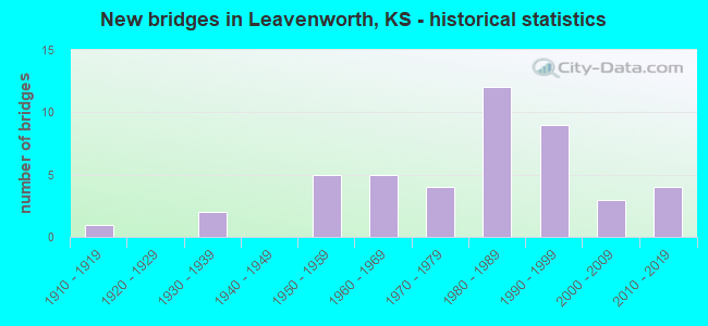
- New bridges - historical statistics
- 11910-1919
- 21930-1939
- 51950-1959
- 51960-1969
- 41970-1979
- 121980-1989
- 91990-1999
- 32000-2009
- 42010-2019

- Reconstructed bridges - Historical Statistics
- 11960-1969
- 01970-1979
- 11980-1989
- 11990-1999
- 12000-2009


- Bridge Condition - Deck
- 7.1%Very good
- 64.3%Good
- 28.6%Satisfactory

- Bridge Condition - Superstructure
- 10.7%Very good
- 57.1%Good
- 28.6%Satisfactory
- 3.6%Fair

- Bridge Condition - Substructure
- 17.9%Very good
- 60.7%Good
- 14.3%Satisfactory
- 7.1%Fair

- Bridge Condition - Channel
- 2.3%Very good
- 59.1%Good
- 31.8%Satisfactory
- 6.8%Fair

- Bridge Condition - Culverts
- 47.1%Good
- 52.9%Satisfactory
Find on map >> Show street view
Structure Number: 52026, Location: 1.0S OF KICKAPOO (Lat: 39.383583, Lng: -94.964464), Route carried "on" structure: County highway 392, Year Built: 1955, Status: Posted for load, Structure Length: 4.86m (15.94ft), Average Daily Traffic: 1,185 (year 2013), Truck Traffic: 11%, Average Future Daily Traffic: 1,485 (year 2038), Design Load: H 15, Features Intersected: UNNAMED STREAM, Facility Carried by Structure: K-14 167TH STREET
Minimum Vertical Clearance: 30.47m (99.97ft), Kilometerpoint: 0.000, Lanes on structure: 2, Owner: County Highway Agency, Approaching Roadway Width: 6.4m (21.0ft), Material/Design: Concrete continuous, Design/Construction: Tee Beam, Number Of Spans In Main Unit: 3, Length of Maximum Span: 18.3m (60.0ft), Curb-To-Curb Width: 7.5m (24.6ft), Out-to-Out Width: 8.1m (26.6ft)
Condition: Deck: Satisfactory, Superstructure: Satisfactory, Substructure: Fair, Channel: Satisfactory, Operating Rating: 34.8 metric tons, Method Used To Determine Operating Rating: Load Factor (LF), Inventory Rating: 20.9 metric tons, Method Used To Determine Inventory Rating: Load Factor (LF), Structural Evaluation: Somewhat better than minimum adequacy, Deck Geometry: Meets minimum limits, Waterway Adequacy: Equal to present desirable criteria, Approach Roadway Alignment: Equal to present desirable criteria, Designated Inspection Frequency: Every 24 months, Inspection Date: March 2020, Deck Structure Type: Concrete Cast-file-Place, Wearing Surface/Protective System: Wearing Surface: Bituminous
Find on map >> Show street view
Structure Number: 52027, Location: 1.0W 0.7N OF LEAVENWORTH (Lat: 39.358150, Lng: -94.964333), Route carried "on" structure: County highway 392, Year Built: 1955, Status: Posted for load, Structure Length: 0.61m (2.00ft), Average Daily Traffic: 1,185 (year 2013), Truck Traffic: 11%, Average Future Daily Traffic: 1,538 (year 2038), Design Load: H 15, Features Intersected: UNNAMED STREAM, Facility Carried by Structure: K-18 167TH STREET
Minimum Vertical Clearance: 30.47m (99.97ft), Kilometerpoint: 0.000, Lanes on structure: 2, Owner: County Highway Agency, Approaching Roadway Width: 7.9m (25.9ft), Material/Design: Concrete, Design/Construction: Culvert, Number Of Spans In Main Unit: 1, Length of Maximum Span: 6.1m (20.0ft), Curb-To-Curb Width: 7.6m (24.9ft), Out-to-Out Width: 8.2m (26.9ft)
Condition: Channel: Satisfactory, Culverts: Satisfactory, Operating Rating: 45.9 metric tons, Method Used To Determine Operating Rating: Load Factor (LF), Inventory Rating: 24.3 metric tons, Method Used To Determine Inventory Rating: Load Factor (LF), Structural Evaluation: Equal to present minimum criteria, Deck Geometry: Meets minimum limits, Waterway Adequacy: Equal to present minimum criteria, Approach Roadway Alignment: Equal to present desirable criteria, Bridge Posting: Required (Relationship of Operating Rating to Maximum Legal Load: 20.0 - 29.9% below), Designated Inspection Frequency: Every 24 months, Inspection Date: March 2020
Find on map >> Show street view
Structure Number: 52048, Location: 2.5S 3.5E OF LOWEMONT (Lat: 39.339522, Lng: -94.992500), Route carried "on" structure: County highway 1924, Year Built: 1986, Status: Open, Structure Length: 4.05m (13.29ft), Average Daily Traffic: 581 (year 2006), Truck Traffic: 11%, Average Future Daily Traffic: 610 (year 2038), Design Load: H 20, Features Intersected: SALT CREEK, Facility Carried by Structure: K-26 179TH STREET
Minimum Vertical Clearance: 30.47m (99.97ft), Kilometerpoint: 0.000, Lanes on structure: 2, Owner: County Highway Agency, Approaching Roadway Width: 8.5m (27.9ft), Skew: 3 degrees, Material/Design: Concrete continuous, Design/Construction: Slab, Number Of Spans In Main Unit: 3, Length of Maximum Span: 15.8m (51.8ft), Curb-To-Curb Width: 8.5m (27.9ft), Out-to-Out Width: 9.1m (29.9ft)
Condition: Deck: Satisfactory, Superstructure: Satisfactory, Substructure: Good, Channel: Satisfactory, Operating Rating: 50.4 metric tons, Method Used To Determine Operating Rating: Load Factor (LF), Inventory Rating: 27.9 metric tons, Method Used To Determine Inventory Rating: Load Factor (LF), Structural Evaluation: Equal to present minimum criteria, Deck Geometry: Somewhat better than minimum adequacy, Waterway Adequacy: Equal to present desirable criteria, Approach Roadway Alignment: Equal to present desirable criteria, Designated Inspection Frequency: Every 24 months, Inspection Date: March 2020, Deck Structure Type: Concrete Cast-file-Place, Wearing Surface/Protective System: Wearing Surface: Monolithic Concrete
Find on map >> Show street view
Structure Number: 52049, Location: 6.4E OF EASTON (Lat: 39.347100, Lng: -94.992453), Route carried "on" structure: County highway 1924, Year Built: 1972, Year Reconstructed: 1987, Status: Posted for load, Structure Length: 1.55m (5.09ft), Average Daily Traffic: 629 (year 2006), Truck Traffic: 11%, Average Future Daily Traffic: 660 (year 2038), Design Load: H 15, Features Intersected: SALT CREEK, Facility Carried by Structure: K-19 179TH STREET
Minimum Vertical Clearance: 30.47m (99.97ft), Kilometerpoint: 0.000, Lanes on structure: 2, Owner: County Highway Agency, Approaching Roadway Width: 9.1m (29.9ft), Material/Design: Steel, Design/Construction: Stringer/Multi-beam, Number Of Spans In Main Unit: 1, Length of Maximum Span: 14.9m (48.9ft), Curb-To-Curb Width: 9.8m (32.2ft), Out-to-Out Width: 10.6m (34.8ft)
Condition: Deck: Satisfactory, Superstructure: Satisfactory, Substructure: Satisfactory, Channel: Good, Operating Rating: 27.4 metric tons, Method Used To Determine Operating Rating: Load Factor (LF), Inventory Rating: 16.4 metric tons, Method Used To Determine Inventory Rating: Load Factor (LF), Structural Evaluation: Meets minimum limits, Deck Geometry: Equal to present minimum criteria, Waterway Adequacy: Somewhat better than minimum adequacy, Approach Roadway Alignment: Equal to present desirable criteria, Designated Inspection Frequency: Every 24 months, Inspection Date: March 2020, Deck Structure Type: Concrete Cast-file-Place, Wearing Surface/Protective System: Wearing Surface: Bituminous
Find on map >> Show street view
Structure Number: 52053, Location: Cnty Hwy 14 & Cnty Hwy 18 (Lat: 39.354797, Lng: -94.964006), Route carried "on" structure: County highway 14, Year Built: 1993, Status: Open, Structure Length: 3.75m (12.30ft), Average Daily Traffic: 3,030 (year 2013), Truck Traffic: 11%, Average Future Daily Traffic: 3,150 (year 2030), Design Load: HS 20, Features Intersected: Salt Creek, Facility Carried by Structure: K-9 Sante Fe Trail
Minimum Vertical Clearance: 30.47m (99.97ft), Kilometerpoint: 0.000, Lanes on structure: 2, Owner: County Highway Agency, Approaching Roadway Width: 7.9m (25.9ft), Skew: 1 degrees, Material/Design: Concrete continuous, Design/Construction: Slab, Number Of Spans In Main Unit: 3, Length of Maximum Span: 14.6m (47.9ft), Curb-To-Curb Width: 9.8m (32.2ft), Out-to-Out Width: 10.4m (34.1ft)
Condition: Deck: Good, Superstructure: Good, Substructure: Good, Channel: Good, Operating Rating: 74.9 metric tons, Method Used To Determine Operating Rating: Load Factor (LF), Inventory Rating: 44.9 metric tons, Method Used To Determine Inventory Rating: Load Factor (LF), Structural Evaluation: Better than present minimum criteria, Deck Geometry: Meets minimum limits, Waterway Adequacy: Equal to present desirable criteria, Approach Roadway Alignment: Better than present minimum criteria, Designated Inspection Frequency: Every 24 months, Inspection Date: March 2020, Deck Structure Type: Concrete Cast-file-Place, Wearing Surface/Protective System: Wearing Surface: Integral Concrete, Deck Protection: Epoxy Coated Reinforcing
Find on map >> Show street view
Structure Number: 52106900392, Location: 5.0E 1.0S OF EASTON (Lat: 39.332611, Lng: -95.010589), Route carried "on" structure: County highway , Year Built: 1981, Status: Open, Structure Length: 2.50m (8.20ft), Average Daily Traffic: 10 (year 2013), Truck Traffic: 16%, Average Future Daily Traffic: 1,113 (year 2038), Design Load: H 20, Features Intersected: TRIB. TO SALT CREEK, Facility Carried by Structure: K-24 187TH STREET
Minimum Vertical Clearance: 30.47m (99.97ft), Kilometerpoint: 0.000, Lanes on structure: 2, Owner: County Highway Agency, Approaching Roadway Width: 6.0m (19.7ft), Material/Design: Concrete continuous, Design/Construction: Slab, Number Of Spans In Main Unit: 3, Length of Maximum Span: 9.4m (30.8ft), Curb-To-Curb Width: 7.3m (24.0ft), Out-to-Out Width: 7.9m (25.9ft)
Condition: Deck: Good, Superstructure: Good, Substructure: Good, Channel: Satisfactory, Operating Rating: 50.4 metric tons, Method Used To Determine Operating Rating: Load Factor (LF), Inventory Rating: 29.7 metric tons, Method Used To Determine Inventory Rating: Load Factor (LF), Structural Evaluation: Better than present minimum criteria, Deck Geometry: Equal to present minimum criteria, Waterway Adequacy: Equal to present desirable criteria, Approach Roadway Alignment: Equal to present desirable criteria, Designated Inspection Frequency: Every 24 months, Inspection Date: March 2020, Deck Structure Type: Concrete Cast-file-Place
Find on map >> Show street view
Structure Number: 521069003928, Location: 5.0E 2.0S OF EASTON (Lat: 39.318906, Lng: -95.011672), Route carried "on" structure: County highway , Year Built: 1983, Status: Open, Structure Length: 1.01m (3.31ft), Average Daily Traffic: 26 (year 2013), Truck Traffic: 10%, Average Future Daily Traffic: 47 (year 2038), Design Load: H 20, Features Intersected: STREAM, Facility Carried by Structure: K-10 187TH STREET
Minimum Vertical Clearance: 30.47m (99.97ft), Kilometerpoint: 0.000, Lanes on structure: 2, Owner: County Highway Agency, Approaching Roadway Width: 6.0m (19.7ft), Material/Design: Steel, Design/Construction: Stringer/Multi-beam, Number Of Spans In Main Unit: 1, Length of Maximum Span: 9.5m (31.2ft), Curb-To-Curb Width: 7.2m (23.6ft), Out-to-Out Width: 7.3m (24.0ft)
Condition: Deck: Good, Superstructure: Good, Substructure: Good, Channel: Good, Operating Rating: 40.5 metric tons, Method Used To Determine Operating Rating: Allowable Stress (AS), Inventory Rating: 29.7 metric tons, Method Used To Determine Inventory Rating: Allowable Stress (AS), Structural Evaluation: Better than present minimum criteria, Deck Geometry: Somewhat better than minimum adequacy, Waterway Adequacy: Equal to present minimum criteria, Approach Roadway Alignment: Equal to present desirable criteria, Designated Inspection Frequency: Every 24 months, Inspection Date: March 2020, Deck Structure Type: Concrete Cast-file-Place
Find on map >> Show street view
Structure Number: 521071003825, Location: 1.0W OF KICKAPOO (Lat: 39.397075, Lng: -94.992625), Route carried "on" structure: County highway , Year Built: 1932, Year Reconstructed: 1960, Status: Posted for load, Structure Length: 1.74m (5.71ft), Average Daily Traffic: 12 (year 2013), Truck Traffic: 16%, Average Future Daily Traffic: 98 (year 2038), Features Intersected: PLUM CREEK, Facility Carried by Structure: K-3 KNAPP ROAD
Minimum Vertical Clearance: 30.47m (99.97ft), Kilometerpoint: 0.000, Lanes on structure: 2, Owner: County Highway Agency, Approaching Roadway Width: 5.7m (18.7ft), Material/Design: Steel, Design/Construction: Stringer/Multi-beam, Number Of Spans In Main Unit: 2, Length of Maximum Span: 11.8m (38.7ft), Curb-To-Curb Width: 5.0m (16.4ft), Out-to-Out Width: 5.0m (16.4ft)
Condition: Deck: Good, Superstructure: Good, Substructure: Satisfactory, Channel: Satisfactory, Operating Rating: 26.2 metric tons, Method Used To Determine Operating Rating: Load Factor (LF), Inventory Rating: 15.7 metric tons, Method Used To Determine Inventory Rating: Load Factor (LF), Structural Evaluation: Meets minimum limits, Deck Geometry: High priority of corrective action, Waterway Adequacy: Equal to present minimum criteria, Approach Roadway Alignment: Equal to present desirable criteria, Designated Inspection Frequency: Every 24 months, Inspection Date: March 2020, Deck Structure Type: Concrete Cast-file-Place
Find on map >> Show street view
Structure Number: 52107130394, Location: 1.8W NW COR. LEAVENWORTH (Lat: 39.318358, Lng: -94.987192), Route carried "on" structure: County highway 5216, Year Built: 1985, Status: Open, Structure Length: 2.90m (9.51ft), Average Daily Traffic: 50 (year 2013), Truck Traffic: 10%, Average Future Daily Traffic: 97 (year 2038), Design Load: HS 20, Features Intersected: TRIB. TO SALT CREEK, Facility Carried by Structure: K-30 Shawnee Rd.
Minimum Vertical Clearance: 30.47m (99.97ft), Kilometerpoint: 0.000, Lanes on structure: 2, Owner: County Highway Agency, Approaching Roadway Width: 6.0m (19.7ft), Skew: 3 degrees, Material/Design: Concrete continuous, Design/Construction: Slab, Number Of Spans In Main Unit: 3, Length of Maximum Span: 11.0m (36.1ft), Curb-To-Curb Width: 7.3m (24.0ft), Out-to-Out Width: 7.9m (25.9ft)
Condition: Deck: Good, Superstructure: Good, Substructure: Good, Channel: Good, Operating Rating: 50.4 metric tons, Method Used To Determine Operating Rating: Load Factor (LF), Inventory Rating: 30.2 metric tons, Method Used To Determine Inventory Rating: Load Factor (LF), Structural Evaluation: Better than present minimum criteria, Deck Geometry: Equal to present minimum criteria, Waterway Adequacy: Better than present minimum criteria, Approach Roadway Alignment: Equal to present minimum criteria, Designated Inspection Frequency: Every 24 months, Inspection Date: March 2020, Deck Structure Type: Concrete Cast-file-Place
Find on map >> Show street view
Structure Number: 52107300388, Location: 2.5S OF KICKAPOO (Lat: 39.359631, Lng: -94.973739), Route carried "on" structure: County highway , Year Built: 1983, Status: Open, Structure Length: 0.93m (3.05ft), Average Daily Traffic: 46 (year 2013), Truck Traffic: 16%, Average Future Daily Traffic: 72 (year 2038), Design Load: H 20, Features Intersected: TRIB. TO SALT CREEK, Facility Carried by Structure: K-20 171ST STREET
Minimum Vertical Clearance: 30.47m (99.97ft), Kilometerpoint: 0.000, Lanes on structure: 2, Owner: County Highway Agency, Approaching Roadway Width: 6.0m (19.7ft), Material/Design: Steel, Design/Construction: Stringer/Multi-beam, Number Of Spans In Main Unit: 1, Length of Maximum Span: 8.9m (29.2ft), Curb-To-Curb Width: 7.2m (23.6ft), Out-to-Out Width: 7.3m (24.0ft)
Condition: Deck: Good, Superstructure: Satisfactory, Substructure: Good, Channel: Satisfactory, Operating Rating: 40.5 metric tons, Method Used To Determine Operating Rating: Load Factor (LF), Inventory Rating: 29.7 metric tons, Method Used To Determine Inventory Rating: Load Factor (LF), Structural Evaluation: Equal to present minimum criteria, Deck Geometry: Somewhat better than minimum adequacy, Waterway Adequacy: Equal to present minimum criteria, Approach Roadway Alignment: Equal to present desirable criteria, Designated Inspection Frequency: Every 24 months, Inspection Date: March 2020, Deck Structure Type: Concrete Cast-file-Place
Find on map >> Show street view
Structure Number: 52107520386, Location: 1.5S 1.2E OF KICKAPOO (Lat: 39.375383, Lng: -94.951186), Route carried "on" structure: County highway , Year Built: 1968, Status: Posted for load, Structure Length: 3.34m (10.96ft), Average Daily Traffic: 152 (year 2006), Truck Traffic: 16%, Average Future Daily Traffic: 160 (year 2038), Design Load: H 15, Features Intersected: SALT CREEK, Facility Carried by Structure: K-11 COFFIN ROAD
Minimum Vertical Clearance: 30.47m (99.97ft), Kilometerpoint: 0.000, Lanes on structure: 2, Owner: County Highway Agency, Approaching Roadway Width: 6.7m (22.0ft), Material/Design: Concrete continuous, Design/Construction: Tee Beam, Number Of Spans In Main Unit: 3, Length of Maximum Span: 12.5m (41.0ft), Curb-To-Curb Width: 7.5m (24.6ft), Out-to-Out Width: 8.0m (26.2ft)
Condition: Deck: Good, Superstructure: Satisfactory, Substructure: Good, Channel: Good, Operating Rating: 22.5 metric tons, Method Used To Determine Operating Rating: Load Factor (LF), Inventory Rating: 16.2 metric tons, Method Used To Determine Inventory Rating: Load Factor (LF), Structural Evaluation: Somewhat better than minimum adequacy, Deck Geometry: Somewhat better than minimum adequacy, Waterway Adequacy: Equal to present minimum criteria, Approach Roadway Alignment: Equal to present desirable criteria, Bridge Posting: Required (Relationship of Operating Rating to Maximum Legal Load: > 39.9% below), Designated Inspection Frequency: Every 24 months, Inspection Date: March 2020, Deck Structure Type: Concrete Cast-file-Place
Find on map >> Show street view
Structure Number: 541071005328, Location: 1.0N 1.0W OF GOODRICH (Lat: 39.305772, Lng: -95.010111), Route carried "on" structure: County highway , Year Built: 1975, Status: Open, Structure Length: 0.88m (2.89ft), Average Daily Traffic: 20 (year 2006), Average Future Daily Traffic: 25 (year 2037), Features Intersected: GOODRICH CREEK, Facility Carried by Structure: LOCAL RD. 13A
Minimum Vertical Clearance: 30.47m (99.97ft), Kilometerpoint: 0.000, Lanes on structure: 2, Owner: County Highway Agency, Approaching Roadway Width: 6.7m (22.0ft), Material/Design: Concrete, Design/Construction: Culvert, Number Of Spans In Main Unit: 2, Length of Maximum Span: 4.3m (14.1ft), Curb-To-Curb Width: 7.3m (24.0ft), Out-to-Out Width: 7.9m (25.9ft)
Condition: Channel: Satisfactory, Culverts: Good, Operating Rating: 25.2 metric tons, Method Used To Determine Operating Rating: Load Factor (LF), Inventory Rating: 18.1 metric tons, Method Used To Determine Inventory Rating: Load Factor (LF), Structural Evaluation: Somewhat better than minimum adequacy, Deck Geometry: Equal to present minimum criteria, Waterway Adequacy: Better than present minimum criteria, Approach Roadway Alignment: Equal to present minimum criteria, Designated Inspection Frequency: Every 24 months, Inspection Date: January 2022
Find on map >> Show street view
Structure Number: 415400523501925, Location: 20TH S OF DAKOTA (Lat: 39.324564, Lng: -94.950606), Route carried "on" structure: City street 3501, Year Built: 1968, Status: Open, Structure Length: 3.11m (10.20ft), Average Daily Traffic: 5,475 (year 2007), Truck Traffic: 6%, Average Future Daily Traffic: 7,570 (year 2043), Design Load: H 20, Features Intersected: THREE MILE CREEK, Facility Carried by Structure: 20TH ST A.52-1.24
Minimum Vertical Clearance: 30.47m (99.97ft), Kilometerpoint: 0.000, Lanes on structure: 2, Owner: City or Municipal Highway Agency, Approaching Roadway Width: 9.8m (32.2ft), Skew: 3 degrees, Material/Design: Concrete continuous, Design/Construction: Slab, Number Of Spans In Main Unit: 3, Length of Maximum Span: 10.7m (35.1ft), Curb or Sidewalk Widths: Left: 1.4m (4.6ft), Right: 1.4m (4.6ft), Curb-To-Curb Width: 9.8m (32.2ft), Out-to-Out Width: 13.2m (43.3ft)
Condition: Deck: Satisfactory, Superstructure: Satisfactory, Substructure: Satisfactory, Channel: Fair, Operating Rating: 49.0 metric tons, Method Used To Determine Operating Rating: Load Factor (LF), Inventory Rating: 29.4 metric tons, Method Used To Determine Inventory Rating: Load Factor (LF), Structural Evaluation: Equal to present minimum criteria, Deck Geometry: Meets minimum limits, Waterway Adequacy: Equal to present minimum criteria, Approach Roadway Alignment: Equal to present desirable criteria, Designated Inspection Frequency: Every 24 months, Inspection Date: July 2021, Deck Structure Type: Concrete Cast-file-Place
Find on map >> Show street view
Structure Number: 415400523507985, Location: 0.6 S OF LIMIT ST (Lat: 39.280800, Lng: -94.937797), Route carried "on" structure: City street 3507, Year Built: 1960, Status: Open, Structure Length: 0.91m (2.99ft), Average Daily Traffic: 400 (year 2007), Truck Traffic: 6%, Average Future Daily Traffic: 440 (year 2043), Features Intersected: FIVE MILE CREEK, Facility Carried by Structure: N LAW RD D.54-1.98
Minimum Vertical Clearance: 30.47m (99.97ft), Kilometerpoint: 0.000, Lanes on structure: 2, Owner: City or Municipal Highway Agency, Approaching Roadway Width: 7.0m (23.0ft), Material/Design: Steel, Design/Construction: Culvert, Number Of Spans In Main Unit: 1, Length of Maximum Span: 9.1m (29.9ft), Curb or Sidewalk Widths: Left: 1.5m (4.9ft), Right: 0.0m
Condition: Channel: Satisfactory, Culverts: Satisfactory, Operating Rating: 19.9 metric tons, Method Used To Determine Operating Rating: Load Factor (LF), Inventory Rating: 11.7 metric tons, Method Used To Determine Inventory Rating: Load Factor (LF), Structural Evaluation: Meets minimum limits, Waterway Adequacy: Equal to present minimum criteria, Approach Roadway Alignment: Equal to present minimum criteria, Bridge Posting: Required (Relationship of Operating Rating to Maximum Legal Load: > 39.9% below), Length Of Structure Improvement: 6.10m (20.01ft), Designated Inspection Frequency: Every 24 months, Inspection Date: July 2021, Bridge Improvement Cost: $5,000, Roadway Improvement Cost: $100,000, Total Project Cost: $150,000
Find on map >> Show street view
Structure Number: 415400523509927, Location: 13TH ST. S OF OTTAWA (Lat: 39.321586, Lng: -94.934872), Route carried "on" structure: City street 3509, Year Built: 1970, Status: Open, Structure Length: 0.94m (3.08ft), Average Daily Traffic: 1,090 (year 2007), Truck Traffic: 2%, Average Future Daily Traffic: 1,200 (year 2043), Design Load: H 20, Features Intersected: THREE MILE CREEK, Facility Carried by Structure: 13TH ST A.70-2.09
Minimum Vertical Clearance: 7.62m (25.00ft), Kilometerpoint: 0.000, Lanes on structure: 2, Owner: City or Municipal Highway Agency, Approaching Roadway Width: 11.1m (36.4ft), Material/Design: Concrete, Design/Construction: Culvert, Number Of Spans In Main Unit: 2, Length of Maximum Span: 4.3m (14.1ft), Curb or Sidewalk Widths: Left: 1.4m (4.6ft), Right: 0.4m (1.3ft), Curb-To-Curb Width: 11.1m (36.4ft), Out-to-Out Width: 13.6m (44.6ft)
Condition: Channel: Good, Culverts: Satisfactory, Operating Rating: 60.0 metric tons, Method Used To Determine Operating Rating: Load Factor (LF), Inventory Rating: 35.9 metric tons, Method Used To Determine Inventory Rating: Load Factor (LF), Structural Evaluation: Equal to present minimum criteria, Deck Geometry: Equal to present minimum criteria, Waterway Adequacy: Better than present minimum criteria, Approach Roadway Alignment: Equal to present desirable criteria, Designated Inspection Frequency: Every 24 months, Inspection Date: July 2021
Find on map >> Show street view
Structure Number: 415400523510987, Location: N. OF W LEAVENWORTH TFWY (Lat: 39.282958, Lng: -94.947653), Route carried "on" structure: City street 3510, Year Built: 1997, Status: Open, Structure Length: 0.76m (2.49ft), Average Daily Traffic: 1,285 (year 2007), Truck Traffic: 2%, Average Future Daily Traffic: 1,415 (year 2043), Design Load: HS 20, Features Intersected: FIVE MILE CREEK, Facility Carried by Structure: CO HWY 5 D.39-1.45
Minimum Vertical Clearance: 30.47m (99.97ft), Kilometerpoint: 0.000, Lanes on structure: 3, Owner: City or Municipal Highway Agency, Approaching Roadway Width: 8.1m (26.6ft), Material/Design: Concrete, Design/Construction: Culvert, Number Of Spans In Main Unit: 2, Length of Maximum Span: 3.7m (12.1ft), Curb or Sidewalk Widths: Left: 0.0m, Right: 1.8m (5.9ft)
Condition: Channel: Good, Culverts: Good, Operating Rating: 54.4 metric tons, Method Used To Determine Operating Rating: Field evaluation and documented engineering judgment, Inventory Rating: 32.7 metric tons, Method Used To Determine Inventory Rating: Field evaluation and documented engineering judgment, Structural Evaluation: Better than present minimum criteria, Waterway Adequacy: Better than present minimum criteria, Approach Roadway Alignment: Equal to present desirable criteria, Designated Inspection Frequency: Every 24 months, Inspection Date: July 2021
Find on map >> Show street view
Structure Number: 41540052351099, Location: Limit St west of 16th St (Lat: 39.288553, Lng: -94.941847), Route carried "on" structure: City street 3510, Year Built: 2014, Status: Open, Structure Length: 0.62m (2.03ft), Average Daily Traffic: 3,500 (year 2012), Truck Traffic: 5%, Average Future Daily Traffic: 3,900 (year 2043), Design Load: HL 93, Features Intersected: 5 MILE CREEK TRIB, Facility Carried by Structure: LIMIT ST.
Minimum Vertical Clearance: 30.47m (99.97ft), Kilometerpoint: 0.000, Lanes on structure: 2, Owner: City or Municipal Highway Agency, Approaching Roadway Width: 8.1m (26.6ft), Skew: 1 degrees, Material/Design: Concrete, Design/Construction: Culvert, Number Of Spans In Main Unit: 1, Length of Maximum Span: 6.2m (20.3ft), Curb or Sidewalk Widths: Left: 1.5m (4.9ft), Right: 2.4m (7.9ft)
Condition: Channel: Good, Culverts: Good, Operating Rating: 78.6 metric tons, Method Used To Determine Operating Rating: Load Factor (LF), Inventory Rating: 47.1 metric tons, Method Used To Determine Inventory Rating: Load Factor (LF), Structural Evaluation: Better than present minimum criteria, Waterway Adequacy: Equal to present desirable criteria, Approach Roadway Alignment: Equal to present desirable criteria, Designated Inspection Frequency: Every 24 months, Inspection Date: July 2021
Find on map >> Show street view
Structure Number: 415400523513851, Location: TENTH AVE. S OF GATEWOOD (Lat: 39.280636, Lng: -94.927869), Route carried "on" structure: City street 3513, Year Built: 1980, Status: Open, Structure Length: 1.07m (3.51ft), Average Daily Traffic: 7,105 (year 2007), Truck Traffic: 6%, Average Future Daily Traffic: 7,815 (year 2043), Features Intersected: FIVE MILE CREEK, Facility Carried by Structure: 10TH AVE D.51-2.50
Minimum Vertical Clearance: 7.62m (25.00ft), Kilometerpoint: 0.000, Lanes on structure: 4, Owner: City or Municipal Highway Agency, Approaching Roadway Width: 15.2m (49.9ft), Material/Design: Concrete, Design/Construction: Culvert, Number Of Spans In Main Unit: 2, Length of Maximum Span: 4.9m (16.1ft), Curb or Sidewalk Widths: Left: 1.2m (3.9ft), Right: 1.2m (3.9ft)
Condition: Channel: Satisfactory, Culverts: Satisfactory, Operating Rating: 32.7 metric tons, Method Used To Determine Operating Rating: Field evaluation and documented engineering judgment, Inventory Rating: 32.7 metric tons, Method Used To Determine Inventory Rating: Field evaluation and documented engineering judgment, Structural Evaluation: Equal to present minimum criteria, Waterway Adequacy: Equal to present minimum criteria, Approach Roadway Alignment: Equal to present desirable criteria, Designated Inspection Frequency: Every 24 months, Inspection Date: July 2021
Find on map >> Show street view
Structure Number: 415400523514966, Location: MARION W OF 2ND STREET (Lat: 39.295122, Lng: -94.906172), Route carried "on" structure: City street 3514, Year Built: 1971, Status: Open, Structure Length: 1.65m (5.41ft), Average Daily Traffic: 2,200 (year 2007), Truck Traffic: 1%, Average Future Daily Traffic: 2,420 (year 2043), Features Intersected: FIVE MILE CREEK, Facility Carried by Structure: MARION C.56-3.67
Minimum Vertical Clearance: 30.47m (99.97ft), Kilometerpoint: 0.000, Lanes on structure: 2, Owner: City or Municipal Highway Agency, Approaching Roadway Width: 13.1m (43.0ft), Skew: 2 degrees, Material/Design: Concrete, Design/Construction: Culvert, Number Of Spans In Main Unit: 3, Length of Maximum Span: 4.9m (16.1ft), Curb or Sidewalk Widths: Left: 0.9m (3.0ft), Right: 0.0m
Condition: Channel: Fair, Culverts: Satisfactory, Operating Rating: 74.6 metric tons, Method Used To Determine Operating Rating: Load Factor (LF), Inventory Rating: 44.6 metric tons, Method Used To Determine Inventory Rating: Load Factor (LF), Structural Evaluation: Equal to present minimum criteria, Waterway Adequacy: Better than present minimum criteria, Approach Roadway Alignment: Equal to present desirable criteria, Designated Inspection Frequency: Every 24 months, Inspection Date: July 2021
Find on map >> Show street view
Structure Number: 415400523515002, Location: 10TH ST S OF MIAMI (Lat: 39.318689, Lng: -94.928267), Route carried "on" structure: City street 3515, Year Built: 1983, Status: Open, Structure Length: 3.44m (11.29ft), Average Daily Traffic: 7,170 (year 2007), Truck Traffic: 6%, Average Future Daily Traffic: 7,900 (year 2043), Design Load: HS 20, Features Intersected: THREE MILE CREEK
Minimum Vertical Clearance: 7.62m (25.00ft), Kilometerpoint: 0.000, Lanes on structure: 2, Owner: City or Municipal Highway Agency, Approaching Roadway Width: 10.0m (32.8ft), Material/Design: Concrete continuous, Design/Construction: Slab, Number Of Spans In Main Unit: 3, Length of Maximum Span: 13.4m (44.0ft), Curb or Sidewalk Widths: Left: 1.5m (4.9ft), Right: 0.0m, Curb-To-Curb Width: 10.1m (33.1ft), Out-to-Out Width: 12.6m (41.3ft)
Condition: Deck: Good, Superstructure: Good, Substructure: Good, Channel: Good, Operating Rating: 54.0 metric tons, Method Used To Determine Operating Rating: Load Factor (LF), Inventory Rating: 32.3 metric tons, Method Used To Determine Inventory Rating: Load Factor (LF), Structural Evaluation: Better than present minimum criteria, Deck Geometry: Meets minimum limits, Waterway Adequacy: Equal to present desirable criteria, Approach Roadway Alignment: Equal to present desirable criteria, Designated Inspection Frequency: Every 24 months, Inspection Date: July 2021, Deck Structure Type: Concrete Cast-file-Place
Find on map >> Show street view
Structure Number: 415400523519025, Location: BROADWAY S. OF CHEROKEE (Lat: 39.315808, Lng: -94.920872), Route carried "on" structure: City street 3519, Year Built: 1991, Status: Open, Structure Length: 4.97m (16.31ft), Average Daily Traffic: 4,435 (year 2007), Truck Traffic: 6%, Average Future Daily Traffic: 4,878 (year 2043), Design Load: HS 20, Features Intersected: THREE MILE CREEK, Facility Carried by Structure: BROADWAY B.13-2.85
Minimum Vertical Clearance: 5.48m (17.98ft), Kilometerpoint: 0.000, Lanes on structure: 2, Owner: City or Municipal Highway Agency, Approaching Roadway Width: 12.1m (39.7ft), Skew: 3 degrees, Material/Design: Concrete continuous, Design/Construction: Slab, Number Of Spans In Main Unit: 3, Length of Maximum Span: 19.5m (64.0ft), Curb or Sidewalk Widths: Left: 1.5m (4.9ft), Right: 1.5m (4.9ft), Curb-To-Curb Width: 12.3m (40.4ft), Out-to-Out Width: 17.0m (55.8ft)
Condition: Deck: Satisfactory, Superstructure: Satisfactory, Substructure: Good, Channel: Good, Operating Rating: 76.3 metric tons, Method Used To Determine Operating Rating: Load Factor (LF), Inventory Rating: 45.6 metric tons, Method Used To Determine Inventory Rating: Load Factor (LF), Structural Evaluation: Equal to present minimum criteria, Deck Geometry: Equal to present minimum criteria, Waterway Adequacy: Better than present minimum criteria, Approach Roadway Alignment: Equal to present desirable criteria, Designated Inspection Frequency: Every 24 months, Inspection Date: August 2021, Deck Structure Type: Concrete Cast-file-Place
Find on map >> Show street view
Structure Number: 415400523521006, Location: SHRINE PK RD S OF LIMIT (Lat: 39.284094, Lng: -94.918447), Route carried "on" structure: City street 3521, Year Built: 1993, Status: Open, Structure Length: 4.08m (13.39ft), Average Daily Traffic: 5,500 (year 2007), Truck Traffic: 5%, Average Future Daily Traffic: 6,050 (year 2043), Design Load: HS 20, Features Intersected: FIVE MILE CREEK
Minimum Vertical Clearance: 6.09m (19.98ft), Kilometerpoint: 0.000, Lanes on structure: 2, Owner: City or Municipal Highway Agency, Approaching Roadway Width: 10.3m (33.8ft), Skew: 4 degrees, Material/Design: Concrete continuous, Design/Construction: Slab, Number Of Spans In Main Unit: 3, Length of Maximum Span: 15.2m (49.9ft), Curb or Sidewalk Widths: Left: 1.5m (4.9ft), Right: 0.0m, Curb-To-Curb Width: 10.4m (34.1ft), Out-to-Out Width: 12.8m (42.0ft)
Condition: Deck: Good, Superstructure: Good, Substructure: Good, Channel: Good, Operating Rating: 30.1 metric tons, Method Used To Determine Operating Rating: Load and Resistance Factor Rating (LRFR) rating reported by rating factor(RF) method using HL-93 loadings, Inventory Rating: 23.3 metric tons, Method Used To Determine Inventory Rating: Load and Resistance Factor Rating (LRFR) rating reported by rating factor(RF) method using HL-93 loadings, Structural Evaluation: Somewhat better than minimum adequacy, Deck Geometry: Meets minimum limits, Waterway Adequacy: Equal to present desirable criteria, Approach Roadway Alignment: Equal to present desirable criteria, Designated Inspection Frequency: Every 24 months, Inspection Date: July 2021, Deck Structure Type: Concrete Cast-file-Place, Wearing Surface/Protective System: Deck Protection: Epoxy Coated Reinforcing
Find on map >> Show street view
Structure Number: 415400523523023, Location: 7TH S OF CHEROKEE ST. (Lat: 39.315728, Lng: -94.918050), Route carried "on" structure: City street 3523, Year Built: 1991, Status: Open, Structure Length: 3.44m (11.29ft), Average Daily Traffic: 5,725 (year 2007), Truck Traffic: 5%, Average Future Daily Traffic: 6,298 (year 2043), Design Load: HS 20, Features Intersected: THREE MILE CREEK
Minimum Vertical Clearance: 30.47m (99.97ft), Kilometerpoint: 0.000, Lanes on structure: 2, Owner: City or Municipal Highway Agency, Approaching Roadway Width: 12.1m (39.7ft), Material/Design: Concrete continuous, Design/Construction: Slab, Number Of Spans In Main Unit: 3, Length of Maximum Span: 12.8m (42.0ft), Curb or Sidewalk Widths: Left: 0.0m, Right: 1.7m (5.6ft), Curb-To-Curb Width: 12.2m (40.0ft), Out-to-Out Width: 14.8m (48.6ft)
Condition: Deck: Good, Superstructure: Good, Substructure: Very good, Channel: Good, Operating Rating: 59.1 metric tons, Method Used To Determine Operating Rating: Load Factor (LF), Inventory Rating: 35.4 metric tons, Method Used To Determine Inventory Rating: Load Factor (LF), Structural Evaluation: Better than present minimum criteria, Deck Geometry: Somewhat better than minimum adequacy, Waterway Adequacy: Equal to present desirable criteria, Approach Roadway Alignment: Equal to present desirable criteria, Designated Inspection Frequency: Every 24 months, Inspection Date: August 2021, Deck Structure Type: Concrete Cast-file-Place, Wearing Surface/Protective System: Deck Protection: Epoxy Coated Reinforcing
Find on map >> Show street view
Structure Number: 415400523525942, Location: 6TH N OF OAK STREET (Lat: 39.315711, Lng: -94.916464), Route carried "on" structure: City street 3525, Year Built: 2007, Status: Open, Structure Length: 3.60m (11.81ft), Average Daily Traffic: 1,035 (year 2007), Truck Traffic: 6%, Average Future Daily Traffic: 1,150 (year 2043), Design Load: HS 20, Features Intersected: THREE MILE CREEK, Facility Carried by Structure: 6TH ST B.13-3.08
Minimum Vertical Clearance: 30.47m (99.97ft), Kilometerpoint: 0.000, Lanes on structure: 2, Owner: City or Municipal Highway Agency, Approaching Roadway Width: 12.1m (39.7ft), Material/Design: Concrete continuous, Design/Construction: Slab, Number Of Spans In Main Unit: 3, Length of Maximum Span: 14.0m (45.9ft), Curb or Sidewalk Widths: Left: 2.4m (7.9ft), Right: 1.5m (4.9ft), Curb-To-Curb Width: 8.4m (27.6ft), Out-to-Out Width: 13.5m (44.3ft)
Condition: Deck: Good, Superstructure: Good, Substructure: Very good, Channel: Good, Operating Rating: 94.8 metric tons, Method Used To Determine Operating Rating: Load Factor (LF), Inventory Rating: 56.6 metric tons, Method Used To Determine Inventory Rating: Load Factor (LF), Structural Evaluation: Better than present minimum criteria, Deck Geometry: Meets minimum limits, Waterway Adequacy: Equal to present desirable criteria, Approach Roadway Alignment: Equal to present desirable criteria, Designated Inspection Frequency: Every 24 months, Inspection Date: August 2021, Deck Structure Type: Concrete Cast-file-Place
Find on map >> Show street view
Structure Number: 415400523526001, Location: CHEROKEE ST W OF BROADWAY (Lat: 39.316269, Lng: -94.921483), Route carried "on" structure: City street 3526, Year Built: 1981, Status: Open, Structure Length: 2.50m (8.20ft), Average Daily Traffic: 3,130 (year 2007), Truck Traffic: 6%, Average Future Daily Traffic: 3,450 (year 2043), Design Load: HS 20, Features Intersected: THREE MILE CREEK, Facility Carried by Structure: CHEROKEE B.09-2.80
Minimum Vertical Clearance: 6.40m (21.00ft), Kilometerpoint: 0.000, Lanes on structure: 2, Owner: City or Municipal Highway Agency, Approaching Roadway Width: 12.1m (39.7ft), Skew: 1 degrees, Material/Design: Concrete continuous, Design/Construction: Slab, Number Of Spans In Main Unit: 3, Length of Maximum Span: 9.4m (30.8ft), Curb or Sidewalk Widths: Left: 1.5m (4.9ft), Right: 1.5m (4.9ft), Curb-To-Curb Width: 12.3m (40.4ft), Out-to-Out Width: 16.9m (55.4ft)
Condition: Deck: Good, Superstructure: Good, Substructure: Good, Channel: Good, Operating Rating: 58.0 metric tons, Method Used To Determine Operating Rating: Load Factor (LF), Inventory Rating: 34.7 metric tons, Method Used To Determine Inventory Rating: Load Factor (LF), Structural Evaluation: Better than present minimum criteria, Deck Geometry: Equal to present minimum criteria, Waterway Adequacy: Equal to present minimum criteria, Approach Roadway Alignment: Equal to present desirable criteria, Designated Inspection Frequency: Every 24 months, Inspection Date: August 2021, Deck Structure Type: Concrete Cast-file-Place
Find on map >> Show street view
Structure Number: 415400523527942, Location: 5TH N OF OAK STREET (Lat: 39.315200, Lng: -94.914742), Route carried "on" structure: City street 3527, Year Built: 1967, Status: Open, Structure Length: 1.86m (6.10ft), Average Daily Traffic: 3,520 (year 2007), Truck Traffic: 6%, Average Future Daily Traffic: 3,872 (year 2043), Design Load: HS 20, Features Intersected: THREE MILE CREEK, Facility Carried by Structure: 5TH ST B.18-3.17
Minimum Vertical Clearance: 7.62m (25.00ft), Kilometerpoint: 0.000, Lanes on structure: 2, Owner: City or Municipal Highway Agency, Approaching Roadway Width: 12.1m (39.7ft), Material/Design: Prestressed concrete, Design/Construction: Tee Beam, Number Of Spans In Main Unit: 1, Length of Maximum Span: 18.0m (59.1ft), Curb or Sidewalk Widths: Left: 1.3m (4.3ft), Right: 1.3m (4.3ft), Curb-To-Curb Width: 10.8m (35.4ft), Out-to-Out Width: 14.6m (47.9ft)
Condition: Deck: Satisfactory, Superstructure: Good, Substructure: Fair, Channel: Satisfactory, Operating Rating: 32.7 metric tons, Method Used To Determine Operating Rating: Field evaluation and documented engineering judgment, Inventory Rating: 32.7 metric tons, Method Used To Determine Inventory Rating: Field evaluation and documented engineering judgment, Structural Evaluation: Somewhat better than minimum adequacy, Deck Geometry: Somewhat better than minimum adequacy, Waterway Adequacy: Equal to present minimum criteria, Approach Roadway Alignment: Equal to present desirable criteria, Length Of Structure Improvement: 2.59m (8.50ft), Designated Inspection Frequency: Every 24 months, Inspection Date: August 2021, Bridge Improvement Cost: $448,000, Roadway Improvement Cost: $65,000, Total Project Cost: $751,000, Deck Structure Type: Concrete Cast-file-Place, Wearing Surface/Protective System: Wearing Surface: Bituminous
Find on map >> Show street view
Structure Number: 41540052352797, Location: Limit Street at 2nd Ave (Lat: 39.289094, Lng: -94.912961), Route carried "on" structure: City street 3527, Year Built: 2014, Status: Open, Structure Length: 3.73m (12.24ft), Average Daily Traffic: 8,600 (year 2012), Truck Traffic: 10%, Average Future Daily Traffic: 9,500 (year 2043), Design Load: HL 93, Features Intersected: FIVE MILE CREEK, Facility Carried by Structure: LIMIT ST C.97-3.30
Minimum Vertical Clearance: 30.47m (99.97ft), Kilometerpoint: 0.000, Lanes on structure: 3, Owner: City or Municipal Highway Agency, Approaching Roadway Width: 13.3m (43.6ft), Skew: 1 degrees, Material/Design: Concrete continuous, Design/Construction: Slab, Number Of Spans In Main Unit: 3, Length of Maximum Span: 14.6m (47.9ft), Curb or Sidewalk Widths: Left: 2.4m (7.9ft), Right: 1.8m (5.9ft), Curb-To-Curb Width: 13.4m (44.0ft), Out-to-Out Width: 18.7m (61.4ft)
Condition: Deck: Very good, Superstructure: Very good, Substructure: Good, Channel: Good, Operating Rating: 68.4 metric tons, Method Used To Determine Operating Rating: Load and Resistance Factor Rating (LRFR) rating reported by rating factor(RF) method using HL-93 loadings, Inventory Rating: 52.8 metric tons, Method Used To Determine Inventory Rating: Load and Resistance Factor Rating (LRFR) rating reported by rating factor(RF) method using HL-93 loadings, Structural Evaluation: Better than present minimum criteria, Deck Geometry: Somewhat better than minimum adequacy, Waterway Adequacy: Equal to present desirable criteria, Approach Roadway Alignment: Equal to present desirable criteria, Designated Inspection Frequency: Every 24 months, Inspection Date: July 2021, Deck Structure Type: Concrete Cast-file-Place
Find on map >> Show street view
Structure Number: 415400523530007, Location: SHAWNEE E OF 11TH (Lat: 39.317814, Lng: -94.929817), Route carried "on" structure: City street 3530, Year Built: 1984, Status: Open, Structure Length: 0.79m (2.59ft), Average Daily Traffic: 2,450 (year 2007), Truck Traffic: 4%, Average Future Daily Traffic: 2,800 (year 2043), Design Load: H 20, Features Intersected: SOUTH BRANCH 3 MILE CK.
Minimum Vertical Clearance: 30.47m (99.97ft), Kilometerpoint: 0.000, Lanes on structure: 2, Owner: City or Municipal Highway Agency, Approaching Roadway Width: 9.7m (31.8ft), Material/Design: Concrete, Design/Construction: Culvert, Number Of Spans In Main Unit: 1, Length of Maximum Span: 7.3m (24.0ft), Curb or Sidewalk Widths: Left: 1.8m (5.9ft), Right: 1.8m (5.9ft)
Condition: Channel: Good, Culverts: Good, Operating Rating: 54.4 metric tons, Method Used To Determine Operating Rating: Field evaluation and documented engineering judgment, Inventory Rating: 32.7 metric tons, Method Used To Determine Inventory Rating: Field evaluation and documented engineering judgment, Structural Evaluation: Better than present minimum criteria, Waterway Adequacy: Better than present minimum criteria, Approach Roadway Alignment: Equal to present desirable criteria, Designated Inspection Frequency: Every 24 months, Inspection Date: July 2021
Find on map >> Show street view
Structure Number: 415400523530008, Location: 8TH AND SHAWNEE (Lat: 39.317814, Lng: -94.923847), Route carried "on" structure: City street 3530, Year Built: 2007, Status: Open, Structure Length: 3.10m (10.17ft), Average Daily Traffic: 2,325 (year 2007), Truck Traffic: 6%, Average Future Daily Traffic: 2,650 (year 2043), Design Load: HS 20, Features Intersected: THREE MILE CREEK
Minimum Vertical Clearance: 6.09m (19.98ft), Kilometerpoint: 0.000, Lanes on structure: 2, Owner: City or Municipal Highway Agency, Approaching Roadway Width: 11.1m (36.4ft), Material/Design: Concrete continuous, Design/Construction: Slab, Number Of Spans In Main Unit: 3, Length of Maximum Span: 12.2m (40.0ft), Curb or Sidewalk Widths: Left: 1.8m (5.9ft), Right: 1.8m (5.9ft), Curb-To-Curb Width: 11.1m (36.4ft), Out-to-Out Width: 15.9m (52.2ft)
Condition: Deck: Good, Superstructure: Good, Substructure: Good, Channel: Satisfactory, Operating Rating: 74.9 metric tons, Method Used To Determine Operating Rating: Load Factor (LF), Inventory Rating: 44.9 metric tons, Method Used To Determine Inventory Rating: Load Factor (LF), Structural Evaluation: Better than present minimum criteria, Deck Geometry: Somewhat better than minimum adequacy, Waterway Adequacy: Equal to present minimum criteria, Approach Roadway Alignment: Equal to present desirable criteria, Designated Inspection Frequency: Every 24 months, Inspection Date: July 2021, Deck Structure Type: Concrete Cast-file-Place
Find on map >> Show street view
Structure Number: 415400523531005, Location: THIRD ST. N OF WALNUT (Lat: 39.315453, Lng: -94.911603), Route carried "on" structure: City street 3531, Year Built: 1988, Status: Open, Structure Length: 4.05m (13.29ft), Average Daily Traffic: 2,795 (year 2007), Truck Traffic: 6%, Average Future Daily Traffic: 3,075 (year 2043), Design Load: HS 20, Features Intersected: THREE MILE CREEK
Minimum Vertical Clearance: 6.70m (21.98ft), Kilometerpoint: 0.000, Lanes on structure: 2, Owner: City or Municipal Highway Agency, Approaching Roadway Width: 11.6m (38.1ft), Material/Design: Prestressed concrete continuous, Design/Construction: Stringer/Multi-beam, Number Of Spans In Main Unit: 3, Length of Maximum Span: 15.2m (49.9ft), Curb or Sidewalk Widths: Left: 1.4m (4.6ft), Right: 0.0m, Curb-To-Curb Width: 12.0m (39.4ft), Out-to-Out Width: 14.2m (46.6ft)
Condition: Deck: Good, Superstructure: Good, Substructure: Good, Channel: Good, Operating Rating: 43.5 metric tons, Method Used To Determine Operating Rating: Load Factor (LF), Inventory Rating: 24.5 metric tons, Method Used To Determine Inventory Rating: Load Factor (LF), Structural Evaluation: Equal to present minimum criteria, Deck Geometry: Somewhat better than minimum adequacy, Waterway Adequacy: Better than present minimum criteria, Approach Roadway Alignment: Equal to present desirable criteria, Designated Inspection Frequency: Every 24 months, Inspection Date: August 2021, Deck Structure Type: Concrete Cast-file-Place, Wearing Surface/Protective System: Deck Protection: Epoxy Coated Reinforcing
Find on map >> Show street view
Structure Number: 415400523532927, Location: OTTAWA W OF 13TH ST. TERR (Lat: 39.322300, Lng: -94.937678), Route carried "on" structure: City street 3532, Year Built: 1956, Status: Open, Structure Length: 1.16m (3.81ft), Average Daily Traffic: 1,315 (year 2007), Truck Traffic: 6%, Average Future Daily Traffic: 1,450 (year 2043), Design Load: H 20, Features Intersected: THREE MILE CREEK, Facility Carried by Structure: OTTAW ST A.67-1.93
Minimum Vertical Clearance: 5.79m (19.00ft), Kilometerpoint: 0.000, Lanes on structure: 2, Owner: City or Municipal Highway Agency, Approaching Roadway Width: 11.2m (36.7ft), Skew: 3 degrees, Material/Design: Concrete, Design/Construction: Slab, Number Of Spans In Main Unit: 1, Length of Maximum Span: 10.4m (34.1ft), Curb or Sidewalk Widths: Left: 1.7m (5.6ft), Right: 1.7m (5.6ft), Curb-To-Curb Width: 11.2m (36.7ft), Out-to-Out Width: 15.2m (49.9ft)
Condition: Deck: Satisfactory, Superstructure: Satisfactory, Substructure: Good, Channel: Good, Operating Rating: 27.2 metric tons, Method Used To Determine Operating Rating: Load and Resistance Factor Rating (LRFR) rating reported by rating factor(RF) method using HL-93 loadings, Inventory Rating: 21.1 metric tons, Method Used To Determine Inventory Rating: Load and Resistance Factor Rating (LRFR) rating reported by rating factor(RF) method using HL-93 loadings, Structural Evaluation: Somewhat better than minimum adequacy, Deck Geometry: Equal to present minimum criteria, Waterway Adequacy: Better than present minimum criteria, Approach Roadway Alignment: Equal to present desirable criteria, Designated Inspection Frequency: Every 24 months, Inspection Date: July 2021, Deck Structure Type: Concrete Cast-file-Place, Wearing Surface/Protective System: Wearing Surface: Bituminous
Find on map >> Show street view
Structure Number: 415400523533003, Location: ON 2ND ST. NR. TREAT. PL. (Lat: 39.301006, Lng: -94.905100), Route carried "on" structure: City street 3533, Year Built: 1981, Status: Open, Structure Length: 3.44m (11.29ft), Average Daily Traffic: 2,900 (year 2007), Truck Traffic: 10%, Average Future Daily Traffic: 3,190 (year 2043), Design Load: HS 20, Features Intersected: FIVE MILE CREEK, Facility Carried by Structure: 2ND ST C.16-3.69
Minimum Vertical Clearance: 30.47m (99.97ft), Kilometerpoint: 0.000, Lanes on structure: 2, Owner: City or Municipal Highway Agency, Approaching Roadway Width: 11.0m (36.1ft), Material/Design: Concrete continuous, Design/Construction: Slab, Number Of Spans In Main Unit: 3, Length of Maximum Span: 13.4m (44.0ft), Curb or Sidewalk Widths: Left: 1.8m (5.9ft), Right: 0.0m, Curb-To-Curb Width: 11.0m (36.1ft), Out-to-Out Width: 13.1m (43.0ft)
Condition: Deck: Good, Superstructure: Good, Substructure: Good, Channel: Satisfactory, Operating Rating: 50.7 metric tons, Method Used To Determine Operating Rating: Load Factor (LF), Inventory Rating: 30.3 metric tons, Method Used To Determine Inventory Rating: Load Factor (LF), Structural Evaluation: Better than present minimum criteria, Deck Geometry: Somewhat better than minimum adequacy, Waterway Adequacy: Somewhat better than minimum adequacy, Approach Roadway Alignment: Equal to present desirable criteria, Designated Inspection Frequency: Every 24 months, Inspection Date: July 2021, Deck Structure Type: Concrete Cast-file-Place
Find on map >> Show street view
Structure Number: 415400523533B04, Location: 2ND S OF SHORT (Lat: 39.315489, Lng: -94.910011), Route carried "on" structure: City street 3533, Year Built: 2017, Status: Open, Structure Length: 3.72m (12.20ft), Average Daily Traffic: 1,100 (year 2012), Truck Traffic: 5%, Average Future Daily Traffic: 1,200 (year 2043), Design Load: HL 93, Features Intersected: THREE MILE CREEK
Minimum Vertical Clearance: 30.47m (99.97ft), Kilometerpoint: 0.000, Lanes on structure: 2, Owner: City or Municipal Highway Agency, Approaching Roadway Width: 11.5m (37.7ft), Material/Design: Prestressed concrete, Design/Construction: Box Beam or Girders - Multiple, Number Of Spans In Main Unit: 1, Length of Maximum Span: 36.3m (119.1ft), Curb or Sidewalk Widths: Left: 2.0m (6.6ft), Right: 2.0m (6.6ft), Curb-To-Curb Width: 8.2m (26.9ft), Out-to-Out Width: 12.8m (42.0ft)
Condition: Deck: Good, Superstructure: Very good, Substructure: Very good, Channel: Good, Operating Rating: 83.8 metric tons, Method Used To Determine Operating Rating: Load and Resistance Factor (LRFR), Inventory Rating: 37.6 metric tons, Method Used To Determine Inventory Rating: Load and Resistance Factor (LRFR), Structural Evaluation: Equal to present desirable criteria, Deck Geometry: Meets minimum limits, Waterway Adequacy: Better than present minimum criteria, Approach Roadway Alignment: Equal to present desirable criteria, Designated Inspection Frequency: Every 24 months, Inspection Date: August 2021, Deck Structure Type: Concrete Cast-file-Place, Wearing Surface/Protective System: Wearing Surface: Monolithic Concrete, Deck Protection: Epoxy Coated Reinforcing
Find on map >> Show street view
Structure Number: 515400520000005, Location: 18TH S OF DAKOTA (Lat: 39.323589, Lng: -94.945950), Route carried "on" structure: City street , Year Built: 1950, Status: Open, Structure Length: 0.70m (2.30ft), Average Daily Traffic: 880 (year 2007), Truck Traffic: 6%, Average Future Daily Traffic: 1,150 (year 2043), Design Load: H 20, Features Intersected: THREE MILE CREEK, Facility Carried by Structure: 18TH ST A.55-1.50
Minimum Vertical Clearance: 30.47m (99.97ft), Kilometerpoint: 0.000, Lanes on structure: 2, Owner: City or Municipal Highway Agency, Approaching Roadway Width: 8.5m (27.9ft), Material/Design: Concrete, Design/Construction: Culvert, Number Of Spans In Main Unit: 2, Length of Maximum Span: 3.0m (9.8ft), Curb or Sidewalk Widths: Left: 1.2m (3.9ft), Right: 1.2m (3.9ft)
Condition: Channel: Satisfactory, Culverts: Satisfactory, Inventory Rating: 65.3 metric tons, Method Used To Determine Inventory Rating: Load Factor (LF), Structural Evaluation: Equal to present minimum criteria, Waterway Adequacy: Equal to present minimum criteria, Approach Roadway Alignment: Equal to present desirable criteria, Designated Inspection Frequency: Every 24 months, Inspection Date: July 2021
Find on map >> Show street view
Structure Number: 5154005200000A8, Location: OSAGE ST. W OF 12TH (Lat: 39.320508, Lng: -94.933342), Route carried "on" structure: City street , Year Built: 1966, Status: Open, Structure Length: 0.94m (3.08ft), Average Daily Traffic: 670 (year 2007), Truck Traffic: 6%, Average Future Daily Traffic: 800 (year 2043), Design Load: H 20, Features Intersected: THREE MILE CREEK, Facility Carried by Structure: OSAGE ST A.80-2.20
Minimum Vertical Clearance: 30.47m (99.97ft), Kilometerpoint: 0.000, Lanes on structure: 2, Owner: City or Municipal Highway Agency, Approaching Roadway Width: 9.1m (29.9ft), Skew: 3 degrees, Material/Design: Concrete, Design/Construction: Culvert, Number Of Spans In Main Unit: 2, Length of Maximum Span: 4.3m (14.1ft), Curb or Sidewalk Widths: Left: 1.5m (4.9ft), Right: 1.5m (4.9ft), Curb-To-Curb Width: 11.0m (36.1ft), Out-to-Out Width: 14.6m (47.9ft)
Condition: Channel: Good, Culverts: Satisfactory, Operating Rating: 50.6 metric tons, Method Used To Determine Operating Rating: Load Factor (LF), Inventory Rating: 30.3 metric tons, Method Used To Determine Inventory Rating: Load Factor (LF), Structural Evaluation: Equal to present minimum criteria, Deck Geometry: Better than present minimum criteria, Waterway Adequacy: Equal to present desirable criteria, Approach Roadway Alignment: Equal to present desirable criteria, Designated Inspection Frequency: Every 24 months, Inspection Date: July 2021
Find on map >> Show street view
Structure Number: 5154005200000B9, Location: CHEROKEE W OF 11TH (Lat: 39.316189, Lng: -94.931081), Route carried "on" structure: City street 2836, Year Built: 2016, Status: Open, Structure Length: 1.33m (4.36ft), Average Daily Traffic: 1,870 (year 2011), Truck Traffic: 1%, Average Future Daily Traffic: 2,060 (year 2043), Design Load: HL 93, Features Intersected: TRIB TO THREE MILE CREEK, Facility Carried by Structure: CHEROKEE B.09-2.30
Minimum Vertical Clearance: 4.57m (14.99ft), Kilometerpoint: 0.000, Lanes on structure: 2, Owner: City or Municipal Highway Agency, Approaching Roadway Width: 8.0m (26.2ft), Skew: 2 degrees, Material/Design: Concrete, Design/Construction: Culvert, Number Of Spans In Main Unit: 1, Length of Maximum Span: 13.3m (43.6ft), Curb or Sidewalk Widths: Left: 1.5m (4.9ft), Right: 1.5m (4.9ft)
Condition: Channel: Very good, Culverts: Good, Operating Rating: 43.5 metric tons, Method Used To Determine Operating Rating: Load Factor (LF), Inventory Rating: 29.1 metric tons, Method Used To Determine Inventory Rating: Load Factor (LF), Structural Evaluation: Better than present minimum criteria, Waterway Adequacy: Better than present minimum criteria, Approach Roadway Alignment: Equal to present desirable criteria, Designated Inspection Frequency: Every 24 months, Inspection Date: July 2021
Find on map >> Show street view
Structure Number: 515400520000986, Location: SE OF CO. HIGHWAY 5 (Lat: 39.282103, Lng: -94.947689), Route carried "on" structure: City street , Year Built: 1997, Status: Open, Structure Length: 0.88m (2.89ft), Average Daily Traffic: 5,550 (year 2007), Truck Traffic: 4%, Average Future Daily Traffic: 6,050 (year 2043), Design Load: HS 20, Features Intersected: FIVE MILE CREEK, Facility Carried by Structure: W LV TRW D.45-1.45
Minimum Vertical Clearance: 30.47m (99.97ft), Kilometerpoint: 0.000, Lanes on structure: 4, Owner: City or Municipal Highway Agency, Approaching Roadway Width: 15.2m (49.9ft), Skew: 1 degrees, Material/Design: Concrete, Design/Construction: Culvert, Number Of Spans In Main Unit: 2, Length of Maximum Span: 4.3m (14.1ft), Curb or Sidewalk Widths: Left: 2.4m (7.9ft), Right: 1.5m (4.9ft)
Condition: Channel: Good, Culverts: Good, Operating Rating: 54.4 metric tons, Method Used To Determine Operating Rating: Field evaluation and documented engineering judgment, Inventory Rating: 32.7 metric tons, Method Used To Determine Inventory Rating: Field evaluation and documented engineering judgment, Structural Evaluation: Better than present minimum criteria, Waterway Adequacy: Better than present minimum criteria, Approach Roadway Alignment: Equal to present desirable criteria, Designated Inspection Frequency: Every 24 months, Inspection Date: July 2021
Find on map >> Show street view
Structure Number: 515400520000988, Location: NW OF CO. HIGHWAY 5 (Lat: 39.283406, Lng: -94.949000), Route carried "on" structure: City street , Year Built: 1997, Status: Open, Structure Length: 1.22m (4.00ft), Average Daily Traffic: 5,550 (year 2007), Truck Traffic: 6%, Average Future Daily Traffic: 6,105 (year 2043), Design Load: HS 20, Features Intersected: FIVE MILE CREEK, Facility Carried by Structure: W LV TRW D.35-1.38
Minimum Vertical Clearance: 30.47m (99.97ft), Kilometerpoint: 0.000, Lanes on structure: 2, Owner: City or Municipal Highway Agency, Approaching Roadway Width: 15.2m (49.9ft), Skew: 5 degrees, Material/Design: Concrete, Design/Construction: Culvert, Number Of Spans In Main Unit: 2, Length of Maximum Span: 5.8m (19.0ft), Curb or Sidewalk Widths: Left: 3.0m (9.8ft), Right: 1.5m (4.9ft)
Condition: Channel: Good, Culverts: Good, Operating Rating: 79.9 metric tons, Method Used To Determine Operating Rating: Load Factor (LF), Inventory Rating: 47.8 metric tons, Method Used To Determine Inventory Rating: Load Factor (LF), Structural Evaluation: Better than present minimum criteria, Waterway Adequacy: Better than present minimum criteria, Approach Roadway Alignment: Equal to present desirable criteria, Designated Inspection Frequency: Every 24 months, Inspection Date: July 2021
Find on map >> Show street view
Structure Number: 999907300520131, Location: 0.30 MILES N K-92 S JCT (Lat: 39.315000, Lng: -94.913056), Route carried "on" structure: US 73, Year Built: 1916, Status: Open, Structure Length: 0.94m (3.08ft), Average Daily Traffic: 13,675 (year 2020), Truck Traffic: 8%, Average Future Daily Traffic: 15,722 (year 2041), Design Load: H 15, Features Intersected: THREEMILE CREEK
Minimum Vertical Clearance: 30.47m (99.97ft), Kilometerpoint: 12.818, Lanes on structure: 4, Base Highway Network: Yes, Owner: State Highway Agency, Approaching Roadway Width: 12.8m (42.0ft), Material/Design: Concrete, Design/Construction: Culvert, Number Of Spans In Main Unit: 1, Length of Maximum Span: 9.4m (30.8ft), Curb or Sidewalk Widths: Left: 1.2m (3.9ft), Right: 1.2m (3.9ft), Curb-To-Curb Width: 11.9m (39.0ft), Out-to-Out Width: 19.2m (63.0ft)
Condition: Channel: Good, Culverts: Satisfactory, Operating Rating: 65.3 metric tons, Method Used To Determine Operating Rating: Load Factor (LF), Inventory Rating: 39.0 metric tons, Method Used To Determine Inventory Rating: Load Factor (LF), Structural Evaluation: Equal to present minimum criteria, Deck Geometry: High priority of replacement, Waterway Adequacy: Equal to present minimum criteria, Approach Roadway Alignment: Meets minimum limits, Length Of Structure Improvement: 4.40m (14.44ft), Designated Inspection Frequency: Every 24 months, Inspection Date: June 2021, Deck Structure Type: Concrete Cast-file-Place, Wearing Surface/Protective System: Wearing Surface: Bituminous
Find on map >> Show street view
Structure Number: 999907300520611, Location: 1.41 MI N K5 (Lat: 39.293056, Lng: -94.908333), Route carried "on" structure: US 73, Year Built: 1983, Status: Open, Structure Length: 3.73m (12.24ft), Average Daily Traffic: 21,710 (year 2020), Truck Traffic: 5%, Average Future Daily Traffic: 23,514 (year 2041), Design Load: HS 20, Features Intersected: FIVE MILE CREEK
Minimum Vertical Clearance: 30.47m (99.97ft), Kilometerpoint: 10.298, Lanes on structure: 4, Base Highway Network: Yes, Owner: State Highway Agency, Approaching Roadway Width: 15.8m (51.8ft), Skew: 1 degrees, Material/Design: Concrete continuous, Design/Construction: Slab, Number Of Spans In Main Unit: 3, Length of Maximum Span: 14.6m (47.9ft), Curb or Sidewalk Widths: Left: 1.2m (3.9ft), Right: 1.2m (3.9ft), Curb-To-Curb Width: 15.8m (51.8ft), Out-to-Out Width: 17.2m (56.4ft)
Condition: Deck: Good, Superstructure: Good, Substructure: Very good, Channel: Good, Operating Rating: 83.5 metric tons, Method Used To Determine Operating Rating: Load Factor (LF), Inventory Rating: 49.9 metric tons, Method Used To Determine Inventory Rating: Load Factor (LF), Structural Evaluation: Better than present minimum criteria, Deck Geometry: Meets minimum limits, Waterway Adequacy: Better than present minimum criteria, Approach Roadway Alignment: Equal to present desirable criteria, Length Of Structure Improvement: 12.25m (40.19ft), Designated Inspection Frequency: Every 24 months, Inspection Date: June 2021, Deck Structure Type: Concrete Cast-file-Place, Wearing Surface/Protective System: Wearing Surface: Low Slump Concrete
Find on map >> Show street view
Structure Number: 999907300520631, Location: 4.03 MILES N K-92 N JCT (Lat: 39.349722, Lng: -94.971389), Route carried "on" structure: US 73, Year Built: 1991, Status: Open, Structure Length: 4.65m (15.26ft), Average Daily Traffic: 5,495 (year 2020), Truck Traffic: 9%, Average Future Daily Traffic: 8,327 (year 2041), Design Load: HS 20, Features Intersected: SALT CREEK
Minimum Vertical Clearance: 30.47m (99.97ft), Kilometerpoint: 20.431, Lanes on structure: 2, Base Highway Network: Yes, Owner: State Highway Agency, Approaching Roadway Width: 13.4m (44.0ft), Material/Design: Concrete continuous, Design/Construction: Slab, Number Of Spans In Main Unit: 3, Length of Maximum Span: 18.3m (60.0ft), Curb-To-Curb Width: 13.4m (44.0ft), Out-to-Out Width: 14.0m (45.9ft)
Condition: Deck: Good, Superstructure: Good, Substructure: Good, Channel: Good, Operating Rating: 76.2 metric tons, Method Used To Determine Operating Rating: Load Factor (LF), Inventory Rating: 45.4 metric tons, Method Used To Determine Inventory Rating: Load Factor (LF), Structural Evaluation: Better than present minimum criteria, Deck Geometry: Equal to present minimum criteria, Waterway Adequacy: Equal to present desirable criteria, Approach Roadway Alignment: Equal to present desirable criteria, Length Of Structure Improvement: 15.25m (50.03ft), Designated Inspection Frequency: Every 24 months, Inspection Date: June 2021, Wearing Surface/Protective System: Wearing Surface: Epoxy Overlay, Deck Protection: Epoxy Coated Reinforcing
Find on map >> Show street view
Structure Number: 999907300520641, Location: 2.09 MILES N K-92 N JCT (Lat: 39.328333, Lng: -94.950278), Route carried "on" structure: US 73, Year Built: 1991, Year Reconstructed: 2011, Status: Open, Structure Length: 4.65m (15.26ft), Average Daily Traffic: 5,495 (year 2020), Truck Traffic: 9%, Average Future Daily Traffic: 8,327 (year 2041), Design Load: HS 20, Features Intersected: 20TH STREET
Minimum Vertical Clearance: 30.47m (99.97ft), Kilometerpoint: 17.317, Lanes on structure: 4, Lanes under structure: 2, Base Highway Network: Yes, Owner: State Highway Agency, Approaching Roadway Width: 16.5m (54.1ft), Material/Design: Concrete continuous, Design/Construction: Slab, Number Of Spans In Main Unit: 3, Length of Maximum Span: 18.3m (60.0ft), Curb-To-Curb Width: 18.8m (61.7ft), Out-to-Out Width: 19.6m (64.3ft)
Condition: Deck: Very good, Superstructure: Very good, Substructure: Very good, Operating Rating: 76.2 metric tons, Method Used To Determine Operating Rating: Load Factor (LF), Inventory Rating: 45.4 metric tons, Method Used To Determine Inventory Rating: Load Factor (LF), Structural Evaluation: Equal to present desirable criteria, Deck Geometry: Equal to present minimum criteria, Underclear: Equal to present minimum criteria, Approach Roadway Alignment: Meets minimum limits, Length Of Structure Improvement: 15.25m (50.03ft), Designated Inspection Frequency: Every 24 months, Inspection Date: June 2021, Wearing Surface/Protective System: Wearing Surface: Epoxy Overlay, Deck Protection: Epoxy Coated Reinforcing