Bridge Statistics for Lawrenceville, Georgia (GA)
Condition, Traffic, Stress, Structural Evaluation, Project Costs
- National Bridge Inventory (NBI) Statistics
- 72Number of bridges
- 863ft / 263mTotal length
- $302,444,000Total costs
- 1,849,720Total average daily traffic
- 25,690Total average daily truck traffic
- National Bridge Inventory (NBI) Registered Bridges for Lawrenceville
- No street view available for this location
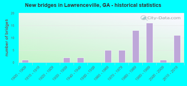
- New bridges - historical statistics
- 11900-1909
- 21930-1939
- 21940-1949
- 51960-1969
- 51970-1979
- 131980-1989
- 161990-1999
- 12000-2009
- 112010-2019

- Reconstructed bridges - Historical Statistics
- 21970-1979
- 41980-1989
- 21990-1999


- Bridge Condition - Deck
- 15.8%Very good
- 76.3%Good
- 7.9%Satisfactory

- Bridge Condition - Superstructure
- 68.4%Very good
- 26.3%Good
- 5.3%Satisfactory

- Bridge Condition - Substructure
- 21.1%Very good
- 68.4%Good
- 10.5%Satisfactory

- Bridge Condition - Channel
- 2.7%Excellent
- 40.5%Very good
- 32.4%Good
- 8.1%Satisfactory
- 16.2%Fair

- Bridge Condition - Culverts
- 88.9%Good
- 11.1%Satisfactory
Find on map >> Show street view
Structure Number: 1350003, Location: 3.5 MI SW OF LAWRENCEVILL (Lat: 33.930561, Lng: -84.045853), Route carried "on" structure: US 29, Year Built: 1972, Year Reconstructed: 1987, Status: Open, Structure Length: 4.69m (15.39ft), Average Daily Traffic: 24,270 (year 2012), Truck Traffic: 1%, Average Future Daily Traffic: 36,405 (year 2032), Design Load: HS 20+Mod, Features Intersected: YELLOW RIVER
Minimum Vertical Clearance: 30+ m (98+ ft), Kilometerpoint: 16.093, Lanes on structure: 5, Base Highway Network: Yes, Owner: State Highway Agency, Approaching Roadway Width: 21.3m (69.9ft), Material/Design: Concrete, Design/Construction: Tee Beam, Number Of Spans In Main Unit: 5, Length of Maximum Span: 12.2m (40.0ft), Curb-To-Curb Width: 24.6m (80.7ft), Out-to-Out Width: 25.5m (83.7ft)
Condition: Deck: Good, Superstructure: Good, Substructure: Good, Channel: Very good, Operating Rating: 68.9 metric tons, Method Used To Determine Operating Rating: Load Factor (LF), Inventory Rating: 40.8 metric tons, Method Used To Determine Inventory Rating: Load Factor (LF), Structural Evaluation: Better than present minimum criteria, Deck Geometry: Superior to present desirable criteria, Waterway Adequacy: Equal to present desirable criteria, Approach Roadway Alignment: Equal to present desirable criteria, Designated Inspection Frequency: Every 24 months, Inspection Date: October 2021, Bridge Improvement Cost: $1,094,000, Roadway Improvement Cost: $109,000, Total Project Cost: $1,641,000, Deck Structure Type: Concrete Cast-file-Place
Find on map >> Show street view
Structure Number: 1350004, Location: 2.7 MI SW OF LAWRENCEVILL (Lat: 33.938581, Lng: -84.029728), Route carried "on" structure: US 29, Year Built: 1947, Year Reconstructed: 1988, Status: Open, Structure Length: 4.11m (13.48ft), Average Daily Traffic: 22,020 (year 2012), Truck Traffic: 1%, Average Future Daily Traffic: 33,030 (year 2032), Design Load: H 15, Features Intersected: CSX RAILROAD
Minimum Vertical Clearance: 30+ m (98+ ft), Kilometerpoint: 17.703, Lanes on structure: 5, Owner: State Highway Agency, Approaching Roadway Width: 18.0m (59.1ft), Skew: 23 degrees, Material/Design: Steel, Design/Construction: Stringer/Multi-beam, Number Of Spans In Main Unit: 3, Length of Maximum Span: 14.0m (45.9ft), Curb or Sidewalk Widths: Left: 0.2m (0.7ft), Right: 0.2m (0.7ft), Curb-To-Curb Width: 25.0m (82.0ft), Out-to-Out Width: 25.9m (85.0ft)
Condition: Deck: Good, Superstructure: Very good, Substructure: Good, Operating Rating: 39.9 metric tons, Method Used To Determine Operating Rating: Load Factor (LF), Inventory Rating: 23.5 metric tons, Method Used To Determine Inventory Rating: Load Factor (LF), Structural Evaluation: Somewhat better than minimum adequacy, Deck Geometry: Superior to present desirable criteria, Underclear: Meets minimum limits, Approach Roadway Alignment: Equal to present minimum criteria, Designated Inspection Frequency: Every 24 months, Inspection Date: January 2022, Bridge Improvement Cost: $959,000, Roadway Improvement Cost: $96,000, Total Project Cost: $1,439,000, Deck Structure Type: Concrete Cast-file-Place
Find on map >> Show street view
Structure Number: 1350005, Location: 2.7 MI SW OF LAWRENCEVILL (Lat: 33.938450, Lng: -84.028539), Route carried "on" structure: US 29, Year Built: 1942, Year Reconstructed: 1988, Status: Open, Structure Length: 0.64m (2.10ft), Average Daily Traffic: 22,020 (year 2012), Truck Traffic: 1%, Average Future Daily Traffic: 33,030 (year 2032), Design Load: H 15, Features Intersected: REDLAND CREEK
Minimum Vertical Clearance: 30+ m (98+ ft), Kilometerpoint: 19.312, Lanes on structure: 4, Base Highway Network: Yes, Owner: State Highway Agency, Approaching Roadway Width: 18.0m (59.1ft), Skew: 20 degrees, Material/Design: Concrete, Design/Construction: Culvert, Number Of Spans In Main Unit: 2, Length of Maximum Span: 3.0m (9.8ft)
Condition: Channel: Good, Culverts: Satisfactory, Structural Evaluation: Equal to present minimum criteria, Waterway Adequacy: Equal to present desirable criteria, Approach Roadway Alignment: Equal to present desirable criteria, Designated Inspection Frequency: Every 24 months, Inspection Date: October 2021, Bridge Improvement Cost: $127,000, Roadway Improvement Cost: $13,000, Total Project Cost: $190,000
Find on map >> Show street view
Structure Number: 1350013, Location: IN LAWRENCEVILLE (Lat: 33.961711, Lng: -83.985656), Route carried "on" structure: State highway 20, Year Built: 1976, Year Reconstructed: 2003, Status: Open, Structure Length: 3.96m (12.99ft), Average Daily Traffic: 25,730 (year 2012), Truck Traffic: 1%, Average Future Daily Traffic: 38,595 (year 2032), Design Load: HS 20+Mod, Features Intersected: CSX RAILROAD, Facility Carried by Structure: LAWRENCEVILLE HWY
Minimum Vertical Clearance: 30+ m (98+ ft), Kilometerpoint: 25.750, Lanes on structure: 5, Base Highway Network: Yes, Owner: State Highway Agency, Approaching Roadway Width: 19.5m (64.0ft), Material/Design: Steel, Design/Construction: Stringer/Multi-beam, Number Of Spans In Main Unit: 3, Length of Maximum Span: 17.1m (56.1ft), Curb or Sidewalk Widths: Left: 1.8m (5.9ft), Right: 1.8m (5.9ft), Curb-To-Curb Width: 18.3m (60.0ft), Out-to-Out Width: 22.6m (74.1ft)
Condition: Deck: Good, Superstructure: Good, Substructure: Good, Operating Rating: 43.5 metric tons, Method Used To Determine Operating Rating: Allowable Stress (AS), Inventory Rating: 25.4 metric tons, Method Used To Determine Inventory Rating: Allowable Stress (AS), Structural Evaluation: Equal to present minimum criteria, Deck Geometry: High priority of replacement, Underclear: Equal to present minimum criteria, Approach Roadway Alignment: Equal to present desirable criteria, Designated Inspection Frequency: Every 24 months, Inspection Date: September 2021, Bridge Improvement Cost: $924,000, Roadway Improvement Cost: $92,000, Total Project Cost: $1,385,000, Deck Structure Type: Concrete Cast-file-Place
Find on map >> Show street view
Structure Number: 1350025, Location: 1.5 MI NW OF LAWRENCEVILL (Lat: 33.967842, Lng: -84.037692), Route carried "on" structure: State highway 120, Year Built: 1974, Status: Open, Structure Length: 0.73m (2.40ft), Average Daily Traffic: 24,500 (year 2012), Truck Traffic: 1%, Average Future Daily Traffic: 36,750 (year 2032), Design Load: HS 20+Mod, Features Intersected: WOLF CREEK
Minimum Vertical Clearance: 30+ m (98+ ft), Kilometerpoint: 14.484, Lanes on structure: 5, Base Highway Network: Yes, Owner: State Highway Agency, Approaching Roadway Width: 20.7m (67.9ft), Skew: 23 degrees, Material/Design: Concrete, Design/Construction: Culvert, Number Of Spans In Main Unit: 3, Length of Maximum Span: 3.7m (12.1ft)
Condition: Channel: Good, Culverts: Good, Operating Rating: 55.3 metric tons, Method Used To Determine Operating Rating: Field evaluation and documented engineering judgment, Inventory Rating: 32.6 metric tons, Method Used To Determine Inventory Rating: Field evaluation and documented engineering judgment, Structural Evaluation: Better than present minimum criteria, Waterway Adequacy: Equal to present desirable criteria, Approach Roadway Alignment: Equal to present minimum criteria, Designated Inspection Frequency: Every 24 months, Inspection Date: September 2021, Bridge Improvement Cost: $170,000, Roadway Improvement Cost: $17,000, Total Project Cost: $256,000
Find on map >> Show street view
Structure Number: 1350026, Location: 1.2 MI W OF LAWRENCEVILLE (Lat: 33.968850, Lng: -84.030811), Route carried "on" structure: State highway 120, Year Built: 1902, Year Reconstructed: 1996, Status: Open, Structure Length: 2.62m (8.60ft), Average Daily Traffic: 24,500 (year 2012), Truck Traffic: 1%, Average Future Daily Traffic: 36,750 (year 2032), Design Load: H 15, Features Intersected: YELLOW RIVER
Minimum Vertical Clearance: 30+ m (98+ ft), Kilometerpoint: 16.093, Lanes on structure: 4, Base Highway Network: Yes, Owner: State Highway Agency, Approaching Roadway Width: 17.1m (56.1ft), Skew: 20 degrees, Material/Design: Steel, Design/Construction: Stringer/Multi-beam, Number Of Spans In Main Unit: 2, Length of Maximum Span: 13.1m (43.0ft), Curb or Sidewalk Widths: Left: 1.8m (5.9ft), Right: 1.8m (5.9ft), Curb-To-Curb Width: 21.9m (71.9ft), Out-to-Out Width: 26.4m (86.6ft)
Condition: Deck: Good, Superstructure: Satisfactory, Substructure: Satisfactory, Channel: Good, Operating Rating: 48.9 metric tons, Method Used To Determine Operating Rating: Load Factor (LF), Inventory Rating: 29.0 metric tons, Method Used To Determine Inventory Rating: Load Factor (LF), Structural Evaluation: Equal to present minimum criteria, Deck Geometry: Superior to present desirable criteria, Waterway Adequacy: Equal to present minimum criteria, Approach Roadway Alignment: Better than present minimum criteria, Designated Inspection Frequency: Every 24 months, Inspection Date: September 2021, Bridge Improvement Cost: $519,000, Roadway Improvement Cost: $52,000, Total Project Cost: $779,000, Deck Structure Type: Concrete Cast-file-Place
Find on map >> Show street view
Structure Number: 1350027, Location: .5 MI W OF LAWRENCEVILLE (Lat: 33.967200, Lng: -84.016503), Route carried "on" structure: State highway 120, Year Built: 1960, Year Reconstructed: 1979, Status: Open, Structure Length: 8.41m (27.59ft), Average Daily Traffic: 22,020 (year 2012), Truck Traffic: 1%, Average Future Daily Traffic: 33,030 (year 2032), Design Load: HS 20+Mod, Features Intersected: SR 316
Minimum Vertical Clearance: 30+ m (98+ ft), Kilometerpoint: 17.703, Lanes on structure: 5, Lanes under structure: 4, Owner: State Highway Agency, Approaching Roadway Width: 14.6m (47.9ft), Skew: 3 degrees, Material/Design: Concrete continuous, Design/Construction: Tee Beam, Number Of Spans In Main Unit: 4, Length of Maximum Span: 23.5m (77.1ft), Curb or Sidewalk Widths: Left: 1.8m (5.9ft), Right: 1.8m (5.9ft), Curb-To-Curb Width: 20.2m (66.3ft), Out-to-Out Width: 24.4m (80.1ft)
Condition: Deck: Good, Superstructure: Good, Substructure: Good, Operating Rating: 45.3 metric tons, Method Used To Determine Operating Rating: Allowable Stress (AS), Inventory Rating: 32.6 metric tons, Method Used To Determine Inventory Rating: Allowable Stress (AS), Structural Evaluation: Better than present minimum criteria, Deck Geometry: Somewhat better than minimum adequacy, Underclear: Equal to present minimum criteria, Approach Roadway Alignment: Equal to present minimum criteria, Designated Inspection Frequency: Every 24 months, Inspection Date: January 2022, Bridge Improvement Cost: $1,961,000, Roadway Improvement Cost: $196,000, Total Project Cost: $2,941,000, Deck Structure Type: Concrete Cast-file-Place, Wearing Surface/Protective System: Wearing Surface: Bituminous
Find on map >> Show street view
Structure Number: 1350028, Location: IN LAWRENCEVILLE CITY LMT (Lat: 33.959628, Lng: -84.003747), Route carried "on" structure: State highway 120, Year Built: 1937, Year Reconstructed: 1981, Status: Open, Structure Length: 4.08m (13.39ft), Average Daily Traffic: 44,430 (year 2012), Truck Traffic: 1%, Average Future Daily Traffic: 66,645 (year 2032), Design Load: H 15, Features Intersected: CSX RAILROAD
Minimum Vertical Clearance: 30+ m (98+ ft), Kilometerpoint: 19.312, Lanes on structure: 5, Base Highway Network: Yes, Owner: State Highway Agency, Approaching Roadway Width: 20.1m (65.9ft), Material/Design: Steel, Design/Construction: Stringer/Multi-beam, Number Of Spans In Main Unit: 3, Length of Maximum Span: 14.0m (45.9ft), Curb or Sidewalk Widths: Left: 1.5m (4.9ft), Right: 1.5m (4.9ft), Curb-To-Curb Width: 20.1m (65.9ft), Out-to-Out Width: 23.8m (78.1ft)
Condition: Deck: Good, Superstructure: Good, Substructure: Satisfactory, Operating Rating: 34.4 metric tons, Method Used To Determine Operating Rating: Load Factor (LF), Inventory Rating: 19.9 metric tons, Method Used To Determine Inventory Rating: Load Factor (LF), Structural Evaluation: Somewhat better than minimum adequacy, Deck Geometry: Somewhat better than minimum adequacy, Underclear: Meets minimum limits, Approach Roadway Alignment: Equal to present minimum criteria, Designated Inspection Frequency: Every 24 months, Inspection Date: September 2021, Bridge Improvement Cost: $952,000, Roadway Improvement Cost: $95,000, Total Project Cost: $1,428,000, Deck Structure Type: Concrete Cast-file-Place, Wearing Surface/Protective System: Wearing Surface: Bituminous
Find on map >> Show street view
Structure Number: 135003, Location: 2 MI S OF LAWRENCEVILLE (Lat: 33.910608, Lng: -84.002078), Route carried "on" structure: State highway 124, Year Built: 1939, Year Reconstructed: 1992, Status: Open, Structure Length: 1.01m (3.31ft), Average Daily Traffic: 36,440 (year 2012), Truck Traffic: 3%, Average Future Daily Traffic: 54,660 (year 2032), Design Load: H 15, Features Intersected: YELLOW RIVER TRIB
Minimum Vertical Clearance: 30+ m (98+ ft), Kilometerpoint: 17.703, Lanes on structure: 5, Base Highway Network: Yes, Owner: State Highway Agency, Approaching Roadway Width: 21.6m (70.9ft), Skew: 21 degrees, Material/Design: Concrete, Design/Construction: Culvert, Number Of Spans In Main Unit: 3, Length of Maximum Span: 3.0m (9.8ft)
Condition: Channel: Satisfactory, Culverts: Good, Inventory Rating: 87.0 metric tons, Method Used To Determine Inventory Rating: Load Factor (LF), Structural Evaluation: Better than present minimum criteria, Waterway Adequacy: Equal to present minimum criteria, Approach Roadway Alignment: Equal to present desirable criteria, Designated Inspection Frequency: Every 24 months, Inspection Date: October 2021, Bridge Improvement Cost: $234,000, Roadway Improvement Cost: $23,000, Total Project Cost: $352,000
Find on map >> Show street view
Structure Number: 1350039, Location: 7.4 MI W OF LAWRENCEVILLE (Lat: 33.961936, Lng: -84.073606), Route carried "on" structure: State highway 316, Year Built: 1960, Status: Open, Structure Length: 0.73m (2.40ft), Average Daily Traffic: 87,580 (year 2012), Truck Traffic: 1%, Average Future Daily Traffic: 131,370 (year 2032), Design Load: HS 20+Mod, Features Intersected: FORK CREEK TRIB
Minimum Vertical Clearance: 30+ m (98+ ft), Kilometerpoint: 3.219, Lanes on structure: 4, Base Highway Network: Yes, Owner: State Highway Agency, Approaching Roadway Width: 21.9m (71.9ft), Skew: 13 degrees, Material/Design: Concrete, Design/Construction: Culvert, Number Of Spans In Main Unit: 2, Length of Maximum Span: 3.7m (12.1ft)
Condition: Channel: Good, Culverts: Good, Operating Rating: 55.3 metric tons, Method Used To Determine Operating Rating: Field evaluation and documented engineering judgment, Inventory Rating: 32.6 metric tons, Method Used To Determine Inventory Rating: Field evaluation and documented engineering judgment, Structural Evaluation: Better than present minimum criteria, Waterway Adequacy: Equal to present desirable criteria, Approach Roadway Alignment: Equal to present desirable criteria, Designated Inspection Frequency: Every 24 months, Inspection Date: October 2021, Bridge Improvement Cost: $145,000, Roadway Improvement Cost: $14,000, Total Project Cost: $217,000
Find on map >> Show street view
Structure Number: 135004, Location: 2.5 MI W OF LAWRENCEVILLE (Lat: 33.958897, Lng: -84.038133), Route carried "on" structure: State highway 316, Year Built: 1960, Status: Open, Structure Length: 4.75m (15.58ft), Average Daily Traffic: 78,840 (year 2012), Truck Traffic: 1%, Average Future Daily Traffic: 118,260 (year 2032), Design Load: HS 20+Mod, Features Intersected: YELLOW RIVER
Minimum Vertical Clearance: 30+ m (98+ ft), Kilometerpoint: 6.437, Lanes on structure: 2, Base Highway Network: Yes, Owner: State Highway Agency, Approaching Roadway Width: 11.3m (37.1ft), Skew: 10 degrees, Material/Design: Steel, Design/Construction: Stringer/Multi-beam, Number Of Spans In Main Unit: 3, Length of Maximum Span: 15.8m (51.8ft), Curb or Sidewalk Widths: Left: 0.6m (2.0ft), Right: 0.6m (2.0ft), Curb-To-Curb Width: 8.5m (27.9ft), Out-to-Out Width: 9.8m (32.2ft)
Condition: Deck: Satisfactory, Superstructure: Good, Substructure: Satisfactory, Channel: Fair, Operating Rating: 47.1 metric tons, Method Used To Determine Operating Rating: Load Factor (LF), Inventory Rating: 28.1 metric tons, Method Used To Determine Inventory Rating: Load Factor (LF), Structural Evaluation: Equal to present minimum criteria, Deck Geometry: High priority of replacement, Waterway Adequacy: Equal to present desirable criteria, Approach Roadway Alignment: Equal to present desirable criteria, Length Of Structure Improvement: 11.19m (36.71ft), Designated Inspection Frequency: Every 24 months, Inspection Date: October 2021, Bridge Improvement Cost: $610,000, Roadway Improvement Cost: $61,000, Total Project Cost: $914,000, Deck Structure Type: Concrete Cast-file-Place
Find on map >> Show street view
Structure Number: 1350041, Location: 2.5 MI W OF LAWRENCEVILLE (Lat: 33.959067, Lng: -84.038167), Route carried "on" structure: State highway 316, Year Built: 1960, Status: Open, Structure Length: 4.75m (15.58ft), Average Daily Traffic: 78,840 (year 2012), Truck Traffic: 1%, Average Future Daily Traffic: 118,260 (year 2032), Design Load: HS 20+Mod, Features Intersected: YELLOW RIVER
Minimum Vertical Clearance: 30+ m (98+ ft), Kilometerpoint: 6.437, Lanes on structure: 2, Base Highway Network: Yes, Owner: State Highway Agency, Approaching Roadway Width: 11.0m (36.1ft), Skew: 10 degrees, Material/Design: Steel, Design/Construction: Stringer/Multi-beam, Number Of Spans In Main Unit: 3, Length of Maximum Span: 15.8m (51.8ft), Curb or Sidewalk Widths: Left: 0.6m (2.0ft), Right: 0.6m (2.0ft), Curb-To-Curb Width: 8.5m (27.9ft), Out-to-Out Width: 9.8m (32.2ft)
Condition: Deck: Satisfactory, Superstructure: Good, Substructure: Satisfactory, Channel: Fair, Operating Rating: 40.8 metric tons, Method Used To Determine Operating Rating: Load Factor (LF), Inventory Rating: 24.4 metric tons, Method Used To Determine Inventory Rating: Load Factor (LF), Structural Evaluation: Equal to present minimum criteria, Deck Geometry: High priority of replacement, Waterway Adequacy: Equal to present desirable criteria, Approach Roadway Alignment: Equal to present desirable criteria, Length Of Structure Improvement: 11.19m (36.71ft), Designated Inspection Frequency: Every 24 months, Inspection Date: October 2021, Bridge Improvement Cost: $610,000, Roadway Improvement Cost: $61,000, Total Project Cost: $914,000, Deck Structure Type: Concrete Cast-file-Place
Find on map >> Show street view
Structure Number: 135006, Location: 3.8 MI SE OF DULUTH (Lat: 33.962608, Lng: -84.079478), Route carried "on" structure: County highway 544, Year Built: 1960, Status: Open, Structure Length: 6.40m (21.00ft), Average Daily Traffic: 1,930 (year 2012), Truck Traffic: 1%, Average Future Daily Traffic: 2,895 (year 2032), Design Load: H 15, Features Intersected: SR 316, Facility Carried by Structure: HERRINGTON ROAD
Minimum Vertical Clearance: 30+ m (98+ ft), Kilometerpoint: 3.219, Lanes on structure: 2, Lanes under structure: 4, Base Highway Network: Yes, Owner: State Highway Agency, Approaching Roadway Width: 6.7m (22.0ft), Material/Design: Concrete continuous, Design/Construction: Tee Beam, Number Of Spans In Main Unit: 4, Length of Maximum Span: 18.3m (60.0ft), Curb or Sidewalk Widths: Left: 0.6m (2.0ft), Right: 0.6m (2.0ft), Curb-To-Curb Width: 7.9m (25.9ft), Out-to-Out Width: 9.9m (32.5ft)
Condition: Deck: Satisfactory, Superstructure: Satisfactory, Substructure: Good, Operating Rating: 27.2 metric tons, Method Used To Determine Operating Rating: Allowable Stress (AS), Inventory Rating: 17.2 metric tons, Method Used To Determine Inventory Rating: Allowable Stress (AS), Structural Evaluation: Meets minimum limits, Deck Geometry: Meets minimum limits, Underclear: Equal to present minimum criteria, Approach Roadway Alignment: Equal to present desirable criteria, Designated Inspection Frequency: Every 24 months, Inspection Date: October 2021, Bridge Improvement Cost: $821,000, Roadway Improvement Cost: $82,000, Total Project Cost: $1,231,000, Deck Structure Type: Concrete Cast-file-Place
Find on map >> Show street view
Structure Number: 1350068, Location: 2.5 MI N OF LAWRENCEVILLE (Lat: 33.978039, Lng: -84.020008), Route carried "on" structure: City street 9466, Year Built: 1989, Status: Open, Structure Length: 1.83m (6.00ft), Average Daily Traffic: 24,920 (year 2012), Truck Traffic: 1%, Average Future Daily Traffic: 37,380 (year 2032), Design Load: HS 20+Mod, Features Intersected: YELLOW RIVER, Facility Carried by Structure: LVILLE-SUWANEE RD
Minimum Vertical Clearance: 30+ m (98+ ft), Kilometerpoint: 4.828, Lanes on structure: 4, Base Highway Network: Yes, Owner: County Highway Agency, Approaching Roadway Width: 17.1m (56.1ft), Skew: 20 degrees, Material/Design: Prestressed concrete, Design/Construction: Stringer/Multi-beam, Number Of Spans In Main Unit: 1, Length of Maximum Span: 18.3m (60.0ft), Curb or Sidewalk Widths: Left: 1.8m (5.9ft), Right: 1.8m (5.9ft), Curb-To-Curb Width: 18.9m (62.0ft), Out-to-Out Width: 23.2m (76.1ft)
Condition: Deck: Good, Superstructure: Very good, Substructure: Good, Channel: Good, Operating Rating: 46.2 metric tons, Method Used To Determine Operating Rating: Allowable Stress (AS), Inventory Rating: 32.6 metric tons, Method Used To Determine Inventory Rating: Allowable Stress (AS), Structural Evaluation: Better than present minimum criteria, Deck Geometry: Equal to present minimum criteria, Waterway Adequacy: Equal to present desirable criteria, Approach Roadway Alignment: Equal to present desirable criteria, Designated Inspection Frequency: Every 24 months, Inspection Date: September 2021, Bridge Improvement Cost: $362,000, Roadway Improvement Cost: $36,000, Total Project Cost: $543,000, Deck Structure Type: Concrete Cast-file-Place
Find on map >> Show street view
Structure Number: 1350078, Location: 4 MI SW OF LAWRENCEVILLE (Lat: 33.910119, Lng: -84.034308), Route carried "on" structure: County highway 9294, Year Built: 1978, Status: Open, Structure Length: 0.94m (3.08ft), Average Daily Traffic: 15,870 (year 2012), Truck Traffic: 1%, Average Future Daily Traffic: 23,805 (year 2032), Design Load: HS 20+Mod, Features Intersected: PUGHS CREEK, Facility Carried by Structure: FIVE FORKS TRICKUM
Minimum Vertical Clearance: 30+ m (98+ ft), Kilometerpoint: 12.875, Lanes on structure: 2, Base Highway Network: Yes, Owner: County Highway Agency, Approaching Roadway Width: 8.2m (26.9ft), Skew: 2 degrees, Material/Design: Concrete, Design/Construction: Culvert, Number Of Spans In Main Unit: 3, Length of Maximum Span: 3.0m (9.8ft)
Condition: Channel: Satisfactory, Culverts: Good, Operating Rating: 55.3 metric tons, Method Used To Determine Operating Rating: Field evaluation and documented engineering judgment, Inventory Rating: 32.6 metric tons, Method Used To Determine Inventory Rating: Field evaluation and documented engineering judgment, Structural Evaluation: Better than present minimum criteria, Waterway Adequacy: Equal to present minimum criteria, Approach Roadway Alignment: Better than present minimum criteria, Designated Inspection Frequency: Every 24 months, Inspection Date: October 2021, Bridge Improvement Cost: $121,000, Roadway Improvement Cost: $12,000, Total Project Cost: $182,000
Find on map >> Show street view
Structure Number: 1350086, Location: 3.1 MI W OF LAWRENCEVILLE (Lat: 33.953758, Lng: -84.041228), Route carried "on" structure: City street 9417, Year Built: 1988, Status: Open, Structure Length: 3.81m (12.50ft), Average Daily Traffic: 15,240 (year 2012), Truck Traffic: 1%, Average Future Daily Traffic: 22,860 (year 2032), Design Load: HS 20+Mod, Features Intersected: YELLOW RIVER, Facility Carried by Structure: OLD NORCROSS-LVILL
Minimum Vertical Clearance: 30+ m (98+ ft), Kilometerpoint: 11.265, Lanes on structure: 5, Base Highway Network: Yes, Owner: County Highway Agency, Approaching Roadway Width: 17.1m (56.1ft), Skew: 11 degrees, Material/Design: Prestressed concrete, Design/Construction: Stringer/Multi-beam, Number Of Spans In Main Unit: 2, Length of Maximum Span: 22.9m (75.1ft), Curb or Sidewalk Widths: Left: 1.5m (4.9ft), Right: 0.0m, Curb-To-Curb Width: 17.7m (58.1ft), Out-to-Out Width: 20.5m (67.3ft)
Condition: Deck: Good, Superstructure: Very good, Substructure: Very good, Channel: Very good, Operating Rating: 74.3 metric tons, Method Used To Determine Operating Rating: Load Factor (LF), Inventory Rating: 35.3 metric tons, Method Used To Determine Inventory Rating: Load Factor (LF), Structural Evaluation: Equal to present desirable criteria, Deck Geometry: High priority of replacement, Waterway Adequacy: Equal to present desirable criteria, Approach Roadway Alignment: Equal to present desirable criteria, Designated Inspection Frequency: Every 24 months, Inspection Date: October 2021, Bridge Improvement Cost: $888,000, Roadway Improvement Cost: $89,000, Total Project Cost: $1,332,000, Deck Structure Type: Concrete Cast-file-Place
Find on map >> Show street view
Structure Number: 1350097, Location: 3.2 MI N OF LAWRENCEVILLE (Lat: 33.984456, Lng: -83.950731), Route carried "on" structure: State highway 316, Year Built: 1982, Status: Open, Structure Length: 0.88m (2.89ft), Average Daily Traffic: 41,060 (year 2012), Truck Traffic: 10%, Average Future Daily Traffic: 61,590 (year 2032), Design Load: HS 20+Mod, Features Intersected: ALCOVY RIVER
Minimum Vertical Clearance: 30+ m (98+ ft), Kilometerpoint: 14.484, Lanes on structure: 4, Base Highway Network: Yes, Owner: State Highway Agency, Approaching Roadway Width: 19.5m (64.0ft), Skew: 10 degrees, Material/Design: Concrete, Design/Construction: Culvert, Number Of Spans In Main Unit: 3, Length of Maximum Span: 2.7m (8.9ft)
Condition: Channel: Fair, Culverts: Good, Structural Evaluation: Better than present minimum criteria, Waterway Adequacy: Equal to present desirable criteria, Approach Roadway Alignment: Better than present minimum criteria, Designated Inspection Frequency: Every 24 months, Inspection Date: January 2022, Bridge Improvement Cost: $175,000, Roadway Improvement Cost: $18,000, Total Project Cost: $263,000
Find on map >> Show street view
Structure Number: 135011, Location: 1.3 MI W OF NORCROSS (Lat: 33.943928, Lng: -84.240578), Route carried "on" structure: State highway 141, Year Built: 1988, Status: Open, Structure Length: 6.77m (22.21ft), Average Daily Traffic: 73,000 (year 2012), Truck Traffic: 1%, Average Future Daily Traffic: 109,500 (year 2032), Design Load: HS 20+Mod, Features Intersected: SR 140-SR 141 U-TURN RMP, Facility Carried by Structure: P'TREE IND BLVD
Minimum Vertical Clearance: 30+ m (98+ ft), Kilometerpoint: 3.219, Lanes on structure: 6, Lanes under structure: 7, Base Highway Network: Yes, Owner: State Highway Agency, Approaching Roadway Width: 32.3m (106.0ft), Skew: 30 degrees, Material/Design: Steel continuous, Design/Construction: Stringer/Multi-beam, Number Of Spans In Main Unit: 2, Length of Maximum Span: 45.1m (148.0ft), Curb-To-Curb Width: 32.9m (107.9ft), Out-to-Out Width: 33.9m (111.2ft)
Condition: Deck: Good, Superstructure: Very good, Substructure: Good, Operating Rating: 34.4 metric tons, Method Used To Determine Operating Rating: Load Factor (LF), Inventory Rating: 19.9 metric tons, Method Used To Determine Inventory Rating: Load Factor (LF), Structural Evaluation: Somewhat better than minimum adequacy, Deck Geometry: Superior to present desirable criteria, Underclear: Equal to present minimum criteria, Approach Roadway Alignment: Equal to present desirable criteria, Designated Inspection Frequency: Every 24 months, Inspection Date: January 2022, Bridge Improvement Cost: $1,814,000, Roadway Improvement Cost: $181,000, Total Project Cost: $2,720,000, Deck Structure Type: Concrete Cast-file-Place
Find on map >> Show street view
Structure Number: 1350111, Location: 6.5 MI SE OF DULUTH (Lat: 33.952578, Lng: -84.092869), Route carried "on" structure: City street 9462, Year Built: 1987, Status: Open, Structure Length: 1.34m (4.40ft), Average Daily Traffic: 18,190 (year 2012), Truck Traffic: 1%, Average Future Daily Traffic: 27,285 (year 2032), Design Load: HS 20+Mod, Features Intersected: FORK CREEK, Facility Carried by Structure: BOGGS ROAD
Minimum Vertical Clearance: 30+ m (98+ ft), Kilometerpoint: 0.000, Lanes on structure: 5, Base Highway Network: Yes, Owner: County Highway Agency, Approaching Roadway Width: 18.9m (62.0ft), Material/Design: Concrete, Design/Construction: Culvert, Number Of Spans In Main Unit: 4, Length of Maximum Span: 3.0m (9.8ft)
Condition: Channel: Very good, Culverts: Good, Operating Rating: 55.3 metric tons, Method Used To Determine Operating Rating: Field evaluation and documented engineering judgment, Inventory Rating: 32.6 metric tons, Method Used To Determine Inventory Rating: Field evaluation and documented engineering judgment, Structural Evaluation: Better than present minimum criteria, Waterway Adequacy: Equal to present desirable criteria, Approach Roadway Alignment: Equal to present desirable criteria, Designated Inspection Frequency: Every 24 months, Inspection Date: September 2021, Bridge Improvement Cost: $313,000, Roadway Improvement Cost: $31,000, Total Project Cost: $469,000
Find on map >> Show street view
Structure Number: 1350115, Location: IN LAWRENCEVILLE (Lat: 33.956272, Lng: -83.994017), Route carried "on" structure: US 29, Year Built: 1989, Status: Open, Structure Length: 4.75m (15.58ft), Average Daily Traffic: 5,580 (year 2012), Truck Traffic: 1%, Average Future Daily Traffic: 8,370 (year 2032), Design Load: HS 20+Mod, Features Intersected: SR 120 EBL
Minimum Vertical Clearance: 30+ m (98+ ft), Kilometerpoint: 22.531, Lanes on structure: 2, Lanes under structure: 2, Base Highway Network: Yes, Owner: State Highway Agency, Approaching Roadway Width: 7.9m (25.9ft), Material/Design: Prestressed concrete, Design/Construction: Stringer/Multi-beam, Number Of Spans In Main Unit: 3, Length of Maximum Span: 20.1m (65.9ft), Curb-To-Curb Width: 11.6m (38.1ft), Out-to-Out Width: 12.5m (41.0ft)
Condition: Deck: Good, Superstructure: Very good, Substructure: Good, Operating Rating: 48.0 metric tons, Method Used To Determine Operating Rating: Load Factor (LF), Inventory Rating: 28.1 metric tons, Method Used To Determine Inventory Rating: Load Factor (LF), Structural Evaluation: Better than present minimum criteria, Deck Geometry: Better than present minimum criteria, Underclear: Somewhat better than minimum adequacy, Approach Roadway Alignment: Equal to present minimum criteria, Designated Inspection Frequency: Every 24 months, Inspection Date: September 2021, Bridge Improvement Cost: $610,000, Roadway Improvement Cost: $61,000, Total Project Cost: $914,000, Deck Structure Type: Concrete Cast-file-Place
Find on map >> Show street view
Structure Number: 1355015, Location: 3.8 MI SE OF SUWANEE (Lat: 34.016858, Lng: -84.014708), Route carried "on" structure: County highway 104, Year Built: 1989, Status: Open, Structure Length: 0.70m (2.30ft), Average Daily Traffic: 9,790 (year 2012), Truck Traffic: 1%, Average Future Daily Traffic: 14,685 (year 2032), Design Load: HS 20+Mod, Features Intersected: LITTLE SUWANEE CREEK, Facility Carried by Structure: COLLINS HILL ROAD
Minimum Vertical Clearance: 30+ m (98+ ft), Kilometerpoint: 6.437, Lanes on structure: 2, Base Highway Network: Yes, Owner: County Highway Agency, Approaching Roadway Width: 8.2m (26.9ft), Skew: 3 degrees, Material/Design: Concrete, Design/Construction: Culvert, Number Of Spans In Main Unit: 3, Length of Maximum Span: 2.1m (6.9ft), Curb or Sidewalk Widths: Left: 1.2m (3.9ft), Right: 0.0m
Condition: Channel: Very good, Culverts: Good, Operating Rating: 55.3 metric tons, Method Used To Determine Operating Rating: Field evaluation and documented engineering judgment, Inventory Rating: 32.6 metric tons, Method Used To Determine Inventory Rating: Field evaluation and documented engineering judgment, Structural Evaluation: Better than present minimum criteria, Waterway Adequacy: Equal to present desirable criteria, Approach Roadway Alignment: Equal to present desirable criteria, Designated Inspection Frequency: Every 24 months, Inspection Date: November 2021, Bridge Improvement Cost: $90,000, Roadway Improvement Cost: $9,000, Total Project Cost: $135,000
Find on map >> Show street view
Structure Number: 1355016, Location: 2 MI NW OF LAWRENCEVILLE (Lat: 33.988058, Lng: -84.010328), Route carried "on" structure: County highway 104, Year Built: 1986, Status: Open, Structure Length: 0.64m (2.10ft), Average Daily Traffic: 9,790 (year 2012), Truck Traffic: 1%, Average Future Daily Traffic: 14,685 (year 2032), Design Load: HS 20+Mod, Features Intersected: YELLOW RIVER, Facility Carried by Structure: COLLINS HILL ROAD
Minimum Vertical Clearance: 30+ m (98+ ft), Kilometerpoint: 9.656, Lanes on structure: 2, Base Highway Network: Yes, Owner: County Highway Agency, Approaching Roadway Width: 8.2m (26.9ft), Material/Design: Concrete, Design/Construction: Culvert, Number Of Spans In Main Unit: 2, Length of Maximum Span: 3.0m (9.8ft)
Condition: Channel: Fair, Culverts: Satisfactory, Operating Rating: 55.3 metric tons, Method Used To Determine Operating Rating: Field evaluation and documented engineering judgment, Inventory Rating: 32.6 metric tons, Method Used To Determine Inventory Rating: Field evaluation and documented engineering judgment, Structural Evaluation: Equal to present minimum criteria, Waterway Adequacy: Equal to present desirable criteria, Approach Roadway Alignment: Equal to present desirable criteria, Designated Inspection Frequency: Every 24 months, Inspection Date: November 2021, Bridge Improvement Cost: $82,000, Roadway Improvement Cost: $8,000, Total Project Cost: $123,000
Find on map >> Show street view
Structure Number: 1355036, Location: 2.2 MI E OF LAWRENCEVILLE (Lat: 33.949611, Lng: -83.948489), Route carried "on" structure: County highway 265, Year Built: 1989, Status: Open, Structure Length: 1.98m (6.50ft), Average Daily Traffic: 1,930 (year 2012), Truck Traffic: 1%, Average Future Daily Traffic: 2,895 (year 2032), Design Load: HS 20, Features Intersected: SHOAL CREEK, Facility Carried by Structure: PAPER MILL ROAD
Minimum Vertical Clearance: 30+ m (98+ ft), Kilometerpoint: 1.609, Lanes on structure: 2, Base Highway Network: Yes, Owner: County Highway Agency, Approaching Roadway Width: 7.3m (24.0ft), Material/Design: Concrete, Design/Construction: Culvert, Number Of Spans In Main Unit: 4, Length of Maximum Span: 3.0m (9.8ft)
Condition: Channel: Fair, Culverts: Good, Operating Rating: 55.3 metric tons, Method Used To Determine Operating Rating: Field evaluation and documented engineering judgment, Inventory Rating: 32.6 metric tons, Method Used To Determine Inventory Rating: Field evaluation and documented engineering judgment, Structural Evaluation: Better than present minimum criteria, Waterway Adequacy: Equal to present desirable criteria, Approach Roadway Alignment: Better than present minimum criteria, Designated Inspection Frequency: Every 24 months, Inspection Date: September 2021, Bridge Improvement Cost: $180,000, Roadway Improvement Cost: $18,000, Total Project Cost: $270,000
Find on map >> Show street view
Structure Number: 135504, Location: 2.6 MI E OF LAWRENCEVILLE (Lat: 33.943997, Lng: -83.945581), Route carried "on" structure: County highway 280, Year Built: 1989, Status: Open, Structure Length: 1.98m (6.50ft), Average Daily Traffic: 1,930 (year 2012), Truck Traffic: 1%, Average Future Daily Traffic: 2,895 (year 2032), Design Load: HS 20, Features Intersected: SHOAL CREEK, Facility Carried by Structure: SIMONTON ROAD
Minimum Vertical Clearance: 30+ m (98+ ft), Kilometerpoint: 3.219, Lanes on structure: 2, Base Highway Network: Yes, Owner: County Highway Agency, Approaching Roadway Width: 7.0m (23.0ft), Skew: 1 degrees, Material/Design: Concrete, Design/Construction: Culvert, Number Of Spans In Main Unit: 4, Length of Maximum Span: 3.0m (9.8ft)
Condition: Channel: Very good, Culverts: Good, Operating Rating: 55.3 metric tons, Method Used To Determine Operating Rating: Field evaluation and documented engineering judgment, Inventory Rating: 32.6 metric tons, Method Used To Determine Inventory Rating: Field evaluation and documented engineering judgment, Structural Evaluation: Better than present minimum criteria, Waterway Adequacy: Equal to present desirable criteria, Approach Roadway Alignment: Equal to present desirable criteria, Designated Inspection Frequency: Every 24 months, Inspection Date: September 2021, Bridge Improvement Cost: $176,000, Roadway Improvement Cost: $18,000, Total Project Cost: $264,000
Find on map >> Show street view
Structure Number: 1355064, Location: 5 MI W OF LAWRENCEVILLE (Lat: 33.959303, Lng: -84.076731), Route carried "on" structure: County highway 458, Year Built: 1978, Status: Open, Structure Length: 0.98m (3.22ft), Average Daily Traffic: 1,930 (year 2012), Truck Traffic: 1%, Average Future Daily Traffic: 2,895 (year 2032), Design Load: HS 20+Mod, Features Intersected: FORK CREEK TRIB, Facility Carried by Structure: OAKLAND ROAD
Minimum Vertical Clearance: 30+ m (98+ ft), Kilometerpoint: 4.828, Lanes on structure: 2, Base Highway Network: Yes, Owner: County Highway Agency, Approaching Roadway Width: 8.5m (27.9ft), Material/Design: Concrete, Design/Construction: Culvert, Number Of Spans In Main Unit: 3, Length of Maximum Span: 3.0m (9.8ft)
Condition: Channel: Very good, Culverts: Good, Operating Rating: 55.3 metric tons, Method Used To Determine Operating Rating: Field evaluation and documented engineering judgment, Inventory Rating: 32.6 metric tons, Method Used To Determine Inventory Rating: Field evaluation and documented engineering judgment, Structural Evaluation: Better than present minimum criteria, Waterway Adequacy: Equal to present desirable criteria, Approach Roadway Alignment: Somewhat better than minimum adequacy, Designated Inspection Frequency: Every 24 months, Inspection Date: September 2021, Bridge Improvement Cost: $125,000, Roadway Improvement Cost: $13,000, Total Project Cost: $188,000
Find on map >> Show street view
Structure Number: 1355088, Location: 4.5 MI SW OF LAWRENCEVLLE (Lat: 33.913017, Lng: -84.048886), Route carried "on" structure: County highway 462, Year Built: 1983, Status: Open, Structure Length: 4.88m (16.01ft), Average Daily Traffic: 1,930 (year 2012), Truck Traffic: 1%, Average Future Daily Traffic: 2,895 (year 2032), Design Load: HS 20, Features Intersected: YELLOW RIVER, Facility Carried by Structure: ARNOLD ROAD
Minimum Vertical Clearance: 30+ m (98+ ft), Kilometerpoint: 1.609, Lanes on structure: 2, Base Highway Network: Yes, Owner: County Highway Agency, Approaching Roadway Width: 8.5m (27.9ft), Material/Design: Concrete, Design/Construction: Tee Beam, Number Of Spans In Main Unit: 4, Length of Maximum Span: 12.2m (40.0ft), Curb-To-Curb Width: 12.1m (39.7ft), Out-to-Out Width: 13.0m (42.7ft)
Condition: Deck: Good, Superstructure: Good, Substructure: Good, Channel: Fair, Operating Rating: 53.5 metric tons, Method Used To Determine Operating Rating: Load Factor (LF), Inventory Rating: 31.7 metric tons, Method Used To Determine Inventory Rating: Load Factor (LF), Structural Evaluation: Better than present minimum criteria, Deck Geometry: Equal to present minimum criteria, Waterway Adequacy: Equal to present desirable criteria, Approach Roadway Alignment: Equal to present minimum criteria, Designated Inspection Frequency: Every 24 months, Inspection Date: October 2021, Bridge Improvement Cost: $625,000, Roadway Improvement Cost: $63,000, Total Project Cost: $938,000, Deck Structure Type: Concrete Cast-file-Place
Find on map >> Show street view
Structure Number: 135512, Location: E LAWRENCEVILLE CITY LMT (Lat: 33.950778, Lng: -83.961569), Route carried "on" structure: County highway 265, Year Built: 1987, Status: Open, Structure Length: 0.76m (2.49ft), Average Daily Traffic: 1,930 (year 2012), Truck Traffic: 1%, Average Future Daily Traffic: 2,895 (year 2032), Design Load: HS 20+Mod, Features Intersected: SHOAL CREEK TRIB, Facility Carried by Structure: PAPER MILL ROAD
Minimum Vertical Clearance: 30+ m (98+ ft), Kilometerpoint: 3.219, Lanes on structure: 2, Base Highway Network: Yes, Owner: County Highway Agency, Approaching Roadway Width: 7.0m (23.0ft), Skew: 1 degrees, Material/Design: Concrete, Design/Construction: Culvert, Number Of Spans In Main Unit: 2, Length of Maximum Span: 3.0m (9.8ft)
Condition: Channel: Good, Culverts: Good, Operating Rating: 55.3 metric tons, Method Used To Determine Operating Rating: Field evaluation and documented engineering judgment, Inventory Rating: 32.6 metric tons, Method Used To Determine Inventory Rating: Field evaluation and documented engineering judgment, Structural Evaluation: Better than present minimum criteria, Waterway Adequacy: Equal to present desirable criteria, Approach Roadway Alignment: Equal to present desirable criteria, Designated Inspection Frequency: Every 24 months, Inspection Date: September 2021, Bridge Improvement Cost: $98,000, Roadway Improvement Cost: $10,000, Total Project Cost: $147,000
Find on map >> Show street view
Structure Number: 1355132, Location: 2.5 MI NW LAWRENCEVILLE (Lat: 33.977297, Lng: -84.018928), Route carried "on" structure: County highway 3578, Year Built: 1988, Status: Open, Structure Length: 0.94m (3.08ft), Average Daily Traffic: 1,930 (year 2012), Truck Traffic: 1%, Average Future Daily Traffic: 2,895 (year 2032), Design Load: HS 20+Mod, Features Intersected: YELLOW RIVER TRIB, Facility Carried by Structure: RIVER OVERLOOK DR.
Minimum Vertical Clearance: 30+ m (98+ ft), Kilometerpoint: 0.000, Lanes on structure: 2, Base Highway Network: Yes, Owner: County Highway Agency, Approaching Roadway Width: 8.2m (26.9ft), Skew: 4 degrees, Material/Design: Concrete, Design/Construction: Culvert, Number Of Spans In Main Unit: 3, Length of Maximum Span: 3.0m (9.8ft)
Condition: Channel: Good, Culverts: Good, Operating Rating: 55.3 metric tons, Method Used To Determine Operating Rating: Field evaluation and documented engineering judgment, Inventory Rating: 32.6 metric tons, Method Used To Determine Inventory Rating: Field evaluation and documented engineering judgment, Structural Evaluation: Better than present minimum criteria, Waterway Adequacy: Equal to present desirable criteria, Approach Roadway Alignment: Equal to present minimum criteria, Designated Inspection Frequency: Every 24 months, Inspection Date: September 2021, Bridge Improvement Cost: $121,000, Roadway Improvement Cost: $12,000, Total Project Cost: $182,000
Find on map >> Show street view
Structure Number: 1355139, Location: 2.2 MI NE OF GRAYSON (Lat: 33.919428, Lng: -83.942428), Route carried "on" structure: County highway 284, Year Built: 1993, Status: Open, Structure Length: 1.37m (4.49ft), Average Daily Traffic: 4,330 (year 2012), Truck Traffic: 1%, Average Future Daily Traffic: 6,495 (year 2032), Design Load: HS 20, Features Intersected: ALCOVY RIVER TRIB, Facility Carried by Structure: CHANDLER ROAD
Minimum Vertical Clearance: 30+ m (98+ ft), Kilometerpoint: 3.219, Lanes on structure: 2, Base Highway Network: Yes, Owner: County Highway Agency, Approaching Roadway Width: 8.8m (28.9ft), Material/Design: Wood or Timber, Design/Construction: Stringer/Multi-beam, Number Of Spans In Main Unit: 1, Length of Maximum Span: 13.7m (44.9ft), Curb-To-Curb Width: 12.2m (40.0ft), Out-to-Out Width: 12.9m (42.3ft)
Condition: Deck: Very good, Superstructure: Very good, Substructure: Very good, Channel: Very good, Operating Rating: 48.9 metric tons, Method Used To Determine Operating Rating: Allowable Stress (AS), Inventory Rating: 32.6 metric tons, Method Used To Determine Inventory Rating: Allowable Stress (AS), Structural Evaluation: Equal to present desirable criteria, Deck Geometry: Equal to present minimum criteria, Waterway Adequacy: Better than present minimum criteria, Approach Roadway Alignment: Equal to present desirable criteria, Designated Inspection Frequency: Every 24 months, Inspection Date: September 2021, Bridge Improvement Cost: $176,000, Roadway Improvement Cost: $18,000, Total Project Cost: $264,000, Deck Structure Type: Wood or Timber, Wearing Surface/Protective System: Wearing Surface: Bituminous
Find on map >> Show street view
Structure Number: 135514, Location: 3.3 MI W OF LAWRENCEVILLE (Lat: 33.944881, Lng: -84.042694), Route carried "on" structure: County highway 6512, Year Built: 1995, Status: Open, Structure Length: 3.41m (11.19ft), Average Daily Traffic: 44,230 (year 2012), Truck Traffic: 1%, Average Future Daily Traffic: 66,345 (year 2032), Design Load: HS 20, Features Intersected: YELLOW RIVER, Facility Carried by Structure: SUGAR LOAF PARKWAY
Minimum Vertical Clearance: 30+ m (98+ ft), Kilometerpoint: 11.265, Lanes on structure: 4, Base Highway Network: Yes, Owner: County Highway Agency, Approaching Roadway Width: 21.9m (71.9ft), Skew: 14 degrees, Material/Design: Prestressed concrete, Design/Construction: Stringer/Multi-beam, Number Of Spans In Main Unit: 3, Length of Maximum Span: 18.3m (60.0ft), Curb or Sidewalk Widths: Left: 1.5m (4.9ft), Right: 0.0m, Curb-To-Curb Width: 25.0m (82.0ft), Out-to-Out Width: 32.8m (107.6ft)
Condition: Deck: Good, Superstructure: Very good, Substructure: Good, Channel: Very good, Operating Rating: 51.7 metric tons, Method Used To Determine Operating Rating: Load Factor (LF), Inventory Rating: 32.6 metric tons, Method Used To Determine Inventory Rating: Load Factor (LF), Structural Evaluation: Better than present minimum criteria, Deck Geometry: Superior to present desirable criteria, Waterway Adequacy: Equal to present desirable criteria, Approach Roadway Alignment: Equal to present desirable criteria, Designated Inspection Frequency: Every 24 months, Inspection Date: September 2021, Bridge Improvement Cost: $676,000, Roadway Improvement Cost: $68,000, Total Project Cost: $1,014,000, Deck Structure Type: Concrete Cast-file-Place
Find on map >> Show street view
Structure Number: 1355141, Location: 3 MI W OF LAWRENCEVILLE (Lat: 33.936286, Lng: -84.030942), Route carried "on" structure: County highway 6512, Year Built: 1994, Status: Open, Structure Length: 12.53m (41.11ft), Average Daily Traffic: 40,610 (year 2012), Truck Traffic: 1%, Average Future Daily Traffic: 60,915 (year 2032), Design Load: HS 20, Features Intersected: CSX RAILROAD, Facility Carried by Structure: SUGAR LOAF PWY
Minimum Vertical Clearance: 30+ m (98+ ft), Kilometerpoint: 16.093, Lanes on structure: 4, Base Highway Network: Yes, Owner: County Highway Agency, Approaching Roadway Width: 19.2m (63.0ft), Skew: 21 degrees, Material/Design: Prestressed concrete, Design/Construction: Stringer/Multi-beam, Number Of Spans In Main Unit: 5, Length of Maximum Span: 36.3m (119.1ft), Curb-To-Curb Width: 28.2m (92.5ft), Out-to-Out Width: 29.1m (95.5ft)
Condition: Deck: Good, Superstructure: Good, Substructure: Good, Channel: Good, Operating Rating: 52.6 metric tons, Method Used To Determine Operating Rating: Load Factor (LF), Inventory Rating: 23.5 metric tons, Method Used To Determine Inventory Rating: Load Factor (LF), Structural Evaluation: Somewhat better than minimum adequacy, Deck Geometry: Superior to present desirable criteria, Underclear: Meets minimum limits, Waterway Adequacy: Superior to present desirable criteria, Approach Roadway Alignment: Better than present minimum criteria, Designated Inspection Frequency: Every 24 months, Inspection Date: January 2022, Bridge Improvement Cost: $2,482,000, Roadway Improvement Cost: $248,000, Total Project Cost: $3,723,000, Deck Structure Type: Concrete Cast-file-Place
Find on map >> Show street view
Structure Number: 1355143, Location: INSIDE LAWRENCEVILLE C.L. (Lat: 33.962203, Lng: -84.036850), Route carried "on" structure: City street 9480, Year Built: 1996, Status: Open, Structure Length: 10.97m (35.99ft), Average Daily Traffic: 13,760 (year 2012), Truck Traffic: 1%, Average Future Daily Traffic: 20,640 (year 2032), Design Load: HS 20, Features Intersected: YELLOW RIVER, Facility Carried by Structure: RIVERSIDE PKWY
Minimum Vertical Clearance: 30+ m (98+ ft), Kilometerpoint: 3.219, Lanes on structure: 4, Base Highway Network: Yes, Owner: County Highway Agency, Approaching Roadway Width: 18.3m (60.0ft), Skew: 20 degrees, Material/Design: Prestressed concrete, Design/Construction: Stringer/Multi-beam, Number Of Spans In Main Unit: 4, Length of Maximum Span: 27.4m (89.9ft), Curb-To-Curb Width: 30.8m (101.0ft), Out-to-Out Width: 31.8m (104.3ft)
Condition: Deck: Good, Superstructure: Very good, Substructure: Good, Channel: Good, Operating Rating: 46.2 metric tons, Method Used To Determine Operating Rating: Allowable Stress (AS), Inventory Rating: 32.6 metric tons, Method Used To Determine Inventory Rating: Allowable Stress (AS), Structural Evaluation: Better than present minimum criteria, Deck Geometry: Superior to present desirable criteria, Waterway Adequacy: Equal to present desirable criteria, Approach Roadway Alignment: Better than present minimum criteria, Designated Inspection Frequency: Every 24 months, Inspection Date: September 2021, Bridge Improvement Cost: $2,174,000, Roadway Improvement Cost: $217,000, Total Project Cost: $3,261,000, Deck Structure Type: Concrete Cast-file-Place, Wearing Surface/Protective System: Wearing Surface: Monolithic Concrete
Find on map >> Show street view
Structure Number: 1355144, Location: WEST END OF LAWRENCEVILLE (Lat: 33.959667, Lng: -84.035181), Route carried "on" structure: City street 9480, Year Built: 1996, Status: Open, Structure Length: 8.60m (28.22ft), Average Daily Traffic: 9,580 (year 2012), Truck Traffic: 1%, Average Future Daily Traffic: 14,370 (year 2032), Design Load: HS 20, Features Intersected: SR 316, Facility Carried by Structure: RIVERSIDE PARKWAY
Minimum Vertical Clearance: 30+ m (98+ ft), Kilometerpoint: 3.219, Lanes on structure: 7, Lanes under structure: 4, Base Highway Network: Yes, Owner: State Highway Agency, Approaching Roadway Width: 25.6m (84.0ft), Skew: 20 degrees, Material/Design: Prestressed concrete, Design/Construction: Stringer/Multi-beam, Number Of Spans In Main Unit: 4, Length of Maximum Span: 31.4m (103.0ft), Curb-To-Curb Width: 34.4m (112.9ft), Out-to-Out Width: 35.4m (116.1ft)
Condition: Deck: Good, Superstructure: Very good, Substructure: Good, Operating Rating: 46.2 metric tons, Method Used To Determine Operating Rating: Allowable Stress (AS), Inventory Rating: 32.6 metric tons, Method Used To Determine Inventory Rating: Allowable Stress (AS), Structural Evaluation: Better than present minimum criteria, Deck Geometry: Superior to present desirable criteria, Underclear: Equal to present minimum criteria, Approach Roadway Alignment: Better than present minimum criteria, Designated Inspection Frequency: Every 24 months, Inspection Date: October 2021, Bridge Improvement Cost: $2,604,000, Roadway Improvement Cost: $260,000, Total Project Cost: $3,906,000, Deck Structure Type: Concrete Cast-file-Place
Find on map >> Show street view
Structure Number: 1355145, Location: 1 MI W OF LAWRENCEVILLE (Lat: 33.958581, Lng: -84.038131), Route carried "on" structure: Ramp City street 9480, Year Built: 1996, Status: Open, Structure Length: 6.40m (21.00ft), Average Daily Traffic: 6,410 (year 2012), Truck Traffic: 1%, Average Future Daily Traffic: 9,615 (year 2032), Design Load: HS 20, Features Intersected: YELLOW RIVER, Facility Carried by Structure: RIVERSIDE PKWY RMP
Minimum Vertical Clearance: 30+ m (98+ ft), Kilometerpoint: 3.219, Lanes on structure: 2, Base Highway Network: Yes, Owner: County Highway Agency, Approaching Roadway Width: 10.1m (33.1ft), Material/Design: Prestressed concrete, Design/Construction: Stringer/Multi-beam, Number Of Spans In Main Unit: 3, Length of Maximum Span: 21.3m (69.9ft), Curb-To-Curb Width: 12.2m (40.0ft), Out-to-Out Width: 13.2m (43.3ft)
Condition: Deck: Good, Superstructure: Very good, Substructure: Good, Channel: Satisfactory, Operating Rating: 46.2 metric tons, Method Used To Determine Operating Rating: Allowable Stress (AS), Inventory Rating: 32.6 metric tons, Method Used To Determine Inventory Rating: Allowable Stress (AS), Structural Evaluation: Better than present minimum criteria, Deck Geometry: Superior to present desirable criteria, Waterway Adequacy: Equal to present desirable criteria, Approach Roadway Alignment: Better than present minimum criteria, Designated Inspection Frequency: Every 24 months, Inspection Date: October 2021, Bridge Improvement Cost: $821,000, Roadway Improvement Cost: $82,000, Total Project Cost: $1,231,000, Deck Structure Type: Concrete Cast-file-Place
Find on map >> Show street view
Structure Number: 1355146, Location: 1 MI W OF LAWRENCEVILLE (Lat: 33.960997, Lng: -84.033739), Route carried "on" structure: Ramp City street 9480, Year Built: 1996, Status: Open, Structure Length: 14.94m (49.02ft), Average Daily Traffic: 1,770 (year 2012), Truck Traffic: 1%, Average Future Daily Traffic: 2,655 (year 2032), Design Load: HS 20, Features Intersected: YELLOW RIVER OVERFLOW, Facility Carried by Structure: RIVERSIDE PKWY RMP
Minimum Vertical Clearance: 30+ m (98+ ft), Kilometerpoint: 3.219, Lanes on structure: 1, Base Highway Network: Yes, Owner: County Highway Agency, Approaching Roadway Width: 7.9m (25.9ft), Material/Design: Prestressed concrete, Design/Construction: Stringer/Multi-beam, Number Of Spans In Main Unit: 7, Length of Maximum Span: 21.3m (69.9ft), Curb-To-Curb Width: 9.8m (32.2ft), Out-to-Out Width: 10.7m (35.1ft)
Condition: Deck: Good, Superstructure: Very good, Substructure: Good, Channel: Good, Operating Rating: 46.2 metric tons, Method Used To Determine Operating Rating: Allowable Stress (AS), Inventory Rating: 32.6 metric tons, Method Used To Determine Inventory Rating: Allowable Stress (AS), Structural Evaluation: Better than present minimum criteria, Deck Geometry: Superior to present desirable criteria, Waterway Adequacy: Equal to present desirable criteria, Approach Roadway Alignment: Better than present minimum criteria, Designated Inspection Frequency: Every 24 months, Inspection Date: October 2021, Bridge Improvement Cost: $1,392,000, Roadway Improvement Cost: $139,000, Total Project Cost: $2,089,000, Deck Structure Type: Concrete Cast-file-Place
Find on map >> Show street view
Structure Number: 1355147, Location: INSIDE LAWRENCEVILLE C.L. (Lat: 33.959369, Lng: -84.038189), Route carried "on" structure: Ramp City street 9480, Year Built: 1996, Status: Open, Structure Length: 6.71m (22.01ft), Average Daily Traffic: 5,550 (year 2012), Truck Traffic: 1%, Average Future Daily Traffic: 8,325 (year 2032), Design Load: HS 20, Features Intersected: YELLOW RIVER, Facility Carried by Structure: RIVERSIDE PKWY RMP
Minimum Vertical Clearance: 30+ m (98+ ft), Kilometerpoint: 3.219, Lanes on structure: 2, Base Highway Network: Yes, Owner: County Highway Agency, Approaching Roadway Width: 10.1m (33.1ft), Material/Design: Prestressed concrete, Design/Construction: Stringer/Multi-beam, Number Of Spans In Main Unit: 3, Length of Maximum Span: 24.4m (80.1ft), Curb-To-Curb Width: 12.2m (40.0ft), Out-to-Out Width: 13.2m (43.3ft)
Condition: Deck: Very good, Superstructure: Very good, Substructure: Good, Channel: Very good, Operating Rating: 46.2 metric tons, Method Used To Determine Operating Rating: Allowable Stress (AS), Inventory Rating: 32.6 metric tons, Method Used To Determine Inventory Rating: Allowable Stress (AS), Structural Evaluation: Better than present minimum criteria, Deck Geometry: Superior to present desirable criteria, Waterway Adequacy: Equal to present desirable criteria, Approach Roadway Alignment: Equal to present desirable criteria, Designated Inspection Frequency: Every 24 months, Inspection Date: October 2021, Bridge Improvement Cost: $860,000, Roadway Improvement Cost: $86,000, Total Project Cost: $1,289,000, Deck Structure Type: Concrete Cast-file-Place
Find on map >> Show street view
Structure Number: 1355161, Location: 2.0 MI E OF LAWRENCEVILLE (Lat: 33.959450, Lng: -84.019936), Route carried "on" structure: City street 9466, Year Built: 1997, Status: Open, Structure Length: 6.86m (22.51ft), Average Daily Traffic: 7,890 (year 2012), Truck Traffic: 1%, Average Future Daily Traffic: 11,835 (year 2032), Design Load: HS 20+Mod, Features Intersected: CSX RAILROAD, Facility Carried by Structure: LVILLE-SUWANEE RD
Minimum Vertical Clearance: 30+ m (98+ ft), Kilometerpoint: 3.219, Lanes on structure: 5, Owner: County Highway Agency, Approaching Roadway Width: 14.6m (47.9ft), Skew: 20 degrees, Material/Design: Prestressed concrete, Design/Construction: Stringer/Multi-beam, Number Of Spans In Main Unit: 3, Length of Maximum Span: 24.7m (81.0ft), Curb-To-Curb Width: 25.8m (84.6ft), Out-to-Out Width: 28.1m (92.2ft)
Condition: Deck: Good, Superstructure: Very good, Substructure: Good, Operating Rating: 46.2 metric tons, Method Used To Determine Operating Rating: Allowable Stress (AS), Inventory Rating: 32.6 metric tons, Method Used To Determine Inventory Rating: Allowable Stress (AS), Structural Evaluation: Better than present minimum criteria, Deck Geometry: Superior to present desirable criteria, Underclear: Superior to present desirable criteria, Approach Roadway Alignment: Equal to present desirable criteria, Designated Inspection Frequency: Every 24 months, Inspection Date: January 2022, Bridge Improvement Cost: $1,598,000, Roadway Improvement Cost: $160,000, Total Project Cost: $2,398,000, Deck Structure Type: Concrete Cast-file-Place
Find on map >> Show street view
Structure Number: 1355162, Location: 2 MI E OF LAWRENCEVILLE (Lat: 33.963503, Lng: -84.022767), Route carried "on" structure: City street 9466, Year Built: 1997, Status: Open, Structure Length: 9.78m (32.09ft), Average Daily Traffic: 7,890 (year 2012), Truck Traffic: 1%, Average Future Daily Traffic: 11,835 (year 2032), Design Load: HS 20, Features Intersected: SR. 316, Facility Carried by Structure: L'VILLE-SUWANEE RD
Minimum Vertical Clearance: 30+ m (98+ ft), Kilometerpoint: 3.219, Lanes on structure: 4, Lanes under structure: 6, Owner: State Highway Agency, Approaching Roadway Width: 18.9m (62.0ft), Skew: 20 degrees, Material/Design: Prestressed concrete, Design/Construction: Stringer/Multi-beam, Number Of Spans In Main Unit: 4, Length of Maximum Span: 32.9m (107.9ft), Curb-To-Curb Width: 23.8m (78.1ft), Out-to-Out Width: 27.9m (91.5ft)
Condition: Deck: Very good, Superstructure: Very good, Substructure: Good, Operating Rating: 46.2 metric tons, Method Used To Determine Operating Rating: Allowable Stress (AS), Inventory Rating: 32.6 metric tons, Method Used To Determine Inventory Rating: Allowable Stress (AS), Structural Evaluation: Better than present minimum criteria, Deck Geometry: Superior to present desirable criteria, Underclear: Equal to present minimum criteria, Approach Roadway Alignment: Equal to present desirable criteria, Designated Inspection Frequency: Every 24 months, Inspection Date: January 2022, Bridge Improvement Cost: $1,938,000, Roadway Improvement Cost: $194,000, Total Project Cost: $2,907,000, Deck Structure Type: Concrete Cast-file-Place
Find on map >> Show street view
Structure Number: 1355167, Location: 4.2 MI W OF LAWRENCVILLE (Lat: 33.960519, Lng: -84.060508), Route carried "on" structure: County highway 6512, Year Built: 1999, Status: Open, Structure Length: 9.20m (30.18ft), Average Daily Traffic: 32,720 (year 2012), Truck Traffic: 1%, Average Future Daily Traffic: 49,080 (year 2032), Design Load: HS 20+Mod, Features Intersected: SR 316, SR 136 RAMP, Facility Carried by Structure: SUGARLOAF PARKWAY
Minimum Vertical Clearance: 30+ m (98+ ft), Kilometerpoint: 9.656, Lanes on structure: 6, Lanes under structure: 5, Base Highway Network: Yes, Owner: State Highway Agency, Approaching Roadway Width: 26.5m (86.9ft), Skew: 23 degrees, Material/Design: Prestressed concrete, Design/Construction: Stringer/Multi-beam, Number Of Spans In Main Unit: 4, Length of Maximum Span: 30.8m (101.0ft), Curb or Sidewalk Widths: Left: 1.8m (5.9ft), Right: 1.8m (5.9ft), Curb-To-Curb Width: 27.4m (89.9ft), Out-to-Out Width: 32.1m (105.3ft)
Condition: Deck: Good, Superstructure: Very good, Substructure: Good, Operating Rating: 33.5 metric tons, Method Used To Determine Operating Rating: Allowable Stress (AS), Inventory Rating: 19.9 metric tons, Method Used To Determine Inventory Rating: Allowable Stress (AS), Structural Evaluation: Somewhat better than minimum adequacy, Deck Geometry: Better than present minimum criteria, Underclear: Somewhat better than minimum adequacy, Approach Roadway Alignment: Equal to present desirable criteria, Designated Inspection Frequency: Every 24 months, Inspection Date: October 2021, Bridge Improvement Cost: $2,467,000, Roadway Improvement Cost: $247,000, Total Project Cost: $3,701,000, Deck Structure Type: Concrete Cast-file-Place
Find on map >> Show street view
Structure Number: 1355182, Location: 1 MI W OF LAWRENCEVILLE (Lat: 33.945558, Lng: -84.019219), Route carried "on" structure: City street 9466, Year Built: 1999, Status: Open, Structure Length: 1.37m (4.49ft), Average Daily Traffic: 7,890 (year 2012), Truck Traffic: 1%, Average Future Daily Traffic: 11,835 (year 2032), Design Load: HS 20+Mod, Features Intersected: REDLAND CREEK, Facility Carried by Structure: L-VILLE-SUWANEE RD
Minimum Vertical Clearance: 30+ m (98+ ft), Kilometerpoint: 1.609, Lanes on structure: 4, Base Highway Network: Yes, Owner: County Highway Agency, Approaching Roadway Width: 16.8m (55.1ft), Skew: 24 degrees, Material/Design: Concrete, Design/Construction: Culvert, Number Of Spans In Main Unit: 4, Length of Maximum Span: 4.3m (14.1ft)
Condition: Channel: Very good, Culverts: Good, Operating Rating: 55.3 metric tons, Method Used To Determine Operating Rating: Field evaluation and documented engineering judgment, Inventory Rating: 32.6 metric tons, Method Used To Determine Inventory Rating: Field evaluation and documented engineering judgment, Structural Evaluation: Better than present minimum criteria, Waterway Adequacy: Equal to present desirable criteria, Approach Roadway Alignment: Equal to present desirable criteria, Designated Inspection Frequency: Every 24 months, Inspection Date: October 2021, Bridge Improvement Cost: $272,000, Roadway Improvement Cost: $27,000, Total Project Cost: $408,000
Find on map >> Show street view
Structure Number: 1355183, Location: 1.2 MI W OF LAWRENCEVILLE (Lat: 33.948961, Lng: -84.016578), Route carried "on" structure: City street 9466, Year Built: 1999, Status: Open, Structure Length: 1.19m (3.90ft), Average Daily Traffic: 7,890 (year 2012), Truck Traffic: 1%, Average Future Daily Traffic: 11,835 (year 2032), Design Load: HS 20+Mod, Features Intersected: REDLAND CREEK, Facility Carried by Structure: L-VILLE-SUWANEE RD
Minimum Vertical Clearance: 30+ m (98+ ft), Kilometerpoint: 1.609, Lanes on structure: 4, Base Highway Network: Yes, Owner: County Highway Agency, Approaching Roadway Width: 16.8m (55.1ft), Skew: 13 degrees, Material/Design: Concrete, Design/Construction: Culvert, Number Of Spans In Main Unit: 3, Length of Maximum Span: 3.7m (12.1ft)
Condition: Channel: Very good, Culverts: Good, Operating Rating: 55.3 metric tons, Method Used To Determine Operating Rating: Field evaluation and documented engineering judgment, Inventory Rating: 32.6 metric tons, Method Used To Determine Inventory Rating: Field evaluation and documented engineering judgment, Structural Evaluation: Better than present minimum criteria, Waterway Adequacy: Equal to present desirable criteria, Approach Roadway Alignment: Equal to present desirable criteria, Designated Inspection Frequency: Every 24 months, Inspection Date: October 2021, Bridge Improvement Cost: $235,000, Roadway Improvement Cost: $24,000, Total Project Cost: $353,000
Find on map >> Show street view
Structure Number: 1355184, Location: 1.5 MI W OF LAWRENCEVILLE (Lat: 33.952683, Lng: -84.015264), Route carried "on" structure: City street 9466, Year Built: 1999, Status: Open, Structure Length: 6.00m (19.69ft), Average Daily Traffic: 7,890 (year 2012), Truck Traffic: 1%, Average Future Daily Traffic: 11,835 (year 2032), Design Load: HS 20+Mod, Features Intersected: CSX RAILROAD, Facility Carried by Structure: L-VILLE-SUWANEE RD
Minimum Vertical Clearance: 30+ m (98+ ft), Kilometerpoint: 3.219, Lanes on structure: 4, Base Highway Network: Yes, Owner: County Highway Agency, Approaching Roadway Width: 16.8m (55.1ft), Skew: 23 degrees, Material/Design: Prestressed concrete, Design/Construction: Stringer/Multi-beam, Number Of Spans In Main Unit: 3, Length of Maximum Span: 22.3m (73.2ft), Curb-To-Curb Width: 26.5m (86.9ft), Out-to-Out Width: 27.6m (90.6ft)
Condition: Deck: Good, Superstructure: Very good, Substructure: Good, Operating Rating: 46.2 metric tons, Method Used To Determine Operating Rating: Allowable Stress (AS), Inventory Rating: 32.6 metric tons, Method Used To Determine Inventory Rating: Allowable Stress (AS), Structural Evaluation: Better than present minimum criteria, Deck Geometry: Superior to present desirable criteria, Underclear: Superior to present desirable criteria, Approach Roadway Alignment: Better than present minimum criteria, Designated Inspection Frequency: Every 24 months, Inspection Date: September 2021, Bridge Improvement Cost: $1,190,000, Roadway Improvement Cost: $119,000, Total Project Cost: $1,784,000, Deck Structure Type: Concrete Cast-file-Place