Bridge Statistics for Laurel, Montana (MT)
Condition, Traffic, Stress, Structural Evaluation, Project Costs
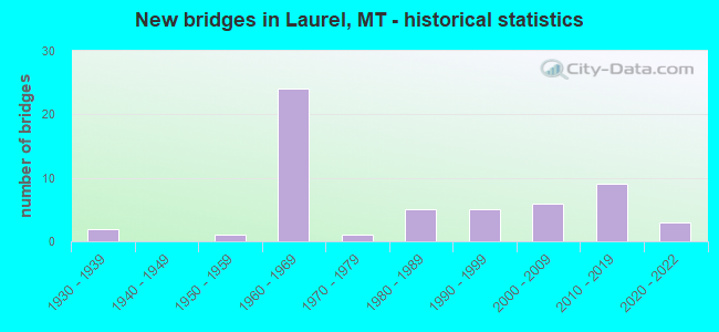
- New bridges - historical statistics
- 21930-1939
- 11950-1959
- 241960-1969
- 11970-1979
- 51980-1989
- 51990-1999
- 62000-2009
- 92010-2019
- 32020-2022
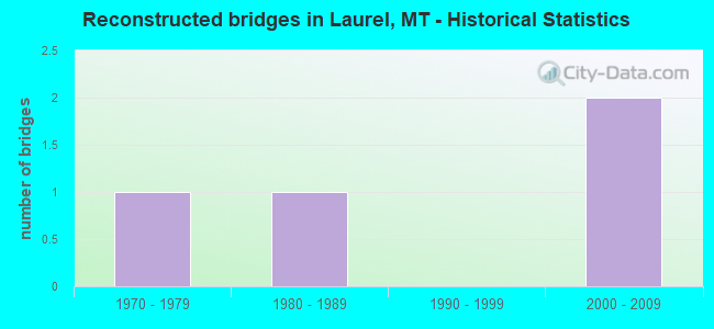
- Reconstructed bridges - Historical Statistics
- 11970-1979
- 11980-1989
- 01990-1999
- 22000-2009
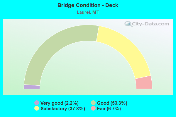
- Bridge Condition - Deck
- 2.2%Very good
- 53.3%Good
- 37.8%Satisfactory
- 6.7%Fair
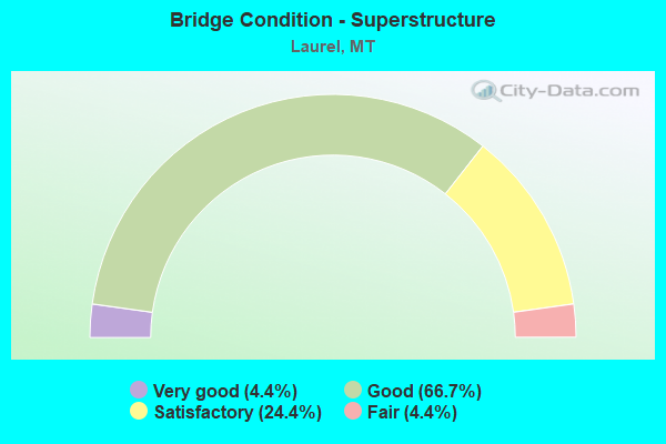
- Bridge Condition - Superstructure
- 4.4%Very good
- 66.7%Good
- 24.4%Satisfactory
- 4.4%Fair
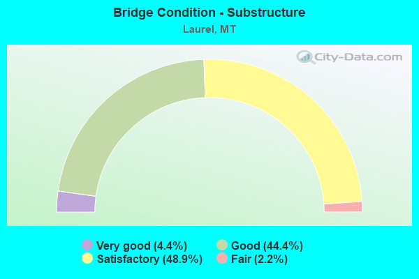
- Bridge Condition - Substructure
- 4.4%Very good
- 44.4%Good
- 48.9%Satisfactory
- 2.2%Fair
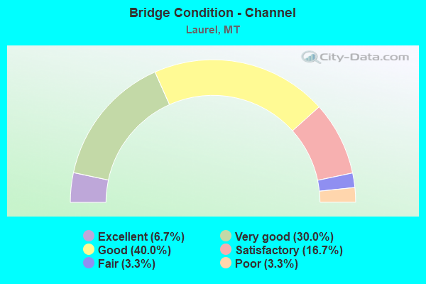
- Bridge Condition - Channel
- 6.7%Excellent
- 30.0%Very good
- 40.0%Good
- 16.7%Satisfactory
- 3.3%Fair
- 3.3%Poor
Find on map >> Show street view
Structure Number: 1741, Location: LAUREL (Lat: 45.663942, Lng: -108.789969), Route carried "on" structure: Interstate 90, Year Built: 2018, Status: Open, Structure Length: 16.95m (55.61ft), Average Daily Traffic: 13,672 (year 2020), Truck Traffic: 17%, Average Future Daily Traffic: 15,039 (year 2040), Design Load: HL 93, Features Intersected: INT W LAUREL-RR
Minimum Vertical Clearance: 30+ m (98+ ft), Kilometerpoint: 693.440, Lanes on structure: 2, Lanes under structure: 2, Base Highway Network: Yes, Owner: State Highway Agency, Approaching Roadway Width: 15.2m (49.9ft), Material/Design: Steel continuous, Design/Construction: Stringer/Multi-beam, Number Of Spans In Main Unit: 3, Length of Maximum Span: 66.4m (217.8ft), Curb-To-Curb Width: 15.1m (49.5ft), Out-to-Out Width: 15.8m (51.8ft)
Condition: Deck: Good, Superstructure: Good, Substructure: Good, Operating Rating: 48.1 metric tons, Method Used To Determine Operating Rating: Load and Resistance Factor (LRFR), Inventory Rating: 37.2 metric tons, Method Used To Determine Inventory Rating: Load and Resistance Factor (LRFR), Structural Evaluation: Better than present minimum criteria, Deck Geometry: Superior to present desirable criteria, Underclear: High priority of corrective action, Approach Roadway Alignment: Equal to present minimum criteria, Designated Inspection Frequency: Every 24 months, Inspection Date: November 2020, Deck Structure Type: Concrete Cast-file-Place
Find on map >> Show street view
Structure Number: 481, Location: 3M NE LAUREL (Lat: 45.697217, Lng: -108.709503), Route carried "on" structure: County highway 56507, Year Built: 2017, Status: Open, Structure Length: 3.11m (10.20ft), Average Daily Traffic: 751 (year 2020), Truck Traffic: 3%, Average Future Daily Traffic: 789 (year 2040), Features Intersected: RR 045, Facility Carried by Structure: LAUREL AIRPORT RD
Minimum Vertical Clearance: 30+ m (98+ ft), Kilometerpoint: 4.037, Lanes on structure: 2, Owner: County Highway Agency, Approaching Roadway Width: 10.2m (33.5ft), Material/Design: Prestressed concrete, Design/Construction: Tee Beam, Length of Maximum Span: 29.8m (97.8ft), Curb-To-Curb Width: 10.1m (33.1ft), Out-to-Out Width: 10.9m (35.8ft)
Condition: Deck: Good, Superstructure: Good, Substructure: Good, Operating Rating: 32.7 metric tons, Method Used To Determine Operating Rating: Load and Resistance Factor (LRFR), Inventory Rating: 20.9 metric tons, Method Used To Determine Inventory Rating: Load and Resistance Factor (LRFR), Structural Evaluation: Somewhat better than minimum adequacy, Deck Geometry: Equal to present minimum criteria, Underclear: Somewhat better than minimum adequacy, Approach Roadway Alignment: Equal to present desirable criteria, Length Of Structure Improvement: 3.11m (10.20ft), Designated Inspection Frequency: Every 24 months, Inspection Date: June 2021, Bridge Improvement Cost: $162,000, Roadway Improvement Cost: $81,000, Total Project Cost: $243,000, Deck Structure Type: Concrete Precast Panels, Wearing Surface/Protective System: Wearing Surface: Bituminous, Membrane: Preformed Fabric, Deck Protection: Epoxy Coated Reinforcing
Find on map >> Show street view
Structure Number: 4999, Location: NW LAUREL-W BEARTOOTH DR (Lat: 45.684144, Lng: -108.780997), Route carried "on" structure: City street 56069, Year Built: 2018, Status: Open, Structure Length: 1.40m (4.59ft), Average Daily Traffic: 100 (year 2022), Truck Traffic: 3%, Average Future Daily Traffic: 100 (year 2037), Design Load: HL 93, Features Intersected: BIG DITCH 161, Facility Carried by Structure: W BEARTOOTH DR
Minimum Vertical Clearance: 30+ m (98+ ft), Kilometerpoint: 0.176, Lanes on structure: 2, Owner: County Highway Agency, Approaching Roadway Width: 5.5m (18.0ft), Material/Design: Prestressed concrete, Design/Construction: Tee Beam, Number Of Spans In Main Unit: 1, Length of Maximum Span: 12.8m (42.0ft), Curb-To-Curb Width: 10.4m (34.1ft), Out-to-Out Width: 11.0m (36.1ft)
Condition: Deck: Good, Superstructure: Good, Substructure: Good, Channel: Good, Operating Rating: 46.3 metric tons, Method Used To Determine Operating Rating: Load and Resistance Factor (LRFR), Inventory Rating: 30.8 metric tons, Method Used To Determine Inventory Rating: Load and Resistance Factor (LRFR), Structural Evaluation: Better than present minimum criteria, Deck Geometry: Superior to present desirable criteria, Waterway Adequacy: Superior to present desirable criteria, Approach Roadway Alignment: Better than present minimum criteria, Designated Inspection Frequency: Every 24 months, Inspection Date: January 2021, Deck Structure Type: Concrete Precast Panels
Find on map >> Show street view
Structure Number: 7088, Location: 3M NE LAUREL (Lat: 45.694828, Lng: -108.732853), Route carried "on" structure: County highway 56125, Year Built: 2003, Status: Open, Structure Length: 1.05m (3.44ft), Average Daily Traffic: 100 (year 2022), Truck Traffic: 3%, Average Future Daily Traffic: 100 (year 2037), Design Load: HS 20, Features Intersected: BIG DITCH, Facility Carried by Structure: PHEASANT BROOK DRI
Minimum Vertical Clearance: 30+ m (98+ ft), Kilometerpoint: 0.337, Lanes on structure: 2, Owner: County Highway Agency, Approaching Roadway Width: 11.7m (38.4ft), Material/Design: Prestressed concrete, Design/Construction: Tee Beam, Number Of Spans In Main Unit: 1, Length of Maximum Span: 9.8m (32.2ft), Curb or Sidewalk Widths: Left: 0.0m, Right: 1.5m (4.9ft), Curb-To-Curb Width: 10.5m (34.4ft), Out-to-Out Width: 11.0m (36.1ft)
Condition: Deck: Satisfactory, Superstructure: Good, Substructure: Good, Channel: Very good, Operating Rating: 42.6 metric tons, Method Used To Determine Operating Rating: Load and Resistance Factor (LRFR), Inventory Rating: 29.9 metric tons, Method Used To Determine Inventory Rating: Load and Resistance Factor (LRFR), Structural Evaluation: Better than present minimum criteria, Deck Geometry: Superior to present desirable criteria, Waterway Adequacy: Equal to present desirable criteria, Approach Roadway Alignment: Equal to present minimum criteria, Designated Inspection Frequency: Every 24 months, Inspection Date: January 2021, Deck Structure Type: Concrete Precast Panels
Find on map >> Show street view
Structure Number: 7089, Location: 3M NE LAUREL (Lat: 45.691756, Lng: -108.737428), Route carried "on" structure: County highway 56125, Year Built: 2003, Status: Open, Structure Length: 1.17m (3.84ft), Average Daily Traffic: 100 (year 2022), Truck Traffic: 3%, Average Future Daily Traffic: 100 (year 2037), Design Load: HS 20, Features Intersected: BIG DITCH, Facility Carried by Structure: PHEASANT BROOK DR
Minimum Vertical Clearance: 30+ m (98+ ft), Kilometerpoint: 1.217, Lanes on structure: 2, Owner: County Highway Agency, Approaching Roadway Width: 11.7m (38.4ft), Material/Design: Prestressed concrete, Design/Construction: Tee Beam, Number Of Spans In Main Unit: 1, Length of Maximum Span: 10.9m (35.8ft), Curb or Sidewalk Widths: Left: 0.0m, Right: 1.5m (4.9ft), Curb-To-Curb Width: 11.0m (36.1ft), Out-to-Out Width: 11.0m (36.1ft)
Condition: Deck: Good, Superstructure: Good, Substructure: Good, Channel: Very good, Operating Rating: 40.8 metric tons, Method Used To Determine Operating Rating: Load and Resistance Factor (LRFR), Inventory Rating: 28.1 metric tons, Method Used To Determine Inventory Rating: Load and Resistance Factor (LRFR), Structural Evaluation: Better than present minimum criteria, Deck Geometry: Superior to present desirable criteria, Waterway Adequacy: Equal to present desirable criteria, Approach Roadway Alignment: Equal to present desirable criteria, Designated Inspection Frequency: Every 24 months, Inspection Date: January 2021, Deck Structure Type: Concrete Precast Panels
Find on map >> Show street view
Structure Number: 201901742, Location: LAUREL (Lat: 45.664039, Lng: -108.789628), Route carried "on" structure: Interstate 90, Year Built: 2019, Status: Open, Structure Length: 14.42m (47.31ft), Average Daily Traffic: 13,672 (year 2020), Truck Traffic: 17%, Average Future Daily Traffic: 15,039 (year 2040), Design Load: HL 93, Features Intersected: INT W LAUREL-RR
Minimum Vertical Clearance: 30+ m (98+ ft), Kilometerpoint: 693.651, Lanes on structure: 2, Lanes under structure: 4, Base Highway Network: Yes, Owner: State Highway Agency, Approaching Roadway Width: 13.1m (43.0ft), Material/Design: Steel continuous, Design/Construction: Stringer/Multi-beam, Number Of Spans In Main Unit: 3, Length of Maximum Span: 51.8m (169.9ft), Curb-To-Curb Width: 13.2m (43.3ft), Out-to-Out Width: 14.1m (46.3ft)
Condition: Deck: Good, Superstructure: Good, Substructure: Good, Operating Rating: 44.5 metric tons, Method Used To Determine Operating Rating: Load and Resistance Factor (LRFR), Inventory Rating: 34.5 metric tons, Method Used To Determine Inventory Rating: Load and Resistance Factor (LRFR), Structural Evaluation: Better than present minimum criteria, Deck Geometry: Superior to present desirable criteria, Underclear: High priority of corrective action, Approach Roadway Alignment: Equal to present minimum criteria, Designated Inspection Frequency: Every 24 months, Inspection Date: November 2021, Deck Structure Type: Concrete Cast-file-Place
Find on map >> Show street view
Structure Number: 202007006, Location: MISSOULA-RUSSELL STREET. (Lat: 46.876100, Lng: -114.018606), Route carried "on" structure: City street 129, Year Built: 2020, Status: Open, Structure Length: 14.13m (46.36ft), Average Daily Traffic: 15,747 (year 2020), Average Future Daily Traffic: 16,534 (year 2040), Design Load: HL 93, Features Intersected: CLARK FORK RIVER, Facility Carried by Structure: N RUSSEL STREET
Minimum Vertical Clearance: 3.48m (11.42ft), Kilometerpoint: 4.649, Lanes on structure: 5, Owner: State Highway Agency, Approaching Roadway Width: 15.8m (51.8ft), Skew: 20 degrees, Material/Design: Steel continuous, Design/Construction: Stringer/Multi-beam, Number Of Spans In Main Unit: 3, Length of Maximum Span: 53.3m (174.9ft), Curb or Sidewalk Widths: Left: 3.7m (12.1ft), Right: 3.7m (12.1ft), Curb-To-Curb Width: 15.5m (50.9ft), Out-to-Out Width: 28.7m (94.2ft)
Condition: Deck: Very good, Superstructure: Very good, Substructure: Very good, Channel: Excellent, Operating Rating: 50.8 metric tons, Method Used To Determine Operating Rating: Load and Resistance Factor (LRFR), Inventory Rating: 39.0 metric tons, Method Used To Determine Inventory Rating: Load and Resistance Factor (LRFR), Structural Evaluation: Equal to present desirable criteria, Deck Geometry: High priority of replacement, Waterway Adequacy: Equal to present desirable criteria, Approach Roadway Alignment: Better than present minimum criteria, Designated Inspection Frequency: Every 24 months, Inspection Date: July 2020, Deck Structure Type: Concrete Cast-file-Place, Wearing Surface/Protective System: Wearing Surface: Epoxy Overlay, Deck Protection: Other
Find on map >> Show street view
Structure Number: 202007026, Location: Laurel (Lat: 45.661867, Lng: -108.802517), Route carried "on" structure: County highway 56999, Year Built: 2020, Status: Open, Structure Length: 7.38m (24.21ft), Average Daily Traffic: 100 (year 2022), Truck Traffic: 3%, Average Future Daily Traffic: 100 (year 2037), Design Load: HL 93, Features Intersected: I-90, Facility Carried by Structure: 19th Ave W
Minimum Vertical Clearance: 30+ m (98+ ft), Kilometerpoint: 0.173, Lanes on structure: 2, Lanes under structure: 4, Owner: State Highway Agency, Approaching Roadway Width: 17.1m (56.1ft), Material/Design: Prestressed concrete, Design/Construction: Stringer/Multi-beam, Number Of Spans In Main Unit: 2, Length of Maximum Span: 36.9m (121.1ft), Curb-To-Curb Width: 16.3m (53.5ft), Out-to-Out Width: 17.1m (56.1ft)
Condition: Deck: Good, Superstructure: Very good, Substructure: Very good, Operating Rating: 54.4 metric tons, Method Used To Determine Operating Rating: Load and Resistance Factor (LRFR), Inventory Rating: 29.0 metric tons, Method Used To Determine Inventory Rating: Load and Resistance Factor (LRFR), Structural Evaluation: Better than present minimum criteria, Deck Geometry: Superior to present desirable criteria, Underclear: High priority of corrective action, Approach Roadway Alignment: Equal to present minimum criteria, Designated Inspection Frequency: Every 24 months, Inspection Date: April 2020, Deck Structure Type: Concrete Cast-file-Place
Find on map >> Show street view
Structure Number: I00090431+03331, Location: 1.9M W LAUREL (Lat: 45.656803, Lng: -108.822536), Route carried "on" structure: Interstate 90, Year Built: 1967, Status: Open, Structure Length: 3.81m (12.50ft), Average Daily Traffic: 13,605 (year 2020), Truck Traffic: 17%, Average Future Daily Traffic: 14,966 (year 2040), Design Load: HS 20, Features Intersected: SEP WOLD ROAD
Minimum Vertical Clearance: 30+ m (98+ ft), Kilometerpoint: 690.742, Lanes on structure: 2, Lanes under structure: 2, Base Highway Network: Yes, Owner: State Highway Agency, Approaching Roadway Width: 11.6m (38.1ft), Skew: 1 degrees, Material/Design: Prestressed concrete, Design/Construction: Stringer/Multi-beam, Number Of Spans In Main Unit: 3, Length of Maximum Span: 12.8m (42.0ft), Curb-To-Curb Width: 11.3m (37.1ft), Out-to-Out Width: 12.3m (40.4ft)
Condition: Deck: Satisfactory, Superstructure: Good, Substructure: Satisfactory, Operating Rating: 44.5 metric tons, Method Used To Determine Operating Rating: Load and Resistance Factor (LRFR), Inventory Rating: 25.4 metric tons, Method Used To Determine Inventory Rating: Load and Resistance Factor (LRFR), Structural Evaluation: Equal to present minimum criteria, Deck Geometry: Somewhat better than minimum adequacy, Underclear: Meets minimum limits, Approach Roadway Alignment: Equal to present desirable criteria, Designated Inspection Frequency: Every 24 months, Inspection Date: September 2021, Deck Structure Type: Concrete Cast-file-Place, Wearing Surface/Protective System: Wearing Surface: Latex Concrete
Find on map >> Show street view
Structure Number: I00090431+03332, Location: 1.9M W LAUREL (Lat: 45.657042, Lng: -108.822514), Route carried "on" structure: Interstate 90, Year Built: 1967, Status: Open, Structure Length: 3.81m (12.50ft), Average Daily Traffic: 13,605 (year 2020), Truck Traffic: 17%, Average Future Daily Traffic: 14,966 (year 2040), Design Load: HS 20, Features Intersected: SEP WOLD ROAD
Minimum Vertical Clearance: 30+ m (98+ ft), Kilometerpoint: 690.924, Lanes on structure: 2, Lanes under structure: 2, Base Highway Network: Yes, Owner: State Highway Agency, Approaching Roadway Width: 11.6m (38.1ft), Skew: 1 degrees, Material/Design: Prestressed concrete, Design/Construction: Stringer/Multi-beam, Number Of Spans In Main Unit: 3, Length of Maximum Span: 12.8m (42.0ft), Curb-To-Curb Width: 11.3m (37.1ft), Out-to-Out Width: 12.3m (40.4ft)
Condition: Deck: Satisfactory, Superstructure: Good, Substructure: Satisfactory, Operating Rating: 44.5 metric tons, Method Used To Determine Operating Rating: Load and Resistance Factor (LRFR), Inventory Rating: 25.4 metric tons, Method Used To Determine Inventory Rating: Load and Resistance Factor (LRFR), Structural Evaluation: Equal to present minimum criteria, Deck Geometry: Somewhat better than minimum adequacy, Underclear: Meets minimum limits, Approach Roadway Alignment: Equal to present desirable criteria, Designated Inspection Frequency: Every 24 months, Inspection Date: September 2021, Deck Structure Type: Concrete Cast-file-Place, Wearing Surface/Protective System: Wearing Surface: Latex Concrete
Find on map >> Show street view
Structure Number: I00090434+00901, Location: LAUREL (Lat: 45.662467, Lng: -108.769667), Route carried "on" structure: Interstate 90, Year Built: 1964, Year Reconstructed: 2007, Status: Open, Structure Length: 11.15m (36.58ft), Average Daily Traffic: 13,672 (year 2020), Truck Traffic: 17%, Average Future Daily Traffic: 15,039 (year 2040), Design Load: HS 20, Features Intersected: INT LAUREL-P 4-RR
Minimum Vertical Clearance: 30+ m (98+ ft), Kilometerpoint: 695.167, Lanes on structure: 2, Lanes under structure: 4, Base Highway Network: Yes, Owner: State Highway Agency, Approaching Roadway Width: 12.0m (39.4ft), Skew: 1 degrees, Material/Design: Steel, Design/Construction: Stringer/Multi-beam, Number Of Spans In Main Unit: 2, Number Of Approach Spans: 3, Length of Maximum Span: 34.1m (111.9ft), Curb-To-Curb Width: 11.2m (36.7ft), Out-to-Out Width: 12.0m (39.4ft)
Condition: Deck: Satisfactory, Superstructure: Satisfactory, Substructure: Satisfactory, Operating Rating: 34.5 metric tons, Method Used To Determine Operating Rating: Load and Resistance Factor (LRFR), Inventory Rating: 27.2 metric tons, Method Used To Determine Inventory Rating: Load and Resistance Factor (LRFR), Structural Evaluation: Equal to present minimum criteria, Deck Geometry: Somewhat better than minimum adequacy, Underclear: High priority of corrective action, Approach Roadway Alignment: Equal to present desirable criteria, Length Of Structure Improvement: 12.00m (39.37ft), Designated Inspection Frequency: Every 24 months, Inspection Date: June 2021, Bridge Improvement Cost: $692,000, Roadway Improvement Cost: $69,000, Total Project Cost: $761,000, Deck Structure Type: Concrete Cast-file-Place, Wearing Surface/Protective System: Wearing Surface: Monolithic Concrete
Find on map >> Show street view
Structure Number: I00090434+00902, Location: LAUREL (Lat: 45.662650, Lng: -108.769928), Route carried "on" structure: Interstate 90, Year Built: 1964, Year Reconstructed: 2007, Status: Open, Structure Length: 11.15m (36.58ft), Average Daily Traffic: 22,704 (year 2020), Truck Traffic: 12%, Average Future Daily Traffic: 24,974 (year 2040), Design Load: HS 20, Features Intersected: INT LAUREL-P 4-RR
Minimum Vertical Clearance: 30+ m (98+ ft), Kilometerpoint: 695.326, Lanes on structure: 2, Lanes under structure: 4, Base Highway Network: Yes, Owner: State Highway Agency, Approaching Roadway Width: 11.6m (38.1ft), Skew: 1 degrees, Material/Design: Steel, Design/Construction: Stringer/Multi-beam, Number Of Spans In Main Unit: 2, Number Of Approach Spans: 3, Length of Maximum Span: 34.1m (111.9ft), Curb or Sidewalk Widths: Left: 0.1m (0.3ft), Right: 0.1m (0.3ft), Curb-To-Curb Width: 12.2m (40.0ft), Out-to-Out Width: 13.4m (44.0ft)
Condition: Deck: Satisfactory, Superstructure: Satisfactory, Substructure: Satisfactory, Operating Rating: 46.3 metric tons, Method Used To Determine Operating Rating: Load and Resistance Factor (LRFR), Inventory Rating: 31.8 metric tons, Method Used To Determine Inventory Rating: Load and Resistance Factor (LRFR), Structural Evaluation: Equal to present minimum criteria, Deck Geometry: Better than present minimum criteria, Underclear: High priority of corrective action, Approach Roadway Alignment: Equal to present desirable criteria, Designated Inspection Frequency: Every 24 months, Inspection Date: June 2021, Deck Structure Type: Concrete Cast-file-Place, Wearing Surface/Protective System: Wearing Surface: Monolithic Concrete
Find on map >> Show street view
Structure Number: I00090437+04791, Location: 3.1M E LAUREL (Lat: 45.683011, Lng: -108.705878), Route carried "on" structure: Interstate 90, Year Built: 1964, Status: Open, Structure Length: 3.66m (12.01ft), Average Daily Traffic: 26,045 (year 2020), Truck Traffic: 10%, Average Future Daily Traffic: 29,431 (year 2040), Design Load: HS 20, Features Intersected: INT MOSSMAIN ROAD-P 4
Minimum Vertical Clearance: 30+ m (98+ ft), Kilometerpoint: 700.653, Lanes on structure: 2, Lanes under structure: 2, Base Highway Network: Yes, Owner: State Highway Agency, Approaching Roadway Width: 11.6m (38.1ft), Material/Design: Prestressed concrete, Design/Construction: Stringer/Multi-beam, Number Of Spans In Main Unit: 3, Length of Maximum Span: 14.3m (46.9ft), Curb-To-Curb Width: 11.6m (38.1ft), Out-to-Out Width: 12.5m (41.0ft)
Condition: Deck: Satisfactory, Superstructure: Satisfactory, Substructure: Satisfactory, Operating Rating: 60.8 metric tons, Method Used To Determine Operating Rating: Load and Resistance Factor (LRFR), Inventory Rating: 41.7 metric tons, Method Used To Determine Inventory Rating: Load and Resistance Factor (LRFR), Structural Evaluation: Equal to present minimum criteria, Deck Geometry: Equal to present minimum criteria, Underclear: Meets minimum limits, Approach Roadway Alignment: Equal to present desirable criteria, Designated Inspection Frequency: Every 24 months, Inspection Date: October 2021, Deck Structure Type: Concrete Cast-file-Place, Wearing Surface/Protective System: Wearing Surface: Monolithic Concrete
Find on map >> Show street view
Structure Number: I00090437+04792, Location: 3.1M E LAUREL (Lat: 45.683231, Lng: -108.705994), Route carried "on" structure: Interstate 90, Year Built: 1964, Status: Open, Structure Length: 3.66m (12.01ft), Average Daily Traffic: 26,045 (year 2020), Truck Traffic: 10%, Average Future Daily Traffic: 29,431 (year 2040), Design Load: HS 20, Features Intersected: INT MOSSMAIN ROAD-P 4
Minimum Vertical Clearance: 30+ m (98+ ft), Kilometerpoint: 700.822, Lanes on structure: 2, Lanes under structure: 2, Base Highway Network: Yes, Owner: State Highway Agency, Approaching Roadway Width: 11.6m (38.1ft), Material/Design: Prestressed concrete, Design/Construction: Stringer/Multi-beam, Number Of Spans In Main Unit: 3, Length of Maximum Span: 14.3m (46.9ft), Curb-To-Curb Width: 11.6m (38.1ft), Out-to-Out Width: 12.5m (41.0ft)
Condition: Deck: Satisfactory, Superstructure: Fair, Substructure: Satisfactory, Operating Rating: 60.8 metric tons, Method Used To Determine Operating Rating: Load and Resistance Factor (LRFR), Inventory Rating: 41.7 metric tons, Method Used To Determine Inventory Rating: Load and Resistance Factor (LRFR), Structural Evaluation: Somewhat better than minimum adequacy, Deck Geometry: Equal to present minimum criteria, Underclear: Meets minimum limits, Approach Roadway Alignment: Equal to present desirable criteria, Designated Inspection Frequency: Every 24 months, Inspection Date: October 2021, Deck Structure Type: Concrete Cast-file-Place, Wearing Surface/Protective System: Wearing Surface: Epoxy Overlay
Find on map >> Show street view
Structure Number: I00090438+00391, Location: 3.7M E LAUREL (Lat: 45.686842, Lng: -108.695900), Route carried "on" structure: Interstate 90, Year Built: 1964, Status: Open, Structure Length: 1.25m (4.10ft), Average Daily Traffic: 26,045 (year 2020), Truck Traffic: 10%, Average Future Daily Traffic: 29,431 (year 2040), Design Load: HS 20, Features Intersected: BBWA CANAL
Minimum Vertical Clearance: 30+ m (98+ ft), Kilometerpoint: 701.541, Lanes on structure: 2, Base Highway Network: Yes, Owner: State Highway Agency, Approaching Roadway Width: 11.6m (38.1ft), Skew: 3 degrees, Material/Design: Prestressed concrete, Design/Construction: Stringer/Multi-beam, Number Of Spans In Main Unit: 1, Length of Maximum Span: 12.2m (40.0ft), Curb-To-Curb Width: 11.6m (38.1ft), Out-to-Out Width: 12.6m (41.3ft)
Condition: Deck: Good, Superstructure: Good, Substructure: Satisfactory, Channel: Good, Operating Rating: 50.8 metric tons, Method Used To Determine Operating Rating: Load and Resistance Factor (LRFR), Inventory Rating: 38.1 metric tons, Method Used To Determine Inventory Rating: Load and Resistance Factor (LRFR), Structural Evaluation: Equal to present minimum criteria, Deck Geometry: Equal to present minimum criteria, Waterway Adequacy: Superior to present desirable criteria, Approach Roadway Alignment: Equal to present desirable criteria, Designated Inspection Frequency: Every 24 months, Inspection Date: October 2021, Deck Structure Type: Concrete Cast-file-Place, Wearing Surface/Protective System: Wearing Surface: Bituminous
Find on map >> Show street view
Structure Number: I00090438+00392, Location: 3.7M E LAUREL (Lat: 45.687092, Lng: -108.695908), Route carried "on" structure: Interstate 90, Year Built: 1964, Status: Open, Structure Length: 1.25m (4.10ft), Average Daily Traffic: 26,045 (year 2020), Truck Traffic: 10%, Average Future Daily Traffic: 29,431 (year 2040), Design Load: HS 20, Features Intersected: BBWA CANAL
Minimum Vertical Clearance: 30+ m (98+ ft), Kilometerpoint: 701.720, Lanes on structure: 2, Base Highway Network: Yes, Owner: State Highway Agency, Approaching Roadway Width: 11.6m (38.1ft), Skew: 5 degrees, Material/Design: Prestressed concrete, Design/Construction: Stringer/Multi-beam, Number Of Spans In Main Unit: 1, Length of Maximum Span: 12.2m (40.0ft), Curb-To-Curb Width: 11.6m (38.1ft), Out-to-Out Width: 12.6m (41.3ft)
Condition: Deck: Good, Superstructure: Good, Substructure: Satisfactory, Channel: Very good, Operating Rating: 50.8 metric tons, Method Used To Determine Operating Rating: Load and Resistance Factor (LRFR), Inventory Rating: 38.1 metric tons, Method Used To Determine Inventory Rating: Load and Resistance Factor (LRFR), Structural Evaluation: Equal to present minimum criteria, Deck Geometry: Equal to present minimum criteria, Waterway Adequacy: Superior to present desirable criteria, Approach Roadway Alignment: Equal to present desirable criteria, Designated Inspection Frequency: Every 24 months, Inspection Date: October 2021, Deck Structure Type: Concrete Cast-file-Place, Wearing Surface/Protective System: Wearing Surface: Bituminous
Find on map >> Show street view
Structure Number: L56303000+08001, Location: 3M S LAUREL (Lat: 45.624833, Lng: -108.764928), Route carried "on" structure: County highway 56303, Year Built: 1997, Status: Open, Structure Length: 12.52m (41.08ft), Average Daily Traffic: 100 (year 2022), Truck Traffic: 3%, Average Future Daily Traffic: 100 (year 2037), Design Load: HS 20, Features Intersected: CLARKS FK YELLOWSTONE024, Facility Carried by Structure: BYAM RD
Minimum Vertical Clearance: 4.00m (13.12ft), Kilometerpoint: 11.353, Lanes on structure: 2, Owner: County Highway Agency, Approaching Roadway Width: 7.3m (24.0ft), Skew: 2 degrees, Material/Design: Prestressed concrete, Design/Construction: Stringer/Multi-beam, Number Of Spans In Main Unit: 3, Length of Maximum Span: 41.6m (136.5ft), Curb-To-Curb Width: 7.3m (24.0ft), Out-to-Out Width: 8.0m (26.2ft)
Condition: Deck: Satisfactory, Superstructure: Good, Substructure: Satisfactory, Channel: Satisfactory, Operating Rating: 32.7 metric tons, Method Used To Determine Operating Rating: Assigned rating based on Load Factor Design (LFD) reported in metric tons, Inventory Rating: 32.7 metric tons, Method Used To Determine Inventory Rating: Assigned rating based on Load Factor Design (LFD) reported in metric tons, Structural Evaluation: Equal to present minimum criteria, Deck Geometry: Equal to present minimum criteria, Waterway Adequacy: Superior to present desirable criteria, Approach Roadway Alignment: Equal to present desirable criteria, Designated Inspection Frequency: Every 24 months, Inspection Date: October 2020, Deck Structure Type: Concrete Cast-file-Place, Wearing Surface/Protective System: Wearing Surface: Monolithic Concrete
Find on map >> Show street view
Structure Number: L56304002+00001, Location: 3M SE LAUREL (Lat: 45.648264, Lng: -108.716733), Route carried "on" structure: County highway 56304, Year Built: 1969, Status: Open, Structure Length: 7.31m (23.98ft), Average Daily Traffic: 100 (year 2022), Truck Traffic: 3%, Average Future Daily Traffic: 100 (year 2037), Design Load: HS 20, Features Intersected: CLARKS FK YELLOWSTONE026, Facility Carried by Structure: THIEL RD
Minimum Vertical Clearance: 30+ m (98+ ft), Kilometerpoint: 3.150, Lanes on structure: 2, Owner: County Highway Agency, Approaching Roadway Width: 9.8m (32.2ft), Material/Design: Steel, Design/Construction: Stringer/Multi-beam, Number Of Spans In Main Unit: 2, Length of Maximum Span: 36.3m (119.1ft), Curb or Sidewalk Widths: Left: 0.3m (1.0ft), Right: 0.3m (1.0ft), Curb-To-Curb Width: 8.5m (27.9ft), Out-to-Out Width: 9.8m (32.2ft)
Condition: Deck: Fair, Superstructure: Good, Substructure: Good, Channel: Good, Operating Rating: 27.2 metric tons, Method Used To Determine Operating Rating: Load and Resistance Factor (LRFR), Inventory Rating: 20.9 metric tons, Method Used To Determine Inventory Rating: Load and Resistance Factor (LRFR), Structural Evaluation: Equal to present minimum criteria, Deck Geometry: Better than present minimum criteria, Waterway Adequacy: Superior to present desirable criteria, Approach Roadway Alignment: Meets minimum limits, Designated Inspection Frequency: Every 24 months, Underwater Inspection Frequency: Every 60 months, Inspection Date: August 2021, Underwater Inspection Date: August 2020, Deck Structure Type: Concrete Cast-file-Place, Wearing Surface/Protective System: Wearing Surface: Monolithic Concrete
Find on map >> Show street view
Structure Number: L56304002+03001, Location: 3M SE LAUREL (Lat: 45.647972, Lng: -108.715375), Route carried "on" structure: County highway 56304, Year Built: 1969, Status: Open, Structure Length: 1.04m (3.41ft), Average Daily Traffic: 100 (year 2022), Truck Traffic: 3%, Average Future Daily Traffic: 100 (year 2037), Features Intersected: SPRING CREEK 023, Facility Carried by Structure: RIVER RD
Minimum Vertical Clearance: 30+ m (98+ ft), Kilometerpoint: 3.254, Lanes on structure: 2, Owner: County Highway Agency, Approaching Roadway Width: 9.8m (32.2ft), Skew: 3 degrees, Material/Design: Prestressed concrete, Design/Construction: Channel Beam, Number Of Spans In Main Unit: 1, Length of Maximum Span: 9.8m (32.2ft), Curb-To-Curb Width: 9.0m (29.5ft), Out-to-Out Width: 9.1m (29.9ft)
Condition: Deck: Satisfactory, Superstructure: Fair, Substructure: Satisfactory, Channel: Good, Operating Rating: 40.8 metric tons, Method Used To Determine Operating Rating: Field evaluation and documented engineering judgment, Inventory Rating: 24.5 metric tons, Method Used To Determine Inventory Rating: Field evaluation and documented engineering judgment, Structural Evaluation: Somewhat better than minimum adequacy, Deck Geometry: Better than present minimum criteria, Waterway Adequacy: Superior to present desirable criteria, Approach Roadway Alignment: Equal to present minimum criteria, Designated Inspection Frequency: Every 24 months, Inspection Date: September 2020, Deck Structure Type: Concrete Cast-file-Place, Wearing Surface/Protective System: Wearing Surface: Bituminous
Find on map >> Show street view
Structure Number: L56367000+01001, Location: 3M NE LAUREL (Lat: 45.681750, Lng: -108.712306), Route carried "on" structure: County highway 6903, Year Built: 1984, Status: Open, Structure Length: 1.01m (3.31ft), Average Daily Traffic: 1,556 (year 2020), Truck Traffic: 3%, Average Future Daily Traffic: 1,828 (year 2040), Design Load: HS 20, Features Intersected: CANYON CREEK DITCH 061, Facility Carried by Structure: SHANNON RD
Minimum Vertical Clearance: 30+ m (98+ ft), Kilometerpoint: 5.125, Lanes on structure: 2, Owner: County Highway Agency, Approaching Roadway Width: 9.8m (32.2ft), Material/Design: Prestressed concrete, Design/Construction: Tee Beam, Number Of Spans In Main Unit: 1, Length of Maximum Span: 9.1m (29.9ft), Curb-To-Curb Width: 9.8m (32.2ft), Out-to-Out Width: 9.8m (32.2ft)
Condition: Deck: Satisfactory, Superstructure: Satisfactory, Substructure: Satisfactory, Channel: Fair, Operating Rating: 48.1 metric tons, Method Used To Determine Operating Rating: Load and Resistance Factor (LRFR), Inventory Rating: 31.8 metric tons, Method Used To Determine Inventory Rating: Load and Resistance Factor (LRFR), Structural Evaluation: Equal to present minimum criteria, Deck Geometry: Somewhat better than minimum adequacy, Waterway Adequacy: Better than present minimum criteria, Approach Roadway Alignment: Meets minimum limits, Designated Inspection Frequency: Every 24 months, Inspection Date: December 2020, Deck Structure Type: Concrete Precast Panels
Find on map >> Show street view
Structure Number: L56505004+01001, Location: 4M NE LAUREL (Lat: 45.726281, Lng: -108.713489), Route carried "on" structure: County highway 56505, Year Built: 1960, Status: Open, Structure Length: 0.85m (2.79ft), Average Daily Traffic: 1,593 (year 2020), Truck Traffic: 3%, Average Future Daily Traffic: 1,673 (year 2040), Design Load: HS 20, Features Intersected: BIG DITCH 038, Facility Carried by Structure: NEIBAUER RD
Minimum Vertical Clearance: 30+ m (98+ ft), Kilometerpoint: 7.385, Lanes on structure: 2, Owner: County Highway Agency, Approaching Roadway Width: 7.3m (24.0ft), Skew: 3 degrees, Material/Design: Steel, Design/Construction: Stringer/Multi-beam, Number Of Spans In Main Unit: 1, Length of Maximum Span: 8.1m (26.6ft), Curb-To-Curb Width: 8.6m (28.2ft), Out-to-Out Width: 8.8m (28.9ft)
Condition: Deck: Satisfactory, Superstructure: Satisfactory, Substructure: Satisfactory, Channel: Satisfactory, Operating Rating: 55.3 metric tons, Method Used To Determine Operating Rating: Load Factor (LF), Inventory Rating: 33.6 metric tons, Method Used To Determine Inventory Rating: Load Factor (LF), Structural Evaluation: Equal to present minimum criteria, Deck Geometry: Somewhat better than minimum adequacy, Waterway Adequacy: Superior to present desirable criteria, Approach Roadway Alignment: Equal to present desirable criteria, Designated Inspection Frequency: Every 24 months, Inspection Date: December 2020, Deck Structure Type: Concrete Cast-file-Place, Wearing Surface/Protective System: Wearing Surface: Bituminous
Find on map >> Show street view
Structure Number: L56507008+04001, Location: 3M NE LAUREL (Lat: 45.697297, Lng: -108.730278), Route carried "on" structure: County highway 56507, Year Built: 1950, Status: Open, Structure Length: 1.49m (4.89ft), Average Daily Traffic: 751 (year 2020), Truck Traffic: 3%, Average Future Daily Traffic: 789 (year 2040), Design Load: HS 20, Features Intersected: BIG DITCH 044, Facility Carried by Structure: LAUREL AIRPORT RD
Minimum Vertical Clearance: 30+ m (98+ ft), Kilometerpoint: 2.419, Lanes on structure: 2, Owner: County Highway Agency, Approaching Roadway Width: 7.3m (24.0ft), Skew: 2 degrees, Material/Design: Prestressed concrete, Design/Construction: Tee Beam, Number Of Spans In Main Unit: 1, Length of Maximum Span: 7.0m (23.0ft), Curb-To-Curb Width: 7.9m (25.9ft), Out-to-Out Width: 7.9m (25.9ft)
Condition: Deck: Good, Superstructure: Good, Substructure: Satisfactory, Channel: Satisfactory, Operating Rating: 31.7 metric tons, Method Used To Determine Operating Rating: Allowable Stress (AS), Inventory Rating: 20.8 metric tons, Method Used To Determine Inventory Rating: Allowable Stress (AS), Structural Evaluation: Somewhat better than minimum adequacy, Deck Geometry: Somewhat better than minimum adequacy, Waterway Adequacy: Equal to present desirable criteria, Approach Roadway Alignment: Equal to present desirable criteria, Designated Inspection Frequency: Every 24 months, Inspection Date: November 2021, Deck Structure Type: Concrete Precast Panels, Wearing Surface/Protective System: Wearing Surface: Bituminous
Find on map >> Show street view
Structure Number: L56527003+01001, Location: SW BILLINGS (Lat: 45.711794, Lng: -108.720361), Route carried "on" structure: County highway 56527, Year Built: 1936, Year Reconstructed: 1981, Status: Posted for load, Structure Length: 0.94m (3.08ft), Average Daily Traffic: 100 (year 2022), Truck Traffic: 3%, Average Future Daily Traffic: 100 (year 2037), Features Intersected: BIG DITCH 109, Facility Carried by Structure: DANFORD RD
Minimum Vertical Clearance: 30+ m (98+ ft), Kilometerpoint: 4.798, Lanes on structure: 2, Owner: County Highway Agency, Approaching Roadway Width: 9.1m (29.9ft), Material/Design: Steel, Design/Construction: Stringer/Multi-beam, Number Of Spans In Main Unit: 1, Length of Maximum Span: 8.8m (28.9ft), Curb-To-Curb Width: 10.7m (35.1ft), Out-to-Out Width: 10.9m (35.8ft)
Condition: Deck: Good, Superstructure: Satisfactory, Substructure: Fair, Channel: Good, Operating Rating: 32.7 metric tons, Method Used To Determine Operating Rating: Load Factor (LF), Inventory Rating: 19.1 metric tons, Method Used To Determine Inventory Rating: Load Factor (LF), Structural Evaluation: Somewhat better than minimum adequacy, Deck Geometry: Superior to present desirable criteria, Waterway Adequacy: Superior to present desirable criteria, Approach Roadway Alignment: Equal to present desirable criteria, Bridge Posting: Required (Relationship of Operating Rating to Maximum Legal Load: 10.0 - 19.9% below), Designated Inspection Frequency: Every 24 months, Inspection Date: December 2020, Deck Structure Type: Concrete Cast-file-Place, Wearing Surface/Protective System: Wearing Surface: Bituminous
Find on map >> Show street view
Structure Number: L56546001+02001, Location: 4M W LAUREL (Lat: 45.674203, Lng: -108.843081), Route carried "on" structure: County highway 56546, Year Built: 1994, Status: Open, Structure Length: 1.62m (5.31ft), Average Daily Traffic: 100 (year 2022), Truck Traffic: 3%, Average Future Daily Traffic: 100 (year 2037), Design Load: HS 20, Features Intersected: BIG DITCH 065, Facility Carried by Structure: N HART RD
Minimum Vertical Clearance: 30+ m (98+ ft), Kilometerpoint: 2.430, Lanes on structure: 2, Owner: County Highway Agency, Approaching Roadway Width: 7.3m (24.0ft), Skew: 1 degrees, Material/Design: Prestressed concrete, Design/Construction: Tee Beam, Number Of Spans In Main Unit: 1, Length of Maximum Span: 15.2m (49.9ft), Curb-To-Curb Width: 6.7m (22.0ft), Out-to-Out Width: 7.4m (24.3ft)
Condition: Deck: Good, Superstructure: Good, Substructure: Good, Channel: Very good, Operating Rating: 32.7 metric tons, Method Used To Determine Operating Rating: Assigned rating based on Load Factor Design (LFD) reported in metric tons, Inventory Rating: 32.7 metric tons, Method Used To Determine Inventory Rating: Assigned rating based on Load Factor Design (LFD) reported in metric tons, Structural Evaluation: Better than present minimum criteria, Deck Geometry: Somewhat better than minimum adequacy, Waterway Adequacy: Superior to present desirable criteria, Approach Roadway Alignment: Equal to present desirable criteria, Designated Inspection Frequency: Every 24 months, Inspection Date: November 2020, Deck Structure Type: Concrete Precast Panels
Find on map >> Show street view
Structure Number: L56548002+09001, Location: 3M W LAUREL (Lat: 45.673206, Lng: -108.822539), Route carried "on" structure: County highway 56548, Year Built: 1988, Status: Open, Structure Length: 1.37m (4.49ft), Average Daily Traffic: 100 (year 2022), Truck Traffic: 3%, Average Future Daily Traffic: 100 (year 2037), Design Load: HS 20, Features Intersected: BIG DITCH 031, Facility Carried by Structure: 27TH AVE W
Minimum Vertical Clearance: 30+ m (98+ ft), Kilometerpoint: 4.559, Lanes on structure: 2, Owner: County Highway Agency, Approaching Roadway Width: 7.9m (25.9ft), Material/Design: Prestressed concrete, Design/Construction: Tee Beam, Number Of Spans In Main Unit: 1, Length of Maximum Span: 11.9m (39.0ft), Curb-To-Curb Width: 8.6m (28.2ft), Out-to-Out Width: 9.2m (30.2ft)
Condition: Deck: Good, Superstructure: Good, Substructure: Good, Channel: Satisfactory, Operating Rating: 32.7 metric tons, Method Used To Determine Operating Rating: Assigned rating based on Load Factor Design (LFD) reported in metric tons, Inventory Rating: 32.7 metric tons, Method Used To Determine Inventory Rating: Assigned rating based on Load Factor Design (LFD) reported in metric tons, Structural Evaluation: Better than present minimum criteria, Deck Geometry: Better than present minimum criteria, Waterway Adequacy: Somewhat better than minimum adequacy, Approach Roadway Alignment: Equal to present minimum criteria, Designated Inspection Frequency: Every 24 months, Inspection Date: November 2020, Deck Structure Type: Concrete Precast Panels
Find on map >> Show street view
Structure Number: L56558000+04001, Location: 3M E LAUREL (Lat: 45.678353, Lng: -108.699242), Route carried "on" structure: County highway 56558, Year Built: 2001, Status: Open, Structure Length: 2.50m (8.20ft), Average Daily Traffic: 100 (year 2022), Truck Traffic: 3%, Average Future Daily Traffic: 100 (year 2037), Design Load: HS 20, Features Intersected: BBWA CANAL 027, Facility Carried by Structure: ALLENDALE RD
Minimum Vertical Clearance: 30+ m (98+ ft), Kilometerpoint: 0.736, Lanes on structure: 2, Owner: County Highway Agency, Approaching Roadway Width: 6.4m (21.0ft), Skew: 2 degrees, Material/Design: Prestressed concrete, Design/Construction: Tee Beam, Number Of Spans In Main Unit: 1, Length of Maximum Span: 25.0m (82.0ft), Curb-To-Curb Width: 7.2m (23.6ft), Out-to-Out Width: 7.9m (25.9ft)
Condition: Deck: Good, Superstructure: Good, Substructure: Good, Channel: Good, Operating Rating: 54.4 metric tons, Method Used To Determine Operating Rating: Assigned rating based on Load Factor Design (LFD) reported in metric tons, Inventory Rating: 32.7 metric tons, Method Used To Determine Inventory Rating: Assigned rating based on Load Factor Design (LFD) reported in metric tons, Structural Evaluation: Better than present minimum criteria, Deck Geometry: Somewhat better than minimum adequacy, Waterway Adequacy: Superior to present desirable criteria, Approach Roadway Alignment: Equal to present desirable criteria, Designated Inspection Frequency: Every 24 months, Inspection Date: November 2020, Deck Structure Type: Concrete Precast Panels
Find on map >> Show street view
Structure Number: L56558001+03001, Location: 3M E LAUREL (Lat: 45.668222, Lng: -108.702272), Route carried "on" structure: County highway 56558, Year Built: 2002, Status: Open, Structure Length: 1.01m (3.31ft), Average Daily Traffic: 100 (year 2022), Truck Traffic: 3%, Average Future Daily Traffic: 100 (year 2037), Design Load: HS 20, Features Intersected: BBWA CANAL 028, Facility Carried by Structure: S LAUREL RD
Minimum Vertical Clearance: 30+ m (98+ ft), Kilometerpoint: 2.081, Lanes on structure: 2, Owner: County Highway Agency, Approaching Roadway Width: 8.5m (27.9ft), Skew: 1 degrees, Material/Design: Prestressed concrete, Design/Construction: Tee Beam, Number Of Spans In Main Unit: 1, Length of Maximum Span: 9.4m (30.8ft), Curb-To-Curb Width: 8.5m (27.9ft), Out-to-Out Width: 8.5m (27.9ft)
Condition: Deck: Good, Superstructure: Good, Substructure: Good, Channel: Excellent, Operating Rating: 32.7 metric tons, Method Used To Determine Operating Rating: Assigned rating based on Load Factor Design (LFD) reported in metric tons, Inventory Rating: 32.7 metric tons, Method Used To Determine Inventory Rating: Assigned rating based on Load Factor Design (LFD) reported in metric tons, Structural Evaluation: Better than present minimum criteria, Deck Geometry: Better than present minimum criteria, Waterway Adequacy: Equal to present desirable criteria, Approach Roadway Alignment: Equal to present desirable criteria, Designated Inspection Frequency: Every 24 months, Inspection Date: November 2020, Deck Structure Type: Concrete Precast Panels
Find on map >> Show street view
Structure Number: L56564000+02001, Location: LAKESIDE ESTATES (Lat: 45.744567, Lng: -108.733553), Route carried "on" structure: County highway 56564, Year Built: 1991, Status: Open, Structure Length: 0.82m (2.69ft), Average Daily Traffic: 100 (year 2022), Truck Traffic: 3%, Average Future Daily Traffic: 100 (year 2037), Design Load: HS 20, Features Intersected: COVE DITCH 015, Facility Carried by Structure: CUT THROAT DR
Minimum Vertical Clearance: 30+ m (98+ ft), Kilometerpoint: 0.244, Lanes on structure: 2, Owner: County Highway Agency, Approaching Roadway Width: 6.7m (22.0ft), Material/Design: Prestressed concrete, Design/Construction: Tee Beam, Number Of Spans In Main Unit: 1, Length of Maximum Span: 8.2m (26.9ft), Curb-To-Curb Width: 7.2m (23.6ft), Out-to-Out Width: 7.3m (24.0ft)
Condition: Deck: Satisfactory, Superstructure: Good, Substructure: Satisfactory, Channel: Poor, Operating Rating: 32.7 metric tons, Method Used To Determine Operating Rating: Assigned rating based on Load Factor Design (LFD) reported in metric tons, Inventory Rating: 32.7 metric tons, Method Used To Determine Inventory Rating: Assigned rating based on Load Factor Design (LFD) reported in metric tons, Structural Evaluation: Equal to present minimum criteria, Deck Geometry: Somewhat better than minimum adequacy, Waterway Adequacy: Superior to present desirable criteria, Approach Roadway Alignment: Better than present minimum criteria, Designated Inspection Frequency: Every 24 months, Inspection Date: November 2020, Deck Structure Type: Concrete Precast Panels
Find on map >> Show street view
Structure Number: L56564001+06001, Location: LAKESIDE ESTATES (Lat: 45.745436, Lng: -108.735358), Route carried "on" structure: County highway 56564, Year Built: 1991, Status: Open, Structure Length: 0.98m (3.22ft), Average Daily Traffic: 100 (year 2022), Truck Traffic: 3%, Average Future Daily Traffic: 100 (year 2037), Design Load: HS 20, Features Intersected: COVE DITCH 016, Facility Carried by Structure: LONGMEADOW DR
Minimum Vertical Clearance: 30+ m (98+ ft), Kilometerpoint: 0.454, Lanes on structure: 2, Owner: County Highway Agency, Approaching Roadway Width: 6.7m (22.0ft), Material/Design: Prestressed concrete, Design/Construction: Tee Beam, Number Of Spans In Main Unit: 1, Length of Maximum Span: 9.8m (32.2ft), Curb-To-Curb Width: 7.2m (23.6ft), Out-to-Out Width: 7.3m (24.0ft)
Condition: Deck: Satisfactory, Superstructure: Good, Substructure: Good, Channel: Good, Operating Rating: 32.7 metric tons, Method Used To Determine Operating Rating: Assigned rating based on Load Factor Design (LFD) reported in metric tons, Inventory Rating: 32.7 metric tons, Method Used To Determine Inventory Rating: Assigned rating based on Load Factor Design (LFD) reported in metric tons, Structural Evaluation: Better than present minimum criteria, Deck Geometry: Somewhat better than minimum adequacy, Waterway Adequacy: Superior to present desirable criteria, Approach Roadway Alignment: Better than present minimum criteria, Designated Inspection Frequency: Every 24 months, Inspection Date: November 2020, Deck Structure Type: Concrete Precast Panels
Find on map >> Show street view
Structure Number: L56682000+01901, Location: 1M E LAUREL (Lat: 45.670597, Lng: -108.740542), Route carried "on" structure: ServiceState highway 56682, Year Built: 1964, Status: Open, Structure Length: 7.53m (24.70ft), Average Daily Traffic: 100 (year 2022), Truck Traffic: 3%, Average Future Daily Traffic: 100 (year 2037), Design Load: HS 15, Features Intersected: SEP I 90 013, Facility Carried by Structure: STRAUCH RD
Minimum Vertical Clearance: 30+ m (98+ ft), Kilometerpoint: 0.301, Lanes on structure: 2, Lanes under structure: 4, Owner: County Highway Agency, Maintenance Responsibility: State Highway Agency, Approaching Roadway Width: 6.7m (22.0ft), Skew: 2 degrees, Material/Design: Prestressed concrete, Design/Construction: Stringer/Multi-beam, Number Of Spans In Main Unit: 4, Length of Maximum Span: 21.9m (71.9ft), Curb or Sidewalk Widths: Left: 0.3m (1.0ft), Right: 0.3m (1.0ft), Curb-To-Curb Width: 7.3m (24.0ft), Out-to-Out Width: 8.2m (26.9ft)
Condition: Deck: Fair, Superstructure: Satisfactory, Substructure: Satisfactory, Operating Rating: 48.1 metric tons, Method Used To Determine Operating Rating: Load and Resistance Factor (LRFR), Inventory Rating: 29.9 metric tons, Method Used To Determine Inventory Rating: Load and Resistance Factor (LRFR), Structural Evaluation: Equal to present minimum criteria, Deck Geometry: Equal to present minimum criteria, Underclear: Equal to present minimum criteria, Approach Roadway Alignment: Meets minimum limits, Designated Inspection Frequency: Every 24 months, Inspection Date: April 2020, Deck Structure Type: Concrete Cast-file-Place, Wearing Surface/Protective System: Wearing Surface: Monolithic Concrete
Find on map >> Show street view
Structure Number: L56683000+06001, Location: 2M E LAUREL (Lat: 45.686639, Lng: -108.695817), Route carried "on" structure: ServiceState highway 56683, Year Built: 1965, Status: Open, Structure Length: 1.25m (4.10ft), Average Daily Traffic: 3,230 (year 2020), Truck Traffic: 7%, Average Future Daily Traffic: 3,392 (year 2040), Design Load: HS 20, Features Intersected: BBWA CANAL 032, Facility Carried by Structure: FRONTAGE ROAD 683
Minimum Vertical Clearance: 30+ m (98+ ft), Kilometerpoint: 0.968, Lanes on structure: 2, Owner: State Highway Agency, Approaching Roadway Width: 9.4m (30.8ft), Skew: 4 degrees, Material/Design: Prestressed concrete, Design/Construction: Stringer/Multi-beam, Number Of Spans In Main Unit: 1, Length of Maximum Span: 12.2m (40.0ft), Curb or Sidewalk Widths: Left: 0.4m (1.3ft), Right: 0.4m (1.3ft), Curb-To-Curb Width: 8.5m (27.9ft), Out-to-Out Width: 9.4m (30.8ft)
Condition: Deck: Good, Superstructure: Good, Substructure: Good, Channel: Good, Operating Rating: 32.7 metric tons, Method Used To Determine Operating Rating: Assigned rating based on Load Factor Design (LFD) reported in metric tons, Inventory Rating: 32.7 metric tons, Method Used To Determine Inventory Rating: Assigned rating based on Load Factor Design (LFD) reported in metric tons, Structural Evaluation: Better than present minimum criteria, Deck Geometry: Meets minimum limits, Waterway Adequacy: Superior to present desirable criteria, Approach Roadway Alignment: Equal to present desirable criteria, Designated Inspection Frequency: Every 48 months, Inspection Date: January 2021, Deck Structure Type: Concrete Cast-file-Place, Wearing Surface/Protective System: Wearing Surface: Bituminous
Find on map >> Show street view
Structure Number: L56999000+00501, Location: LAUREL-S 8TH AVE (Lat: 45.660736, Lng: -108.781767), Route carried "on" structure: ServiceCounty highway 1158, Year Built: 1967, Status: Open, Structure Length: 7.15m (23.46ft), Average Daily Traffic: 100 (year 2022), Truck Traffic: 3%, Average Future Daily Traffic: 100 (year 2037), Design Load: HS 20, Features Intersected: SEP I 90 010, Facility Carried by Structure: S 8TH AVE
Minimum Vertical Clearance: 30+ m (98+ ft), Kilometerpoint: 0.514, Lanes on structure: 2, Lanes under structure: 4, Owner: State Highway Agency, Approaching Roadway Width: 8.5m (27.9ft), Skew: 2 degrees, Material/Design: Prestressed concrete, Design/Construction: Stringer/Multi-beam, Number Of Spans In Main Unit: 4, Length of Maximum Span: 21.9m (71.9ft), Curb or Sidewalk Widths: Left: 0.5m (1.6ft), Right: 0.5m (1.6ft), Curb-To-Curb Width: 8.5m (27.9ft), Out-to-Out Width: 10.3m (33.8ft)
Condition: Deck: Fair, Superstructure: Good, Substructure: Satisfactory, Operating Rating: 39.9 metric tons, Method Used To Determine Operating Rating: Load and Resistance Factor (LRFR), Inventory Rating: 27.2 metric tons, Method Used To Determine Inventory Rating: Load and Resistance Factor (LRFR), Structural Evaluation: Equal to present minimum criteria, Deck Geometry: Better than present minimum criteria, Underclear: High priority of corrective action, Approach Roadway Alignment: Equal to present minimum criteria, Designated Inspection Frequency: Every 24 months, Inspection Date: March 2021, Deck Structure Type: Concrete Cast-file-Place, Wearing Surface/Protective System: Wearing Surface: Monolithic Concrete
Find on map >> Show street view
Structure Number: M56069000+00101, Location: LAUREL-YARD OFFICE ROAD (Lat: 45.687067, Lng: -108.740594), Route carried "on" structure: City street 56069, Year Built: 1982, Status: Open, Structure Length: 0.98m (3.22ft), Average Daily Traffic: 100 (year 2022), Truck Traffic: 3%, Average Future Daily Traffic: 100 (year 2037), Features Intersected: BIG DITCH 110, Facility Carried by Structure: YARD OFFICE ROAD
Minimum Vertical Clearance: 30+ m (98+ ft), Kilometerpoint: 0.818, Lanes on structure: 2, Owner: County Highway Agency, Approaching Roadway Width: 7.9m (25.9ft), Material/Design: Prestressed concrete, Design/Construction: Tee Beam, Number Of Spans In Main Unit: 1, Length of Maximum Span: 9.8m (32.2ft), Curb-To-Curb Width: 8.4m (27.6ft), Out-to-Out Width: 8.5m (27.9ft)
Condition: Deck: Good, Superstructure: Satisfactory, Substructure: Satisfactory, Channel: Satisfactory, Operating Rating: 47.1 metric tons, Method Used To Determine Operating Rating: Load Factor (LF), Inventory Rating: 32.7 metric tons, Method Used To Determine Inventory Rating: Load Factor (LF), Structural Evaluation: Equal to present minimum criteria, Deck Geometry: Equal to present minimum criteria, Waterway Adequacy: Superior to present desirable criteria, Approach Roadway Alignment: Equal to present desirable criteria, Designated Inspection Frequency: Every 24 months, Inspection Date: January 2021, Deck Structure Type: Concrete Precast Panels, Wearing Surface/Protective System: Wearing Surface: Bituminous
Find on map >> Show street view
Structure Number: M56069000+00201, Location: LAUREL-VALLEY DR (Lat: 45.683150, Lng: -108.773006), Route carried "on" structure: City street 56069, Year Built: 2008, Status: Open, Structure Length: 1.37m (4.49ft), Average Daily Traffic: 1,979 (year 2020), Truck Traffic: 3%, Average Future Daily Traffic: 2,078 (year 2040), Features Intersected: BIG DITCH 111, Facility Carried by Structure: VALLEY DR
Minimum Vertical Clearance: 30+ m (98+ ft), Kilometerpoint: 0.036, Lanes on structure: 2, Owner: County Highway Agency, Approaching Roadway Width: 8.5m (27.9ft), Skew: 2 degrees, Material/Design: Prestressed concrete, Design/Construction: Tee Beam, Number Of Spans In Main Unit: 1, Length of Maximum Span: 13.7m (44.9ft), Curb or Sidewalk Widths: Left: 2.0m (6.6ft), Right: 2.0m (6.6ft), Curb-To-Curb Width: 8.5m (27.9ft), Out-to-Out Width: 12.5m (41.0ft)
Condition: Deck: Good, Superstructure: Good, Substructure: Good, Channel: Very good, Operating Rating: 66.4 metric tons, Method Used To Determine Operating Rating: Load Factor (LF), Inventory Rating: 37.6 metric tons, Method Used To Determine Inventory Rating: Load Factor (LF), Structural Evaluation: Better than present minimum criteria, Deck Geometry: Somewhat better than minimum adequacy, Waterway Adequacy: Superior to present desirable criteria, Approach Roadway Alignment: Equal to present minimum criteria, Length Of Structure Improvement: 1.70m (5.58ft), Designated Inspection Frequency: Every 24 months, Inspection Date: January 2021, Bridge Improvement Cost: $59,000, Roadway Improvement Cost: $6,000, Total Project Cost: $65,000, Deck Structure Type: Concrete Precast Panels
Find on map >> Show street view
Structure Number: M56069000+00301, Location: NW LAUREL-VALLEY DR (Lat: 45.687125, Lng: -108.774789), Route carried "on" structure: City street 56069, Year Built: 1970, Status: Open, Structure Length: 0.73m (2.40ft), Average Daily Traffic: 1,979 (year 2020), Truck Traffic: 3%, Average Future Daily Traffic: 2,078 (year 2040), Design Load: HS 20, Features Intersected: HIGH DITCH 112, Facility Carried by Structure: VALLEY DR
Minimum Vertical Clearance: 30+ m (98+ ft), Kilometerpoint: 0.500, Lanes on structure: 2, Owner: County Highway Agency, Approaching Roadway Width: 6.7m (22.0ft), Material/Design: Prestressed concrete, Design/Construction: Tee Beam, Number Of Spans In Main Unit: 1, Length of Maximum Span: 6.7m (22.0ft), Curb or Sidewalk Widths: Left: 0.2m (0.7ft), Right: 0.2m (0.7ft), Curb-To-Curb Width: 7.4m (24.3ft), Out-to-Out Width: 7.7m (25.3ft)
Condition: Deck: Good, Superstructure: Good, Substructure: Satisfactory, Channel: Good, Operating Rating: 32.7 metric tons, Method Used To Determine Operating Rating: Assigned rating based on Load Factor Design (LFD) reported in metric tons, Inventory Rating: 32.7 metric tons, Method Used To Determine Inventory Rating: Assigned rating based on Load Factor Design (LFD) reported in metric tons, Structural Evaluation: Equal to present minimum criteria, Deck Geometry: Meets minimum limits, Waterway Adequacy: Superior to present desirable criteria, Approach Roadway Alignment: Better than present minimum criteria, Designated Inspection Frequency: Every 24 months, Inspection Date: January 2021, Deck Structure Type: Concrete Precast Panels, Wearing Surface/Protective System: Wearing Surface: Bituminous
Find on map >> Show street view
Structure Number: M56069000+00601, Location: 2M W LAUREL (Lat: 45.677414, Lng: -108.802517), Route carried "on" structure: City street 56069, Year Built: 1968, Status: Open, Structure Length: 1.22m (4.00ft), Average Daily Traffic: 1,165 (year 2020), Truck Traffic: 3%, Average Future Daily Traffic: 1,223 (year 2040), Design Load: HS 20, Features Intersected: BIG DITCH 029, Facility Carried by Structure: GOLF COURSE RD
Minimum Vertical Clearance: 30+ m (98+ ft), Kilometerpoint: 1.009, Lanes on structure: 2, Owner: County Highway Agency, Approaching Roadway Width: 8.2m (26.9ft), Skew: 1 degrees, Material/Design: Steel, Design/Construction: Stringer/Multi-beam, Number Of Spans In Main Unit: 1, Length of Maximum Span: 11.9m (39.0ft), Curb-To-Curb Width: 9.5m (31.2ft), Out-to-Out Width: 9.7m (31.8ft)
Condition: Deck: Good, Superstructure: Satisfactory, Substructure: Satisfactory, Channel: Good, Operating Rating: 47.2 metric tons, Method Used To Determine Operating Rating: Load Factor (LF), Inventory Rating: 28.1 metric tons, Method Used To Determine Inventory Rating: Load Factor (LF), Structural Evaluation: Equal to present minimum criteria, Deck Geometry: Somewhat better than minimum adequacy, Waterway Adequacy: Equal to present desirable criteria, Approach Roadway Alignment: Better than present minimum criteria, Designated Inspection Frequency: Every 24 months, Inspection Date: January 2021, Deck Structure Type: Concrete Cast-file-Place, Wearing Surface/Protective System: Wearing Surface: Bituminous
Find on map >> Show street view
Structure Number: M56069000+00701, Location: LAUREL-BERNHARDT RD (Lat: 45.660944, Lng: -108.761075), Route carried "on" structure: City street 56069, Year Built: 1980, Status: Open, Structure Length: 1.07m (3.51ft), Average Daily Traffic: 111 (year 2020), Truck Traffic: 3%, Average Future Daily Traffic: 117 (year 2040), Design Load: HS 20, Features Intersected: DRAINAGE DITCH 191, Facility Carried by Structure: BERNHARDT RD
Minimum Vertical Clearance: 30+ m (98+ ft), Kilometerpoint: 0.570, Lanes on structure: 2, Owner: County Highway Agency, Approaching Roadway Width: 7.9m (25.9ft), Skew: 3 degrees, Material/Design: Prestressed concrete, Design/Construction: Tee Beam, Number Of Spans In Main Unit: 1, Length of Maximum Span: 10.1m (33.1ft), Curb-To-Curb Width: 8.4m (27.6ft), Out-to-Out Width: 8.5m (27.9ft)
Condition: Deck: Satisfactory, Superstructure: Satisfactory, Substructure: Satisfactory, Channel: Very good, Operating Rating: 32.7 metric tons, Method Used To Determine Operating Rating: Assigned rating based on Load Factor Design (LFD) reported in metric tons, Inventory Rating: 32.7 metric tons, Method Used To Determine Inventory Rating: Assigned rating based on Load Factor Design (LFD) reported in metric tons, Structural Evaluation: Equal to present minimum criteria, Deck Geometry: Somewhat better than minimum adequacy, Waterway Adequacy: Equal to present desirable criteria, Approach Roadway Alignment: Equal to present desirable criteria, Designated Inspection Frequency: Every 24 months, Inspection Date: January 2021, Deck Structure Type: Concrete Precast Panels, Wearing Surface/Protective System: Wearing Surface: Bituminous
Find on map >> Show street view
Structure Number: M56069000+00801, Location: 1M E LAUREL (Lat: 45.659369, Lng: -108.740575), Route carried "on" structure: City street 56069, Year Built: 2014, Status: Open, Structure Length: 1.99m (6.53ft), Average Daily Traffic: 100 (year 2022), Truck Traffic: 3%, Average Future Daily Traffic: 100 (year 2037), Design Load: HS 20, Features Intersected: BBWA CANAL 063, Facility Carried by Structure: STRAUCH RD
Minimum Vertical Clearance: 30+ m (98+ ft), Kilometerpoint: 1.548, Lanes on structure: 2, Owner: County Highway Agency, Approaching Roadway Width: 4.6m (15.1ft), Skew: 1 degrees, Material/Design: Prestressed concrete, Design/Construction: Tee Beam, Number Of Spans In Main Unit: 1, Length of Maximum Span: 18.8m (61.7ft), Curb-To-Curb Width: 7.4m (24.3ft), Out-to-Out Width: 8.0m (26.2ft)
Condition: Deck: Good, Superstructure: Good, Substructure: Good, Channel: Very good, Operating Rating: 62.1 metric tons, Method Used To Determine Operating Rating: Load Factor (LF), Inventory Rating: 31.8 metric tons, Method Used To Determine Inventory Rating: Load Factor (LF), Structural Evaluation: Better than present minimum criteria, Deck Geometry: Equal to present minimum criteria, Waterway Adequacy: Equal to present desirable criteria, Approach Roadway Alignment: Equal to present desirable criteria, Length Of Structure Improvement: 1.90m (6.23ft), Designated Inspection Frequency: Every 24 months, Inspection Date: March 2020, Bridge Improvement Cost: $42,000, Roadway Improvement Cost: $21,000, Total Project Cost: $63,000, Deck Structure Type: Concrete Precast Panels
Find on map >> Show street view
Structure Number: M56069000+00901, Location: LAUREL-HILLBROOKE AVE (Lat: 45.683483, Lng: -108.756219), Route carried "on" structure: City street 56069, Year Built: 2006, Status: Open, Structure Length: 1.04m (3.41ft), Average Daily Traffic: 100 (year 2022), Truck Traffic: 3%, Average Future Daily Traffic: 100 (year 2037), Design Load: HS 20, Features Intersected: BIG DITCH 198, Facility Carried by Structure: HILLBROOKE AVE
Minimum Vertical Clearance: 30+ m (98+ ft), Kilometerpoint: 0.169, Lanes on structure: 2, Owner: County Highway Agency, Approaching Roadway Width: 7.2m (23.6ft), Skew: 3 degrees, Material/Design: Prestressed concrete, Design/Construction: Tee Beam, Number Of Spans In Main Unit: 1, Length of Maximum Span: 9.8m (32.2ft), Curb-To-Curb Width: 8.4m (27.6ft), Out-to-Out Width: 9.1m (29.9ft)
Condition: Deck: Good, Superstructure: Good, Substructure: Good, Channel: Good, Operating Rating: 47.4 metric tons, Method Used To Determine Operating Rating: Load Factor (LF), Inventory Rating: 37.4 metric tons, Method Used To Determine Inventory Rating: Load Factor (LF), Structural Evaluation: Better than present minimum criteria, Deck Geometry: Equal to present minimum criteria, Waterway Adequacy: Equal to present desirable criteria, Approach Roadway Alignment: Equal to present minimum criteria, Designated Inspection Frequency: Every 24 months, Inspection Date: March 2020, Deck Structure Type: Concrete Precast Panels, Wearing Surface/Protective System: Wearing Surface: Monolithic Concrete
Find on map >> Show street view
Structure Number: P00004052+06201, Location: 1M S LAUREL (Lat: 45.641783, Lng: -108.760592), Route carried "on" structure: State highway 4, Year Built: 2014, Status: Open, Structure Length: 11.58m (37.99ft), Average Daily Traffic: 11,459 (year 2020), Truck Traffic: 5%, Average Future Daily Traffic: 12,376 (year 2040), Design Load: HL 93, Features Intersected: RR, Facility Carried by Structure: US 310
Minimum Vertical Clearance: 30+ m (98+ ft), Kilometerpoint: 86.176, Lanes on structure: 2, Owner: State Highway Agency, Approaching Roadway Width: 12.8m (42.0ft), Material/Design: Steel continuous, Design/Construction: Stringer/Multi-beam, Number Of Spans In Main Unit: 3, Length of Maximum Span: 42.2m (138.5ft), Curb-To-Curb Width: 12.6m (41.3ft), Out-to-Out Width: 13.4m (44.0ft)
Condition: Deck: Satisfactory, Superstructure: Good, Substructure: Good, Operating Rating: 54.4 metric tons, Method Used To Determine Operating Rating: Assigned ratings based on Load and Resistance Factor Design (LRFD) reported in metric tons, Inventory Rating: 32.7 metric tons, Method Used To Determine Inventory Rating: Assigned ratings based on Load and Resistance Factor Design (LRFD) reported in metric tons, Structural Evaluation: Better than present minimum criteria, Deck Geometry: Somewhat better than minimum adequacy, Underclear: Superior to present desirable criteria, Approach Roadway Alignment: Better than present minimum criteria, Designated Inspection Frequency: Every 24 months, Inspection Date: July 2021, Deck Structure Type: Concrete Cast-file-Place, Wearing Surface/Protective System: Wearing Surface: Monolithic Concrete, Deck Protection: Epoxy Coated Reinforcing
Find on map >> Show street view
Structure Number: P00004052+06202, Location: 1M S LAUREL (Lat: 45.642272, Lng: -108.760303), Route carried "on" structure: State highway 4, Year Built: 2015, Status: Open, Structure Length: 11.59m (38.02ft), Average Daily Traffic: 11,459 (year 2020), Truck Traffic: 5%, Average Future Daily Traffic: 12,376 (year 2040), Design Load: HL 93, Features Intersected: RR, Facility Carried by Structure: US 310
Minimum Vertical Clearance: 30+ m (98+ ft), Kilometerpoint: 86.230, Lanes on structure: 2, Owner: State Highway Agency, Approaching Roadway Width: 11.6m (38.1ft), Material/Design: Steel continuous, Design/Construction: Stringer/Multi-beam, Number Of Spans In Main Unit: 3, Length of Maximum Span: 48.9m (160.4ft), Curb-To-Curb Width: 11.4m (37.4ft), Out-to-Out Width: 13.4m (44.0ft)
Condition: Deck: Satisfactory, Superstructure: Good, Substructure: Good, Operating Rating: 32.7 metric tons, Method Used To Determine Operating Rating: Assigned ratings based on Load and Resistance Factor Design (LRFD) reported in metric tons, Inventory Rating: 32.7 metric tons, Method Used To Determine Inventory Rating: Assigned ratings based on Load and Resistance Factor Design (LRFD) reported in metric tons, Structural Evaluation: Better than present minimum criteria, Deck Geometry: Equal to present minimum criteria, Underclear: Better than present minimum criteria, Approach Roadway Alignment: Equal to present desirable criteria, Designated Inspection Frequency: Every 24 months, Inspection Date: July 2021, Deck Structure Type: Concrete Cast-file-Place, Wearing Surface/Protective System: Wearing Surface: Monolithic Concrete, Deck Protection: Epoxy Coated Reinforcing