Bridge Statistics for Laguna Niguel, California (CA)
Condition, Traffic, Stress, Structural Evaluation, Project Costs
- National Bridge Inventory (NBI) Statistics
- 60Number of bridges
- 1,089ft / 332mTotal length
- $3,672,000Total costs
- 1,286,510Total average daily traffic
- 61,423Total average daily truck traffic
- National Bridge Inventory (NBI) Registered Bridges for Laguna Niguel
- No street view available for this location
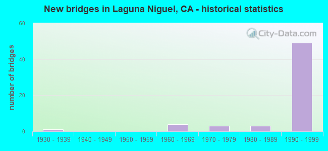
- New bridges - historical statistics
- 11930-1939
- 41960-1969
- 31970-1979
- 31980-1989
- 491990-1999

- Reconstructed bridges - Historical Statistics
- 11980-1989
- 01990-1999
- 22000-2009


- Bridge Condition - Deck
- 67.9%Good
- 28.6%Fair
- 3.6%Poor

- Bridge Condition - Superstructure
- 96.7%Good
- 3.3%Fair

- Bridge Condition - Substructure
- 96.7%Good
- 3.3%Fair

- Bridge Condition - Channel
- 10.0%Excellent
- 80.0%Very good
- 10.0%Good
Find on map >> Show street view
Structure Number: 55 071, Location: 12-ORA-241-24.67-IRVN (Lat: 33.693136, Lng: -117.688503), Route carried "on" structure: State highway 241, Year Built: 1993, Status: Open, Structure Length: 0.73m (2.40ft), Average Daily Traffic: 43,000 (year 2012), Truck Traffic: 3%, Average Future Daily Traffic: 93,800 (year 2040), Design Load: HS 20+Mod, Features Intersected: AQUA CHINON WASH
Minimum Vertical Clearance: 30+ m (98+ ft), Kilometerpoint: 24.670, Lanes on structure: 10, Base Highway Network: Yes (Inventory Route: 2, Subroute: 1), Toll: On toll road, Owner: State Highway Agency, Approaching Roadway Width: 23.8m (78.1ft), Skew: 12 degrees, Material/Design: Concrete, Design/Construction: Culvert, Number Of Spans In Main Unit: 2, Length of Maximum Span: 3.0m (9.8ft), Curb-To-Curb Width: 23.8m (78.1ft), Out-to-Out Width: 24.8m (81.4ft)
Condition: Channel: Very good, Culverts: Good, Operating Rating: 54.1 metric tons, Method Used To Determine Operating Rating: Field evaluation and documented engineering judgment, Inventory Rating: 32.4 metric tons, Method Used To Determine Inventory Rating: Field evaluation and documented engineering judgment, Structural Evaluation: Better than present minimum criteria, Deck Geometry: High priority of replacement, Waterway Adequacy: Equal to present desirable criteria, Approach Roadway Alignment: Equal to present desirable criteria, Designated Inspection Frequency: Every 48 months, Inspection Date: Febuary 2021
Find on map >> Show street view
Structure Number: 55 0719G, Location: 12-ORA-005-12.51-LGNG (Lat: 33.541100, Lng: -117.673428), Route carried "on" structure: Ramp Interstate 5, Year Built: 1996, Status: Open, Structure Length: 79.55m (260.99ft), Average Daily Traffic: 23,200 (year 2020), Truck Traffic: 4%, Average Future Daily Traffic: 27,185 (year 2043), Design Load: HS 20+Mod, Features Intersected: I 5; C. C.; METRO RAIL
Minimum Vertical Clearance: 6.44m (21.13ft), Kilometerpoint: 12.510, Lanes on structure: 3, Lanes under structure: 17, Base Highway Network: Yes (, Subroute: 1), Toll: On toll road, Owner: State Highway Agency, Approaching Roadway Width: 17.1m (56.1ft), Skew: 9 degrees, Material/Design: Prestressed concrete continuous, Design/Construction: Box Beam or Girders - Single/Spread, Number Of Spans In Main Unit: 12, Length of Maximum Span: 87.8m (288.1ft), Curb-To-Curb Width: 17.1m (56.1ft), Out-to-Out Width: 18.1m (59.4ft)
Condition: Deck: Good, Superstructure: Good, Substructure: Good, Channel: Very good, Operating Rating: 54.1 metric tons, Method Used To Determine Operating Rating: Assigned rating based on Load Factor Design (LFD) reported in metric tons, Inventory Rating: 32.4 metric tons, Method Used To Determine Inventory Rating: Assigned rating based on Load Factor Design (LFD) reported in metric tons, Structural Evaluation: Better than present minimum criteria, Deck Geometry: Superior to present desirable criteria, Underclear: Meets minimum limits, Waterway Adequacy: Equal to present desirable criteria, Approach Roadway Alignment: Equal to present desirable criteria, Designated Inspection Frequency: Every 24 months, Inspection Date: April 2021, Deck Structure Type: Concrete Cast-file-Place
Find on map >> Show street view
Structure Number: 55 0747R, Location: 12-ORA-073-11.31-LGNG (Lat: 33.555725, Lng: -117.678181), Route carried "on" structure: State highway 73, Year Built: 1996, Status: Open, Structure Length: 26.97m (88.48ft), Average Daily Traffic: 20,700 (year 2010), Truck Traffic: 1%, Average Future Daily Traffic: 25,900 (year 2040), Design Load: HS 20+Mod, Features Intersected: CROWN VALLEY PK,CABOT RD
Minimum Vertical Clearance: 30+ m (98+ ft), Kilometerpoint: 11.310, Lanes on structure: 3, Lanes under structure: 11, Base Highway Network: Yes (, Subroute: 1), Toll: On toll road, Owner: State Highway Agency, Approaching Roadway Width: 17.1m (56.1ft), Material/Design: Prestressed concrete continuous, Design/Construction: Box Beam or Girders - Multiple, Number Of Spans In Main Unit: 6, Length of Maximum Span: 57.6m (189.0ft), Curb-To-Curb Width: 17.1m (56.1ft), Out-to-Out Width: 18.1m (59.4ft)
Condition: Deck: Good, Superstructure: Good, Substructure: Good, Operating Rating: 54.1 metric tons, Method Used To Determine Operating Rating: Assigned rating based on Load Factor Design (LFD) reported in metric tons, Inventory Rating: 32.4 metric tons, Method Used To Determine Inventory Rating: Assigned rating based on Load Factor Design (LFD) reported in metric tons, Structural Evaluation: Better than present minimum criteria, Deck Geometry: Equal to present minimum criteria, Underclear: Meets minimum limits, Approach Roadway Alignment: Equal to present desirable criteria, Designated Inspection Frequency: Every 24 months, Inspection Date: June 2020, Deck Structure Type: Concrete Cast-file-Place
Find on map >> Show street view
Structure Number: 55 0748L, Location: 12-ORA-073-11.42-LGNG (Lat: 33.556481, Lng: -117.679842), Route carried "on" structure: State highway 73, Year Built: 1996, Status: Open, Structure Length: 13.78m (45.21ft), Average Daily Traffic: 25,000 (year 2010), Truck Traffic: 8%, Average Future Daily Traffic: 25,900 (year 2040), Design Load: HS 20+Mod, Features Intersected: CROWN VALLEY PARKWAY
Minimum Vertical Clearance: 30+ m (98+ ft), Kilometerpoint: 11.420, Lanes on structure: 3, Lanes under structure: 6, Base Highway Network: Yes (, Subroute: 1), Toll: On toll road, Owner: State Highway Agency, Approaching Roadway Width: 19.0m (62.3ft), Skew: 4 degrees, Material/Design: Prestressed concrete continuous, Design/Construction: Box Beam or Girders - Multiple, Number Of Spans In Main Unit: 3, Length of Maximum Span: 58.4m (191.6ft), Curb-To-Curb Width: 19.0m (62.3ft), Out-to-Out Width: 20.0m (65.6ft)
Condition: Deck: Good, Superstructure: Good, Substructure: Good, Operating Rating: 54.1 metric tons, Method Used To Determine Operating Rating: Assigned rating based on Load Factor Design (LFD) reported in metric tons, Inventory Rating: 32.4 metric tons, Method Used To Determine Inventory Rating: Assigned rating based on Load Factor Design (LFD) reported in metric tons, Structural Evaluation: Better than present minimum criteria, Deck Geometry: Superior to present desirable criteria, Underclear: High priority of corrective action, Approach Roadway Alignment: Equal to present desirable criteria, Designated Inspection Frequency: Every 24 months, Inspection Date: June 2020, Deck Structure Type: Concrete Cast-file-Place
Find on map >> Show street view
Structure Number: 55 0750L, Location: 12-ORA-073-12.91-LGNG (Lat: 33.568492, Lng: -117.699814), Route carried "on" structure: State highway 73, Year Built: 1996, Status: Open, Structure Length: 10.00m (32.81ft), Average Daily Traffic: 25,000 (year 2010), Truck Traffic: 8%, Average Future Daily Traffic: 25,900 (year 2040), Design Load: HS 20+Mod, Features Intersected: MOULTON PARKWAY
Minimum Vertical Clearance: 30+ m (98+ ft), Kilometerpoint: 12.910, Lanes on structure: 3, Lanes under structure: 6, Base Highway Network: Yes (, Subroute: 1), Toll: On toll road, Owner: State Highway Agency, Approaching Roadway Width: 17.1m (56.1ft), Skew: 2 degrees, Material/Design: Prestressed concrete continuous, Design/Construction: Box Beam or Girders - Multiple, Number Of Spans In Main Unit: 3, Length of Maximum Span: 54.3m (178.1ft), Curb-To-Curb Width: 17.1m (56.1ft), Out-to-Out Width: 18.1m (59.4ft)
Condition: Deck: Fair, Superstructure: Good, Substructure: Good, Operating Rating: 54.1 metric tons, Method Used To Determine Operating Rating: Assigned rating based on Load Factor Design (LFD) reported in metric tons, Inventory Rating: 32.4 metric tons, Method Used To Determine Inventory Rating: Assigned rating based on Load Factor Design (LFD) reported in metric tons, Structural Evaluation: Better than present minimum criteria, Deck Geometry: Equal to present minimum criteria, Underclear: High priority of corrective action, Approach Roadway Alignment: Equal to present desirable criteria, Designated Inspection Frequency: Every 24 months, Inspection Date: June 2020, Deck Structure Type: Concrete Cast-file-Place
Find on map >> Show street view
Structure Number: 55 0750R, Location: 12-ORA-073-12.91-LGNG (Lat: 33.568939, Lng: -117.699694), Route carried "on" structure: State highway 73, Year Built: 1996, Status: Open, Structure Length: 10.00m (32.81ft), Average Daily Traffic: 25,000 (year 2010), Truck Traffic: 8%, Average Future Daily Traffic: 25,900 (year 2040), Design Load: HS 20+Mod, Features Intersected: MOULTON PARKWAY
Minimum Vertical Clearance: 30+ m (98+ ft), Kilometerpoint: 12.910, Lanes on structure: 3, Lanes under structure: 6, Base Highway Network: Yes (, Subroute: 1), Toll: On toll road, Owner: State Highway Agency, Approaching Roadway Width: 17.1m (56.1ft), Skew: 2 degrees, Material/Design: Prestressed concrete continuous, Design/Construction: Box Beam or Girders - Multiple, Number Of Spans In Main Unit: 3, Length of Maximum Span: 54.3m (178.1ft), Curb-To-Curb Width: 17.1m (56.1ft), Out-to-Out Width: 18.1m (59.4ft)
Condition: Deck: Good, Superstructure: Good, Substructure: Good, Operating Rating: 54.1 metric tons, Method Used To Determine Operating Rating: Assigned rating based on Load Factor Design (LFD) reported in metric tons, Inventory Rating: 32.4 metric tons, Method Used To Determine Inventory Rating: Assigned rating based on Load Factor Design (LFD) reported in metric tons, Structural Evaluation: Better than present minimum criteria, Deck Geometry: Equal to present minimum criteria, Underclear: High priority of corrective action, Approach Roadway Alignment: Equal to present desirable criteria, Designated Inspection Frequency: Every 24 months, Inspection Date: June 2020, Deck Structure Type: Concrete Cast-file-Place
Find on map >> Show street view
Structure Number: 55 0750S, Location: 12-ORA-073-12.91-LGNG (Lat: 33.569103, Lng: -117.699564), Route carried "on" structure: Ramp State highway 73, Year Built: 1996, Status: Open, Structure Length: 12.65m (41.50ft), Average Daily Traffic: 1,190 (year 2010), Truck Traffic: 1%, Average Future Daily Traffic: 1,381 (year 2040), Design Load: HS 20+Mod, Features Intersected: MOULTON PARKWAY
Minimum Vertical Clearance: 30+ m (98+ ft), Kilometerpoint: 12.910, Lanes on structure: 1, Lanes under structure: 6, Base Highway Network: Yes, Toll: On toll road, Owner: State Highway Agency, Approaching Roadway Width: 7.4m (24.3ft), Material/Design: Prestressed concrete continuous, Design/Construction: Box Beam or Girders - Multiple, Number Of Spans In Main Unit: 3, Length of Maximum Span: 68.6m (225.1ft), Curb-To-Curb Width: 7.4m (24.3ft), Out-to-Out Width: 8.4m (27.6ft)
Condition: Deck: Good, Superstructure: Good, Substructure: Fair, Operating Rating: 54.1 metric tons, Method Used To Determine Operating Rating: Assigned rating based on Load Factor Design (LFD) reported in metric tons, Inventory Rating: 32.4 metric tons, Method Used To Determine Inventory Rating: Assigned rating based on Load Factor Design (LFD) reported in metric tons, Structural Evaluation: Somewhat better than minimum adequacy, Deck Geometry: Better than present minimum criteria, Underclear: High priority of corrective action, Approach Roadway Alignment: Equal to present desirable criteria, Designated Inspection Frequency: Every 24 months, Inspection Date: June 2020, Deck Structure Type: Concrete Cast-file-Place
Find on map >> Show street view
Structure Number: 55 0751K, Location: 12-ORA-073-13.16-LGNG (Lat: 33.570975, Lng: -117.703222), Route carried "on" structure: Ramp State highway 73, Year Built: 1996, Status: Open, Structure Length: 9.00m (29.53ft), Average Daily Traffic: 1,250 (year 2010), Truck Traffic: 1%, Average Future Daily Traffic: 1,445 (year 2040), Design Load: HS 20+Mod, Features Intersected: PACIFIC PARK DRIVE
Minimum Vertical Clearance: 30+ m (98+ ft), Kilometerpoint: 13.160, Lanes on structure: 2, Lanes under structure: 6, Base Highway Network: Yes, Toll: On toll road, Owner: State Highway Agency, Approaching Roadway Width: 12.0m (39.4ft), Skew: 2 degrees, Material/Design: Prestressed concrete continuous, Design/Construction: Box Beam or Girders - Multiple, Number Of Spans In Main Unit: 3, Length of Maximum Span: 48.8m (160.1ft), Curb-To-Curb Width: 12.0m (39.4ft), Out-to-Out Width: 13.0m (42.7ft)
Condition: Deck: Good, Superstructure: Good, Substructure: Good, Operating Rating: 54.1 metric tons, Method Used To Determine Operating Rating: Assigned rating based on Load Factor Design (LFD) reported in metric tons, Inventory Rating: 32.4 metric tons, Method Used To Determine Inventory Rating: Assigned rating based on Load Factor Design (LFD) reported in metric tons, Structural Evaluation: Better than present minimum criteria, Deck Geometry: Superior to present desirable criteria, Underclear: Meets minimum limits, Approach Roadway Alignment: Equal to present desirable criteria, Designated Inspection Frequency: Every 24 months, Inspection Date: June 2020, Deck Structure Type: Concrete Cast-file-Place
Find on map >> Show street view
Structure Number: 55 0751L, Location: 12-ORA-073-13.16-LGNG (Lat: 33.571075, Lng: -117.703025), Route carried "on" structure: State highway 73, Year Built: 1996, Status: Open, Structure Length: 9.02m (29.59ft), Average Daily Traffic: 25,000 (year 2010), Truck Traffic: 8%, Average Future Daily Traffic: 26,400 (year 2040), Design Load: HS 20+Mod, Features Intersected: PACIFIC PARK DRIVE
Minimum Vertical Clearance: 30+ m (98+ ft), Kilometerpoint: 13.160, Lanes on structure: 3, Lanes under structure: 6, Base Highway Network: Yes (, Subroute: 1), Toll: On toll road, Owner: State Highway Agency, Approaching Roadway Width: 17.1m (56.1ft), Skew: 2 degrees, Material/Design: Prestressed concrete continuous, Design/Construction: Box Beam or Girders - Multiple, Number Of Spans In Main Unit: 3, Length of Maximum Span: 48.8m (160.1ft), Curb-To-Curb Width: 17.1m (56.1ft), Out-to-Out Width: 18.1m (59.4ft)
Condition: Deck: Good, Superstructure: Good, Substructure: Good, Operating Rating: 54.1 metric tons, Method Used To Determine Operating Rating: Assigned rating based on Load Factor Design (LFD) reported in metric tons, Inventory Rating: 32.4 metric tons, Method Used To Determine Inventory Rating: Assigned rating based on Load Factor Design (LFD) reported in metric tons, Structural Evaluation: Better than present minimum criteria, Deck Geometry: Equal to present minimum criteria, Underclear: Meets minimum limits, Approach Roadway Alignment: Equal to present desirable criteria, Designated Inspection Frequency: Every 24 months, Inspection Date: June 2020, Deck Structure Type: Concrete Cast-file-Place
Find on map >> Show street view
Structure Number: 55 0751R, Location: 12-ORA-073-13.16-LGNG (Lat: 33.571258, Lng: -117.702536), Route carried "on" structure: State highway 73, Year Built: 1996, Status: Open, Structure Length: 9.02m (29.59ft), Average Daily Traffic: 25,000 (year 2010), Truck Traffic: 8%, Average Future Daily Traffic: 26,400 (year 2040), Design Load: HS 20+Mod, Features Intersected: PACIFIC PARK DRIVE
Minimum Vertical Clearance: 30+ m (98+ ft), Kilometerpoint: 13.160, Lanes on structure: 3, Lanes under structure: 6, Base Highway Network: Yes (, Subroute: 1), Toll: On toll road, Owner: State Highway Agency, Approaching Roadway Width: 17.1m (56.1ft), Skew: 2 degrees, Material/Design: Prestressed concrete continuous, Design/Construction: Box Beam or Girders - Multiple, Number Of Spans In Main Unit: 3, Length of Maximum Span: 48.8m (160.1ft), Curb-To-Curb Width: 17.1m (56.1ft), Out-to-Out Width: 18.1m (59.4ft)
Condition: Deck: Good, Superstructure: Good, Substructure: Good, Operating Rating: 54.1 metric tons, Method Used To Determine Operating Rating: Assigned rating based on Load Factor Design (LFD) reported in metric tons, Inventory Rating: 32.4 metric tons, Method Used To Determine Inventory Rating: Assigned rating based on Load Factor Design (LFD) reported in metric tons, Structural Evaluation: Better than present minimum criteria, Deck Geometry: Equal to present minimum criteria, Underclear: Meets minimum limits, Approach Roadway Alignment: Equal to present desirable criteria, Designated Inspection Frequency: Every 24 months, Inspection Date: June 2020, Deck Structure Type: Concrete Cast-file-Place
Find on map >> Show street view
Structure Number: 55 0751S, Location: 12-ORA-073-13.16-LGNG (Lat: 33.571322, Lng: -117.702383), Route carried "on" structure: Ramp State highway 73, Year Built: 1996, Status: Open, Structure Length: 9.02m (29.59ft), Average Daily Traffic: 2,700 (year 2010), Truck Traffic: 1%, Average Future Daily Traffic: 3,122 (year 2040), Design Load: HS 20+Mod, Features Intersected: PACIFIC PARK DRIVE
Minimum Vertical Clearance: 30+ m (98+ ft), Kilometerpoint: 13.160, Lanes on structure: 2, Lanes under structure: 6, Base Highway Network: Yes, Toll: On toll road, Owner: State Highway Agency, Approaching Roadway Width: 12.0m (39.4ft), Skew: 2 degrees, Material/Design: Prestressed concrete continuous, Design/Construction: Box Beam or Girders - Multiple, Number Of Spans In Main Unit: 3, Length of Maximum Span: 48.8m (160.1ft), Curb-To-Curb Width: 12.0m (39.4ft), Out-to-Out Width: 13.0m (42.7ft)
Condition: Deck: Fair, Superstructure: Good, Substructure: Good, Operating Rating: 54.1 metric tons, Method Used To Determine Operating Rating: Assigned rating based on Load Factor Design (LFD) reported in metric tons, Inventory Rating: 32.4 metric tons, Method Used To Determine Inventory Rating: Assigned rating based on Load Factor Design (LFD) reported in metric tons, Structural Evaluation: Better than present minimum criteria, Deck Geometry: Superior to present desirable criteria, Underclear: Meets minimum limits, Approach Roadway Alignment: Equal to present desirable criteria, Designated Inspection Frequency: Every 24 months, Inspection Date: June 2020, Deck Structure Type: Concrete Cast-file-Place
Find on map >> Show street view
Structure Number: 55 0751T, Location: 12-ORA-073-13.16-LGNG (Lat: 33.571378, Lng: -117.702222), Route carried "on" structure: Ramp State highway 73, Year Built: 1996, Status: Open, Structure Length: 9.02m (29.59ft), Average Daily Traffic: 1,190 (year 2010), Truck Traffic: 1%, Average Future Daily Traffic: 1,381 (year 2040), Design Load: HS 20+Mod, Features Intersected: PACIFIC PARK DRIVE
Minimum Vertical Clearance: 5.48m (17.98ft), Kilometerpoint: 13.160, Lanes on structure: 1, Lanes under structure: 6, Base Highway Network: Yes, Toll: On toll road, Owner: State Highway Agency, Approaching Roadway Width: 11.0m (36.1ft), Skew: 2 degrees, Material/Design: Prestressed concrete continuous, Design/Construction: Box Beam or Girders - Multiple, Number Of Spans In Main Unit: 3, Length of Maximum Span: 48.8m (160.1ft), Curb-To-Curb Width: 11.0m (36.1ft), Out-to-Out Width: 12.0m (39.4ft)
Condition: Deck: Good, Superstructure: Good, Substructure: Good, Operating Rating: 54.1 metric tons, Method Used To Determine Operating Rating: Assigned rating based on Load Factor Design (LFD) reported in metric tons, Inventory Rating: 32.4 metric tons, Method Used To Determine Inventory Rating: Assigned rating based on Load Factor Design (LFD) reported in metric tons, Structural Evaluation: Better than present minimum criteria, Deck Geometry: Superior to present desirable criteria, Underclear: Meets minimum limits, Approach Roadway Alignment: Equal to present desirable criteria, Designated Inspection Frequency: Every 24 months, Inspection Date: June 2020, Deck Structure Type: Concrete Cast-file-Place, Wearing Surface/Protective System: Wearing Surface: Integral Concrete
Find on map >> Show street view
Structure Number: 55 0752K, Location: 12-ORA-073-13.40-LGNG (Lat: 33.573206, Lng: -117.706272), Route carried "on" structure: Ramp State highway 73, Year Built: 1996, Status: Open, Structure Length: 8.53m (27.99ft), Average Daily Traffic: 1,250 (year 2010), Truck Traffic: 1%, Average Future Daily Traffic: 1,375 (year 2040), Design Load: HS 20+Mod, Features Intersected: LA PAZ ROAD
Minimum Vertical Clearance: 30+ m (98+ ft), Kilometerpoint: 13.400, Lanes on structure: 2, Lanes under structure: 6, Base Highway Network: Yes (, Subroute: 1), Toll: On toll road, Owner: State Highway Agency, Approaching Roadway Width: 11.3m (37.1ft), Material/Design: Prestressed concrete continuous, Design/Construction: Box Beam or Girders - Multiple, Number Of Spans In Main Unit: 3, Length of Maximum Span: 45.7m (149.9ft), Curb-To-Curb Width: 11.3m (37.1ft), Out-to-Out Width: 12.3m (40.4ft)
Condition: Deck: Good, Superstructure: Good, Substructure: Good, Operating Rating: 54.1 metric tons, Method Used To Determine Operating Rating: Assigned rating based on Load Factor Design (LFD) reported in metric tons, Inventory Rating: 32.4 metric tons, Method Used To Determine Inventory Rating: Assigned rating based on Load Factor Design (LFD) reported in metric tons, Structural Evaluation: Better than present minimum criteria, Deck Geometry: Superior to present desirable criteria, Underclear: High priority of corrective action, Approach Roadway Alignment: Equal to present desirable criteria, Designated Inspection Frequency: Every 24 months, Inspection Date: July 2020, Deck Structure Type: Concrete Cast-file-Place
Find on map >> Show street view
Structure Number: 55 0752L, Location: 12-ORA-073-13.40-LGNG (Lat: 33.573353, Lng: -117.706156), Route carried "on" structure: State highway 73, Year Built: 1996, Status: Open, Structure Length: 8.53m (27.99ft), Average Daily Traffic: 25,000 (year 2010), Truck Traffic: 8%, Average Future Daily Traffic: 26,400 (year 2040), Design Load: HS 20+Mod, Features Intersected: LA PAZ ROAD
Minimum Vertical Clearance: 30+ m (98+ ft), Kilometerpoint: 13.400, Lanes on structure: 3, Lanes under structure: 6, Base Highway Network: Yes (, Subroute: 1), Toll: On toll road, Owner: State Highway Agency, Approaching Roadway Width: 17.1m (56.1ft), Material/Design: Prestressed concrete continuous, Design/Construction: Box Beam or Girders - Multiple, Number Of Spans In Main Unit: 3, Length of Maximum Span: 45.7m (149.9ft), Curb-To-Curb Width: 17.1m (56.1ft), Out-to-Out Width: 18.1m (59.4ft)
Condition: Deck: Fair, Superstructure: Good, Substructure: Good, Operating Rating: 54.1 metric tons, Method Used To Determine Operating Rating: Assigned rating based on Load Factor Design (LFD) reported in metric tons, Inventory Rating: 32.4 metric tons, Method Used To Determine Inventory Rating: Assigned rating based on Load Factor Design (LFD) reported in metric tons, Structural Evaluation: Better than present minimum criteria, Deck Geometry: Equal to present minimum criteria, Underclear: High priority of corrective action, Approach Roadway Alignment: Equal to present desirable criteria, Designated Inspection Frequency: Every 24 months, Inspection Date: July 2020, Deck Structure Type: Concrete Cast-file-Place
Find on map >> Show street view
Structure Number: 55 0752R, Location: 12-ORA-073-13.40-LGNG (Lat: 33.573694, Lng: -117.705872), Route carried "on" structure: State highway 73, Year Built: 1996, Status: Open, Structure Length: 8.53m (27.99ft), Average Daily Traffic: 25,000 (year 2010), Truck Traffic: 8%, Average Future Daily Traffic: 26,400 (year 2040), Design Load: HS 20+Mod, Features Intersected: LA PAZ ROAD
Minimum Vertical Clearance: 30+ m (98+ ft), Kilometerpoint: 13.400, Lanes on structure: 3, Lanes under structure: 6, Base Highway Network: Yes (, Subroute: 1), Toll: On toll road, Owner: State Highway Agency, Approaching Roadway Width: 17.1m (56.1ft), Material/Design: Prestressed concrete continuous, Design/Construction: Box Beam or Girders - Multiple, Number Of Spans In Main Unit: 3, Length of Maximum Span: 45.8m (150.3ft), Curb-To-Curb Width: 17.1m (56.1ft), Out-to-Out Width: 18.1m (59.4ft)
Condition: Deck: Good, Superstructure: Good, Substructure: Good, Operating Rating: 54.1 metric tons, Method Used To Determine Operating Rating: Assigned rating based on Load Factor Design (LFD) reported in metric tons, Inventory Rating: 32.4 metric tons, Method Used To Determine Inventory Rating: Assigned rating based on Load Factor Design (LFD) reported in metric tons, Structural Evaluation: Better than present minimum criteria, Deck Geometry: Equal to present minimum criteria, Underclear: High priority of corrective action, Approach Roadway Alignment: Equal to present desirable criteria, Designated Inspection Frequency: Every 24 months, Inspection Date: July 2020, Deck Structure Type: Concrete Cast-file-Place, Wearing Surface/Protective System: Wearing Surface: Integral Concrete
Find on map >> Show street view
Structure Number: 55 0752S, Location: 12-ORA-073-13.40-LGNG (Lat: 33.573861, Lng: -117.705778), Route carried "on" structure: Ramp State highway 73, Year Built: 1996, Status: Open, Structure Length: 8.54m (28.02ft), Average Daily Traffic: 5,600 (year 2010), Truck Traffic: 1%, Average Future Daily Traffic: 6,160 (year 2040), Design Load: HS 20+Mod, Features Intersected: LA PAZ ROAD
Minimum Vertical Clearance: 30+ m (98+ ft), Kilometerpoint: 13.400, Lanes on structure: 2, Lanes under structure: 6, Base Highway Network: Yes (, Subroute: 1), Toll: On toll road, Owner: State Highway Agency, Approaching Roadway Width: 11.3m (37.1ft), Material/Design: Prestressed concrete continuous, Design/Construction: Box Beam or Girders - Multiple, Number Of Spans In Main Unit: 3, Length of Maximum Span: 46.0m (150.9ft), Curb-To-Curb Width: 11.3m (37.1ft), Out-to-Out Width: 12.3m (40.4ft)
Condition: Deck: Fair, Superstructure: Good, Substructure: Good, Operating Rating: 54.1 metric tons, Method Used To Determine Operating Rating: Assigned rating based on Load Factor Design (LFD) reported in metric tons, Inventory Rating: 32.4 metric tons, Method Used To Determine Inventory Rating: Assigned rating based on Load Factor Design (LFD) reported in metric tons, Structural Evaluation: Better than present minimum criteria, Deck Geometry: Superior to present desirable criteria, Underclear: High priority of corrective action, Approach Roadway Alignment: Equal to present desirable criteria, Designated Inspection Frequency: Every 24 months, Inspection Date: July 2020, Deck Structure Type: Concrete Cast-file-Place
Find on map >> Show street view
Structure Number: 55 0753, Location: 12-ORA-073-13.77-LGNG (Lat: 33.575381, Lng: -117.711717), Route carried "on" structure: County highway M230, Year Built: 1996, Status: Open, Structure Length: 7.92m (25.98ft), Average Daily Traffic: 15,000 (year 2010), Truck Traffic: 1%, Average Future Daily Traffic: 16,500 (year 2040), Design Load: HS 20+Mod, Features Intersected: STATE ROUTE 73, Facility Carried by Structure: ALICIA PARKWAY
Minimum Vertical Clearance: 30+ m (98+ ft), Kilometerpoint: 0.000, Lanes on structure: 6, Lanes under structure: 10, Owner: State Highway Agency, Approaching Roadway Width: 26.8m (87.9ft), Skew: 31 degrees, Material/Design: Prestressed concrete, Design/Construction: Box Beam or Girders - Multiple, Number Of Spans In Main Unit: 1, Length of Maximum Span: 78.3m (256.9ft), Curb or Sidewalk Widths: Left: 1.5m (4.9ft), Right: 1.5m (4.9ft), Curb-To-Curb Width: 26.8m (87.9ft), Out-to-Out Width: 34.7m (113.8ft)
Condition: Deck: Good, Superstructure: Good, Substructure: Good, Operating Rating: 54.1 metric tons, Method Used To Determine Operating Rating: Assigned rating based on Load Factor Design (LFD) reported in metric tons, Inventory Rating: 32.4 metric tons, Method Used To Determine Inventory Rating: Assigned rating based on Load Factor Design (LFD) reported in metric tons, Structural Evaluation: Better than present minimum criteria, Deck Geometry: Better than present minimum criteria, Underclear: Meets minimum limits, Approach Roadway Alignment: Equal to present desirable criteria, Designated Inspection Frequency: Every 24 months, Inspection Date: July 2020, Deck Structure Type: Concrete Cast-file-Place
Find on map >> Show street view
Structure Number: 55 0754L, Location: 12-ORA-073-13.82-LGNG (Lat: 33.575989, Lng: -117.712606), Route carried "on" structure: State highway 73, Year Built: 1996, Status: Open, Structure Length: 12.54m (41.14ft), Average Daily Traffic: 25,000 (year 2010), Truck Traffic: 8%, Average Future Daily Traffic: 26,400 (year 2040), Design Load: HS 20+Mod, Features Intersected: ALISO CREEK
Minimum Vertical Clearance: 30+ m (98+ ft), Kilometerpoint: 13.820, Lanes on structure: 4, Base Highway Network: Yes (, Subroute: 1), Toll: On toll road, Owner: State Highway Agency, Approaching Roadway Width: 20.8m (68.2ft), Material/Design: Prestressed concrete continuous, Design/Construction: Box Beam or Girders - Multiple, Number Of Spans In Main Unit: 2, Length of Maximum Span: 61.8m (202.8ft), Curb-To-Curb Width: 20.8m (68.2ft), Out-to-Out Width: 21.8m (71.5ft)
Condition: Deck: Good, Superstructure: Good, Substructure: Good, Channel: Good, Operating Rating: 54.1 metric tons, Method Used To Determine Operating Rating: Assigned rating based on Load Factor Design (LFD) reported in metric tons, Inventory Rating: 32.4 metric tons, Method Used To Determine Inventory Rating: Assigned rating based on Load Factor Design (LFD) reported in metric tons, Structural Evaluation: Better than present minimum criteria, Deck Geometry: Equal to present minimum criteria, Waterway Adequacy: Equal to present desirable criteria, Approach Roadway Alignment: Equal to present desirable criteria, Designated Inspection Frequency: Every 24 months, Inspection Date: July 2020, Deck Structure Type: Concrete Cast-file-Place
Find on map >> Show street view
Structure Number: 55 0754R, Location: 12-ORA-073-13.82-LGNG (Lat: 33.576364, Lng: -117.712408), Route carried "on" structure: State highway 73, Year Built: 1996, Status: Open, Structure Length: 12.45m (40.85ft), Average Daily Traffic: 25,000 (year 2010), Truck Traffic: 8%, Average Future Daily Traffic: 26,400 (year 2040), Design Load: HS 20+Mod, Features Intersected: ALISO CREEK
Minimum Vertical Clearance: 30+ m (98+ ft), Kilometerpoint: 13.820, Lanes on structure: 5, Base Highway Network: Yes (, Subroute: 1), Toll: On toll road, Owner: State Highway Agency, Approaching Roadway Width: 24.5m (80.4ft), Material/Design: Prestressed concrete continuous, Design/Construction: Box Beam or Girders - Multiple, Number Of Spans In Main Unit: 2, Length of Maximum Span: 61.8m (202.8ft), Curb-To-Curb Width: 24.5m (80.4ft), Out-to-Out Width: 25.5m (83.7ft)
Condition: Deck: Fair, Superstructure: Good, Substructure: Good, Channel: Very good, Operating Rating: 54.1 metric tons, Method Used To Determine Operating Rating: Assigned rating based on Load Factor Design (LFD) reported in metric tons, Inventory Rating: 32.4 metric tons, Method Used To Determine Inventory Rating: Assigned rating based on Load Factor Design (LFD) reported in metric tons, Structural Evaluation: Better than present minimum criteria, Deck Geometry: Equal to present minimum criteria, Waterway Adequacy: Equal to present desirable criteria, Approach Roadway Alignment: Equal to present desirable criteria, Designated Inspection Frequency: Every 24 months, Inspection Date: July 2020, Deck Structure Type: Concrete Cast-file-Place
Find on map >> Show street view
Structure Number: 55 0755, Location: 12-ORA-073-14.39-LGNG (Lat: 33.579972, Lng: -117.721217), Route carried "on" structure: County highway M279, Year Built: 1996, Status: Open, Structure Length: 11.75m (38.55ft), Average Daily Traffic: 10,000 (year 2010), Truck Traffic: 1%, Average Future Daily Traffic: 11,000 (year 2040), Design Load: HS 20, Features Intersected: SR 73 & RAMPS, Facility Carried by Structure: ALISO CREEK ROAD
Minimum Vertical Clearance: 30+ m (98+ ft), Kilometerpoint: 0.000, Lanes on structure: 6, Lanes under structure: 11, Owner: State Highway Agency, Approaching Roadway Width: 33.5m (109.9ft), Skew: 20 degrees, Material/Design: Prestressed concrete continuous, Design/Construction: Box Beam or Girders - Multiple, Number Of Spans In Main Unit: 3, Length of Maximum Span: 61.0m (200.1ft), Curb or Sidewalk Widths: Left: 1.5m (4.9ft), Right: 1.5m (4.9ft), Curb-To-Curb Width: 33.5m (109.9ft), Out-to-Out Width: 37.2m (122.0ft)
Condition: Deck: Fair, Superstructure: Good, Substructure: Good, Operating Rating: 54.1 metric tons, Method Used To Determine Operating Rating: Assigned rating based on Load Factor Design (LFD) reported in metric tons, Inventory Rating: 32.4 metric tons, Method Used To Determine Inventory Rating: Assigned rating based on Load Factor Design (LFD) reported in metric tons, Structural Evaluation: Better than present minimum criteria, Deck Geometry: Superior to present desirable criteria, Underclear: Meets minimum limits, Approach Roadway Alignment: Equal to present desirable criteria, Designated Inspection Frequency: Every 24 months, Inspection Date: July 2020, Deck Structure Type: Concrete Cast-file-Place
Find on map >> Show street view
Structure Number: 55 0756L, Location: 12-ORA-073-14.84-LGNG (Lat: 33.584517, Lng: -117.726969), Route carried "on" structure: State highway 73, Year Built: 1996, Status: Open, Structure Length: 5.73m (18.80ft), Average Daily Traffic: 30,500 (year 2010), Truck Traffic: 1%, Average Future Daily Traffic: 35,400 (year 2040), Design Load: HS 20+Mod, Features Intersected: ALISO VIEJO PKWY
Minimum Vertical Clearance: 30+ m (98+ ft), Kilometerpoint: 14.840, Lanes on structure: 3, Lanes under structure: 6, Base Highway Network: Yes (, Subroute: 1), Toll: On toll road, Owner: State Highway Agency, Approaching Roadway Width: 17.1m (56.1ft), Material/Design: Prestressed concrete, Design/Construction: Box Beam or Girders - Multiple, Number Of Spans In Main Unit: 1, Length of Maximum Span: 56.5m (185.4ft), Curb-To-Curb Width: 17.1m (56.1ft), Out-to-Out Width: 18.1m (59.4ft)
Condition: Deck: Good, Superstructure: Good, Substructure: Good, Operating Rating: 54.1 metric tons, Method Used To Determine Operating Rating: Assigned rating based on Load Factor Design (LFD) reported in metric tons, Inventory Rating: 32.4 metric tons, Method Used To Determine Inventory Rating: Assigned rating based on Load Factor Design (LFD) reported in metric tons, Structural Evaluation: Better than present minimum criteria, Deck Geometry: Equal to present minimum criteria, Underclear: High priority of corrective action, Approach Roadway Alignment: Equal to present desirable criteria, Designated Inspection Frequency: Every 24 months, Inspection Date: July 2020, Deck Structure Type: Concrete Cast-file-Place
Find on map >> Show street view
Structure Number: 55 0756R, Location: 12-ORA-073-14.84-LGNG (Lat: 33.584861, Lng: -117.726622), Route carried "on" structure: State highway 73, Year Built: 1996, Status: Open, Structure Length: 5.73m (18.80ft), Average Daily Traffic: 30,500 (year 2010), Truck Traffic: 1%, Average Future Daily Traffic: 35,400 (year 2040), Design Load: HS 20+Mod, Features Intersected: ALISO VIEJO PKWY
Minimum Vertical Clearance: 30+ m (98+ ft), Kilometerpoint: 14.840, Lanes on structure: 4, Lanes under structure: 6, Base Highway Network: Yes (, Subroute: 1), Toll: On toll road, Owner: State Highway Agency, Approaching Roadway Width: 20.8m (68.2ft), Material/Design: Prestressed concrete, Design/Construction: Box Beam or Girders - Multiple, Number Of Spans In Main Unit: 1, Length of Maximum Span: 56.5m (185.4ft), Curb-To-Curb Width: 20.8m (68.2ft), Out-to-Out Width: 21.8m (71.5ft)
Condition: Deck: Good, Superstructure: Good, Substructure: Good, Operating Rating: 54.1 metric tons, Method Used To Determine Operating Rating: Assigned rating based on Load Factor Design (LFD) reported in metric tons, Inventory Rating: 32.4 metric tons, Method Used To Determine Inventory Rating: Assigned rating based on Load Factor Design (LFD) reported in metric tons, Structural Evaluation: Better than present minimum criteria, Deck Geometry: Equal to present minimum criteria, Underclear: High priority of corrective action, Approach Roadway Alignment: Equal to present desirable criteria, Designated Inspection Frequency: Every 24 months, Inspection Date: July 2020, Deck Structure Type: Concrete Cast-file-Place
Find on map >> Show street view
Structure Number: 55 0757, Location: 12-ORA-073-15.25-LGNG (Lat: 33.586753, Lng: -117.733347), Route carried "on" structure: City street , Year Built: 1996, Status: Open, Structure Length: 13.32m (43.70ft), Average Daily Traffic: 5,000 (year 2010), Truck Traffic: 1%, Average Future Daily Traffic: 5,500 (year 2040), Design Load: HS 20+Mod, Features Intersected: STATE ROUTE 73, Facility Carried by Structure: GLENWD/PACIFIC DR
Minimum Vertical Clearance: 30+ m (98+ ft), Kilometerpoint: 0.000, Lanes on structure: 6, Lanes under structure: 8, Owner: State Highway Agency, Approaching Roadway Width: 25.0m (82.0ft), Skew: 21 degrees, Material/Design: Prestressed concrete continuous, Design/Construction: Box Beam or Girders - Multiple, Number Of Spans In Main Unit: 3, Length of Maximum Span: 70.7m (232.0ft), Curb or Sidewalk Widths: Left: 1.5m (4.9ft), Right: 1.5m (4.9ft), Curb-To-Curb Width: 25.0m (82.0ft), Out-to-Out Width: 29.3m (96.1ft)
Condition: Deck: Fair, Superstructure: Good, Substructure: Good, Operating Rating: 54.1 metric tons, Method Used To Determine Operating Rating: Assigned rating based on Load Factor Design (LFD) reported in metric tons, Inventory Rating: 32.4 metric tons, Method Used To Determine Inventory Rating: Assigned rating based on Load Factor Design (LFD) reported in metric tons, Structural Evaluation: Better than present minimum criteria, Deck Geometry: Somewhat better than minimum adequacy, Underclear: Meets minimum limits, Approach Roadway Alignment: Equal to present desirable criteria, Designated Inspection Frequency: Every 24 months, Inspection Date: July 2020, Deck Structure Type: Concrete Cast-file-Place
Find on map >> Show street view
Structure Number: 55C0037, Location: 1.3 MI N OF AVERY PARKWAY (Lat: 33.564433, Lng: -117.673978), Route carried "on" structure: City street , Year Built: 1938, Status: Open, Structure Length: 3.90m (12.80ft), Average Daily Traffic: 5,800 (year 2019), Truck Traffic: 5%, Average Future Daily Traffic: 7,802 (year 2044), Features Intersected: OSO CREEK, Facility Carried by Structure: CAMINO CAPISTRANO
Minimum Vertical Clearance: 30+ m (98+ ft), Kilometerpoint: 0.000, Lanes on structure: 2, Owner: City or Municipal Highway Agency, Approaching Roadway Width: 11.3m (37.1ft), Skew: 24 degrees, Material/Design: Concrete continuous, Design/Construction: Slab, Number Of Spans In Main Unit: 6, Length of Maximum Span: 8.5m (27.9ft), Curb or Sidewalk Widths: Left: 0.5m (1.6ft), Right: 0.5m (1.6ft), Curb-To-Curb Width: 8.0m (26.2ft), Out-to-Out Width: 9.3m (30.5ft)
Condition: Deck: Good, Superstructure: Good, Substructure: Good, Channel: Very good, Operating Rating: 35.6 metric tons, Method Used To Determine Operating Rating: Field evaluation and documented engineering judgment, Inventory Rating: 21.4 metric tons, Method Used To Determine Inventory Rating: Field evaluation and documented engineering judgment, Structural Evaluation: Somewhat better than minimum adequacy, Deck Geometry: High priority of replacement, Waterway Adequacy: Equal to present desirable criteria, Approach Roadway Alignment: Equal to present desirable criteria, Designated Inspection Frequency: Every 24 months, Inspection Date: Febuary 2022, Deck Structure Type: Concrete Cast-file-Place, Wearing Surface/Protective System: Wearing Surface: Bituminous
Find on map >> Show street view
Structure Number: 55C016, Location: 0.8 MI W/O VALLEY VIEW (Lat: 33.781033, Lng: -118.041831), Route carried "on" structure: City street , Year Built: 1966, Status: Open, Structure Length: 1.58m (5.18ft), Average Daily Traffic: 25,000 (year 2020), Truck Traffic: 1%, Average Future Daily Traffic: 40,886 (year 2041), Design Load: HS 20, Features Intersected: BOLSA CHICA CHANNEL, Facility Carried by Structure: LAMPSON AVENUE
Minimum Vertical Clearance: 30+ m (98+ ft), Kilometerpoint: 0.000, Lanes on structure: 4, Owner: City or Municipal Highway Agency, Approaching Roadway Width: 16.3m (53.5ft), Material/Design: Concrete, Design/Construction: Tee Beam, Number Of Spans In Main Unit: 1, Length of Maximum Span: 15.2m (49.9ft), Curb or Sidewalk Widths: Left: 1.2m (3.9ft), Right: 1.2m (3.9ft), Curb-To-Curb Width: 16.3m (53.5ft), Out-to-Out Width: 22.2m (72.8ft)
Condition: Deck: Good, Superstructure: Good, Substructure: Good, Channel: Very good, Operating Rating: 36.3 metric tons, Method Used To Determine Operating Rating: Load and Resistance Factor Rating (LRFR) rating reported by rating factor(RF) method using HL-93 loadings, Inventory Rating: 28.2 metric tons, Method Used To Determine Inventory Rating: Load and Resistance Factor Rating (LRFR) rating reported by rating factor(RF) method using HL-93 loadings, Structural Evaluation: Better than present minimum criteria, Deck Geometry: Meets minimum limits, Waterway Adequacy: Superior to present desirable criteria, Approach Roadway Alignment: Equal to present desirable criteria, Designated Inspection Frequency: Every 24 months, Inspection Date: September 2020, Deck Structure Type: Concrete Cast-file-Place, Wearing Surface/Protective System: Wearing Surface: Bituminous
Find on map >> Show street view
Structure Number: 55C0166, Location: 100 FT W/O ROUTE 5 (Lat: 33.558350, Lng: -117.674922), Route carried "on" structure: City street , Year Built: 1970, Year Reconstructed: 2013, Status: Open, Structure Length: 6.83m (22.41ft), Average Daily Traffic: 57,000 (year 2013), Truck Traffic: 5%, Average Future Daily Traffic: 105,024 (year 2044), Design Load: HS 20+Mod, Features Intersected: SCRRA,BNSF RY,AMTRAK,ETC, Facility Carried by Structure: CROWN VALLEY PKWY
Minimum Vertical Clearance: 30+ m (98+ ft), Kilometerpoint: 0.000, Lanes on structure: 9, Lanes under structure: 2, Base Highway Network: Yes, Owner: City or Municipal Highway Agency, Approaching Roadway Width: 43.7m (143.4ft), Skew: 2 degrees, Material/Design: Concrete continuous, Design/Construction: Tee Beam, Number Of Spans In Main Unit: 4, Length of Maximum Span: 20.1m (65.9ft), Curb or Sidewalk Widths: Left: 1.5m (4.9ft), Right: 0.0m, Curb-To-Curb Width: 43.7m (143.4ft), Out-to-Out Width: 45.8m (150.3ft)
Condition: Deck: Poor, Superstructure: Good, Substructure: Good, Operating Rating: 62.2 metric tons, Method Used To Determine Operating Rating: Load Factor (LF), Inventory Rating: 37.6 metric tons, Method Used To Determine Inventory Rating: Load Factor (LF), Structural Evaluation: Better than present minimum criteria, Deck Geometry: Superior to present desirable criteria, Underclear: High priority of corrective action, Approach Roadway Alignment: Equal to present desirable criteria, Length Of Structure Improvement: 6.83m (22.41ft), Designated Inspection Frequency: Every 24 months, Inspection Date: Febuary 2022, Bridge Improvement Cost: $2,186,000, Roadway Improvement Cost: $437,000, Total Project Cost: $3,672,000 ( Estimate for 2017), Deck Structure Type: Concrete Cast-file-Place
Find on map >> Show street view
Structure Number: 55C0281, Location: 0.2 MI W OF I-5 (Lat: 33.557561, Lng: -117.676639), Route carried "on" structure: City street , Year Built: 1963, Year Reconstructed: 2013, Status: Open, Structure Length: 2.29m (7.51ft), Average Daily Traffic: 57,000 (year 2013), Truck Traffic: 5%, Average Future Daily Traffic: 105,024 (year 2044), Features Intersected: OSO CREEK, Facility Carried by Structure: CROWN VALLEY PRWY
Minimum Vertical Clearance: 30+ m (98+ ft), Kilometerpoint: 0.000, Lanes on structure: 10, Base Highway Network: Yes, Owner: City or Municipal Highway Agency, Approaching Roadway Width: 40.0m (131.2ft), Skew: 30 degrees, Material/Design: Prestressed concrete, Design/Construction: Box Beam or Girders - Multiple, Number Of Spans In Main Unit: 1, Length of Maximum Span: 21.9m (71.9ft), Curb or Sidewalk Widths: Left: 0.8m (2.6ft), Right: 2.7m (8.9ft), Curb-To-Curb Width: 36.0m (118.1ft), Out-to-Out Width: 40.0m (131.2ft)
Condition: Deck: Good, Superstructure: Good, Substructure: Good, Channel: Very good, Operating Rating: 29.2 metric tons, Method Used To Determine Operating Rating: Field evaluation and documented engineering judgment, Inventory Rating: 17.5 metric tons, Method Used To Determine Inventory Rating: Field evaluation and documented engineering judgment, Structural Evaluation: Meets minimum limits, Deck Geometry: Meets minimum limits, Waterway Adequacy: Equal to present desirable criteria, Approach Roadway Alignment: Equal to present desirable criteria, Designated Inspection Frequency: Every 24 months, Inspection Date: Febuary 2022, Deck Structure Type: Concrete Cast-file-Place, Wearing Surface/Protective System: Wearing Surface: Bituminous
Find on map >> Show street view
Structure Number: 55C0496, Location: 0.32 MI S ALISO CREEK DR (Lat: 33.551431, Lng: -117.717211), Route carried "on" structure: City street , Year Built: 1976, Status: Open, Structure Length: 1.28m (4.20ft), Average Daily Traffic: 35,200 (year 2013), Truck Traffic: 4%, Average Future Daily Traffic: 60,051 (year 2044), Features Intersected: SULPHUR CREEK, Facility Carried by Structure: ALICIA PARKWAY
Minimum Vertical Clearance: 30+ m (98+ ft), Kilometerpoint: 0.000, Lanes on structure: 6, Owner: City or Municipal Highway Agency, Approaching Roadway Width: 34.3m (112.5ft), Skew: 22 degrees, Material/Design: Concrete, Design/Construction: Culvert, Number Of Spans In Main Unit: 3, Length of Maximum Span: 3.7m (12.1ft), Curb-To-Curb Width: 31.0m (101.7ft), Out-to-Out Width: 40.2m (131.9ft)
Condition: Channel: Very good, Culverts: Good, Operating Rating: 54.1 metric tons, Method Used To Determine Operating Rating: Field evaluation and documented engineering judgment, Inventory Rating: 32.4 metric tons, Method Used To Determine Inventory Rating: Field evaluation and documented engineering judgment, Structural Evaluation: Better than present minimum criteria, Deck Geometry: Superior to present desirable criteria, Waterway Adequacy: Equal to present desirable criteria, Approach Roadway Alignment: Equal to present desirable criteria, Designated Inspection Frequency: Every 48 months, Inspection Date: Febuary 2022
Find on map >> Show street view
Structure Number: 55C05, Location: 0.4 MI E CROWN VLY PKWY (Lat: 33.493647, Lng: -117.715444), Route carried "on" structure: City street , Year Built: 1980, Status: Open, Structure Length: 3.96m (12.99ft), Average Daily Traffic: 11,900 (year 2019), Truck Traffic: 3%, Average Future Daily Traffic: 24,068 (year 2044), Design Load: HS 20, Features Intersected: SALT CREEK BIKE PATH, Facility Carried by Structure: CAMINO DEL AVION
Minimum Vertical Clearance: 30+ m (98+ ft), Kilometerpoint: 0.000, Lanes on structure: 4, Owner: City or Municipal Highway Agency, Approaching Roadway Width: 16.5m (54.1ft), Skew: 30 degrees, Material/Design: Prestressed concrete, Design/Construction: Box Beam or Girders - Multiple, Number Of Spans In Main Unit: 1, Length of Maximum Span: 39.0m (128.0ft), Curb or Sidewalk Widths: Left: 1.5m (4.9ft), Right: 1.5m (4.9ft), Curb-To-Curb Width: 16.5m (54.1ft), Out-to-Out Width: 21.3m (69.9ft)
Condition: Deck: Fair, Superstructure: Good, Substructure: Good, Channel: Very good, Operating Rating: 93.3 metric tons, Method Used To Determine Operating Rating: Load Factor (LF), Inventory Rating: 32.4 metric tons, Method Used To Determine Inventory Rating: Load Factor (LF), Structural Evaluation: Better than present minimum criteria, Deck Geometry: Meets minimum limits, Waterway Adequacy: Equal to present desirable criteria, Approach Roadway Alignment: Equal to present desirable criteria, Designated Inspection Frequency: Every 24 months, Inspection Date: Febuary 2022, Deck Structure Type: Concrete Cast-file-Place
Find on map >> Show street view
Structure Number: 55C0506, Location: 0.1 MI N OF AVERY PKWY (Lat: 33.547875, Lng: -117.674731), Route carried "on" structure: City street , Year Built: 1965, Year Reconstructed: 1985, Status: Open, Structure Length: 8.64m (28.35ft), Average Daily Traffic: 17,400 (year 2019), Truck Traffic: 4%, Average Future Daily Traffic: 32,603 (year 2044), Design Load: HS 20, Features Intersected: SCRRA,BNSF RY,AMTRAK,ETC, Facility Carried by Structure: PASEO DE COLINAS
Minimum Vertical Clearance: 30+ m (98+ ft), Kilometerpoint: 0.000, Lanes on structure: 4, Lanes under structure: 2, Owner: City or Municipal Highway Agency, Approaching Roadway Width: 17.5m (57.4ft), Skew: 2 degrees, Material/Design: Concrete continuous, Design/Construction: Box Beam or Girders - Multiple, Number Of Spans In Main Unit: 5, Length of Maximum Span: 22.4m (73.5ft), Curb or Sidewalk Widths: Left: 1.5m (4.9ft), Right: 0.0m, Curb-To-Curb Width: 17.5m (57.4ft), Out-to-Out Width: 19.8m (65.0ft)
Condition: Deck: Good, Superstructure: Good, Substructure: Good, Channel: Excellent, Operating Rating: 32.7 metric tons, Method Used To Determine Operating Rating: Load and Resistance Factor Rating (LRFR) rating reported by rating factor(RF) method using HL-93 loadings, Inventory Rating: 25.3 metric tons, Method Used To Determine Inventory Rating: Load and Resistance Factor Rating (LRFR) rating reported by rating factor(RF) method using HL-93 loadings, Structural Evaluation: Equal to present minimum criteria, Deck Geometry: Somewhat better than minimum adequacy, Underclear: High priority of corrective action, Waterway Adequacy: Superior to present desirable criteria, Approach Roadway Alignment: Meets minimum limits, Designated Inspection Frequency: Every 24 months, Inspection Date: Febuary 2022, Deck Structure Type: Concrete Cast-file-Place, Wearing Surface/Protective System: Wearing Surface: Bituminous
Find on map >> Show street view
Structure Number: 55C0612, Location: 100' EAST OF NIGUEL ROAD (Lat: 33.518761, Lng: -117.704719), Route carried "on" structure: City street , Year Built: 1980, Status: Open, Structure Length: 0.79m (2.59ft), Average Daily Traffic: 12,500 (year 2019), Truck Traffic: 3%, Average Future Daily Traffic: 21,881 (year 2044), Features Intersected: EQUESTRIAN UC, Facility Carried by Structure: MARINA HILLS DRIVE
Minimum Vertical Clearance: 30+ m (98+ ft), Kilometerpoint: 0.000, Lanes on structure: 5, Owner: City or Municipal Highway Agency, Approaching Roadway Width: 24.4m (80.1ft), Skew: 30 degrees, Material/Design: Steel, Design/Construction: Arch - Deck, Number Of Spans In Main Unit: 1, Length of Maximum Span: 7.6m (24.9ft), Curb or Sidewalk Widths: Left: 3.0m (9.8ft), Right: 1.5m (4.9ft), Curb-To-Curb Width: 24.4m (80.1ft), Out-to-Out Width: 48.8m (160.1ft)
Condition: Superstructure: Fair, Substructure: Good, Operating Rating: 54.1 metric tons, Method Used To Determine Operating Rating: Field evaluation and documented engineering judgment, Inventory Rating: 32.4 metric tons, Method Used To Determine Inventory Rating: Field evaluation and documented engineering judgment, Structural Evaluation: Somewhat better than minimum adequacy, Deck Geometry: Superior to present desirable criteria, Approach Roadway Alignment: Equal to present desirable criteria, Designated Inspection Frequency: Every 24 months, Inspection Date: Febuary 2022
Find on map >> Show street view
Structure Number: 55C0695, Location: 250' NW/O CROWN VALLEY PK (Lat: 33.543853, Lng: -117.692608), Route carried "on" structure: City street , Year Built: 1989, Status: Open, Structure Length: 0.77m (2.53ft), Average Daily Traffic: 20,880 (year 2019), Truck Traffic: 3%, Average Future Daily Traffic: 25,396 (year 2044), Features Intersected: EQUESTRIAN UNDERPASS, Facility Carried by Structure: MUOLTON PKWY
Minimum Vertical Clearance: 30+ m (98+ ft), Kilometerpoint: 0.000, Lanes on structure: 8, Base Highway Network: Yes, Owner: City or Municipal Highway Agency, Approaching Roadway Width: 36.0m (118.1ft), Material/Design: Steel, Design/Construction: Arch - Deck, Number Of Spans In Main Unit: 1, Length of Maximum Span: 7.7m (25.3ft), Curb or Sidewalk Widths: Left: 3.0m (9.8ft), Right: 3.0m (9.8ft), Curb-To-Curb Width: 36.0m (118.1ft), Out-to-Out Width: 45.0m (147.6ft)
Condition: Superstructure: Good, Substructure: Good, Operating Rating: 54.1 metric tons, Method Used To Determine Operating Rating: Field evaluation and documented engineering judgment, Inventory Rating: 32.4 metric tons, Method Used To Determine Inventory Rating: Field evaluation and documented engineering judgment, Structural Evaluation: Better than present minimum criteria, Deck Geometry: Superior to present desirable criteria, Approach Roadway Alignment: Equal to present desirable criteria, Designated Inspection Frequency: Every 24 months, Inspection Date: Febuary 2022
Find on map >> Show street view
Structure Number: 55 0719G, Location: 12-ORA-005-12.51-LGNG (Lat: 33.541100, Lng: -117.673428), Route carried "under" structure: City street , Year Built: 1996, Structure Length: 0. m, Average Daily Traffic: 5,000 (year 2020), Truck Traffic: 3%, Features Intersected: I 5; C. C.; METRO RAIL, Facility Carried by Structure: N5-N73 CONNECTOR
Minimum Vertical Clearance: 7.57m (24.84ft), Kilometerpoint: 0.000, Lanes on structure: 3, Lanes under structure: 4, Material/Design: Prestressed concrete continuous, Design/Construction: Box Beam or Girders - Single/Spread, Length of Maximum Span: 87.8m (288.1ft)
Find on map >> Show street view
Structure Number: 55 0719G, Location: 12-ORA-005-12.51-LGNG (Lat: 33.541100, Lng: -117.673428), Route carried "under" structure: Interstate 5, Year Built: 1996, Structure Length: 0. m, Average Daily Traffic: 237,000 (year 2020), Truck Traffic: 7%, Features Intersected: I 5; C. C.; METRO RAIL
Minimum Vertical Clearance: 7.31m (23.98ft), Kilometerpoint: 12.510, Lanes on structure: 3, Lanes under structure: 11, Material/Design: Prestressed concrete continuous, Design/Construction: Box Beam or Girders - Single/Spread, Length of Maximum Span: 87.8m (288.1ft)
Find on map >> Show street view
Structure Number: 55 0719G, Location: 12-ORA-005-12.51-LGNG (Lat: 33.541100, Lng: -117.673428), Route carried "under" structure: City street M250, Year Built: 1996, Structure Length: 0. m, Average Daily Traffic: 10,000 (year 2020), Truck Traffic: 3%, Features Intersected: I 5; C. C.; METRO RAIL, Facility Carried by Structure: N5-N73 CONNECTOR
Minimum Vertical Clearance: 7.31m (23.98ft), Kilometerpoint: 0.000, Lanes on structure: 3, Lanes under structure: 2, Material/Design: Prestressed concrete continuous, Design/Construction: Box Beam or Girders - Single/Spread, Length of Maximum Span: 87.8m (288.1ft)
Find on map >> Show street view
Structure Number: 55 0747R, Location: 12-ORA-073-11.31-LGNG (Lat: 33.555725, Lng: -117.678181), Route carried "under" structure: City street M238, Year Built: 1996, Structure Length: 0. m, Average Daily Traffic: 15,000 (year 2010), Truck Traffic: 3%, Features Intersected: CROWN VALLEY PK,CABOT RD, Facility Carried by Structure: SR 73 NB
Minimum Vertical Clearance: 7.60m (24.93ft), Kilometerpoint: 0.000, Lanes on structure: 3, Lanes under structure: 6, Material/Design: Prestressed concrete continuous, Design/Construction: Box Beam or Girders - Multiple, Length of Maximum Span: 57.6m (189.0ft)
Find on map >> Show street view
Structure Number: 55 0747R, Location: 12-ORA-073-11.31-LGNG (Lat: 33.555725, Lng: -117.678181), Route carried "under" structure: City street , Year Built: 1996, Structure Length: 0. m, Average Daily Traffic: 5,000 (year 2010), Truck Traffic: 1%, Features Intersected: CROWN VALLEY PK,CABOT RD, Facility Carried by Structure: SR 73 NB
Minimum Vertical Clearance: 7.60m (24.93ft), Kilometerpoint: 0.000, Lanes on structure: 3, Lanes under structure: 5, Material/Design: Prestressed concrete continuous, Design/Construction: Box Beam or Girders - Multiple, Length of Maximum Span: 57.6m (189.0ft)
Find on map >> Show street view
Structure Number: 55 0748L, Location: 12-ORA-073-11.42-LGNG (Lat: 33.556481, Lng: -117.679842), Route carried "under" structure: City street M238, Year Built: 1996, Structure Length: 0. m, Average Daily Traffic: 15,000 (year 2010), Truck Traffic: 3%, Features Intersected: CROWN VALLEY PARKWAY, Facility Carried by Structure: SR 73 SB
Minimum Vertical Clearance: 7.06m (23.16ft), Kilometerpoint: 0.000, Lanes on structure: 3, Lanes under structure: 6, Material/Design: Prestressed concrete continuous, Design/Construction: Box Beam or Girders - Multiple, Length of Maximum Span: 58.4m (191.6ft)
Find on map >> Show street view
Structure Number: 55 0750K, Location: 12-ORA-073-12.91-LGNG (Lat: 33.568281, Lng: -117.699889), Route carried "under" structure: City street M032, Year Built: 1996, Structure Length: 0. m, Average Daily Traffic: 10,000 (year 2010), Truck Traffic: 3%, Features Intersected: MOULTON PARKWAY, Facility Carried by Structure: LA PAZ RD-S73 ON
Minimum Vertical Clearance: 5.79m (19.00ft), Kilometerpoint: 0.000, Lanes on structure: 2, Lanes under structure: 6, Material/Design: Prestressed concrete continuous, Design/Construction: Box Beam or Girders - Multiple, Length of Maximum Span: 54.3m (178.1ft)
Find on map >> Show street view
Structure Number: 55 0750L, Location: 12-ORA-073-12.91-LGNG (Lat: 33.568492, Lng: -117.699814), Route carried "under" structure: City street M032, Year Built: 1996, Structure Length: 0. m, Average Daily Traffic: 10,000 (year 2010), Truck Traffic: 3%, Features Intersected: MOULTON PARKWAY, Facility Carried by Structure: SR 73 SB
Minimum Vertical Clearance: 6.04m (19.82ft), Kilometerpoint: 0.000, Lanes on structure: 3, Lanes under structure: 6, Material/Design: Prestressed concrete continuous, Design/Construction: Box Beam or Girders - Multiple, Length of Maximum Span: 54.3m (178.1ft)
Find on map >> Show street view
Structure Number: 55 0750R, Location: 12-ORA-073-12.91-LGNG (Lat: 33.568939, Lng: -117.699694), Route carried "under" structure: City street M032, Year Built: 1996, Structure Length: 0. m, Average Daily Traffic: 10,000 (year 2010), Truck Traffic: 3%, Features Intersected: MOULTON PARKWAY, Facility Carried by Structure: SR 73 NB
Minimum Vertical Clearance: 5.20m (17.06ft), Kilometerpoint: 0.000, Lanes on structure: 3, Lanes under structure: 6, Material/Design: Prestressed concrete continuous, Design/Construction: Box Beam or Girders - Multiple, Length of Maximum Span: 54.3m (178.1ft)
Find on map >> Show street view
Structure Number: 55 0750S, Location: 12-ORA-073-12.91-LGNG (Lat: 33.569103, Lng: -117.699564), Route carried "under" structure: City street M032, Year Built: 1996, Structure Length: 0. m, Average Daily Traffic: 10,000 (year 2010), Truck Traffic: 3%, Features Intersected: MOULTON PARKWAY, Facility Carried by Structure: N73-LA PAZ RD OFF
Minimum Vertical Clearance: 5.33m (17.49ft), Kilometerpoint: 0.000, Lanes on structure: 1, Lanes under structure: 6, Material/Design: Prestressed concrete continuous, Design/Construction: Box Beam or Girders - Multiple, Length of Maximum Span: 68.6m (225.1ft)
Find on map >> Show street view
Structure Number: 55 0751K, Location: 12-ORA-073-13.16-LGNG (Lat: 33.570975, Lng: -117.703222), Route carried "under" structure: City street M243, Year Built: 1996, Structure Length: 0. m, Average Daily Traffic: 5,000 (year 2010), Truck Traffic: 1%, Features Intersected: PACIFIC PARK DRIVE, Facility Carried by Structure: LA PAZ RD-S73 ONRA
Minimum Vertical Clearance: 6.04m (19.82ft), Kilometerpoint: 0.000, Lanes on structure: 2, Lanes under structure: 6, Material/Design: Prestressed concrete continuous, Design/Construction: Box Beam or Girders - Multiple, Length of Maximum Span: 48.8m (160.1ft)
Find on map >> Show street view
Structure Number: 55 0751L, Location: 12-ORA-073-13.16-LGNG (Lat: 33.571075, Lng: -117.703025), Route carried "under" structure: City street , Year Built: 1996, Structure Length: 0. m, Average Daily Traffic: 5,000 (year 2010), Truck Traffic: 1%, Features Intersected: PACIFIC PARK DRIVE, Facility Carried by Structure: SR 73 SB
Minimum Vertical Clearance: 5.96m (19.55ft), Kilometerpoint: 0.000, Lanes on structure: 3, Lanes under structure: 6, Material/Design: Prestressed concrete continuous, Design/Construction: Box Beam or Girders - Multiple, Length of Maximum Span: 48.8m (160.1ft)
Find on map >> Show street view
Structure Number: 55 0751R, Location: 12-ORA-073-13.16-LGNG (Lat: 33.571258, Lng: -117.702536), Route carried "under" structure: City street M243, Year Built: 1996, Structure Length: 0. m, Average Daily Traffic: 5,000 (year 2010), Truck Traffic: 1%, Features Intersected: PACIFIC PARK DRIVE, Facility Carried by Structure: SR 73 NB
Minimum Vertical Clearance: 5.35m (17.55ft), Kilometerpoint: 0.000, Lanes on structure: 3, Lanes under structure: 6, Material/Design: Prestressed concrete continuous, Design/Construction: Box Beam or Girders - Multiple, Length of Maximum Span: 48.8m (160.1ft)
Find on map >> Show street view
Structure Number: 55 0751S, Location: 12-ORA-073-13.16-LGNG (Lat: 33.571322, Lng: -117.702383), Route carried "under" structure: City street M243, Year Built: 1996, Structure Length: 0. m, Average Daily Traffic: 5,000 (year 2010), Truck Traffic: 1%, Features Intersected: PACIFIC PARK DRIVE, Facility Carried by Structure: MOULTON PKWY-N73
Minimum Vertical Clearance: 5.08m (16.67ft), Kilometerpoint: 0.000, Lanes on structure: 2, Lanes under structure: 6, Material/Design: Prestressed concrete continuous, Design/Construction: Box Beam or Girders - Multiple, Length of Maximum Span: 48.8m (160.1ft)
Find on map >> Show street view
Structure Number: 55 0751T, Location: 12-ORA-073-13.16-LGNG (Lat: 33.571378, Lng: -117.702222), Route carried "under" structure: City street M243, Year Built: 1996, Structure Length: 0. m, Average Daily Traffic: 5,000 (year 2010), Truck Traffic: 1%, Features Intersected: PACIFIC PARK DRIVE, Facility Carried by Structure: N73-LA PAZ RD OFF
Minimum Vertical Clearance: 5.28m (17.32ft), Kilometerpoint: 0.000, Lanes on structure: 1, Lanes under structure: 6, Material/Design: Prestressed concrete continuous, Design/Construction: Box Beam or Girders - Multiple, Length of Maximum Span: 48.8m (160.1ft)
Find on map >> Show street view
Structure Number: 55 0752K, Location: 12-ORA-073-13.40-LGNG (Lat: 33.573206, Lng: -117.706272), Route carried "under" structure: County highway M236, Year Built: 1996, Structure Length: 0. m, Average Daily Traffic: 15,000 (year 2010), Truck Traffic: 1%, Features Intersected: LA PAZ ROAD, Facility Carried by Structure: LA PAZ RD-S73 ONRP
Minimum Vertical Clearance: 5.68m (18.64ft), Kilometerpoint: 0.000, Lanes on structure: 2, Lanes under structure: 6, Material/Design: Prestressed concrete continuous, Design/Construction: Box Beam or Girders - Multiple, Length of Maximum Span: 45.7m (149.9ft)
Find on map >> Show street view
Structure Number: 55 0752L, Location: 12-ORA-073-13.40-LGNG (Lat: 33.573353, Lng: -117.706156), Route carried "under" structure: County highway M236, Year Built: 1996, Structure Length: 0. m, Average Daily Traffic: 15,000 (year 2010), Truck Traffic: 1%, Features Intersected: LA PAZ ROAD, Facility Carried by Structure: SR 73 SB
Minimum Vertical Clearance: 5.48m (17.98ft), Kilometerpoint: 0.000, Lanes on structure: 3, Lanes under structure: 6, Material/Design: Prestressed concrete continuous, Design/Construction: Box Beam or Girders - Multiple, Length of Maximum Span: 45.7m (149.9ft)
Find on map >> Show street view
Structure Number: 55 0752R, Location: 12-ORA-073-13.40-LGNG (Lat: 33.573694, Lng: -117.705872), Route carried "under" structure: County highway M236, Year Built: 1996, Structure Length: 0. m, Average Daily Traffic: 15,000 (year 2010), Truck Traffic: 1%, Features Intersected: LA PAZ ROAD, Facility Carried by Structure: SR 73 NB
Minimum Vertical Clearance: 5.41m (17.75ft), Kilometerpoint: 0.000, Lanes on structure: 3, Lanes under structure: 6, Material/Design: Prestressed concrete continuous, Design/Construction: Box Beam or Girders - Multiple, Length of Maximum Span: 45.8m (150.3ft)
Find on map >> Show street view
Structure Number: 55 0752S, Location: 12-ORA-073-13.40-LGNG (Lat: 33.573861, Lng: -117.705778), Route carried "under" structure: County highway M236, Year Built: 1996, Structure Length: 0. m, Average Daily Traffic: 15,000 (year 2010), Truck Traffic: 1%, Features Intersected: LA PAZ ROAD, Facility Carried by Structure: LA PAZ RD-N73 ONRP
Minimum Vertical Clearance: 5.94m (19.49ft), Kilometerpoint: 0.000, Lanes on structure: 2, Lanes under structure: 6, Material/Design: Prestressed concrete continuous, Design/Construction: Box Beam or Girders - Multiple, Length of Maximum Span: 46.0m (150.9ft)