Bridge Statistics for La Salle, Illinois (IL)
Condition, Traffic, Stress, Structural Evaluation, Project Costs
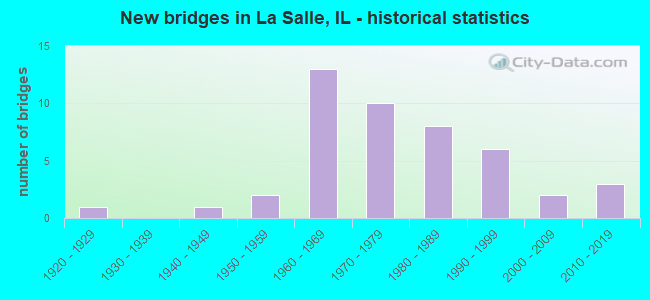
- New bridges - historical statistics
- 11920-1929
- 11940-1949
- 21950-1959
- 131960-1969
- 101970-1979
- 81980-1989
- 61990-1999
- 22000-2009
- 32010-2019
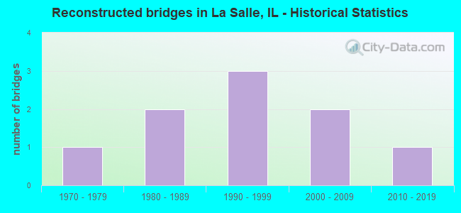
- Reconstructed bridges - Historical Statistics
- 11970-1979
- 21980-1989
- 31990-1999
- 22000-2009
- 12010-2019
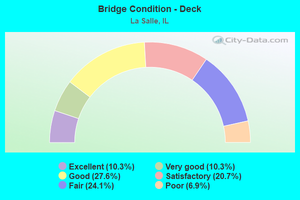
- Bridge Condition - Deck
- 10.3%Excellent
- 10.3%Very good
- 27.6%Good
- 20.7%Satisfactory
- 24.1%Fair
- 6.9%Poor
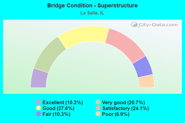
- Bridge Condition - Superstructure
- 10.3%Excellent
- 20.7%Very good
- 27.6%Good
- 24.1%Satisfactory
- 10.3%Fair
- 6.9%Poor
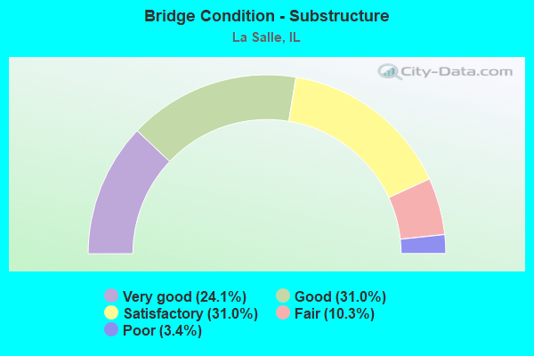
- Bridge Condition - Substructure
- 24.1%Very good
- 31.0%Good
- 31.0%Satisfactory
- 10.3%Fair
- 3.4%Poor
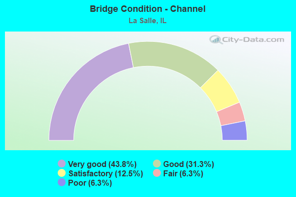
- Bridge Condition - Channel
- 43.8%Very good
- 31.3%Good
- 12.5%Satisfactory
- 6.3%Fair
- 6.3%Poor
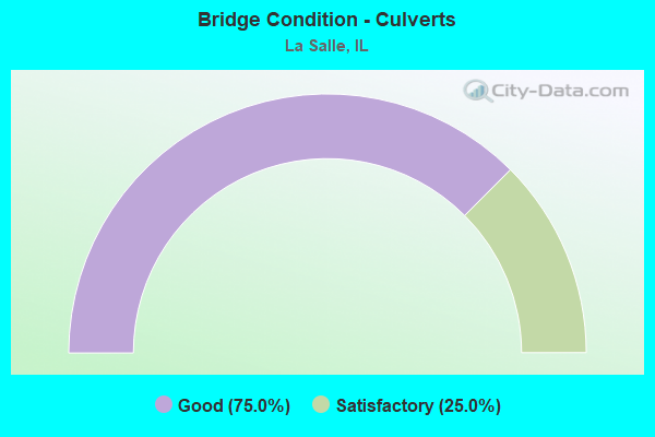
- Bridge Condition - Culverts
- 75.0%Good
- 25.0%Satisfactory
Find on map >> Show street view
Structure Number: 500003, Location: 1.1 MI E JCT IL 251 (Lat: 41.369331, Lng: -89.106161), Route carried "on" structure: Interstate 80, Year Built: 1961, Year Reconstructed: 2021, Status: Open, Structure Length: 1.38m (4.53ft), Average Daily Traffic: 12,750 (year 2019), Truck Traffic: 43%, Average Future Daily Traffic: 13,683 (year 2032), Design Load: HS 25 or greater, Features Intersected: E 3rd Road (MS 6100A)
Minimum Vertical Clearance: 30+ m (98+ ft), Kilometerpoint: 122.500, Lanes on structure: 2, Lanes under structure: 2, Base Highway Network: Yes, Owner: State Highway Agency, Approaching Roadway Width: 11.6m (38.1ft), Skew: 4 degrees, Material/Design: Steel, Design/Construction: Stringer/Multi-beam, Number Of Spans In Main Unit: 1, Length of Maximum Span: 13.2m (43.3ft), Curb-To-Curb Width: 12.3m (40.4ft), Out-to-Out Width: 13.2m (43.3ft)
Condition: Deck: Excellent, Superstructure: Excellent, Substructure: Good, Operating Rating: 42.8 metric tons, Method Used To Determine Operating Rating: Load Factor (LF) rating reported by rating factor (RF) method using MS18 loading, Inventory Rating: 25.6 metric tons, Method Used To Determine Inventory Rating: Load Factor (LF) rating reported by rating factor (RF) method using MS18 loading, Structural Evaluation: Equal to present minimum criteria, Deck Geometry: Better than present minimum criteria, Underclear: High priority of corrective action, Approach Roadway Alignment: Equal to present desirable criteria, Designated Inspection Frequency: Every 24 months, Inspection Date: September 2021, Deck Structure Type: Concrete Cast-file-Place, Wearing Surface/Protective System: Deck Protection: Epoxy Coated Reinforcing
Find on map >> Show street view
Structure Number: 500004, Location: 1.1 MI E JCT IL 251 (Lat: 41.369392, Lng: -89.106072), Route carried "on" structure: Interstate 80, Year Built: 1961, Year Reconstructed: 2021, Status: Open, Structure Length: 1.38m (4.53ft), Average Daily Traffic: 12,750 (year 2019), Truck Traffic: 43%, Average Future Daily Traffic: 13,683 (year 2032), Design Load: HS 25 or greater, Features Intersected: E 3rd Road (MS 6100A)
Minimum Vertical Clearance: 30+ m (98+ ft), Kilometerpoint: 122.516, Lanes on structure: 2, Lanes under structure: 2, Base Highway Network: Yes, Owner: State Highway Agency, Approaching Roadway Width: 11.6m (38.1ft), Skew: 4 degrees, Material/Design: Steel, Design/Construction: Stringer/Multi-beam, Number Of Spans In Main Unit: 1, Length of Maximum Span: 13.2m (43.3ft), Curb-To-Curb Width: 12.3m (40.4ft), Out-to-Out Width: 13.2m (43.3ft)
Condition: Deck: Excellent, Superstructure: Excellent, Substructure: Good, Operating Rating: 37.6 metric tons, Method Used To Determine Operating Rating: Load Factor (LF) rating reported by rating factor (RF) method using MS18 loading, Inventory Rating: 22.7 metric tons, Method Used To Determine Inventory Rating: Load Factor (LF) rating reported by rating factor (RF) method using MS18 loading, Structural Evaluation: Somewhat better than minimum adequacy, Deck Geometry: Better than present minimum criteria, Underclear: High priority of corrective action, Approach Roadway Alignment: Equal to present desirable criteria, Designated Inspection Frequency: Every 24 months, Inspection Date: September 2021, Deck Structure Type: Concrete Cast-file-Place, Wearing Surface/Protective System: Deck Protection: Epoxy Coated Reinforcing
Find on map >> Show street view
Structure Number: 500007, Location: 5.3 MI E JCT IL 251 (Lat: 41.367881, Lng: -89.028719), Route carried "on" structure: Interstate 80, Year Built: 1961, Year Reconstructed: 2003, Status: Open, Structure Length: 4.57m (14.99ft), Average Daily Traffic: 15,700 (year 2021), Truck Traffic: 25%, Average Future Daily Traffic: 17,202 (year 2032), Design Load: HS 20+Mod, Features Intersected: PECUMSAUGAN CRK
Minimum Vertical Clearance: 30+ m (98+ ft), Kilometerpoint: 129.179, Lanes on structure: 2, Base Highway Network: Yes, Owner: State Highway Agency, Approaching Roadway Width: 13.4m (44.0ft), Material/Design: Prestressed concrete, Design/Construction: Stringer/Multi-beam, Number Of Spans In Main Unit: 3, Length of Maximum Span: 14.9m (48.9ft), Curb-To-Curb Width: 12.2m (40.0ft), Out-to-Out Width: 13.1m (43.0ft)
Condition: Deck: Good, Superstructure: Very good, Substructure: Satisfactory, Channel: Good, Operating Rating: 65.4 metric tons, Method Used To Determine Operating Rating: Load Factor (LF) rating reported by rating factor (RF) method using MS18 loading, Inventory Rating: 39.2 metric tons, Method Used To Determine Inventory Rating: Load Factor (LF) rating reported by rating factor (RF) method using MS18 loading, Structural Evaluation: Equal to present minimum criteria, Deck Geometry: Better than present minimum criteria, Waterway Adequacy: Equal to present desirable criteria, Approach Roadway Alignment: Equal to present desirable criteria, Length Of Structure Improvement: 5.49m (18.01ft), Designated Inspection Frequency: Every 24 months, Inspection Date: December 2020, Bridge Improvement Cost: $832,000, Roadway Improvement Cost: $83,000, Total Project Cost: $1,248,000, Deck Structure Type: Concrete Cast-file-Place, Wearing Surface/Protective System: Deck Protection: Epoxy Coated Reinforcing
Find on map >> Show street view
Structure Number: 500008, Location: 5.3 MI E OF IL 251 (Lat: 41.367881, Lng: -89.028533), Route carried "on" structure: Interstate 80, Year Built: 1961, Year Reconstructed: 2003, Status: Open, Structure Length: 4.57m (14.99ft), Average Daily Traffic: 15,700 (year 2021), Truck Traffic: 25%, Average Future Daily Traffic: 17,202 (year 2032), Design Load: HS 20+Mod, Features Intersected: PECUMSAUGAN CRK
Minimum Vertical Clearance: 30+ m (98+ ft), Kilometerpoint: 129.195, Lanes on structure: 2, Base Highway Network: Yes, Owner: State Highway Agency, Approaching Roadway Width: 13.4m (44.0ft), Material/Design: Prestressed concrete, Design/Construction: Stringer/Multi-beam, Number Of Spans In Main Unit: 3, Length of Maximum Span: 14.9m (48.9ft), Curb-To-Curb Width: 12.2m (40.0ft), Out-to-Out Width: 13.1m (43.0ft)
Condition: Deck: Very good, Superstructure: Very good, Substructure: Satisfactory, Channel: Good, Operating Rating: 65.4 metric tons, Method Used To Determine Operating Rating: Load Factor (LF) rating reported by rating factor (RF) method using MS18 loading, Inventory Rating: 39.2 metric tons, Method Used To Determine Inventory Rating: Load Factor (LF) rating reported by rating factor (RF) method using MS18 loading, Structural Evaluation: Equal to present minimum criteria, Deck Geometry: Better than present minimum criteria, Waterway Adequacy: Equal to present desirable criteria, Approach Roadway Alignment: Equal to present desirable criteria, Length Of Structure Improvement: 5.49m (18.01ft), Designated Inspection Frequency: Every 24 months, Inspection Date: December 2020, Bridge Improvement Cost: $827,000, Roadway Improvement Cost: $83,000, Total Project Cost: $1,241,000, Deck Structure Type: Concrete Cast-file-Place, Wearing Surface/Protective System: Deck Protection: Epoxy Coated Reinforcing
Find on map >> Show street view
Structure Number: 500017, Location: 0.20 MI S OF US 6 (Lat: 41.325403, Lng: -89.093672), Route carried "on" structure: State highway 351, Year Built: 1953, Year Reconstructed: 2001, Status: Open, Structure Length: 20.18m (66.21ft), Average Daily Traffic: 4,750 (year 2019), Truck Traffic: 3%, Average Future Daily Traffic: 7,149 (year 2032), Design Load: HS 20, Features Intersected: I & M CANAL Buzzi RR
Minimum Vertical Clearance: 30+ m (98+ ft), Kilometerpoint: 8.481, Lanes on structure: 2, Base Highway Network: Yes, Owner: State Highway Agency, Approaching Roadway Width: 9.6m (31.5ft), Material/Design: Steel continuous, Design/Construction: Stringer/Multi-beam, Number Of Spans In Main Unit: 12, Length of Maximum Span: 21.9m (71.9ft), Curb or Sidewalk Widths: Left: 0.0m, Right: 1.5m (4.9ft), Curb-To-Curb Width: 9.6m (31.5ft), Out-to-Out Width: 11.8m (38.7ft)
Condition: Deck: Good, Superstructure: Very good, Substructure: Good, Channel: Very good, Operating Rating: 78.1 metric tons, Method Used To Determine Operating Rating: Load Factor (LF) rating reported by rating factor (RF) method using MS18 loading, Inventory Rating: 46.7 metric tons, Method Used To Determine Inventory Rating: Load Factor (LF) rating reported by rating factor (RF) method using MS18 loading, Structural Evaluation: Better than present minimum criteria, Deck Geometry: Meets minimum limits, Underclear: Somewhat better than minimum adequacy, Waterway Adequacy: Equal to present desirable criteria, Approach Roadway Alignment: Equal to present minimum criteria, Length Of Structure Improvement: 20.33m (66.70ft), Designated Inspection Frequency: Every 48 months, Inspection Date: Febuary 2021, Bridge Improvement Cost: $1,728,000, Roadway Improvement Cost: $173,000, Total Project Cost: $2,592,000, Deck Structure Type: Concrete Cast-file-Place, Wearing Surface/Protective System: Deck Protection: Epoxy Coated Reinforcing
Find on map >> Show street view
Structure Number: 500093, Location: 3.2 ME JC 51 & I 80 (Lat: 41.368914, Lng: -89.067661), Route carried "on" structure: County highway , Year Built: 1961, Year Reconstructed: 1979, Status: Open, Structure Length: 7.86m (25.79ft), Average Daily Traffic: 625 (year 2020), Truck Traffic: 5%, Average Future Daily Traffic: 726 (year 2032), Design Load: HS 20, Features Intersected: I-80, Facility Carried by Structure: CH 13 FAS 260
Minimum Vertical Clearance: 30+ m (98+ ft), Kilometerpoint: 17.622, Lanes on structure: 2, Lanes under structure: 4, Owner: State Highway Agency, Approaching Roadway Width: 6.7m (22.0ft), Skew: 2 degrees, Material/Design: Steel continuous, Design/Construction: Stringer/Multi-beam, Number Of Spans In Main Unit: 2, Number Of Approach Spans: 2, Length of Maximum Span: 32.3m (106.0ft), Curb-To-Curb Width: 9.9m (32.5ft), Out-to-Out Width: 11.0m (36.1ft)
Condition: Deck: Satisfactory, Superstructure: Good, Substructure: Good, Operating Rating: 58.6 metric tons, Method Used To Determine Operating Rating: Load Factor (LF) rating reported by rating factor (RF) method using MS18 loading, Inventory Rating: 35.3 metric tons, Method Used To Determine Inventory Rating: Load Factor (LF) rating reported by rating factor (RF) method using MS18 loading, Structural Evaluation: Better than present minimum criteria, Deck Geometry: Equal to present minimum criteria, Underclear: Somewhat better than minimum adequacy, Approach Roadway Alignment: Equal to present desirable criteria, Designated Inspection Frequency: Every 24 months, Inspection Date: December 2020, Deck Structure Type: Concrete Cast-file-Place, Wearing Surface/Protective System: Wearing Surface: Bituminous, Membrane: Built-up
Find on map >> Show street view
Structure Number: 500094, Location: 2.15 MI E OF IL 251 (Lat: 41.333311, Lng: -89.081881), Route carried "on" structure: US 6, Year Built: 1966, Year Reconstructed: 2007, Status: Open, Structure Length: 8.90m (29.20ft), Average Daily Traffic: 9,850 (year 2021), Truck Traffic: 16%, Average Future Daily Traffic: 8,768 (year 2032), Design Load: HS 20, Features Intersected: LITTLE VERMILION R
Minimum Vertical Clearance: 30+ m (98+ ft), Kilometerpoint: 137.177, Lanes on structure: 2, Base Highway Network: Yes, Owner: State Highway Agency, Approaching Roadway Width: 9.4m (30.8ft), Material/Design: Steel continuous, Design/Construction: Stringer/Multi-beam, Number Of Spans In Main Unit: 3, Number Of Approach Spans: 2, Length of Maximum Span: 34.2m (112.2ft), Curb or Sidewalk Widths: Left: 1.5m (4.9ft), Right: 0.0m, Curb-To-Curb Width: 9.4m (30.8ft), Out-to-Out Width: 12.2m (40.0ft)
Condition: Deck: Good, Superstructure: Fair, Substructure: Very good, Channel: Good, Operating Rating: 79.1 metric tons, Method Used To Determine Operating Rating: Load Factor (LF) rating reported by rating factor (RF) method using MS18 loading, Inventory Rating: 47.3 metric tons, Method Used To Determine Inventory Rating: Load Factor (LF) rating reported by rating factor (RF) method using MS18 loading, Structural Evaluation: Somewhat better than minimum adequacy, Deck Geometry: Meets minimum limits, Waterway Adequacy: Equal to present desirable criteria, Approach Roadway Alignment: Equal to present desirable criteria, Designated Inspection Frequency: Every 24 months, Inspection Date: Febuary 2020, Deck Structure Type: Concrete Cast-file-Place, Wearing Surface/Protective System: Deck Protection: Epoxy Coated Reinforcing
Find on map >> Show street view
Structure Number: 500115, Location: 5.0 MI E OF ILL 251 (Lat: 41.353711, Lng: -89.039242), Route carried "on" structure: US 6, Year Built: 1954, Status: Open, Structure Length: 1.58m (5.18ft), Average Daily Traffic: 7,200 (year 2021), Truck Traffic: 8%, Average Future Daily Traffic: 8,433 (year 2032), Design Load: H 20, Features Intersected: PECUMSAGAN CR
Minimum Vertical Clearance: 30+ m (98+ ft), Kilometerpoint: 141.699, Lanes on structure: 2, Base Highway Network: Yes, Owner: State Highway Agency, Approaching Roadway Width: 13.4m (44.0ft), Material/Design: Concrete continuous, Design/Construction: Slab, Number Of Spans In Main Unit: 3, Length of Maximum Span: 4.9m (16.1ft), Curb-To-Curb Width: 13.4m (44.0ft), Out-to-Out Width: 13.4m (44.0ft)
Condition: Deck: Fair, Superstructure: Fair, Substructure: Fair, Channel: Fair, Operating Rating: 70.0 metric tons, Method Used To Determine Operating Rating: Load Factor (LF) rating reported by rating factor (RF) method using MS18 loading, Inventory Rating: 41.8 metric tons, Method Used To Determine Inventory Rating: Load Factor (LF) rating reported by rating factor (RF) method using MS18 loading, Structural Evaluation: Somewhat better than minimum adequacy, Deck Geometry: Equal to present minimum criteria, Waterway Adequacy: Better than present minimum criteria, Approach Roadway Alignment: Equal to present minimum criteria, Designated Inspection Frequency: Every 24 months, Inspection Date: January 2022, Deck Structure Type: Concrete Cast-file-Place
Find on map >> Show street view
Structure Number: 500125, Location: 4.4 MI E OF IL 251 (Lat: 41.367839, Lng: -89.048381), Route carried "on" structure: City street , Year Built: 1961, Status: Open, Structure Length: 6.25m (20.51ft), Average Daily Traffic: 275 (year 2016), Truck Traffic: 2%, Average Future Daily Traffic: 84 (year 2032), Design Load: HS 15, Features Intersected: FAI 80, Facility Carried by Structure: MS 6460 (E 6TH RD)
Minimum Vertical Clearance: 30+ m (98+ ft), Kilometerpoint: 0.740, Lanes on structure: 2, Lanes under structure: 4, Owner: State Highway Agency, Approaching Roadway Width: 5.5m (18.0ft), Material/Design: Prestressed concrete, Design/Construction: Stringer/Multi-beam, Number Of Spans In Main Unit: 4, Length of Maximum Span: 18.3m (60.0ft), Curb-To-Curb Width: 7.3m (24.0ft), Out-to-Out Width: 9.1m (29.9ft)
Condition: Deck: Fair, Superstructure: Satisfactory, Substructure: Satisfactory, Operating Rating: 91.4 metric tons, Method Used To Determine Operating Rating: Load Factor (LF) rating reported by rating factor (RF) method using MS18 loading, Inventory Rating: 48.6 metric tons, Method Used To Determine Inventory Rating: Load Factor (LF) rating reported by rating factor (RF) method using MS18 loading, Structural Evaluation: Equal to present minimum criteria, Deck Geometry: Somewhat better than minimum adequacy, Underclear: Meets minimum limits, Approach Roadway Alignment: Equal to present minimum criteria, Designated Inspection Frequency: Every 24 months, Inspection Date: March 2020, Deck Structure Type: Concrete Cast-file-Place
Find on map >> Show street view
Structure Number: 500173, Location: 3.5 MI N OF I-80 (Lat: 41.419364, Lng: -89.058492), Route carried "on" structure: Interstate 39, Year Built: 1979, Status: Open, Structure Length: 4.15m (13.62ft), Average Daily Traffic: 9,050 (year 2021), Truck Traffic: 28%, Average Future Daily Traffic: 10,165 (year 2032), Design Load: HS 20, Features Intersected: TOMAHAWK CREEK
Minimum Vertical Clearance: 30+ m (98+ ft), Kilometerpoint: 101.788, Lanes on structure: 2, Base Highway Network: Yes, Owner: State Highway Agency, Approaching Roadway Width: 11.6m (38.1ft), Skew: 2 degrees, Material/Design: Prestressed concrete, Design/Construction: Stringer/Multi-beam, Number Of Spans In Main Unit: 2, Length of Maximum Span: 18.9m (62.0ft), Curb-To-Curb Width: 11.7m (38.4ft), Out-to-Out Width: 12.8m (42.0ft)
Condition: Deck: Fair, Superstructure: Fair, Substructure: Satisfactory, Channel: Good, Operating Rating: 50.5 metric tons, Method Used To Determine Operating Rating: Load Factor (LF) rating reported by rating factor (RF) method using MS18 loading, Inventory Rating: 30.1 metric tons, Method Used To Determine Inventory Rating: Load Factor (LF) rating reported by rating factor (RF) method using MS18 loading, Structural Evaluation: Somewhat better than minimum adequacy, Deck Geometry: Somewhat better than minimum adequacy, Waterway Adequacy: Equal to present desirable criteria, Approach Roadway Alignment: Equal to present desirable criteria, Designated Inspection Frequency: Every 24 months, Inspection Date: January 2021, Deck Structure Type: Concrete Cast-file-Place, Wearing Surface/Protective System: Wearing Surface: Other
Find on map >> Show street view
Structure Number: 500174, Location: 3.5 MI N OF I-80 (Lat: 41.419219, Lng: -89.058494), Route carried "on" structure: Interstate 39, Year Built: 1979, Status: Open, Structure Length: 4.13m (13.55ft), Average Daily Traffic: 9,050 (year 2021), Truck Traffic: 28%, Average Future Daily Traffic: 10,165 (year 2032), Design Load: HS 20, Features Intersected: TOMAHAWK CREEK
Minimum Vertical Clearance: 30+ m (98+ ft), Kilometerpoint: 101.772, Lanes on structure: 2, Base Highway Network: Yes, Owner: State Highway Agency, Approaching Roadway Width: 11.6m (38.1ft), Skew: 2 degrees, Material/Design: Prestressed concrete continuous, Design/Construction: Stringer/Multi-beam, Number Of Spans In Main Unit: 2, Length of Maximum Span: 19.5m (64.0ft), Curb-To-Curb Width: 11.7m (38.4ft), Out-to-Out Width: 12.8m (42.0ft)
Condition: Deck: Fair, Superstructure: Poor, Substructure: Satisfactory, Channel: Good, Operating Rating: 50.5 metric tons, Method Used To Determine Operating Rating: Load Factor (LF) rating reported by rating factor (RF) method using MS18 loading, Inventory Rating: 30.1 metric tons, Method Used To Determine Inventory Rating: Load Factor (LF) rating reported by rating factor (RF) method using MS18 loading, Structural Evaluation: Meets minimum limits, Deck Geometry: Somewhat better than minimum adequacy, Waterway Adequacy: Equal to present desirable criteria, Approach Roadway Alignment: Equal to present desirable criteria, Designated Inspection Frequency: Every 12 months, Inspection Date: November 2021, Deck Structure Type: Concrete Cast-file-Place, Wearing Surface/Protective System: Wearing Surface: Other
Find on map >> Show street view
Structure Number: 500175, Location: 3 MI N OF I-80 (Lat: 41.411831, Lng: -89.058789), Route carried "on" structure: County highway , Year Built: 1977, Status: Open, Structure Length: 7.83m (25.69ft), Average Daily Traffic: 625 (year 2020), Truck Traffic: 11%, Average Future Daily Traffic: 894 (year 2032), Design Load: HS 20, Features Intersected: I-39/US 51, Facility Carried by Structure: FAS 1365 - CH 33
Minimum Vertical Clearance: 30+ m (98+ ft), Kilometerpoint: 5.568, Lanes on structure: 2, Lanes under structure: 4, Owner: State Highway Agency, Approaching Roadway Width: 8.5m (27.9ft), Material/Design: Prestressed concrete, Design/Construction: Stringer/Multi-beam, Number Of Spans In Main Unit: 2, Number Of Approach Spans: 2, Length of Maximum Span: 31.7m (104.0ft), Curb-To-Curb Width: 10.4m (34.1ft), Out-to-Out Width: 10.9m (35.8ft)
Condition: Deck: Satisfactory, Superstructure: Satisfactory, Substructure: Fair, Operating Rating: 50.5 metric tons, Method Used To Determine Operating Rating: Load Factor (LF) rating reported by rating factor (RF) method using MS18 loading, Inventory Rating: 32.4 metric tons, Method Used To Determine Inventory Rating: Load Factor (LF) rating reported by rating factor (RF) method using MS18 loading, Structural Evaluation: Somewhat better than minimum adequacy, Deck Geometry: Equal to present minimum criteria, Underclear: Somewhat better than minimum adequacy, Approach Roadway Alignment: Equal to present desirable criteria, Designated Inspection Frequency: Every 24 months, Inspection Date: March 2021, Deck Structure Type: Concrete Cast-file-Place, Wearing Surface/Protective System: Wearing Surface: Bituminous, Membrane: Built-up
Find on map >> Show street view
Structure Number: 500176, Location: 1 MILE NORTH OF I-80 (Lat: 41.382769, Lng: -89.057661), Route carried "on" structure: City street , Year Built: 1977, Status: Open, Structure Length: 7.85m (25.75ft), Average Daily Traffic: 150 (year 2020), Truck Traffic: 12%, Average Future Daily Traffic: 223 (year 2032), Design Load: HS 20, Features Intersected: I-39/US 51, Facility Carried by Structure: N 31ST RD (MS1998)
Minimum Vertical Clearance: 30+ m (98+ ft), Kilometerpoint: 0.789, Lanes on structure: 2, Lanes under structure: 4, Owner: State Highway Agency, Approaching Roadway Width: 6.1m (20.0ft), Material/Design: Prestressed concrete, Design/Construction: Stringer/Multi-beam, Number Of Spans In Main Unit: 2, Number Of Approach Spans: 2, Length of Maximum Span: 31.8m (104.3ft), Curb-To-Curb Width: 8.5m (27.9ft), Out-to-Out Width: 9.1m (29.9ft)
Condition: Deck: Good, Superstructure: Satisfactory, Substructure: Good, Operating Rating: 52.2 metric tons, Method Used To Determine Operating Rating: Load Factor (LF) rating reported by rating factor (RF) method using MS18 loading, Inventory Rating: 32.4 metric tons, Method Used To Determine Inventory Rating: Load Factor (LF) rating reported by rating factor (RF) method using MS18 loading, Structural Evaluation: Equal to present minimum criteria, Deck Geometry: Equal to present minimum criteria, Underclear: Somewhat better than minimum adequacy, Approach Roadway Alignment: Equal to present desirable criteria, Designated Inspection Frequency: Every 24 months, Inspection Date: March 2021, Deck Structure Type: Concrete Cast-file-Place, Wearing Surface/Protective System: Wearing Surface: Bituminous, Membrane: Built-up
Find on map >> Show street view
Structure Number: 500177, Location: 2.55 MI W OF FAS 256 (Lat: 41.367878, Lng: -89.059069), Route carried "on" structure: Interstate 39, Year Built: 1979, Status: Open, Structure Length: 7.77m (25.49ft), Average Daily Traffic: 9,050 (year 2021), Truck Traffic: 28%, Average Future Daily Traffic: 10,165 (year 2032), Design Load: HS 20, Features Intersected: I-80
Minimum Vertical Clearance: 30+ m (98+ ft), Kilometerpoint: 96.091, Lanes on structure: 2, Lanes under structure: 4, Base Highway Network: Yes, Owner: State Highway Agency, Approaching Roadway Width: 15.8m (51.8ft), Material/Design: Prestressed concrete, Design/Construction: Stringer/Multi-beam, Number Of Spans In Main Unit: 2, Number Of Approach Spans: 2, Length of Maximum Span: 32.3m (106.0ft), Curb-To-Curb Width: 15.3m (50.2ft), Out-to-Out Width: 16.3m (53.5ft)
Condition: Deck: Fair, Superstructure: Satisfactory, Substructure: Satisfactory, Operating Rating: 55.4 metric tons, Method Used To Determine Operating Rating: Load Factor (LF) rating reported by rating factor (RF) method using MS18 loading, Inventory Rating: 33.4 metric tons, Method Used To Determine Inventory Rating: Load Factor (LF) rating reported by rating factor (RF) method using MS18 loading, Structural Evaluation: Equal to present minimum criteria, Deck Geometry: Superior to present desirable criteria, Underclear: Somewhat better than minimum adequacy, Approach Roadway Alignment: Better than present minimum criteria, Designated Inspection Frequency: Every 24 months, Inspection Date: March 2021, Deck Structure Type: Concrete Cast-file-Place, Wearing Surface/Protective System: Wearing Surface: Bituminous, Membrane: Built-up
Find on map >> Show street view
Structure Number: 500178, Location: 2.56 MI W OF FAS 256 (Lat: 41.367781, Lng: -89.059081), Route carried "on" structure: Interstate 39, Year Built: 1979, Status: Open, Structure Length: 7.77m (25.49ft), Average Daily Traffic: 9,050 (year 2021), Truck Traffic: 28%, Average Future Daily Traffic: 10,165 (year 2032), Design Load: HS 20, Features Intersected: I-80
Minimum Vertical Clearance: 30+ m (98+ ft), Kilometerpoint: 96.075, Lanes on structure: 2, Lanes under structure: 4, Base Highway Network: Yes, Owner: State Highway Agency, Approaching Roadway Width: 15.8m (51.8ft), Material/Design: Prestressed concrete, Design/Construction: Stringer/Multi-beam, Number Of Spans In Main Unit: 2, Number Of Approach Spans: 2, Length of Maximum Span: 32.3m (106.0ft), Curb-To-Curb Width: 15.3m (50.2ft), Out-to-Out Width: 17.1m (56.1ft)
Condition: Deck: Fair, Superstructure: Satisfactory, Substructure: Satisfactory, Operating Rating: 55.4 metric tons, Method Used To Determine Operating Rating: Load Factor (LF) rating reported by rating factor (RF) method using MS18 loading, Inventory Rating: 33.4 metric tons, Method Used To Determine Inventory Rating: Load Factor (LF) rating reported by rating factor (RF) method using MS18 loading, Structural Evaluation: Equal to present minimum criteria, Deck Geometry: Superior to present desirable criteria, Underclear: Equal to present minimum criteria, Approach Roadway Alignment: Equal to present desirable criteria, Designated Inspection Frequency: Every 24 months, Inspection Date: March 2021, Deck Structure Type: Concrete Cast-file-Place, Wearing Surface/Protective System: Wearing Surface: Bituminous, Membrane: Built-up
Find on map >> Show street view
Structure Number: 500194, Location: 1.0 Mile S. of I-80 (Lat: 41.353661, Lng: -89.061889), Route carried "on" structure: Other road , Year Built: 1985, Status: Open, Structure Length: 9.02m (29.59ft), Average Daily Traffic: 375 (year 2020), Truck Traffic: 12%, Average Future Daily Traffic: 614 (year 2032), Design Load: HS 20, Features Intersected: I-39/US 51, Facility Carried by Structure: FAU 6124/N.29TH RD
Minimum Vertical Clearance: 30+ m (98+ ft), Kilometerpoint: 0.386, Lanes on structure: 2, Lanes under structure: 4, Owner: State Highway Agency, Approaching Roadway Width: 6.1m (20.0ft), Skew: 2 degrees, Material/Design: Steel continuous, Design/Construction: Stringer/Multi-beam, Number Of Spans In Main Unit: 2, Number Of Approach Spans: 2, Length of Maximum Span: 38.4m (126.0ft), Curb-To-Curb Width: 8.5m (27.9ft), Out-to-Out Width: 9.5m (31.2ft)
Condition: Deck: Satisfactory, Superstructure: Good, Substructure: Good, Operating Rating: 59.3 metric tons, Method Used To Determine Operating Rating: Load Factor (LF) rating reported by rating factor (RF) method using MS18 loading, Inventory Rating: 35.6 metric tons, Method Used To Determine Inventory Rating: Load Factor (LF) rating reported by rating factor (RF) method using MS18 loading, Structural Evaluation: Better than present minimum criteria, Deck Geometry: Equal to present minimum criteria, Underclear: Somewhat better than minimum adequacy, Approach Roadway Alignment: Better than present minimum criteria, Designated Inspection Frequency: Every 24 months, Inspection Date: Febuary 2020, Deck Structure Type: Concrete Cast-file-Place, Wearing Surface/Protective System: Deck Protection: Epoxy Coated Reinforcing
Find on map >> Show street view
Structure Number: 500195, Location: 2.74 MI E OF ILL 351 (Lat: 41.336494, Lng: -89.071442), Route carried "on" structure: US 6, Year Built: 1986, Status: Open, Structure Length: 12.41m (40.72ft), Average Daily Traffic: 9,850 (year 2021), Truck Traffic: 16%, Average Future Daily Traffic: 8,433 (year 2032), Design Load: HS 20, Features Intersected: I-39/US 51
Minimum Vertical Clearance: 30+ m (98+ ft), Kilometerpoint: 138.094, Lanes on structure: 2, Lanes under structure: 4, Base Highway Network: Yes, Owner: State Highway Agency, Approaching Roadway Width: 18.3m (60.0ft), Skew: 35 degrees, Material/Design: Steel continuous, Design/Construction: Stringer/Multi-beam, Number Of Spans In Main Unit: 2, Number Of Approach Spans: 2, Length of Maximum Span: 46.3m (151.9ft), Curb-To-Curb Width: 20.1m (65.9ft), Out-to-Out Width: 21.1m (69.2ft)
Condition: Deck: Fair, Superstructure: Satisfactory, Substructure: Satisfactory, Operating Rating: 68.0 metric tons, Method Used To Determine Operating Rating: Load Factor (LF) rating reported by rating factor (RF) method using MS18 loading, Inventory Rating: 40.5 metric tons, Method Used To Determine Inventory Rating: Load Factor (LF) rating reported by rating factor (RF) method using MS18 loading, Structural Evaluation: Equal to present minimum criteria, Deck Geometry: Superior to present desirable criteria, Underclear: Somewhat better than minimum adequacy, Approach Roadway Alignment: Better than present minimum criteria, Designated Inspection Frequency: Every 24 months, Inspection Date: Febuary 2020, Deck Structure Type: Concrete Cast-file-Place, Wearing Surface/Protective System: Deck Protection: Epoxy Coated Reinforcing
Find on map >> Show street view
Structure Number: 500196, Location: 0.43 MI S OF US 6 (Lat: 41.331625, Lng: -89.073675), Route carried "on" structure: Interstate 39, Year Built: 1985, Status: Open, Structure Length: 1.31m (4.30ft), Average Daily Traffic: 19,100 (year 2021), Truck Traffic: 37%, Average Future Daily Traffic: 19,436 (year 2032), Design Load: HS 20, Features Intersected: CONVEYOR BELT/PVT RD
Minimum Vertical Clearance: 30+ m (98+ ft), Kilometerpoint: 91.666, Lanes on structure: 4, Base Highway Network: Yes, Owner: State Highway Agency, Approaching Roadway Width: 23.2m (76.1ft), Skew: 36 degrees, Material/Design: Steel, Design/Construction: Stringer/Multi-beam, Number Of Spans In Main Unit: 1, Length of Maximum Span: 12.2m (40.0ft), Curb-To-Curb Width: 25.0m (82.0ft), Out-to-Out Width: 26.9m (88.3ft)
Condition: Deck: Satisfactory, Superstructure: Good, Substructure: Good, Operating Rating: 76.1 metric tons, Method Used To Determine Operating Rating: Load Factor (LF) rating reported by rating factor (RF) method using MS18 loading, Inventory Rating: 36.0 metric tons, Method Used To Determine Inventory Rating: Load Factor (LF) rating reported by rating factor (RF) method using MS18 loading, Structural Evaluation: Better than present minimum criteria, Deck Geometry: Superior to present desirable criteria, Underclear: High priority of corrective action, Approach Roadway Alignment: Equal to present desirable criteria, Designated Inspection Frequency: Every 24 months, Inspection Date: Febuary 2020, Deck Structure Type: Concrete Cast-file-Place, Wearing Surface/Protective System: Deck Protection: Epoxy Coated Reinforcing
Find on map >> Show street view
Structure Number: 50022, Location: 2.1 MI E JCT IL 251 (Lat: 41.372086, Lng: -89.091272), Route carried "on" structure: Interstate 80, Year Built: 1996, Status: Closed, Structure Length: 13.38m (43.90ft), Average Daily Traffic: 14,350 (year 2019), Truck Traffic: 39%, Average Future Daily Traffic: 15,806 (year 2032), Design Load: HS 20, Features Intersected: LITTLE VERMILLION RV
Minimum Vertical Clearance: 30+ m (98+ ft), Kilometerpoint: 123.820, Lanes on structure: 2, Base Highway Network: Yes, Owner: State Highway Agency, Approaching Roadway Width: 12.2m (40.0ft), Material/Design: Prestressed concrete, Design/Construction: Stringer/Multi-beam, Number Of Spans In Main Unit: 4, Length of Maximum Span: 35.4m (116.1ft), Curb-To-Curb Width: 12.4m (40.7ft), Out-to-Out Width: 13.4m (44.0ft)
Condition: Deck: Poor, Superstructure: Good, Substructure: Very good, Channel: Very good, Operating Rating: 64.5 metric tons, Method Used To Determine Operating Rating: Load Factor (LF) rating reported by rating factor (RF) method using MS18 loading, Inventory Rating: 39.9 metric tons, Method Used To Determine Inventory Rating: Load Factor (LF) rating reported by rating factor (RF) method using MS18 loading, Structural Evaluation: Better than present minimum criteria, Deck Geometry: Better than present minimum criteria, Waterway Adequacy: Equal to present desirable criteria, Approach Roadway Alignment: Equal to present desirable criteria, Designated Inspection Frequency: Every 24 months, Inspection Date: August 2020, Deck Structure Type: Concrete Cast-file-Place, Wearing Surface/Protective System: Wearing Surface: Other, Deck Protection: Epoxy Coated Reinforcing
Find on map >> Show street view
Structure Number: 500221, Location: 2.1MI E IL251 JCT (Lat: 41.372078, Lng: -89.091081), Route carried "on" structure: Interstate 80, Year Built: 1996, Year Reconstructed: 2021, Status: Open, Structure Length: 13.51m (44.32ft), Average Daily Traffic: 14,350 (year 2019), Truck Traffic: 39%, Average Future Daily Traffic: 15,806 (year 2032), Design Load: HS 20, Features Intersected: LITTLE VERMILLION RV
Minimum Vertical Clearance: 30+ m (98+ ft), Kilometerpoint: 123.836, Lanes on structure: 2, Base Highway Network: Yes, Owner: State Highway Agency, Approaching Roadway Width: 12.2m (40.0ft), Material/Design: Prestressed concrete, Design/Construction: Stringer/Multi-beam, Number Of Spans In Main Unit: 4, Length of Maximum Span: 35.7m (117.1ft), Curb-To-Curb Width: 12.2m (40.0ft), Out-to-Out Width: 13.1m (43.0ft)
Condition: Deck: Excellent, Superstructure: Excellent, Substructure: Very good, Channel: Very good, Operating Rating: 73.9 metric tons, Method Used To Determine Operating Rating: Load Factor (LF) rating reported by rating factor (RF) method using MS18 loading, Inventory Rating: 45.7 metric tons, Method Used To Determine Inventory Rating: Load Factor (LF) rating reported by rating factor (RF) method using MS18 loading, Structural Evaluation: Equal to present desirable criteria, Deck Geometry: Somewhat better than minimum adequacy, Waterway Adequacy: Equal to present desirable criteria, Approach Roadway Alignment: Equal to present desirable criteria, Designated Inspection Frequency: Every 24 months, Inspection Date: August 2021, Deck Structure Type: Concrete Cast-file-Place, Wearing Surface/Protective System: Wearing Surface: Other, Deck Protection: Epoxy Coated Reinforcing
Find on map >> Show street view
Structure Number: 500228, Location: .8 MI E OF IL 251JCT (Lat: 41.367050, Lng: -89.109714), Route carried "on" structure: Interstate 80, Year Built: 1996, Status: Open, Structure Length: 3.02m (9.91ft), Average Daily Traffic: 12,750 (year 2019), Truck Traffic: 43%, Average Future Daily Traffic: 13,683 (year 2032), Design Load: HS 20, Features Intersected: FAU 6081 LASALLE RD
Minimum Vertical Clearance: 30+ m (98+ ft), Kilometerpoint: 122.065, Lanes on structure: 2, Lanes under structure: 2, Base Highway Network: Yes, Owner: State Highway Agency, Approaching Roadway Width: 12.2m (40.0ft), Skew: 2 degrees, Material/Design: Prestressed concrete, Design/Construction: Stringer/Multi-beam, Number Of Spans In Main Unit: 1, Length of Maximum Span: 26.6m (87.3ft), Curb-To-Curb Width: 12.2m (40.0ft), Out-to-Out Width: 13.1m (43.0ft)
Condition: Deck: Good, Superstructure: Good, Substructure: Good, Operating Rating: 59.9 metric tons, Method Used To Determine Operating Rating: Load Factor (LF) rating reported by rating factor (RF) method using MS18 loading, Inventory Rating: 37.3 metric tons, Method Used To Determine Inventory Rating: Load Factor (LF) rating reported by rating factor (RF) method using MS18 loading, Structural Evaluation: Better than present minimum criteria, Deck Geometry: Better than present minimum criteria, Underclear: Meets minimum limits, Approach Roadway Alignment: Equal to present desirable criteria, Designated Inspection Frequency: Every 24 months, Inspection Date: Febuary 2021, Deck Structure Type: Concrete Cast-file-Place, Wearing Surface/Protective System: Wearing Surface: Latex Concrete, Deck Protection: Epoxy Coated Reinforcing
Find on map >> Show street view
Structure Number: 500229, Location: .8 MI E JCT IL 251 (Lat: 41.366981, Lng: -89.109861), Route carried "on" structure: Interstate 80, Year Built: 1996, Status: Open, Structure Length: 2.95m (9.68ft), Average Daily Traffic: 12,750 (year 2019), Truck Traffic: 43%, Average Future Daily Traffic: 13,683 (year 2032), Design Load: HS 20, Features Intersected: FAU 6081 LASALLE RD
Minimum Vertical Clearance: 30+ m (98+ ft), Kilometerpoint: 122.049, Lanes on structure: 2, Lanes under structure: 2, Base Highway Network: Yes, Owner: State Highway Agency, Approaching Roadway Width: 12.2m (40.0ft), Skew: 1 degrees, Material/Design: Prestressed concrete, Design/Construction: Stringer/Multi-beam, Number Of Spans In Main Unit: 1, Length of Maximum Span: 26.6m (87.3ft), Curb-To-Curb Width: 12.2m (40.0ft), Out-to-Out Width: 13.2m (43.3ft)
Condition: Deck: Satisfactory, Superstructure: Good, Substructure: Good, Operating Rating: 61.6 metric tons, Method Used To Determine Operating Rating: Load Factor (LF) rating reported by rating factor (RF) method using MS18 loading, Inventory Rating: 38.2 metric tons, Method Used To Determine Inventory Rating: Load Factor (LF) rating reported by rating factor (RF) method using MS18 loading, Structural Evaluation: Better than present minimum criteria, Deck Geometry: Better than present minimum criteria, Underclear: Meets minimum limits, Approach Roadway Alignment: Equal to present desirable criteria, Designated Inspection Frequency: Every 24 months, Inspection Date: Febuary 2021, Deck Structure Type: Concrete Cast-file-Place, Wearing Surface/Protective System: Wearing Surface: Latex Concrete, Deck Protection: Epoxy Coated Reinforcing
Find on map >> Show street view
Structure Number: 50023, Location: 1.6 MI E JC ILL 251 (Lat: 41.372167, Lng: -89.096861), Route carried "on" structure: State highway 351, Year Built: 2005, Status: Open, Structure Length: 7.48m (24.54ft), Average Daily Traffic: 5,950 (year 2019), Truck Traffic: 41%, Average Future Daily Traffic: 7,372 (year 2032), Design Load: HS 20, Features Intersected: FAI 80
Minimum Vertical Clearance: 30+ m (98+ ft), Kilometerpoint: 13.743, Lanes on structure: 4, Lanes under structure: 4, Base Highway Network: Yes, Owner: State Highway Agency, Approaching Roadway Width: 14.6m (47.9ft), Skew: 30 degrees, Material/Design: Steel continuous, Design/Construction: Stringer/Multi-beam, Number Of Spans In Main Unit: 4, Length of Maximum Span: 29.3m (96.1ft), Curb-To-Curb Width: 14.9m (48.9ft), Out-to-Out Width: 16.8m (55.1ft)
Condition: Deck: Good, Superstructure: Good, Substructure: Very good, Operating Rating: 71.9 metric tons, Method Used To Determine Operating Rating: Load Factor (LF) rating reported by rating factor (RF) method using MS18 loading, Inventory Rating: 43.1 metric tons, Method Used To Determine Inventory Rating: Load Factor (LF) rating reported by rating factor (RF) method using MS18 loading, Structural Evaluation: Better than present minimum criteria, Deck Geometry: High priority of replacement, Underclear: High priority of corrective action, Approach Roadway Alignment: Equal to present desirable criteria, Designated Inspection Frequency: Every 24 months, Inspection Date: January 2021, Deck Structure Type: Concrete Cast-file-Place, Wearing Surface/Protective System: Deck Protection: Epoxy Coated Reinforcing
Find on map >> Show street view
Structure Number: 502009, Location: 0.05 M S of US 6 (Lat: 41.335778, Lng: -89.071636), Route carried "on" structure: Interstate 39, Year Built: 1961, Year Reconstructed: 1985, Status: Open, Structure Length: 0.87m (2.85ft), Average Daily Traffic: 19,100 (year 2021), Truck Traffic: 37%, Average Future Daily Traffic: 22,692 (year 2032), Design Load: HS 20, Features Intersected: SE Half Conveyor B
Minimum Vertical Clearance: 30+ m (98+ ft), Kilometerpoint: 92.277, Lanes on structure: 4, Base Highway Network: Yes, Owner: State Highway Agency, Approaching Roadway Width: 25.6m (84.0ft), Skew: 2 degrees, Material/Design: Concrete, Design/Construction: Culvert, Number Of Spans In Main Unit: 1, Length of Maximum Span: 7.8m (25.6ft), Out-to-Out Width: 43.6m (143.0ft)
Condition: Culverts: Satisfactory, Operating Rating: 89.1 metric tons, Method Used To Determine Operating Rating: Load Factor (LF) rating reported by rating factor (RF) method using MS18 loading, Inventory Rating: 89.1 metric tons, Method Used To Determine Inventory Rating: Load Factor (LF) rating reported by rating factor (RF) method using MS18 loading, Structural Evaluation: Equal to present minimum criteria, Approach Roadway Alignment: Equal to present desirable criteria, Length Of Structure Improvement: 1.77m (5.81ft), Designated Inspection Frequency: Every 24 months, Inspection Date: Febuary 2021, Bridge Improvement Cost: $344,000, Roadway Improvement Cost: $34,000, Total Project Cost: $516,000
Find on map >> Show street view
Structure Number: 502017, Location: .25 MI N OF US 6 (Lat: 41.337517, Lng: -89.072506), Route carried "on" structure: Other road , Year Built: 1985, Status: Open, Structure Length: 1.17m (3.84ft), Average Daily Traffic: 1,825 (year 2020), Truck Traffic: 25%, Average Future Daily Traffic: 2,040 (year 2032), Design Load: HS 20, Features Intersected: CONVEYOR BELT, Facility Carried by Structure: FAU6121 & I-39 SB
Minimum Vertical Clearance: 30+ m (98+ ft), Kilometerpoint: 0.386, Lanes on structure: 3, Base Highway Network: Yes (Inventory Route: 10039041, Subroute: 30), Owner: State Highway Agency, Approaching Roadway Width: 17.7m (58.1ft), Skew: 23 degrees, Material/Design: Concrete, Design/Construction: Culvert, Number Of Spans In Main Unit: 1, Length of Maximum Span: 10.7m (35.1ft), Curb-To-Curb Width: 19.5m (64.0ft), Out-to-Out Width: 19.5m (64.0ft)
Condition: Culverts: Good, Operating Rating: 67.7 metric tons, Method Used To Determine Operating Rating: Load Factor (LF) rating reported by rating factor (RF) method using MS18 loading, Inventory Rating: 40.5 metric tons, Method Used To Determine Inventory Rating: Load Factor (LF) rating reported by rating factor (RF) method using MS18 loading, Structural Evaluation: Better than present minimum criteria, Deck Geometry: Superior to present desirable criteria, Approach Roadway Alignment: Equal to present minimum criteria, Designated Inspection Frequency: Every 24 months, Inspection Date: Febuary 2020, Deck Structure Type: Concrete Cast-file-Place
Find on map >> Show street view
Structure Number: 502018, Location: 600 FT S OF US 6 (Lat: 41.335339, Lng: -89.070936), Route carried "on" structure: Other road , Year Built: 1985, Status: Open, Structure Length: 1.47m (4.82ft), Average Daily Traffic: 950 (year 2020), Truck Traffic: 18%, Average Future Daily Traffic: 1,452 (year 2032), Design Load: HS 20, Features Intersected: CONVEYOR BELT/PVT RD, Facility Carried by Structure: FAI 39 RMP#15.90
Minimum Vertical Clearance: 30+ m (98+ ft), Kilometerpoint: 0.290, Lanes on structure: 1, Base Highway Network: Yes, Owner: State Highway Agency, Approaching Roadway Width: 9.1m (29.9ft), Skew: 3 degrees, Material/Design: Concrete, Design/Construction: Culvert, Number Of Spans In Main Unit: 1, Length of Maximum Span: 13.1m (43.0ft), Curb-To-Curb Width: 9.1m (29.9ft), Out-to-Out Width: 9.1m (29.9ft)
Condition: Culverts: Good, Operating Rating: 89.1 metric tons, Method Used To Determine Operating Rating: Load Factor (LF) rating reported by rating factor (RF) method using MS18 loading, Inventory Rating: 56.7 metric tons, Method Used To Determine Inventory Rating: Load Factor (LF) rating reported by rating factor (RF) method using MS18 loading, Structural Evaluation: Better than present minimum criteria, Deck Geometry: Equal to present minimum criteria, Approach Roadway Alignment: Equal to present minimum criteria, Designated Inspection Frequency: Every 24 months, Inspection Date: Febuary 2020, Deck Structure Type: Concrete Cast-file-Place
Find on map >> Show street view
Structure Number: 50206, Location: 2.69 M E of IL 351 (Lat: 41.336147, Lng: -89.072172), Route carried "on" structure: US 6, Year Built: 1985, Status: Open, Structure Length: 1.05m (3.44ft), Average Daily Traffic: 9,850 (year 2021), Truck Traffic: 16%, Average Future Daily Traffic: 10,044 (year 2038), Features Intersected: NW Half Conveyor B
Minimum Vertical Clearance: 30+ m (98+ ft), Kilometerpoint: 138.014, Lanes on structure: 3, Base Highway Network: Yes, Owner: State Highway Agency, Approaching Roadway Width: 20.1m (65.9ft), Material/Design: Concrete, Design/Construction: Culvert, Number Of Spans In Main Unit: 1, Length of Maximum Span: 9.8m (32.2ft), Curb-To-Curb Width: 18.6m (61.0ft), Out-to-Out Width: 63.9m (209.6ft)
Condition: Channel: Very good, Culverts: Good, Structural Evaluation: Better than present minimum criteria, Deck Geometry: Superior to present desirable criteria, Waterway Adequacy: Superior to present desirable criteria, Approach Roadway Alignment: Equal to present desirable criteria, Designated Inspection Frequency: Every 48 months, Inspection Date: Febuary 2019, Deck Structure Type: Other
Find on map >> Show street view
Structure Number: 503163, Location: N 3179TH E 340 (Lat: 41.392981, Lng: -89.099389), Route carried "on" structure: County highway , Year Built: 1928, Year Reconstructed: 1980, Status: Open, Structure Length: 2.26m (7.41ft), Average Daily Traffic: 100 (year 2020), Truck Traffic: 8%, Average Future Daily Traffic: 112 (year 2032), Design Load: HS 20, Features Intersected: L VERMILLION R, Facility Carried by Structure: TR 255
Minimum Vertical Clearance: 30+ m (98+ ft), Kilometerpoint: 0.612, Lanes on structure: 2, Owner: Town or Township Highway Agency, Approaching Roadway Width: 5.5m (18.0ft), Skew: 3 degrees, Material/Design: Prestressed concrete, Design/Construction: Box Beam or Girders - Multiple, Number Of Spans In Main Unit: 3, Length of Maximum Span: 7.6m (24.9ft), Curb-To-Curb Width: 6.1m (20.0ft), Out-to-Out Width: 6.1m (20.0ft)
Condition: Deck: Satisfactory, Superstructure: Satisfactory, Substructure: Fair, Channel: Satisfactory, Operating Rating: 65.4 metric tons, Method Used To Determine Operating Rating: Load Factor (LF) rating reported by rating factor (RF) method using MS18 loading, Inventory Rating: 39.2 metric tons, Method Used To Determine Inventory Rating: Load Factor (LF) rating reported by rating factor (RF) method using MS18 loading, Structural Evaluation: Somewhat better than minimum adequacy, Deck Geometry: Somewhat better than minimum adequacy, Waterway Adequacy: Better than present minimum criteria, Approach Roadway Alignment: Somewhat better than minimum adequacy, Designated Inspection Frequency: Every 24 months, Inspection Date: June 2020, Deck Structure Type: Concrete Precast Panels
Find on map >> Show street view
Structure Number: 503172, Location: N 30TH E 410 (Lat: 41.367589, Lng: -89.084317), Route carried "on" structure: County highway , Year Built: 1965, Year Reconstructed: 2008, Status: Open, Structure Length: 3.29m (10.79ft), Average Daily Traffic: 625 (year 2020), Truck Traffic: 1%, Average Future Daily Traffic: 1,005 (year 2032), Design Load: HS 20, Features Intersected: LITTLE VERMILLION R, Facility Carried by Structure: TR 285
Minimum Vertical Clearance: 30+ m (98+ ft), Kilometerpoint: 0.515, Lanes on structure: 2, Owner: Town or Township Highway Agency, Approaching Roadway Width: 9.1m (29.9ft), Material/Design: Prestressed concrete, Design/Construction: Box Beam or Girders - Multiple, Number Of Spans In Main Unit: 2, Length of Maximum Span: 16.5m (54.1ft), Curb-To-Curb Width: 7.8m (25.6ft), Out-to-Out Width: 8.0m (26.2ft)
Condition: Deck: Good, Superstructure: Good, Substructure: Satisfactory, Channel: Satisfactory, Operating Rating: 53.8 metric tons, Method Used To Determine Operating Rating: Load Factor (LF) rating reported by rating factor (RF) method using MS18 loading, Inventory Rating: 32.4 metric tons, Method Used To Determine Inventory Rating: Load Factor (LF) rating reported by rating factor (RF) method using MS18 loading, Structural Evaluation: Equal to present minimum criteria, Deck Geometry: Meets minimum limits, Waterway Adequacy: Superior to present desirable criteria, Approach Roadway Alignment: Somewhat better than minimum adequacy, Length Of Structure Improvement: 3.29m (10.79ft), Designated Inspection Frequency: Every 24 months, Inspection Date: April 2020, Bridge Improvement Cost: $151,000, Roadway Improvement Cost: $15,000, Total Project Cost: $227,000, Deck Structure Type: Concrete Precast Panels, Wearing Surface/Protective System: Wearing Surface: Bituminous, Membrane: Built-up
Find on map >> Show street view
Structure Number: 503587, Location: N 33RD,E 415 (Lat: 41.411489, Lng: -89.083081), Route carried "on" structure: County highway , Year Built: 2010, Status: Open, Structure Length: 5.16m (16.93ft), Average Daily Traffic: 525 (year 2020), Truck Traffic: 4%, Average Future Daily Traffic: 838 (year 2032), Design Load: H 15, Features Intersected: LITTLE VERMILION, Facility Carried by Structure: CH 33 FAS 1365
Minimum Vertical Clearance: 30+ m (98+ ft), Kilometerpoint: 3.605, Lanes on structure: 2, Owner: County Highway Agency, Approaching Roadway Width: 10.2m (33.5ft), Skew: 3 degrees, Material/Design: Prestressed concrete, Design/Construction: Stringer/Multi-beam, Number Of Spans In Main Unit: 3, Length of Maximum Span: 17.1m (56.1ft), Curb-To-Curb Width: 9.8m (32.2ft), Out-to-Out Width: 10.7m (35.1ft)
Condition: Deck: Good, Superstructure: Very good, Substructure: Very good, Channel: Very good, Operating Rating: 80.0 metric tons, Method Used To Determine Operating Rating: Load Factor (LF) rating reported by rating factor (RF) method using MS18 loading, Inventory Rating: 48.0 metric tons, Method Used To Determine Inventory Rating: Load Factor (LF) rating reported by rating factor (RF) method using MS18 loading, Structural Evaluation: Equal to present desirable criteria, Deck Geometry: Equal to present minimum criteria, Waterway Adequacy: Superior to present desirable criteria, Approach Roadway Alignment: Equal to present desirable criteria, Designated Inspection Frequency: Every 48 months, Inspection Date: August 2020, Deck Structure Type: Concrete Cast-file-Place, Wearing Surface/Protective System: Deck Protection: Epoxy Coated Reinforcing
Find on map >> Show street view
Structure Number: 503594, Location: N 33RD E 515 (Lat: 41.411731, Lng: -89.065269), Route carried "on" structure: County highway , Year Built: 2011, Status: Open, Structure Length: 3.14m (10.30ft), Average Daily Traffic: 625 (year 2020), Truck Traffic: 11%, Average Future Daily Traffic: 894 (year 2032), Design Load: HS 25 or greater, Features Intersected: TOMAHAWK CREEK, Facility Carried by Structure: FAS 1356 (CH33)
Minimum Vertical Clearance: 30+ m (98+ ft), Kilometerpoint: 5.069, Lanes on structure: 2, Owner: County Highway Agency, Approaching Roadway Width: 6.7m (22.0ft), Skew: 3 degrees, Material/Design: Prestressed concrete, Design/Construction: Stringer/Multi-beam, Number Of Spans In Main Unit: 1, Length of Maximum Span: 30.3m (99.4ft), Curb-To-Curb Width: 9.8m (32.2ft), Out-to-Out Width: 10.7m (35.1ft)
Condition: Deck: Very good, Superstructure: Very good, Substructure: Very good, Channel: Very good, Operating Rating: 44.1 metric tons, Method Used To Determine Operating Rating: Assigned rating based on Load Factor Design (LFD) reported by rating factor (RF) using MS18 loading, Inventory Rating: 32.4 metric tons, Method Used To Determine Inventory Rating: Assigned rating based on Load Factor Design (LFD) reported by rating factor (RF) using MS18 loading, Structural Evaluation: Equal to present desirable criteria, Deck Geometry: Equal to present minimum criteria, Waterway Adequacy: Superior to present desirable criteria, Approach Roadway Alignment: Equal to present desirable criteria, Designated Inspection Frequency: Every 48 months, Inspection Date: May 2021, Deck Structure Type: Concrete Cast-file-Place, Wearing Surface/Protective System: Deck Protection: Epoxy Coated Reinforcing
Find on map >> Show street view
Structure Number: 503604, Location: E 5TH, N 3225 (Lat: 41.401447, Lng: -89.068861), Route carried "on" structure: County highway , Year Built: 2013, Status: Open, Structure Length: 3.35m (10.99ft), Average Daily Traffic: 625 (year 2020), Truck Traffic: 5%, Average Future Daily Traffic: 726 (year 2032), Design Load: HS 25 or greater, Features Intersected: TOMAHAWK CREEK, Facility Carried by Structure: FAS 260 CH 13
Minimum Vertical Clearance: 30+ m (98+ ft), Kilometerpoint: 14.033, Lanes on structure: 2, Owner: County Highway Agency, Approaching Roadway Width: 9.4m (30.8ft), Skew: 3 degrees, Material/Design: Prestressed concrete, Design/Construction: Stringer/Multi-beam, Number Of Spans In Main Unit: 1, Length of Maximum Span: 32.5m (106.6ft), Curb-To-Curb Width: 9.1m (29.9ft), Out-to-Out Width: 10.1m (33.1ft)
Condition: Deck: Very good, Superstructure: Very good, Substructure: Very good, Channel: Very good, Operating Rating: 42.1 metric tons, Method Used To Determine Operating Rating: Assigned ratings based on Load and Resistance Factor Design (LRFD) reported by rating factor (RF) using HL93 loadings, Inventory Rating: 32.4 metric tons, Method Used To Determine Inventory Rating: Assigned ratings based on Load and Resistance Factor Design (LRFD) reported by rating factor (RF) using HL93 loadings, Structural Evaluation: Equal to present desirable criteria, Deck Geometry: Equal to present minimum criteria, Waterway Adequacy: Superior to present desirable criteria, Approach Roadway Alignment: Equal to present desirable criteria, Designated Inspection Frequency: Every 24 months, Inspection Date: April 2021, Deck Structure Type: Concrete Cast-file-Place, Wearing Surface/Protective System: Deck Protection: Epoxy Coated Reinforcing
Find on map >> Show street view
Structure Number: 506502, Location: E OF UNION ST (Lat: 41.327894, Lng: -89.083400), Route carried "on" structure: City street , Year Built: 1940, Year Reconstructed: 2010, Status: Posted for load, Structure Length: 4.82m (15.81ft), Average Daily Traffic: 250 (year 2020), Truck Traffic: 7%, Average Future Daily Traffic: 307 (year 2032), Features Intersected: VERMILION RIVER, Facility Carried by Structure: ROCKWELL RD
Minimum Vertical Clearance: 30+ m (98+ ft), Kilometerpoint: 0.274, Lanes on structure: 2, Owner: City or Municipal Highway Agency, Approaching Roadway Width: 6.1m (20.0ft), Material/Design: Steel, Design/Construction: Truss - Deck, Number Of Spans In Main Unit: 2, Length of Maximum Span: 32.3m (106.0ft), Curb or Sidewalk Widths: Left: 0.0m, Right: 0.6m (2.0ft), Curb-To-Curb Width: 6.1m (20.0ft), Out-to-Out Width: 6.9m (22.6ft)
Condition: Deck: Poor, Superstructure: Poor, Substructure: Poor, Channel: Poor, Operating Rating: 20.4 metric tons, Method Used To Determine Operating Rating: Load Factor (LF) rating reported by rating factor (RF) method using MS18 loading, Inventory Rating: 12.3 metric tons, Method Used To Determine Inventory Rating: Load Factor (LF) rating reported by rating factor (RF) method using MS18 loading, Structural Evaluation: Meets minimum limits, Deck Geometry: Meets minimum limits, Waterway Adequacy: Superior to present desirable criteria, Approach Roadway Alignment: Equal to present minimum criteria, Bridge Posting: Required (Relationship of Operating Rating to Maximum Legal Load: > 39.9% below), Length Of Structure Improvement: 5.79m (19.00ft), Designated Inspection Frequency: Every 24 months, Critical Feature Inspection Frequency: Every 24 months, Inspection Date: August 2021, Critical Feature Inspection Date: August 2021, Bridge Improvement Cost: $377,000, Roadway Improvement Cost: $38,000, Total Project Cost: $566,000, Deck Structure Type: Concrete Cast-file-Place
Find on map >> Show street view
Structure Number: 500003, Location: 1.1 MI E JCT IL 251 (Lat: 41.369069, Lng: -89.106156), Route carried "under" structure: City street , Year Built: 1961, Structure Length: 0. m, Average Daily Traffic: 950 (year 2020), Truck Traffic: 39%, Features Intersected: E 3rd Road (MS 6100A), Facility Carried by Structure: FAI-80 EB
Minimum Vertical Clearance: 4.60m (15.09ft), Kilometerpoint: 0.080, Lanes on structure: 2, Lanes under structure: 2, Material/Design: Steel, Design/Construction: Stringer/Multi-beam, Length of Maximum Span: 13.2m (43.3ft)
Find on map >> Show street view
Structure Number: 500004, Location: 1.1 MI E JCT IL 251 (Lat: 41.369331, Lng: -89.106161), Route carried "under" structure: City street , Year Built: 1961, Structure Length: 0. m, Average Daily Traffic: 950 (year 2020), Truck Traffic: 39%, Features Intersected: E 3rd Road (MS 6100A), Facility Carried by Structure: FAI-80 WB
Minimum Vertical Clearance: 4.34m (14.24ft), Kilometerpoint: 0.048, Lanes on structure: 2, Lanes under structure: 2, Material/Design: Steel, Design/Construction: Stringer/Multi-beam, Length of Maximum Span: 13.2m (43.3ft)
Find on map >> Show street view
Structure Number: 500093, Location: 3.2 ME JC 51 & I 80 (Lat: 41.368914, Lng: -89.067661), Route carried "under" structure: Interstate 80, Year Built: 1961, Structure Length: 0. m, Average Daily Traffic: 28,700 (year 2019), Truck Traffic: 39%, Features Intersected: I-80, Facility Carried by Structure: CH 13 FAS 260
Minimum Vertical Clearance: 4.88m (16.01ft), Kilometerpoint: 125.847, Lanes on structure: 2, Lanes under structure: 4, Material/Design: Steel continuous, Design/Construction: Stringer/Multi-beam, Length of Maximum Span: 32.3m (106.0ft)
Find on map >> Show street view
Structure Number: 500125, Location: 4.4 MI E OF IL 251 (Lat: 41.367839, Lng: -89.048381), Route carried "under" structure: Interstate 80, Year Built: 1961, Structure Length: 0. m, Average Daily Traffic: 31,400 (year 2021), Truck Traffic: 25%, Features Intersected: FAI 80, Facility Carried by Structure: MS 6460 (E 6TH RD)
Minimum Vertical Clearance: 4.88m (16.01ft), Kilometerpoint: 127.489, Lanes on structure: 2, Lanes under structure: 4, Material/Design: Prestressed concrete, Design/Construction: Stringer/Multi-beam, Length of Maximum Span: 18.3m (60.0ft)
Find on map >> Show street view
Structure Number: 500175, Location: 3 MI N OF I-80 (Lat: 41.411831, Lng: -89.058789), Route carried "under" structure: Interstate 39, Year Built: 1977, Structure Length: 0. m, Average Daily Traffic: 18,100 (year 2021), Truck Traffic: 28%, Features Intersected: I-39/US 51, Facility Carried by Structure: FAS 1365 - CH 33
Minimum Vertical Clearance: 5.00m (16.40ft), Kilometerpoint: 100.951, Lanes on structure: 2, Lanes under structure: 4, Material/Design: Prestressed concrete, Design/Construction: Stringer/Multi-beam, Length of Maximum Span: 31.7m (104.0ft)
Find on map >> Show street view
Structure Number: 500176, Location: 1 MILE NORTH OF I-80 (Lat: 41.382769, Lng: -89.057661), Route carried "under" structure: Interstate 39, Year Built: 1977, Structure Length: 0. m, Average Daily Traffic: 18,100 (year 2021), Truck Traffic: 28%, Features Intersected: I-39/US 51, Facility Carried by Structure: N 31ST RD (MS1998)
Minimum Vertical Clearance: 5.05m (16.57ft), Kilometerpoint: 97.717, Lanes on structure: 2, Lanes under structure: 4, Material/Design: Prestressed concrete, Design/Construction: Stringer/Multi-beam, Length of Maximum Span: 31.8m (104.3ft)
Find on map >> Show street view
Structure Number: 500177, Location: 2.55 MI W OF FAS 256 (Lat: 41.367783, Lng: -89.058939), Route carried "under" structure: Interstate 80, Year Built: 1979, Structure Length: 0. m, Average Daily Traffic: 31,400 (year 2021), Truck Traffic: 25%, Features Intersected: I-80, Facility Carried by Structure: I-39NB/US 51NB
Minimum Vertical Clearance: 4.90m (16.08ft), Kilometerpoint: 126.588, Lanes on structure: 2, Lanes under structure: 4, Material/Design: Prestressed concrete, Design/Construction: Stringer/Multi-beam, Length of Maximum Span: 32.3m (106.0ft)
Find on map >> Show street view
Structure Number: 500178, Location: 2.56 MI W OF FAS 256 (Lat: 41.367781, Lng: -89.059081), Route carried "under" structure: Interstate 80, Year Built: 1979, Structure Length: 0. m, Average Daily Traffic: 31,400 (year 2021), Truck Traffic: 25%, Features Intersected: I-80, Facility Carried by Structure: I-39 SB/US 51SB
Minimum Vertical Clearance: 5.46m (17.91ft), Kilometerpoint: 126.571, Lanes on structure: 2, Lanes under structure: 4, Material/Design: Prestressed concrete, Design/Construction: Stringer/Multi-beam, Length of Maximum Span: 32.3m (106.0ft)
Find on map >> Show street view
Structure Number: 500194, Location: 1.0 Mile S. of I-80 (Lat: 41.353661, Lng: -89.061889), Route carried "under" structure: Interstate 39, Year Built: 1985, Structure Length: 0. m, Average Daily Traffic: 19,800 (year 2021), Truck Traffic: 31%, Features Intersected: I-39/US 51, Facility Carried by Structure: FAU 6124/N.29TH RD
Minimum Vertical Clearance: 5.23m (17.16ft), Kilometerpoint: 94.450, Lanes on structure: 2, Lanes under structure: 4, Material/Design: Steel continuous, Design/Construction: Stringer/Multi-beam, Length of Maximum Span: 38.4m (126.0ft)
Find on map >> Show street view
Structure Number: 500195, Location: 2.74 MI E OF ILL 351 (Lat: 41.336317, Lng: -89.071339), Route carried "under" structure: Interstate 39, Year Built: 1986, Structure Length: 0. m, Average Daily Traffic: 19,100 (year 2021), Truck Traffic: 37%, Features Intersected: I-39/US 51, Facility Carried by Structure: US 6 FAP 623
Minimum Vertical Clearance: 5.49m (18.01ft), Kilometerpoint: 92.358, Lanes on structure: 2, Lanes under structure: 4, Material/Design: Steel continuous, Design/Construction: Stringer/Multi-beam, Length of Maximum Span: 46.3m (151.9ft)
Find on map >> Show street view
Structure Number: 500228, Location: .8 MI E OF IL 251JCT (Lat: 41.366981, Lng: -89.109861), Route carried "under" structure: Other road , Year Built: 1996, Structure Length: 0. m, Average Daily Traffic: 4,400 (year 2021), Truck Traffic: 8%, Features Intersected: FAU 6081 LASALLE RD, Facility Carried by Structure: I-80 WB
Minimum Vertical Clearance: 7.06m (23.16ft), Kilometerpoint: 3.701, Lanes on structure: 2, Lanes under structure: 2, Material/Design: Prestressed concrete, Design/Construction: Stringer/Multi-beam, Length of Maximum Span: 26.6m (87.3ft)
Find on map >> Show street view
Structure Number: 500229, Location: .8 MI E JCT IL 251 (Lat: 41.366892, Lng: -89.109731), Route carried "under" structure: Other road , Year Built: 1996, Structure Length: 0. m, Average Daily Traffic: 4,400 (year 2021), Truck Traffic: 8%, Features Intersected: FAU 6081 LASALLE RD, Facility Carried by Structure: I-80 EB
Minimum Vertical Clearance: 7.04m (23.10ft), Kilometerpoint: 3.717, Lanes on structure: 2, Lanes under structure: 2, Material/Design: Prestressed concrete, Design/Construction: Stringer/Multi-beam, Length of Maximum Span: 26.6m (87.3ft)
Find on map >> Show street view
Structure Number: 50023, Location: 1.6 MI E JC ILL 251 (Lat: 41.372289, Lng: -89.096889), Route carried "under" structure: Interstate 80, Year Built: 2005, Structure Length: 0. m, Average Daily Traffic: 28,700 (year 2019), Truck Traffic: 39%, Features Intersected: FAI 80, Facility Carried by Structure: ILL 351 ST. VINCEN
Minimum Vertical Clearance: 5.51m (18.08ft), Kilometerpoint: 123.369, Lanes on structure: 4, Lanes under structure: 4, Material/Design: Steel continuous, Design/Construction: Stringer/Multi-beam, Length of Maximum Span: 29.3m (96.1ft)