Bridge Statistics for Johnstown, Pennsylvania (PA)
Condition, Traffic, Stress, Structural Evaluation, Project Costs
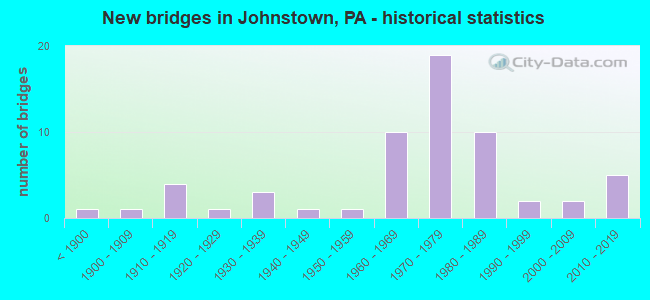
- New bridges - historical statistics
- 1Before 1900
- 11900-1909
- 41910-1919
- 11920-1929
- 31930-1939
- 11940-1949
- 11950-1959
- 101960-1969
- 191970-1979
- 101980-1989
- 21990-1999
- 22000-2009
- 52010-2019

- Reconstructed bridges - Historical Statistics
- 21970-1979
- 51980-1989
- 41990-1999
- 72000-2009
- 62010-2019


- Bridge Condition - Deck
- 7.7%Excellent
- 20.5%Very good
- 33.3%Good
- 17.9%Satisfactory
- 15.4%Fair
- 5.1%Poor

- Bridge Condition - Superstructure
- 25.6%Very good
- 33.3%Good
- 20.5%Satisfactory
- 17.9%Fair
- 2.6%Poor

- Bridge Condition - Substructure
- 12.8%Very good
- 38.5%Good
- 30.8%Satisfactory
- 12.8%Fair
- 2.6%Poor
- 2.6%Serious

- Bridge Condition - Channel
- 41.2%Very good
- 38.2%Good
- 8.8%Satisfactory
- 5.9%Fair
- 5.9%Poor

- Bridge Condition - Culverts
- 25.0%Very good
- 25.0%Good
- 50.0%Satisfactory
Find on map >> Show street view
Structure Number: 866, Location: I 79 NB OVER SR 3048 (Lat: 40.398525, Lng: -80.104769), Route carried "on" structure: Interstate 79, Year Built: 1972, Year Reconstructed: 2005, Status: Open, Structure Length: 3.63m (11.91ft), Average Daily Traffic: 36,259 (year 2022), Truck Traffic: 12%, Average Future Daily Traffic: 32,094 (year 2032), Design Load: HS 20, Features Intersected: SR 3048-NOBLESTOWN RD., Facility Carried by Structure: RAYMOND SHAFER HW
Minimum Vertical Clearance: 30+ m (98+ ft), Kilometerpoint: 10.269, Lanes on structure: 4, Lanes under structure: 10, Base Highway Network: Yes, Owner: State Highway Agency, Approaching Roadway Width: 21.9m (71.9ft), Material/Design: Steel, Design/Construction: Stringer/Multi-beam, Number Of Spans In Main Unit: 1, Length of Maximum Span: 35.1m (115.2ft), Curb or Sidewalk Widths: Left: 0.2m (0.7ft), Right: 0.2m (0.7ft), Curb-To-Curb Width: 21.4m (70.2ft), Out-to-Out Width: 22.4m (73.5ft)
Condition: Deck: Very good, Superstructure: Good, Substructure: Good, Operating Rating: 88.0 metric tons, Method Used To Determine Operating Rating: Load Factor (LF), Inventory Rating: 52.6 metric tons, Method Used To Determine Inventory Rating: Load Factor (LF), Structural Evaluation: Better than present minimum criteria, Deck Geometry: Better than present minimum criteria, Underclear: Meets minimum limits, Approach Roadway Alignment: Equal to present desirable criteria, Length Of Structure Improvement: 3.60m (11.81ft), Designated Inspection Frequency: Every 24 months, Inspection Date: May 2020, Bridge Improvement Cost: $15,000, Roadway Improvement Cost: $43,000, Total Project Cost: $197,000, Deck Structure Type: Concrete Cast-file-Place, Wearing Surface/Protective System: Wearing Surface: Monolithic Concrete, Deck Protection: Epoxy Coated Reinforcing
Find on map >> Show street view
Structure Number: 868, Location: I 79 SB OVER SR 3048 (Lat: 40.400000, Lng: -80.100000), Route carried "on" structure: Interstate 79, Year Built: 1972, Year Reconstructed: 2006, Status: Open, Structure Length: 3.63m (11.91ft), Average Daily Traffic: 43,560 (year 2021), Truck Traffic: 24%, Average Future Daily Traffic: 31,587 (year 2032), Design Load: HS 20, Features Intersected: NOBLESTOWN RD., Facility Carried by Structure: RAYMOND SHAFER HW
Minimum Vertical Clearance: 30+ m (98+ ft), Kilometerpoint: 10.261, Lanes on structure: 4, Lanes under structure: 4, Base Highway Network: Yes, Owner: State Highway Agency, Approaching Roadway Width: 17.1m (56.1ft), Skew: 10 degrees, Material/Design: Steel, Design/Construction: Stringer/Multi-beam, Number Of Spans In Main Unit: 1, Length of Maximum Span: 35.1m (115.2ft), Curb or Sidewalk Widths: Left: 0.2m (0.7ft), Right: 0.2m (0.7ft), Curb-To-Curb Width: 21.9m (71.9ft), Out-to-Out Width: 25.6m (84.0ft)
Condition: Deck: Very good, Superstructure: Good, Substructure: Good, Operating Rating: 94.3 metric tons, Method Used To Determine Operating Rating: Load Factor (LF), Inventory Rating: 56.2 metric tons, Method Used To Determine Inventory Rating: Load Factor (LF), Structural Evaluation: Better than present minimum criteria, Deck Geometry: Better than present minimum criteria, Underclear: Meets minimum limits, Approach Roadway Alignment: Equal to present desirable criteria, Length Of Structure Improvement: 3.60m (11.81ft), Designated Inspection Frequency: Every 24 months, Inspection Date: May 2020, Bridge Improvement Cost: $63,000, Roadway Improvement Cost: $187,000, Total Project Cost: $855,000, Deck Structure Type: Concrete Cast-file-Place, Wearing Surface/Protective System: Wearing Surface: Monolithic Concrete, Deck Protection: Epoxy Coated Reinforcing
Find on map >> Show street view
Structure Number: 877, Location: I-79 N.B. OVER 0376 EB-WB (Lat: 40.425422, Lng: -80.106103), Route carried "on" structure: Interstate 79, Year Built: 1973, Year Reconstructed: 2005, Status: Open, Structure Length: 5.03m (16.50ft), Average Daily Traffic: 34,254 (year 2021), Truck Traffic: 17%, Average Future Daily Traffic: 13,533 (year 2032), Design Load: HS 20, Features Intersected: SR 0022, Facility Carried by Structure: RAYMOND SHAFER HW
Minimum Vertical Clearance: 30+ m (98+ ft), Kilometerpoint: 13.488, Lanes on structure: 3, Lanes under structure: 8, Base Highway Network: Yes, Owner: State Highway Agency, Approaching Roadway Width: 17.4m (57.1ft), Skew: 13 degrees, Material/Design: Steel, Design/Construction: Stringer/Multi-beam, Number Of Spans In Main Unit: 1, Length of Maximum Span: 49.1m (161.1ft), Curb or Sidewalk Widths: Left: 0.2m (0.7ft), Right: 0.2m (0.7ft), Curb-To-Curb Width: 16.0m (52.5ft), Out-to-Out Width: 17.0m (55.8ft)
Condition: Deck: Very good, Superstructure: Very good, Substructure: Good, Operating Rating: 82.6 metric tons, Method Used To Determine Operating Rating: Load Factor (LF), Inventory Rating: 49.9 metric tons, Method Used To Determine Inventory Rating: Load Factor (LF), Structural Evaluation: Better than present minimum criteria, Deck Geometry: Equal to present minimum criteria, Underclear: High priority of corrective action, Approach Roadway Alignment: Equal to present desirable criteria, Length Of Structure Improvement: 5.00m (16.40ft), Designated Inspection Frequency: Every 48 months, Inspection Date: May 2018, Deck Structure Type: Concrete Cast-file-Place, Wearing Surface/Protective System: Wearing Surface: Monolithic Concrete, Deck Protection: Epoxy Coated Reinforcing
Find on map >> Show street view
Structure Number: 8402, Location: 0.4 MILE WEST OF TR 403 S (Lat: 40.328406, Lng: -78.925775), Route carried "on" structure: State highway 56, Year Built: 1967, Year Reconstructed: 1992, Status: Open, Structure Length: 10.33m (33.89ft), Average Daily Traffic: 14,776 (year 2022), Truck Traffic: 7%, Average Future Daily Traffic: 18,981 (year 2032), Design Load: HS 25 or greater, Features Intersected: STONY CREEK RIVER
Minimum Vertical Clearance: 30+ m (98+ ft), Kilometerpoint: 9.355, Lanes on structure: 4, Base Highway Network: Yes, Owner: State Highway Agency, Approaching Roadway Width: 21.9m (71.9ft), Skew: 34 degrees, Material/Design: Steel, Design/Construction: Stringer/Multi-beam, Number Of Spans In Main Unit: 2, Number Of Approach Spans: 1, Length of Maximum Span: 42.4m (139.1ft), Curb or Sidewalk Widths: Left: 0.2m (0.7ft), Right: 0.2m (0.7ft), Curb-To-Curb Width: 18.0m (59.1ft), Out-to-Out Width: 20.0m (65.6ft)
Condition: Deck: Satisfactory, Superstructure: Satisfactory, Substructure: Satisfactory, Channel: Good, Inventory Rating: 63.5 metric tons, Method Used To Determine Inventory Rating: Load Factor (LF), Structural Evaluation: Equal to present minimum criteria, Deck Geometry: Somewhat better than minimum adequacy, Waterway Adequacy: Superior to present desirable criteria, Approach Roadway Alignment: Somewhat better than minimum adequacy, Length Of Structure Improvement: 11.30m (37.07ft), Designated Inspection Frequency: Every 24 months, Inspection Date: March 2021, Deck Structure Type: Concrete Cast-file-Place, Wearing Surface/Protective System: Wearing Surface: Monolithic Concrete, Deck Protection: Epoxy Coated Reinforcing
Find on map >> Show street view
Structure Number: 8404, Location: 318 FEET EAST OF SR 403 S (Lat: 40.322461, Lng: -78.923606), Route carried "on" structure: State highway 56, Year Built: 1967, Year Reconstructed: 2002, Status: Open, Structure Length: 11.73m (38.48ft), Average Daily Traffic: 12,134 (year 2022), Truck Traffic: 8%, Average Future Daily Traffic: 14,769 (year 2032), Design Load: HS 20, Features Intersected: STONY CREEK RIVER
Minimum Vertical Clearance: 30+ m (98+ ft), Kilometerpoint: 10.046, Lanes on structure: 4, Base Highway Network: Yes, Owner: State Highway Agency, Approaching Roadway Width: 18.3m (60.0ft), Skew: 34 degrees, Material/Design: Steel, Design/Construction: Stringer/Multi-beam, Number Of Spans In Main Unit: 2, Number Of Approach Spans: 2, Length of Maximum Span: 40.8m (133.9ft), Curb or Sidewalk Widths: Left: 1.5m (4.9ft), Right: 0.2m (0.7ft), Curb-To-Curb Width: 17.9m (58.7ft), Out-to-Out Width: 21.1m (69.2ft)
Condition: Deck: Satisfactory, Superstructure: Satisfactory, Substructure: Poor, Channel: Fair, Operating Rating: 66.2 metric tons, Method Used To Determine Operating Rating: Load Factor (LF), Inventory Rating: 39.0 metric tons, Method Used To Determine Inventory Rating: Load Factor (LF), Structural Evaluation: Meets minimum limits, Deck Geometry: Meets minimum limits, Waterway Adequacy: Superior to present desirable criteria, Approach Roadway Alignment: Somewhat better than minimum adequacy, Length Of Structure Improvement: 14.70m (48.23ft), Designated Inspection Frequency: Every 24 months, Inspection Date: July 2021, Bridge Improvement Cost: $395,000, Roadway Improvement Cost: $1,162,000, Total Project Cost: $5,327,000, Deck Structure Type: Concrete Cast-file-Place, Wearing Surface/Protective System: Wearing Surface: Epoxy Overlay, Deck Protection: Epoxy Coated Reinforcing
Find on map >> Show street view
Structure Number: 8405, Location: OVER TR 403 & TR 271 (Lat: 40.321111, Lng: -78.922886), Route carried "on" structure: State highway 56, Year Built: 1972, Year Reconstructed: 2002, Status: Open, Structure Length: 83.15m (272.80ft), Average Daily Traffic: 12,134 (year 2022), Truck Traffic: 8%, Average Future Daily Traffic: 14,769 (year 2032), Design Load: HS 25 or greater, Features Intersected: 403,271,3016,3055,8016,R
Minimum Vertical Clearance: 30+ m (98+ ft), Kilometerpoint: 10.268, Lanes on structure: 2, Lanes under structure: 20, Base Highway Network: Yes, Owner: State Highway Agency, Approaching Roadway Width: 21.9m (71.9ft), Skew: 39 degrees, Material/Design: Steel continuous, Design/Construction: Stringer/Multi-beam, Number Of Spans In Main Unit: 27, Length of Maximum Span: 48.2m (158.1ft), Curb or Sidewalk Widths: Left: 0.2m (0.7ft), Right: 0.2m (0.7ft), Curb-To-Curb Width: 9.0m (29.5ft), Out-to-Out Width: 19.7m (64.6ft)
Condition: Deck: Satisfactory, Superstructure: Good, Substructure: Fair, Channel: Good, Operating Rating: 70.8 metric tons, Method Used To Determine Operating Rating: Load Factor (LF), Inventory Rating: 42.6 metric tons, Method Used To Determine Inventory Rating: Load Factor (LF), Structural Evaluation: Somewhat better than minimum adequacy, Deck Geometry: Meets minimum limits, Underclear: Somewhat better than minimum adequacy, Waterway Adequacy: Superior to present desirable criteria, Approach Roadway Alignment: Better than present minimum criteria, Length Of Structure Improvement: 103.90m (340.88ft), Designated Inspection Frequency: Every 24 months, Inspection Date: April 2020, Bridge Improvement Cost: $3,664,000, Roadway Improvement Cost: $10,792,000, Total Project Cost: $49,466,000, Deck Structure Type: Concrete Cast-file-Place, Wearing Surface/Protective System: Wearing Surface: Epoxy Overlay, Deck Protection: Epoxy Coated Reinforcing
Find on map >> Show street view
Structure Number: 8407, Location: OVER BECKLEY AVE. J-TOWN (Lat: 40.312539, Lng: -78.898322), Route carried "on" structure: State highway 56, Year Built: 1972, Year Reconstructed: 1994, Status: Open, Structure Length: 2.23m (7.32ft), Average Daily Traffic: 17,942 (year 2022), Truck Traffic: 6%, Average Future Daily Traffic: 26,719 (year 2032), Design Load: HS 20, Features Intersected: BECKLEY AVENUE
Minimum Vertical Clearance: 30+ m (98+ ft), Kilometerpoint: 12.580, Lanes on structure: 4, Lanes under structure: 2, Base Highway Network: Yes, Owner: State Highway Agency, Approaching Roadway Width: 21.9m (71.9ft), Skew: 33 degrees, Material/Design: Prestressed concrete, Design/Construction: Box Beam or Girders - Single/Spread, Number Of Spans In Main Unit: 1, Length of Maximum Span: 21.9m (71.9ft), Curb or Sidewalk Widths: Left: 0.2m (0.7ft), Right: 0.2m (0.7ft), Curb-To-Curb Width: 20.8m (68.2ft), Out-to-Out Width: 23.2m (76.1ft)
Condition: Deck: Satisfactory, Superstructure: Good, Substructure: Satisfactory, Operating Rating: 89.8 metric tons, Method Used To Determine Operating Rating: Load Factor (LF), Inventory Rating: 43.5 metric tons, Method Used To Determine Inventory Rating: Load Factor (LF), Structural Evaluation: Equal to present minimum criteria, Deck Geometry: Equal to present minimum criteria, Underclear: Meets minimum limits, Approach Roadway Alignment: Equal to present desirable criteria, Length Of Structure Improvement: 2.90m (9.51ft), Designated Inspection Frequency: Every 48 months, Inspection Date: April 2019, Deck Structure Type: Concrete Cast-file-Place, Wearing Surface/Protective System: Wearing Surface: Monolithic Concrete, Deck Protection: Epoxy Coated Reinforcing
Find on map >> Show street view
Structure Number: 8504, Location: 0.7 MILE SOUTH OF SR 3029 (Lat: 40.338650, Lng: -78.894117), Route carried "on" structure: State highway 271, Year Built: 1958, Year Reconstructed: 2013, Status: Open, Structure Length: 28.47m (93.41ft), Average Daily Traffic: 3,877 (year 2020), Truck Traffic: 5%, Average Future Daily Traffic: 4,546 (year 2032), Design Load: HS 20, Features Intersected: L.CONEMA.RIV;NORFOLK STH
Minimum Vertical Clearance: 5.23m (17.16ft), Kilometerpoint: 17.307, Lanes on structure: 2, Base Highway Network: Yes, Owner: Railroad, Maintenance Responsibility: State Highway Agency, Approaching Roadway Width: 10.4m (34.1ft), Material/Design: Steel, Design/Construction: Truss - Thru, Number Of Spans In Main Unit: 2, Number Of Approach Spans: 3, Length of Maximum Span: 146.3m (480.0ft), Curb or Sidewalk Widths: Left: 0.0m, Right: 2.0m (6.6ft), Curb-To-Curb Width: 10.4m (34.1ft), Out-to-Out Width: 13.4m (44.0ft)
Condition: Deck: Fair, Superstructure: Fair, Substructure: Good, Channel: Very good, Operating Rating: 46.3 metric tons, Method Used To Determine Operating Rating: Load Factor (LF), Inventory Rating: 27.2 metric tons, Method Used To Determine Inventory Rating: Load Factor (LF), Structural Evaluation: Somewhat better than minimum adequacy, Deck Geometry: Meets minimum limits, Underclear: High priority of corrective action, Waterway Adequacy: Superior to present desirable criteria, Approach Roadway Alignment: Equal to present desirable criteria, Length Of Structure Improvement: 35.60m (116.80ft), Designated Inspection Frequency: Every 24 months, Critical Feature Inspection Frequency: Every 24 months, Inspection Date: April 2020, Critical Feature Inspection Date: April 2020, Bridge Improvement Cost: $900,000, Roadway Improvement Cost: $2,651,000, Total Project Cost: $12,151,000, Deck Structure Type: Closed Grating, Wearing Surface/Protective System: Wearing Surface: Latex Concrete
Find on map >> Show street view
Structure Number: 8525, Location: 76 FEET NORTH OF SR 3041 (Lat: 40.364672, Lng: -78.941111), Route carried "on" structure: State highway 403, Year Built: 1948, Status: Open, Structure Length: 0.79m (2.59ft), Average Daily Traffic: 4,043 (year 2020), Truck Traffic: 21%, Average Future Daily Traffic: 5,550 (year 2032), Design Load: H 20, Features Intersected: LAUREL RUN
Minimum Vertical Clearance: 30+ m (98+ ft), Kilometerpoint: 9.859, Lanes on structure: 2, Owner: State Highway Agency, Approaching Roadway Width: 10.4m (34.1ft), Material/Design: Concrete, Design/Construction: Culvert, Number Of Spans In Main Unit: 1, Length of Maximum Span: 7.9m (25.9ft), Curb or Sidewalk Widths: Left: 1.4m (4.6ft), Right: 0.0m
Condition: Channel: Good, Culverts: Satisfactory, Operating Rating: 89.8 metric tons, Method Used To Determine Operating Rating: Allowable Stress (AS), Inventory Rating: 88.9 metric tons, Method Used To Determine Inventory Rating: Allowable Stress (AS), Structural Evaluation: Equal to present minimum criteria, Waterway Adequacy: Equal to present desirable criteria, Approach Roadway Alignment: Equal to present desirable criteria, Length Of Structure Improvement: 1.40m (4.59ft), Designated Inspection Frequency: Every 24 months, Inspection Date: Febuary 2021
Find on map >> Show street view
Structure Number: 8633, Location: DALE BORO. (Lat: 40.310906, Lng: -78.900853), Route carried "on" structure: State highway , Year Built: 1988, Status: Open, Structure Length: 1.10m (3.61ft), Average Daily Traffic: 6,195 (year 2020), Truck Traffic: 1%, Average Future Daily Traffic: 8,289 (year 2032), Design Load: HS 25 or greater, Features Intersected: SOLOMON RUN, Facility Carried by Structure: SR 3016,BEDFORD ST
Minimum Vertical Clearance: 30+ m (98+ ft), Kilometerpoint: 2.187, Lanes on structure: 2, Base Highway Network: Yes, Owner: State Highway Agency, Approaching Roadway Width: 10.1m (33.1ft), Skew: 3 degrees, Material/Design: Prestressed concrete, Design/Construction: Box Beam or Girders - Multiple, Number Of Spans In Main Unit: 1, Length of Maximum Span: 10.4m (34.1ft), Curb or Sidewalk Widths: Left: 1.4m (4.6ft), Right: 1.4m (4.6ft), Curb-To-Curb Width: 10.1m (33.1ft), Out-to-Out Width: 14.0m (45.9ft)
Condition: Deck: Fair, Superstructure: Very good, Substructure: Good, Channel: Good, Inventory Rating: 62.6 metric tons, Method Used To Determine Inventory Rating: Load Factor (LF), Structural Evaluation: Better than present minimum criteria, Deck Geometry: Meets minimum limits, Waterway Adequacy: Equal to present minimum criteria, Approach Roadway Alignment: Equal to present desirable criteria, Length Of Structure Improvement: 1.60m (5.25ft), Designated Inspection Frequency: Every 24 months, Inspection Date: March 2021, Deck Structure Type: Concrete Cast-file-Place, Wearing Surface/Protective System: Wearing Surface: Monolithic Concrete, Deck Protection: Epoxy Coated Reinforcing
Find on map >> Show street view
Structure Number: 8636, Location: JOHNSTOWN(INCLINE PLANE) (Lat: 40.325967, Lng: -78.925519), Route carried "on" structure: Spur State highway , Year Built: 1890, Year Reconstructed: 2001, Status: Posted for load, Structure Length: 7.22m (23.69ft), Average Daily Traffic: 28 (year 2020), Truck Traffic: 5%, Average Future Daily Traffic: 55 (year 2032), Design Load: H 15, Features Intersected: STONYCREEK RIVER, Facility Carried by Structure: SR 3022
Minimum Vertical Clearance: 3.99m (13.09ft), Kilometerpoint: 0.000, Lanes on structure: 2, Owner: State Highway Agency, Approaching Roadway Width: 5.8m (19.0ft), Material/Design: Aluminum, Iron, Design/Construction: Truss - Thru, Number Of Spans In Main Unit: 1, Length of Maximum Span: 70.1m (230.0ft), Curb or Sidewalk Widths: Left: 0.2m (0.7ft), Right: 1.4m (4.6ft), Curb-To-Curb Width: 5.1m (16.7ft), Out-to-Out Width: 7.6m (24.9ft)
Condition: Deck: Satisfactory, Superstructure: Satisfactory, Substructure: Fair, Channel: Very good, Operating Rating: 20.9 metric tons, Method Used To Determine Operating Rating: Load and Resistance Factor (LRFR), Inventory Rating: 15.4 metric tons, Method Used To Determine Inventory Rating: Load and Resistance Factor (LRFR), Structural Evaluation: Meets minimum limits, Deck Geometry: High priority of corrective action, Waterway Adequacy: Superior to present desirable criteria, Approach Roadway Alignment: Meets minimum limits, Bridge Posting: Required (Relationship of Operating Rating to Maximum Legal Load: > 39.9% below), Length Of Structure Improvement: 8.90m (29.20ft), Designated Inspection Frequency: Every 24 months, Critical Feature Inspection Frequency: Every 24 months, Other Special Inspection Frequency: Every 12 months, Inspection Date: July 2020, Critical Feature Inspection Date: July 2021, Other Special Inspection Date: July 2021, Bridge Improvement Cost: $217,000, Roadway Improvement Cost: $638,000, Total Project Cost: $2,924,000, Deck Structure Type: Wood or Timber
Find on map >> Show street view
Structure Number: 8637, Location: JOHNSTOWN (Lat: 40.329392, Lng: -78.923639), Route carried "on" structure: State highway , Year Built: 1926, Year Reconstructed: 2001, Status: Open, Structure Length: 4.33m (14.21ft), Average Daily Traffic: 1,866 (year 2022), Truck Traffic: 5%, Average Future Daily Traffic: 2,998 (year 2032), Design Load: HS 25 or greater, Features Intersected: LITTLE CONEMAUGH RIVER, Facility Carried by Structure: SR 3023(JOHNS ST.)
Minimum Vertical Clearance: 30+ m (98+ ft), Kilometerpoint: 0.000, Lanes on structure: 3, Owner: State Highway Agency, Approaching Roadway Width: 12.2m (40.0ft), Skew: 1 degrees, Material/Design: Steel, Design/Construction: Truss - Thru, Number Of Spans In Main Unit: 1, Length of Maximum Span: 41.1m (134.8ft), Curb or Sidewalk Widths: Left: 1.8m (5.9ft), Right: 1.8m (5.9ft), Curb-To-Curb Width: 12.2m (40.0ft), Out-to-Out Width: 17.2m (56.4ft)
Condition: Deck: Good, Superstructure: Very good, Substructure: Very good, Channel: Very good, Operating Rating: 73.5 metric tons, Method Used To Determine Operating Rating: Load Factor (LF), Inventory Rating: 44.5 metric tons, Method Used To Determine Inventory Rating: Load Factor (LF), Structural Evaluation: Equal to present desirable criteria, Deck Geometry: Meets minimum limits, Waterway Adequacy: Better than present minimum criteria, Approach Roadway Alignment: Equal to present desirable criteria, Length Of Structure Improvement: 5.20m (17.06ft), Designated Inspection Frequency: Every 24 months, Critical Feature Inspection Frequency: Every 24 months, Inspection Date: October 2021, Critical Feature Inspection Date: October 2021, Deck Structure Type: Concrete Cast-file-Place, Wearing Surface/Protective System: Wearing Surface: Monolithic Concrete, Deck Protection: Epoxy Coated Reinforcing
Find on map >> Show street view
Structure Number: 8658, Location: JOHNSTOWN, WALNUT ST (Lat: 40.328542, Lng: -78.920703), Route carried "on" structure: State highway , Year Built: 1918, Year Reconstructed: 2006, Status: Open, Structure Length: 4.27m (14.01ft), Average Daily Traffic: 4,547 (year 2020), Truck Traffic: 2%, Average Future Daily Traffic: 3,963 (year 2032), Design Load: HL 93, Features Intersected: LITTLE CONEMAUGH RIVER, Facility Carried by Structure: SR 3037(WALNUT ST)
Minimum Vertical Clearance: 30+ m (98+ ft), Kilometerpoint: 0.000, Lanes on structure: 2, Owner: State Highway Agency, Approaching Roadway Width: 10.7m (35.1ft), Material/Design: Prestressed concrete, Design/Construction: Box Beam or Girders - Single/Spread, Number Of Spans In Main Unit: 2, Length of Maximum Span: 20.4m (66.9ft), Curb or Sidewalk Widths: Left: 1.5m (4.9ft), Right: 1.5m (4.9ft), Curb-To-Curb Width: 10.7m (35.1ft), Out-to-Out Width: 14.6m (47.9ft)
Condition: Deck: Good, Superstructure: Very good, Substructure: Good, Channel: Very good, Operating Rating: 59.0 metric tons, Method Used To Determine Operating Rating: Load and Resistance Factor (LRFR), Inventory Rating: 40.8 metric tons, Method Used To Determine Inventory Rating: Load and Resistance Factor (LRFR), Structural Evaluation: Better than present minimum criteria, Deck Geometry: Somewhat better than minimum adequacy, Waterway Adequacy: Equal to present desirable criteria, Approach Roadway Alignment: Equal to present desirable criteria, Length Of Structure Improvement: 5.20m (17.06ft), Designated Inspection Frequency: Every 24 months, Inspection Date: October 2020, Bridge Improvement Cost: $125,000, Roadway Improvement Cost: $368,000, Total Project Cost: $1,686,000, Deck Structure Type: Concrete Cast-file-Place, Wearing Surface/Protective System: Wearing Surface: Monolithic Concrete, Deck Protection: Epoxy Coated Reinforcing
Find on map >> Show street view
Structure Number: 8659, Location: JOHNSTOWN (Lat: 40.328808, Lng: -78.918808), Route carried "on" structure: State highway , Year Built: 1987, Year Reconstructed: 2015, Status: Open, Structure Length: 21.52m (70.60ft), Average Daily Traffic: 4,547 (year 2020), Truck Traffic: 2%, Average Future Daily Traffic: 3,963 (year 2032), Design Load: HS 25 or greater, Features Intersected: NORFOLK S,C&BL RR, Facility Carried by Structure: SR 3037
Minimum Vertical Clearance: 30+ m (98+ ft), Kilometerpoint: 0.000, Lanes on structure: 2, Owner: State Highway Agency, Approaching Roadway Width: 11.9m (39.0ft), Skew: 9 degrees, Material/Design: Steel, Design/Construction: Stringer/Multi-beam, Number Of Spans In Main Unit: 1, Number Of Approach Spans: 6, Length of Maximum Span: 45.1m (148.0ft), Curb or Sidewalk Widths: Left: 0.2m (0.7ft), Right: 1.9m (6.2ft), Curb-To-Curb Width: 8.5m (27.9ft), Out-to-Out Width: 11.8m (38.7ft)
Condition: Deck: Good, Superstructure: Good, Substructure: Good, Operating Rating: 65.3 metric tons, Method Used To Determine Operating Rating: Load Factor (LF), Inventory Rating: 39.0 metric tons, Method Used To Determine Inventory Rating: Load Factor (LF), Structural Evaluation: Better than present minimum criteria, Deck Geometry: Meets minimum limits, Underclear: High priority of corrective action, Approach Roadway Alignment: Better than present minimum criteria, Length Of Structure Improvement: 22.10m (72.51ft), Designated Inspection Frequency: Every 48 months, Inspection Date: May 2020, Deck Structure Type: Concrete Cast-file-Place, Wearing Surface/Protective System: Wearing Surface: Latex Concrete, Deck Protection: Epoxy Coated Reinforcing
Find on map >> Show street view
Structure Number: 866, Location: MINERSVILLE-JOHNSTOWN (Lat: 40.341467, Lng: -78.926131), Route carried "on" structure: State highway , Year Built: 1914, Year Reconstructed: 2012, Status: Open, Structure Length: 12.80m (41.99ft), Average Daily Traffic: 841 (year 2022), Truck Traffic: 4%, Average Future Daily Traffic: 2,256 (year 2032), Design Load: HS 20, Features Intersected: LEHIGH VALLEY RR, RIVER, Facility Carried by Structure: SR 3039, 4TH AVE.
Minimum Vertical Clearance: 7.50m (24.61ft), Kilometerpoint: 0.000, Lanes on structure: 2, Lanes under structure: 2, Owner: State Highway Agency, Approaching Roadway Width: 6.7m (22.0ft), Material/Design: Steel, Design/Construction: Truss - Thru, Number Of Spans In Main Unit: 1, Number Of Approach Spans: 3, Length of Maximum Span: 82.0m (269.0ft), Curb or Sidewalk Widths: Left: 0.0m, Right: 2.3m (7.5ft), Curb-To-Curb Width: 6.7m (22.0ft), Out-to-Out Width: 7.3m (24.0ft)
Condition: Deck: Good, Superstructure: Satisfactory, Substructure: Good, Channel: Very good, Operating Rating: 66.2 metric tons, Method Used To Determine Operating Rating: Allowable Stress (AS), Inventory Rating: 39.9 metric tons, Method Used To Determine Inventory Rating: Allowable Stress (AS), Structural Evaluation: Equal to present minimum criteria, Deck Geometry: Meets minimum limits, Underclear: Meets minimum limits, Waterway Adequacy: Superior to present desirable criteria, Approach Roadway Alignment: Equal to present desirable criteria, Length Of Structure Improvement: 17.30m (56.76ft), Designated Inspection Frequency: Every 24 months, Critical Feature Inspection Frequency: Every 24 months, Inspection Date: September 2020, Critical Feature Inspection Date: September 2020, Bridge Improvement Cost: $250,000, Roadway Improvement Cost: $737,000, Total Project Cost: $3,378,000, Deck Structure Type: Concrete Cast-file-Place, Wearing Surface/Protective System: Wearing Surface: Latex Concrete
Find on map >> Show street view
Structure Number: 8664, Location: 3.5 MI.N.OF JOHNSTOWN (Lat: 40.374186, Lng: -78.930092), Route carried "on" structure: State highway , Year Built: 1962, Year Reconstructed: 1979, Status: Open, Structure Length: 2.04m (6.69ft), Average Daily Traffic: 800 (year 2022), Truck Traffic: 4%, Average Future Daily Traffic: 1,150 (year 2032), Design Load: H 20, Features Intersected: LAUREL RUN, Facility Carried by Structure: SR 3041
Minimum Vertical Clearance: 30+ m (98+ ft), Kilometerpoint: 0.911, Lanes on structure: 2, Owner: State Highway Agency, Approaching Roadway Width: 8.8m (28.9ft), Skew: 4 degrees, Material/Design: Steel, Design/Construction: Stringer/Multi-beam, Number Of Spans In Main Unit: 1, Length of Maximum Span: 20.1m (65.9ft), Curb or Sidewalk Widths: Left: 1.5m (4.9ft), Right: 1.5m (4.9ft), Curb-To-Curb Width: 8.5m (27.9ft), Out-to-Out Width: 12.3m (40.4ft)
Condition: Deck: Satisfactory, Superstructure: Good, Substructure: Satisfactory, Channel: Fair, Operating Rating: 87.1 metric tons, Method Used To Determine Operating Rating: Load Factor (LF), Inventory Rating: 51.7 metric tons, Method Used To Determine Inventory Rating: Load Factor (LF), Structural Evaluation: Equal to present minimum criteria, Deck Geometry: Somewhat better than minimum adequacy, Waterway Adequacy: Better than present minimum criteria, Approach Roadway Alignment: Equal to present desirable criteria, Length Of Structure Improvement: 2.60m (8.53ft), Designated Inspection Frequency: Every 48 months, Inspection Date: March 2019, Bridge Improvement Cost: $70,000, Roadway Improvement Cost: $264,000, Total Project Cost: $947,000, Deck Structure Type: Concrete Cast-file-Place, Wearing Surface/Protective System: Wearing Surface: Low Slump Concrete
Find on map >> Show street view
Structure Number: 8665, Location: 3.75 MI.N.OF JOHNSTOWN (Lat: 40.379144, Lng: -78.926928), Route carried "on" structure: State highway , Year Built: 1962, Year Reconstructed: 1979, Status: Open, Structure Length: 1.37m (4.49ft), Average Daily Traffic: 800 (year 2022), Truck Traffic: 4%, Average Future Daily Traffic: 1,150 (year 2032), Design Load: HS 20, Features Intersected: LAUREL RUN, Facility Carried by Structure: SR 3041
Minimum Vertical Clearance: 30+ m (98+ ft), Kilometerpoint: 2.226, Lanes on structure: 2, Owner: State Highway Agency, Approaching Roadway Width: 9.4m (30.8ft), Skew: 1 degrees, Material/Design: Steel, Design/Construction: Stringer/Multi-beam, Number Of Spans In Main Unit: 1, Length of Maximum Span: 13.4m (44.0ft), Curb or Sidewalk Widths: Left: 1.6m (5.2ft), Right: 1.6m (5.2ft), Curb-To-Curb Width: 9.8m (32.2ft), Out-to-Out Width: 13.7m (44.9ft)
Condition: Deck: Fair, Superstructure: Good, Substructure: Good, Channel: Good, Operating Rating: 67.1 metric tons, Method Used To Determine Operating Rating: Load Factor (LF), Inventory Rating: 39.9 metric tons, Method Used To Determine Inventory Rating: Load Factor (LF), Structural Evaluation: Better than present minimum criteria, Deck Geometry: Equal to present minimum criteria, Waterway Adequacy: Superior to present desirable criteria, Approach Roadway Alignment: Equal to present desirable criteria, Length Of Structure Improvement: 2.10m (6.89ft), Designated Inspection Frequency: Every 24 months, Inspection Date: October 2021, Deck Structure Type: Concrete Cast-file-Place, Wearing Surface/Protective System: Wearing Surface: Bituminous, Membrane: Preformed Fabric
Find on map >> Show street view
Structure Number: 8671, Location: JOHNSTOWN,WASHINGTON ST. (Lat: 40.330525, Lng: -78.925428), Route carried "on" structure: State highway , Year Built: 1930, Year Reconstructed: 1992, Status: Open, Structure Length: 9.05m (29.69ft), Average Daily Traffic: 3,226 (year 2020), Truck Traffic: 4%, Average Future Daily Traffic: 4,443 (year 2032), Design Load: HS 25 or greater, Features Intersected: STONYCREEK RIVER, Facility Carried by Structure: SR 3044
Minimum Vertical Clearance: 30+ m (98+ ft), Kilometerpoint: 0.000, Lanes on structure: 2, Base Highway Network: Yes, Owner: State Highway Agency, Approaching Roadway Width: 12.2m (40.0ft), Skew: 3 degrees, Material/Design: Prestressed concrete, Design/Construction: Stringer/Multi-beam, Number Of Spans In Main Unit: 2, Length of Maximum Span: 43.6m (143.0ft), Curb or Sidewalk Widths: Left: 0.2m (0.7ft), Right: 2.7m (8.9ft), Curb-To-Curb Width: 12.2m (40.0ft), Out-to-Out Width: 16.3m (53.5ft)
Condition: Deck: Good, Superstructure: Good, Substructure: Good, Channel: Good, Operating Rating: 89.8 metric tons, Method Used To Determine Operating Rating: Load Factor (LF), Inventory Rating: 49.9 metric tons, Method Used To Determine Inventory Rating: Load Factor (LF), Structural Evaluation: Better than present minimum criteria, Deck Geometry: Equal to present minimum criteria, Waterway Adequacy: Superior to present desirable criteria, Approach Roadway Alignment: Equal to present desirable criteria, Length Of Structure Improvement: 10.10m (33.14ft), Designated Inspection Frequency: Every 48 months, Inspection Date: March 2019, Deck Structure Type: Concrete Cast-file-Place, Wearing Surface/Protective System: Wearing Surface: Monolithic Concrete, Deck Protection: Epoxy Coated Reinforcing
Find on map >> Show street view
Structure Number: 868, Location: JOHNSTOWN (Lat: 40.323439, Lng: -78.919069), Route carried "on" structure: State highway , Year Built: 1900, Year Reconstructed: 2021, Status: Open, Structure Length: 7.19m (23.59ft), Average Daily Traffic: 5,192 (year 2022), Truck Traffic: 4%, Average Future Daily Traffic: 5,074 (year 2032), Design Load: H 20, Features Intersected: STONY CREEK RIVER, Facility Carried by Structure: SR 3055,FRANKLIN S
Minimum Vertical Clearance: 4.90m (16.08ft), Kilometerpoint: 0.266, Lanes on structure: 4, Owner: State Highway Agency, Approaching Roadway Width: 11.6m (38.1ft), Material/Design: Steel, Design/Construction: Truss - Thru, Number Of Spans In Main Unit: 1, Length of Maximum Span: 70.1m (230.0ft), Curb or Sidewalk Widths: Left: 2.3m (7.5ft), Right: 2.3m (7.5ft), Curb-To-Curb Width: 11.7m (38.4ft), Out-to-Out Width: 12.5m (41.0ft)
Condition: Deck: Good, Superstructure: Fair, Substructure: Good, Channel: Good, Operating Rating: 50.8 metric tons, Method Used To Determine Operating Rating: Load Factor (LF), Inventory Rating: 30.8 metric tons, Method Used To Determine Inventory Rating: Load Factor (LF), Structural Evaluation: Somewhat better than minimum adequacy, Deck Geometry: High priority of replacement, Waterway Adequacy: Equal to present minimum criteria, Approach Roadway Alignment: Equal to present desirable criteria, Length Of Structure Improvement: 9.00m (29.53ft), Designated Inspection Frequency: Every 24 months, Critical Feature Inspection Frequency: Every 24 months, Inspection Date: October 2021, Critical Feature Inspection Date: October 2021, Bridge Improvement Cost: $218,000, Roadway Improvement Cost: $642,000, Total Project Cost: $2,943,000, Deck Structure Type: Concrete Cast-file-Place, Wearing Surface/Protective System: Wearing Surface: Monolithic Concrete, Deck Protection: Galvanized Reinforcing
Find on map >> Show street view
Structure Number: 8753, Location: .25 M.S.HINCKSTON RUN DAM (Lat: 40.370714, Lng: -78.891097), Route carried "on" structure: City street , Year Built: 1910, Status: Posted for load, Structure Length: 0.79m (2.59ft), Average Daily Traffic: 103 (year 2021), Truck Traffic: 1%, Average Future Daily Traffic: 128 (year 2041), Design Load: H 10, Features Intersected: TR.OF HINCKSTON RUN, Facility Carried by Structure: T-387,HONAN AVENUE
Minimum Vertical Clearance: 30+ m (98+ ft), Kilometerpoint: 0.000, Lanes on structure: 2, Owner: Town or Township Highway Agency, Approaching Roadway Width: 4.9m (16.1ft), Material/Design: Concrete, Design/Construction: Slab, Number Of Spans In Main Unit: 2, Length of Maximum Span: 2.7m (8.9ft), Curb or Sidewalk Widths: Left: 0.2m (0.7ft), Right: 0.2m (0.7ft), Curb-To-Curb Width: 5.0m (16.4ft), Out-to-Out Width: 5.5m (18.0ft)
Condition: Deck: Fair, Superstructure: Fair, Substructure: Fair, Channel: Poor, Operating Rating: 29.9 metric tons, Method Used To Determine Operating Rating: Load Factor (LF), Inventory Rating: 18.1 metric tons, Method Used To Determine Inventory Rating: Load Factor (LF), Structural Evaluation: Somewhat better than minimum adequacy, Deck Geometry: High priority of replacement, Waterway Adequacy: Meets minimum limits, Approach Roadway Alignment: Equal to present desirable criteria, Bridge Posting: Required (Relationship of Operating Rating to Maximum Legal Load: 10.0 - 19.9% below), Length Of Structure Improvement: 0.90m (2.95ft), Designated Inspection Frequency: Every 24 months, Other Special Inspection Frequency: Every 12 months, Inspection Date: November 2020, Other Special Inspection Date: November 2020, Bridge Improvement Cost: $33,000, Roadway Improvement Cost: $165,000, Total Project Cost: $442,000, Deck Structure Type: Concrete Cast-file-Place, Wearing Surface/Protective System: Wearing Surface: Gravel
Find on map >> Show street view
Structure Number: 877, Location: JOHNSTOWN,ASH STREET (Lat: 40.308814, Lng: -78.907886), Route carried "on" structure: City street , Year Built: 1987, Year Reconstructed: 2019, Status: Open, Structure Length: 1.68m (5.51ft), Average Daily Traffic: 1,025 (year 2020), Truck Traffic: 1%, Average Future Daily Traffic: 1,314 (year 2040), Design Load: HS 25 or greater, Features Intersected: SOLOMON RUN, Facility Carried by Structure: ASH STREET
Minimum Vertical Clearance: 30+ m (98+ ft), Kilometerpoint: 0.000, Lanes on structure: 2, Owner: City or Municipal Highway Agency, Approaching Roadway Width: 8.5m (27.9ft), Skew: 6 degrees, Material/Design: Prestressed concrete, Design/Construction: Box Beam or Girders - Multiple, Number Of Spans In Main Unit: 1, Length of Maximum Span: 15.8m (51.8ft), Curb or Sidewalk Widths: Left: 1.6m (5.2ft), Right: 1.6m (5.2ft), Curb-To-Curb Width: 8.5m (27.9ft), Out-to-Out Width: 12.3m (40.4ft)
Condition: Deck: Excellent, Superstructure: Satisfactory, Substructure: Satisfactory, Channel: Satisfactory, Inventory Rating: 52.6 metric tons, Method Used To Determine Inventory Rating: Load Factor (LF), Structural Evaluation: Equal to present minimum criteria, Deck Geometry: Somewhat better than minimum adequacy, Waterway Adequacy: Better than present minimum criteria, Approach Roadway Alignment: Equal to present desirable criteria, Length Of Structure Improvement: 2.40m (7.87ft), Designated Inspection Frequency: Every 24 months, Inspection Date: January 2020, Wearing Surface/Protective System: Wearing Surface: Monolithic Concrete, Deck Protection: Epoxy Coated Reinforcing
Find on map >> Show street view
Structure Number: 8771, Location: GILBERT ST,BROWNSTOWN R (Lat: 40.338983, Lng: -78.930058), Route carried "on" structure: City street , Year Built: 1994, Status: Open, Structure Length: 1.98m (6.50ft), Average Daily Traffic: 1,762 (year 2020), Truck Traffic: 3%, Average Future Daily Traffic: 2,259 (year 2040), Design Load: HS 25 or greater, Features Intersected: NORFOLK SOUTHERN RR, Facility Carried by Structure: GILBERT ST
Minimum Vertical Clearance: 30+ m (98+ ft), Kilometerpoint: 0.000, Lanes on structure: 2, Owner: City or Municipal Highway Agency, Approaching Roadway Width: 9.8m (32.2ft), Material/Design: Prestressed concrete, Design/Construction: Box Beam or Girders - Single/Spread, Number Of Spans In Main Unit: 1, Length of Maximum Span: 19.5m (64.0ft), Curb or Sidewalk Widths: Left: 1.5m (4.9ft), Right: 0.2m (0.7ft), Curb-To-Curb Width: 9.8m (32.2ft), Out-to-Out Width: 12.6m (41.3ft)
Condition: Deck: Good, Superstructure: Good, Substructure: Satisfactory, Operating Rating: 83.5 metric tons, Method Used To Determine Operating Rating: Load Factor (LF), Inventory Rating: 48.1 metric tons, Method Used To Determine Inventory Rating: Load Factor (LF), Structural Evaluation: Equal to present minimum criteria, Deck Geometry: Somewhat better than minimum adequacy, Underclear: High priority of corrective action, Approach Roadway Alignment: Equal to present minimum criteria, Length Of Structure Improvement: 2.70m (8.86ft), Designated Inspection Frequency: Every 24 months, Inspection Date: October 2020, Deck Structure Type: Concrete Cast-file-Place, Wearing Surface/Protective System: Wearing Surface: Monolithic Concrete, Deck Protection: Epoxy Coated Reinforcing
Find on map >> Show street view
Structure Number: 8772, Location: D STREET,JOHNSTOWN (Lat: 40.347831, Lng: -78.943497), Route carried "on" structure: City street , Year Built: 1980, Year Reconstructed: 2019, Status: Open, Structure Length: 1.25m (4.10ft), Average Daily Traffic: 656 (year 2021), Truck Traffic: 1%, Average Future Daily Traffic: 918 (year 2041), Design Load: HS 20, Features Intersected: ST.CLAIR RUN, Facility Carried by Structure: D STREET
Minimum Vertical Clearance: 30+ m (98+ ft), Kilometerpoint: 0.000, Lanes on structure: 2, Owner: City or Municipal Highway Agency, Maintenance Responsibility: Town or Township Highway Agency, Approaching Roadway Width: 6.4m (21.0ft), Skew: 4 degrees, Material/Design: Prestressed concrete, Design/Construction: Box Beam or Girders - Multiple, Number Of Spans In Main Unit: 1, Length of Maximum Span: 11.9m (39.0ft), Curb or Sidewalk Widths: Left: 1.5m (4.9ft), Right: 1.5m (4.9ft), Curb-To-Curb Width: 6.4m (21.0ft), Out-to-Out Width: 10.2m (33.5ft)
Condition: Deck: Very good, Superstructure: Satisfactory, Substructure: Satisfactory, Channel: Very good, Operating Rating: 62.6 metric tons, Method Used To Determine Operating Rating: Load Factor (LF), Inventory Rating: 18.1 metric tons, Method Used To Determine Inventory Rating: Load Factor (LF), Structural Evaluation: Somewhat better than minimum adequacy, Deck Geometry: High priority of corrective action, Waterway Adequacy: Better than present minimum criteria, Approach Roadway Alignment: Equal to present desirable criteria, Length Of Structure Improvement: 1.60m (5.25ft), Designated Inspection Frequency: Every 24 months, Inspection Date: December 2019, Bridge Improvement Cost: $54,000, Roadway Improvement Cost: $264,000, Total Project Cost: $723,000, Wearing Surface/Protective System: Wearing Surface: Monolithic Concrete, Deck Protection: Epoxy Coated Reinforcing
Find on map >> Show street view
Structure Number: 8773, Location: JOHNSTOWN,FRONHEISER ST (Lat: 40.309544, Lng: -78.907022), Route carried "on" structure: City street , Year Built: 1987, Status: Open, Structure Length: 0.91m (2.99ft), Average Daily Traffic: 1,025 (year 2021), Truck Traffic: 1%, Average Future Daily Traffic: 1,435 (year 2041), Design Load: HS 25 or greater, Features Intersected: SOLOMON RUN, Facility Carried by Structure: FRONHEISER STREET
Minimum Vertical Clearance: 30+ m (98+ ft), Kilometerpoint: 0.000, Lanes on structure: 2, Owner: City or Municipal Highway Agency, Approaching Roadway Width: 7.3m (24.0ft), Skew: 2 degrees, Material/Design: Prestressed concrete, Design/Construction: Box Beam or Girders - Multiple, Number Of Spans In Main Unit: 1, Length of Maximum Span: 8.8m (28.9ft), Curb or Sidewalk Widths: Left: 2.2m (7.2ft), Right: 2.2m (7.2ft), Curb-To-Curb Width: 7.3m (24.0ft), Out-to-Out Width: 12.3m (40.4ft)
Condition: Deck: Fair, Superstructure: Fair, Substructure: Good, Channel: Good, Operating Rating: 82.6 metric tons, Method Used To Determine Operating Rating: Load Factor (LF), Inventory Rating: 46.3 metric tons, Method Used To Determine Inventory Rating: Load Factor (LF), Structural Evaluation: Somewhat better than minimum adequacy, Deck Geometry: Meets minimum limits, Waterway Adequacy: Better than present minimum criteria, Approach Roadway Alignment: Equal to present desirable criteria, Length Of Structure Improvement: 1.60m (5.25ft), Designated Inspection Frequency: Every 24 months, Inspection Date: July 2021, Deck Structure Type: Other, Wearing Surface/Protective System: Wearing Surface: Bituminous
Find on map >> Show street view
Structure Number: 8775, Location: HICKORY ST,JOHNSTOWN (Lat: 40.314278, Lng: -78.914572), Route carried "on" structure: City street , Year Built: 1937, Year Reconstructed: 2014, Status: Open, Structure Length: 7.22m (23.69ft), Average Daily Traffic: 4,961 (year 2021), Truck Traffic: 10%, Average Future Daily Traffic: 6,360 (year 2041), Design Load: H 20, Features Intersected: STONYCREEK RIVER, Facility Carried by Structure: HICKORY STREET
Minimum Vertical Clearance: 4.94m (16.21ft), Kilometerpoint: 0.000, Lanes on structure: 3, Owner: City or Municipal Highway Agency, Maintenance Responsibility: Town or Township Highway Agency, Approaching Roadway Width: 8.8m (28.9ft), Material/Design: Steel, Design/Construction: Truss - Thru, Number Of Spans In Main Unit: 1, Length of Maximum Span: 70.1m (230.0ft), Curb or Sidewalk Widths: Left: 2.0m (6.6ft), Right: 2.0m (6.6ft), Curb-To-Curb Width: 9.1m (29.9ft), Out-to-Out Width: 9.8m (32.2ft)
Condition: Deck: Very good, Superstructure: Good, Substructure: Good, Channel: Good, Operating Rating: 68.9 metric tons, Method Used To Determine Operating Rating: Load Factor (LF), Inventory Rating: 40.8 metric tons, Method Used To Determine Inventory Rating: Load Factor (LF), Structural Evaluation: Better than present minimum criteria, Deck Geometry: High priority of replacement, Waterway Adequacy: Superior to present desirable criteria, Approach Roadway Alignment: Better than present minimum criteria, Length Of Structure Improvement: 9.00m (29.53ft), Designated Inspection Frequency: Every 24 months, Critical Feature Inspection Frequency: Every 24 months, Inspection Date: April 2021, Critical Feature Inspection Date: April 2021, Bridge Improvement Cost: $218,000, Roadway Improvement Cost: $642,000, Total Project Cost: $2,943,000, Deck Structure Type: Concrete Cast-file-Place, Wearing Surface/Protective System: Wearing Surface: Monolithic Concrete, Deck Protection: Epoxy Coated Reinforcing
Find on map >> Show street view
Structure Number: 8776, Location: HORNER STREET BRIDGE (Lat: 40.305444, Lng: -78.911350), Route carried "on" structure: City street , Year Built: 1997, Status: Open, Structure Length: 6.98m (22.90ft), Average Daily Traffic: 10,455 (year 2021), Truck Traffic: 3%, Average Future Daily Traffic: 14,637 (year 2041), Design Load: HL 93, Features Intersected: STONYCREEK RIVER, Facility Carried by Structure: HORNER STREET
Minimum Vertical Clearance: 30+ m (98+ ft), Kilometerpoint: 0.000, Lanes on structure: 2, Owner: City or Municipal Highway Agency, Approaching Roadway Width: 8.5m (27.9ft), Material/Design: Prestressed concrete continuous, Design/Construction: Box Beam or Girders - Multiple, Number Of Spans In Main Unit: 3, Length of Maximum Span: 22.9m (75.1ft), Curb or Sidewalk Widths: Left: 1.8m (5.9ft), Right: 1.8m (5.9ft), Curb-To-Curb Width: 8.5m (27.9ft), Out-to-Out Width: 12.8m (42.0ft)
Condition: Deck: Good, Superstructure: Good, Substructure: Satisfactory, Channel: Satisfactory, Operating Rating: 68.0 metric tons, Method Used To Determine Operating Rating: Load and Resistance Factor (LRFR), Inventory Rating: 50.8 metric tons, Method Used To Determine Inventory Rating: Load and Resistance Factor (LRFR), Structural Evaluation: Equal to present minimum criteria, Deck Geometry: Meets minimum limits, Waterway Adequacy: Equal to present desirable criteria, Approach Roadway Alignment: Better than present minimum criteria, Length Of Structure Improvement: 7.80m (25.59ft), Designated Inspection Frequency: Every 24 months, Inspection Date: May 2021, Deck Structure Type: Concrete Cast-file-Place, Wearing Surface/Protective System: Wearing Surface: Epoxy Overlay, Deck Protection: Epoxy Coated Reinforcing
Find on map >> Show street view
Structure Number: 8777, Location: JACOBY STREET,JOHNSTOWN (Lat: 40.311431, Lng: -78.893833), Route carried "on" structure: City street , Year Built: 1963, Status: Open, Structure Length: 0.85m (2.79ft), Average Daily Traffic: 871 (year 2020), Truck Traffic: 1%, Average Future Daily Traffic: 1,192 (year 2040), Design Load: HS 20, Features Intersected: SOLOMON RUN, Facility Carried by Structure: JACOBY STREET
Minimum Vertical Clearance: 30+ m (98+ ft), Kilometerpoint: 0.000, Lanes on structure: 2, Owner: City or Municipal Highway Agency, Maintenance Responsibility: Town or Township Highway Agency, Approaching Roadway Width: 8.2m (26.9ft), Material/Design: Concrete, Design/Construction: Culvert, Number Of Spans In Main Unit: 1, Length of Maximum Span: 8.5m (27.9ft), Curb or Sidewalk Widths: Left: 2.0m (6.6ft), Right: 2.0m (6.6ft)
Condition: Channel: Very good, Culverts: Satisfactory, Operating Rating: 93.4 metric tons, Method Used To Determine Operating Rating: Load Factor (LF), Inventory Rating: 86.2 metric tons, Method Used To Determine Inventory Rating: Load Factor (LF), Structural Evaluation: Equal to present minimum criteria, Waterway Adequacy: Superior to present desirable criteria, Approach Roadway Alignment: Equal to present desirable criteria, Length Of Structure Improvement: 1.10m (3.61ft), Designated Inspection Frequency: Every 24 months, Inspection Date: December 2020, Bridge Improvement Cost: $45,000, Roadway Improvement Cost: $263,000, Total Project Cost: $602,000
Find on map >> Show street view
Structure Number: 8778, Location: MCMILLEN ST.,JOHNSTOWN (Lat: 40.308428, Lng: -78.908019), Route carried "on" structure: City street , Year Built: 1980, Status: Open, Structure Length: 0.98m (3.22ft), Average Daily Traffic: 656 (year 2021), Truck Traffic: 10%, Average Future Daily Traffic: 841 (year 2041), Design Load: HS 20, Features Intersected: SOLOMON RUN, Facility Carried by Structure: MCMILLEN STREET
Minimum Vertical Clearance: 30+ m (98+ ft), Kilometerpoint: 0.000, Lanes on structure: 2, Owner: City or Municipal Highway Agency, Approaching Roadway Width: 7.3m (24.0ft), Skew: 3 degrees, Material/Design: Prestressed concrete, Design/Construction: Box Beam or Girders - Multiple, Number Of Spans In Main Unit: 1, Length of Maximum Span: 9.4m (30.8ft), Curb or Sidewalk Widths: Left: 1.8m (5.9ft), Right: 1.8m (5.9ft), Curb-To-Curb Width: 7.3m (24.0ft), Out-to-Out Width: 11.7m (38.4ft)
Condition: Deck: Excellent, Superstructure: Satisfactory, Substructure: Fair, Channel: Good, Operating Rating: 45.4 metric tons, Method Used To Determine Operating Rating: Load Factor (LF), Inventory Rating: 10.9 metric tons, Method Used To Determine Inventory Rating: Load Factor (LF), Structural Evaluation: High priority of corrective action, Deck Geometry: Meets minimum limits, Waterway Adequacy: Equal to present desirable criteria, Approach Roadway Alignment: Equal to present desirable criteria, Length Of Structure Improvement: 1.60m (5.25ft), Designated Inspection Frequency: Every 24 months, Inspection Date: November 2019, Wearing Surface/Protective System: Wearing Surface: Monolithic Concrete, Deck Protection: Epoxy Coated Reinforcing
Find on map >> Show street view
Structure Number: 8779, Location: MINE PLACE ST.,JOHNSTOWN (Lat: 40.311914, Lng: -78.892358), Route carried "on" structure: City street , Year Built: 1980, Year Reconstructed: 2019, Status: Open, Structure Length: 0.94m (3.08ft), Average Daily Traffic: 390 (year 2020), Truck Traffic: 1%, Average Future Daily Traffic: 500 (year 2040), Design Load: HS 20, Features Intersected: SOLOMON RUN, Facility Carried by Structure: MINE PLACE STREET
Minimum Vertical Clearance: 30+ m (98+ ft), Kilometerpoint: 0.000, Lanes on structure: 2, Owner: City or Municipal Highway Agency, Maintenance Responsibility: Town or Township Highway Agency, Approaching Roadway Width: 6.7m (22.0ft), Skew: 4 degrees, Material/Design: Prestressed concrete, Design/Construction: Box Beam or Girders - Multiple, Number Of Spans In Main Unit: 1, Length of Maximum Span: 8.8m (28.9ft), Curb or Sidewalk Widths: Left: 1.5m (4.9ft), Right: 0.2m (0.7ft), Curb-To-Curb Width: 6.7m (22.0ft), Out-to-Out Width: 9.2m (30.2ft)
Condition: Deck: Very good, Superstructure: Fair, Substructure: Satisfactory, Channel: Good, Operating Rating: 65.3 metric tons, Method Used To Determine Operating Rating: Load Factor (LF), Inventory Rating: 30.8 metric tons, Method Used To Determine Inventory Rating: Load Factor (LF), Structural Evaluation: Somewhat better than minimum adequacy, Deck Geometry: Meets minimum limits, Waterway Adequacy: Better than present minimum criteria, Approach Roadway Alignment: Equal to present desirable criteria, Length Of Structure Improvement: 1.60m (5.25ft), Designated Inspection Frequency: Every 24 months, Inspection Date: January 2020, Wearing Surface/Protective System: Wearing Surface: Monolithic Concrete, Deck Protection: Epoxy Coated Reinforcing
Find on map >> Show street view
Structure Number: 878, Location: JOHNSTOWN,OAK STREET (Lat: 40.307197, Lng: -78.908425), Route carried "on" structure: City street , Year Built: 1987, Year Reconstructed: 2019, Status: Open, Structure Length: 1.01m (3.31ft), Average Daily Traffic: 513 (year 2020), Truck Traffic: 1%, Average Future Daily Traffic: 658 (year 2040), Design Load: HS 25 or greater, Features Intersected: SOLOMON RUN, Facility Carried by Structure: OAK STREET
Minimum Vertical Clearance: 30+ m (98+ ft), Kilometerpoint: 0.000, Lanes on structure: 2, Owner: City or Municipal Highway Agency, Approaching Roadway Width: 7.3m (24.0ft), Skew: 2 degrees, Material/Design: Prestressed concrete, Design/Construction: Box Beam or Girders - Multiple, Number Of Spans In Main Unit: 1, Length of Maximum Span: 9.4m (30.8ft), Curb or Sidewalk Widths: Left: 2.2m (7.2ft), Right: 2.2m (7.2ft), Curb-To-Curb Width: 7.3m (24.0ft), Out-to-Out Width: 12.3m (40.4ft)
Condition: Deck: Excellent, Superstructure: Fair, Substructure: Satisfactory, Channel: Good, Operating Rating: 69.9 metric tons, Method Used To Determine Operating Rating: Load Factor (LF), Inventory Rating: 23.6 metric tons, Method Used To Determine Inventory Rating: Load Factor (LF), Structural Evaluation: Somewhat better than minimum adequacy, Deck Geometry: Meets minimum limits, Waterway Adequacy: Better than present minimum criteria, Approach Roadway Alignment: Equal to present desirable criteria, Length Of Structure Improvement: 1.60m (5.25ft), Designated Inspection Frequency: Every 24 months, Inspection Date: January 2020, Wearing Surface/Protective System: Wearing Surface: Monolithic Concrete, Deck Protection: Epoxy Coated Reinforcing
Find on map >> Show street view
Structure Number: 8782, Location: DELLWOOD ST, JOHNSTOWN (Lat: 40.334992, Lng: -78.901978), Route carried "on" structure: City street , Year Built: 1984, Year Reconstructed: 2015, Status: Open, Structure Length: 20.97m (68.80ft), Average Daily Traffic: 205 (year 2020), Truck Traffic: 1%, Average Future Daily Traffic: 280 (year 2040), Design Load: HS 20, Features Intersected: NORFOLK S RR & PLUM AVE, Facility Carried by Structure: DELLWOOD STREET
Minimum Vertical Clearance: 30+ m (98+ ft), Kilometerpoint: 0.000, Lanes on structure: 2, Lanes under structure: 2, Owner: City or Municipal Highway Agency, Approaching Roadway Width: 9.1m (29.9ft), Material/Design: Prestressed concrete, Design/Construction: Box Beam or Girders - Multiple, Number Of Spans In Main Unit: 1, Number Of Approach Spans: 8, Length of Maximum Span: 33.5m (109.9ft), Curb or Sidewalk Widths: Left: 0.2m (0.7ft), Right: 1.5m (4.9ft), Curb-To-Curb Width: 9.1m (29.9ft), Out-to-Out Width: 12.0m (39.4ft)
Condition: Deck: Satisfactory, Superstructure: Fair, Substructure: Satisfactory, Operating Rating: 49.9 metric tons, Method Used To Determine Operating Rating: Load Factor (LF), Inventory Rating: 29.9 metric tons, Method Used To Determine Inventory Rating: Load Factor (LF), Structural Evaluation: Somewhat better than minimum adequacy, Deck Geometry: Equal to present minimum criteria, Underclear: Meets minimum limits, Approach Roadway Alignment: Somewhat better than minimum adequacy, Length Of Structure Improvement: 33.00m (108.27ft), Designated Inspection Frequency: Every 24 months, Inspection Date: Febuary 2020, Deck Structure Type: Concrete Cast-file-Place, Wearing Surface/Protective System: Wearing Surface: Epoxy Overlay, Deck Protection: Epoxy Coated Reinforcing
Find on map >> Show street view
Structure Number: 8783, Location: WIDMAN STREET,JOHNSTOWN (Lat: 40.312553, Lng: -78.888422), Route carried "on" structure: City street , Year Built: 1963, Status: Open, Structure Length: 1.10m (3.61ft), Average Daily Traffic: 1,907 (year 2020), Truck Traffic: 1%, Average Future Daily Traffic: 2,383 (year 2040), Design Load: HS 20, Features Intersected: SOLOMON RUN, Facility Carried by Structure: WIDMAN STREET
Minimum Vertical Clearance: 30+ m (98+ ft), Kilometerpoint: 0.000, Lanes on structure: 2, Owner: City or Municipal Highway Agency, Maintenance Responsibility: Town or Township Highway Agency, Approaching Roadway Width: 12.2m (40.0ft), Skew: 3 degrees, Material/Design: Prestressed concrete, Design/Construction: Box Beam or Girders - Single/Spread, Number Of Spans In Main Unit: 1, Length of Maximum Span: 10.4m (34.1ft), Curb or Sidewalk Widths: Left: 0.5m (1.6ft), Right: 0.5m (1.6ft), Curb-To-Curb Width: 12.2m (40.0ft), Out-to-Out Width: 13.9m (45.6ft)
Condition: Deck: Poor, Superstructure: Satisfactory, Substructure: Satisfactory, Channel: Very good, Operating Rating: 80.7 metric tons, Method Used To Determine Operating Rating: Load Factor (LF), Inventory Rating: 36.3 metric tons, Method Used To Determine Inventory Rating: Load Factor (LF), Structural Evaluation: Equal to present minimum criteria, Deck Geometry: Better than present minimum criteria, Waterway Adequacy: Better than present minimum criteria, Approach Roadway Alignment: Equal to present desirable criteria, Length Of Structure Improvement: 1.40m (4.59ft), Designated Inspection Frequency: Every 24 months, Inspection Date: December 2020, Deck Structure Type: Concrete Cast-file-Place, Wearing Surface/Protective System: Wearing Surface: Bituminous
Find on map >> Show street view
Structure Number: 8815, Location: BEDFORD ST.EXIT,JOHNSTOWN (Lat: 40.323333, Lng: -78.913333), Route carried "on" structure: Ramp State highway , Year Built: 1972, Year Reconstructed: 1994, Status: Open, Structure Length: 6.77m (22.21ft), Average Daily Traffic: 4,276 (year 2022), Truck Traffic: 3%, Average Future Daily Traffic: 5,847 (year 2032), Design Load: HS 20, Features Intersected: SR 3016 & HORNER ST., Facility Carried by Structure: SR 8016
Minimum Vertical Clearance: 30+ m (98+ ft), Kilometerpoint: 0.000, Lanes on structure: 1, Lanes under structure: 4, Base Highway Network: Yes, Owner: State Highway Agency, Approaching Roadway Width: 10.4m (34.1ft), Skew: 9 degrees, Material/Design: Steel, Design/Construction: Stringer/Multi-beam, Number Of Spans In Main Unit: 1, Number Of Approach Spans: 1, Length of Maximum Span: 35.7m (117.1ft), Curb or Sidewalk Widths: Left: 0.2m (0.7ft), Right: 0.2m (0.7ft), Curb-To-Curb Width: 8.9m (29.2ft), Out-to-Out Width: 10.1m (33.1ft)
Condition: Deck: Fair, Superstructure: Good, Substructure: Satisfactory, Operating Rating: 97.1 metric tons, Method Used To Determine Operating Rating: Load Factor (LF), Inventory Rating: 58.1 metric tons, Method Used To Determine Inventory Rating: Load Factor (LF), Structural Evaluation: Equal to present minimum criteria, Deck Geometry: Superior to present desirable criteria, Underclear: High priority of corrective action, Approach Roadway Alignment: Equal to present desirable criteria, Length Of Structure Improvement: 7.80m (25.59ft), Designated Inspection Frequency: Every 24 months, Inspection Date: March 2021, Deck Structure Type: Concrete Cast-file-Place, Wearing Surface/Protective System: Wearing Surface: Latex Concrete
Find on map >> Show street view
Structure Number: 8816, Location: DALE EXIT,JOHNSTOWN (Lat: 40.311778, Lng: -78.895589), Route carried "on" structure: Ramp State highway , Year Built: 1964, Year Reconstructed: 1994, Status: Open, Structure Length: 1.31m (4.30ft), Average Daily Traffic: 2,858 (year 2022), Truck Traffic: 8%, Average Future Daily Traffic: 3,252 (year 2032), Design Load: HS 25 or greater, Features Intersected: JACOBY STREET, Facility Carried by Structure: SR 8018
Minimum Vertical Clearance: 30+ m (98+ ft), Kilometerpoint: 0.000, Lanes on structure: 2, Lanes under structure: 2, Base Highway Network: Yes, Owner: State Highway Agency, Approaching Roadway Width: 21.6m (70.9ft), Skew: 21 degrees, Material/Design: Prestressed concrete, Design/Construction: Box Beam or Girders - Single/Spread, Number Of Spans In Main Unit: 1, Length of Maximum Span: 12.8m (42.0ft), Curb or Sidewalk Widths: Left: 0.2m (0.7ft), Right: 0.2m (0.7ft), Curb-To-Curb Width: 21.3m (69.9ft), Out-to-Out Width: 22.4m (73.5ft)
Condition: Deck: Good, Superstructure: Good, Substructure: Fair, Operating Rating: 85.3 metric tons, Method Used To Determine Operating Rating: Load Factor (LF), Inventory Rating: 50.8 metric tons, Method Used To Determine Inventory Rating: Load Factor (LF), Structural Evaluation: Somewhat better than minimum adequacy, Deck Geometry: Superior to present desirable criteria, Underclear: Better than present minimum criteria, Approach Roadway Alignment: Equal to present desirable criteria, Length Of Structure Improvement: 2.00m (6.56ft), Designated Inspection Frequency: Every 24 months, Inspection Date: March 2021, Deck Structure Type: Concrete Cast-file-Place, Wearing Surface/Protective System: Wearing Surface: Monolithic Concrete, Deck Protection: Epoxy Coated Reinforcing
Find on map >> Show street view
Structure Number: 8817, Location: DALE EXIT,PA 56 (Lat: 40.311136, Lng: -78.895819), Route carried "on" structure: Ramp State highway , Year Built: 1964, Status: Open, Structure Length: 1.04m (3.41ft), Average Daily Traffic: 2,858 (year 2022), Truck Traffic: 8%, Average Future Daily Traffic: 3,252 (year 2032), Design Load: HS 20, Features Intersected: SOLOMON RUN, Facility Carried by Structure: SR 8018
Minimum Vertical Clearance: 30+ m (98+ ft), Kilometerpoint: 0.000, Lanes on structure: 2, Base Highway Network: Yes, Owner: State Highway Agency, Approaching Roadway Width: 21.6m (70.9ft), Skew: 23 degrees, Material/Design: Concrete, Design/Construction: Culvert, Number Of Spans In Main Unit: 1, Length of Maximum Span: 8.5m (27.9ft)
Condition: Channel: Very good, Culverts: Good, Inventory Rating: 57.2 metric tons, Method Used To Determine Inventory Rating: Allowable Stress (AS), Structural Evaluation: Better than present minimum criteria, Waterway Adequacy: Superior to present desirable criteria, Approach Roadway Alignment: Equal to present desirable criteria, Length Of Structure Improvement: 1.70m (5.58ft), Designated Inspection Frequency: Every 48 months, Inspection Date: March 2019
Find on map >> Show street view
Structure Number: 41164, Location: 1.5 MI N OF SR 3044 (Lat: 40.330431, Lng: -78.906503), Route carried "on" structure: State highway 271, Year Built: 2001, Status: Open, Structure Length: 4.15m (13.62ft), Average Daily Traffic: 3,877 (year 2020), Truck Traffic: 5%, Average Future Daily Traffic: 4,546 (year 2032), Design Load: HS 25 or greater, Features Intersected: LITTLE CONEMAUGH RIVER
Minimum Vertical Clearance: 30+ m (98+ ft), Kilometerpoint: 16.198, Lanes on structure: 2, Base Highway Network: Yes, Owner: State Highway Agency, Approaching Roadway Width: 11.0m (36.1ft), Material/Design: Steel, Design/Construction: Girder and Floorbeam System, Number Of Spans In Main Unit: 1, Length of Maximum Span: 39.3m (128.9ft), Curb or Sidewalk Widths: Left: 1.8m (5.9ft), Right: 0.2m (0.7ft), Curb-To-Curb Width: 11.0m (36.1ft), Out-to-Out Width: 13.5m (44.3ft)
Condition: Deck: Good, Superstructure: Very good, Substructure: Good, Channel: Very good, Operating Rating: 73.5 metric tons, Method Used To Determine Operating Rating: Load Factor (LF), Inventory Rating: 44.5 metric tons, Method Used To Determine Inventory Rating: Load Factor (LF), Structural Evaluation: Better than present minimum criteria, Deck Geometry: Somewhat better than minimum adequacy, Waterway Adequacy: Equal to present desirable criteria, Approach Roadway Alignment: Equal to present minimum criteria, Length Of Structure Improvement: 5.00m (16.40ft), Designated Inspection Frequency: Every 24 months, Critical Feature Inspection Frequency: Every 24 months, Inspection Date: October 2021, Critical Feature Inspection Date: October 2021, Deck Structure Type: Concrete Cast-file-Place, Wearing Surface/Protective System: Wearing Surface: Monolithic Concrete, Deck Protection: Epoxy Coated Reinforcing
Find on map >> Show street view
Structure Number: 45701, Location: 0.4 MILE NORTH OF PA 56 (Lat: 40.349272, Lng: -78.940492), Route carried "on" structure: State highway 403, Year Built: 2009, Status: Open, Structure Length: 8.56m (28.08ft), Average Daily Traffic: 5,656 (year 2021), Truck Traffic: 13%, Average Future Daily Traffic: 7,860 (year 2032), Design Load: HL 93, Features Intersected: CONEMAUGH RIVER
Minimum Vertical Clearance: 30+ m (98+ ft), Kilometerpoint: 7.855, Lanes on structure: 3, Owner: State Highway Agency, Approaching Roadway Width: 11.3m (37.1ft), Skew: 1 degrees, Material/Design: Steel continuous, Design/Construction: Stringer/Multi-beam, Number Of Spans In Main Unit: 3, Length of Maximum Span: 33.2m (108.9ft), Curb or Sidewalk Widths: Left: 1.5m (4.9ft), Right: 0.2m (0.7ft), Curb-To-Curb Width: 14.9m (48.9ft), Out-to-Out Width: 17.3m (56.8ft)
Condition: Deck: Good, Superstructure: Very good, Substructure: Very good, Channel: Very good, Operating Rating: 82.6 metric tons, Method Used To Determine Operating Rating: Assigned ratings based on Load and Resistance Factor Design (LRFD) reported in metric tons, Inventory Rating: 63.5 metric tons, Method Used To Determine Inventory Rating: Assigned ratings based on Load and Resistance Factor Design (LRFD) reported in metric tons, Structural Evaluation: Equal to present desirable criteria, Deck Geometry: Equal to present minimum criteria, Waterway Adequacy: Equal to present minimum criteria, Approach Roadway Alignment: Equal to present minimum criteria, Designated Inspection Frequency: Every 48 months, Inspection Date: July 2020, Deck Structure Type: Concrete Cast-file-Place, Wearing Surface/Protective System: Wearing Surface: Epoxy Overlay, Deck Protection: Galvanized Reinforcing