Bridge Statistics for Hattiesburg, Mississippi (MS)
Condition, Traffic, Stress, Structural Evaluation, Project Costs
- National Bridge Inventory (NBI) Statistics
- 206Number of bridges
- 2,257ft / 688mTotal length
- $19,464,904,000Total costs
- 1,745,528Total average daily traffic
- 186,024Total average daily truck traffic
- National Bridge Inventory (NBI) Registered Bridges for Hattiesburg
- No street view available for this location
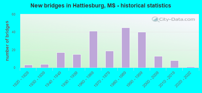
- New bridges - historical statistics
- 31920-1929
- 41930-1939
- 171940-1949
- 151950-1959
- 411960-1969
- 191970-1979
- 451980-1989
- 401990-1999
- 132000-2009
- 82010-2019
- 12020-2022
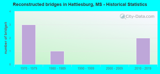
- Reconstructed bridges - Historical Statistics
- 31970-1979
- 11980-1989
- 01990-1999
- 02000-2009
- 22010-2019
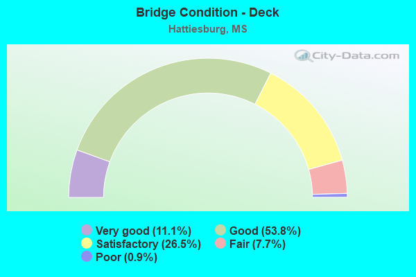
- Bridge Condition - Deck
- 11.1%Very good
- 53.8%Good
- 26.5%Satisfactory
- 7.7%Fair
- 0.9%Poor

- Bridge Condition - Superstructure
- 38.5%Very good
- 32.5%Good
- 21.4%Satisfactory
- 6.0%Fair
- 1.7%Poor
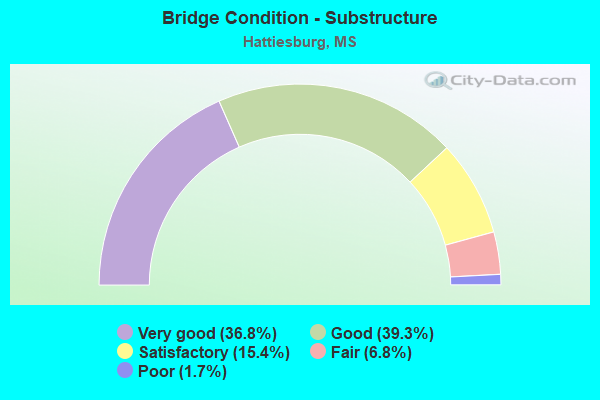
- Bridge Condition - Substructure
- 36.8%Very good
- 39.3%Good
- 15.4%Satisfactory
- 6.8%Fair
- 1.7%Poor
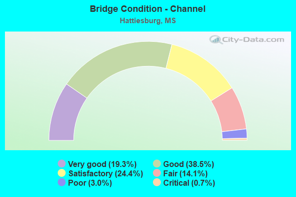
- Bridge Condition - Channel
- 19.3%Very good
- 38.5%Good
- 24.4%Satisfactory
- 14.1%Fair
- 3.0%Poor
- 0.7%Critical
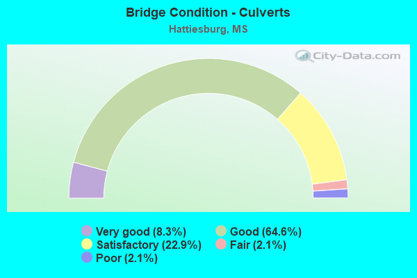
- Bridge Condition - Culverts
- 8.3%Very good
- 64.6%Good
- 22.9%Satisfactory
- 2.1%Fair
- 2.1%Poor
Find on map >> Show street view
Structure Number: 11000590180572A, Location: 3.9 MI N LAMAR CL (Lat: 31.222339, Lng: -89.326069), Route carried "on" structure: Interstate 59, Year Built: 1961, Status: Open, Structure Length: 0.82m (2.69ft), Average Daily Traffic: 10,000 (year 2020), Truck Traffic: 24%, Average Future Daily Traffic: 14,500 (year 2040), Design Load: HS 20, Features Intersected: TOM CREEK
Minimum Vertical Clearance: 30+ m (98+ ft), Kilometerpoint: 17.186, Lanes on structure: 2, Base Highway Network: Yes (Inventory Route: 5, Subroute: 2), Owner: State Highway Agency, Approaching Roadway Width: 14.6m (47.9ft), Skew: 1 degrees, Material/Design: Concrete, Design/Construction: Culvert, Number Of Spans In Main Unit: 2, Length of Maximum Span: 3.7m (12.1ft)
Condition: Channel: Satisfactory, Culverts: Good, Inventory Rating: 56.7 metric tons, Method Used To Determine Inventory Rating: Load Factor (LF), Structural Evaluation: Better than present minimum criteria, Waterway Adequacy: Equal to present desirable criteria, Approach Roadway Alignment: Equal to present desirable criteria, Designated Inspection Frequency: Every 24 months, Inspection Date: December 2020
Find on map >> Show street view
Structure Number: 11000590180572B, Location: 3.9 MI N LAMAR CL (Lat: 31.222200, Lng: -89.325622), Route carried "on" structure: Interstate 59, Year Built: 1961, Status: Open, Structure Length: 0.82m (2.69ft), Average Daily Traffic: 10,000 (year 2020), Truck Traffic: 24%, Average Future Daily Traffic: 11,000 (year 2040), Design Load: HS 20, Features Intersected: TOM CREEK
Minimum Vertical Clearance: 30+ m (98+ ft), Kilometerpoint: 5.753, Lanes on structure: 2, Base Highway Network: Yes (Inventory Route: 5, Subroute: 1), Owner: State Highway Agency, Approaching Roadway Width: 14.6m (47.9ft), Skew: 1 degrees, Material/Design: Concrete, Design/Construction: Culvert, Number Of Spans In Main Unit: 2, Length of Maximum Span: 3.7m (12.1ft)
Condition: Channel: Good, Culverts: Satisfactory, Operating Rating: 80.1 metric tons, Method Used To Determine Operating Rating: Load Factor (LF), Inventory Rating: 47.7 metric tons, Method Used To Determine Inventory Rating: Load Factor (LF), Structural Evaluation: Equal to present minimum criteria, Waterway Adequacy: Equal to present desirable criteria, Approach Roadway Alignment: Equal to present desirable criteria, Designated Inspection Frequency: Every 24 months, Inspection Date: December 2020
Find on map >> Show street view
Structure Number: 11000590180588A, Location: 5.0 MI S LAMAR CL (Lat: 31.244728, Lng: -89.326550), Route carried "on" structure: Interstate 59, Year Built: 1961, Year Reconstructed: 2015, Status: Open, Structure Length: 5.64m (18.50ft), Average Daily Traffic: 10,000 (year 2020), Truck Traffic: 24%, Average Future Daily Traffic: 14,500 (year 2040), Design Load: HS 20+Mod, Features Intersected: STEELE ROAD
Minimum Vertical Clearance: 5.37m (17.62ft), Kilometerpoint: 14.573, Lanes on structure: 2, Lanes under structure: 2, Base Highway Network: Yes (Inventory Route: 5, Subroute: 2), Owner: State Highway Agency, Approaching Roadway Width: 11.6m (38.1ft), Skew: 3 degrees, Material/Design: Prestressed concrete, Design/Construction: Stringer/Multi-beam, Number Of Spans In Main Unit: 1, Number Of Approach Spans: 2, Length of Maximum Span: 21.6m (70.9ft), Curb-To-Curb Width: 12.8m (42.0ft), Out-to-Out Width: 13.7m (44.9ft)
Condition: Deck: Good, Superstructure: Good, Substructure: Good, Inventory Rating: 47.9 metric tons, Method Used To Determine Inventory Rating: Load Factor (LF), Structural Evaluation: Better than present minimum criteria, Deck Geometry: Equal to present desirable criteria, Underclear: High priority of corrective action, Approach Roadway Alignment: Equal to present desirable criteria, Length Of Structure Improvement: 5.64m (18.50ft), Designated Inspection Frequency: Every 24 months, Inspection Date: June 2021, Bridge Improvement Cost: $194,000,000, Roadway Improvement Cost: $130,000,000, Total Project Cost: $324,000,000, Deck Structure Type: Concrete Cast-file-Place
Find on map >> Show street view
Structure Number: 11000590180588B, Location: 5.0 MI S LAMAR CL (Lat: 31.244308, Lng: -89.325942), Route carried "on" structure: Interstate 59, Year Built: 1961, Year Reconstructed: 2015, Status: Open, Structure Length: 5.64m (18.50ft), Average Daily Traffic: 10,000 (year 2020), Truck Traffic: 24%, Average Future Daily Traffic: 14,500 (year 2040), Design Load: HS 20+Mod, Features Intersected: STEELE ROAD
Minimum Vertical Clearance: 30+ m (98+ ft), Kilometerpoint: 8.327, Lanes on structure: 2, Lanes under structure: 2, Base Highway Network: Yes (Inventory Route: 5, Subroute: 1), Owner: State Highway Agency, Approaching Roadway Width: 15.9m (52.2ft), Skew: 3 degrees, Material/Design: Prestressed concrete, Design/Construction: Stringer/Multi-beam, Number Of Spans In Main Unit: 1, Number Of Approach Spans: 2, Length of Maximum Span: 21.6m (70.9ft), Curb-To-Curb Width: 16.8m (55.1ft), Out-to-Out Width: 17.6m (57.7ft)
Condition: Deck: Good, Superstructure: Good, Substructure: Good, Operating Rating: 56.7 metric tons, Method Used To Determine Operating Rating: Load Factor (LF), Inventory Rating: 33.9 metric tons, Method Used To Determine Inventory Rating: Load Factor (LF), Structural Evaluation: Better than present minimum criteria, Deck Geometry: Superior to present desirable criteria, Underclear: High priority of corrective action, Approach Roadway Alignment: Equal to present desirable criteria, Designated Inspection Frequency: Every 24 months, Inspection Date: June 2021, Deck Structure Type: Concrete Cast-file-Place
Find on map >> Show street view
Structure Number: 11000590180612A, Location: LAMAR/FORREST CL (Lat: 31.274044, Lng: -89.347317), Route carried "on" structure: Interstate 59, Year Built: 1960, Status: Open, Structure Length: 6.25m (20.51ft), Average Daily Traffic: 20,500 (year 2020), Truck Traffic: 19%, Average Future Daily Traffic: 28,500 (year 2040), Design Load: HS 20+Mod, Features Intersected: NORFOLK SOUTHERN RR
Minimum Vertical Clearance: 30+ m (98+ ft), Kilometerpoint: 10.767, Lanes on structure: 2, Base Highway Network: Yes (Inventory Route: 5, Subroute: 2), Owner: State Highway Agency, Approaching Roadway Width: 12.8m (42.0ft), Skew: 3 degrees, Material/Design: Concrete, Design/Construction: Slab, Number Of Spans In Main Unit: 5, Length of Maximum Span: 12.5m (41.0ft), Curb-To-Curb Width: 8.5m (27.9ft), Out-to-Out Width: 10.0m (32.8ft)
Condition: Deck: Satisfactory, Superstructure: Satisfactory, Substructure: Good, Operating Rating: 71.9 metric tons, Method Used To Determine Operating Rating: Load Factor (LF), Inventory Rating: 43.0 metric tons, Method Used To Determine Inventory Rating: Load Factor (LF), Structural Evaluation: Equal to present minimum criteria, Deck Geometry: High priority of corrective action, Underclear: Somewhat better than minimum adequacy, Approach Roadway Alignment: Equal to present desirable criteria, Length Of Structure Improvement: 8.04m (26.38ft), Designated Inspection Frequency: Every 24 months, Inspection Date: December 2020, Bridge Improvement Cost: $739,000,000, Roadway Improvement Cost: $74,000,000, Total Project Cost: $999,999,000, Deck Structure Type: Concrete Cast-file-Place
Find on map >> Show street view
Structure Number: 11000590180612B, Location: LAMAR/FORREST CL (Lat: 31.273850, Lng: -89.346869), Route carried "on" structure: Interstate 59, Year Built: 1960, Status: Open, Structure Length: 6.25m (20.51ft), Average Daily Traffic: 20,500 (year 2020), Truck Traffic: 19%, Average Future Daily Traffic: 28,500 (year 2040), Design Load: HS 20+Mod, Features Intersected: NORFOLK SOUTHERN RR
Minimum Vertical Clearance: 30+ m (98+ ft), Kilometerpoint: 12.160, Lanes on structure: 2, Base Highway Network: Yes (Inventory Route: 5, Subroute: 1), Owner: State Highway Agency, Approaching Roadway Width: 12.8m (42.0ft), Skew: 3 degrees, Material/Design: Concrete, Design/Construction: Slab, Number Of Spans In Main Unit: 5, Length of Maximum Span: 12.5m (41.0ft), Curb-To-Curb Width: 8.5m (27.9ft), Out-to-Out Width: 10.0m (32.8ft)
Condition: Deck: Fair, Superstructure: Fair, Substructure: Good, Operating Rating: 71.9 metric tons, Method Used To Determine Operating Rating: Load Factor (LF), Inventory Rating: 43.0 metric tons, Method Used To Determine Inventory Rating: Load Factor (LF), Structural Evaluation: Somewhat better than minimum adequacy, Deck Geometry: High priority of corrective action, Underclear: Somewhat better than minimum adequacy, Approach Roadway Alignment: Equal to present desirable criteria, Length Of Structure Improvement: 8.04m (26.38ft), Designated Inspection Frequency: Every 24 months, Inspection Date: December 2020, Bridge Improvement Cost: $739,000,000, Roadway Improvement Cost: $74,000,000, Total Project Cost: $999,999,000, Deck Structure Type: Concrete Cast-file-Place
Find on map >> Show street view
Structure Number: 11000590180668A, Location: I 59 OVER US 49 (Lat: 31.357167, Lng: -89.346347), Route carried "on" structure: Interstate 59, Year Built: 1960, Status: Open, Structure Length: 6.98m (22.90ft), Average Daily Traffic: 25,000 (year 2020), Truck Traffic: 17%, Average Future Daily Traffic: 35,000 (year 2040), Design Load: HS 20+Mod, Features Intersected: US 49
Minimum Vertical Clearance: 30+ m (98+ ft), Kilometerpoint: 9.352, Lanes on structure: 2, Lanes under structure: 6, Base Highway Network: Yes (Inventory Route: 5, Subroute: 1), Owner: State Highway Agency, Approaching Roadway Width: 15.8m (51.8ft), Material/Design: Concrete continuous, Design/Construction: Box Beam or Girders - Single/Spread, Number Of Spans In Main Unit: 2, Number Of Approach Spans: 2, Length of Maximum Span: 20.4m (66.9ft), Curb-To-Curb Width: 11.6m (38.1ft), Out-to-Out Width: 13.0m (42.7ft)
Condition: Deck: Satisfactory, Superstructure: Satisfactory, Substructure: Good, Operating Rating: 63.5 metric tons, Method Used To Determine Operating Rating: Load Factor (LF), Inventory Rating: 38.2 metric tons, Method Used To Determine Inventory Rating: Load Factor (LF), Structural Evaluation: Equal to present minimum criteria, Deck Geometry: Equal to present minimum criteria, Underclear: Equal to present minimum criteria, Approach Roadway Alignment: Equal to present desirable criteria, Length Of Structure Improvement: 6.98m (22.90ft), Designated Inspection Frequency: Every 24 months, Inspection Date: December 2020, Bridge Improvement Cost: $240,000,000, Roadway Improvement Cost: $130,000,000, Total Project Cost: $370,000,000, Deck Structure Type: Concrete Cast-file-Place
Find on map >> Show street view
Structure Number: 11000590180668B, Location: I 59 OVER US 49 (Lat: 31.356497, Lng: -89.346592), Route carried "on" structure: Interstate 59, Year Built: 1960, Status: Open, Structure Length: 6.98m (22.90ft), Average Daily Traffic: 25,000 (year 2020), Truck Traffic: 17%, Average Future Daily Traffic: 35,000 (year 2040), Design Load: HS 20+Mod, Features Intersected: US 49
Minimum Vertical Clearance: 30+ m (98+ ft), Kilometerpoint: 13.568, Lanes on structure: 2, Lanes under structure: 6, Base Highway Network: Yes (Inventory Route: 5, Subroute: 2), Owner: State Highway Agency, Approaching Roadway Width: 15.8m (51.8ft), Material/Design: Concrete continuous, Design/Construction: Box Beam or Girders - Single/Spread, Number Of Spans In Main Unit: 2, Number Of Approach Spans: 2, Length of Maximum Span: 20.4m (66.9ft), Curb-To-Curb Width: 11.6m (38.1ft), Out-to-Out Width: 13.0m (42.7ft)
Condition: Deck: Satisfactory, Superstructure: Satisfactory, Substructure: Good, Operating Rating: 63.5 metric tons, Method Used To Determine Operating Rating: Load Factor (LF), Inventory Rating: 38.2 metric tons, Method Used To Determine Inventory Rating: Load Factor (LF), Structural Evaluation: Equal to present minimum criteria, Deck Geometry: Equal to present minimum criteria, Underclear: Equal to present minimum criteria, Approach Roadway Alignment: Equal to present desirable criteria, Length Of Structure Improvement: 6.98m (22.90ft), Designated Inspection Frequency: Every 24 months, Inspection Date: December 2020, Bridge Improvement Cost: $240,000,000, Roadway Improvement Cost: $130,000,000, Total Project Cost: $370,000,000, Deck Structure Type: Concrete Cast-file-Place
Find on map >> Show street view
Structure Number: 11000590180671A, Location: 0.2 MI N US 49 (Lat: 31.360142, Lng: -89.343592), Route carried "on" structure: Interstate 59, Year Built: 1960, Status: Open, Structure Length: 4.57m (14.99ft), Average Daily Traffic: 21,000 (year 2020), Truck Traffic: 15%, Average Future Daily Traffic: 30,000 (year 2040), Design Load: HS 20+Mod, Features Intersected: CNIC RR
Minimum Vertical Clearance: 30+ m (98+ ft), Kilometerpoint: 8.930, Lanes on structure: 2, Base Highway Network: Yes (Inventory Route: 5, Subroute: 1), Owner: State Highway Agency, Approaching Roadway Width: 15.2m (49.9ft), Material/Design: Concrete, Design/Construction: Slab, Number Of Spans In Main Unit: 5, Length of Maximum Span: 9.1m (29.9ft), Curb-To-Curb Width: 11.6m (38.1ft), Out-to-Out Width: 13.0m (42.7ft)
Condition: Deck: Satisfactory, Superstructure: Satisfactory, Substructure: Good, Operating Rating: 57.3 metric tons, Method Used To Determine Operating Rating: Load Factor (LF), Inventory Rating: 34.3 metric tons, Method Used To Determine Inventory Rating: Load Factor (LF), Structural Evaluation: Equal to present minimum criteria, Deck Geometry: Equal to present minimum criteria, Underclear: Somewhat better than minimum adequacy, Approach Roadway Alignment: Equal to present desirable criteria, Length Of Structure Improvement: 4.57m (14.99ft), Designated Inspection Frequency: Every 24 months, Inspection Date: December 2020, Bridge Improvement Cost: $153,000,000, Roadway Improvement Cost: $130,000,000, Total Project Cost: $300,000,000, Deck Structure Type: Concrete Cast-file-Place
Find on map >> Show street view
Structure Number: 11000590180671B, Location: 0.2 MI N US 49 (Lat: 31.359731, Lng: -89.343628), Route carried "on" structure: Interstate 59, Year Built: 1960, Status: Open, Structure Length: 4.57m (14.99ft), Average Daily Traffic: 21,000 (year 2020), Truck Traffic: 15%, Average Future Daily Traffic: 30,000 (year 2040), Design Load: HS 20+Mod, Features Intersected: CNIC RR
Minimum Vertical Clearance: 30+ m (98+ ft), Kilometerpoint: 14.025, Lanes on structure: 2, Base Highway Network: Yes (Inventory Route: 5, Subroute: 2), Owner: State Highway Agency, Approaching Roadway Width: 17.7m (58.1ft), Material/Design: Concrete, Design/Construction: Slab, Number Of Spans In Main Unit: 5, Length of Maximum Span: 9.1m (29.9ft), Curb-To-Curb Width: 12.8m (42.0ft), Out-to-Out Width: 14.3m (46.9ft)
Condition: Deck: Fair, Superstructure: Fair, Substructure: Good, Operating Rating: 57.7 metric tons, Method Used To Determine Operating Rating: Load Factor (LF), Inventory Rating: 34.5 metric tons, Method Used To Determine Inventory Rating: Load Factor (LF), Structural Evaluation: Somewhat better than minimum adequacy, Deck Geometry: Equal to present desirable criteria, Underclear: Somewhat better than minimum adequacy, Approach Roadway Alignment: Equal to present desirable criteria, Length Of Structure Improvement: 4.57m (14.99ft), Designated Inspection Frequency: Every 24 months, Inspection Date: December 2020, Bridge Improvement Cost: $153,000,000, Roadway Improvement Cost: $130,000,000, Total Project Cost: $300,000,000, Deck Structure Type: Concrete Cast-file-Place
Find on map >> Show street view
Structure Number: 11000590180677A, Location: 0.8 MI N US 49 (Lat: 31.369242, Lng: -89.335222), Route carried "on" structure: Interstate 59, Year Built: 1960, Status: Open, Structure Length: 32.92m (108.01ft), Average Daily Traffic: 21,000 (year 2020), Truck Traffic: 15%, Average Future Daily Traffic: 30,000 (year 2040), Design Load: HS 20+Mod, Features Intersected: BOUIE RIVER
Minimum Vertical Clearance: 30+ m (98+ ft), Kilometerpoint: 7.644, Lanes on structure: 2, Base Highway Network: Yes (Inventory Route: 5, Subroute: 1), Owner: State Highway Agency, Approaching Roadway Width: 13.4m (44.0ft), Material/Design: Steel continuous, Design/Construction: Stringer/Multi-beam, Number Of Spans In Main Unit: 3, Number Of Approach Spans: 19, Length of Maximum Span: 36.6m (120.1ft), Curb-To-Curb Width: 8.5m (27.9ft), Out-to-Out Width: 10.0m (32.8ft)
Condition: Deck: Fair, Superstructure: Fair, Substructure: Satisfactory, Channel: Fair, Operating Rating: 55.1 metric tons, Method Used To Determine Operating Rating: Load Factor (LF), Inventory Rating: 32.9 metric tons, Method Used To Determine Inventory Rating: Load Factor (LF), Structural Evaluation: Somewhat better than minimum adequacy, Deck Geometry: High priority of corrective action, Waterway Adequacy: Equal to present desirable criteria, Approach Roadway Alignment: Equal to present desirable criteria, Length Of Structure Improvement: 38.55m (126.48ft), Designated Inspection Frequency: Every 24 months, Underwater Inspection Frequency: Every 60 months, Inspection Date: December 2020, Underwater Inspection Date: May 2019, Bridge Improvement Cost: $999,999,000, Roadway Improvement Cost: $399,000,000, Total Project Cost: $999,999,000, Deck Structure Type: Concrete Cast-file-Place
Find on map >> Show street view
Structure Number: 11000590180677B, Location: 0.8 MI N US 49 (Lat: 31.366778, Lng: -89.337150), Route carried "on" structure: Interstate 59, Year Built: 1960, Status: Open, Structure Length: 32.92m (108.01ft), Average Daily Traffic: 21,000 (year 2020), Truck Traffic: 15%, Average Future Daily Traffic: 30,000 (year 2040), Design Load: HS 20+Mod, Features Intersected: BOUIE RIVER
Minimum Vertical Clearance: 30+ m (98+ ft), Kilometerpoint: 15.020, Lanes on structure: 2, Base Highway Network: Yes (Inventory Route: 5, Subroute: 2), Owner: State Highway Agency, Approaching Roadway Width: 12.8m (42.0ft), Material/Design: Steel continuous, Design/Construction: Stringer/Multi-beam, Number Of Spans In Main Unit: 3, Number Of Approach Spans: 19, Length of Maximum Span: 36.6m (120.1ft), Curb-To-Curb Width: 8.5m (27.9ft), Out-to-Out Width: 10.0m (32.8ft)
Condition: Deck: Fair, Superstructure: Satisfactory, Substructure: Fair, Channel: Poor, Operating Rating: 55.1 metric tons, Method Used To Determine Operating Rating: Load Factor (LF), Inventory Rating: 32.9 metric tons, Method Used To Determine Inventory Rating: Load Factor (LF), Structural Evaluation: Somewhat better than minimum adequacy, Deck Geometry: High priority of corrective action, Waterway Adequacy: Equal to present desirable criteria, Approach Roadway Alignment: Equal to present desirable criteria, Length Of Structure Improvement: 38.55m (126.48ft), Designated Inspection Frequency: Every 24 months, Underwater Inspection Frequency: Every 60 months, Inspection Date: December 2020, Underwater Inspection Date: May 2019, Bridge Improvement Cost: $999,999,000, Roadway Improvement Cost: $399,000,000, Total Project Cost: $999,999,000, Deck Structure Type: Concrete Cast-file-Place
Find on map >> Show street view
Structure Number: 11000590370662, Location: LAMAR/FORREST CL (Lat: 31.346403, Lng: -89.351989), Route carried "on" structure: Interstate 59, Year Built: 1960, Status: Open, Structure Length: 1.19m (3.90ft), Average Daily Traffic: 50,000 (year 2020), Truck Traffic: 17%, Average Future Daily Traffic: 70,000 (year 2040), Design Load: HS 20, Features Intersected: MIXONS CREEK
Minimum Vertical Clearance: 30+ m (98+ ft), Kilometerpoint: 28.009, Lanes on structure: 4, Base Highway Network: Yes (Inventory Route: 5, Subroute: 3), Owner: State Highway Agency, Approaching Roadway Width: 38.1m (125.0ft), Material/Design: Concrete, Design/Construction: Culvert, Number Of Spans In Main Unit: 2, Length of Maximum Span: 5.5m (18.0ft)
Condition: Channel: Satisfactory, Culverts: Good, Structural Evaluation: Better than present minimum criteria, Waterway Adequacy: Equal to present desirable criteria, Approach Roadway Alignment: Equal to present desirable criteria, Length Of Structure Improvement: 1.19m (3.90ft), Designated Inspection Frequency: Every 24 months, Inspection Date: December 2020, Bridge Improvement Cost: $176,000,000, Roadway Improvement Cost: $200,000,000, Total Project Cost: $376,000,000
Find on map >> Show street view
Structure Number: 17000590180588, Location: 5.0 MI S LAMAR CL (Lat: 31.244753, Lng: -89.326883), Route carried "on" structure: Ramp Interstate 59, Year Built: 1980, Status: Open, Structure Length: 5.55m (18.21ft), Average Daily Traffic: 13,000 (year 2020), Truck Traffic: 7%, Average Future Daily Traffic: 13,000 (year 2040), Design Load: HS 20, Features Intersected: STEELE ROAD
Minimum Vertical Clearance: 30+ m (98+ ft), Kilometerpoint: 0.447, Lanes on structure: 1, Lanes under structure: 2, Owner: State Highway Agency, Approaching Roadway Width: 12.8m (42.0ft), Skew: 2 degrees, Material/Design: Prestressed concrete continuous, Design/Construction: Stringer/Multi-beam, Number Of Spans In Main Unit: 1, Number Of Approach Spans: 2, Length of Maximum Span: 20.1m (65.9ft), Curb-To-Curb Width: 8.5m (27.9ft), Out-to-Out Width: 9.4m (30.8ft)
Condition: Deck: Good, Superstructure: Very good, Substructure: Very good, Operating Rating: 59.9 metric tons, Method Used To Determine Operating Rating: Load Factor (LF), Inventory Rating: 26.7 metric tons, Method Used To Determine Inventory Rating: Load Factor (LF), Structural Evaluation: Equal to present minimum criteria, Deck Geometry: Superior to present desirable criteria, Underclear: Meets minimum limits, Approach Roadway Alignment: Equal to present desirable criteria, Designated Inspection Frequency: Every 24 months, Inspection Date: December 2020, Deck Structure Type: Concrete Cast-file-Place
Find on map >> Show street view
Structure Number: 21000110180689A, Location: US 11 OVER I 59 (Lat: 31.260878, Lng: -89.337428), Route carried "on" structure: US 11, Year Built: 1960, Status: Open, Structure Length: 9.75m (31.99ft), Average Daily Traffic: 3,350 (year 2020), Truck Traffic: 9%, Average Future Daily Traffic: 3,350 (year 2040), Design Load: HS 20, Features Intersected: I 59
Minimum Vertical Clearance: 30+ m (98+ ft), Kilometerpoint: 6.400, Lanes on structure: 2, Lanes under structure: 4, Owner: State Highway Agency, Approaching Roadway Width: 13.4m (44.0ft), Material/Design: Concrete continuous, Design/Construction: Box Beam or Girders - Single/Spread, Number Of Spans In Main Unit: 2, Number Of Approach Spans: 3, Length of Maximum Span: 23.5m (77.1ft), Curb-To-Curb Width: 8.5m (27.9ft), Out-to-Out Width: 10.0m (32.8ft)
Condition: Deck: Good, Superstructure: Good, Substructure: Good, Operating Rating: 45.5 metric tons, Method Used To Determine Operating Rating: Load Factor (LF), Inventory Rating: 27.3 metric tons, Method Used To Determine Inventory Rating: Load Factor (LF), Structural Evaluation: Equal to present minimum criteria, Deck Geometry: High priority of corrective action, Underclear: Meets minimum limits, Approach Roadway Alignment: Equal to present desirable criteria, Length Of Structure Improvement: 9.75m (31.99ft), Designated Inspection Frequency: Every 24 months, Inspection Date: Febuary 2020, Bridge Improvement Cost: $496,000,000, Roadway Improvement Cost: $130,000,000, Total Project Cost: $626,000,000, Deck Structure Type: Concrete Cast-file-Place
Find on map >> Show street view
Structure Number: 21000110180689B, Location: US 11 OVER I 59 (Lat: 31.259703, Lng: -89.337436), Route carried "on" structure: US 11, Year Built: 1960, Status: Open, Structure Length: 9.75m (31.99ft), Average Daily Traffic: 3,350 (year 2020), Truck Traffic: 9%, Average Future Daily Traffic: 3,350 (year 2040), Design Load: HS 20, Features Intersected: I 59
Minimum Vertical Clearance: 30+ m (98+ ft), Kilometerpoint: 2.316, Lanes on structure: 2, Lanes under structure: 4, Owner: State Highway Agency, Approaching Roadway Width: 12.8m (42.0ft), Material/Design: Concrete continuous, Design/Construction: Box Beam or Girders - Single/Spread, Number Of Spans In Main Unit: 2, Number Of Approach Spans: 3, Length of Maximum Span: 23.5m (77.1ft), Curb-To-Curb Width: 8.5m (27.9ft), Out-to-Out Width: 10.0m (32.8ft)
Condition: Deck: Good, Superstructure: Good, Substructure: Very good, Operating Rating: 45.5 metric tons, Method Used To Determine Operating Rating: Load Factor (LF), Inventory Rating: 27.3 metric tons, Method Used To Determine Inventory Rating: Load Factor (LF), Structural Evaluation: Equal to present minimum criteria, Deck Geometry: High priority of corrective action, Underclear: Meets minimum limits, Approach Roadway Alignment: Equal to present desirable criteria, Length Of Structure Improvement: 9.75m (31.99ft), Designated Inspection Frequency: Every 24 months, Inspection Date: Febuary 2020, Bridge Improvement Cost: $496,000,000, Roadway Improvement Cost: $130,000,000, Total Project Cost: $626,000,000, Deck Structure Type: Concrete Cast-file-Place
Find on map >> Show street view
Structure Number: 21000110180723, Location: 0.3 MI S US 49 (Lat: 31.304047, Lng: -89.320328), Route carried "on" structure: US 11, Year Built: 1953, Status: Open, Structure Length: 0.79m (2.59ft), Average Daily Traffic: 13,000 (year 2020), Truck Traffic: 6%, Average Future Daily Traffic: 13,000 (year 2040), Design Load: H 15, Features Intersected: STREAM
Minimum Vertical Clearance: 30+ m (98+ ft), Kilometerpoint: 7.689, Lanes on structure: 2, Owner: State Highway Agency, Approaching Roadway Width: 15.2m (49.9ft), Material/Design: Concrete, Design/Construction: Culvert, Number Of Spans In Main Unit: 2, Length of Maximum Span: 2.7m (8.9ft)
Condition: Channel: Good, Culverts: Good, Operating Rating: 52.7 metric tons, Method Used To Determine Operating Rating: Load Factor (LF), Inventory Rating: 31.5 metric tons, Method Used To Determine Inventory Rating: Load Factor (LF), Structural Evaluation: Better than present minimum criteria, Waterway Adequacy: Better than present minimum criteria, Approach Roadway Alignment: Equal to present desirable criteria, Length Of Structure Improvement: 0.79m (2.59ft), Designated Inspection Frequency: Every 24 months, Inspection Date: Febuary 2020, Bridge Improvement Cost: $50,000,000, Roadway Improvement Cost: $200,000,000, Total Project Cost: $250,000,000
Find on map >> Show street view
Structure Number: 21000110180724, Location: 0.1 MI S US 49 (Lat: 31.305533, Lng: -89.318581), Route carried "on" structure: US 11, Year Built: 1953, Status: Open, Structure Length: 0.84m (2.76ft), Average Daily Traffic: 21,000 (year 2020), Truck Traffic: 3%, Average Future Daily Traffic: 21,000 (year 2040), Design Load: H 15, Features Intersected: GORDONS CREEK
Minimum Vertical Clearance: 30+ m (98+ ft), Kilometerpoint: 7.928, Lanes on structure: 2, Owner: State Highway Agency, Approaching Roadway Width: 45.1m (148.0ft), Material/Design: Concrete, Design/Construction: Culvert, Number Of Spans In Main Unit: 2, Length of Maximum Span: 4.2m (13.8ft)
Condition: Channel: Satisfactory, Culverts: Good, Operating Rating: 42.4 metric tons, Method Used To Determine Operating Rating: Load Factor (LF), Inventory Rating: 25.4 metric tons, Method Used To Determine Inventory Rating: Load Factor (LF), Structural Evaluation: Equal to present minimum criteria, Waterway Adequacy: Better than present minimum criteria, Approach Roadway Alignment: Better than present minimum criteria, Designated Inspection Frequency: Every 24 months, Inspection Date: Febuary 2020
Find on map >> Show street view
Structure Number: 2100011018073, Location: 0.2 MI N US 49 (Lat: 31.311589, Lng: -89.311722), Route carried "on" structure: US 11, Year Built: 1938, Year Reconstructed: 1982, Status: Open, Structure Length: 1.19m (3.90ft), Average Daily Traffic: 16,000 (year 2020), Truck Traffic: 3%, Average Future Daily Traffic: 16,000 (year 2040), Design Load: H 15, Features Intersected: GORDONS CREEK
Minimum Vertical Clearance: 30+ m (98+ ft), Kilometerpoint: 8.866, Lanes on structure: 2, Base Highway Network: Yes (Inventory Route: 1, Subroute: 1), Owner: State Highway Agency, Approaching Roadway Width: 21.9m (71.9ft), Material/Design: Concrete, Design/Construction: Culvert, Number Of Spans In Main Unit: 3, Length of Maximum Span: 3.7m (12.1ft)
Condition: Channel: Good, Culverts: Good, Operating Rating: 56.7 metric tons, Method Used To Determine Operating Rating: Load Factor (LF), Inventory Rating: 33.9 metric tons, Method Used To Determine Inventory Rating: Load Factor (LF), Structural Evaluation: Better than present minimum criteria, Waterway Adequacy: Equal to present desirable criteria, Approach Roadway Alignment: Equal to present desirable criteria, Designated Inspection Frequency: Every 24 months, Inspection Date: Febuary 2020
Find on map >> Show street view
Structure Number: 21000490180570B, Location: 14.9 MI N SR 13 (Lat: 31.157419, Lng: -89.238906), Route carried "on" structure: US 49, Year Built: 1959, Status: Open, Structure Length: 3.66m (12.01ft), Average Daily Traffic: 8,500 (year 2020), Truck Traffic: 13%, Average Future Daily Traffic: 9,500 (year 2040), Design Load: HS 20, Features Intersected: MORRIS BRANCH
Minimum Vertical Clearance: 30+ m (98+ ft), Kilometerpoint: 28.481, Lanes on structure: 2, Base Highway Network: Yes (Inventory Route: 4, Subroute: 1), Owner: State Highway Agency, Approaching Roadway Width: 13.4m (44.0ft), Material/Design: Concrete, Design/Construction: Slab, Number Of Spans In Main Unit: 6, Length of Maximum Span: 6.1m (20.0ft), Curb-To-Curb Width: 8.5m (27.9ft), Out-to-Out Width: 10.0m (32.8ft)
Condition: Deck: Good, Superstructure: Good, Substructure: Good, Channel: Satisfactory, Operating Rating: 64.3 metric tons, Method Used To Determine Operating Rating: Load Factor (LF), Inventory Rating: 38.5 metric tons, Method Used To Determine Inventory Rating: Load Factor (LF), Structural Evaluation: Better than present minimum criteria, Deck Geometry: High priority of corrective action, Waterway Adequacy: Equal to present desirable criteria, Approach Roadway Alignment: Equal to present desirable criteria, Length Of Structure Improvement: 4.75m (15.58ft), Designated Inspection Frequency: Every 24 months, Inspection Date: Febuary 2020, Bridge Improvement Cost: $392,000,000, Roadway Improvement Cost: $39,000,000, Total Project Cost: $999,999,000, Deck Structure Type: Concrete Cast-file-Place
Find on map >> Show street view
Structure Number: 21000490180571A, Location: 6.4 MI S US 98 (Lat: 31.157522, Lng: -89.239378), Route carried "on" structure: US 49, Year Built: 2018, Status: Open, Structure Length: 4.65m (15.26ft), Average Daily Traffic: 8,500 (year 2020), Truck Traffic: 13%, Average Future Daily Traffic: 8,500 (year 2040), Design Load: HL 93, Features Intersected: MORRIS BRANCH
Minimum Vertical Clearance: 30+ m (98+ ft), Kilometerpoint: 33.117, Lanes on structure: 2, Base Highway Network: Yes (Inventory Route: 4, Subroute: 4), Owner: State Highway Agency, Approaching Roadway Width: 12.2m (40.0ft), Skew: 3 degrees, Material/Design: Prestressed concrete continuous, Design/Construction: Stringer/Multi-beam, Number Of Spans In Main Unit: 3, Length of Maximum Span: 15.2m (49.9ft), Curb-To-Curb Width: 12.2m (40.0ft), Out-to-Out Width: 13.0m (42.7ft)
Condition: Deck: Very good, Superstructure: Very good, Substructure: Very good, Channel: Very good, Operating Rating: 63.5 metric tons, Method Used To Determine Operating Rating: Load and Resistance Factor (LRFR), Inventory Rating: 49.0 metric tons, Method Used To Determine Inventory Rating: Load and Resistance Factor (LRFR), Structural Evaluation: Equal to present desirable criteria, Deck Geometry: Better than present minimum criteria, Waterway Adequacy: Superior to present desirable criteria, Approach Roadway Alignment: Equal to present desirable criteria, Designated Inspection Frequency: Every 24 months, Inspection Date: Febuary 2020, Deck Structure Type: Concrete Cast-file-Place
Find on map >> Show street view
Structure Number: 21000490180626A, Location: 0.9 MI S US 98 (Lat: 31.232283, Lng: -89.270817), Route carried "on" structure: US 49, Year Built: 2009, Status: Open, Structure Length: 3.71m (12.17ft), Average Daily Traffic: 8,500 (year 2020), Truck Traffic: 13%, Average Future Daily Traffic: 8,500 (year 2040), Design Load: HS 20, Features Intersected: MYERS CREEK
Minimum Vertical Clearance: 30+ m (98+ ft), Kilometerpoint: 24.304, Lanes on structure: 2, Base Highway Network: Yes (Inventory Route: 4, Subroute: 4), Owner: State Highway Agency, Approaching Roadway Width: 14.0m (45.9ft), Skew: 1 degrees, Material/Design: Prestressed concrete continuous, Design/Construction: Stringer/Multi-beam, Number Of Spans In Main Unit: 3, Length of Maximum Span: 12.2m (40.0ft), Curb-To-Curb Width: 14.0m (45.9ft), Out-to-Out Width: 14.9m (48.9ft)
Condition: Deck: Good, Superstructure: Very good, Substructure: Very good, Channel: Very good, Operating Rating: 69.7 metric tons, Method Used To Determine Operating Rating: Load Factor (LF), Inventory Rating: 41.7 metric tons, Method Used To Determine Inventory Rating: Load Factor (LF), Structural Evaluation: Equal to present desirable criteria, Deck Geometry: Superior to present desirable criteria, Waterway Adequacy: Equal to present desirable criteria, Approach Roadway Alignment: Equal to present desirable criteria, Designated Inspection Frequency: Every 24 months, Inspection Date: Febuary 2020, Deck Structure Type: Concrete Cast-file-Place
Find on map >> Show street view
Structure Number: 21000490180626B, Location: 0.9 MI S US 98 (Lat: 31.232156, Lng: -89.270333), Route carried "on" structure: US 49, Year Built: 2010, Status: Open, Structure Length: 4.93m (16.17ft), Average Daily Traffic: 8,500 (year 2020), Truck Traffic: 13%, Average Future Daily Traffic: 8,500 (year 2040), Design Load: HS 20, Features Intersected: MYERS CREEK
Minimum Vertical Clearance: 30+ m (98+ ft), Kilometerpoint: 37.289, Lanes on structure: 2, Base Highway Network: Yes (Inventory Route: 4, Subroute: 1), Owner: State Highway Agency, Approaching Roadway Width: 14.0m (45.9ft), Material/Design: Prestressed concrete continuous, Design/Construction: Stringer/Multi-beam, Number Of Spans In Main Unit: 4, Length of Maximum Span: 12.2m (40.0ft), Curb-To-Curb Width: 14.0m (45.9ft), Out-to-Out Width: 14.9m (48.9ft)
Condition: Deck: Good, Superstructure: Very good, Substructure: Very good, Channel: Very good, Operating Rating: 64.0 metric tons, Method Used To Determine Operating Rating: Load Factor (LF), Inventory Rating: 34.6 metric tons, Method Used To Determine Inventory Rating: Load Factor (LF), Structural Evaluation: Equal to present desirable criteria, Deck Geometry: Superior to present desirable criteria, Waterway Adequacy: Equal to present desirable criteria, Approach Roadway Alignment: Equal to present desirable criteria, Designated Inspection Frequency: Every 24 months, Inspection Date: Febuary 2020, Deck Structure Type: Concrete Cast-file-Place
Find on map >> Show street view
Structure Number: 2100049018063, Location: 0.2 MI S US 98 (Lat: 31.239175, Lng: -89.273272), Route carried "on" structure: US 49, Year Built: 1980, Status: Open, Structure Length: 0.64m (2.10ft), Average Daily Traffic: 17,000 (year 2020), Truck Traffic: 13%, Average Future Daily Traffic: 17,000 (year 2040), Design Load: HS 20, Features Intersected: SWAMP
Minimum Vertical Clearance: 30+ m (98+ ft), Kilometerpoint: 38.116, Lanes on structure: 4, Base Highway Network: Yes (Inventory Route: 4, Subroute: 1), Owner: State Highway Agency, Approaching Roadway Width: 51.8m (169.9ft), Material/Design: Concrete, Design/Construction: Culvert, Number Of Spans In Main Unit: 2, Length of Maximum Span: 3.0m (9.8ft)
Condition: Channel: Satisfactory, Culverts: Good, Inventory Rating: 72.0 metric tons, Method Used To Determine Inventory Rating: Load Factor (LF), Structural Evaluation: Better than present minimum criteria, Waterway Adequacy: Equal to present desirable criteria, Approach Roadway Alignment: Equal to present desirable criteria, Length Of Structure Improvement: 0.64m (2.10ft), Designated Inspection Frequency: Every 24 months, Inspection Date: Febuary 2020, Bridge Improvement Cost: $80,000,000, Roadway Improvement Cost: $200,000,000, Total Project Cost: $325,000,000
Find on map >> Show street view
Structure Number: 21000490180633A, Location: US 49 OVER US 98 (Lat: 31.245083, Lng: -89.276175), Route carried "on" structure: US 49, Year Built: 1983, Status: Open, Structure Length: 10.85m (35.60ft), Average Daily Traffic: 8,500 (year 2020), Truck Traffic: 13%, Average Future Daily Traffic: 8,500 (year 2040), Design Load: HS 20, Features Intersected: US 98
Minimum Vertical Clearance: 30+ m (98+ ft), Kilometerpoint: 22.795, Lanes on structure: 2, Lanes under structure: 6, Base Highway Network: Yes (Inventory Route: 4, Subroute: 4), Owner: State Highway Agency, Approaching Roadway Width: 15.8m (51.8ft), Material/Design: Prestressed concrete, Design/Construction: Stringer/Multi-beam, Number Of Spans In Main Unit: 2, Number Of Approach Spans: 2, Length of Maximum Span: 34.4m (112.9ft), Curb-To-Curb Width: 14.4m (47.2ft), Out-to-Out Width: 15.0m (49.2ft)
Condition: Deck: Satisfactory, Superstructure: Very good, Substructure: Very good, Operating Rating: 52.7 metric tons, Method Used To Determine Operating Rating: Load Factor (LF), Inventory Rating: 26.5 metric tons, Method Used To Determine Inventory Rating: Load Factor (LF), Structural Evaluation: Equal to present minimum criteria, Deck Geometry: Superior to present desirable criteria, Underclear: Better than present minimum criteria, Approach Roadway Alignment: Equal to present desirable criteria, Designated Inspection Frequency: Every 24 months, Inspection Date: Febuary 2020, Deck Structure Type: Concrete Cast-file-Place
Find on map >> Show street view
Structure Number: 21000490180633B, Location: US 49 OVER US 98 (Lat: 31.244303, Lng: -89.275414), Route carried "on" structure: US 49, Year Built: 1983, Status: Open, Structure Length: 10.85m (35.60ft), Average Daily Traffic: 8,500 (year 2020), Truck Traffic: 13%, Average Future Daily Traffic: 8,500 (year 2040), Design Load: HS 20, Features Intersected: US 98
Minimum Vertical Clearance: 30+ m (98+ ft), Kilometerpoint: 38.719, Lanes on structure: 2, Lanes under structure: 6, Base Highway Network: Yes (Inventory Route: 4, Subroute: 1), Owner: State Highway Agency, Approaching Roadway Width: 15.8m (51.8ft), Material/Design: Prestressed concrete, Design/Construction: Stringer/Multi-beam, Number Of Spans In Main Unit: 2, Number Of Approach Spans: 2, Length of Maximum Span: 34.4m (112.9ft), Curb-To-Curb Width: 14.4m (47.2ft), Out-to-Out Width: 15.0m (49.2ft)
Condition: Deck: Good, Superstructure: Very good, Substructure: Very good, Operating Rating: 54.1 metric tons, Method Used To Determine Operating Rating: Load Factor (LF), Inventory Rating: 26.2 metric tons, Method Used To Determine Inventory Rating: Load Factor (LF), Structural Evaluation: Equal to present minimum criteria, Deck Geometry: Superior to present desirable criteria, Underclear: Better than present minimum criteria, Approach Roadway Alignment: Equal to present desirable criteria, Designated Inspection Frequency: Every 24 months, Inspection Date: Febuary 2020, Deck Structure Type: Concrete Cast-file-Place
Find on map >> Show street view
Structure Number: 21000490180653A, Location: 1.9 MI N US 98 (Lat: 31.270814, Lng: -89.286842), Route carried "on" structure: US 49, Year Built: 1996, Status: Open, Structure Length: 4.63m (15.19ft), Average Daily Traffic: 6,500 (year 2020), Truck Traffic: 11%, Average Future Daily Traffic: 6,500 (year 2040), Design Load: HS 20, Features Intersected: PRIEST CREEK
Minimum Vertical Clearance: 30+ m (98+ ft), Kilometerpoint: 19.768, Lanes on structure: 2, Base Highway Network: Yes (Inventory Route: 4, Subroute: 4), Owner: State Highway Agency, Approaching Roadway Width: 13.4m (44.0ft), Material/Design: Prestressed concrete continuous, Design/Construction: Stringer/Multi-beam, Number Of Spans In Main Unit: 3, Length of Maximum Span: 15.2m (49.9ft), Curb-To-Curb Width: 12.2m (40.0ft), Out-to-Out Width: 13.0m (42.7ft)
Condition: Deck: Good, Superstructure: Very good, Substructure: Good, Channel: Good, Operating Rating: 61.3 metric tons, Method Used To Determine Operating Rating: Load Factor (LF), Inventory Rating: 30.0 metric tons, Method Used To Determine Inventory Rating: Load Factor (LF), Structural Evaluation: Better than present minimum criteria, Deck Geometry: Better than present minimum criteria, Waterway Adequacy: Equal to present desirable criteria, Approach Roadway Alignment: Equal to present desirable criteria, Designated Inspection Frequency: Every 24 months, Inspection Date: Febuary 2020, Deck Structure Type: Concrete Cast-file-Place
Find on map >> Show street view
Structure Number: 21000490180653B, Location: 1.9 MI N US 98 (Lat: 31.270478, Lng: -89.286403), Route carried "on" structure: US 49, Year Built: 1996, Status: Open, Structure Length: 4.63m (15.19ft), Average Daily Traffic: 6,500 (year 2020), Truck Traffic: 11%, Average Future Daily Traffic: 6,500 (year 2040), Design Load: HS 20, Features Intersected: PRIEST CREEK
Minimum Vertical Clearance: 30+ m (98+ ft), Kilometerpoint: 41.803, Lanes on structure: 2, Base Highway Network: Yes (Inventory Route: 4, Subroute: 1), Owner: State Highway Agency, Approaching Roadway Width: 13.4m (44.0ft), Material/Design: Prestressed concrete continuous, Design/Construction: Stringer/Multi-beam, Number Of Spans In Main Unit: 3, Length of Maximum Span: 15.2m (49.9ft), Curb-To-Curb Width: 12.2m (40.0ft), Out-to-Out Width: 13.0m (42.7ft)
Condition: Deck: Good, Superstructure: Very good, Substructure: Very good, Channel: Fair, Operating Rating: 61.3 metric tons, Method Used To Determine Operating Rating: Load Factor (LF), Inventory Rating: 30.0 metric tons, Method Used To Determine Inventory Rating: Load Factor (LF), Structural Evaluation: Better than present minimum criteria, Deck Geometry: Better than present minimum criteria, Waterway Adequacy: Equal to present desirable criteria, Approach Roadway Alignment: Equal to present desirable criteria, Designated Inspection Frequency: Every 24 months, Inspection Date: Febuary 2020, Deck Structure Type: Concrete Cast-file-Place
Find on map >> Show street view
Structure Number: 21000490180666, Location: 3.2 MI N US 98 (Lat: 31.285786, Lng: -89.297900), Route carried "on" structure: US 49, Year Built: 1941, Status: Open, Structure Length: 0.79m (2.59ft), Average Daily Traffic: 18,000 (year 2020), Truck Traffic: 5%, Average Future Daily Traffic: 18,000 (year 2040), Design Load: H 15, Features Intersected: BURKETTS CREEK
Minimum Vertical Clearance: 30+ m (98+ ft), Kilometerpoint: 43.848, Lanes on structure: 4, Base Highway Network: Yes (Inventory Route: 4, Subroute: 1), Owner: State Highway Agency, Approaching Roadway Width: 23.2m (76.1ft), Material/Design: Concrete, Design/Construction: Culvert, Number Of Spans In Main Unit: 2, Length of Maximum Span: 3.7m (12.1ft)
Condition: Channel: Good, Culverts: Good, Operating Rating: 56.7 metric tons, Method Used To Determine Operating Rating: Load Factor (LF), Inventory Rating: 34.0 metric tons, Method Used To Determine Inventory Rating: Load Factor (LF), Structural Evaluation: Better than present minimum criteria, Waterway Adequacy: Equal to present desirable criteria, Approach Roadway Alignment: Equal to present desirable criteria, Length Of Structure Improvement: 0.79m (2.59ft), Designated Inspection Frequency: Every 24 months, Inspection Date: Febuary 2020, Bridge Improvement Cost: $117,000,000, Roadway Improvement Cost: $200,000,000, Total Project Cost: $358,000,000
Find on map >> Show street view
Structure Number: 21000490180683, Location: 0.3 MI S US 11 (Lat: 31.305358, Lng: -89.314475), Route carried "on" structure: US 49, Year Built: 1941, Status: Open, Structure Length: 1.10m (3.61ft), Average Daily Traffic: 23,000 (year 2020), Truck Traffic: 5%, Average Future Daily Traffic: 23,000 (year 2040), Design Load: H 15, Features Intersected: GORDONS CREEK
Minimum Vertical Clearance: 30+ m (98+ ft), Kilometerpoint: 46.544, Lanes on structure: 4, Base Highway Network: Yes (Inventory Route: 4, Subroute: 1), Owner: State Highway Agency, Approaching Roadway Width: 42.4m (139.1ft), Material/Design: Concrete, Design/Construction: Culvert, Number Of Spans In Main Unit: 2, Length of Maximum Span: 5.5m (18.0ft)
Condition: Channel: Satisfactory, Culverts: Good, Operating Rating: 56.7 metric tons, Method Used To Determine Operating Rating: Load Factor (LF), Inventory Rating: 33.3 metric tons, Method Used To Determine Inventory Rating: Load Factor (LF), Structural Evaluation: Better than present minimum criteria, Waterway Adequacy: Equal to present desirable criteria, Approach Roadway Alignment: Equal to present desirable criteria, Length Of Structure Improvement: 1.10m (3.61ft), Designated Inspection Frequency: Every 24 months, Inspection Date: Febuary 2020, Bridge Improvement Cost: $162,000,000, Roadway Improvement Cost: $200,000,000, Total Project Cost: $380,000,000
Find on map >> Show street view
Structure Number: 21000490180685, Location: US 49 OVER US 11 (Lat: 31.307292, Lng: -89.316489), Route carried "on" structure: US 49, Year Built: 1946, Status: Open, Structure Length: 1.89m (6.20ft), Average Daily Traffic: 23,000 (year 2020), Truck Traffic: 5%, Average Future Daily Traffic: 23,000 (year 2040), Design Load: H 15, Features Intersected: US 11
Minimum Vertical Clearance: 30+ m (98+ ft), Kilometerpoint: 46.832, Lanes on structure: 4, Lanes under structure: 4, Base Highway Network: Yes (Inventory Route: 4, Subroute: 1), Owner: State Highway Agency, Approaching Roadway Width: 22.9m (75.1ft), Material/Design: Concrete, Design/Construction: Frame, Number Of Spans In Main Unit: 1, Length of Maximum Span: 15.8m (51.8ft), Curb or Sidewalk Widths: Left: 0.8m (2.6ft), Right: 1.0m (3.3ft), Curb-To-Curb Width: 19.4m (63.6ft), Out-to-Out Width: 22.6m (74.1ft)
Condition: Deck: Good, Superstructure: Satisfactory, Substructure: Good, Structural Evaluation: Equal to present minimum criteria, Deck Geometry: Better than present minimum criteria, Underclear: High priority of replacement, Approach Roadway Alignment: Equal to present desirable criteria, Length Of Structure Improvement: 3.71m (12.17ft), Designated Inspection Frequency: Every 24 months, Inspection Date: Febuary 2020, Bridge Improvement Cost: $436,000,000, Roadway Improvement Cost: $44,000,000, Total Project Cost: $999,999,000, Deck Structure Type: Concrete Cast-file-Place
Find on map >> Show street view
Structure Number: 21000490180694, Location: 0.4 MI N US 11 (Lat: 31.317389, Lng: -89.326928), Route carried "on" structure: US 49, Year Built: 1946, Year Reconstructed: 1988, Status: Open, Structure Length: 1.74m (5.71ft), Average Daily Traffic: 22,000 (year 2020), Truck Traffic: 5%, Average Future Daily Traffic: 22,000 (year 2040), Design Load: HS 15, Features Intersected: GORDONS CREEK
Minimum Vertical Clearance: 30+ m (98+ ft), Kilometerpoint: 48.327, Lanes on structure: 4, Base Highway Network: Yes (Inventory Route: 4, Subroute: 1), Owner: State Highway Agency, Approaching Roadway Width: 23.2m (76.1ft), Skew: 4 degrees, Material/Design: Concrete, Design/Construction: Culvert, Number Of Spans In Main Unit: 1, Length of Maximum Span: 7.0m (23.0ft)
Condition: Channel: Very good, Culverts: Satisfactory, Inventory Rating: 83.4 metric tons, Method Used To Determine Inventory Rating: Load Factor (LF), Structural Evaluation: Equal to present minimum criteria, Waterway Adequacy: Equal to present desirable criteria, Approach Roadway Alignment: Equal to present desirable criteria, Length Of Structure Improvement: 1.83m (6.00ft), Designated Inspection Frequency: Every 24 months, Inspection Date: Febuary 2020, Bridge Improvement Cost: $98,000,000, Roadway Improvement Cost: $200,000,000, Total Project Cost: $357,000,000
Find on map >> Show street view
Structure Number: 21000490180707, Location: JCT OF US 49 7TH ST (Lat: 31.335608, Lng: -89.328972), Route carried "on" structure: US 49, Year Built: 1946, Status: Open, Structure Length: 1.28m (4.20ft), Average Daily Traffic: 25,000 (year 2020), Truck Traffic: 11%, Average Future Daily Traffic: 25,000 (year 2040), Design Load: H 15, Features Intersected: 7TH ST
Minimum Vertical Clearance: 30+ m (98+ ft), Kilometerpoint: 50.392, Lanes on structure: 4, Lanes under structure: 2, Base Highway Network: Yes (Inventory Route: 4, Subroute: 1), Owner: State Highway Agency, Approaching Roadway Width: 21.9m (71.9ft), Material/Design: Concrete, Design/Construction: Frame, Number Of Spans In Main Unit: 1, Length of Maximum Span: 12.8m (42.0ft), Curb-To-Curb Width: 19.4m (63.6ft), Out-to-Out Width: 23.0m (75.5ft)
Condition: Deck: Good, Superstructure: Good, Substructure: Very good, Inventory Rating: 61.3 metric tons, Method Used To Determine Inventory Rating: Load Factor (LF), Structural Evaluation: Better than present minimum criteria, Deck Geometry: Better than present minimum criteria, Underclear: Somewhat better than minimum adequacy, Approach Roadway Alignment: Equal to present desirable criteria, Length Of Structure Improvement: 2.44m (8.01ft), Designated Inspection Frequency: Every 24 months, Inspection Date: Febuary 2020, Bridge Improvement Cost: $215,000,000, Roadway Improvement Cost: $130,000,000, Total Project Cost: $519,000,000, Deck Structure Type: Concrete Cast-file-Place
Find on map >> Show street view
Structure Number: 21000490180723, Location: 0.2 MI S I 59 (Lat: 31.353261, Lng: -89.342419), Route carried "on" structure: US 49, Year Built: 1995, Status: Open, Structure Length: 5.12m (16.80ft), Average Daily Traffic: 28,000 (year 2020), Truck Traffic: 9%, Average Future Daily Traffic: 28,000 (year 2040), Design Load: HS 20, Features Intersected: MIXONS CREEK
Minimum Vertical Clearance: 30+ m (98+ ft), Kilometerpoint: 52.926, Lanes on structure: 6, Base Highway Network: Yes (Inventory Route: 4, Subroute: 1), Owner: State Highway Agency, Approaching Roadway Width: 36.0m (118.1ft), Skew: 3 degrees, Material/Design: Prestressed concrete continuous, Design/Construction: Stringer/Multi-beam, Number Of Spans In Main Unit: 3, Length of Maximum Span: 19.8m (65.0ft), Curb-To-Curb Width: 35.7m (117.1ft), Out-to-Out Width: 36.5m (119.8ft)
Condition: Deck: Good, Superstructure: Very good, Substructure: Very good, Channel: Good, Operating Rating: 58.9 metric tons, Method Used To Determine Operating Rating: Load Factor (LF), Inventory Rating: 27.2 metric tons, Method Used To Determine Inventory Rating: Load Factor (LF), Structural Evaluation: Equal to present minimum criteria, Deck Geometry: Superior to present desirable criteria, Waterway Adequacy: Equal to present desirable criteria, Approach Roadway Alignment: Equal to present desirable criteria, Designated Inspection Frequency: Every 24 months, Inspection Date: Febuary 2020, Deck Structure Type: Concrete Cast-file-Place
Find on map >> Show street view
Structure Number: 21000490180747A, Location: 2.2 MI N I 59 (Lat: 31.380308, Lng: -89.367511), Route carried "on" structure: US 49, Year Built: 1993, Status: Open, Structure Length: 4.18m (13.71ft), Average Daily Traffic: 14,500 (year 2020), Truck Traffic: 24%, Average Future Daily Traffic: 14,500 (year 2040), Design Load: HS 20, Features Intersected: MINERAL CREEK
Minimum Vertical Clearance: 30+ m (98+ ft), Kilometerpoint: 7.860, Lanes on structure: 3, Base Highway Network: Yes (Inventory Route: 4, Subroute: 1), Owner: State Highway Agency, Approaching Roadway Width: 19.5m (64.0ft), Material/Design: Prestressed concrete continuous, Design/Construction: Stringer/Multi-beam, Number Of Spans In Main Unit: 3, Length of Maximum Span: 13.7m (44.9ft), Curb-To-Curb Width: 15.8m (51.8ft), Out-to-Out Width: 16.7m (54.8ft)
Condition: Deck: Good, Superstructure: Very good, Substructure: Very good, Channel: Good, Operating Rating: 67.8 metric tons, Method Used To Determine Operating Rating: Load Factor (LF), Inventory Rating: 31.2 metric tons, Method Used To Determine Inventory Rating: Load Factor (LF), Structural Evaluation: Better than present minimum criteria, Deck Geometry: Better than present minimum criteria, Waterway Adequacy: Equal to present desirable criteria, Approach Roadway Alignment: Equal to present desirable criteria, Designated Inspection Frequency: Every 24 months, Inspection Date: Febuary 2020, Deck Structure Type: Concrete Cast-file-Place
Find on map >> Show street view
Structure Number: 21000490180747B, Location: 2.2 MI N I 59 (Lat: 31.380133, Lng: -89.367017), Route carried "on" structure: US 49, Year Built: 1993, Status: Open, Structure Length: 4.18m (13.71ft), Average Daily Traffic: 14,500 (year 2020), Truck Traffic: 24%, Average Future Daily Traffic: 14,500 (year 2040), Design Load: HS 20, Features Intersected: MINERAL CREEK
Minimum Vertical Clearance: 30+ m (98+ ft), Kilometerpoint: 56.723, Lanes on structure: 3, Base Highway Network: Yes (Inventory Route: 4, Subroute: 1), Owner: State Highway Agency, Approaching Roadway Width: 19.5m (64.0ft), Material/Design: Prestressed concrete continuous, Design/Construction: Stringer/Multi-beam, Number Of Spans In Main Unit: 3, Length of Maximum Span: 13.7m (44.9ft), Curb-To-Curb Width: 19.5m (64.0ft), Out-to-Out Width: 20.4m (66.9ft)
Condition: Deck: Good, Superstructure: Very good, Substructure: Very good, Channel: Satisfactory, Operating Rating: 70.3 metric tons, Method Used To Determine Operating Rating: Load Factor (LF), Inventory Rating: 33.1 metric tons, Method Used To Determine Inventory Rating: Load Factor (LF), Structural Evaluation: Equal to present desirable criteria, Deck Geometry: Superior to present desirable criteria, Waterway Adequacy: Equal to present desirable criteria, Approach Roadway Alignment: Equal to present desirable criteria, Designated Inspection Frequency: Every 24 months, Inspection Date: Febuary 2020, Deck Structure Type: Concrete Cast-file-Place
Find on map >> Show street view
Structure Number: 21000490180755A, Location: 3.0 MI N I 59 (Lat: 31.388950, Lng: -89.376378), Route carried "on" structure: US 49, Year Built: 1993, Status: Open, Structure Length: 7.99m (26.21ft), Average Daily Traffic: 14,500 (year 2020), Truck Traffic: 24%, Average Future Daily Traffic: 14,500 (year 2040), Design Load: HS 20, Features Intersected: BIG CREEK
Minimum Vertical Clearance: 30+ m (98+ ft), Kilometerpoint: 6.582, Lanes on structure: 2, Base Highway Network: Yes (Inventory Route: 4, Subroute: 1), Owner: State Highway Agency, Approaching Roadway Width: 16.5m (54.1ft), Material/Design: Prestressed concrete, Design/Construction: Stringer/Multi-beam, Number Of Spans In Main Unit: 1, Number Of Approach Spans: 4, Length of Maximum Span: 24.4m (80.1ft), Curb-To-Curb Width: 12.2m (40.0ft), Out-to-Out Width: 13.0m (42.7ft)
Condition: Deck: Very good, Superstructure: Very good, Substructure: Very good, Channel: Fair, Operating Rating: 62.7 metric tons, Method Used To Determine Operating Rating: Load Factor (LF), Inventory Rating: 33.2 metric tons, Method Used To Determine Inventory Rating: Load Factor (LF), Structural Evaluation: Equal to present desirable criteria, Deck Geometry: Better than present minimum criteria, Waterway Adequacy: Equal to present desirable criteria, Approach Roadway Alignment: Equal to present desirable criteria, Designated Inspection Frequency: Every 24 months, Inspection Date: Febuary 2020, Deck Structure Type: Concrete Cast-file-Place
Find on map >> Show street view
Structure Number: 21000490180755B, Location: 3.0 MI N I 59 (Lat: 31.388617, Lng: -89.375625), Route carried "on" structure: US 49, Year Built: 1994, Status: Open, Structure Length: 7.99m (26.21ft), Average Daily Traffic: 14,500 (year 2020), Truck Traffic: 24%, Average Future Daily Traffic: 14,500 (year 2040), Design Load: HS 20, Features Intersected: BIG CREEK
Minimum Vertical Clearance: 30+ m (98+ ft), Kilometerpoint: 57.970, Lanes on structure: 2, Base Highway Network: Yes (Inventory Route: 4, Subroute: 1), Owner: State Highway Agency, Approaching Roadway Width: 16.5m (54.1ft), Material/Design: Prestressed concrete, Design/Construction: Stringer/Multi-beam, Number Of Spans In Main Unit: 1, Number Of Approach Spans: 4, Length of Maximum Span: 24.4m (80.1ft), Curb-To-Curb Width: 12.2m (40.0ft), Out-to-Out Width: 13.0m (42.7ft)
Condition: Deck: Very good, Superstructure: Very good, Substructure: Very good, Channel: Fair, Operating Rating: 62.7 metric tons, Method Used To Determine Operating Rating: Load Factor (LF), Inventory Rating: 33.2 metric tons, Method Used To Determine Inventory Rating: Load Factor (LF), Structural Evaluation: Equal to present desirable criteria, Deck Geometry: Better than present minimum criteria, Waterway Adequacy: Equal to present desirable criteria, Approach Roadway Alignment: Equal to present desirable criteria, Designated Inspection Frequency: Every 24 months, Inspection Date: Febuary 2020, Deck Structure Type: Concrete Cast-file-Place
Find on map >> Show street view
Structure Number: 21000490180790A, Location: 0.6 MI S COVINGTION CL (Lat: 31.426214, Lng: -89.415122), Route carried "on" structure: US 49, Year Built: 1993, Status: Open, Structure Length: 12.86m (42.19ft), Average Daily Traffic: 15,000 (year 2020), Truck Traffic: 17%, Average Future Daily Traffic: 16,500 (year 2040), Design Load: HS 20, Features Intersected: BOUIE RIVER
Minimum Vertical Clearance: 30+ m (98+ ft), Kilometerpoint: 1.036, Lanes on structure: 2, Base Highway Network: Yes (Inventory Route: 4, Subroute: 1), Owner: State Highway Agency, Approaching Roadway Width: 16.5m (54.1ft), Skew: 2 degrees, Material/Design: Prestressed concrete, Design/Construction: Stringer/Multi-beam, Number Of Spans In Main Unit: 1, Number Of Approach Spans: 6, Length of Maximum Span: 30.5m (100.1ft), Curb-To-Curb Width: 12.2m (40.0ft), Out-to-Out Width: 13.0m (42.7ft)
Condition: Deck: Good, Superstructure: Very good, Substructure: Very good, Channel: Satisfactory, Operating Rating: 59.8 metric tons, Method Used To Determine Operating Rating: Load Factor (LF), Inventory Rating: 25.0 metric tons, Method Used To Determine Inventory Rating: Load Factor (LF), Structural Evaluation: Equal to present minimum criteria, Deck Geometry: Better than present minimum criteria, Waterway Adequacy: Equal to present desirable criteria, Approach Roadway Alignment: Equal to present desirable criteria, Designated Inspection Frequency: Every 24 months, Inspection Date: Febuary 2020, Deck Structure Type: Concrete Cast-file-Place
Find on map >> Show street view
Structure Number: 21000490180790B, Location: 0.6 MI S COVINGTON CL (Lat: 31.425489, Lng: -89.414136), Route carried "on" structure: US 49, Year Built: 1959, Status: Open, Structure Length: 7.38m (24.21ft), Average Daily Traffic: 15,000 (year 2020), Truck Traffic: 15%, Average Future Daily Traffic: 16,500 (year 2040), Design Load: HS 20, Features Intersected: BOUIE RIVER
Minimum Vertical Clearance: 30+ m (98+ ft), Kilometerpoint: 63.468, Lanes on structure: 2, Base Highway Network: Yes (Inventory Route: 4, Subroute: 1), Owner: State Highway Agency, Approaching Roadway Width: 14.0m (45.9ft), Material/Design: Concrete continuous, Design/Construction: Box Beam or Girders - Single/Spread, Number Of Spans In Main Unit: 1, Number Of Approach Spans: 2, Length of Maximum Span: 27.4m (89.9ft), Curb-To-Curb Width: 8.5m (27.9ft), Out-to-Out Width: 10.0m (32.8ft)
Condition: Deck: Satisfactory, Superstructure: Satisfactory, Substructure: Good, Channel: Satisfactory, Operating Rating: 53.8 metric tons, Method Used To Determine Operating Rating: Load Factor (LF), Inventory Rating: 32.4 metric tons, Method Used To Determine Inventory Rating: Load Factor (LF), Structural Evaluation: Equal to present minimum criteria, Deck Geometry: High priority of corrective action, Waterway Adequacy: Equal to present desirable criteria, Approach Roadway Alignment: Equal to present desirable criteria, Length Of Structure Improvement: 9.46m (31.04ft), Designated Inspection Frequency: Every 24 months, Inspection Date: Febuary 2020, Bridge Improvement Cost: $874,000,000, Roadway Improvement Cost: $87,000,000, Total Project Cost: $999,999,000, Deck Structure Type: Concrete Cast-file-Place
Find on map >> Show street view
Structure Number: 21000900230001, Location: MISS/LA STATE LINE (Lat: 30.238819, Lng: -89.616350), Route carried "on" structure: US 90, Year Built: 1934, Status: Posted for load, Structure Length: 29.29m (96.10ft), Average Daily Traffic: 2,700 (year 2020), Truck Traffic: 7%, Average Future Daily Traffic: 2,900 (year 2040), Design Load: H 15, Features Intersected: EAST PEARL RIVER
Minimum Vertical Clearance: 4.57m (14.99ft), Kilometerpoint: 0.002, Lanes on structure: 2, Base Highway Network: Yes (Inventory Route: 9, Subroute: 1), Owner: State Highway Agency, Approaching Roadway Width: 12.8m (42.0ft), Navigation Control: Yes ( Vertical Clearance: 3.0m (9.8ft), Horizontal Clearance: 31.1m (102.0ft)), Material/Design: Steel, Design/Construction: Movable - Swing, Number Of Spans In Main Unit: 3, Number Of Approach Spans: 14, Length of Maximum Span: 85.3m (279.9ft), Curb or Sidewalk Widths: Left: 0.4m (1.3ft), Right: 0.4m (1.3ft), Curb-To-Curb Width: 7.3m (24.0ft), Out-to-Out Width: 8.4m (27.6ft)
Condition: Deck: Fair, Superstructure: Poor, Substructure: Fair, Channel: Very good, Operating Rating: 28.1 metric tons, Method Used To Determine Operating Rating: Allowable Stress (AS), Inventory Rating: 10.9 metric tons, Method Used To Determine Inventory Rating: Allowable Stress (AS), Structural Evaluation: High priority of corrective action, Deck Geometry: High priority of replacement, Waterway Adequacy: Equal to present desirable criteria, Approach Roadway Alignment: Equal to present desirable criteria, Bridge Posting: Required (Relationship of Operating Rating to Maximum Legal Load: > 39.9% below), Length Of Structure Improvement: 29.47m (96.69ft), Designated Inspection Frequency: Every 24 months, Critical Feature Inspection Frequency: Every 24 months, Underwater Inspection Frequency: Every 60 months, Other Special Inspection Frequency: Every 12 months, Inspection Date: April 2020, Critical Feature Inspection Date: April 2020, Underwater Inspection Date: July 2019, Other Special Inspection Date: April 2019, Bridge Improvement Cost: $999,999,000, Roadway Improvement Cost: $251,000,000, Total Project Cost: $999,999,000, Deck Structure Type: Concrete Cast-file-Place