Bridge Statistics for Hamilton, Alabama (AL)
Condition, Traffic, Stress, Structural Evaluation, Project Costs
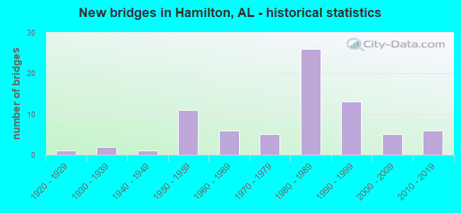
- New bridges - historical statistics
- 11920-1929
- 21930-1939
- 11940-1949
- 111950-1959
- 61960-1969
- 51970-1979
- 261980-1989
- 131990-1999
- 52000-2009
- 62010-2019

- Reconstructed bridges - Historical Statistics
- 31940-1949
- 01950-1959
- 01960-1969
- 11970-1979
- 11980-1989
- 01990-1999
- 02000-2009
- 12010-2019


- Bridge Condition - Deck
- 3.4%Excellent
- 13.8%Very good
- 48.3%Good
- 27.6%Satisfactory
- 6.9%Fair

- Bridge Condition - Superstructure
- 3.4%Excellent
- 17.2%Very good
- 62.1%Good
- 6.9%Satisfactory
- 10.3%Fair

- Bridge Condition - Substructure
- 3.4%Excellent
- 24.1%Very good
- 55.2%Good
- 17.2%Satisfactory

- Bridge Condition - Channel
- 18.0%Very good
- 20.0%Good
- 46.0%Satisfactory
- 16.0%Fair

- Bridge Condition - Culverts
- 3.1%Very good
- 18.8%Good
- 62.5%Satisfactory
- 15.6%Fair
Find on map >> Show street view
Structure Number: 3045, Location: 0.3 MI.W.JCT.AL.219 (Lat: 32.459100, Lng: -87.086983), Route carried "on" structure: State highway 14, Year Built: 1947, Status: Open, Structure Length: 1.40m (4.59ft), Average Daily Traffic: 3,010 (year 2013), Truck Traffic: 9%, Average Future Daily Traffic: 4,054 (year 2033), Design Load: H 15, Features Intersected: STREAM
Minimum Vertical Clearance: 30+ m (98+ ft), Kilometerpoint: 180.005, Lanes on structure: 2, Owner: State Highway Agency, Approaching Roadway Width: 12.8m (42.0ft), Skew: 4 degrees, Material/Design: Concrete continuous, Design/Construction: Culvert, Number Of Spans In Main Unit: 3, Length of Maximum Span: 3.0m (9.8ft)
Condition: Channel: Fair, Culverts: Satisfactory, Operating Rating: 47.8 metric tons, Method Used To Determine Operating Rating: Load Factor (LF), Inventory Rating: 28.7 metric tons, Method Used To Determine Inventory Rating: Load Factor (LF), Structural Evaluation: Equal to present minimum criteria, Waterway Adequacy: Superior to present desirable criteria, Approach Roadway Alignment: Better than present minimum criteria, Length Of Structure Improvement: 2.07m (6.79ft), Designated Inspection Frequency: Every 24 months, Inspection Date: January 2022, Bridge Improvement Cost: $814,000, Roadway Improvement Cost: $81,000, Total Project Cost: $895,000 ( Estimate for 2022)
Find on map >> Show street view
Structure Number: 3948, Location: ONE FOURTH MILE NO OF 278 (Lat: 34.140819, Lng: -87.910133), Route carried "on" structure: County highway 49, Year Built: 1951, Status: Posted for load, Structure Length: 9.54m (31.30ft), Average Daily Traffic: 370 (year 2001), Truck Traffic: 30%, Average Future Daily Traffic: 784 (year 2035), Design Load: H 15, Features Intersected: Buttahatchee River
Minimum Vertical Clearance: 30+ m (98+ ft), Kilometerpoint: 0.010, Lanes on structure: 2, Owner: County Highway Agency, Approaching Roadway Width: 7.3m (24.0ft), Material/Design: Steel continuous, Design/Construction: Stringer/Multi-beam, Number Of Spans In Main Unit: 7, Length of Maximum Span: 24.4m (80.1ft), Curb-To-Curb Width: 6.7m (22.0ft), Out-to-Out Width: 7.3m (24.0ft)
Condition: Deck: Satisfactory, Superstructure: Fair, Substructure: Satisfactory, Channel: Good, Operating Rating: 32.7 metric tons, Method Used To Determine Operating Rating: Load Factor (LF), Inventory Rating: 19.1 metric tons, Method Used To Determine Inventory Rating: Load Factor (LF), Structural Evaluation: Somewhat better than minimum adequacy, Deck Geometry: Meets minimum limits, Waterway Adequacy: Better than present minimum criteria, Approach Roadway Alignment: Better than present minimum criteria, Bridge Posting: Required (Relationship of Operating Rating to Maximum Legal Load: 10.0 - 19.9% below), Length Of Structure Improvement: 10.49m (34.42ft), Designated Inspection Frequency: Every 24 months, Other Special Inspection Frequency: Every 12 months, Inspection Date: March 2021, Other Special Inspection Date: March 2021, Bridge Improvement Cost: $1,726,000, Roadway Improvement Cost: $173,000, Total Project Cost: $1,899,000 ( Estimate for 2022), Deck Structure Type: Concrete Cast-file-Place
Find on map >> Show street view
Structure Number: 4043, Location: 1.4 MI S JCT US 78 (Lat: 34.155722, Lng: -88.057583), Route carried "on" structure: State highway 19, Year Built: 1951, Status: Open, Structure Length: 0.67m (2.20ft), Average Daily Traffic: 220 (year 2017), Truck Traffic: 37%, Average Future Daily Traffic: 302 (year 2033), Design Load: H 15, Features Intersected: Broadtree Creek Branch
Minimum Vertical Clearance: 30+ m (98+ ft), Kilometerpoint: 17.140, Lanes on structure: 2, Owner: State Highway Agency, Approaching Roadway Width: 7.6m (24.9ft), Material/Design: Concrete, Design/Construction: Culvert, Number Of Spans In Main Unit: 2, Length of Maximum Span: 3.0m (9.8ft)
Condition: Channel: Fair, Culverts: Good, Operating Rating: 53.9 metric tons, Method Used To Determine Operating Rating: Load Factor (LF), Inventory Rating: 32.3 metric tons, Method Used To Determine Inventory Rating: Load Factor (LF), Structural Evaluation: Better than present minimum criteria, Waterway Adequacy: Better than present minimum criteria, Approach Roadway Alignment: Better than present minimum criteria, Length Of Structure Improvement: 1.30m (4.27ft), Designated Inspection Frequency: Every 24 months, Inspection Date: December 2020, Bridge Improvement Cost: $218,000, Roadway Improvement Cost: $22,000, Total Project Cost: $240,000 ( Estimate for 2022)
Find on map >> Show street view
Structure Number: 4044, Location: 1.5 MI N JCT US 78 (Lat: 34.195306, Lng: -88.069833), Route carried "on" structure: State highway 19, Year Built: 1951, Status: Open, Structure Length: 1.31m (4.30ft), Average Daily Traffic: 1,310 (year 2017), Truck Traffic: 12%, Average Future Daily Traffic: 1,796 (year 2040), Design Load: H 15, Features Intersected: Broadtree Creek
Minimum Vertical Clearance: 30+ m (98+ ft), Kilometerpoint: 21.665, Lanes on structure: 2, Owner: State Highway Agency, Approaching Roadway Width: 8.8m (28.9ft), Material/Design: Concrete, Design/Construction: Culvert, Number Of Spans In Main Unit: 4, Length of Maximum Span: 3.0m (9.8ft)
Condition: Channel: Satisfactory, Culverts: Good, Operating Rating: 72.5 metric tons, Method Used To Determine Operating Rating: Load Factor (LF), Inventory Rating: 43.5 metric tons, Method Used To Determine Inventory Rating: Load Factor (LF), Structural Evaluation: Better than present minimum criteria, Waterway Adequacy: Better than present minimum criteria, Approach Roadway Alignment: Equal to present desirable criteria, Length Of Structure Improvement: 1.98m (6.50ft), Designated Inspection Frequency: Every 24 months, Inspection Date: December 2020, Bridge Improvement Cost: $413,000, Roadway Improvement Cost: $41,000, Total Project Cost: $454,000 ( Estimate for 2022)
Find on map >> Show street view
Structure Number: 4045, Location: 3.9 MI N JCT US 78 (Lat: 34.228861, Lng: -88.073972), Route carried "on" structure: State highway 19, Year Built: 1951, Status: Open, Structure Length: 1.01m (3.31ft), Average Daily Traffic: 1,310 (year 2017), Truck Traffic: 12%, Average Future Daily Traffic: 1,796 (year 2040), Design Load: H 15, Features Intersected: Glen Creek
Minimum Vertical Clearance: 30+ m (98+ ft), Kilometerpoint: 25.547, Lanes on structure: 2, Owner: State Highway Agency, Approaching Roadway Width: 8.6m (28.2ft), Material/Design: Concrete, Design/Construction: Culvert, Number Of Spans In Main Unit: 3, Length of Maximum Span: 3.0m (9.8ft)
Condition: Channel: Satisfactory, Culverts: Satisfactory, Operating Rating: 57.2 metric tons, Method Used To Determine Operating Rating: Load Factor (LF), Inventory Rating: 34.5 metric tons, Method Used To Determine Inventory Rating: Load Factor (LF), Structural Evaluation: Equal to present minimum criteria, Waterway Adequacy: Equal to present desirable criteria, Approach Roadway Alignment: Better than present minimum criteria, Length Of Structure Improvement: 1.68m (5.51ft), Designated Inspection Frequency: Every 24 months, Inspection Date: December 2020, Bridge Improvement Cost: $311,000, Roadway Improvement Cost: $31,000, Total Project Cost: $342,000 ( Estimate for 2022)
Find on map >> Show street view
Structure Number: 4205, Location: 0.2 MI N JCT US 278 (Lat: 34.145694, Lng: -87.986556), Route carried "on" structure: US 43, Year Built: 1931, Year Reconstructed: 1952, Status: Open, Structure Length: 4.15m (13.62ft), Average Daily Traffic: 8,350 (year 2017), Truck Traffic: 11%, Average Future Daily Traffic: 10,769 (year 2041), Design Load: H 15, Features Intersected: Ragsdale Creek, Facility Carried by Structure: AL-17
Minimum Vertical Clearance: 30+ m (98+ ft), Kilometerpoint: 447.518, Lanes on structure: 4, Base Highway Network: Yes, Owner: State Highway Agency, Approaching Roadway Width: 13.4m (44.0ft), Material/Design: Concrete, Design/Construction: Tee Beam, Number Of Spans In Main Unit: 4, Length of Maximum Span: 10.4m (34.1ft), Curb or Sidewalk Widths: Left: 1.4m (4.6ft), Right: 1.4m (4.6ft), Curb-To-Curb Width: 13.4m (44.0ft), Out-to-Out Width: 16.8m (55.1ft)
Condition: Deck: Fair, Superstructure: Fair, Substructure: Satisfactory, Channel: Satisfactory, Operating Rating: 71.3 metric tons, Method Used To Determine Operating Rating: Load Factor (LF), Inventory Rating: 42.8 metric tons, Method Used To Determine Inventory Rating: Load Factor (LF), Structural Evaluation: Somewhat better than minimum adequacy, Deck Geometry: High priority of replacement, Waterway Adequacy: Better than present minimum criteria, Approach Roadway Alignment: Equal to present desirable criteria, Length Of Structure Improvement: 5.12m (16.80ft), Designated Inspection Frequency: Every 24 months, Inspection Date: January 2021, Bridge Improvement Cost: $1,930,000, Roadway Improvement Cost: $193,000, Total Project Cost: $2,123,000 ( Estimate for 2022), Deck Structure Type: Concrete Cast-file-Place
Find on map >> Show street view
Structure Number: 4206, Location: 1 MI N JCT SR 187 (Lat: 34.207056, Lng: -87.920444), Route carried "on" structure: US 43, Year Built: 1931, Year Reconstructed: 1952, Status: Open, Structure Length: 0.91m (2.99ft), Average Daily Traffic: 3,100 (year 2017), Truck Traffic: 22%, Average Future Daily Traffic: 3,998 (year 2033), Design Load: H 15, Features Intersected: Seven Mile Creek, Facility Carried by Structure: AL-17
Minimum Vertical Clearance: 30+ m (98+ ft), Kilometerpoint: 456.936, Lanes on structure: 2, Base Highway Network: Yes, Owner: State Highway Agency, Approaching Roadway Width: 7.8m (25.6ft), Skew: 9 degrees, Material/Design: Concrete, Design/Construction: Culvert, Number Of Spans In Main Unit: 2, Length of Maximum Span: 3.0m (9.8ft)
Condition: Channel: Satisfactory, Culverts: Fair, Operating Rating: 88.9 metric tons, Method Used To Determine Operating Rating: Load Factor (LF), Inventory Rating: 88.9 metric tons, Method Used To Determine Inventory Rating: Load Factor (LF), Structural Evaluation: Somewhat better than minimum adequacy, Waterway Adequacy: Equal to present desirable criteria, Approach Roadway Alignment: Equal to present desirable criteria, Length Of Structure Improvement: 1.58m (5.18ft), Designated Inspection Frequency: Every 24 months, Inspection Date: January 2021, Bridge Improvement Cost: $1,077,000, Roadway Improvement Cost: $108,000, Total Project Cost: $1,185,000 ( Estimate for 2022)
Find on map >> Show street view
Structure Number: 4254, Location: 10.8 MI. E. HWY. 17 (Lat: 34.042025, Lng: -88.044233), Route carried "on" structure: County highway 35, Year Built: 1952, Status: Open, Structure Length: 0.76m (2.49ft), Average Daily Traffic: 500 (year 2016), Truck Traffic: 4%, Average Future Daily Traffic: 743 (year 2036), Design Load: H 15, Features Intersected: MAYFIELD BRANCH, Facility Carried by Structure: RIVER RD
Minimum Vertical Clearance: 30+ m (98+ ft), Kilometerpoint: 0.010, Lanes on structure: 2, Owner: County Highway Agency, Approaching Roadway Width: 7.9m (25.9ft), Material/Design: Concrete, Design/Construction: Culvert, Number Of Spans In Main Unit: 2, Length of Maximum Span: 3.7m (12.1ft)
Condition: Channel: Satisfactory, Culverts: Satisfactory, Operating Rating: 38.3 metric tons, Method Used To Determine Operating Rating: Load Factor (LF), Inventory Rating: 23.0 metric tons, Method Used To Determine Inventory Rating: Load Factor (LF), Structural Evaluation: Equal to present minimum criteria, Waterway Adequacy: Equal to present minimum criteria, Approach Roadway Alignment: Better than present minimum criteria, Length Of Structure Improvement: 1.41m (4.63ft), Designated Inspection Frequency: Every 24 months, Inspection Date: November 2020, Bridge Improvement Cost: $309,000, Roadway Improvement Cost: $31,000, Total Project Cost: $340,000 ( Estimate for 2022), Wearing Surface/Protective System: Wearing Surface: Bituminous
Find on map >> Show street view
Structure Number: 4709, Location: 2 MILES WEST OF US 78 (Lat: 34.090336, Lng: -88.013258), Route carried "on" structure: County highway 35, Year Built: 1954, Status: Posted for load, Structure Length: 14.20m (46.59ft), Average Daily Traffic: 600 (year 2001), Truck Traffic: 50%, Average Future Daily Traffic: 1,275 (year 2035), Design Load: H 15, Features Intersected: Buttahatchee River
Minimum Vertical Clearance: 30+ m (98+ ft), Kilometerpoint: 0.010, Lanes on structure: 2, Owner: County Highway Agency, Approaching Roadway Width: 7.3m (24.0ft), Material/Design: Steel continuous, Design/Construction: Stringer/Multi-beam, Number Of Spans In Main Unit: 3, Number Of Approach Spans: 6, Length of Maximum Span: 30.5m (100.1ft), Curb-To-Curb Width: 6.7m (22.0ft), Out-to-Out Width: 7.3m (24.0ft)
Condition: Deck: Fair, Superstructure: Fair, Substructure: Good, Channel: Satisfactory, Operating Rating: 35.0 metric tons, Method Used To Determine Operating Rating: Load Factor (LF), Inventory Rating: 21.0 metric tons, Method Used To Determine Inventory Rating: Load Factor (LF), Structural Evaluation: Somewhat better than minimum adequacy, Deck Geometry: Meets minimum limits, Waterway Adequacy: Equal to present minimum criteria, Approach Roadway Alignment: Better than present minimum criteria, Bridge Posting: Required (Relationship of Operating Rating to Maximum Legal Load: 0.1 - 9.9% below), Length Of Structure Improvement: 14.99m (49.18ft), Designated Inspection Frequency: Every 24 months, Other Special Inspection Frequency: Every 12 months, Inspection Date: January 2021, Other Special Inspection Date: January 2022, Bridge Improvement Cost: $2,467,000, Roadway Improvement Cost: $247,000, Total Project Cost: $2,714,000 ( Estimate for 2022), Deck Structure Type: Concrete Cast-file-Place
Find on map >> Show street view
Structure Number: 471, Location: 2 MILES NORTH LAMARCO LIN (Lat: 34.080861, Lng: -88.022056), Route carried "on" structure: County highway 35, Year Built: 1954, Status: Open, Structure Length: 0.67m (2.20ft), Average Daily Traffic: 600 (year 2001), Truck Traffic: 45%, Average Future Daily Traffic: 1,177 (year 2035), Design Load: H 15, Features Intersected: BUTTAHATCHEE RIVER
Minimum Vertical Clearance: 30+ m (98+ ft), Kilometerpoint: 0.010, Lanes on structure: 2, Owner: County Highway Agency, Approaching Roadway Width: 7.3m (24.0ft), Material/Design: Concrete, Design/Construction: Culvert, Number Of Spans In Main Unit: 2, Length of Maximum Span: 3.0m (9.8ft)
Condition: Channel: Satisfactory, Culverts: Satisfactory, Operating Rating: 81.9 metric tons, Method Used To Determine Operating Rating: Load Factor (LF), Inventory Rating: 49.1 metric tons, Method Used To Determine Inventory Rating: Load Factor (LF), Structural Evaluation: Equal to present minimum criteria, Waterway Adequacy: Equal to present minimum criteria, Approach Roadway Alignment: Better than present minimum criteria, Length Of Structure Improvement: 1.30m (4.27ft), Designated Inspection Frequency: Every 24 months, Inspection Date: March 2021, Bridge Improvement Cost: $353,000, Roadway Improvement Cost: $35,000, Total Project Cost: $388,000 ( Estimate for 2022)
Find on map >> Show street view
Structure Number: 4717, Location: 0.3 MI S JCT SR 17 (Lat: 34.129917, Lng: -87.990028), Route carried "on" structure: US 43, Year Built: 1928, Year Reconstructed: 1954, Status: Open, Structure Length: 1.01m (3.31ft), Average Daily Traffic: 13,910 (year 2017), Truck Traffic: 12%, Average Future Daily Traffic: 18,117 (year 2040), Design Load: H 15, Features Intersected: Branch, Facility Carried by Structure: AL-171
Minimum Vertical Clearance: 30+ m (98+ ft), Kilometerpoint: 117.157, Lanes on structure: 5, Base Highway Network: Yes, Owner: State Highway Agency, Approaching Roadway Width: 17.7m (58.1ft), Material/Design: Concrete, Design/Construction: Culvert, Number Of Spans In Main Unit: 3, Length of Maximum Span: 3.0m (9.8ft)
Condition: Channel: Satisfactory, Culverts: Satisfactory, Operating Rating: 76.4 metric tons, Method Used To Determine Operating Rating: Load Factor (LF), Inventory Rating: 45.8 metric tons, Method Used To Determine Inventory Rating: Load Factor (LF), Structural Evaluation: Equal to present minimum criteria, Waterway Adequacy: Equal to present desirable criteria, Approach Roadway Alignment: Equal to present desirable criteria, Length Of Structure Improvement: 1.68m (5.51ft), Designated Inspection Frequency: Every 24 months, Inspection Date: December 2020, Bridge Improvement Cost: $883,000, Roadway Improvement Cost: $88,000, Total Project Cost: $971,000 ( Estimate for 2022)
Find on map >> Show street view
Structure Number: 5352, Location: 2 MI S JCT US 278 (Lat: 34.121056, Lng: -87.835583), Route carried "on" structure: State highway 253, Year Built: 1955, Status: Open, Structure Length: 4.39m (14.40ft), Average Daily Traffic: 120 (year 2019), Truck Traffic: 8%, Average Future Daily Traffic: 167 (year 2041), Design Load: H 15, Features Intersected: Pearce Mill Creek
Minimum Vertical Clearance: 7.56m (24.80ft), Kilometerpoint: 25.439, Lanes on structure: 2, Owner: State Highway Agency, Approaching Roadway Width: 5.2m (17.1ft), Material/Design: Concrete, Design/Construction: Tee Beam, Number Of Spans In Main Unit: 4, Length of Maximum Span: 11.0m (36.1ft), Curb or Sidewalk Widths: Left: 0.2m (0.7ft), Right: 0.2m (0.7ft), Curb-To-Curb Width: 6.7m (22.0ft), Out-to-Out Width: 7.1m (23.3ft)
Condition: Deck: Satisfactory, Superstructure: Good, Substructure: Good, Channel: Satisfactory, Operating Rating: 43.1 metric tons, Method Used To Determine Operating Rating: Load Factor (LF), Inventory Rating: 25.9 metric tons, Method Used To Determine Inventory Rating: Load Factor (LF), Structural Evaluation: Equal to present minimum criteria, Deck Geometry: Meets minimum limits, Waterway Adequacy: Better than present minimum criteria, Approach Roadway Alignment: Equal to present minimum criteria, Length Of Structure Improvement: 5.37m (17.62ft), Designated Inspection Frequency: Every 24 months, Inspection Date: Febuary 2022, Bridge Improvement Cost: $847,000, Roadway Improvement Cost: $85,000, Total Project Cost: $932,000 ( Estimate for 2022), Deck Structure Type: Concrete Cast-file-Place
Find on map >> Show street view
Structure Number: 5376, Location: 3 MILES NO OF HAMILTON (Lat: 34.182056, Lng: -87.984056), Route carried "on" structure: County highway 29, Year Built: 1956, Status: Open, Structure Length: 1.53m (5.02ft), Average Daily Traffic: 160 (year 2001), Truck Traffic: 10%, Average Future Daily Traffic: 206 (year 2036), Design Load: H 15, Features Intersected: WILLIAMS CREEK
Minimum Vertical Clearance: 30+ m (98+ ft), Kilometerpoint: 0.010, Lanes on structure: 2, Owner: County Highway Agency, Approaching Roadway Width: 7.3m (24.0ft), Material/Design: Concrete, Design/Construction: Culvert, Number Of Spans In Main Unit: 4, Length of Maximum Span: 3.7m (12.1ft), Curb-To-Curb Width: 7.7m (25.3ft), Out-to-Out Width: 7.8m (25.6ft)
Condition: Channel: Good, Culverts: Good, Operating Rating: 53.1 metric tons, Method Used To Determine Operating Rating: Load Factor (LF), Inventory Rating: 31.8 metric tons, Method Used To Determine Inventory Rating: Load Factor (LF), Structural Evaluation: Better than present minimum criteria, Deck Geometry: Somewhat better than minimum adequacy, Waterway Adequacy: Better than present minimum criteria, Approach Roadway Alignment: Better than present minimum criteria, Length Of Structure Improvement: 2.21m (7.25ft), Designated Inspection Frequency: Every 24 months, Inspection Date: March 2020, Bridge Improvement Cost: $678,000, Roadway Improvement Cost: $68,000, Total Project Cost: $746,000 ( Estimate for 2022), Deck Structure Type: Concrete Cast-file-Place, Wearing Surface/Protective System: Wearing Surface: Bituminous
Find on map >> Show street view
Structure Number: 5516, Location: 2 MILES NORTH LAMARCO LIN (Lat: 34.085556, Lng: -88.102306), Route carried "on" structure: County highway 22, Year Built: 1956, Status: Open, Structure Length: 1.22m (4.00ft), Average Daily Traffic: 75 (year 2001), Average Future Daily Traffic: 134 (year 2036), Design Load: H 15, Features Intersected: FACTORY CREEK
Minimum Vertical Clearance: 30+ m (98+ ft), Kilometerpoint: 0.010, Lanes on structure: 2, Owner: County Highway Agency, Approaching Roadway Width: 8.5m (27.9ft), Material/Design: Concrete, Design/Construction: Culvert, Number Of Spans In Main Unit: 5, Length of Maximum Span: 3.0m (9.8ft)
Condition: Channel: Fair, Culverts: Satisfactory, Operating Rating: 36.4 metric tons, Method Used To Determine Operating Rating: Load Factor (LF), Inventory Rating: 21.8 metric tons, Method Used To Determine Inventory Rating: Load Factor (LF), Structural Evaluation: Equal to present minimum criteria, Waterway Adequacy: Better than present minimum criteria, Approach Roadway Alignment: Better than present minimum criteria, Length Of Structure Improvement: 1.89m (6.20ft), Designated Inspection Frequency: Every 24 months, Inspection Date: May 2020, Bridge Improvement Cost: $328,000, Roadway Improvement Cost: $33,000, Total Project Cost: $361,000 ( Estimate for 2022)
Find on map >> Show street view
Structure Number: 5748, Location: 4 MI. E. HENSON SPRINGS (Lat: 34.016414, Lng: -87.998744), Route carried "on" structure: County highway 16, Year Built: 1957, Status: Open, Structure Length: 1.01m (3.31ft), Average Daily Traffic: 200 (year 2016), Truck Traffic: 4%, Average Future Daily Traffic: 297 (year 2036), Design Load: H 15, Features Intersected: ESTILL BRANCH, Facility Carried by Structure: HENSON SPRINGS RD
Minimum Vertical Clearance: 30+ m (98+ ft), Kilometerpoint: 0.010, Lanes on structure: 2, Owner: County Highway Agency, Approaching Roadway Width: 8.5m (27.9ft), Skew: 3 degrees, Material/Design: Concrete, Design/Construction: Culvert, Number Of Spans In Main Unit: 3, Length of Maximum Span: 3.0m (9.8ft)
Condition: Channel: Fair, Culverts: Satisfactory, Operating Rating: 35.7 metric tons, Method Used To Determine Operating Rating: Load Factor (LF), Inventory Rating: 21.3 metric tons, Method Used To Determine Inventory Rating: Load Factor (LF), Structural Evaluation: Equal to present minimum criteria, Waterway Adequacy: Equal to present minimum criteria, Approach Roadway Alignment: Equal to present desirable criteria, Length Of Structure Improvement: 1.68m (5.51ft), Designated Inspection Frequency: Every 24 months, Inspection Date: December 2020, Bridge Improvement Cost: $349,000, Roadway Improvement Cost: $35,000, Total Project Cost: $384,000 ( Estimate for 2022), Wearing Surface/Protective System: Wearing Surface: Bituminous
Find on map >> Show street view
Structure Number: 7198, Location: .5 WEST JCT 43 (Lat: 34.170472, Lng: -87.980389), Route carried "on" structure: County highway 1, Year Built: 1961, Status: Open, Structure Length: 2.29m (7.51ft), Average Daily Traffic: 150 (year 2001), Truck Traffic: 10%, Average Future Daily Traffic: 215 (year 2036), Design Load: H 20, Features Intersected: WILLIAMS CREEK, Facility Carried by Structure: PAVED ROAD
Minimum Vertical Clearance: 30+ m (98+ ft), Kilometerpoint: 0.010, Lanes on structure: 2, Owner: County Highway Agency, Approaching Roadway Width: 7.3m (24.0ft), Material/Design: Concrete, Design/Construction: Culvert, Number Of Spans In Main Unit: 5, Length of Maximum Span: 4.3m (14.1ft)
Condition: Channel: Satisfactory, Culverts: Satisfactory, Operating Rating: 47.9 metric tons, Method Used To Determine Operating Rating: Load Factor (LF), Inventory Rating: 28.7 metric tons, Method Used To Determine Inventory Rating: Load Factor (LF), Structural Evaluation: Equal to present minimum criteria, Waterway Adequacy: Better than present minimum criteria, Approach Roadway Alignment: Equal to present minimum criteria, Length Of Structure Improvement: 3.12m (10.24ft), Designated Inspection Frequency: Every 24 months, Inspection Date: March 2020, Bridge Improvement Cost: $540,000, Roadway Improvement Cost: $54,000, Total Project Cost: $594,000 ( Estimate for 2022)
Find on map >> Show street view
Structure Number: 7514, Location: 1 MILE NW OF BARNSVILLE (Lat: 34.147417, Lng: -88.082333), Route carried "on" structure: County highway 11, Year Built: 1962, Status: Open, Structure Length: 1.01m (3.31ft), Average Daily Traffic: 125 (year 2001), Truck Traffic: 10%, Average Future Daily Traffic: 300 (year 2036), Design Load: H 15, Features Intersected: WATTS CREEK
Minimum Vertical Clearance: 30+ m (98+ ft), Kilometerpoint: 0.010, Lanes on structure: 2, Owner: County Highway Agency, Approaching Roadway Width: 7.3m (24.0ft), Material/Design: Concrete, Design/Construction: Culvert, Number Of Spans In Main Unit: 3, Length of Maximum Span: 3.0m (9.8ft)
Condition: Channel: Satisfactory, Culverts: Satisfactory, Operating Rating: 50.0 metric tons, Method Used To Determine Operating Rating: Load Factor (LF), Inventory Rating: 30.0 metric tons, Method Used To Determine Inventory Rating: Load Factor (LF), Structural Evaluation: Equal to present minimum criteria, Waterway Adequacy: Equal to present minimum criteria, Approach Roadway Alignment: Equal to present minimum criteria, Length Of Structure Improvement: 1.68m (5.51ft), Designated Inspection Frequency: Every 24 months, Inspection Date: January 2022, Bridge Improvement Cost: $252,000, Roadway Improvement Cost: $25,000, Total Project Cost: $277,000 ( Estimate for 2022)
Find on map >> Show street view
Structure Number: 7515, Location: 5 MILES SOUTH BARNSVILLE (Lat: 34.135500, Lng: -88.074750), Route carried "on" structure: County highway 131, Year Built: 1962, Status: Open, Structure Length: 0.98m (3.22ft), Average Daily Traffic: 80 (year 2001), Average Future Daily Traffic: 118 (year 2035), Design Load: H 15, Features Intersected: BARNSVILLE CREEK
Minimum Vertical Clearance: 30+ m (98+ ft), Kilometerpoint: 0.010, Lanes on structure: 2, Owner: County Highway Agency, Approaching Roadway Width: 7.3m (24.0ft), Material/Design: Concrete, Design/Construction: Culvert, Number Of Spans In Main Unit: 3, Length of Maximum Span: 3.0m (9.8ft)
Condition: Channel: Good, Culverts: Satisfactory, Operating Rating: 36.7 metric tons, Method Used To Determine Operating Rating: Load Factor (LF), Inventory Rating: 22.0 metric tons, Method Used To Determine Inventory Rating: Load Factor (LF), Structural Evaluation: Equal to present minimum criteria, Waterway Adequacy: Better than present minimum criteria, Approach Roadway Alignment: Better than present minimum criteria, Length Of Structure Improvement: 1.65m (5.41ft), Designated Inspection Frequency: Every 24 months, Inspection Date: December 2020, Bridge Improvement Cost: $248,000, Roadway Improvement Cost: $25,000, Total Project Cost: $273,000 ( Estimate for 2022)
Find on map >> Show street view
Structure Number: 878, Location: 0.2 MI E 2ND ST NW (Lat: 34.148333, Lng: -87.988333), Route carried "on" structure: City street , Year Built: 1965, Status: Open, Structure Length: 0.91m (2.99ft), Average Daily Traffic: 125 (year 2016), Truck Traffic: 2%, Average Future Daily Traffic: 200 (year 2036), Features Intersected: RAGSDALE CREEK, Facility Carried by Structure: ACADEMY DR
Minimum Vertical Clearance: 30+ m (98+ ft), Kilometerpoint: 0.000, Lanes on structure: 2, Owner: City or Municipal Highway Agency, Approaching Roadway Width: 7.3m (24.0ft), Material/Design: Concrete, Design/Construction: Culvert, Number Of Spans In Main Unit: 3, Length of Maximum Span: 3.0m (9.8ft), Curb-To-Curb Width: 7.2m (23.6ft), Out-to-Out Width: 7.7m (25.3ft)
Condition: Channel: Satisfactory, Culverts: Fair, Operating Rating: 66.0 metric tons, Method Used To Determine Operating Rating: Load Factor (LF), Inventory Rating: 39.6 metric tons, Method Used To Determine Inventory Rating: Load Factor (LF), Structural Evaluation: Somewhat better than minimum adequacy, Deck Geometry: Meets minimum limits, Waterway Adequacy: Equal to present minimum criteria, Approach Roadway Alignment: Better than present minimum criteria, Length Of Structure Improvement: 1.59m (5.22ft), Designated Inspection Frequency: Every 24 months, Inspection Date: January 2022, Bridge Improvement Cost: $229,000, Roadway Improvement Cost: $23,000, Total Project Cost: $252,000 ( Estimate for 2022)
Find on map >> Show street view
Structure Number: 894, Location: 1 MILE SOUTH OF ST RD 278 (Lat: 34.121389, Lng: -87.926528), Route carried "on" structure: County highway 51, Year Built: 1966, Status: Open, Structure Length: 1.38m (4.53ft), Average Daily Traffic: 125 (year 2001), Truck Traffic: 15%, Average Future Daily Traffic: 246 (year 2035), Design Load: H 20, Features Intersected: Woods Creek
Minimum Vertical Clearance: 30+ m (98+ ft), Kilometerpoint: 0.010, Lanes on structure: 2, Owner: County Highway Agency, Approaching Roadway Width: 7.3m (24.0ft), Skew: 3 degrees, Material/Design: Concrete, Design/Construction: Culvert, Number Of Spans In Main Unit: 3, Length of Maximum Span: 3.7m (12.1ft)
Condition: Channel: Satisfactory, Culverts: Satisfactory, Operating Rating: 49.9 metric tons, Method Used To Determine Operating Rating: Load Factor (LF), Inventory Rating: 29.9 metric tons, Method Used To Determine Inventory Rating: Load Factor (LF), Structural Evaluation: Equal to present minimum criteria, Waterway Adequacy: Better than present minimum criteria, Approach Roadway Alignment: Equal to present minimum criteria, Length Of Structure Improvement: 2.05m (6.73ft), Designated Inspection Frequency: Every 24 months, Inspection Date: March 2021, Bridge Improvement Cost: $367,000, Roadway Improvement Cost: $37,000, Total Project Cost: $404,000 ( Estimate for 2022)
Find on map >> Show street view
Structure Number: 9477, Location: 5 MILES SE HAMILTON (Lat: 34.125667, Lng: -87.904583), Route carried "on" structure: County highway 91, Year Built: 1968, Status: Open, Structure Length: 0.94m (3.08ft), Average Daily Traffic: 80 (year 2001), Average Future Daily Traffic: 157 (year 2035), Design Load: H 15, Features Intersected: Woods Creek
Minimum Vertical Clearance: 30+ m (98+ ft), Kilometerpoint: 0.010, Lanes on structure: 2, Owner: County Highway Agency, Approaching Roadway Width: 7.3m (24.0ft), Material/Design: Concrete, Design/Construction: Culvert, Number Of Spans In Main Unit: 3, Length of Maximum Span: 3.0m (9.8ft)
Condition: Channel: Satisfactory, Culverts: Satisfactory, Operating Rating: 33.1 metric tons, Method Used To Determine Operating Rating: Load Factor (LF), Inventory Rating: 19.9 metric tons, Method Used To Determine Inventory Rating: Load Factor (LF), Structural Evaluation: Somewhat better than minimum adequacy, Waterway Adequacy: Better than present minimum criteria, Approach Roadway Alignment: Better than present minimum criteria, Length Of Structure Improvement: 1.61m (5.28ft), Designated Inspection Frequency: Every 24 months, Inspection Date: March 2021, Bridge Improvement Cost: $260,000, Roadway Improvement Cost: $26,000, Total Project Cost: $286,000 ( Estimate for 2022)
Find on map >> Show street view
Structure Number: 11022, Location: 0.3 MILE OF CO. 42 (Lat: 34.105906, Lng: -87.965003), Route carried "on" structure: County highway 98, Year Built: 1974, Status: Open, Structure Length: 1.95m (6.40ft), Average Daily Traffic: 35 (year 2001), Average Future Daily Traffic: 98 (year 2035), Design Load: H 15, Features Intersected: Woods Creek
Minimum Vertical Clearance: 30+ m (98+ ft), Kilometerpoint: 0.010, Lanes on structure: 2, Owner: County Highway Agency, Approaching Roadway Width: 4.9m (16.1ft), Material/Design: Concrete, Design/Construction: Channel Beam, Number Of Spans In Main Unit: 2, Length of Maximum Span: 10.4m (34.1ft), Curb-To-Curb Width: 6.8m (22.3ft), Out-to-Out Width: 7.7m (25.3ft)
Condition: Deck: Satisfactory, Superstructure: Satisfactory, Substructure: Satisfactory, Channel: Satisfactory, Operating Rating: 44.1 metric tons, Method Used To Determine Operating Rating: Load Factor (LF), Inventory Rating: 26.5 metric tons, Method Used To Determine Inventory Rating: Load Factor (LF), Structural Evaluation: Equal to present minimum criteria, Deck Geometry: Somewhat better than minimum adequacy, Waterway Adequacy: Equal to present minimum criteria, Approach Roadway Alignment: High priority of corrective action, Length Of Structure Improvement: 2.69m (8.83ft), Designated Inspection Frequency: Every 24 months, Inspection Date: March 2021, Bridge Improvement Cost: $461,000, Roadway Improvement Cost: $46,000, Total Project Cost: $507,000 ( Estimate for 2022), Deck Structure Type: Concrete Precast Panels
Find on map >> Show street view
Structure Number: 11992, Location: 1 MI N JCT US-278 (Lat: 34.155556, Lng: -87.978111), Route carried "on" structure: US 43, Year Built: 1973, Status: Open, Structure Length: 12.37m (40.58ft), Average Daily Traffic: 4,800 (year 2019), Truck Traffic: 16%, Average Future Daily Traffic: 6,190 (year 2041), Design Load: HS 20, Features Intersected: Williams Creek, Facility Carried by Structure: AL-17
Minimum Vertical Clearance: 30+ m (98+ ft), Kilometerpoint: 448.843, Lanes on structure: 2, Base Highway Network: Yes, Owner: State Highway Agency, Approaching Roadway Width: 12.9m (42.3ft), Skew: 4 degrees, Material/Design: Steel continuous, Design/Construction: Stringer/Multi-beam, Number Of Spans In Main Unit: 3, Number Of Approach Spans: 6, Length of Maximum Span: 24.4m (80.1ft), Curb or Sidewalk Widths: Left: 0.2m (0.7ft), Right: 0.2m (0.7ft), Curb-To-Curb Width: 13.4m (44.0ft), Out-to-Out Width: 14.5m (47.6ft)
Condition: Deck: Satisfactory, Superstructure: Good, Substructure: Good, Channel: Good, Operating Rating: 44.2 metric tons, Method Used To Determine Operating Rating: Load Factor (LF), Inventory Rating: 26.6 metric tons, Method Used To Determine Inventory Rating: Load Factor (LF), Structural Evaluation: Equal to present minimum criteria, Deck Geometry: Better than present minimum criteria, Waterway Adequacy: Equal to present minimum criteria, Approach Roadway Alignment: Equal to present minimum criteria, Length Of Structure Improvement: 13.21m (43.34ft), Designated Inspection Frequency: Every 24 months, Inspection Date: January 2021, Bridge Improvement Cost: $4,257,000, Roadway Improvement Cost: $426,000, Total Project Cost: $4,683,000 ( Estimate for 2022), Deck Structure Type: Concrete Cast-file-Place
Find on map >> Show street view
Structure Number: 12165, Location: 8 MI N JCT AL-17 (Lat: 34.141278, Lng: -88.084972), Route carried "on" structure: State highway 19, Year Built: 1979, Status: Open, Structure Length: 7.25m (23.79ft), Average Daily Traffic: 480 (year 2013), Truck Traffic: 19%, Average Future Daily Traffic: 658 (year 2040), Design Load: HS 20, Features Intersected: Barnsville Creek
Minimum Vertical Clearance: 30+ m (98+ ft), Kilometerpoint: 13.100, Lanes on structure: 2, Owner: State Highway Agency, Approaching Roadway Width: 7.4m (24.3ft), Skew: 3 degrees, Material/Design: Prestressed concrete continuous, Design/Construction: Stringer/Multi-beam, Number Of Spans In Main Unit: 7, Length of Maximum Span: 10.4m (34.1ft), Curb or Sidewalk Widths: Left: 0.2m (0.7ft), Right: 0.2m (0.7ft), Curb-To-Curb Width: 10.4m (34.1ft), Out-to-Out Width: 11.3m (37.1ft)
Condition: Deck: Satisfactory, Superstructure: Good, Substructure: Good, Channel: Satisfactory, Operating Rating: 63.1 metric tons, Method Used To Determine Operating Rating: Allowable Stress (AS), Inventory Rating: 45.7 metric tons, Method Used To Determine Inventory Rating: Allowable Stress (AS), Structural Evaluation: Better than present minimum criteria, Deck Geometry: Equal to present minimum criteria, Waterway Adequacy: Equal to present minimum criteria, Approach Roadway Alignment: Better than present minimum criteria, Length Of Structure Improvement: 8.28m (27.17ft), Designated Inspection Frequency: Every 24 months, Inspection Date: December 2020, Bridge Improvement Cost: $2,100,000, Roadway Improvement Cost: $210,000, Total Project Cost: $2,310,000 ( Estimate for 2022), Deck Structure Type: Concrete Cast-file-Place
Find on map >> Show street view
Structure Number: 12448, Location: .2 MILE SOUTH JCT CO 29 (Lat: 34.179972, Lng: -87.972750), Route carried "on" structure: County highway , Year Built: 1981, Status: Open, Structure Length: 1.28m (4.20ft), Average Daily Traffic: 55 (year 2001), Average Future Daily Traffic: 80 (year 2036), Design Load: H 20, Features Intersected: STEVENS CREEK, Facility Carried by Structure: LOVEJOY ROAD
Minimum Vertical Clearance: 30+ m (98+ ft), Kilometerpoint: 0.010, Lanes on structure: 2, Owner: County Highway Agency, Approaching Roadway Width: 8.5m (27.9ft), Material/Design: Concrete, Design/Construction: Culvert, Number Of Spans In Main Unit: 4, Length of Maximum Span: 3.0m (9.8ft)
Condition: Channel: Good, Culverts: Fair, Operating Rating: 69.1 metric tons, Method Used To Determine Operating Rating: Load Factor (LF), Inventory Rating: 41.5 metric tons, Method Used To Determine Inventory Rating: Load Factor (LF), Structural Evaluation: Somewhat better than minimum adequacy, Waterway Adequacy: Superior to present desirable criteria, Approach Roadway Alignment: Better than present minimum criteria, Length Of Structure Improvement: 1.95m (6.40ft), Designated Inspection Frequency: Every 24 months, Inspection Date: March 2020, Bridge Improvement Cost: $361,000, Roadway Improvement Cost: $36,000, Total Project Cost: $397,000 ( Estimate for 2022)
Find on map >> Show street view
Structure Number: 13152, Location: 1 MILE WEST OF CO RD 25 (Lat: 34.197992, Lng: -88.055147), Route carried "on" structure: County highway , Year Built: 1970, Year Reconstructed: 1984, Status: Open, Structure Length: 0.67m (2.20ft), Average Daily Traffic: 50 (year 2001), Average Future Daily Traffic: 98 (year 2035), Design Load: H 20, Features Intersected: Boardtree Creek, Facility Carried by Structure: County Road 122
Minimum Vertical Clearance: 30+ m (98+ ft), Kilometerpoint: 0.010, Lanes on structure: 2, Owner: County Highway Agency, Approaching Roadway Width: 8.5m (27.9ft), Material/Design: Concrete, Design/Construction: Culvert, Number Of Spans In Main Unit: 2, Length of Maximum Span: 3.0m (9.8ft)
Condition: Channel: Good, Culverts: Satisfactory, Operating Rating: 42.2 metric tons, Method Used To Determine Operating Rating: Load Factor (LF), Inventory Rating: 25.3 metric tons, Method Used To Determine Inventory Rating: Load Factor (LF), Structural Evaluation: Equal to present minimum criteria, Waterway Adequacy: Better than present minimum criteria, Approach Roadway Alignment: Better than present minimum criteria, Length Of Structure Improvement: 1.30m (4.27ft), Designated Inspection Frequency: Every 24 months, Inspection Date: March 2021, Bridge Improvement Cost: $165,000, Roadway Improvement Cost: $17,000, Total Project Cost: $182,000 ( Estimate for 2022)
Find on map >> Show street view
Structure Number: 13683, Location: 3.01 MI W AL-74 (Lat: 34.189889, Lng: -88.108556), Route carried "on" structure: County highway 4, Year Built: 1986, Status: Open, Structure Length: 8.90m (29.20ft), Average Daily Traffic: 300 (year 2018), Truck Traffic: 3%, Average Future Daily Traffic: 1,000 (year 2040), Design Load: HS 20, Features Intersected: I-22, Facility Carried by Structure: CR-11
Minimum Vertical Clearance: 30+ m (98+ ft), Kilometerpoint: 4.699, Lanes on structure: 2, Lanes under structure: 4, Owner: State Highway Agency, Approaching Roadway Width: 6.2m (20.3ft), Skew: 2 degrees, Material/Design: Steel, Design/Construction: Stringer/Multi-beam, Number Of Spans In Main Unit: 2, Number Of Approach Spans: 2, Length of Maximum Span: 30.2m (99.1ft), Curb-To-Curb Width: 8.5m (27.9ft), Out-to-Out Width: 9.4m (30.8ft)
Condition: Deck: Good, Superstructure: Good, Substructure: Good, Operating Rating: 53.2 metric tons, Method Used To Determine Operating Rating: Load Factor (LF), Inventory Rating: 31.8 metric tons, Method Used To Determine Inventory Rating: Load Factor (LF), Structural Evaluation: Better than present minimum criteria, Deck Geometry: Equal to present minimum criteria, Underclear: Better than present minimum criteria, Approach Roadway Alignment: Better than present minimum criteria, Length Of Structure Improvement: 9.87m (32.38ft), Designated Inspection Frequency: Every 24 months, Inspection Date: May 2020, Bridge Improvement Cost: $2,031,000, Roadway Improvement Cost: $203,000, Total Project Cost: $2,234,000 ( Estimate for 2022), Deck Structure Type: Concrete Cast-file-Place
Find on map >> Show street view
Structure Number: 1369, Location: 2.2 MI S JCT SR 17 (Lat: 34.102706, Lng: -87.988992), Route carried "on" structure: US 43, Year Built: 1985, Year Reconstructed: 2017, Status: Open, Structure Length: 6.22m (20.41ft), Average Daily Traffic: 6,360 (year 2017), Truck Traffic: 14%, Average Future Daily Traffic: 8,284 (year 2041), Design Load: HS 20, Features Intersected: Buttahatchee Rvr Relief, Facility Carried by Structure: AL-171
Minimum Vertical Clearance: 30+ m (98+ ft), Kilometerpoint: 114.177, Lanes on structure: 4, Base Highway Network: Yes, Owner: State Highway Agency, Approaching Roadway Width: 25.0m (82.0ft), Material/Design: Steel, Design/Construction: Stringer/Multi-beam, Number Of Spans In Main Unit: 6, Length of Maximum Span: 10.4m (34.1ft), Curb or Sidewalk Widths: Left: 0.2m (0.7ft), Right: 0.2m (0.7ft), Curb-To-Curb Width: 25.0m (82.0ft), Out-to-Out Width: 25.8m (84.6ft)
Condition: Deck: Good, Superstructure: Good, Substructure: Good, Channel: Very good, Operating Rating: 88.9 metric tons, Method Used To Determine Operating Rating: Load Factor (LF), Inventory Rating: 54.4 metric tons, Method Used To Determine Inventory Rating: Load Factor (LF), Structural Evaluation: Better than present minimum criteria, Deck Geometry: Superior to present desirable criteria, Waterway Adequacy: Equal to present desirable criteria, Approach Roadway Alignment: Equal to present desirable criteria, Length Of Structure Improvement: 7.26m (23.82ft), Designated Inspection Frequency: Every 24 months, Inspection Date: September 2021, Bridge Improvement Cost: $4,182,000, Roadway Improvement Cost: $418,000, Total Project Cost: $4,600,000 ( Estimate for 2022), Deck Structure Type: Concrete Cast-file-Place
Find on map >> Show street view
Structure Number: 1407, Location: 2 MILES NORTH US 78 (Lat: 34.200389, Lng: -88.043639), Route carried "on" structure: County highway 25, Year Built: 1987, Status: Open, Structure Length: 0.85m (2.79ft), Average Daily Traffic: 210 (year 2001), Truck Traffic: 20%, Average Future Daily Traffic: 412 (year 2035), Design Load: HS 20, Features Intersected: Boardtree Creek
Minimum Vertical Clearance: 30+ m (98+ ft), Kilometerpoint: 0.010, Lanes on structure: 2, Owner: County Highway Agency, Approaching Roadway Width: 13.4m (44.0ft), Material/Design: Steel, Design/Construction: Culvert, Number Of Spans In Main Unit: 3, Length of Maximum Span: 2.1m (6.9ft)
Condition: Channel: Satisfactory, Culverts: Satisfactory, Operating Rating: 39.4 metric tons, Method Used To Determine Operating Rating: Load Factor (LF), Inventory Rating: 36.0 metric tons, Method Used To Determine Inventory Rating: Load Factor (LF), Structural Evaluation: Equal to present minimum criteria, Waterway Adequacy: Equal to present minimum criteria, Approach Roadway Alignment: Better than present minimum criteria, Length Of Structure Improvement: 1.51m (4.95ft), Designated Inspection Frequency: Every 24 months, Inspection Date: March 2021, Bridge Improvement Cost: $454,000, Roadway Improvement Cost: $45,000, Total Project Cost: $499,000 ( Estimate for 2022)
Find on map >> Show street view
Structure Number: 14429, Location: 0.3MILE NORTH OF JCT 78 (Lat: 34.182111, Lng: -88.079417), Route carried "on" structure: County highway , Year Built: 1973, Year Reconstructed: 1988, Status: Open, Structure Length: 1.58m (5.18ft), Average Daily Traffic: 45 (year 2001), Average Future Daily Traffic: 65 (year 2035), Design Load: HS 20, Features Intersected: Boardtree Creek, Facility Carried by Structure: Boardtree Road
Minimum Vertical Clearance: 30+ m (98+ ft), Kilometerpoint: 0.010, Lanes on structure: 2, Owner: County Highway Agency, Approaching Roadway Width: 7.3m (24.0ft), Material/Design: Concrete, Design/Construction: Culvert, Number Of Spans In Main Unit: 4, Length of Maximum Span: 3.7m (12.1ft), Curb-To-Curb Width: 8.5m (27.9ft), Out-to-Out Width: 9.1m (29.9ft)
Condition: Channel: Satisfactory, Culverts: Good, Operating Rating: 67.6 metric tons, Method Used To Determine Operating Rating: Load Factor (LF), Inventory Rating: 40.6 metric tons, Method Used To Determine Inventory Rating: Load Factor (LF), Structural Evaluation: Better than present minimum criteria, Deck Geometry: Better than present minimum criteria, Waterway Adequacy: Better than present minimum criteria, Approach Roadway Alignment: Better than present minimum criteria, Length Of Structure Improvement: 2.26m (7.41ft), Designated Inspection Frequency: Every 24 months, Inspection Date: December 2020, Bridge Improvement Cost: $392,000, Roadway Improvement Cost: $39,000, Total Project Cost: $431,000 ( Estimate for 2022), Deck Structure Type: Concrete Cast-file-Place, Wearing Surface/Protective System: Wearing Surface: Bituminous
Find on map >> Show street view
Structure Number: 14503, Location: JCT AL-74 AND AL-4 (Lat: 34.167222, Lng: -88.065167), Route carried "on" structure: US 74, Year Built: 1988, Status: Open, Structure Length: 9.27m (30.41ft), Average Daily Traffic: 2,140 (year 2018), Truck Traffic: 12%, Average Future Daily Traffic: 2,722 (year 2033), Design Load: HS 20, Features Intersected: I-22
Minimum Vertical Clearance: 30+ m (98+ ft), Kilometerpoint: 0.161, Lanes on structure: 3, Lanes under structure: 4, Base Highway Network: Yes, Owner: State Highway Agency, Approaching Roadway Width: 14.9m (48.9ft), Skew: 1 degrees, Material/Design: Prestressed concrete, Design/Construction: Stringer/Multi-beam, Number Of Spans In Main Unit: 4, Length of Maximum Span: 28.0m (91.9ft), Curb-To-Curb Width: 15.8m (51.8ft), Out-to-Out Width: 16.7m (54.8ft)
Condition: Deck: Good, Superstructure: Good, Substructure: Good, Operating Rating: 63.0 metric tons, Method Used To Determine Operating Rating: Load Factor (LF), Inventory Rating: 37.7 metric tons, Method Used To Determine Inventory Rating: Load Factor (LF), Structural Evaluation: Better than present minimum criteria, Deck Geometry: Better than present minimum criteria, Underclear: Better than present minimum criteria, Approach Roadway Alignment: Equal to present desirable criteria, Length Of Structure Improvement: 10.23m (33.56ft), Designated Inspection Frequency: Every 24 months, Inspection Date: January 2022, Bridge Improvement Cost: $3,786,000, Roadway Improvement Cost: $379,000, Total Project Cost: $4,165,000 ( Estimate for 2022), Deck Structure Type: Concrete Cast-file-Place
Find on map >> Show street view
Structure Number: 14541, Location: JCT AL-17 AND AL-4 (Lat: 34.120014, Lng: -88.045828), Route carried "on" structure: State highway 17, Year Built: 1988, Status: Open, Structure Length: 10.27m (33.69ft), Average Daily Traffic: 1,990 (year 2019), Truck Traffic: 16%, Average Future Daily Traffic: 2,566 (year 2041), Design Load: HS 20, Features Intersected: I-22
Minimum Vertical Clearance: 30+ m (98+ ft), Kilometerpoint: 440.992, Lanes on structure: 2, Lanes under structure: 4, Owner: State Highway Agency, Approaching Roadway Width: 15.2m (49.9ft), Skew: 3 degrees, Material/Design: Steel continuous, Design/Construction: Stringer/Multi-beam, Number Of Spans In Main Unit: 2, Number Of Approach Spans: 2, Length of Maximum Span: 48.8m (160.1ft), Curb-To-Curb Width: 15.8m (51.8ft), Out-to-Out Width: 16.7m (54.8ft)
Condition: Deck: Satisfactory, Superstructure: Good, Substructure: Good, Operating Rating: 66.4 metric tons, Method Used To Determine Operating Rating: Load Factor (LF), Inventory Rating: 41.2 metric tons, Method Used To Determine Inventory Rating: Load Factor (LF), Structural Evaluation: Better than present minimum criteria, Deck Geometry: Superior to present desirable criteria, Underclear: Equal to present desirable criteria, Approach Roadway Alignment: Equal to present desirable criteria, Length Of Structure Improvement: 11.19m (36.71ft), Designated Inspection Frequency: Every 24 months, Inspection Date: January 2021, Bridge Improvement Cost: $4,142,000, Roadway Improvement Cost: $414,000, Total Project Cost: $4,556,000 ( Estimate for 2022), Deck Structure Type: Concrete Cast-file-Place
Find on map >> Show street view
Structure Number: 14544, Location: JCT AL-19 AND AL-4 (Lat: 34.147333, Lng: -88.059583), Route carried "on" structure: State highway 19, Year Built: 1988, Status: Open, Structure Length: 8.99m (29.49ft), Average Daily Traffic: 470 (year 2019), Truck Traffic: 19%, Average Future Daily Traffic: 644 (year 2041), Design Load: HS 20, Features Intersected: I-22
Minimum Vertical Clearance: 30+ m (98+ ft), Kilometerpoint: 15.183, Lanes on structure: 2, Lanes under structure: 4, Owner: State Highway Agency, Approaching Roadway Width: 7.4m (24.3ft), Material/Design: Prestressed concrete, Design/Construction: Stringer/Multi-beam, Number Of Spans In Main Unit: 4, Length of Maximum Span: 27.1m (88.9ft), Curb-To-Curb Width: 10.4m (34.1ft), Out-to-Out Width: 11.2m (36.7ft)
Condition: Deck: Good, Superstructure: Good, Substructure: Good, Operating Rating: 67.1 metric tons, Method Used To Determine Operating Rating: Load Factor (LF), Inventory Rating: 40.2 metric tons, Method Used To Determine Inventory Rating: Load Factor (LF), Structural Evaluation: Better than present minimum criteria, Deck Geometry: Equal to present minimum criteria, Underclear: Equal to present desirable criteria, Approach Roadway Alignment: Better than present minimum criteria, Length Of Structure Improvement: 9.96m (32.68ft), Designated Inspection Frequency: Every 24 months, Inspection Date: January 2021, Bridge Improvement Cost: $2,458,000, Roadway Improvement Cost: $246,000, Total Project Cost: $2,704,000 ( Estimate for 2022), Deck Structure Type: Concrete Cast-file-Place
Find on map >> Show street view
Structure Number: 14639, Location: 0.2 MI S AL 74 (Lat: 34.164056, Lng: -88.062944), Route carried "on" structure: Interstate 22, Year Built: 1988, Status: Open, Structure Length: 1.04m (3.41ft), Average Daily Traffic: 11,490 (year 2013), Truck Traffic: 38%, Average Future Daily Traffic: 15,567 (year 2040), Design Load: HS 20, Features Intersected: Creek
Minimum Vertical Clearance: 30+ m (98+ ft), Kilometerpoint: 12.905, Lanes on structure: 4, Base Highway Network: Yes, Owner: State Highway Agency, Approaching Roadway Width: 24.0m (78.7ft), Skew: 11 degrees, Material/Design: Concrete, Design/Construction: Culvert, Number Of Spans In Main Unit: 3, Length of Maximum Span: 3.0m (9.8ft)
Condition: Channel: Fair, Culverts: Satisfactory, Operating Rating: 88.9 metric tons, Method Used To Determine Operating Rating: Load Factor (LF), Inventory Rating: 88.9 metric tons, Method Used To Determine Inventory Rating: Load Factor (LF), Structural Evaluation: Equal to present minimum criteria, Waterway Adequacy: Equal to present minimum criteria, Approach Roadway Alignment: Equal to present desirable criteria, Length Of Structure Improvement: 1.71m (5.61ft), Designated Inspection Frequency: Every 24 months, Inspection Date: Febuary 2022, Bridge Improvement Cost: $3,333,000, Roadway Improvement Cost: $333,000, Total Project Cost: $3,666,000 ( Estimate for 2022)
Find on map >> Show street view
Structure Number: 14641, Location: 0.5 MI S AL-19 (Lat: 34.140528, Lng: -88.058694), Route carried "on" structure: Interstate 22, Year Built: 1988, Status: Open, Structure Length: 13.41m (44.00ft), Average Daily Traffic: 11,490 (year 2013), Truck Traffic: 38%, Average Future Daily Traffic: 15,567 (year 2038), Design Load: HS 20, Features Intersected: Branch
Minimum Vertical Clearance: 30+ m (98+ ft), Kilometerpoint: 15.545, Lanes on structure: 4, Base Highway Network: Yes, Owner: State Highway Agency, Approaching Roadway Width: 24.0m (78.7ft), Skew: 13 degrees, Material/Design: Concrete, Design/Construction: Culvert, Number Of Spans In Main Unit: 2, Length of Maximum Span: 2.4m (7.9ft)
Condition: Channel: Satisfactory, Culverts: Satisfactory, Operating Rating: 88.9 metric tons, Method Used To Determine Operating Rating: Load Factor (LF), Inventory Rating: 88.9 metric tons, Method Used To Determine Inventory Rating: Load Factor (LF), Structural Evaluation: Equal to present minimum criteria, Waterway Adequacy: Better than present minimum criteria, Approach Roadway Alignment: Equal to present desirable criteria, Length Of Structure Improvement: 14.22m (46.65ft), Designated Inspection Frequency: Every 24 months, Inspection Date: May 2020, Bridge Improvement Cost: $34,412,000, Roadway Improvement Cost: $3,441,000, Total Project Cost: $37,853,000 ( Estimate for 2022)
Find on map >> Show street view
Structure Number: 14643, Location: 0.9 MI S AL-17 (Lat: 34.113778, Lng: -88.030972), Route carried "on" structure: County highway 4, Year Built: 1988, Status: Open, Structure Length: 11.67m (38.29ft), Average Daily Traffic: 275 (year 2018), Truck Traffic: 2%, Average Future Daily Traffic: 1,025 (year 2040), Design Load: HS 20, Features Intersected: I-22, Facility Carried by Structure: CR-11
Minimum Vertical Clearance: 30+ m (98+ ft), Kilometerpoint: 20.020, Lanes on structure: 2, Lanes under structure: 4, Owner: State Highway Agency, Approaching Roadway Width: 7.2m (23.6ft), Skew: 4 degrees, Material/Design: Steel continuous, Design/Construction: Stringer/Multi-beam, Number Of Spans In Main Unit: 2, Number Of Approach Spans: 2, Length of Maximum Span: 37.2m (122.0ft), Curb-To-Curb Width: 8.5m (27.9ft), Out-to-Out Width: 9.4m (30.8ft)
Condition: Deck: Good, Superstructure: Good, Substructure: Good, Operating Rating: 71.5 metric tons, Method Used To Determine Operating Rating: Load Factor (LF), Inventory Rating: 42.8 metric tons, Method Used To Determine Inventory Rating: Load Factor (LF), Structural Evaluation: Better than present minimum criteria, Deck Geometry: Equal to present minimum criteria, Underclear: Better than present minimum criteria, Approach Roadway Alignment: Better than present minimum criteria, Length Of Structure Improvement: 12.54m (41.14ft), Designated Inspection Frequency: Every 24 months, Inspection Date: June 2020, Bridge Improvement Cost: $2,579,000, Roadway Improvement Cost: $258,000, Total Project Cost: $2,837,000 ( Estimate for 2022), Deck Structure Type: Concrete Cast-file-Place
Find on map >> Show street view
Structure Number: 14646, Location: 2.4 MI W AL-171 (Lat: 34.090778, Lng: -88.008361), Route carried "on" structure: County highway 4, Year Built: 1988, Status: Open, Structure Length: 9.27m (30.41ft), Average Daily Traffic: 525 (year 2018), Truck Traffic: 2%, Average Future Daily Traffic: 2,000 (year 2040), Design Load: HS 20, Features Intersected: I-22, Facility Carried by Structure: CR-35
Minimum Vertical Clearance: 30+ m (98+ ft), Kilometerpoint: 14.389, Lanes on structure: 2, Lanes under structure: 4, Owner: State Highway Agency, Approaching Roadway Width: 14.5m (47.6ft), Skew: 2 degrees, Material/Design: Steel continuous, Design/Construction: Stringer/Multi-beam, Number Of Spans In Main Unit: 2, Number Of Approach Spans: 2, Length of Maximum Span: 30.5m (100.1ft), Curb-To-Curb Width: 13.4m (44.0ft), Out-to-Out Width: 14.3m (46.9ft)
Condition: Deck: Good, Superstructure: Good, Substructure: Good, Operating Rating: 59.3 metric tons, Method Used To Determine Operating Rating: Load Factor (LF), Inventory Rating: 35.6 metric tons, Method Used To Determine Inventory Rating: Load Factor (LF), Structural Evaluation: Better than present minimum criteria, Deck Geometry: Superior to present desirable criteria, Underclear: Better than present minimum criteria, Approach Roadway Alignment: Equal to present desirable criteria, Length Of Structure Improvement: 10.23m (33.56ft), Designated Inspection Frequency: Every 24 months, Inspection Date: June 2020, Bridge Improvement Cost: $3,226,000, Roadway Improvement Cost: $323,000, Total Project Cost: $3,549,000 ( Estimate for 2022), Deck Structure Type: Concrete Cast-file-Place
Find on map >> Show street view
Structure Number: 14647, Location: 1.4 MI W AL-171 (Lat: 34.079250, Lng: -87.996639), Route carried "on" structure: County highway 4, Year Built: 1988, Status: Open, Structure Length: 12.50m (41.01ft), Average Daily Traffic: 450 (year 2020), Truck Traffic: 2%, Average Future Daily Traffic: 1,025 (year 2040), Design Load: HS 20, Features Intersected: I-22, Facility Carried by Structure: CR-55
Minimum Vertical Clearance: 30+ m (98+ ft), Kilometerpoint: 15.400, Lanes on structure: 2, Lanes under structure: 4, Owner: State Highway Agency, Approaching Roadway Width: 6.3m (20.7ft), Skew: 4 degrees, Material/Design: Steel continuous, Design/Construction: Stringer/Multi-beam, Number Of Spans In Main Unit: 2, Number Of Approach Spans: 2, Length of Maximum Span: 39.9m (130.9ft), Curb-To-Curb Width: 8.5m (27.9ft), Out-to-Out Width: 9.5m (31.2ft)
Condition: Deck: Good, Superstructure: Good, Substructure: Good, Operating Rating: 64.3 metric tons, Method Used To Determine Operating Rating: Load Factor (LF), Inventory Rating: 38.5 metric tons, Method Used To Determine Inventory Rating: Load Factor (LF), Structural Evaluation: Better than present minimum criteria, Deck Geometry: Somewhat better than minimum adequacy, Underclear: Somewhat better than minimum adequacy, Approach Roadway Alignment: Better than present minimum criteria, Length Of Structure Improvement: 13.34m (43.77ft), Designated Inspection Frequency: Every 24 months, Inspection Date: June 2020, Bridge Improvement Cost: $2,835,000, Roadway Improvement Cost: $284,000, Total Project Cost: $3,119,000 ( Estimate for 2022), Deck Structure Type: Concrete Cast-file-Place
Find on map >> Show street view
Structure Number: 14648, Location: 0.3 MI N AL-171 (Lat: 34.072250, Lng: -87.981389), Route carried "on" structure: County highway 4, Year Built: 1988, Status: Open, Structure Length: 9.91m (32.51ft), Average Daily Traffic: 55 (year 2020), Truck Traffic: 1%, Average Future Daily Traffic: 195 (year 2040), Design Load: HS 20, Features Intersected: I-22, Facility Carried by Structure: Berryhill Road
Minimum Vertical Clearance: 30+ m (98+ ft), Kilometerpoint: 16.468, Lanes on structure: 2, Lanes under structure: 4, Owner: State Highway Agency, Approaching Roadway Width: 7.3m (24.0ft), Skew: 2 degrees, Material/Design: Prestressed concrete, Design/Construction: Stringer/Multi-beam, Number Of Spans In Main Unit: 4, Length of Maximum Span: 29.9m (98.1ft), Curb-To-Curb Width: 8.5m (27.9ft), Out-to-Out Width: 9.6m (31.5ft)
Condition: Deck: Good, Superstructure: Good, Substructure: Good, Operating Rating: 51.4 metric tons, Method Used To Determine Operating Rating: Load Factor (LF), Inventory Rating: 32.7 metric tons, Method Used To Determine Inventory Rating: Load Factor (LF), Structural Evaluation: Better than present minimum criteria, Deck Geometry: Better than present minimum criteria, Underclear: Better than present minimum criteria, Approach Roadway Alignment: Better than present minimum criteria, Length Of Structure Improvement: 10.84m (35.56ft), Designated Inspection Frequency: Every 24 months, Inspection Date: June 2020, Bridge Improvement Cost: $2,305,000, Roadway Improvement Cost: $231,000, Total Project Cost: $2,536,000 ( Estimate for 2022), Deck Structure Type: Concrete Cast-file-Place
Find on map >> Show street view
Structure Number: 14899, Location: 4 MILES SE OF HAMILTON (Lat: 34.112861, Lng: -87.940806), Route carried "on" structure: County highway 42, Year Built: 1989, Status: Open, Structure Length: 2.38m (7.81ft), Average Daily Traffic: 240 (year 2001), Truck Traffic: 35%, Average Future Daily Traffic: 471 (year 2035), Design Load: HS 20, Features Intersected: Woods Creek
Minimum Vertical Clearance: 30+ m (98+ ft), Kilometerpoint: 0.010, Lanes on structure: 2, Owner: County Highway Agency, Approaching Roadway Width: 7.9m (25.9ft), Skew: 3 degrees, Material/Design: Concrete, Design/Construction: Culvert, Number Of Spans In Main Unit: 4, Length of Maximum Span: 4.9m (16.1ft)
Condition: Channel: Satisfactory, Culverts: Satisfactory, Operating Rating: 88.9 metric tons, Method Used To Determine Operating Rating: Load Factor (LF), Inventory Rating: 87.7 metric tons, Method Used To Determine Inventory Rating: Load Factor (LF), Structural Evaluation: Equal to present minimum criteria, Waterway Adequacy: Equal to present minimum criteria, Approach Roadway Alignment: Better than present minimum criteria, Length Of Structure Improvement: 3.23m (10.60ft), Designated Inspection Frequency: Every 24 months, Inspection Date: March 2021, Bridge Improvement Cost: $1,194,000, Roadway Improvement Cost: $119,000, Total Project Cost: $1,313,000 ( Estimate for 2022)
Find on map >> Show street view
Structure Number: 15518, Location: ONE HALF MILE NO OFOLD 78 (Lat: 34.167722, Lng: -88.007889), Route carried "on" structure: County highway , Year Built: 1992, Status: Open, Structure Length: 0.67m (2.20ft), Average Daily Traffic: 20 (year 2001), Average Future Daily Traffic: 39 (year 2035), Design Load: HS 20, Features Intersected: Ragsdale Creek, Facility Carried by Structure: County Road 329
Minimum Vertical Clearance: 30+ m (98+ ft), Kilometerpoint: 0.010, Lanes on structure: 2, Owner: County Highway Agency, Approaching Roadway Width: 7.3m (24.0ft), Skew: 3 degrees, Material/Design: Concrete, Design/Construction: Culvert, Number Of Spans In Main Unit: 2, Length of Maximum Span: 3.0m (9.8ft)
Condition: Channel: Good, Culverts: Good, Operating Rating: 88.9 metric tons, Method Used To Determine Operating Rating: Load Factor (LF), Inventory Rating: 68.6 metric tons, Method Used To Determine Inventory Rating: Load Factor (LF), Structural Evaluation: Better than present minimum criteria, Waterway Adequacy: Better than present minimum criteria, Approach Roadway Alignment: Equal to present minimum criteria, Length Of Structure Improvement: 1.30m (4.27ft), Designated Inspection Frequency: Every 24 months, Inspection Date: March 2021, Bridge Improvement Cost: $443,000, Roadway Improvement Cost: $44,000, Total Project Cost: $487,000 ( Estimate for 2022)
Find on map >> Show street view
Structure Number: 15527, Location: 4 MI W JCT AL-253 (Lat: 34.133139, Lng: -87.870000), Route carried "on" structure: US 278, Year Built: 1992, Status: Open, Structure Length: 13.96m (45.80ft), Average Daily Traffic: 1,850 (year 2020), Truck Traffic: 14%, Average Future Daily Traffic: 2,150 (year 2040), Design Load: HS 20, Features Intersected: Buttahatchee River, Facility Carried by Structure: AL-74
Minimum Vertical Clearance: 30+ m (98+ ft), Kilometerpoint: 19.264, Lanes on structure: 2, Base Highway Network: Yes, Owner: State Highway Agency, Approaching Roadway Width: 12.3m (40.4ft), Skew: 2 degrees, Material/Design: Prestressed concrete continuous, Design/Construction: Stringer/Multi-beam, Number Of Spans In Main Unit: 8, Length of Maximum Span: 23.8m (78.1ft), Curb-To-Curb Width: 13.4m (44.0ft), Out-to-Out Width: 14.2m (46.6ft)
Condition: Deck: Good, Superstructure: Good, Substructure: Very good, Channel: Very good, Operating Rating: 65.2 metric tons, Method Used To Determine Operating Rating: Load Factor (LF), Inventory Rating: 45.9 metric tons, Method Used To Determine Inventory Rating: Load Factor (LF), Structural Evaluation: Better than present minimum criteria, Deck Geometry: Equal to present desirable criteria, Waterway Adequacy: Superior to present desirable criteria, Approach Roadway Alignment: Equal to present desirable criteria, Length Of Structure Improvement: 14.76m (48.43ft), Designated Inspection Frequency: Every 24 months, Inspection Date: January 2022, Bridge Improvement Cost: $4,655,000, Roadway Improvement Cost: $466,000, Total Project Cost: $5,121,000 ( Estimate for 2022), Deck Structure Type: Concrete Cast-file-Place