Bridge Statistics for Gulfport, Mississippi (MS)
Condition, Traffic, Stress, Structural Evaluation, Project Costs
- National Bridge Inventory (NBI) Statistics
- 89Number of bridges
- 2,723ft / 830mTotal length
- $3,703,153,000Total costs
- 1,408,406Total average daily traffic
- 160,055Total average daily truck traffic
- National Bridge Inventory (NBI) Registered Bridges for Gulfport
- No street view available for this location
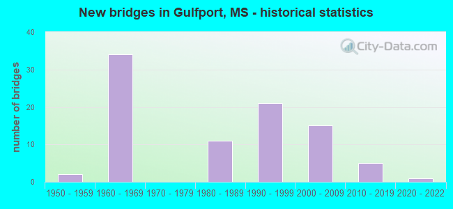
- New bridges - historical statistics
- 21950-1959
- 341960-1969
- 111980-1989
- 211990-1999
- 152000-2009
- 52010-2019
- 12020-2022

- Reconstructed bridges - Historical Statistics
- 11980-1989
- 01990-1999
- 162000-2009


- Bridge Condition - Deck
- 5.6%Very good
- 63.9%Good
- 23.6%Satisfactory
- 5.6%Fair
- 1.4%Poor

- Bridge Condition - Superstructure
- 30.6%Very good
- 48.6%Good
- 13.9%Satisfactory
- 5.6%Fair
- 1.4%Poor

- Bridge Condition - Substructure
- 38.9%Very good
- 36.1%Good
- 13.9%Satisfactory
- 9.7%Fair
- 1.4%Poor

- Bridge Condition - Channel
- 9.2%Excellent
- 18.5%Very good
- 38.5%Good
- 21.5%Satisfactory
- 10.8%Fair
- 1.5%Poor

- Bridge Condition - Culverts
- 60.0%Very good
- 20.0%Good
- 20.0%Fair
Find on map >> Show street view
Structure Number: 1100010023, Location: MISS/LA STATE LINE (Lat: 30.301553, Lng: -89.649531), Route carried "on" structure: Interstate 10, Year Built: 1966, Status: Open, Structure Length: 152.03m (498.79ft), Average Daily Traffic: 46,000 (year 2020), Truck Traffic: 24%, Average Future Daily Traffic: 63,000 (year 2040), Design Load: HS 20+Mod, Features Intersected: EAST PEARL RIVER
Minimum Vertical Clearance: 30+ m (98+ ft), Kilometerpoint: 0.000, Lanes on structure: 4, Base Highway Network: Yes (Inventory Route: 1, Subroute: 1), Owner: State Highway Agency, Approaching Roadway Width: 24.4m (80.1ft), Navigation Control: Yes ( Vertical Clearance: 22.0m (72.2ft), Horizontal Clearance: 35.0m (114.8ft)), Material/Design: Steel, Design/Construction: Girder and Floorbeam System, Number Of Spans In Main Unit: 1, Number Of Approach Spans: 74, Length of Maximum Span: 50.3m (165.0ft), Curb-To-Curb Width: 17.7m (58.1ft), Out-to-Out Width: 20.1m (65.9ft)
Condition: Deck: Good, Superstructure: Satisfactory, Substructure: Satisfactory, Channel: Good, Operating Rating: 72.7 metric tons, Method Used To Determine Operating Rating: Load Factor (LF), Inventory Rating: 35.1 metric tons, Method Used To Determine Inventory Rating: Load Factor (LF), Structural Evaluation: Equal to present minimum criteria, Deck Geometry: Meets minimum limits, Waterway Adequacy: Equal to present desirable criteria, Approach Roadway Alignment: Equal to present desirable criteria, Length Of Structure Improvement: 152.03m (498.79ft), Designated Inspection Frequency: Every 24 months, Critical Feature Inspection Frequency: Every 12 months, Underwater Inspection Frequency: Every 60 months, Inspection Date: September 2021, Critical Feature Inspection Date: September 2021, Underwater Inspection Date: July 2019, Bridge Improvement Cost: $999,999,000, Roadway Improvement Cost: $130,000,000, Total Project Cost: $999,999,000, Deck Structure Type: Concrete Cast-file-Place
Find on map >> Show street view
Structure Number: 11000100240309, Location: 4.4 MI W US 49 (Lat: 30.417936, Lng: -89.169028), Route carried "on" structure: Interstate 10, Year Built: 1969, Status: Open, Structure Length: 0.67m (2.20ft), Average Daily Traffic: 61,000 (year 2020), Truck Traffic: 15%, Average Future Daily Traffic: 65,000 (year 2040), Design Load: HS 20+Mod, Features Intersected: FLAT BRANCH
Minimum Vertical Clearance: 30+ m (98+ ft), Kilometerpoint: 17.308, Lanes on structure: 6, Base Highway Network: Yes (Inventory Route: 1, Subroute: 1), Owner: State Highway Agency, Approaching Roadway Width: 52.4m (171.9ft), Material/Design: Concrete, Design/Construction: Culvert, Number Of Spans In Main Unit: 2, Length of Maximum Span: 3.0m (9.8ft)
Condition: Channel: Good, Culverts: Good, Structural Evaluation: Better than present minimum criteria, Waterway Adequacy: Equal to present desirable criteria, Approach Roadway Alignment: Equal to present desirable criteria, Length Of Structure Improvement: 0.67m (2.20ft), Designated Inspection Frequency: Every 24 months, Inspection Date: November 2021, Bridge Improvement Cost: $86,000,000, Roadway Improvement Cost: $200,000,000, Total Project Cost: $286,000,000
Find on map >> Show street view
Structure Number: 11000100240321A, Location: 3.4 MI W US 49 (Lat: 30.422528, Lng: -89.149544), Route carried "on" structure: Interstate 10, Year Built: 1969, Year Reconstructed: 2000, Status: Open, Structure Length: 6.10m (20.01ft), Average Daily Traffic: 30,500 (year 2020), Truck Traffic: 15%, Average Future Daily Traffic: 32,500 (year 2040), Design Load: HS 20+Mod, Features Intersected: TURKEY CREEK
Minimum Vertical Clearance: 30+ m (98+ ft), Kilometerpoint: 26.726, Lanes on structure: 3, Base Highway Network: Yes (Inventory Route: 1, Subroute: 1), Owner: State Highway Agency, Approaching Roadway Width: 18.3m (60.0ft), Material/Design: Prestressed concrete, Design/Construction: Stringer/Multi-beam, Number Of Spans In Main Unit: 5, Length of Maximum Span: 12.2m (40.0ft), Curb-To-Curb Width: 17.5m (57.4ft), Out-to-Out Width: 18.3m (60.0ft)
Condition: Deck: Good, Superstructure: Good, Substructure: Good, Channel: Good, Operating Rating: 57.9 metric tons, Method Used To Determine Operating Rating: Load Factor (LF), Inventory Rating: 32.6 metric tons, Method Used To Determine Inventory Rating: Load Factor (LF), Structural Evaluation: Better than present minimum criteria, Deck Geometry: Better than present minimum criteria, Waterway Adequacy: Equal to present desirable criteria, Approach Roadway Alignment: Equal to present desirable criteria, Designated Inspection Frequency: Every 24 months, Inspection Date: November 2021, Deck Structure Type: Concrete Cast-file-Place
Find on map >> Show street view
Structure Number: 11000100240321B, Location: 3.4 MI W US 49 (Lat: 30.422094, Lng: -89.150061), Route carried "on" structure: Interstate 10, Year Built: 1969, Year Reconstructed: 2000, Status: Open, Structure Length: 6.10m (20.01ft), Average Daily Traffic: 30,500 (year 2020), Truck Traffic: 15%, Average Future Daily Traffic: 32,500 (year 2040), Design Load: HS 20+Mod, Features Intersected: TURKEY CREEK
Minimum Vertical Clearance: 30+ m (98+ ft), Kilometerpoint: 19.188, Lanes on structure: 3, Base Highway Network: Yes (Inventory Route: 1, Subroute: 1), Owner: State Highway Agency, Approaching Roadway Width: 18.3m (60.0ft), Material/Design: Prestressed concrete, Design/Construction: Stringer/Multi-beam, Number Of Spans In Main Unit: 5, Length of Maximum Span: 12.2m (40.0ft), Curb-To-Curb Width: 17.5m (57.4ft), Out-to-Out Width: 18.3m (60.0ft)
Condition: Deck: Good, Superstructure: Very good, Substructure: Very good, Channel: Good, Operating Rating: 57.9 metric tons, Method Used To Determine Operating Rating: Load Factor (LF), Inventory Rating: 32.6 metric tons, Method Used To Determine Inventory Rating: Load Factor (LF), Structural Evaluation: Equal to present desirable criteria, Deck Geometry: Better than present minimum criteria, Waterway Adequacy: Equal to present desirable criteria, Approach Roadway Alignment: Equal to present desirable criteria, Designated Inspection Frequency: Every 24 months, Inspection Date: November 2021, Deck Structure Type: Concrete Cast-file-Place
Find on map >> Show street view
Structure Number: 11000100240329A, Location: 2.6 MI W US 49 (Lat: 30.424392, Lng: -89.136247), Route carried "on" structure: Interstate 10, Year Built: 1969, Year Reconstructed: 2000, Status: Open, Structure Length: 7.32m (24.02ft), Average Daily Traffic: 30,500 (year 2020), Truck Traffic: 15%, Average Future Daily Traffic: 32,500 (year 2040), Design Load: HS 20+Mod, Features Intersected: CANAL ROAD
Minimum Vertical Clearance: 30+ m (98+ ft), Kilometerpoint: 25.426, Lanes on structure: 3, Lanes under structure: 2, Base Highway Network: Yes (Inventory Route: 1, Subroute: 1), Owner: State Highway Agency, Approaching Roadway Width: 18.3m (60.0ft), Material/Design: Prestressed concrete, Design/Construction: Stringer/Multi-beam, Number Of Spans In Main Unit: 2, Number Of Approach Spans: 2, Length of Maximum Span: 24.4m (80.1ft), Curb-To-Curb Width: 17.5m (57.4ft), Out-to-Out Width: 18.3m (60.0ft)
Condition: Deck: Good, Superstructure: Good, Substructure: Very good, Operating Rating: 57.9 metric tons, Method Used To Determine Operating Rating: Load Factor (LF), Inventory Rating: 32.6 metric tons, Method Used To Determine Inventory Rating: Load Factor (LF), Structural Evaluation: Better than present minimum criteria, Deck Geometry: Better than present minimum criteria, Underclear: Better than present minimum criteria, Approach Roadway Alignment: Equal to present desirable criteria, Designated Inspection Frequency: Every 24 months, Inspection Date: November 2021, Deck Structure Type: Concrete Cast-file-Place
Find on map >> Show street view
Structure Number: 11000100240329B, Location: 2.6 MI W US 49 (Lat: 30.424086, Lng: -89.137000), Route carried "on" structure: Interstate 10, Year Built: 1969, Year Reconstructed: 2000, Status: Open, Structure Length: 7.32m (24.02ft), Average Daily Traffic: 30,500 (year 2020), Truck Traffic: 15%, Average Future Daily Traffic: 32,500 (year 2040), Design Load: HS 20+Mod, Features Intersected: CANAL ROAD
Minimum Vertical Clearance: 30+ m (98+ ft), Kilometerpoint: 20.468, Lanes on structure: 3, Lanes under structure: 2, Base Highway Network: Yes (Inventory Route: 1, Subroute: 1), Owner: State Highway Agency, Approaching Roadway Width: 18.3m (60.0ft), Material/Design: Prestressed concrete, Design/Construction: Stringer/Multi-beam, Number Of Spans In Main Unit: 2, Number Of Approach Spans: 2, Length of Maximum Span: 24.4m (80.1ft), Curb-To-Curb Width: 17.5m (57.4ft), Out-to-Out Width: 18.3m (60.0ft)
Condition: Deck: Good, Superstructure: Good, Substructure: Very good, Operating Rating: 57.9 metric tons, Method Used To Determine Operating Rating: Load Factor (LF), Inventory Rating: 32.6 metric tons, Method Used To Determine Inventory Rating: Load Factor (LF), Structural Evaluation: Better than present minimum criteria, Deck Geometry: Better than present minimum criteria, Underclear: Better than present minimum criteria, Approach Roadway Alignment: Equal to present desirable criteria, Designated Inspection Frequency: Every 24 months, Inspection Date: November 2021, Deck Structure Type: Concrete Cast-file-Place
Find on map >> Show street view
Structure Number: 11000100240355B, Location: 0.1 MI W US 49 (Lat: 30.432197, Lng: -89.096047), Route carried "on" structure: Interstate 10, Year Built: 1969, Year Reconstructed: 2000, Status: Open, Structure Length: 4.63m (15.19ft), Average Daily Traffic: 31,500 (year 2020), Truck Traffic: 16%, Average Future Daily Traffic: 33,500 (year 2040), Design Load: HS 20+Mod, Features Intersected: KCS RR
Minimum Vertical Clearance: 30+ m (98+ ft), Kilometerpoint: 21.445, Lanes on structure: 3, Base Highway Network: Yes (Inventory Route: 1, Subroute: 1), Owner: State Highway Agency, Approaching Roadway Width: 18.9m (62.0ft), Material/Design: Prestressed concrete, Design/Construction: Stringer/Multi-beam, Number Of Spans In Main Unit: 3, Length of Maximum Span: 15.2m (49.9ft), Curb-To-Curb Width: 18.0m (59.1ft), Out-to-Out Width: 18.9m (62.0ft)
Condition: Deck: Good, Superstructure: Good, Substructure: Good, Operating Rating: 65.0 metric tons, Method Used To Determine Operating Rating: Load Factor (LF), Inventory Rating: 36.5 metric tons, Method Used To Determine Inventory Rating: Load Factor (LF), Structural Evaluation: Better than present minimum criteria, Deck Geometry: Better than present minimum criteria, Underclear: Equal to present minimum criteria, Approach Roadway Alignment: Equal to present desirable criteria, Designated Inspection Frequency: Every 24 months, Inspection Date: November 2021, Deck Structure Type: Concrete Cast-file-Place
Find on map >> Show street view
Structure Number: 11000100240355C, Location: 0.1 MI W US 49 (Lat: 30.431864, Lng: -89.096483), Route carried "on" structure: Interstate 10, Year Built: 1969, Year Reconstructed: 2000, Status: Open, Structure Length: 4.63m (15.19ft), Average Daily Traffic: 31,500 (year 2020), Truck Traffic: 16%, Average Future Daily Traffic: 33,500 (year 2040), Design Load: HS 20+Mod, Features Intersected: KCS RR
Minimum Vertical Clearance: 30+ m (98+ ft), Kilometerpoint: 24.478, Lanes on structure: 3, Base Highway Network: Yes (Inventory Route: 1, Subroute: 1), Owner: State Highway Agency, Approaching Roadway Width: 18.9m (62.0ft), Material/Design: Prestressed concrete, Design/Construction: Stringer/Multi-beam, Number Of Spans In Main Unit: 3, Length of Maximum Span: 15.2m (49.9ft), Curb-To-Curb Width: 18.0m (59.1ft), Out-to-Out Width: 18.9m (62.0ft)
Condition: Deck: Good, Superstructure: Very good, Substructure: Very good, Operating Rating: 65.3 metric tons, Method Used To Determine Operating Rating: Load Factor (LF), Inventory Rating: 36.5 metric tons, Method Used To Determine Inventory Rating: Load Factor (LF), Structural Evaluation: Equal to present desirable criteria, Deck Geometry: Better than present minimum criteria, Underclear: Equal to present minimum criteria, Approach Roadway Alignment: Equal to present desirable criteria, Designated Inspection Frequency: Every 24 months, Inspection Date: November 2021, Deck Structure Type: Concrete Cast-file-Place
Find on map >> Show street view
Structure Number: 11000100240357A, Location: I 10 OVER US 49 (Lat: 30.432908, Lng: -89.093381), Route carried "on" structure: Interstate 10, Year Built: 1969, Year Reconstructed: 2000, Status: Open, Structure Length: 8.26m (27.10ft), Average Daily Traffic: 31,500 (year 2020), Truck Traffic: 16%, Average Future Daily Traffic: 33,500 (year 2040), Design Load: HS 20+Mod, Features Intersected: US 49
Minimum Vertical Clearance: 30+ m (98+ ft), Kilometerpoint: 21.177, Lanes on structure: 4, Lanes under structure: 8, Base Highway Network: Yes (Inventory Route: 1, Subroute: 1), Owner: State Highway Agency, Approaching Roadway Width: 21.9m (71.9ft), Material/Design: Prestressed concrete, Design/Construction: Stringer/Multi-beam, Number Of Spans In Main Unit: 2, Number Of Approach Spans: 2, Length of Maximum Span: 25.0m (82.0ft), Curb-To-Curb Width: 21.7m (71.2ft), Out-to-Out Width: 22.6m (74.1ft)
Condition: Deck: Good, Superstructure: Good, Substructure: Very good, Operating Rating: 51.3 metric tons, Method Used To Determine Operating Rating: Load Factor (LF), Inventory Rating: 30.7 metric tons, Method Used To Determine Inventory Rating: Load Factor (LF), Structural Evaluation: Better than present minimum criteria, Deck Geometry: Better than present minimum criteria, Underclear: Better than present minimum criteria, Approach Roadway Alignment: Equal to present desirable criteria, Designated Inspection Frequency: Every 24 months, Inspection Date: November 2021, Deck Structure Type: Concrete Cast-file-Place
Find on map >> Show street view
Structure Number: 11000100240357B, Location: I 10 OVER US 49 (Lat: 30.432506, Lng: -89.094072), Route carried "on" structure: Interstate 10, Year Built: 1969, Year Reconstructed: 2000, Status: Open, Structure Length: 8.26m (27.10ft), Average Daily Traffic: 31,500 (year 2020), Truck Traffic: 16%, Average Future Daily Traffic: 33,500 (year 2040), Design Load: HS 20+Mod, Features Intersected: US 49
Minimum Vertical Clearance: 30+ m (98+ ft), Kilometerpoint: 24.720, Lanes on structure: 4, Lanes under structure: 8, Base Highway Network: Yes (Inventory Route: 1, Subroute: 1), Owner: State Highway Agency, Approaching Roadway Width: 21.9m (71.9ft), Material/Design: Prestressed concrete, Design/Construction: Stringer/Multi-beam, Number Of Spans In Main Unit: 2, Number Of Approach Spans: 2, Length of Maximum Span: 25.0m (82.0ft), Curb-To-Curb Width: 21.7m (71.2ft), Out-to-Out Width: 22.6m (74.1ft)
Condition: Deck: Good, Superstructure: Satisfactory, Substructure: Very good, Operating Rating: 51.5 metric tons, Method Used To Determine Operating Rating: Load Factor (LF), Inventory Rating: 30.8 metric tons, Method Used To Determine Inventory Rating: Load Factor (LF), Structural Evaluation: Equal to present minimum criteria, Deck Geometry: Better than present minimum criteria, Underclear: Better than present minimum criteria, Approach Roadway Alignment: Equal to present desirable criteria, Designated Inspection Frequency: Every 24 months, Inspection Date: November 2021, Deck Structure Type: Concrete Cast-file-Place
Find on map >> Show street view
Structure Number: 11000100240359B, Location: 0.2 MI E US 49 (Lat: 30.433772, Lng: -89.090153), Route carried "on" structure: Interstate 10, Year Built: 1969, Year Reconstructed: 2000, Status: Open, Structure Length: 9.75m (31.99ft), Average Daily Traffic: 31,500 (year 2020), Truck Traffic: 16%, Average Future Daily Traffic: 33,500 (year 2040), Design Load: HS 20+Mod, Features Intersected: BERNARD BAYOU
Minimum Vertical Clearance: 30+ m (98+ ft), Kilometerpoint: 20.852, Lanes on structure: 3, Base Highway Network: Yes (Inventory Route: 1, Subroute: 1), Owner: State Highway Agency, Approaching Roadway Width: 18.3m (60.0ft), Skew: 2 degrees, Material/Design: Prestressed concrete, Design/Construction: Stringer/Multi-beam, Number Of Spans In Main Unit: 1, Number Of Approach Spans: 6, Length of Maximum Span: 21.3m (69.9ft), Curb-To-Curb Width: 18.0m (59.1ft), Out-to-Out Width: 18.9m (62.0ft)
Condition: Deck: Good, Superstructure: Very good, Substructure: Very good, Channel: Very good, Operating Rating: 56.6 metric tons, Method Used To Determine Operating Rating: Load Factor (LF), Inventory Rating: 33.9 metric tons, Method Used To Determine Inventory Rating: Load Factor (LF), Structural Evaluation: Equal to present desirable criteria, Deck Geometry: Better than present minimum criteria, Waterway Adequacy: Equal to present desirable criteria, Approach Roadway Alignment: Equal to present desirable criteria, Designated Inspection Frequency: Every 24 months, Inspection Date: November 2021, Deck Structure Type: Concrete Cast-file-Place
Find on map >> Show street view
Structure Number: 11000100240359C, Location: 0.2 MI E US 49 (Lat: 30.433358, Lng: -89.090919), Route carried "on" structure: Interstate 10, Year Built: 1969, Year Reconstructed: 2000, Status: Open, Structure Length: 9.75m (31.99ft), Average Daily Traffic: 31,500 (year 2020), Truck Traffic: 16%, Average Future Daily Traffic: 33,500 (year 2040), Design Load: HS 20+Mod, Features Intersected: BERNARD BAYOU
Minimum Vertical Clearance: 30+ m (98+ ft), Kilometerpoint: 25.037, Lanes on structure: 3, Base Highway Network: Yes (Inventory Route: 1, Subroute: 1), Owner: State Highway Agency, Approaching Roadway Width: 18.3m (60.0ft), Skew: 2 degrees, Material/Design: Prestressed concrete, Design/Construction: Stringer/Multi-beam, Number Of Spans In Main Unit: 1, Number Of Approach Spans: 6, Length of Maximum Span: 21.3m (69.9ft), Curb-To-Curb Width: 18.0m (59.1ft), Out-to-Out Width: 18.9m (62.0ft)
Condition: Deck: Good, Superstructure: Very good, Substructure: Very good, Channel: Good, Operating Rating: 56.6 metric tons, Method Used To Determine Operating Rating: Load Factor (LF), Inventory Rating: 33.9 metric tons, Method Used To Determine Inventory Rating: Load Factor (LF), Structural Evaluation: Equal to present desirable criteria, Deck Geometry: Better than present minimum criteria, Waterway Adequacy: Equal to present desirable criteria, Approach Roadway Alignment: Equal to present desirable criteria, Designated Inspection Frequency: Every 24 months, Inspection Date: November 2021, Deck Structure Type: Concrete Cast-file-Place
Find on map >> Show street view
Structure Number: 11000100240362A, Location: 0.5 MI E US 49 (Lat: 30.435000, Lng: -89.085533), Route carried "on" structure: Interstate 10, Year Built: 1969, Year Reconstructed: 2000, Status: Open, Structure Length: 9.45m (31.00ft), Average Daily Traffic: 29,000 (year 2020), Truck Traffic: 17%, Average Future Daily Traffic: 30,500 (year 2040), Design Load: HS 20+Mod, Features Intersected: THREE RIVERS ROAD
Minimum Vertical Clearance: 30+ m (98+ ft), Kilometerpoint: 20.387, Lanes on structure: 3, Lanes under structure: 2, Base Highway Network: Yes (Inventory Route: 1, Subroute: 1), Owner: State Highway Agency, Approaching Roadway Width: 18.3m (60.0ft), Skew: 4 degrees, Material/Design: Concrete continuous, Design/Construction: Box Beam or Girders - Single/Spread, Number Of Spans In Main Unit: 3, Length of Maximum Span: 42.7m (140.1ft), Curb-To-Curb Width: 18.0m (59.1ft), Out-to-Out Width: 18.9m (62.0ft)
Condition: Deck: Good, Superstructure: Good, Substructure: Very good, Operating Rating: 58.7 metric tons, Method Used To Determine Operating Rating: Load Factor (LF), Inventory Rating: 31.7 metric tons, Method Used To Determine Inventory Rating: Load Factor (LF), Structural Evaluation: Better than present minimum criteria, Deck Geometry: Better than present minimum criteria, Underclear: Meets minimum limits, Approach Roadway Alignment: Equal to present desirable criteria, Designated Inspection Frequency: Every 24 months, Inspection Date: November 2021, Deck Structure Type: Concrete Cast-file-Place
Find on map >> Show street view
Structure Number: 11000100240362B, Location: 0.5 MI E US 49 (Lat: 30.434483, Lng: -89.086656), Route carried "on" structure: Interstate 10, Year Built: 1969, Year Reconstructed: 2000, Status: Open, Structure Length: 11.09m (36.38ft), Average Daily Traffic: 29,000 (year 2020), Truck Traffic: 17%, Average Future Daily Traffic: 30,500 (year 2040), Design Load: HS 20+Mod, Features Intersected: THREE RIVERS ROAD
Minimum Vertical Clearance: 30+ m (98+ ft), Kilometerpoint: 25.466, Lanes on structure: 4, Lanes under structure: 2, Base Highway Network: Yes (Inventory Route: 1, Subroute: 1), Owner: State Highway Agency, Approaching Roadway Width: 21.9m (71.9ft), Skew: 4 degrees, Material/Design: Concrete continuous, Design/Construction: Box Beam or Girders - Single/Spread, Number Of Spans In Main Unit: 4, Length of Maximum Span: 42.7m (140.1ft), Curb-To-Curb Width: 21.7m (71.2ft), Out-to-Out Width: 22.6m (74.1ft)
Condition: Deck: Good, Superstructure: Good, Substructure: Very good, Operating Rating: 64.5 metric tons, Method Used To Determine Operating Rating: Load Factor (LF), Inventory Rating: 38.9 metric tons, Method Used To Determine Inventory Rating: Load Factor (LF), Structural Evaluation: Better than present minimum criteria, Deck Geometry: Better than present minimum criteria, Underclear: Somewhat better than minimum adequacy, Approach Roadway Alignment: Equal to present desirable criteria, Designated Inspection Frequency: Every 24 months, Inspection Date: November 2021, Deck Structure Type: Concrete Cast-file-Place
Find on map >> Show street view
Structure Number: 11000100240368, Location: 1.1 MI E US 49 (Lat: 30.436917, Lng: -89.077475), Route carried "on" structure: Interstate 10, Year Built: 1969, Status: Open, Structure Length: 0.73m (2.40ft), Average Daily Traffic: 58,000 (year 2020), Truck Traffic: 17%, Average Future Daily Traffic: 61,000 (year 2040), Design Load: HS 20+Mod, Features Intersected: STREAM
Minimum Vertical Clearance: 30+ m (98+ ft), Kilometerpoint: 26.388, Lanes on structure: 6, Base Highway Network: Yes (Inventory Route: 1, Subroute: 1), Owner: State Highway Agency, Approaching Roadway Width: 48.8m (160.1ft), Material/Design: Concrete, Design/Construction: Culvert, Number Of Spans In Main Unit: 2, Length of Maximum Span: 3.0m (9.8ft)
Condition: Channel: Poor, Culverts: Fair, Inventory Rating: 77.4 metric tons, Method Used To Determine Inventory Rating: Load Factor (LF), Structural Evaluation: Somewhat better than minimum adequacy, Waterway Adequacy: Equal to present desirable criteria, Approach Roadway Alignment: Equal to present desirable criteria, Designated Inspection Frequency: Every 24 months, Inspection Date: November 2021
Find on map >> Show street view
Structure Number: 11000100240396A, Location: 3.8 MI E US 49 (Lat: 30.444503, Lng: -89.030794), Route carried "on" structure: Interstate 10, Year Built: 1969, Year Reconstructed: 2000, Status: Open, Structure Length: 7.32m (24.02ft), Average Daily Traffic: 29,000 (year 2020), Truck Traffic: 17%, Average Future Daily Traffic: 30,500 (year 2040), Design Load: HS 20+Mod, Features Intersected: SR 605
Minimum Vertical Clearance: 30+ m (98+ ft), Kilometerpoint: 15.018, Lanes on structure: 3, Lanes under structure: 6, Base Highway Network: Yes (Inventory Route: 1, Subroute: 1), Owner: State Highway Agency, Approaching Roadway Width: 18.3m (60.0ft), Material/Design: Prestressed concrete, Design/Construction: Stringer/Multi-beam, Number Of Spans In Main Unit: 2, Number Of Approach Spans: 2, Length of Maximum Span: 24.4m (80.1ft), Curb-To-Curb Width: 18.0m (59.1ft), Out-to-Out Width: 18.9m (62.0ft)
Condition: Deck: Good, Superstructure: Good, Substructure: Very good, Operating Rating: 57.8 metric tons, Method Used To Determine Operating Rating: Load Factor (LF), Inventory Rating: 32.6 metric tons, Method Used To Determine Inventory Rating: Load Factor (LF), Structural Evaluation: Better than present minimum criteria, Deck Geometry: Better than present minimum criteria, Underclear: Better than present minimum criteria, Approach Roadway Alignment: Equal to present desirable criteria, Designated Inspection Frequency: Every 24 months, Inspection Date: November 2021, Deck Structure Type: Concrete Cast-file-Place
Find on map >> Show street view
Structure Number: 11000100240396B, Location: 3.8 MI E US 49 (Lat: 30.444183, Lng: -89.031536), Route carried "on" structure: Interstate 10, Year Built: 1969, Status: Open, Structure Length: 7.32m (24.02ft), Average Daily Traffic: 29,000 (year 2020), Truck Traffic: 17%, Average Future Daily Traffic: 30,500 (year 2040), Design Load: HS 20+Mod, Features Intersected: SR 605
Minimum Vertical Clearance: 30+ m (98+ ft), Kilometerpoint: 30.875, Lanes on structure: 3, Lanes under structure: 6, Base Highway Network: Yes (Inventory Route: 1, Subroute: 1), Owner: State Highway Agency, Approaching Roadway Width: 18.3m (60.0ft), Material/Design: Prestressed concrete, Design/Construction: Stringer/Multi-beam, Number Of Spans In Main Unit: 2, Number Of Approach Spans: 2, Length of Maximum Span: 24.4m (80.1ft), Curb-To-Curb Width: 18.0m (59.1ft), Out-to-Out Width: 18.9m (62.0ft)
Condition: Deck: Good, Superstructure: Good, Substructure: Very good, Operating Rating: 57.8 metric tons, Method Used To Determine Operating Rating: Load Factor (LF), Inventory Rating: 32.6 metric tons, Method Used To Determine Inventory Rating: Load Factor (LF), Structural Evaluation: Better than present minimum criteria, Deck Geometry: Better than present minimum criteria, Underclear: Superior to present desirable criteria, Approach Roadway Alignment: Equal to present desirable criteria, Designated Inspection Frequency: Every 24 months, Inspection Date: November 2021, Deck Structure Type: Concrete Cast-file-Place
Find on map >> Show street view
Structure Number: 11000100240401A, Location: 4.3 MI E US 49 (Lat: 30.446036, Lng: -89.023403), Route carried "on" structure: Interstate 10, Year Built: 1969, Year Reconstructed: 2000, Status: Open, Structure Length: 6.10m (20.01ft), Average Daily Traffic: 34,500 (year 2020), Truck Traffic: 12%, Average Future Daily Traffic: 36,500 (year 2040), Design Load: HS 20+Mod, Features Intersected: FRITZ CREEK
Minimum Vertical Clearance: 30+ m (98+ ft), Kilometerpoint: 14.288, Lanes on structure: 3, Base Highway Network: Yes (Inventory Route: 1, Subroute: 1), Owner: State Highway Agency, Approaching Roadway Width: 18.3m (60.0ft), Material/Design: Prestressed concrete, Design/Construction: Stringer/Multi-beam, Number Of Spans In Main Unit: 5, Length of Maximum Span: 12.2m (40.0ft), Curb-To-Curb Width: 18.0m (59.1ft), Out-to-Out Width: 18.9m (62.0ft)
Condition: Deck: Good, Superstructure: Very good, Substructure: Good, Channel: Very good, Operating Rating: 57.8 metric tons, Method Used To Determine Operating Rating: Load Factor (LF), Inventory Rating: 32.4 metric tons, Method Used To Determine Inventory Rating: Load Factor (LF), Structural Evaluation: Better than present minimum criteria, Deck Geometry: Better than present minimum criteria, Waterway Adequacy: Equal to present minimum criteria, Approach Roadway Alignment: Equal to present desirable criteria, Designated Inspection Frequency: Every 24 months, Inspection Date: November 2021, Deck Structure Type: Concrete Cast-file-Place
Find on map >> Show street view
Structure Number: 11000100240401B, Location: 4.3 MI E US 49 (Lat: 30.445694, Lng: -89.023956), Route carried "on" structure: Interstate 10, Year Built: 1969, Year Reconstructed: 2000, Status: Open, Structure Length: 6.10m (20.01ft), Average Daily Traffic: 34,500 (year 2020), Truck Traffic: 12%, Average Future Daily Traffic: 36,500 (year 2040), Design Load: HS 20+Mod, Features Intersected: FRITZ CREEK
Minimum Vertical Clearance: 30+ m (98+ ft), Kilometerpoint: 31.624, Lanes on structure: 3, Base Highway Network: Yes (Inventory Route: 1, Subroute: 1), Owner: State Highway Agency, Approaching Roadway Width: 18.3m (60.0ft), Material/Design: Prestressed concrete, Design/Construction: Stringer/Multi-beam, Number Of Spans In Main Unit: 5, Length of Maximum Span: 12.2m (40.0ft), Curb-To-Curb Width: 18.0m (59.1ft), Out-to-Out Width: 18.9m (62.0ft)
Condition: Deck: Good, Superstructure: Very good, Substructure: Very good, Channel: Very good, Operating Rating: 57.8 metric tons, Method Used To Determine Operating Rating: Load Factor (LF), Inventory Rating: 32.4 metric tons, Method Used To Determine Inventory Rating: Load Factor (LF), Structural Evaluation: Equal to present desirable criteria, Deck Geometry: Better than present minimum criteria, Waterway Adequacy: Equal to present minimum criteria, Approach Roadway Alignment: Equal to present desirable criteria, Designated Inspection Frequency: Every 24 months, Inspection Date: November 2021, Deck Structure Type: Concrete Cast-file-Place
Find on map >> Show street view
Structure Number: 11000100240407B, Location: 2.5 MI W SR 67 (Lat: 30.447733, Lng: -89.013319), Route carried "on" structure: Interstate 10, Year Built: 1969, Year Reconstructed: 2000, Status: Open, Structure Length: 73.55m (241.31ft), Average Daily Traffic: 34,500 (year 2020), Truck Traffic: 12%, Average Future Daily Traffic: 36,500 (year 2040), Design Load: HS 20+Mod, Features Intersected: BILOXI RIVER
Minimum Vertical Clearance: 30+ m (98+ ft), Kilometerpoint: 32.670, Lanes on structure: 3, Base Highway Network: Yes (Inventory Route: 1, Subroute: 1), Owner: State Highway Agency, Approaching Roadway Width: 18.3m (60.0ft), Navigation Control: Yes ( Vertical Clearance: 12.0m (39.4ft), Horizontal Clearance: 30.0m (98.4ft)), Material/Design: Steel continuous, Design/Construction: Stringer/Multi-beam, Number Of Spans In Main Unit: 3, Number Of Approach Spans: 29, Length of Maximum Span: 54.9m (180.1ft), Curb-To-Curb Width: 18.0m (59.1ft), Out-to-Out Width: 18.9m (62.0ft)
Condition: Deck: Good, Superstructure: Satisfactory, Substructure: Fair, Channel: Satisfactory, Operating Rating: 59.7 metric tons, Method Used To Determine Operating Rating: Load Factor (LF), Inventory Rating: 31.7 metric tons, Method Used To Determine Inventory Rating: Load Factor (LF), Structural Evaluation: Somewhat better than minimum adequacy, Deck Geometry: Better than present minimum criteria, Waterway Adequacy: Equal to present desirable criteria, Approach Roadway Alignment: Equal to present desirable criteria, Designated Inspection Frequency: Every 24 months, Underwater Inspection Frequency: Every 60 months, Inspection Date: June 2021, Underwater Inspection Date: June 2019, Deck Structure Type: Concrete Cast-file-Place
Find on map >> Show street view
Structure Number: 17000100240355A, Location: AT JCT OF US 49 I 10 (Lat: 30.433417, Lng: -89.096364), Route carried "on" structure: Ramp Interstate 10, Year Built: 1969, Status: Open, Structure Length: 6.04m (19.82ft), Average Daily Traffic: 4,900 (year 2020), Truck Traffic: 18%, Average Future Daily Traffic: 5,200 (year 2040), Design Load: HS 20+Mod, Features Intersected: KCS RR
Minimum Vertical Clearance: 30+ m (98+ ft), Kilometerpoint: 0.367, Lanes on structure: 2, Owner: State Highway Agency, Approaching Roadway Width: 9.1m (29.9ft), Material/Design: Prestressed concrete, Design/Construction: Stringer/Multi-beam, Number Of Spans In Main Unit: 3, Length of Maximum Span: 19.8m (65.0ft), Curb-To-Curb Width: 8.8m (28.9ft), Out-to-Out Width: 9.8m (32.2ft)
Condition: Deck: Good, Superstructure: Very good, Substructure: Good, Operating Rating: 65.0 metric tons, Method Used To Determine Operating Rating: Load Factor (LF), Inventory Rating: 39.7 metric tons, Method Used To Determine Inventory Rating: Load Factor (LF), Structural Evaluation: Better than present minimum criteria, Deck Geometry: Meets minimum limits, Underclear: Equal to present minimum criteria, Approach Roadway Alignment: Equal to present desirable criteria, Length Of Structure Improvement: 6.04m (19.82ft), Designated Inspection Frequency: Every 24 months, Inspection Date: November 2021, Bridge Improvement Cost: $146,000,000, Roadway Improvement Cost: $200,000,000, Total Project Cost: $346,000,000, Deck Structure Type: Concrete Cast-file-Place
Find on map >> Show street view
Structure Number: 17000100240355D, Location: AT JCT OF US 49 I 10 (Lat: 30.431150, Lng: -89.096397), Route carried "on" structure: Ramp Interstate 10, Year Built: 1969, Status: Open, Structure Length: 4.63m (15.19ft), Average Daily Traffic: 4,100 (year 2020), Truck Traffic: 18%, Average Future Daily Traffic: 4,400 (year 2040), Design Load: HS 20+Mod, Features Intersected: KCS RR
Minimum Vertical Clearance: 30+ m (98+ ft), Kilometerpoint: 0.357, Lanes on structure: 2, Owner: State Highway Agency, Approaching Roadway Width: 9.1m (29.9ft), Material/Design: Prestressed concrete, Design/Construction: Stringer/Multi-beam, Number Of Spans In Main Unit: 3, Length of Maximum Span: 15.2m (49.9ft), Curb-To-Curb Width: 8.7m (28.5ft), Out-to-Out Width: 9.7m (31.8ft)
Condition: Deck: Good, Superstructure: Very good, Substructure: Very good, Operating Rating: 65.0 metric tons, Method Used To Determine Operating Rating: Load Factor (LF), Inventory Rating: 39.5 metric tons, Method Used To Determine Inventory Rating: Load Factor (LF), Structural Evaluation: Equal to present desirable criteria, Deck Geometry: Meets minimum limits, Underclear: Equal to present minimum criteria, Approach Roadway Alignment: Equal to present desirable criteria, Length Of Structure Improvement: 4.63m (15.19ft), Designated Inspection Frequency: Every 24 months, Inspection Date: November 2021, Bridge Improvement Cost: $121,000,000, Roadway Improvement Cost: $200,000,000, Total Project Cost: $321,000,000, Deck Structure Type: Concrete Cast-file-Place
Find on map >> Show street view
Structure Number: 17000100240359A, Location: AT JCT OF US 49 I 10 (Lat: 30.434047, Lng: -89.090367), Route carried "on" structure: Ramp Interstate 10, Year Built: 1969, Status: Open, Structure Length: 15.24m (50.00ft), Average Daily Traffic: 5,300 (year 2020), Truck Traffic: 18%, Average Future Daily Traffic: 5,600 (year 2040), Design Load: HS 20+Mod, Features Intersected: BERNARD BAYOU
Minimum Vertical Clearance: 30+ m (98+ ft), Kilometerpoint: 0.227, Lanes on structure: 1, Owner: State Highway Agency, Approaching Roadway Width: 9.8m (32.2ft), Material/Design: Concrete continuous, Design/Construction: Box Beam or Girders - Single/Spread, Number Of Spans In Main Unit: 3, Number Of Approach Spans: 7, Length of Maximum Span: 27.4m (89.9ft), Curb-To-Curb Width: 8.7m (28.5ft), Out-to-Out Width: 9.7m (31.8ft)
Condition: Deck: Good, Superstructure: Good, Substructure: Very good, Channel: Satisfactory, Operating Rating: 57.6 metric tons, Method Used To Determine Operating Rating: Load Factor (LF), Inventory Rating: 50.8 metric tons, Method Used To Determine Inventory Rating: Load Factor (LF), Structural Evaluation: Better than present minimum criteria, Deck Geometry: Superior to present desirable criteria, Waterway Adequacy: Equal to present desirable criteria, Approach Roadway Alignment: Equal to present desirable criteria, Designated Inspection Frequency: Every 24 months, Underwater Inspection Frequency: Every 60 months, Inspection Date: November 2021, Underwater Inspection Date: July 2019, Deck Structure Type: Concrete Cast-file-Place
Find on map >> Show street view
Structure Number: 17000100240359D, Location: AT JCT OF US 49 I 10 (Lat: 30.432961, Lng: -89.090464), Route carried "on" structure: Ramp Interstate 10, Year Built: 1969, Status: Open, Structure Length: 8.29m (27.20ft), Average Daily Traffic: 5,300 (year 2020), Truck Traffic: 18%, Average Future Daily Traffic: 5,600 (year 2040), Design Load: HS 20+Mod, Features Intersected: BERNARD BAYOU
Minimum Vertical Clearance: 30+ m (98+ ft), Kilometerpoint: 0.502, Lanes on structure: 1, Owner: State Highway Agency, Approaching Roadway Width: 9.8m (32.2ft), Material/Design: Prestressed concrete, Design/Construction: Stringer/Multi-beam, Number Of Spans In Main Unit: 1, Number Of Approach Spans: 4, Length of Maximum Span: 21.3m (69.9ft), Curb-To-Curb Width: 8.7m (28.5ft), Out-to-Out Width: 9.7m (31.8ft)
Condition: Deck: Good, Superstructure: Very good, Substructure: Very good, Channel: Fair, Operating Rating: 61.7 metric tons, Method Used To Determine Operating Rating: Load Factor (LF), Inventory Rating: 31.9 metric tons, Method Used To Determine Inventory Rating: Load Factor (LF), Structural Evaluation: Better than present minimum criteria, Deck Geometry: Superior to present desirable criteria, Waterway Adequacy: Equal to present desirable criteria, Approach Roadway Alignment: Equal to present desirable criteria, Designated Inspection Frequency: Every 24 months, Inspection Date: November 2021, Deck Structure Type: Concrete Cast-file-Place
Find on map >> Show street view
Structure Number: 21000490240034A, Location: 3.4 MI N US 90 (Lat: 30.413586, Lng: -89.093056), Route carried "on" structure: US 49, Year Built: 2001, Status: Open, Structure Length: 6.55m (21.49ft), Average Daily Traffic: 22,500 (year 2020), Truck Traffic: 7%, Average Future Daily Traffic: 22,500 (year 2040), Design Load: HS 20, Features Intersected: TURKEY CREEK
Minimum Vertical Clearance: 30+ m (98+ ft), Kilometerpoint: 29.828, Lanes on structure: 2, Base Highway Network: Yes (Inventory Route: 4, Subroute: 1), Owner: State Highway Agency, Approaching Roadway Width: 15.0m (49.2ft), Skew: 13 degrees, Material/Design: Prestressed concrete continuous, Design/Construction: Stringer/Multi-beam, Number Of Spans In Main Unit: 5, Length of Maximum Span: 13.0m (42.7ft), Curb-To-Curb Width: 15.0m (49.2ft), Out-to-Out Width: 15.8m (51.8ft)
Condition: Deck: Good, Superstructure: Very good, Substructure: Very good, Channel: Satisfactory, Operating Rating: 64.9 metric tons, Method Used To Determine Operating Rating: Load Factor (LF), Inventory Rating: 33.3 metric tons, Method Used To Determine Inventory Rating: Load Factor (LF), Structural Evaluation: Equal to present desirable criteria, Deck Geometry: Superior to present desirable criteria, Waterway Adequacy: Equal to present desirable criteria, Approach Roadway Alignment: Equal to present desirable criteria, Designated Inspection Frequency: Every 24 months, Inspection Date: April 2021, Deck Structure Type: Concrete Cast-file-Place
Find on map >> Show street view
Structure Number: 21000490240034B, Location: 3.4 MI N US 90 (Lat: 30.413050, Lng: -89.092864), Route carried "on" structure: US 49, Year Built: 2001, Status: Open, Structure Length: 6.50m (21.33ft), Average Daily Traffic: 22,500 (year 2020), Truck Traffic: 7%, Average Future Daily Traffic: 22,500 (year 2040), Design Load: HS 20, Features Intersected: TURKEY CREEK
Minimum Vertical Clearance: 30+ m (98+ ft), Kilometerpoint: 5.248, Lanes on structure: 2, Base Highway Network: Yes (Inventory Route: 4, Subroute: 1), Owner: State Highway Agency, Approaching Roadway Width: 15.0m (49.2ft), Skew: 13 degrees, Material/Design: Prestressed concrete continuous, Design/Construction: Stringer/Multi-beam, Number Of Spans In Main Unit: 5, Length of Maximum Span: 13.0m (42.7ft), Curb-To-Curb Width: 15.0m (49.2ft), Out-to-Out Width: 15.8m (51.8ft)
Condition: Deck: Good, Superstructure: Very good, Substructure: Very good, Channel: Good, Operating Rating: 64.9 metric tons, Method Used To Determine Operating Rating: Load Factor (LF), Inventory Rating: 33.3 metric tons, Method Used To Determine Inventory Rating: Load Factor (LF), Structural Evaluation: Equal to present desirable criteria, Deck Geometry: Superior to present desirable criteria, Waterway Adequacy: Equal to present desirable criteria, Approach Roadway Alignment: Equal to present desirable criteria, Designated Inspection Frequency: Every 24 months, Inspection Date: April 2021, Deck Structure Type: Concrete Cast-file-Place
Find on map >> Show street view
Structure Number: 21000490240053, Location: 0.5 MI N I 10 (Lat: 30.438950, Lng: -89.097386), Route carried "on" structure: US 49, Year Built: 1993, Status: Open, Structure Length: 7.99m (26.21ft), Average Daily Traffic: 42,000 (year 2020), Truck Traffic: 4%, Average Future Daily Traffic: 42,000 (year 2040), Design Load: HS 20, Features Intersected: BAYOU BERNARD
Minimum Vertical Clearance: 30+ m (98+ ft), Kilometerpoint: 8.241, Lanes on structure: 7, Base Highway Network: Yes (Inventory Route: 4, Subroute: 1), Owner: State Highway Agency, Approaching Roadway Width: 39.0m (128.0ft), Skew: 20 degrees, Material/Design: Prestressed concrete continuous, Design/Construction: Stringer/Multi-beam, Number Of Spans In Main Unit: 5, Length of Maximum Span: 18.3m (60.0ft), Curb-To-Curb Width: 33.0m (108.3ft), Out-to-Out Width: 40.5m (132.9ft)
Condition: Deck: Very good, Superstructure: Very good, Substructure: Very good, Channel: Satisfactory, Operating Rating: 57.3 metric tons, Method Used To Determine Operating Rating: Load Factor (LF), Inventory Rating: 29.8 metric tons, Method Used To Determine Inventory Rating: Load Factor (LF), Structural Evaluation: Better than present minimum criteria, Deck Geometry: Superior to present desirable criteria, Waterway Adequacy: Equal to present desirable criteria, Approach Roadway Alignment: Equal to present desirable criteria, Length Of Structure Improvement: 7.99m (26.21ft), Designated Inspection Frequency: Every 24 months, Inspection Date: April 2021, Bridge Improvement Cost: $425,000,000, Roadway Improvement Cost: $200,000,000, Total Project Cost: $750,000,000, Deck Structure Type: Concrete Cast-file-Place
Find on map >> Show street view
Structure Number: 21000490240068, Location: 1.6 MI N I 10 (Lat: 30.460392, Lng: -89.100975), Route carried "on" structure: US 49, Year Built: 1995, Status: Open, Structure Length: 0.79m (2.59ft), Average Daily Traffic: 43,000 (year 2020), Truck Traffic: 5%, Average Future Daily Traffic: 43,000 (year 2040), Design Load: HS 20+Mod, Features Intersected: STREAM
Minimum Vertical Clearance: 30+ m (98+ ft), Kilometerpoint: 10.639, Lanes on structure: 6, Base Highway Network: Yes (Inventory Route: 4, Subroute: 1), Owner: State Highway Agency, Approaching Roadway Width: 42.7m (140.1ft), Skew: 1 degrees, Material/Design: Concrete, Design/Construction: Culvert, Number Of Spans In Main Unit: 2, Length of Maximum Span: 3.7m (12.1ft)
Condition: Channel: Very good, Culverts: Very good, Operating Rating: 44.1 metric tons, Method Used To Determine Operating Rating: Load Factor (LF), Inventory Rating: 26.1 metric tons, Method Used To Determine Inventory Rating: Load Factor (LF), Structural Evaluation: Equal to present minimum criteria, Waterway Adequacy: Equal to present desirable criteria, Approach Roadway Alignment: Equal to present desirable criteria, Designated Inspection Frequency: Every 24 months, Inspection Date: April 2021
Find on map >> Show street view
Structure Number: 21000490240081B, Location: 3.1 MI N I 10 (Lat: 30.476592, Lng: -89.102989), Route carried "on" structure: US 49, Year Built: 2021, Status: Open, Structure Length: 6.14m (20.14ft), Average Daily Traffic: 13,000 (year 2020), Truck Traffic: 8%, Average Future Daily Traffic: 13,000 (year 2040), Design Load: HL 93, Features Intersected: FLAT BRANCH
Minimum Vertical Clearance: 30+ m (98+ ft), Kilometerpoint: 12.447, Lanes on structure: 2, Base Highway Network: Yes (Inventory Route: 4, Subroute: 1), Owner: State Highway Agency, Approaching Roadway Width: 16.5m (54.1ft), Material/Design: Prestressed concrete, Design/Construction: Stringer/Multi-beam, Number Of Spans In Main Unit: 1, Number Of Approach Spans: 3, Length of Maximum Span: 24.4m (80.1ft), Curb-To-Curb Width: 16.5m (54.1ft), Out-to-Out Width: 17.3m (56.8ft)
Condition: Deck: Very good, Superstructure: Very good, Substructure: Very good, Channel: Excellent, Operating Rating: 52.2 metric tons, Method Used To Determine Operating Rating: Load and Resistance Factor (LRFR), Inventory Rating: 37.8 metric tons, Method Used To Determine Inventory Rating: Load and Resistance Factor (LRFR), Structural Evaluation: Equal to present desirable criteria, Deck Geometry: Superior to present desirable criteria, Waterway Adequacy: Superior to present desirable criteria, Approach Roadway Alignment: Equal to present desirable criteria, Designated Inspection Frequency: Every 24 months, Inspection Date: May 2021, Deck Structure Type: Concrete Cast-file-Place
Find on map >> Show street view
Structure Number: 31006030230153, Location: 4.4 MI N SR 43 (Lat: 30.488347, Lng: -89.430517), Route carried "on" structure: State highway 603, Year Built: 1955, Status: Open, Structure Length: 4.57m (14.99ft), Average Daily Traffic: 3,900 (year 2020), Truck Traffic: 14%, Average Future Daily Traffic: 4,200 (year 2040), Design Load: H 15, Features Intersected: ORPHAN CREEK
Minimum Vertical Clearance: 30+ m (98+ ft), Kilometerpoint: 6.943, Lanes on structure: 2, Base Highway Network: Yes (Inventory Route: 60, Subroute: 1), Owner: State Highway Agency, Approaching Roadway Width: 9.4m (30.8ft), Material/Design: Steel, Design/Construction: Stringer/Multi-beam, Number Of Spans In Main Unit: 5, Length of Maximum Span: 9.1m (29.9ft), Curb-To-Curb Width: 7.3m (24.0ft), Out-to-Out Width: 8.7m (28.5ft)
Condition: Deck: Satisfactory, Superstructure: Satisfactory, Substructure: Fair, Channel: Fair, Operating Rating: 43.4 metric tons, Method Used To Determine Operating Rating: Load Factor (LF), Inventory Rating: 26.0 metric tons, Method Used To Determine Inventory Rating: Load Factor (LF), Structural Evaluation: Somewhat better than minimum adequacy, Deck Geometry: High priority of replacement, Waterway Adequacy: Equal to present desirable criteria, Approach Roadway Alignment: Equal to present desirable criteria, Length Of Structure Improvement: 5.91m (19.39ft), Designated Inspection Frequency: Every 24 months, Underwater Inspection Frequency: Every 60 months, Inspection Date: Febuary 2021, Underwater Inspection Date: July 2019, Bridge Improvement Cost: $533,000,000, Roadway Improvement Cost: $53,000,000, Total Project Cost: $999,999,000, Deck Structure Type: Concrete Cast-file-Place
Find on map >> Show street view
Structure Number: 31006050240016, Location: 1.6 MI N US 90 (Lat: 30.404583, Lng: -89.026781), Route carried "on" structure: State highway 605, Year Built: 2001, Status: Open, Structure Length: 42.00m (137.80ft), Average Daily Traffic: 33,000 (year 2020), Truck Traffic: 5%, Average Future Daily Traffic: 33,000 (year 2040), Design Load: HS 20, Features Intersected: BERNARD BAYOU
Minimum Vertical Clearance: 30+ m (98+ ft), Kilometerpoint: 2.494, Lanes on structure: 4, Base Highway Network: Yes (Inventory Route: 60, Subroute: 1), Owner: State Highway Agency, Approaching Roadway Width: 26.4m (86.6ft), Skew: 20 degrees, Navigation Control: Yes ( Vertical Clearance: 9.0m (29.5ft), Horizontal Clearance: 28.0m (91.9ft)), Material/Design: Prestressed concrete, Design/Construction: Stringer/Multi-beam, Number Of Spans In Main Unit: 14, Length of Maximum Span: 30.0m (98.4ft), Curb-To-Curb Width: 26.4m (86.6ft), Out-to-Out Width: 30.3m (99.4ft)
Condition: Deck: Good, Superstructure: Very good, Substructure: Good, Channel: Good, Operating Rating: 75.9 metric tons, Method Used To Determine Operating Rating: Load Factor (LF), Inventory Rating: 34.0 metric tons, Method Used To Determine Inventory Rating: Load Factor (LF), Structural Evaluation: Better than present minimum criteria, Deck Geometry: Superior to present desirable criteria, Waterway Adequacy: Equal to present desirable criteria, Approach Roadway Alignment: Equal to present desirable criteria, Designated Inspection Frequency: Every 24 months, Underwater Inspection Frequency: Every 60 months, Inspection Date: May 2021, Underwater Inspection Date: June 2019, Deck Structure Type: Concrete Cast-file-Place
Find on map >> Show street view
Structure Number: 31006050240057A, Location: 0.7 MI N I 10 (Lat: 30.455775, Lng: -89.028261), Route carried "on" structure: State highway 605, Year Built: 2007, Status: Open, Structure Length: 10.57m (34.68ft), Average Daily Traffic: 4,750 (year 2020), Truck Traffic: 7%, Average Future Daily Traffic: 4,750 (year 2040), Design Load: HS 20, Features Intersected: FRITZ CREEK
Minimum Vertical Clearance: 30+ m (98+ ft), Kilometerpoint: 11.425, Lanes on structure: 2, Owner: State Highway Agency, Approaching Roadway Width: 12.0m (39.4ft), Skew: 10 degrees, Material/Design: Prestressed concrete, Design/Construction: Stringer/Multi-beam, Number Of Spans In Main Unit: 1, Number Of Approach Spans: 5, Length of Maximum Span: 29.8m (97.8ft), Curb-To-Curb Width: 12.0m (39.4ft), Out-to-Out Width: 12.9m (42.3ft)
Condition: Deck: Very good, Superstructure: Very good, Substructure: Very good, Channel: Fair, Operating Rating: 65.0 metric tons, Method Used To Determine Operating Rating: Load Factor (LF), Inventory Rating: 39.0 metric tons, Method Used To Determine Inventory Rating: Load Factor (LF), Structural Evaluation: Equal to present desirable criteria, Deck Geometry: Better than present minimum criteria, Waterway Adequacy: Equal to present desirable criteria, Approach Roadway Alignment: Equal to present desirable criteria, Designated Inspection Frequency: Every 24 months, Inspection Date: April 2021, Deck Structure Type: Concrete Cast-file-Place
Find on map >> Show street view
Structure Number: 31006050240057B, Location: 0.7 MI N I 10 (Lat: 30.454781, Lng: -89.028497), Route carried "on" structure: State highway 605, Year Built: 2007, Status: Open, Structure Length: 10.57m (34.68ft), Average Daily Traffic: 4,750 (year 2020), Truck Traffic: 7%, Average Future Daily Traffic: 4,750 (year 2040), Design Load: HS 20, Features Intersected: FRITZ CREEK
Minimum Vertical Clearance: 30+ m (98+ ft), Kilometerpoint: 8.222, Lanes on structure: 2, Owner: State Highway Agency, Approaching Roadway Width: 12.0m (39.4ft), Skew: 10 degrees, Material/Design: Prestressed concrete, Design/Construction: Stringer/Multi-beam, Number Of Spans In Main Unit: 1, Number Of Approach Spans: 5, Length of Maximum Span: 29.8m (97.8ft), Curb-To-Curb Width: 12.0m (39.4ft), Out-to-Out Width: 12.9m (42.3ft)
Condition: Deck: Good, Superstructure: Very good, Substructure: Very good, Channel: Fair, Operating Rating: 65.0 metric tons, Method Used To Determine Operating Rating: Load Factor (LF), Inventory Rating: 39.0 metric tons, Method Used To Determine Inventory Rating: Load Factor (LF), Structural Evaluation: Equal to present desirable criteria, Deck Geometry: Better than present minimum criteria, Waterway Adequacy: Equal to present desirable criteria, Approach Roadway Alignment: Equal to present desirable criteria, Designated Inspection Frequency: Every 24 months, Inspection Date: April 2021, Deck Structure Type: Concrete Cast-file-Place
Find on map >> Show street view
Structure Number: 31006050240076B, Location: 2.6 MI N I 10 (Lat: 30.481386, Lng: -89.028664), Route carried "on" structure: State highway 605, Year Built: 2007, Status: Open, Structure Length: 96.27m (315.85ft), Average Daily Traffic: 4,750 (year 2020), Truck Traffic: 7%, Average Future Daily Traffic: 4,750 (year 2040), Design Load: HS 20, Features Intersected: BILOXI RIVER
Minimum Vertical Clearance: 30+ m (98+ ft), Kilometerpoint: 11.220, Lanes on structure: 2, Lanes under structure: 2, Owner: State Highway Agency, Approaching Roadway Width: 12.0m (39.4ft), Skew: 10 degrees, Material/Design: Prestressed concrete continuous, Design/Construction: Stringer/Multi-beam, Number Of Spans In Main Unit: 3, Number Of Approach Spans: 28, Length of Maximum Span: 60.0m (196.9ft), Curb-To-Curb Width: 12.0m (39.4ft), Out-to-Out Width: 12.9m (42.3ft)
Condition: Deck: Good, Superstructure: Very good, Substructure: Very good, Channel: Good, Operating Rating: 69.9 metric tons, Method Used To Determine Operating Rating: Load Factor (LF), Inventory Rating: 47.3 metric tons, Method Used To Determine Inventory Rating: Load Factor (LF), Structural Evaluation: Equal to present desirable criteria, Deck Geometry: Better than present minimum criteria, Waterway Adequacy: Equal to present desirable criteria, Approach Roadway Alignment: Equal to present desirable criteria, Designated Inspection Frequency: Every 24 months, Inspection Date: May 2021, Deck Structure Type: Concrete Cast-file-Place
Find on map >> Show street view
Structure Number: SA2400000000059, Location: SEC 32 T 6S R11W (Lat: 30.476667, Lng: -89.107222), Route carried "on" structure: County highway 649, Year Built: 2001, Status: Open, Structure Length: 3.66m (12.01ft), Average Daily Traffic: 3,000 (year 2010), Truck Traffic: 8%, Average Future Daily Traffic: 4,500 (year 2030), Design Load: HS 20, Features Intersected: FLAT BRANCH, Facility Carried by Structure: OLD HWY 49
Minimum Vertical Clearance: 30+ m (98+ ft), Kilometerpoint: 4.667, Lanes on structure: 2, Owner: City or Municipal Highway Agency, Approaching Roadway Width: 12.2m (40.0ft), Material/Design: Concrete, Design/Construction: Slab, Number Of Spans In Main Unit: 3, Length of Maximum Span: 12.2m (40.0ft), Curb-To-Curb Width: 10.9m (35.8ft), Out-to-Out Width: 12.0m (39.4ft)
Condition: Deck: Good, Superstructure: Very good, Substructure: Very good, Channel: Good, Operating Rating: 69.6 metric tons, Method Used To Determine Operating Rating: Load Factor (LF), Inventory Rating: 38.6 metric tons, Method Used To Determine Inventory Rating: Load Factor (LF), Structural Evaluation: Equal to present desirable criteria, Deck Geometry: Somewhat better than minimum adequacy, Waterway Adequacy: Superior to present desirable criteria, Approach Roadway Alignment: Equal to present desirable criteria, Designated Inspection Frequency: Every 24 months, Inspection Date: January 2021, Deck Structure Type: Concrete Cast-file-Place, Wearing Surface/Protective System: Wearing Surface: Monolithic Concrete
Find on map >> Show street view
Structure Number: SA240000000006, Location: SEC 33 T 6S R11W (Lat: 30.482222, Lng: -89.091389), Route carried "on" structure: City street 784, Year Built: 1995, Status: Open, Structure Length: 1.89m (6.20ft), Average Daily Traffic: 4,000 (year 2010), Truck Traffic: 8%, Average Future Daily Traffic: 6,000 (year 2030), Design Load: HS 20, Features Intersected: FLAT BRANCH, Facility Carried by Structure: DUCKWORTH RD
Minimum Vertical Clearance: 30+ m (98+ ft), Kilometerpoint: 1.126, Lanes on structure: 2, Owner: City or Municipal Highway Agency, Approaching Roadway Width: 9.4m (30.8ft), Material/Design: Concrete, Design/Construction: Channel Beam, Number Of Spans In Main Unit: 2, Length of Maximum Span: 9.4m (30.8ft), Curb or Sidewalk Widths: Left: 0.2m (0.7ft), Right: 0.2m (0.7ft), Curb-To-Curb Width: 8.1m (26.6ft), Out-to-Out Width: 8.5m (27.9ft)
Condition: Deck: Good, Superstructure: Very good, Substructure: Good, Channel: Very good, Operating Rating: 75.5 metric tons, Method Used To Determine Operating Rating: Load Factor (LF), Inventory Rating: 45.4 metric tons, Method Used To Determine Inventory Rating: Load Factor (LF), Structural Evaluation: Better than present minimum criteria, Deck Geometry: High priority of corrective action, Waterway Adequacy: Superior to present desirable criteria, Approach Roadway Alignment: Equal to present desirable criteria, Designated Inspection Frequency: Every 24 months, Inspection Date: November 2020, Bridge Improvement Cost: $40,000, Roadway Improvement Cost: $1,000, Total Project Cost: $41,000, Deck Structure Type: Concrete Precast Panels, Wearing Surface/Protective System: Wearing Surface: Monolithic Concrete
Find on map >> Show street view
Structure Number: SA2400000000061, Location: SEC 35 T 6S R11W (Lat: 30.471667, Lng: -89.054722), Route carried "on" structure: County highway 780, Year Built: 2002, Status: Open, Structure Length: 1.90m (6.23ft), Average Daily Traffic: 5,000 (year 2010), Truck Traffic: 8%, Average Future Daily Traffic: 7,500 (year 2030), Design Load: HS 20, Features Intersected: FRITZ CREEK, Facility Carried by Structure: ONEAL ROAD
Minimum Vertical Clearance: 30+ m (98+ ft), Kilometerpoint: 4.506, Lanes on structure: 2, Owner: City or Municipal Highway Agency, Approaching Roadway Width: 11.6m (38.1ft), Material/Design: Concrete, Design/Construction: Channel Beam, Number Of Spans In Main Unit: 2, Length of Maximum Span: 9.5m (31.2ft), Curb or Sidewalk Widths: Left: 0.3m (1.0ft), Right: 0.3m (1.0ft), Curb-To-Curb Width: 8.8m (28.9ft), Out-to-Out Width: 9.4m (30.8ft)
Condition: Deck: Good, Superstructure: Good, Substructure: Very good, Channel: Very good, Operating Rating: 63.1 metric tons, Method Used To Determine Operating Rating: Load Factor (LF), Inventory Rating: 37.9 metric tons, Method Used To Determine Inventory Rating: Load Factor (LF), Structural Evaluation: Better than present minimum criteria, Deck Geometry: Meets minimum limits, Waterway Adequacy: Equal to present desirable criteria, Approach Roadway Alignment: Equal to present desirable criteria, Length Of Structure Improvement: 1.90m (6.23ft), Designated Inspection Frequency: Every 24 months, Inspection Date: November 2020, Bridge Improvement Cost: $1,000, Roadway Improvement Cost: $1,000, Total Project Cost: $2,000, Deck Structure Type: Concrete Precast Panels, Wearing Surface/Protective System: Wearing Surface: Monolithic Concrete
Find on map >> Show street view
Structure Number: SA240000000009, Location: SEC 7 T 7S R10W (Lat: 30.453739, Lng: -89.027428), Route carried "on" structure: County highway 139, Year Built: 1967, Status: Posted for load, Structure Length: 5.49m (18.01ft), Average Daily Traffic: 18,000 (year 2021), Truck Traffic: 8%, Average Future Daily Traffic: 19,800 (year 2041), Design Load: HS 15, Features Intersected: FRITZ CREEK
Minimum Vertical Clearance: 30+ m (98+ ft), Kilometerpoint: 0.482, Lanes on structure: 2, Owner: City or Municipal Highway Agency, Approaching Roadway Width: 7.3m (24.0ft), Material/Design: Concrete, Design/Construction: Slab, Number Of Spans In Main Unit: 9, Length of Maximum Span: 6.1m (20.0ft), Curb or Sidewalk Widths: Left: 0.7m (2.3ft), Right: 0.7m (2.3ft), Curb-To-Curb Width: 8.5m (27.9ft), Out-to-Out Width: 10.0m (32.8ft)
Condition: Deck: Fair, Superstructure: Fair, Substructure: Fair, Channel: Satisfactory, Operating Rating: 20.8 metric tons, Method Used To Determine Operating Rating: Load Factor (LF), Inventory Rating: 12.5 metric tons, Method Used To Determine Inventory Rating: Load Factor (LF), Structural Evaluation: High priority of corrective action, Deck Geometry: High priority of replacement, Waterway Adequacy: Superior to present desirable criteria, Approach Roadway Alignment: Equal to present desirable criteria, Bridge Posting: Required (Relationship of Operating Rating to Maximum Legal Load: > 39.9% below), Length Of Structure Improvement: 5.49m (18.01ft), Designated Inspection Frequency: Every 12 months, Underwater Inspection Frequency: Every 60 months, Inspection Date: September 2021, Underwater Inspection Date: September 2020, Bridge Improvement Cost: $5,000, Roadway Improvement Cost: $1,000, Total Project Cost: $6,000, Deck Structure Type: Concrete Cast-file-Place, Wearing Surface/Protective System: Wearing Surface: Monolithic Concrete
Find on map >> Show street view
Structure Number: SA2400000000096, Location: SEC 4 T 7S R11W B (Lat: 30.471667, Lng: -89.086389), Route carried "on" structure: County highway 780, Year Built: 1984, Status: Open, Structure Length: 6.10m (20.01ft), Average Daily Traffic: 6,000 (year 2011), Truck Traffic: 8%, Average Future Daily Traffic: 9,000 (year 2032), Design Load: HS 20, Features Intersected: FLAT BRANCH, Facility Carried by Structure: ONEAL ROAD
Minimum Vertical Clearance: 30+ m (98+ ft), Kilometerpoint: 1.609, Lanes on structure: 2, Owner: City or Municipal Highway Agency, Approaching Roadway Width: 10.7m (35.1ft), Material/Design: Prestressed concrete, Design/Construction: Stringer/Multi-beam, Number Of Spans In Main Unit: 5, Length of Maximum Span: 12.2m (40.0ft), Curb-To-Curb Width: 8.6m (28.2ft), Out-to-Out Width: 9.3m (30.5ft)
Condition: Deck: Satisfactory, Superstructure: Good, Substructure: Satisfactory, Channel: Very good, Operating Rating: 62.1 metric tons, Method Used To Determine Operating Rating: Load Factor (LF), Inventory Rating: 37.6 metric tons, Method Used To Determine Inventory Rating: Load Factor (LF), Structural Evaluation: Equal to present minimum criteria, Deck Geometry: Meets minimum limits, Waterway Adequacy: Equal to present desirable criteria, Approach Roadway Alignment: Better than present minimum criteria, Designated Inspection Frequency: Every 24 months, Inspection Date: December 2021, Deck Structure Type: Concrete Cast-file-Place
Find on map >> Show street view
Structure Number: SA2400000000097, Location: SEC 4 T 7S R11W (Lat: 30.458461, Lng: -89.097092), Route carried "on" structure: County highway 800, Year Built: 1989, Status: Open, Structure Length: 0.94m (3.08ft), Average Daily Traffic: 1,800 (year 2020), Truck Traffic: 8%, Average Future Daily Traffic: 2,700 (year 2040), Design Load: H 15, Features Intersected: BAYOU BERNARD BRANCH, Facility Carried by Structure: ST CHARLES ST
Minimum Vertical Clearance: 30+ m (98+ ft), Kilometerpoint: 0.321, Lanes on structure: 2, Owner: City or Municipal Highway Agency, Approaching Roadway Width: 7.2m (23.6ft), Material/Design: Concrete, Design/Construction: Channel Beam, Number Of Spans In Main Unit: 1, Length of Maximum Span: 9.4m (30.8ft), Curb-To-Curb Width: 8.8m (28.9ft), Out-to-Out Width: 9.4m (30.8ft)
Condition: Deck: Good, Superstructure: Good, Substructure: Good, Channel: Good, Operating Rating: 53.2 metric tons, Method Used To Determine Operating Rating: Load Factor (LF), Inventory Rating: 31.8 metric tons, Method Used To Determine Inventory Rating: Load Factor (LF), Structural Evaluation: Better than present minimum criteria, Deck Geometry: Somewhat better than minimum adequacy, Waterway Adequacy: Equal to present minimum criteria, Approach Roadway Alignment: Equal to present minimum criteria, Length Of Structure Improvement: 0.30m (0.98ft), Designated Inspection Frequency: Every 24 months, Inspection Date: November 2020, Bridge Improvement Cost: $1,000, Roadway Improvement Cost: $1,000, Total Project Cost: $2,000, Deck Structure Type: Concrete Precast Panels, Wearing Surface/Protective System: Wearing Surface: Monolithic Concrete
Find on map >> Show street view
Structure Number: SA2400000000098, Location: SEC 4 T 7S R11W (Lat: 30.456858, Lng: -89.097092), Route carried "on" structure: County highway 4125, Year Built: 1989, Status: Open, Structure Length: 0.94m (3.08ft), Average Daily Traffic: 1,000 (year 2020), Truck Traffic: 8%, Average Future Daily Traffic: 1,500 (year 2040), Design Load: H 15, Features Intersected: BAYOU BERNARD BRANCH, Facility Carried by Structure: HAMILTON ST
Minimum Vertical Clearance: 30+ m (98+ ft), Kilometerpoint: 0.321, Lanes on structure: 2, Owner: City or Municipal Highway Agency, Approaching Roadway Width: 6.6m (21.7ft), Material/Design: Concrete, Design/Construction: Channel Beam, Number Of Spans In Main Unit: 1, Length of Maximum Span: 9.4m (30.8ft), Curb-To-Curb Width: 8.6m (28.2ft), Out-to-Out Width: 9.4m (30.8ft)
Condition: Deck: Good, Superstructure: Good, Substructure: Fair, Channel: Good, Operating Rating: 53.2 metric tons, Method Used To Determine Operating Rating: Load Factor (LF), Inventory Rating: 31.8 metric tons, Method Used To Determine Inventory Rating: Load Factor (LF), Structural Evaluation: Somewhat better than minimum adequacy, Deck Geometry: Somewhat better than minimum adequacy, Waterway Adequacy: Equal to present minimum criteria, Approach Roadway Alignment: Equal to present desirable criteria, Length Of Structure Improvement: 0.30m (0.98ft), Designated Inspection Frequency: Every 24 months, Inspection Date: November 2020, Bridge Improvement Cost: $1,000, Roadway Improvement Cost: $1,000, Total Project Cost: $2,000, Deck Structure Type: Concrete Precast Panels, Wearing Surface/Protective System: Wearing Surface: Monolithic Concrete