Bridge Statistics for Garden City, Georgia (GA)
Condition, Traffic, Stress, Structural Evaluation, Project Costs
- National Bridge Inventory (NBI) Statistics
- 31Number of bridges
- 541ft / 165mTotal length
- $202,430,000Total costs
- 578,510Total average daily traffic
- 18,731Total average daily truck traffic
- National Bridge Inventory (NBI) Registered Bridges for Garden City
- No street view available for this location
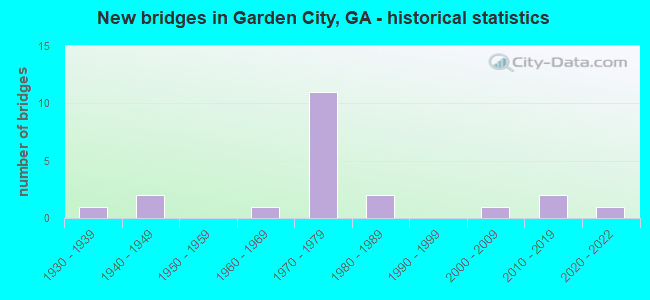
- New bridges - historical statistics
- 11930-1939
- 21940-1949
- 11960-1969
- 111970-1979
- 21980-1989
- 12000-2009
- 22010-2019
- 12020-2022

- Reconstructed bridges - Historical Statistics
- 31970-1979
- 31980-1989
- 11990-1999


- Bridge Condition - Deck
- 6.7%Very good
- 86.7%Good
- 6.7%Satisfactory

- Bridge Condition - Superstructure
- 66.7%Very good
- 33.3%Good

- Bridge Condition - Substructure
- 6.7%Very good
- 93.3%Good

- Bridge Condition - Channel
- 10.0%Excellent
- 30.0%Very good
- 60.0%Good

- Bridge Condition - Culverts
- 83.3%Good
- 16.7%Satisfactory
Find on map >> Show street view
Structure Number: 510024, Location: CITY OF GARDEN CITY (Lat: 32.097108, Lng: -81.138578), Route carried "on" structure: Interstate 516, Year Built: 1979, Status: Open, Structure Length: 4.33m (14.21ft), Average Daily Traffic: 38,330 (year 2011), Truck Traffic: 1%, Average Future Daily Traffic: 57,495 (year 2031), Design Load: HS 20+Mod, Features Intersected: CR 717 ALLEN BLVD.
Minimum Vertical Clearance: 30+ m (98+ ft), Kilometerpoint: 11.265, Lanes on structure: 2, Lanes under structure: 2, Base Highway Network: Yes, Owner: State Highway Agency, Approaching Roadway Width: 11.9m (39.0ft), Skew: 11 degrees, Material/Design: Steel, Design/Construction: Stringer/Multi-beam, Number Of Spans In Main Unit: 3, Length of Maximum Span: 21.9m (71.9ft), Curb-To-Curb Width: 12.3m (40.4ft), Out-to-Out Width: 13.4m (44.0ft)
Condition: Deck: Good, Superstructure: Very good, Substructure: Good, Operating Rating: 60.7 metric tons, Method Used To Determine Operating Rating: Load Factor (LF), Inventory Rating: 36.2 metric tons, Method Used To Determine Inventory Rating: Load Factor (LF), Structural Evaluation: Better than present minimum criteria, Deck Geometry: Better than present minimum criteria, Underclear: Equal to present minimum criteria, Approach Roadway Alignment: Equal to present desirable criteria, Designated Inspection Frequency: Every 24 months, Inspection Date: August 2020, Bridge Improvement Cost: $555,000, Roadway Improvement Cost: $55,000, Total Project Cost: $832,000, Deck Structure Type: Concrete Cast-file-Place
Find on map >> Show street view
Structure Number: 510025, Location: CITY OF GARDEN CITY (Lat: 32.096953, Lng: -81.138689), Route carried "on" structure: Interstate 516, Year Built: 1979, Status: Open, Structure Length: 4.33m (14.21ft), Average Daily Traffic: 38,330 (year 2011), Truck Traffic: 1%, Average Future Daily Traffic: 57,495 (year 2031), Design Load: HS 20+Mod, Features Intersected: CR 717 ALLEN BLVD.
Minimum Vertical Clearance: 30+ m (98+ ft), Kilometerpoint: 11.265, Lanes on structure: 2, Lanes under structure: 2, Base Highway Network: Yes, Owner: State Highway Agency, Approaching Roadway Width: 12.2m (40.0ft), Skew: 11 degrees, Material/Design: Steel, Design/Construction: Stringer/Multi-beam, Number Of Spans In Main Unit: 3, Length of Maximum Span: 21.9m (71.9ft), Curb-To-Curb Width: 12.3m (40.4ft), Out-to-Out Width: 13.4m (44.0ft)
Condition: Deck: Good, Superstructure: Very good, Substructure: Good, Operating Rating: 60.7 metric tons, Method Used To Determine Operating Rating: Load Factor (LF), Inventory Rating: 36.2 metric tons, Method Used To Determine Inventory Rating: Load Factor (LF), Structural Evaluation: Better than present minimum criteria, Deck Geometry: Better than present minimum criteria, Underclear: Equal to present minimum criteria, Approach Roadway Alignment: Equal to present desirable criteria, Designated Inspection Frequency: Every 24 months, Inspection Date: August 2020, Bridge Improvement Cost: $555,000, Roadway Improvement Cost: $55,000, Total Project Cost: $832,000, Deck Structure Type: Concrete Cast-file-Place
Find on map >> Show street view
Structure Number: 510026, Location: CITY OF GARDEN CITY (Lat: 32.097997, Lng: -81.140328), Route carried "on" structure: Interstate 516, Year Built: 1979, Status: Open, Structure Length: 15.15m (49.70ft), Average Daily Traffic: 38,330 (year 2011), Truck Traffic: 1%, Average Future Daily Traffic: 57,495 (year 2031), Design Load: HS 20+Mod, Features Intersected: CS 594-& CSX R/R.
Minimum Vertical Clearance: 30+ m (98+ ft), Kilometerpoint: 11.265, Lanes on structure: 3, Lanes under structure: 4, Base Highway Network: Yes, Owner: State Highway Agency, Approaching Roadway Width: 11.9m (39.0ft), Skew: 14 degrees, Material/Design: Steel, Design/Construction: Stringer/Multi-beam, Number Of Spans In Main Unit: 7, Length of Maximum Span: 27.1m (88.9ft), Curb-To-Curb Width: 12.3m (40.4ft), Out-to-Out Width: 13.4m (44.0ft)
Condition: Deck: Good, Superstructure: Good, Substructure: Good, Operating Rating: 58.9 metric tons, Method Used To Determine Operating Rating: Load Factor (LF), Inventory Rating: 32.6 metric tons, Method Used To Determine Inventory Rating: Load Factor (LF), Structural Evaluation: Better than present minimum criteria, Deck Geometry: Meets minimum limits, Underclear: Somewhat better than minimum adequacy, Approach Roadway Alignment: Equal to present desirable criteria, Designated Inspection Frequency: Every 24 months, Inspection Date: September 2020, Bridge Improvement Cost: $2,471,000, Roadway Improvement Cost: $247,000, Total Project Cost: $3,707,000, Deck Structure Type: Concrete Cast-file-Place
Find on map >> Show street view
Structure Number: 510027, Location: CITY OF GARDEN CITY (Lat: 32.097719, Lng: -81.140269), Route carried "on" structure: Interstate 516, Year Built: 1979, Status: Open, Structure Length: 15.36m (50.39ft), Average Daily Traffic: 38,330 (year 2011), Truck Traffic: 1%, Average Future Daily Traffic: 57,495 (year 2031), Design Load: HS 20+Mod, Features Intersected: CS 594-& CSX R/R.
Minimum Vertical Clearance: 30+ m (98+ ft), Kilometerpoint: 11.265, Lanes on structure: 2, Lanes under structure: 4, Base Highway Network: Yes, Owner: State Highway Agency, Approaching Roadway Width: 13.1m (43.0ft), Skew: 14 degrees, Material/Design: Steel, Design/Construction: Stringer/Multi-beam, Number Of Spans In Main Unit: 7, Length of Maximum Span: 28.7m (94.2ft), Curb-To-Curb Width: 13.3m (43.6ft), Out-to-Out Width: 14.1m (46.3ft)
Condition: Deck: Good, Superstructure: Very good, Substructure: Good, Operating Rating: 58.9 metric tons, Method Used To Determine Operating Rating: Load Factor (LF), Inventory Rating: 32.6 metric tons, Method Used To Determine Inventory Rating: Load Factor (LF), Structural Evaluation: Better than present minimum criteria, Deck Geometry: Superior to present desirable criteria, Underclear: Somewhat better than minimum adequacy, Approach Roadway Alignment: Equal to present desirable criteria, Designated Inspection Frequency: Every 24 months, Inspection Date: September 2020, Bridge Improvement Cost: $1,969,000, Roadway Improvement Cost: $197,000, Total Project Cost: $2,954,000, Deck Structure Type: Concrete Cast-file-Place
Find on map >> Show street view
Structure Number: 510028, Location: CITY OF GARDEN CITY (Lat: 32.099439, Lng: -81.143028), Route carried "on" structure: Interstate 516, Year Built: 1979, Status: Open, Structure Length: 4.39m (14.40ft), Average Daily Traffic: 38,330 (year 2011), Truck Traffic: 1%, Average Future Daily Traffic: 57,495 (year 2031), Design Load: HS 20+Mod, Features Intersected: SR 25
Minimum Vertical Clearance: 30+ m (98+ ft), Kilometerpoint: 11.265, Lanes on structure: 2, Lanes under structure: 4, Base Highway Network: Yes, Owner: State Highway Agency, Approaching Roadway Width: 12.2m (40.0ft), Skew: 11 degrees, Material/Design: Steel, Design/Construction: Stringer/Multi-beam, Number Of Spans In Main Unit: 3, Length of Maximum Span: 24.1m (79.1ft), Curb-To-Curb Width: 12.3m (40.4ft), Out-to-Out Width: 13.4m (44.0ft)
Condition: Deck: Good, Superstructure: Very good, Substructure: Good, Operating Rating: 58.0 metric tons, Method Used To Determine Operating Rating: Load Factor (LF), Inventory Rating: 34.4 metric tons, Method Used To Determine Inventory Rating: Load Factor (LF), Structural Evaluation: Better than present minimum criteria, Deck Geometry: Better than present minimum criteria, Underclear: Meets minimum limits, Approach Roadway Alignment: Equal to present desirable criteria, Designated Inspection Frequency: Every 24 months, Inspection Date: July 2020, Bridge Improvement Cost: $563,000, Roadway Improvement Cost: $56,000, Total Project Cost: $844,000, Deck Structure Type: Concrete Cast-file-Place
Find on map >> Show street view
Structure Number: 510029, Location: CITY OF GARDEN CITY (Lat: 32.099269, Lng: -81.143169), Route carried "on" structure: Interstate 516, Year Built: 1979, Status: Open, Structure Length: 4.39m (14.40ft), Average Daily Traffic: 38,330 (year 2011), Truck Traffic: 1%, Average Future Daily Traffic: 57,495 (year 2031), Design Load: HS 20+Mod, Features Intersected: SR 25
Minimum Vertical Clearance: 30+ m (98+ ft), Kilometerpoint: 11.265, Lanes on structure: 3, Lanes under structure: 4, Base Highway Network: Yes, Owner: State Highway Agency, Approaching Roadway Width: 11.6m (38.1ft), Skew: 11 degrees, Material/Design: Steel, Design/Construction: Stringer/Multi-beam, Number Of Spans In Main Unit: 3, Length of Maximum Span: 24.1m (79.1ft), Curb-To-Curb Width: 20.1m (65.9ft), Out-to-Out Width: 21.1m (69.2ft)
Condition: Deck: Good, Superstructure: Very good, Substructure: Good, Operating Rating: 59.8 metric tons, Method Used To Determine Operating Rating: Load Factor (LF), Inventory Rating: 35.3 metric tons, Method Used To Determine Inventory Rating: Load Factor (LF), Structural Evaluation: Better than present minimum criteria, Deck Geometry: Superior to present desirable criteria, Underclear: Somewhat better than minimum adequacy, Approach Roadway Alignment: Equal to present desirable criteria, Designated Inspection Frequency: Every 24 months, Inspection Date: July 2020, Bridge Improvement Cost: $716,000, Roadway Improvement Cost: $72,000, Total Project Cost: $1,074,000, Deck Structure Type: Concrete Cast-file-Place
Find on map >> Show street view
Structure Number: 51003, Location: CITY OF GARDEN CITY (Lat: 32.099861, Lng: -81.143136), Route carried "on" structure: Interstate 516, Year Built: 1979, Status: Open, Structure Length: 0.98m (3.22ft), Average Daily Traffic: 1,560 (year 2011), Truck Traffic: 1%, Average Future Daily Traffic: 2,340 (year 2031), Design Load: HS 20+Mod, Features Intersected: DUNDEE CANAL
Minimum Vertical Clearance: 30+ m (98+ ft), Kilometerpoint: 11.265, Lanes on structure: 5, Base Highway Network: Yes, Owner: State Highway Agency, Approaching Roadway Width: 33.8m (110.9ft), Skew: 10 degrees, Material/Design: Concrete, Design/Construction: Culvert, Number Of Spans In Main Unit: 3, Length of Maximum Span: 3.0m (9.8ft)
Condition: Channel: Good, Culverts: Good, Structural Evaluation: Better than present minimum criteria, Waterway Adequacy: Equal to present desirable criteria, Approach Roadway Alignment: Equal to present desirable criteria, Designated Inspection Frequency: Every 24 months, Inspection Date: July 2020, Bridge Improvement Cost: $227,000, Roadway Improvement Cost: $23,000, Total Project Cost: $341,000
Find on map >> Show street view
Structure Number: 510031, Location: N SECTION OF GARDEN CITY (Lat: 32.121250, Lng: -81.167689), Route carried "on" structure: State highway 21, Year Built: 1945, Year Reconstructed: 1979, Status: Open, Structure Length: 1.37m (4.49ft), Average Daily Traffic: 26,520 (year 2011), Truck Traffic: 11%, Average Future Daily Traffic: 39,780 (year 2031), Design Load: H 15, Features Intersected: PIPE MAKERS CANAL
Minimum Vertical Clearance: 30+ m (98+ ft), Kilometerpoint: 14.484, Lanes on structure: 4, Base Highway Network: Yes, Owner: State Highway Agency, Approaching Roadway Width: 22.9m (75.1ft), Skew: 10 degrees, Material/Design: Concrete, Design/Construction: Culvert, Number Of Spans In Main Unit: 4, Length of Maximum Span: 3.4m (11.2ft)
Condition: Channel: Good, Culverts: Good, Operating Rating: 55.3 metric tons, Method Used To Determine Operating Rating: Load Factor (LF), Inventory Rating: 33.5 metric tons, Method Used To Determine Inventory Rating: Load Factor (LF), Structural Evaluation: Better than present minimum criteria, Waterway Adequacy: Equal to present desirable criteria, Approach Roadway Alignment: Better than present minimum criteria, Designated Inspection Frequency: Every 24 months, Inspection Date: July 2020, Bridge Improvement Cost: $272,000, Roadway Improvement Cost: $27,000, Total Project Cost: $408,000
Find on map >> Show street view
Structure Number: 510039, Location: CITY OF GARDEN CITY (Lat: 32.098689, Lng: -81.143850), Route carried "on" structure: Ramp State highway 21, Year Built: 1979, Status: Open, Structure Length: 1.07m (3.51ft), Average Daily Traffic: 3,640 (year 2011), Truck Traffic: 1%, Average Future Daily Traffic: 5,460 (year 2031), Design Load: HS 20+Mod, Features Intersected: DUNDEE CANAL
Minimum Vertical Clearance: 30+ m (98+ ft), Kilometerpoint: 11.265, Lanes on structure: 1, Base Highway Network: Yes, Owner: State Highway Agency, Approaching Roadway Width: 7.3m (24.0ft), Skew: 2 degrees, Material/Design: Concrete, Design/Construction: Culvert, Number Of Spans In Main Unit: 3, Length of Maximum Span: 3.4m (11.2ft)
Condition: Channel: Good, Culverts: Good, Operating Rating: 59.8 metric tons, Method Used To Determine Operating Rating: Load Factor (LF), Inventory Rating: 36.2 metric tons, Method Used To Determine Inventory Rating: Load Factor (LF), Structural Evaluation: Better than present minimum criteria, Waterway Adequacy: Equal to present desirable criteria, Approach Roadway Alignment: Equal to present desirable criteria, Designated Inspection Frequency: Every 24 months, Inspection Date: July 2020, Bridge Improvement Cost: $99,000, Roadway Improvement Cost: $10,000, Total Project Cost: $149,000
Find on map >> Show street view
Structure Number: 51004, Location: CITY OF GARDEN CITY (Lat: 32.098339, Lng: -81.143978), Route carried "on" structure: Ramp State highway 21, Year Built: 1979, Status: Open, Structure Length: 1.04m (3.41ft), Average Daily Traffic: 4,450 (year 2011), Truck Traffic: 1%, Average Future Daily Traffic: 6,675 (year 2031), Design Load: HS 20+Mod, Features Intersected: DUNDEE CANAL
Minimum Vertical Clearance: 30+ m (98+ ft), Kilometerpoint: 11.265, Lanes on structure: 1, Base Highway Network: Yes, Owner: State Highway Agency, Approaching Roadway Width: 7.6m (24.9ft), Skew: 2 degrees, Material/Design: Concrete, Design/Construction: Culvert, Number Of Spans In Main Unit: 3, Length of Maximum Span: 3.4m (11.2ft)
Condition: Channel: Good, Culverts: Good, Operating Rating: 59.8 metric tons, Method Used To Determine Operating Rating: Load Factor (LF), Inventory Rating: 36.2 metric tons, Method Used To Determine Inventory Rating: Load Factor (LF), Structural Evaluation: Better than present minimum criteria, Waterway Adequacy: Equal to present desirable criteria, Approach Roadway Alignment: Equal to present desirable criteria, Designated Inspection Frequency: Every 24 months, Inspection Date: July 2020, Bridge Improvement Cost: $97,000, Roadway Improvement Cost: $10,000, Total Project Cost: $145,000
Find on map >> Show street view
Structure Number: 510044, Location: 5 MI SW OF SAVANNAH (Lat: 32.039319, Lng: -81.208219), Route carried "on" structure: US 17, Year Built: 1984, Year Reconstructed: 1991, Status: Open, Structure Length: 3.66m (12.01ft), Average Daily Traffic: 20,200 (year 2011), Truck Traffic: 7%, Average Future Daily Traffic: 30,300 (year 2031), Design Load: HS 20+Mod, Features Intersected: HARDIN CANAL, Facility Carried by Structure: OCEAN HIGHWAY
Minimum Vertical Clearance: 30+ m (98+ ft), Kilometerpoint: 11.265, Lanes on structure: 6, Base Highway Network: Yes, Owner: State Highway Agency, Approaching Roadway Width: 21.6m (70.9ft), Skew: 3 degrees, Material/Design: Prestressed concrete, Design/Construction: Stringer/Multi-beam, Number Of Spans In Main Unit: 3, Length of Maximum Span: 12.2m (40.0ft), Curb-To-Curb Width: 28.7m (94.2ft), Out-to-Out Width: 29.6m (97.1ft)
Condition: Deck: Good, Superstructure: Very good, Substructure: Good, Channel: Very good, Operating Rating: 72.5 metric tons, Method Used To Determine Operating Rating: Load Factor (LF), Inventory Rating: 43.5 metric tons, Method Used To Determine Inventory Rating: Load Factor (LF), Structural Evaluation: Better than present minimum criteria, Deck Geometry: Superior to present desirable criteria, Waterway Adequacy: Equal to present desirable criteria, Approach Roadway Alignment: Equal to present desirable criteria, Designated Inspection Frequency: Every 24 months, Inspection Date: June 2020, Bridge Improvement Cost: $980,000, Roadway Improvement Cost: $98,000, Total Project Cost: $1,471,000, Deck Structure Type: Concrete Cast-file-Place
Find on map >> Show street view
Structure Number: 510045, Location: 5 MI SW OF SAVANNAH (Lat: 32.039864, Lng: -81.203869), Route carried "on" structure: US 17, Year Built: 1984, Year Reconstructed: 1991, Status: Open, Structure Length: 7.68m (25.20ft), Average Daily Traffic: 19,520 (year 2011), Truck Traffic: 1%, Average Future Daily Traffic: 29,280 (year 2031), Design Load: HS 20+Mod, Features Intersected: SALT CREEK, Facility Carried by Structure: OCEAN HIGHWAY
Minimum Vertical Clearance: 30+ m (98+ ft), Kilometerpoint: 11.265, Lanes on structure: 5, Base Highway Network: Yes, Owner: State Highway Agency, Approaching Roadway Width: 21.6m (70.9ft), Material/Design: Prestressed concrete, Design/Construction: Stringer/Multi-beam, Number Of Spans In Main Unit: 7, Length of Maximum Span: 11.0m (36.1ft), Curb-To-Curb Width: 25.0m (82.0ft), Out-to-Out Width: 26.0m (85.3ft)
Condition: Deck: Good, Superstructure: Good, Substructure: Good, Channel: Very good, Operating Rating: 70.7 metric tons, Method Used To Determine Operating Rating: Load Factor (LF), Inventory Rating: 42.6 metric tons, Method Used To Determine Inventory Rating: Load Factor (LF), Structural Evaluation: Better than present minimum criteria, Deck Geometry: Superior to present desirable criteria, Waterway Adequacy: Equal to present minimum criteria, Approach Roadway Alignment: Equal to present desirable criteria, Designated Inspection Frequency: Every 24 months, Underwater Inspection Frequency: Every 60 months, Inspection Date: June 2020, Underwater Inspection Date: July 2019, Bridge Improvement Cost: $1,790,000, Roadway Improvement Cost: $179,000, Total Project Cost: $2,685,000, Deck Structure Type: Concrete Cast-file-Place
Find on map >> Show street view
Structure Number: 510051, Location: CITY OF GARDEN CITY (Lat: 32.101128, Lng: -81.142428), Route carried "on" structure: State highway 25, Year Built: 1977, Status: Open, Structure Length: 2.19m (7.19ft), Average Daily Traffic: 12,950 (year 2011), Truck Traffic: 1%, Average Future Daily Traffic: 19,425 (year 2031), Design Load: HS 20, Features Intersected: DUNDEE CANAL, Facility Carried by Structure: OCEAN HIGHWAY
Minimum Vertical Clearance: 30+ m (98+ ft), Kilometerpoint: 24.140, Lanes on structure: 5, Base Highway Network: Yes, Owner: State Highway Agency, Approaching Roadway Width: 15.8m (51.8ft), Skew: 4 degrees, Material/Design: Concrete, Design/Construction: Tee Beam, Number Of Spans In Main Unit: 2, Length of Maximum Span: 11.0m (36.1ft), Curb or Sidewalk Widths: Left: 2.1m (6.9ft), Right: 0.0m, Curb-To-Curb Width: 19.5m (64.0ft), Out-to-Out Width: 22.4m (73.5ft)
Condition: Deck: Good, Superstructure: Good, Substructure: Good, Channel: Very good, Operating Rating: 52.6 metric tons, Method Used To Determine Operating Rating: Load Factor (LF), Inventory Rating: 31.7 metric tons, Method Used To Determine Inventory Rating: Load Factor (LF), Structural Evaluation: Better than present minimum criteria, Deck Geometry: Meets minimum limits, Waterway Adequacy: Equal to present desirable criteria, Approach Roadway Alignment: Equal to present desirable criteria, Designated Inspection Frequency: Every 24 months, Inspection Date: July 2020, Bridge Improvement Cost: $511,000, Roadway Improvement Cost: $51,000, Total Project Cost: $767,000, Deck Structure Type: Concrete Cast-file-Place
Find on map >> Show street view
Structure Number: 51006, Location: IN GARDEN CITY (Lat: 32.090339, Lng: -81.153619), Route carried "on" structure: US 80, Year Built: 1938, Year Reconstructed: 1987, Status: Open, Structure Length: 12.22m (40.09ft), Average Daily Traffic: 17,370 (year 2011), Truck Traffic: 12%, Average Future Daily Traffic: 26,055 (year 2031), Design Load: HS 20+Mod, Features Intersected: CSX RAILROAD (641183P)
Minimum Vertical Clearance: 30+ m (98+ ft), Kilometerpoint: 17.703, Lanes on structure: 5, Base Highway Network: Yes, Owner: State Highway Agency, Approaching Roadway Width: 21.0m (68.9ft), Material/Design: Steel, Design/Construction: Stringer/Multi-beam, Number Of Spans In Main Unit: 5, Length of Maximum Span: 35.1m (115.2ft), Curb-To-Curb Width: 23.9m (78.4ft), Out-to-Out Width: 24.4m (80.1ft)
Condition: Deck: Satisfactory, Superstructure: Good, Substructure: Good, Operating Rating: 43.5 metric tons, Method Used To Determine Operating Rating: Load Factor (LF), Inventory Rating: 25.4 metric tons, Method Used To Determine Inventory Rating: Load Factor (LF), Structural Evaluation: Equal to present minimum criteria, Deck Geometry: Better than present minimum criteria, Underclear: Meets minimum limits, Approach Roadway Alignment: Equal to present desirable criteria, Designated Inspection Frequency: Every 24 months, Inspection Date: October 2020, Bridge Improvement Cost: $2,849,000, Roadway Improvement Cost: $285,000, Total Project Cost: $4,273,000, Deck Structure Type: Concrete Cast-file-Place
Find on map >> Show street view
Structure Number: 510061, Location: IN GARDEN CITY (Lat: 32.096539, Lng: -81.143389), Route carried "on" structure: US 80, Year Built: 1944, Year Reconstructed: 1997, Status: Open, Structure Length: 1.04m (3.41ft), Average Daily Traffic: 17,370 (year 2011), Truck Traffic: 12%, Average Future Daily Traffic: 26,055 (year 2031), Design Load: H 15, Features Intersected: DUNDEE CANAL
Minimum Vertical Clearance: 30+ m (98+ ft), Kilometerpoint: 19.312, Lanes on structure: 6, Base Highway Network: Yes, Owner: State Highway Agency, Approaching Roadway Width: 24.4m (80.1ft), Skew: 2 degrees, Material/Design: Concrete, Design/Construction: Culvert, Number Of Spans In Main Unit: 3, Length of Maximum Span: 3.4m (11.2ft), Curb or Sidewalk Widths: Left: 1.2m (3.9ft), Right: 1.2m (3.9ft)
Condition: Channel: Good, Culverts: Satisfactory, Operating Rating: 41.7 metric tons, Method Used To Determine Operating Rating: Field evaluation and documented engineering judgment, Inventory Rating: 24.4 metric tons, Method Used To Determine Inventory Rating: Field evaluation and documented engineering judgment, Structural Evaluation: Equal to present minimum criteria, Waterway Adequacy: Equal to present desirable criteria, Approach Roadway Alignment: Equal to present desirable criteria, Length Of Structure Improvement: 7.47m (24.51ft), Designated Inspection Frequency: Every 24 months, Inspection Date: July 2020, Bridge Improvement Cost: $278,000, Roadway Improvement Cost: $28,000, Total Project Cost: $417,000
Find on map >> Show street view
Structure Number: 510079, Location: 5 MI W OF SAVANNAH (Lat: 32.070158, Lng: -81.202689), Route carried "on" structure: State highway 307, Year Built: 1966, Year Reconstructed: 1978, Status: Open, Structure Length: 7.86m (25.79ft), Average Daily Traffic: 16,230 (year 2011), Truck Traffic: 23%, Average Future Daily Traffic: 24,345 (year 2031), Design Load: HS 20+Mod, Features Intersected: I-16 (SR 404)
Minimum Vertical Clearance: 30+ m (98+ ft), Kilometerpoint: 3.219, Lanes on structure: 5, Lanes under structure: 4, Base Highway Network: Yes, Owner: State Highway Agency, Approaching Roadway Width: 7.3m (24.0ft), Skew: 3 degrees, Material/Design: Steel continuous, Design/Construction: Stringer/Multi-beam, Number Of Spans In Main Unit: 4, Length of Maximum Span: 26.5m (86.9ft), Curb or Sidewalk Widths: Left: 1.2m (3.9ft), Right: 1.2m (3.9ft), Curb-To-Curb Width: 20.2m (66.3ft), Out-to-Out Width: 23.5m (77.1ft)
Condition: Deck: Good, Superstructure: Good, Substructure: Good, Operating Rating: 38.1 metric tons, Method Used To Determine Operating Rating: Load Factor (LF), Inventory Rating: 22.6 metric tons, Method Used To Determine Inventory Rating: Load Factor (LF), Structural Evaluation: Somewhat better than minimum adequacy, Deck Geometry: Somewhat better than minimum adequacy, Underclear: Meets minimum limits, Approach Roadway Alignment: Equal to present desirable criteria, Designated Inspection Frequency: Every 24 months, Inspection Date: June 2020, Bridge Improvement Cost: $1,833,000, Roadway Improvement Cost: $183,000, Total Project Cost: $2,749,000, Deck Structure Type: Concrete Cast-file-Place
Find on map >> Show street view
Structure Number: 51008, Location: 3 MI NW OF SAVANNAH (Lat: 32.106103, Lng: -81.195756), Route carried "on" structure: State highway 307, Year Built: 1971, Year Reconstructed: 1979, Status: Open, Structure Length: 1.01m (3.31ft), Average Daily Traffic: 17,160 (year 2011), Truck Traffic: 1%, Average Future Daily Traffic: 25,740 (year 2031), Design Load: HS 20+Mod, Features Intersected: PIPE MAKERS CANAL
Minimum Vertical Clearance: 30+ m (98+ ft), Kilometerpoint: 8.047, Lanes on structure: 5, Base Highway Network: Yes, Owner: State Highway Agency, Approaching Roadway Width: 20.1m (65.9ft), Skew: 1 degrees, Material/Design: Concrete, Design/Construction: Culvert, Number Of Spans In Main Unit: 3, Length of Maximum Span: 3.0m (9.8ft)
Condition: Channel: Good, Culverts: Good, Operating Rating: 55.3 metric tons, Method Used To Determine Operating Rating: Field evaluation and documented engineering judgment, Inventory Rating: 32.6 metric tons, Method Used To Determine Inventory Rating: Field evaluation and documented engineering judgment, Structural Evaluation: Better than present minimum criteria, Waterway Adequacy: Equal to present desirable criteria, Approach Roadway Alignment: Equal to present desirable criteria, Designated Inspection Frequency: Every 24 months, Inspection Date: August 2020, Bridge Improvement Cost: $234,000, Roadway Improvement Cost: $23,000, Total Project Cost: $352,000
Find on map >> Show street view
Structure Number: 515073, Location: 5.5 MILES NORTH OF SAV. (Lat: 32.132267, Lng: -81.153853), Route carried "on" structure: State highway 25, Year Built: 2003, Status: Open, Structure Length: 4.33m (14.21ft), Average Daily Traffic: 11,000 (year 2011), Truck Traffic: 1%, Average Future Daily Traffic: 16,500 (year 2031), Design Load: HS 20+Mod, Features Intersected: PORT ENTRANCE, Facility Carried by Structure: OCEAN HIGHWAY
Minimum Vertical Clearance: 30+ m (98+ ft), Kilometerpoint: 27.359, Lanes on structure: 2, Lanes under structure: 2, Base Highway Network: Yes, Owner: State Highway Agency, Approaching Roadway Width: 13.7m (44.9ft), Material/Design: Prestressed concrete, Design/Construction: Stringer/Multi-beam, Number Of Spans In Main Unit: 3, Length of Maximum Span: 21.3m (69.9ft), Curb-To-Curb Width: 13.6m (44.6ft), Out-to-Out Width: 14.5m (47.6ft)
Condition: Deck: Good, Superstructure: Very good, Substructure: Good, Operating Rating: 53.5 metric tons, Method Used To Determine Operating Rating: Allowable Stress (AS), Inventory Rating: 32.6 metric tons, Method Used To Determine Inventory Rating: Allowable Stress (AS), Structural Evaluation: Better than present minimum criteria, Deck Geometry: Superior to present desirable criteria, Underclear: Superior to present desirable criteria, Approach Roadway Alignment: Equal to present desirable criteria, Designated Inspection Frequency: Every 24 months, Inspection Date: August 2020, Bridge Improvement Cost: $555,000, Roadway Improvement Cost: $55,000, Total Project Cost: $832,000, Deck Structure Type: Concrete Cast-file-Place
Find on map >> Show street view
Structure Number: 51508, Location: 5 MI N OF SAVANNAH (Lat: 32.152708, Lng: -81.164025), Route carried "on" structure: State highway 25, Year Built: 2011, Status: Open, Structure Length: 5.39m (17.68ft), Average Daily Traffic: 7,000 (year 2008), Truck Traffic: 8%, Average Future Daily Traffic: 10,000 (year 2031), Design Load: HS 20+Mod, Features Intersected: NORFOLK SOUTHERN RAILROA, Facility Carried by Structure: OCEAN HIGHWAY
Minimum Vertical Clearance: 30+ m (98+ ft), Kilometerpoint: 30.578, Lanes on structure: 2, Base Highway Network: Yes, Owner: State Highway Agency, Approaching Roadway Width: 7.3m (24.0ft), Skew: 1 degrees, Material/Design: Prestressed concrete, Design/Construction: Stringer/Multi-beam, Number Of Spans In Main Unit: 2, Length of Maximum Span: 36.3m (119.1ft), Curb or Sidewalk Widths: Left: 1.8m (5.9ft), Right: 1.8m (5.9ft), Curb-To-Curb Width: 8.5m (27.9ft), Out-to-Out Width: 13.0m (42.7ft)
Condition: Deck: Good, Superstructure: Very good, Substructure: Good, Operating Rating: 41.7 metric tons, Method Used To Determine Operating Rating: Load Factor (LF), Inventory Rating: 27.2 metric tons, Method Used To Determine Inventory Rating: Load Factor (LF), Structural Evaluation: Equal to present minimum criteria, Deck Geometry: High priority of replacement, Underclear: Superior to present desirable criteria, Approach Roadway Alignment: Equal to present desirable criteria, Designated Inspection Frequency: Every 24 months, Inspection Date: September 2020, Bridge Improvement Cost: $692,000, Roadway Improvement Cost: $69,000, Total Project Cost: $1,037,000, Deck Structure Type: Concrete Cast-file-Place
Find on map >> Show street view
Structure Number: 515081, Location: 1.6 MILES SOUTH OF PORT W (Lat: 32.126628, Lng: -81.156067), Route carried "on" structure: State highway 307, Year Built: 2012, Status: Open, Structure Length: 28.93m (94.91ft), Average Daily Traffic: 11,000 (year 2010), Truck Traffic: 5%, Average Future Daily Traffic: 39,630 (year 2030), Design Load: HS 25 or greater, Features Intersected: PIPE MAKER CANAL / RR
Minimum Vertical Clearance: 30+ m (98+ ft), Kilometerpoint: 12.875, Lanes on structure: 4, Base Highway Network: Yes, Owner: State Highway Agency, Approaching Roadway Width: 11.0m (36.1ft), Skew: 20 degrees, Material/Design: Prestressed concrete, Design/Construction: Stringer/Multi-beam, Number Of Spans In Main Unit: 9, Length of Maximum Span: 36.0m (118.1ft), Curb-To-Curb Width: 21.9m (71.9ft), Out-to-Out Width: 24.2m (79.4ft)
Condition: Deck: Good, Superstructure: Very good, Substructure: Good, Operating Rating: 89.8 metric tons, Method Used To Determine Operating Rating: Load Factor (LF), Inventory Rating: 51.7 metric tons, Method Used To Determine Inventory Rating: Load Factor (LF), Structural Evaluation: Better than present minimum criteria, Deck Geometry: Superior to present desirable criteria, Approach Roadway Alignment: Equal to present minimum criteria, Designated Inspection Frequency: Every 24 months, Inspection Date: October 2020, Bridge Improvement Cost: $5,730,000, Roadway Improvement Cost: $573,000, Total Project Cost: $8,596,000, Deck Structure Type: Concrete Cast-file-Place
Find on map >> Show street view
Structure Number: 515113, Location: CITY OF GARDEN CITY (Lat: 32.123808, Lng: -81.150839), Route carried "on" structure: State highway 25, Year Built: 2020, Status: Open, Structure Length: 38.44m (126.12ft), Average Daily Traffic: 4,940 (year 2011), Truck Traffic: 13%, Average Future Daily Traffic: 7,410 (year 2031), Design Load: HL 93, Features Intersected: PIPEMAKER CANAL
Minimum Vertical Clearance: 30+ m (98+ ft), Kilometerpoint: 25.750, Lanes on structure: 2, Base Highway Network: Yes, Owner: State Highway Agency, Approaching Roadway Width: 7.0m (23.0ft), Material/Design: Prestressed concrete, Design/Construction: Stringer/Multi-beam, Number Of Spans In Main Unit: 15, Length of Maximum Span: 45.7m (149.9ft), Curb or Sidewalk Widths: Left: 0.0m, Right: 1.5m (4.9ft), Curb-To-Curb Width: 11.0m (36.1ft), Out-to-Out Width: 13.6m (44.6ft)
Condition: Deck: Very good, Superstructure: Very good, Substructure: Very good, Channel: Excellent, Operating Rating: 61.6 metric tons, Method Used To Determine Operating Rating: Load Factor (LF), Inventory Rating: 37.1 metric tons, Method Used To Determine Inventory Rating: Load Factor (LF), Structural Evaluation: Equal to present desirable criteria, Deck Geometry: Somewhat better than minimum adequacy, Waterway Adequacy: Superior to present desirable criteria, Approach Roadway Alignment: Equal to present desirable criteria, Length Of Structure Improvement: 46.12m (151.31ft), Designated Inspection Frequency: Every 24 months, Inspection Date: July 2020, Bridge Improvement Cost: $111,976,000, Roadway Improvement Cost: $11,197,000, Total Project Cost: $167,965,000 ( Estimate for 2020), Deck Structure Type: Concrete Cast-file-Place
Find on map >> Show street view
Structure Number: 510024, Location: CITY OF GARDEN CITY (Lat: 32.097108, Lng: -81.138578), Route carried "under" structure: City street 717, Structure Length: 0. m, Average Daily Traffic: 1,640 (year 1999), Truck Traffic: 1%, Features Intersected: SR 421 NBL (I-516), Facility Carried by Structure: I-516 (NBL)
Minimum Vertical Clearance: 5.94m (19.49ft), Kilometerpoint: 0.000, Lanes on structure: 2, Length of Maximum Span: 0.0m
Find on map >> Show street view
Structure Number: 510025, Location: CITY OF GARDEN CITY (Lat: 32.096953, Lng: -81.138689), Route carried "under" structure: City street 717, Structure Length: 0. m, Average Daily Traffic: 1,640 (year 1999), Truck Traffic: 1%, Features Intersected: SR 421 SBL (I-516), Facility Carried by Structure: I-516 (SBL)
Minimum Vertical Clearance: 5.63m (18.47ft), Kilometerpoint: 0.000, Lanes on structure: 2, Length of Maximum Span: 0.0m
Find on map >> Show street view
Structure Number: 510026, Location: CITY OF GARDEN CITY (Lat: 32.097997, Lng: -81.140328), Route carried "under" structure: City street 594, Structure Length: 0. m, Average Daily Traffic: 9,360 (year 1999), Truck Traffic: 1%, Features Intersected: SR 421 NBL (I-516), Facility Carried by Structure: I-516 (NBL)
Minimum Vertical Clearance: 5.48m (17.98ft), Kilometerpoint: 0.000, Lanes on structure: 3, Length of Maximum Span: 0.0m
Find on map >> Show street view
Structure Number: 510027, Location: CITY OF GARDEN CITY (Lat: 32.097719, Lng: -81.140269), Route carried "under" structure: City street 594, Structure Length: 0. m, Average Daily Traffic: 9,360 (year 1999), Truck Traffic: 1%, Features Intersected: SR 421 SBL (I-516), Facility Carried by Structure: I-516 (SBL)
Minimum Vertical Clearance: 5.66m (18.57ft), Kilometerpoint: 0.000, Lanes on structure: 2, Length of Maximum Span: 0.0m
Find on map >> Show street view
Structure Number: 510028, Location: CITY OF GARDEN CITY (Lat: 32.099439, Lng: -81.143028), Route carried "under" structure: State highway 25, Structure Length: 0. m, Average Daily Traffic: 14,140 (year 1999), Truck Traffic: 1%, Features Intersected: SR 421 NBL (I-516), Facility Carried by Structure: I-516 (NBL)
Minimum Vertical Clearance: 5.38m (17.65ft), Kilometerpoint: 24.140, Lanes on structure: 2, Length of Maximum Span: 0.0m
Find on map >> Show street view
Structure Number: 510029, Location: CITY OF GARDEN CITY (Lat: 32.099269, Lng: -81.143169), Route carried "under" structure: State highway 25, Structure Length: 0. m, Average Daily Traffic: 14,300 (year 1999), Truck Traffic: 1%, Features Intersected: SR 421 SBL (I-516), Facility Carried by Structure: I-516 (SBL)
Minimum Vertical Clearance: 5.58m (18.31ft), Kilometerpoint: 24.140, Lanes on structure: 3, Length of Maximum Span: 0.0m
Find on map >> Show street view
Structure Number: 510079, Location: 5 MI W OF SAVANNAH (Lat: 32.070158, Lng: -81.202689), Route carried "under" structure: Interstate 16, Structure Length: 0. m, Average Daily Traffic: 37,400 (year 1999), Truck Traffic: 1%, Features Intersected: SR 307, Facility Carried by Structure: SR 307
Minimum Vertical Clearance: 5.18m (16.99ft), Kilometerpoint: 257.495, Lanes on structure: 5, Length of Maximum Span: 0.0m
Find on map >> Show street view
Structure Number: 510154, Location: N SECTION OF GARDEN CTY (Lat: 32.111297, Lng: -81.161028), Route carried "under" structure: State highway 21, Structure Length: 0. m, Average Daily Traffic: 32,670 (year 2011), Truck Traffic: 1%, Features Intersected: SR 21, Facility Carried by Structure: PED BRIDGE
Minimum Vertical Clearance: 6.12m (20.08ft), Kilometerpoint: 14.484, Length of Maximum Span: 0.0m
Find on map >> Show street view
Structure Number: 515073, Location: 5.5 MILES NORTH OF SAV. (Lat: 32.132267, Lng: -81.153853), Route carried "under" structure: Other road 25, Structure Length: 0. m, Average Daily Traffic: 4,440 (year 2003), Truck Traffic: 5%, Features Intersected: SR 25 OCEAN HIG, Facility Carried by Structure: OCEAN HIGHWAY
Minimum Vertical Clearance: 5.53m (18.14ft), Kilometerpoint: 0.000, Lanes on structure: 2, Length of Maximum Span: 0.0m
Find on map >> Show street view
Structure Number: 515107, Location: 1 MI N OF PORT WENTWORTH (Lat: 32.220267, Lng: -81.196617), Route carried "under" structure: State highway 21, Structure Length: 0. m, Average Daily Traffic: 32,670 (year 2011), Truck Traffic: 1%, Features Intersected: SR 21, Facility Carried by Structure: PED BRIDGE
Minimum Vertical Clearance: 5.68m (18.64ft), Kilometerpoint: 26.715, Length of Maximum Span: 0.0m