Bridge Statistics for Front Royal, Virginia (VA)
Condition, Traffic, Stress, Structural Evaluation, Project Costs
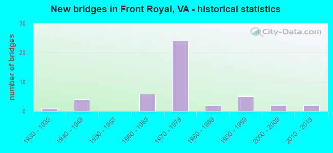
- New bridges - historical statistics
- 11930-1939
- 41940-1949
- 61960-1969
- 241970-1979
- 21980-1989
- 51990-1999
- 22000-2009
- 22010-2019

- Reconstructed bridges - Historical Statistics
- 11970-1979
- 11980-1989
- 01990-1999
- 12000-2009


- Bridge Condition - Deck
- 22.2%Very good
- 33.3%Good
- 37.0%Satisfactory
- 7.4%Fair

- Bridge Condition - Superstructure
- 22.2%Very good
- 22.2%Good
- 33.3%Satisfactory
- 22.2%Fair

- Bridge Condition - Substructure
- 3.7%Very good
- 40.7%Good
- 37.0%Satisfactory
- 18.5%Fair

- Bridge Condition - Channel
- 32.1%Very good
- 39.3%Good
- 21.4%Satisfactory
- 3.6%Fair
- 3.6%Poor

- Bridge Condition - Culverts
- 10.0%Very good
- 60.0%Good
- 20.0%Satisfactory
- 10.0%Fair
Find on map >> Show street view
Structure Number: 18703, Location: 6.30 FREDRCK-0.25 340/522 (Lat: 38.963033, Lng: -78.196525), Route carried "on" structure: Interstate 66, Year Built: 1971, Status: Open, Structure Length: 10.70m (35.10ft), Average Daily Traffic: 15,448 (year 2020), Truck Traffic: 15%, Average Future Daily Traffic: 21,627 (year 2040), Design Load: HS 20+Mod, Features Intersected: CROOKED RUN
Minimum Vertical Clearance: 30+ m (98+ ft), Kilometerpoint: 10.475, Lanes on structure: 3, Base Highway Network: Yes, Owner: State Highway Agency, Approaching Roadway Width: 13.4m (44.0ft), Material/Design: Steel, Design/Construction: Stringer/Multi-beam, Number Of Spans In Main Unit: 3, Length of Maximum Span: 35.7m (117.1ft), Curb-To-Curb Width: 15.8m (51.8ft), Out-to-Out Width: 17.1m (56.1ft)
Condition: Deck: Satisfactory, Superstructure: Satisfactory, Substructure: Fair, Channel: Good, Operating Rating: 79.8 metric tons, Method Used To Determine Operating Rating: Load and Resistance Factor (LRFR), Inventory Rating: 61.7 metric tons, Method Used To Determine Inventory Rating: Load and Resistance Factor (LRFR), Structural Evaluation: Somewhat better than minimum adequacy, Deck Geometry: Somewhat better than minimum adequacy, Waterway Adequacy: Equal to present desirable criteria, Approach Roadway Alignment: Equal to present desirable criteria, Designated Inspection Frequency: Every 24 months, Inspection Date: June 2021, Bridge Improvement Cost: $63,000, Roadway Improvement Cost: $1,000, Total Project Cost: $70,000, Deck Structure Type: Concrete Cast-file-Place, Wearing Surface/Protective System: Wearing Surface: Epoxy Overlay
Find on map >> Show street view
Structure Number: 18704, Location: 6.20 FREDRCK-0.25 340/522 (Lat: 38.963333, Lng: -78.196231), Route carried "on" structure: Interstate 66, Year Built: 1971, Status: Open, Structure Length: 10.70m (35.10ft), Average Daily Traffic: 15,115 (year 2020), Truck Traffic: 15%, Average Future Daily Traffic: 21,161 (year 2040), Design Load: HS 20+Mod, Features Intersected: CROOKED RUN
Minimum Vertical Clearance: 30+ m (98+ ft), Kilometerpoint: 10.748, Lanes on structure: 3, Base Highway Network: Yes, Owner: State Highway Agency, Approaching Roadway Width: 13.4m (44.0ft), Material/Design: Steel, Design/Construction: Stringer/Multi-beam, Number Of Spans In Main Unit: 3, Length of Maximum Span: 35.7m (117.1ft), Curb-To-Curb Width: 15.8m (51.8ft), Out-to-Out Width: 17.1m (56.1ft)
Condition: Deck: Satisfactory, Superstructure: Satisfactory, Substructure: Fair, Channel: Good, Operating Rating: 79.8 metric tons, Method Used To Determine Operating Rating: Load and Resistance Factor (LRFR), Inventory Rating: 59.9 metric tons, Method Used To Determine Inventory Rating: Load and Resistance Factor (LRFR), Structural Evaluation: Somewhat better than minimum adequacy, Deck Geometry: Somewhat better than minimum adequacy, Waterway Adequacy: Equal to present desirable criteria, Approach Roadway Alignment: Better than present minimum criteria, Designated Inspection Frequency: Every 24 months, Inspection Date: June 2021, Bridge Improvement Cost: $63,000, Roadway Improvement Cost: $1,000, Total Project Cost: $70,000, Deck Structure Type: Concrete Cast-file-Place, Wearing Surface/Protective System: Wearing Surface: Epoxy Overlay
Find on map >> Show street view
Structure Number: 18705, Location: 6.45 FREDERICK-6.19 TO 79 (Lat: 38.960967, Lng: -78.193206), Route carried "on" structure: Interstate 66, Year Built: 1971, Status: Open, Structure Length: 6.83m (22.41ft), Average Daily Traffic: 14,342 (year 2020), Truck Traffic: 15%, Average Future Daily Traffic: 20,079 (year 2040), Design Load: HS 20+Mod, Features Intersected: ROUTES 522 & 340
Minimum Vertical Clearance: 30+ m (98+ ft), Kilometerpoint: 10.877, Lanes on structure: 2, Lanes under structure: 6, Base Highway Network: Yes, Owner: State Highway Agency, Approaching Roadway Width: 13.4m (44.0ft), Skew: 1 degrees, Material/Design: Steel, Design/Construction: Stringer/Multi-beam, Number Of Spans In Main Unit: 4, Length of Maximum Span: 22.6m (74.1ft), Curb-To-Curb Width: 12.2m (40.0ft), Out-to-Out Width: 13.4m (44.0ft)
Condition: Deck: Good, Superstructure: Satisfactory, Substructure: Good, Operating Rating: 56.2 metric tons, Method Used To Determine Operating Rating: Load and Resistance Factor (LRFR), Inventory Rating: 43.5 metric tons, Method Used To Determine Inventory Rating: Load and Resistance Factor (LRFR), Structural Evaluation: Equal to present minimum criteria, Deck Geometry: Better than present minimum criteria, Underclear: Equal to present minimum criteria, Approach Roadway Alignment: Equal to present desirable criteria, Designated Inspection Frequency: Every 24 months, Inspection Date: March 2021, Bridge Improvement Cost: $76,000, Total Project Cost: $78,000, Deck Structure Type: Concrete Cast-file-Place, Wearing Surface/Protective System: Wearing Surface: Epoxy Overlay
Find on map >> Show street view
Structure Number: 18707, Location: 6.45 FREDERICK-6.19 TO 79 (Lat: 38.961233, Lng: -78.192989), Route carried "on" structure: Interstate 66, Year Built: 1971, Status: Open, Structure Length: 6.83m (22.41ft), Average Daily Traffic: 15,115 (year 2020), Truck Traffic: 15%, Average Future Daily Traffic: 21,161 (year 2040), Design Load: HS 20+Mod, Features Intersected: ROUTES 522 & 340
Minimum Vertical Clearance: 30+ m (98+ ft), Kilometerpoint: 11.118, Lanes on structure: 2, Lanes under structure: 6, Base Highway Network: Yes, Owner: State Highway Agency, Approaching Roadway Width: 13.4m (44.0ft), Skew: 1 degrees, Material/Design: Steel, Design/Construction: Stringer/Multi-beam, Number Of Spans In Main Unit: 4, Length of Maximum Span: 22.6m (74.1ft), Curb-To-Curb Width: 15.8m (51.8ft), Out-to-Out Width: 17.1m (56.1ft)
Condition: Deck: Good, Superstructure: Satisfactory, Substructure: Fair, Operating Rating: 59.0 metric tons, Method Used To Determine Operating Rating: Load and Resistance Factor (LRFR), Inventory Rating: 45.4 metric tons, Method Used To Determine Inventory Rating: Load and Resistance Factor (LRFR), Structural Evaluation: Somewhat better than minimum adequacy, Deck Geometry: Superior to present desirable criteria, Underclear: Equal to present minimum criteria, Approach Roadway Alignment: Equal to present desirable criteria, Designated Inspection Frequency: Every 24 months, Inspection Date: March 2021, Bridge Improvement Cost: $99,000, Total Project Cost: $102,000, Deck Structure Type: Concrete Cast-file-Place, Wearing Surface/Protective System: Wearing Surface: Latex Concrete
Find on map >> Show street view
Structure Number: 1871, Location: 1.90 TO 340 - 4.3 TO 79 (Lat: 38.948953, Lng: -78.161308), Route carried "on" structure: Interstate 66, Year Built: 1974, Status: Open, Structure Length: 0.64m (2.10ft), Average Daily Traffic: 14,417 (year 2020), Truck Traffic: 15%, Average Future Daily Traffic: 20,184 (year 2040), Design Load: HS 20+Mod, Features Intersected: TRIB SHENANDOAH RIVER
Minimum Vertical Clearance: 30+ m (98+ ft), Kilometerpoint: 14.272, Lanes on structure: 2, Base Highway Network: Yes, Owner: State Highway Agency, Approaching Roadway Width: 13.4m (44.0ft), Skew: 3 degrees, Material/Design: Concrete, Design/Construction: Culvert, Number Of Spans In Main Unit: 2, Length of Maximum Span: 2.4m (7.9ft)
Condition: Channel: Very good, Culverts: Good, Operating Rating: 89.8 metric tons, Method Used To Determine Operating Rating: Field evaluation and documented engineering judgment, Inventory Rating: 88.9 metric tons, Method Used To Determine Inventory Rating: Field evaluation and documented engineering judgment, Structural Evaluation: Better than present minimum criteria, Waterway Adequacy: Equal to present minimum criteria, Approach Roadway Alignment: Equal to present desirable criteria, Designated Inspection Frequency: Every 24 months, Inspection Date: June 2021
Find on map >> Show street view
Structure Number: 18712, Location: 1.90 TO 340 - 4.30 TO 79 (Lat: 38.948486, Lng: -78.162100), Route carried "on" structure: Interstate 66, Year Built: 1974, Status: Open, Structure Length: 0.61m (2.00ft), Average Daily Traffic: 14,342 (year 2020), Truck Traffic: 15%, Average Future Daily Traffic: 20,079 (year 2040), Design Load: HS 20+Mod, Features Intersected: TRIB SHENANDOAH RIVER
Minimum Vertical Clearance: 30+ m (98+ ft), Kilometerpoint: 13.950, Lanes on structure: 2, Base Highway Network: Yes, Owner: State Highway Agency, Approaching Roadway Width: 13.4m (44.0ft), Skew: 3 degrees, Material/Design: Concrete, Design/Construction: Culvert, Number Of Spans In Main Unit: 2, Length of Maximum Span: 2.4m (7.9ft)
Condition: Channel: Good, Culverts: Satisfactory, Operating Rating: 89.8 metric tons, Method Used To Determine Operating Rating: Field evaluation and documented engineering judgment, Inventory Rating: 88.9 metric tons, Method Used To Determine Inventory Rating: Field evaluation and documented engineering judgment, Structural Evaluation: Equal to present minimum criteria, Waterway Adequacy: Equal to present minimum criteria, Approach Roadway Alignment: Equal to present desirable criteria, Designated Inspection Frequency: Every 24 months, Inspection Date: June 2021
Find on map >> Show street view
Structure Number: 18713, Location: 1.20 340/522 - 5.02 TO 79 (Lat: 38.950947, Lng: -78.174172), Route carried "on" structure: Interstate 66, Year Built: 1974, Status: Open, Structure Length: 3.05m (10.01ft), Average Daily Traffic: 14,342 (year 2020), Truck Traffic: 19%, Average Future Daily Traffic: 20,079 (year 2040), Design Load: HS 20+Mod, Features Intersected: MARYS SHADY LN (PRIVATE)
Minimum Vertical Clearance: 30+ m (98+ ft), Kilometerpoint: 12.872, Lanes on structure: 2, Lanes under structure: 2, Base Highway Network: Yes, Owner: State Highway Agency, Approaching Roadway Width: 13.4m (44.0ft), Material/Design: Prestressed concrete, Design/Construction: Stringer/Multi-beam, Number Of Spans In Main Unit: 3, Length of Maximum Span: 11.6m (38.1ft), Curb-To-Curb Width: 12.2m (40.0ft), Out-to-Out Width: 13.4m (44.0ft)
Condition: Deck: Good, Superstructure: Good, Substructure: Fair, Operating Rating: 78.0 metric tons, Method Used To Determine Operating Rating: Load and Resistance Factor (LRFR), Inventory Rating: 59.9 metric tons, Method Used To Determine Inventory Rating: Load and Resistance Factor (LRFR), Structural Evaluation: Somewhat better than minimum adequacy, Deck Geometry: Better than present minimum criteria, Underclear: High priority of corrective action, Approach Roadway Alignment: Equal to present desirable criteria, Designated Inspection Frequency: Every 24 months, Inspection Date: August 2021, Deck Structure Type: Concrete Cast-file-Place, Wearing Surface/Protective System: Wearing Surface: Epoxy Overlay
Find on map >> Show street view
Structure Number: 18715, Location: 1.20 340/522 - 5.02 TO 79 (Lat: 38.951386, Lng: -78.174047), Route carried "on" structure: Interstate 66, Year Built: 1974, Status: Open, Structure Length: 3.47m (11.38ft), Average Daily Traffic: 14,417 (year 2020), Truck Traffic: 19%, Average Future Daily Traffic: 20,184 (year 2040), Design Load: HS 20+Mod, Features Intersected: MARYS SHADY LN (PRIVATE)
Minimum Vertical Clearance: 30+ m (98+ ft), Kilometerpoint: 13.146, Lanes on structure: 2, Lanes under structure: 2, Base Highway Network: Yes, Owner: State Highway Agency, Approaching Roadway Width: 13.4m (44.0ft), Material/Design: Prestressed concrete, Design/Construction: Stringer/Multi-beam, Number Of Spans In Main Unit: 3, Length of Maximum Span: 11.6m (38.1ft), Curb-To-Curb Width: 12.2m (40.0ft), Out-to-Out Width: 13.4m (44.0ft)
Condition: Deck: Good, Superstructure: Good, Substructure: Satisfactory, Operating Rating: 76.2 metric tons, Method Used To Determine Operating Rating: Load and Resistance Factor (LRFR), Inventory Rating: 58.1 metric tons, Method Used To Determine Inventory Rating: Load and Resistance Factor (LRFR), Structural Evaluation: Equal to present minimum criteria, Deck Geometry: Better than present minimum criteria, Underclear: High priority of corrective action, Approach Roadway Alignment: Equal to present desirable criteria, Designated Inspection Frequency: Every 24 months, Inspection Date: August 2021, Deck Structure Type: Concrete Cast-file-Place, Wearing Surface/Protective System: Wearing Surface: Latex Concrete
Find on map >> Show street view
Structure Number: 18717, Location: 3.80 340/522 - 2.39 TO 79 (Lat: 38.937414, Lng: -78.130661), Route carried "on" structure: Interstate 66, Year Built: 1974, Status: Open, Structure Length: 4.69m (15.39ft), Average Daily Traffic: 14,342 (year 2020), Truck Traffic: 15%, Average Future Daily Traffic: 20,079 (year 2040), Design Load: HS 20+Mod, Features Intersected: HAPPY CREEK RD (RT 624)
Minimum Vertical Clearance: 30+ m (98+ ft), Kilometerpoint: 16.991, Lanes on structure: 2, Lanes under structure: 2, Base Highway Network: Yes, Owner: State Highway Agency, Approaching Roadway Width: 13.4m (44.0ft), Material/Design: Steel, Design/Construction: Stringer/Multi-beam, Number Of Spans In Main Unit: 3, Length of Maximum Span: 16.5m (54.1ft), Curb-To-Curb Width: 12.2m (40.0ft), Out-to-Out Width: 13.4m (44.0ft)
Condition: Deck: Satisfactory, Superstructure: Fair, Substructure: Satisfactory, Operating Rating: 53.5 metric tons, Method Used To Determine Operating Rating: Load and Resistance Factor (LRFR), Inventory Rating: 41.7 metric tons, Method Used To Determine Inventory Rating: Load and Resistance Factor (LRFR), Structural Evaluation: Somewhat better than minimum adequacy, Deck Geometry: Better than present minimum criteria, Underclear: Equal to present minimum criteria, Approach Roadway Alignment: Better than present minimum criteria, Designated Inspection Frequency: Every 24 months, Inspection Date: August 2021, Deck Structure Type: Concrete Cast-file-Place, Wearing Surface/Protective System: Wearing Surface: Epoxy Overlay
Find on map >> Show street view
Structure Number: 18719, Location: 3.80 340/522 - 2.39 TO 79 (Lat: 38.937675, Lng: -78.130119), Route carried "on" structure: Interstate 66, Year Built: 1974, Status: Open, Structure Length: 4.69m (15.39ft), Average Daily Traffic: 14,417 (year 2020), Truck Traffic: 15%, Average Future Daily Traffic: 20,184 (year 2040), Design Load: HS 20+Mod, Features Intersected: HAPPY CREEK RD (RT 624)
Minimum Vertical Clearance: 30+ m (98+ ft), Kilometerpoint: 17.265, Lanes on structure: 2, Lanes under structure: 2, Base Highway Network: Yes, Owner: State Highway Agency, Approaching Roadway Width: 13.4m (44.0ft), Material/Design: Steel, Design/Construction: Stringer/Multi-beam, Number Of Spans In Main Unit: 3, Length of Maximum Span: 16.5m (54.1ft), Curb-To-Curb Width: 12.2m (40.0ft), Out-to-Out Width: 13.4m (44.0ft)
Condition: Deck: Satisfactory, Superstructure: Fair, Substructure: Satisfactory, Operating Rating: 53.5 metric tons, Method Used To Determine Operating Rating: Load and Resistance Factor (LRFR), Inventory Rating: 40.8 metric tons, Method Used To Determine Inventory Rating: Load and Resistance Factor (LRFR), Structural Evaluation: Somewhat better than minimum adequacy, Deck Geometry: Better than present minimum criteria, Underclear: Equal to present minimum criteria, Approach Roadway Alignment: Better than present minimum criteria, Designated Inspection Frequency: Every 24 months, Inspection Date: August 2021, Deck Structure Type: Concrete Cast-file-Place, Wearing Surface/Protective System: Wearing Surface: Epoxy Overlay
Find on map >> Show street view
Structure Number: 18721, Location: 0.55 TO 340 - 5.34 TO 79 (Lat: 38.956869, Lng: -78.186883), Route carried "on" structure: Interstate 66, Year Built: 1976, Status: Open, Structure Length: 38.01m (124.70ft), Average Daily Traffic: 14,342 (year 2020), Truck Traffic: 15%, Average Future Daily Traffic: 20,079 (year 2040), Design Load: HS 20+Mod, Features Intersected: NS RWY SHEN RV & CK RUN
Minimum Vertical Clearance: 30+ m (98+ ft), Kilometerpoint: 11.553, Lanes on structure: 2, Base Highway Network: Yes, Owner: State Highway Agency, Approaching Roadway Width: 13.4m (44.0ft), Material/Design: Steel continuous, Design/Construction: Stringer/Multi-beam, Number Of Spans In Main Unit: 3, Number Of Approach Spans: 10, Length of Maximum Span: 48.8m (160.1ft), Curb-To-Curb Width: 12.2m (40.0ft), Out-to-Out Width: 13.4m (44.0ft)
Condition: Deck: Good, Superstructure: Satisfactory, Substructure: Satisfactory, Channel: Very good, Operating Rating: 49.0 metric tons, Method Used To Determine Operating Rating: Load and Resistance Factor (LRFR), Inventory Rating: 37.2 metric tons, Method Used To Determine Inventory Rating: Load and Resistance Factor (LRFR), Structural Evaluation: Equal to present minimum criteria, Deck Geometry: Better than present minimum criteria, Underclear: Equal to present minimum criteria, Waterway Adequacy: Equal to present minimum criteria, Approach Roadway Alignment: Equal to present desirable criteria, Length Of Structure Improvement: 38.01m (124.70ft), Designated Inspection Frequency: Every 24 months, Underwater Inspection Frequency: Every 60 months, Inspection Date: August 2021, Underwater Inspection Date: July 2019, Bridge Improvement Cost: $555,000, Roadway Improvement Cost: $10,000, Total Project Cost: $566,000, Deck Structure Type: Concrete Cast-file-Place, Wearing Surface/Protective System: Wearing Surface: Latex Concrete
Find on map >> Show street view
Structure Number: 18722, Location: 0.55 TO 340 - 5.34 TO 79 (Lat: 38.957061, Lng: -78.186683), Route carried "on" structure: Interstate 66, Year Built: 1976, Status: Open, Structure Length: 38.01m (124.70ft), Average Daily Traffic: 14,417 (year 2020), Truck Traffic: 15%, Average Future Daily Traffic: 20,184 (year 2040), Design Load: HS 20+Mod, Features Intersected: NS RWY SHEN RV & CK RUN
Minimum Vertical Clearance: 30+ m (98+ ft), Kilometerpoint: 11.826, Lanes on structure: 2, Base Highway Network: Yes, Owner: State Highway Agency, Approaching Roadway Width: 13.4m (44.0ft), Material/Design: Steel continuous, Design/Construction: Stringer/Multi-beam, Number Of Spans In Main Unit: 3, Number Of Approach Spans: 10, Length of Maximum Span: 48.8m (160.1ft), Curb-To-Curb Width: 12.2m (40.0ft), Out-to-Out Width: 13.4m (44.0ft)
Condition: Deck: Good, Superstructure: Satisfactory, Substructure: Satisfactory, Channel: Good, Operating Rating: 51.7 metric tons, Method Used To Determine Operating Rating: Load and Resistance Factor (LRFR), Inventory Rating: 39.0 metric tons, Method Used To Determine Inventory Rating: Load and Resistance Factor (LRFR), Structural Evaluation: Equal to present minimum criteria, Deck Geometry: Better than present minimum criteria, Underclear: Somewhat better than minimum adequacy, Waterway Adequacy: Equal to present desirable criteria, Approach Roadway Alignment: Better than present minimum criteria, Designated Inspection Frequency: Every 24 months, Underwater Inspection Frequency: Every 60 months, Inspection Date: September 2021, Underwater Inspection Date: July 2019, Deck Structure Type: Concrete Cast-file-Place, Wearing Surface/Protective System: Wearing Surface: Latex Concrete
Find on map >> Show street view
Structure Number: 18752, Location: 0.25 RT 55 - 0.05 RT 637 (Lat: 38.948758, Lng: -78.199761), Route carried "on" structure: US 340, Year Built: 1941, Year Reconstructed: 2009, Status: Open, Structure Length: 32.64m (107.09ft), Average Daily Traffic: 27,435 (year 2020), Truck Traffic: 4%, Average Future Daily Traffic: 38,409 (year 2040), Design Load: HS 20+Mod, Features Intersected: N F SHEN RIVER & NS RWY, Facility Carried by Structure: N SHENANDOAH AVE
Minimum Vertical Clearance: 30+ m (98+ ft), Kilometerpoint: 155.928, Lanes on structure: 5, Owner: State Highway Agency, Approaching Roadway Width: 18.0m (59.1ft), Skew: 2 degrees, Material/Design: Steel continuous, Design/Construction: Stringer/Multi-beam, Number Of Spans In Main Unit: 9, Number Of Approach Spans: 2, Length of Maximum Span: 38.7m (127.0ft), Curb or Sidewalk Widths: Left: 1.5m (4.9ft), Right: 1.5m (4.9ft), Curb-To-Curb Width: 21.0m (68.9ft), Out-to-Out Width: 24.7m (81.0ft)
Condition: Deck: Good, Superstructure: Very good, Substructure: Good, Channel: Good, Operating Rating: 44.5 metric tons, Method Used To Determine Operating Rating: Load and Resistance Factor (LRFR), Inventory Rating: 34.5 metric tons, Method Used To Determine Inventory Rating: Load and Resistance Factor (LRFR), Structural Evaluation: Better than present minimum criteria, Deck Geometry: Somewhat better than minimum adequacy, Underclear: Meets minimum limits, Waterway Adequacy: Equal to present desirable criteria, Approach Roadway Alignment: Better than present minimum criteria, Designated Inspection Frequency: Every 24 months, Inspection Date: August 2021, Deck Structure Type: Concrete Cast-file-Place, Wearing Surface/Protective System: Membrane: Preformed Fabric, Deck Protection: Epoxy Coated Reinforcing
Find on map >> Show street view
Structure Number: 18765, Location: 1.76 TO 671 - 0.00 TO 522 (Lat: 38.888878, Lng: -78.170719), Route carried "on" structure: County highway 604, Year Built: 1984, Status: Open, Structure Length: 0.64m (2.10ft), Average Daily Traffic: 487 (year 2020), Truck Traffic: 4%, Average Future Daily Traffic: 536 (year 2040), Design Load: HS 20+Mod, Features Intersected: SLOAN CREEK, Facility Carried by Structure: HARMONY HOLLOW RD
Minimum Vertical Clearance: 30+ m (98+ ft), Kilometerpoint: 5.594, Lanes on structure: 2, Owner: State Highway Agency, Approaching Roadway Width: 7.3m (24.0ft), Material/Design: Concrete, Design/Construction: Culvert, Number Of Spans In Main Unit: 2, Length of Maximum Span: 3.0m (9.8ft)
Condition: Channel: Very good, Culverts: Good, Operating Rating: 63.5 metric tons, Method Used To Determine Operating Rating: Load Factor (LF), Inventory Rating: 38.1 metric tons, Method Used To Determine Inventory Rating: Load Factor (LF), Structural Evaluation: Better than present minimum criteria, Waterway Adequacy: Better than present minimum criteria, Approach Roadway Alignment: Equal to present minimum criteria, Designated Inspection Frequency: Every 24 months, Inspection Date: April 2021
Find on map >> Show street view
Structure Number: 18768, Location: 0.60FRONTROYALNCL-1.80END (Lat: 38.945114, Lng: -78.147867), Route carried "on" structure: County highway 606, Year Built: 1974, Status: Open, Structure Length: 5.15m (16.90ft), Average Daily Traffic: 2,761 (year 2020), Truck Traffic: 1%, Average Future Daily Traffic: 3,315 (year 2040), Design Load: HS 20+Mod, Features Intersected: I-66 WBL, Facility Carried by Structure: SHENANDOAH SHORES
Minimum Vertical Clearance: 30+ m (98+ ft), Kilometerpoint: 1.335, Lanes on structure: 2, Lanes under structure: 2, Owner: State Highway Agency, Approaching Roadway Width: 6.1m (20.0ft), Material/Design: Steel, Design/Construction: Stringer/Multi-beam, Number Of Spans In Main Unit: 1, Number Of Approach Spans: 2, Length of Maximum Span: 31.1m (102.0ft), Curb-To-Curb Width: 8.1m (26.6ft), Out-to-Out Width: 9.4m (30.8ft)
Condition: Deck: Very good, Superstructure: Very good, Substructure: Satisfactory, Operating Rating: 77.1 metric tons, Method Used To Determine Operating Rating: Load and Resistance Factor (LRFR), Inventory Rating: 59.9 metric tons, Method Used To Determine Inventory Rating: Load and Resistance Factor (LRFR), Structural Evaluation: Equal to present minimum criteria, Deck Geometry: High priority of corrective action, Underclear: Somewhat better than minimum adequacy, Approach Roadway Alignment: Equal to present desirable criteria, Length Of Structure Improvement: 5.15m (16.90ft), Designated Inspection Frequency: Every 24 months, Inspection Date: December 2021, Bridge Improvement Cost: $100,000, Roadway Improvement Cost: $10,000, Total Project Cost: $111,000, Deck Structure Type: Concrete Cast-file-Place, Wearing Surface/Protective System: Wearing Surface: Epoxy Overlay
Find on map >> Show street view
Structure Number: 1877, Location: 0.50FRONTROYALNCL-1.90END (Lat: 38.945844, Lng: -78.147486), Route carried "on" structure: County highway 606, Year Built: 1974, Status: Open, Structure Length: 5.15m (16.90ft), Average Daily Traffic: 2,761 (year 2020), Truck Traffic: 1%, Average Future Daily Traffic: 3,315 (year 2040), Design Load: HS 20+Mod, Features Intersected: I-66 EBL, Facility Carried by Structure: SHENANDOAH SHORES
Minimum Vertical Clearance: 30+ m (98+ ft), Kilometerpoint: 1.255, Lanes on structure: 2, Lanes under structure: 2, Owner: State Highway Agency, Approaching Roadway Width: 6.1m (20.0ft), Material/Design: Steel, Design/Construction: Stringer/Multi-beam, Number Of Spans In Main Unit: 1, Number Of Approach Spans: 2, Length of Maximum Span: 31.1m (102.0ft), Curb-To-Curb Width: 8.1m (26.6ft), Out-to-Out Width: 9.4m (30.8ft)
Condition: Deck: Very good, Superstructure: Very good, Substructure: Satisfactory, Operating Rating: 77.1 metric tons, Method Used To Determine Operating Rating: Load and Resistance Factor (LRFR), Inventory Rating: 59.9 metric tons, Method Used To Determine Inventory Rating: Load and Resistance Factor (LRFR), Structural Evaluation: Equal to present minimum criteria, Deck Geometry: High priority of corrective action, Underclear: Somewhat better than minimum adequacy, Approach Roadway Alignment: Equal to present desirable criteria, Length Of Structure Improvement: 5.15m (16.90ft), Designated Inspection Frequency: Every 24 months, Inspection Date: December 2021, Bridge Improvement Cost: $100,000, Roadway Improvement Cost: $10,000, Total Project Cost: $111,000, Deck Structure Type: Concrete Cast-file-Place, Wearing Surface/Protective System: Wearing Surface: Epoxy Overlay
Find on map >> Show street view
Structure Number: 18772, Location: 0.15 TO 637-0.02 TO F-225 (Lat: 38.973031, Lng: -78.213181), Route carried "on" structure: County highway 609, Year Built: 1969, Status: Open, Structure Length: 7.77m (25.49ft), Average Daily Traffic: 621 (year 2020), Truck Traffic: 1%, Average Future Daily Traffic: 799 (year 2040), Design Load: HS 20+Mod, Features Intersected: I-66, Facility Carried by Structure: RITENOUR HOLLOW RD
Minimum Vertical Clearance: 30+ m (98+ ft), Kilometerpoint: 0.241, Lanes on structure: 2, Lanes under structure: 4, Owner: State Highway Agency, Approaching Roadway Width: 5.8m (19.0ft), Skew: 2 degrees, Material/Design: Steel continuous, Design/Construction: Stringer/Multi-beam, Number Of Spans In Main Unit: 2, Length of Maximum Span: 38.5m (126.3ft), Curb or Sidewalk Widths: Left: 0.2m (0.7ft), Right: 0.2m (0.7ft), Curb-To-Curb Width: 8.1m (26.6ft), Out-to-Out Width: 9.3m (30.5ft)
Condition: Deck: Very good, Superstructure: Good, Substructure: Good, Operating Rating: 78.0 metric tons, Method Used To Determine Operating Rating: Load and Resistance Factor (LRFR), Inventory Rating: 59.9 metric tons, Method Used To Determine Inventory Rating: Load and Resistance Factor (LRFR), Structural Evaluation: Better than present minimum criteria, Deck Geometry: Somewhat better than minimum adequacy, Underclear: Equal to present minimum criteria, Approach Roadway Alignment: Better than present minimum criteria, Designated Inspection Frequency: Every 24 months, Inspection Date: March 2021, Bridge Improvement Cost: $60,000, Total Project Cost: $61,000, Deck Structure Type: Concrete Cast-file-Place, Wearing Surface/Protective System: Wearing Surface: Epoxy Overlay
Find on map >> Show street view
Structure Number: 18795, Location: 0.27 TO 647 - 0.22 TO 645 (Lat: 38.937700, Lng: -78.129561), Route carried "on" structure: County highway 624, Year Built: 1974, Status: Open, Structure Length: 0.98m (3.22ft), Average Daily Traffic: 3,268 (year 2020), Truck Traffic: 2%, Average Future Daily Traffic: 4,575 (year 2040), Design Load: HS 20+Mod, Features Intersected: MANASSAS RUN, Facility Carried by Structure: MORGAN FORD RD
Minimum Vertical Clearance: 30+ m (98+ ft), Kilometerpoint: 1.229, Lanes on structure: 2, Owner: State Highway Agency, Approaching Roadway Width: 6.7m (22.0ft), Material/Design: Concrete, Design/Construction: Culvert, Number Of Spans In Main Unit: 3, Length of Maximum Span: 3.0m (9.8ft)
Condition: Channel: Satisfactory, Culverts: Good, Operating Rating: 89.8 metric tons, Method Used To Determine Operating Rating: Field evaluation and documented engineering judgment, Inventory Rating: 88.9 metric tons, Method Used To Determine Inventory Rating: Field evaluation and documented engineering judgment, Structural Evaluation: Better than present minimum criteria, Waterway Adequacy: Equal to present minimum criteria, Approach Roadway Alignment: Better than present minimum criteria, Designated Inspection Frequency: Every 24 months, Inspection Date: April 2021
Find on map >> Show street view
Structure Number: 18797, Location: 0.10 TO 340 - 0.17 TO 609 (Lat: 38.977833, Lng: -78.187892), Route carried "on" structure: County highway 627, Year Built: 1948, Status: Open, Structure Length: 3.84m (12.60ft), Average Daily Traffic: 2,690 (year 2020), Truck Traffic: 3%, Average Future Daily Traffic: 3,768 (year 2040), Design Load: H 15, Features Intersected: CROOKED RUN, Facility Carried by Structure: RELIANCE RD
Minimum Vertical Clearance: 30+ m (98+ ft), Kilometerpoint: 7.203, Lanes on structure: 2, Owner: State Highway Agency, Approaching Roadway Width: 5.5m (18.0ft), Material/Design: Concrete, Design/Construction: Tee Beam, Number Of Spans In Main Unit: 3, Length of Maximum Span: 12.8m (42.0ft), Curb or Sidewalk Widths: Left: 0.3m (1.0ft), Right: 0.3m (1.0ft), Curb-To-Curb Width: 6.7m (22.0ft), Out-to-Out Width: 7.2m (23.6ft)
Condition: Deck: Satisfactory, Superstructure: Fair, Substructure: Good, Channel: Satisfactory, Operating Rating: 36.3 metric tons, Method Used To Determine Operating Rating: Load Factor (LF), Inventory Rating: 21.8 metric tons, Method Used To Determine Inventory Rating: Load Factor (LF), Structural Evaluation: Somewhat better than minimum adequacy, Deck Geometry: High priority of replacement, Waterway Adequacy: Equal to present minimum criteria, Approach Roadway Alignment: Better than present minimum criteria, Length Of Structure Improvement: 3.84m (12.60ft), Designated Inspection Frequency: Every 24 months, Inspection Date: May 2021, Bridge Improvement Cost: $113,000, Roadway Improvement Cost: $10,000, Total Project Cost: $124,000, Deck Structure Type: Concrete Cast-file-Place, Wearing Surface/Protective System: Wearing Surface: Latex Concrete
Find on map >> Show street view
Structure Number: 18798, Location: 0.16 TO 609 - 0.05 TO 736 (Lat: 38.979717, Lng: -78.193503), Route carried "on" structure: County highway 627, Year Built: 1948, Status: Open, Structure Length: 3.38m (11.09ft), Average Daily Traffic: 1,918 (year 2020), Truck Traffic: 3%, Average Future Daily Traffic: 2,535 (year 2040), Design Load: H 15, Features Intersected: WEST RUN, Facility Carried by Structure: RELIANCE RD
Minimum Vertical Clearance: 30+ m (98+ ft), Kilometerpoint: 6.595, Lanes on structure: 2, Owner: State Highway Agency, Approaching Roadway Width: 5.5m (18.0ft), Material/Design: Concrete, Design/Construction: Tee Beam, Number Of Spans In Main Unit: 3, Length of Maximum Span: 11.3m (37.1ft), Curb or Sidewalk Widths: Left: 0.3m (1.0ft), Right: 0.3m (1.0ft), Curb-To-Curb Width: 6.7m (22.0ft), Out-to-Out Width: 7.2m (23.6ft)
Condition: Deck: Satisfactory, Superstructure: Fair, Substructure: Fair, Channel: Satisfactory, Operating Rating: 36.3 metric tons, Method Used To Determine Operating Rating: Load Factor (LF), Inventory Rating: 21.8 metric tons, Method Used To Determine Inventory Rating: Load Factor (LF), Structural Evaluation: Somewhat better than minimum adequacy, Deck Geometry: High priority of corrective action, Waterway Adequacy: Equal to present minimum criteria, Approach Roadway Alignment: Equal to present minimum criteria, Length Of Structure Improvement: 3.38m (11.09ft), Designated Inspection Frequency: Every 24 months, Inspection Date: May 2021, Bridge Improvement Cost: $115,000, Roadway Improvement Cost: $10,000, Total Project Cost: $126,000, Deck Structure Type: Concrete Cast-file-Place, Wearing Surface/Protective System: Wearing Surface: Latex Concrete
Find on map >> Show street view
Structure Number: 20263, Location: 0007522 003055 & 340 (Lat: 38.917072, Lng: -78.187336), Route carried "on" structure: City street , Year Built: 1965, Status: Open, Structure Length: 1.99m (6.53ft), Average Daily Traffic: 2,003 (year 2020), Truck Traffic: 1%, Average Future Daily Traffic: 2,203 (year 2040), Design Load: HS 20, Features Intersected: HAPPY CREEK, Facility Carried by Structure: E MAIN ST
Minimum Vertical Clearance: 30+ m (98+ ft), Kilometerpoint: 0.000, Lanes on structure: 2, Owner: Town or Township Highway Agency, Approaching Roadway Width: 8.5m (27.9ft), Material/Design: Prestressed concrete, Design/Construction: Box Beam or Girders - Multiple, Number Of Spans In Main Unit: 1, Length of Maximum Span: 19.9m (65.3ft), Curb or Sidewalk Widths: Left: 1.5m (4.9ft), Right: 0.5m (1.6ft), Curb-To-Curb Width: 8.5m (27.9ft), Out-to-Out Width: 11.1m (36.4ft)
Condition: Deck: Satisfactory, Superstructure: Satisfactory, Substructure: Good, Channel: Good, Operating Rating: 59.9 metric tons, Method Used To Determine Operating Rating: Load and Resistance Factor (LRFR), Inventory Rating: 25.4 metric tons, Method Used To Determine Inventory Rating: Load and Resistance Factor (LRFR), Structural Evaluation: Equal to present minimum criteria, Deck Geometry: Meets minimum limits, Waterway Adequacy: Equal to present minimum criteria, Approach Roadway Alignment: Better than present minimum criteria, Length Of Structure Improvement: 1.92m (6.30ft), Designated Inspection Frequency: Every 24 months, Inspection Date: October 2021, Bridge Improvement Cost: $100,000, Roadway Improvement Cost: $10,000, Total Project Cost: $110,000, Deck Structure Type: Concrete Cast-file-Place, Wearing Surface/Protective System: Wearing Surface: Bituminous
Find on map >> Show street view
Structure Number: 20264, Location: 0.05 TO 522 & 0.30 FR 340 (Lat: 38.916139, Lng: -78.187081), Route carried "on" structure: City street , Year Built: 1965, Status: Open, Structure Length: 1.98m (6.50ft), Average Daily Traffic: 3,500 (year 1992), Average Future Daily Traffic: 7,000 (year 2027), Design Load: HS 20, Features Intersected: HAPPY CREEK, Facility Carried by Structure: STONEWALL DRIVE
Minimum Vertical Clearance: 30+ m (98+ ft), Kilometerpoint: 0.000, Lanes on structure: 2, Owner: Town or Township Highway Agency, Approaching Roadway Width: 8.5m (27.9ft), Skew: 2 degrees, Material/Design: Prestressed concrete, Design/Construction: Box Beam or Girders - Multiple, Number Of Spans In Main Unit: 1, Length of Maximum Span: 19.8m (65.0ft), Curb or Sidewalk Widths: Left: 0.5m (1.6ft), Right: 1.5m (4.9ft), Curb-To-Curb Width: 8.5m (27.9ft), Out-to-Out Width: 11.1m (36.4ft)
Condition: Deck: Fair, Superstructure: Fair, Substructure: Good, Channel: Good, Operating Rating: 45.4 metric tons, Method Used To Determine Operating Rating: Load and Resistance Factor (LRFR), Inventory Rating: 20.9 metric tons, Method Used To Determine Inventory Rating: Load and Resistance Factor (LRFR), Structural Evaluation: Somewhat better than minimum adequacy, Deck Geometry: Meets minimum limits, Waterway Adequacy: Equal to present minimum criteria, Approach Roadway Alignment: Better than present minimum criteria, Designated Inspection Frequency: Every 24 months, Inspection Date: October 2021, Deck Structure Type: Concrete Cast-file-Place, Wearing Surface/Protective System: Wearing Surface: Epoxy Overlay
Find on map >> Show street view
Structure Number: 20265, Location: 0.01 RT 522 - 0.40 RT 340 (Lat: 38.914397, Lng: -78.185844), Route carried "on" structure: City street , Year Built: 1937, Status: Posted for load, Structure Length: 1.46m (4.79ft), Average Daily Traffic: 900 (year 1981), Average Future Daily Traffic: 1,800 (year 2032), Features Intersected: HAPPY CREEK, Facility Carried by Structure: PROSPECT STREET
Minimum Vertical Clearance: 30+ m (98+ ft), Kilometerpoint: 0.000, Lanes on structure: 2, Owner: Town or Township Highway Agency, Approaching Roadway Width: 6.4m (21.0ft), Skew: 3 degrees, Material/Design: Steel, Design/Construction: Stringer/Multi-beam, Number Of Spans In Main Unit: 2, Length of Maximum Span: 7.3m (24.0ft), Curb-To-Curb Width: 6.1m (20.0ft), Out-to-Out Width: 6.1m (20.0ft)
Condition: Deck: Satisfactory, Superstructure: Good, Substructure: Satisfactory, Channel: Good, Operating Rating: 19.1 metric tons, Method Used To Determine Operating Rating: Load Factor (LF), Inventory Rating: 10.9 metric tons, Method Used To Determine Inventory Rating: Load Factor (LF), Structural Evaluation: High priority of replacement, Deck Geometry: High priority of corrective action, Waterway Adequacy: Equal to present minimum criteria, Approach Roadway Alignment: Better than present minimum criteria, Bridge Posting: Required (Relationship of Operating Rating to Maximum Legal Load: > 39.9% below), Length Of Structure Improvement: 1.52m (4.99ft), Designated Inspection Frequency: Every 12 months, Inspection Date: October 2021, Bridge Improvement Cost: $150,000, Roadway Improvement Cost: $50,000, Total Project Cost: $200,000, Deck Structure Type: Wood or Timber
Find on map >> Show street view
Structure Number: 20267, Location: 0005522 0350NCL FR R (Lat: 38.926436, Lng: -78.189900), Route carried "on" structure: County highway 624, Year Built: 1979, Status: Open, Structure Length: 1.83m (6.00ft), Average Daily Traffic: 7,488 (year 2020), Truck Traffic: 3%, Average Future Daily Traffic: 8,172 (year 2040), Design Load: HS 20+Mod, Features Intersected: HAPPY CREEK, Facility Carried by Structure: 6TH STREET
Minimum Vertical Clearance: 30+ m (98+ ft), Kilometerpoint: 0.000, Lanes on structure: 2, Owner: Town or Township Highway Agency, Approaching Roadway Width: 15.8m (51.8ft), Material/Design: Prestressed concrete, Design/Construction: Box Beam or Girders - Multiple, Number Of Spans In Main Unit: 1, Length of Maximum Span: 18.3m (60.0ft), Curb or Sidewalk Widths: Left: 1.7m (5.6ft), Right: 1.7m (5.6ft), Curb-To-Curb Width: 15.8m (51.8ft), Out-to-Out Width: 19.8m (65.0ft)
Condition: Deck: Satisfactory, Superstructure: Satisfactory, Substructure: Satisfactory, Channel: Satisfactory, Operating Rating: 40.8 metric tons, Method Used To Determine Operating Rating: Load and Resistance Factor (LRFR), Inventory Rating: 20.0 metric tons, Method Used To Determine Inventory Rating: Load and Resistance Factor (LRFR), Structural Evaluation: Somewhat better than minimum adequacy, Deck Geometry: Superior to present desirable criteria, Waterway Adequacy: Equal to present minimum criteria, Approach Roadway Alignment: Better than present minimum criteria, Designated Inspection Frequency: Every 24 months, Inspection Date: October 2021, Deck Structure Type: Concrete Cast-file-Place, Wearing Surface/Protective System: Wearing Surface: Bituminous, Membrane: Preformed Fabric
Find on map >> Show street view
Structure Number: 20268, Location: 0007522 0130522 (Lat: 38.928917, Lng: -78.190197), Route carried "on" structure: City street , Year Built: 1965, Status: Open, Structure Length: 1.58m (5.18ft), Average Daily Traffic: 1,750 (year 1992), Average Future Daily Traffic: 3,000 (year 2027), Features Intersected: HAPPY CREEK, Facility Carried by Structure: 8TH STREET
Minimum Vertical Clearance: 30+ m (98+ ft), Kilometerpoint: 0.000, Lanes on structure: 2, Owner: Town or Township Highway Agency, Approaching Roadway Width: 6.9m (22.6ft), Skew: 3 degrees, Material/Design: Steel, Design/Construction: Culvert, Number Of Spans In Main Unit: 16, Length of Maximum Span: 0.6m (2.0ft), Curb or Sidewalk Widths: Left: 0.0m, Right: 3.0m (9.8ft), Curb-To-Curb Width: 6.9m (22.6ft), Out-to-Out Width: 10.7m (35.1ft)
Condition: Channel: Poor, Culverts: Fair, Operating Rating: 44.5 metric tons, Method Used To Determine Operating Rating: Field evaluation and documented engineering judgment, Inventory Rating: 32.7 metric tons, Method Used To Determine Inventory Rating: Field evaluation and documented engineering judgment, Structural Evaluation: Somewhat better than minimum adequacy, Deck Geometry: High priority of corrective action, Waterway Adequacy: Equal to present minimum criteria, Approach Roadway Alignment: Better than present minimum criteria, Designated Inspection Frequency: Every 24 months, Inspection Date: October 2021
Find on map >> Show street view
Structure Number: 20271, Location: 0001522 0050340 (Lat: 38.910789, Lng: -78.185336), Route carried "on" structure: State highway 55, Year Built: 1986, Status: Open, Structure Length: 2.65m (8.69ft), Average Daily Traffic: 13,950 (year 2020), Truck Traffic: 3%, Average Future Daily Traffic: 18,385 (year 2040), Design Load: HS 20+Mod, Features Intersected: HAPPY CREEK, Facility Carried by Structure: SOUTH STREET
Minimum Vertical Clearance: 30+ m (98+ ft), Kilometerpoint: 9.767, Lanes on structure: 4, Owner: Town or Township Highway Agency, Approaching Roadway Width: 18.0m (59.1ft), Material/Design: Concrete continuous, Design/Construction: Slab, Number Of Spans In Main Unit: 2, Length of Maximum Span: 13.2m (43.3ft), Curb or Sidewalk Widths: Left: 2.3m (7.5ft), Right: 2.3m (7.5ft), Curb-To-Curb Width: 18.0m (59.1ft), Out-to-Out Width: 23.4m (76.8ft)
Condition: Deck: Good, Superstructure: Good, Substructure: Good, Channel: Satisfactory, Operating Rating: 49.9 metric tons, Method Used To Determine Operating Rating: Load and Resistance Factor (LRFR), Inventory Rating: 38.1 metric tons, Method Used To Determine Inventory Rating: Load and Resistance Factor (LRFR), Structural Evaluation: Better than present minimum criteria, Deck Geometry: Somewhat better than minimum adequacy, Waterway Adequacy: Equal to present desirable criteria, Approach Roadway Alignment: Equal to present desirable criteria, Designated Inspection Frequency: Every 24 months, Inspection Date: October 2021, Deck Structure Type: Concrete Cast-file-Place, Wearing Surface/Protective System: Wearing Surface: Monolithic Concrete, Deck Protection: Epoxy Coated Reinforcing
Find on map >> Show street view
Structure Number: 20273, Location: 0.50 RT 55 & 1.0 RT 340 (Lat: 38.918233, Lng: -78.187378), Route carried "on" structure: US 522, Year Built: 1965, Year Reconstructed: 1978, Status: Open, Structure Length: 4.51m (14.80ft), Average Daily Traffic: 9,227 (year 2020), Truck Traffic: 3%, Average Future Daily Traffic: 12,918 (year 2040), Design Load: HS 15, Features Intersected: HAPPY CREEK, Facility Carried by Structure: COMMERCE AVENUE
Minimum Vertical Clearance: 30+ m (98+ ft), Kilometerpoint: 69.107, Lanes on structure: 4, Base Highway Network: Yes, Owner: Town or Township Highway Agency, Approaching Roadway Width: 17.1m (56.1ft), Skew: 25 degrees, Material/Design: Steel continuous, Design/Construction: Girder and Floorbeam System, Number Of Spans In Main Unit: 2, Length of Maximum Span: 21.9m (71.9ft), Curb or Sidewalk Widths: Left: 1.5m (4.9ft), Right: 1.5m (4.9ft), Curb-To-Curb Width: 17.1m (56.1ft), Out-to-Out Width: 20.8m (68.2ft)
Condition: Deck: Fair, Superstructure: Fair, Substructure: Good, Channel: Satisfactory, Operating Rating: 44.5 metric tons, Method Used To Determine Operating Rating: Field evaluation and documented engineering judgment, Inventory Rating: 32.7 metric tons, Method Used To Determine Inventory Rating: Field evaluation and documented engineering judgment, Structural Evaluation: Somewhat better than minimum adequacy, Deck Geometry: Somewhat better than minimum adequacy, Waterway Adequacy: Better than present minimum criteria, Approach Roadway Alignment: Equal to present minimum criteria, Designated Inspection Frequency: Every 12 months, Critical Feature Inspection Frequency: Every 12 months, Inspection Date: October 2021, Critical Feature Inspection Date: October 2021, Deck Structure Type: Concrete Cast-file-Place, Wearing Surface/Protective System: Wearing Surface: Latex Concrete
Find on map >> Show street view
Structure Number: 23241, Location: 0.25 TO 637 - 0.40 TO 66 (Lat: 38.956003, Lng: -78.197989), Route carried "on" structure: US 340, Year Built: 1941, Year Reconstructed: 1991, Status: Open, Structure Length: 7.53m (24.70ft), Average Daily Traffic: 27,435 (year 2020), Truck Traffic: 4%, Average Future Daily Traffic: 38,409 (year 2040), Design Load: HS 20+Mod, Features Intersected: CROOKED RUN, Facility Carried by Structure: WINCHESTER RD
Minimum Vertical Clearance: 30+ m (98+ ft), Kilometerpoint: 155.928, Lanes on structure: 4, Base Highway Network: Yes, Owner: State Highway Agency, Approaching Roadway Width: 22.6m (74.1ft), Skew: 23 degrees, Material/Design: Steel, Design/Construction: Stringer/Multi-beam, Number Of Spans In Main Unit: 3, Length of Maximum Span: 26.2m (86.0ft), Curb-To-Curb Width: 22.6m (74.1ft), Out-to-Out Width: 28.4m (93.2ft)
Condition: Deck: Satisfactory, Superstructure: Satisfactory, Substructure: Satisfactory, Channel: Very good, Operating Rating: 54.4 metric tons, Method Used To Determine Operating Rating: Load and Resistance Factor (LRFR), Inventory Rating: 41.7 metric tons, Method Used To Determine Inventory Rating: Load and Resistance Factor (LRFR), Structural Evaluation: Equal to present minimum criteria, Deck Geometry: Superior to present desirable criteria, Waterway Adequacy: Superior to present desirable criteria, Approach Roadway Alignment: Better than present minimum criteria, Designated Inspection Frequency: Every 24 months, Inspection Date: November 2021, Deck Structure Type: Concrete Cast-file-Place, Wearing Surface/Protective System: Deck Protection: Epoxy Coated Reinforcing
Find on map >> Show street view
Structure Number: 24068, Location: 0.90 TO END - 0.02 TO 604 (Lat: 38.868653, Lng: -78.177853), Route carried "on" structure: County highway 671, Year Built: 1994, Status: Open, Structure Length: 0.94m (3.08ft), Average Daily Traffic: 261 (year 2020), Average Future Daily Traffic: 365 (year 2040), Design Load: HS 20+Mod, Features Intersected: HAPPY CREEK, Facility Carried by Structure: HARMONY ORCHARD RD
Minimum Vertical Clearance: 30+ m (98+ ft), Kilometerpoint: 1.440, Lanes on structure: 2, Owner: State Highway Agency, Approaching Roadway Width: 5.5m (18.0ft), Material/Design: Concrete, Design/Construction: Culvert, Number Of Spans In Main Unit: 3, Length of Maximum Span: 2.7m (8.9ft)
Condition: Channel: Very good, Culverts: Good, Operating Rating: 50.8 metric tons, Method Used To Determine Operating Rating: Field evaluation and documented engineering judgment, Inventory Rating: 29.9 metric tons, Method Used To Determine Inventory Rating: Field evaluation and documented engineering judgment, Structural Evaluation: Better than present minimum criteria, Waterway Adequacy: Equal to present minimum criteria, Approach Roadway Alignment: Equal to present desirable criteria, Designated Inspection Frequency: Every 24 months, Inspection Date: Febuary 2021
Find on map >> Show street view
Structure Number: 24117, Location: 1.12 TO 678 - 0.10 TO 614 (Lat: 38.959231, Lng: -78.267950), Route carried "on" structure: State highway 55, Year Built: 1994, Status: Open, Structure Length: 0.73m (2.40ft), Average Daily Traffic: 4,543 (year 2020), Truck Traffic: 2%, Average Future Daily Traffic: 4,997 (year 2040), Design Load: HS 20+Mod, Features Intersected: TRIBUTARY PASSAGE CREEK, Facility Carried by Structure: STRASBURG RD
Minimum Vertical Clearance: 30+ m (98+ ft), Kilometerpoint: 36.003, Lanes on structure: 2, Base Highway Network: Yes, Owner: State Highway Agency, Approaching Roadway Width: 6.7m (22.0ft), Skew: 2 degrees, Material/Design: Concrete, Design/Construction: Culvert, Number Of Spans In Main Unit: 2, Length of Maximum Span: 3.0m (9.8ft)
Condition: Channel: Good, Culverts: Good, Operating Rating: 54.4 metric tons, Method Used To Determine Operating Rating: Field evaluation and documented engineering judgment, Inventory Rating: 32.7 metric tons, Method Used To Determine Inventory Rating: Field evaluation and documented engineering judgment, Structural Evaluation: Better than present minimum criteria, Waterway Adequacy: Equal to present minimum criteria, Approach Roadway Alignment: Equal to present desirable criteria, Designated Inspection Frequency: Every 24 months, Inspection Date: April 2021
Find on map >> Show street view
Structure Number: 24129, Location: 0.01 TO 614 - 1.22 TO 678 (Lat: 38.959114, Lng: -78.266553), Route carried "on" structure: State highway 55, Year Built: 1994, Status: Open, Structure Length: 2.80m (9.19ft), Average Daily Traffic: 4,543 (year 2020), Truck Traffic: 2%, Average Future Daily Traffic: 4,997 (year 2040), Design Load: HS 20+Mod, Features Intersected: PASSAGE CREEK, Facility Carried by Structure: STRASBURG RD
Minimum Vertical Clearance: 30+ m (98+ ft), Kilometerpoint: 36.095, Lanes on structure: 2, Base Highway Network: Yes, Owner: State Highway Agency, Approaching Roadway Width: 6.7m (22.0ft), Material/Design: Prestressed concrete, Design/Construction: Box Beam or Girders - Multiple, Number Of Spans In Main Unit: 2, Length of Maximum Span: 14.0m (45.9ft), Curb-To-Curb Width: 8.8m (28.9ft), Out-to-Out Width: 9.8m (32.2ft)
Condition: Deck: Very good, Superstructure: Very good, Substructure: Good, Channel: Very good, Operating Rating: 66.2 metric tons, Method Used To Determine Operating Rating: Load and Resistance Factor (LRFR), Inventory Rating: 51.7 metric tons, Method Used To Determine Inventory Rating: Load and Resistance Factor (LRFR), Structural Evaluation: Better than present minimum criteria, Deck Geometry: Meets minimum limits, Waterway Adequacy: Equal to present minimum criteria, Approach Roadway Alignment: Equal to present desirable criteria, Length Of Structure Improvement: 2.80m (9.19ft), Designated Inspection Frequency: Every 24 months, Inspection Date: April 2021, Bridge Improvement Cost: $200,000, Roadway Improvement Cost: $50,000, Total Project Cost: $251,000, Deck Structure Type: Other, Wearing Surface/Protective System: Wearing Surface: Bituminous, Membrane: Preformed Fabric
Find on map >> Show street view
Structure Number: 25141, Location: 0020522 BP 0090522 (Lat: 38.921253, Lng: -78.187192), Route carried "on" structure: City street , Year Built: 1992, Status: Open, Structure Length: 1.38m (4.53ft), Average Daily Traffic: 1,620 (year 2020), Truck Traffic: 2%, Average Future Daily Traffic: 2,268 (year 2040), Design Load: HS 20, Features Intersected: HAPPY CREEK, Facility Carried by Structure: HAPPY CREEK ROAD
Minimum Vertical Clearance: 30+ m (98+ ft), Kilometerpoint: 0.000, Lanes on structure: 2, Owner: Town or Township Highway Agency, Approaching Roadway Width: 7.3m (24.0ft), Material/Design: Prestressed concrete, Design/Construction: Box Beam or Girders - Multiple, Number Of Spans In Main Unit: 1, Length of Maximum Span: 13.8m (45.3ft), Curb or Sidewalk Widths: Left: 0.5m (1.6ft), Right: 1.5m (4.9ft), Curb-To-Curb Width: 7.3m (24.0ft), Out-to-Out Width: 9.9m (32.5ft)
Condition: Deck: Good, Superstructure: Good, Substructure: Good, Channel: Fair, Operating Rating: 45.4 metric tons, Method Used To Determine Operating Rating: Load and Resistance Factor (LRFR), Inventory Rating: 14.5 metric tons, Method Used To Determine Inventory Rating: Load and Resistance Factor (LRFR), Structural Evaluation: Meets minimum limits, Deck Geometry: Meets minimum limits, Waterway Adequacy: Equal to present desirable criteria, Approach Roadway Alignment: Equal to present desirable criteria, Length Of Structure Improvement: 1.34m (4.40ft), Designated Inspection Frequency: Every 24 months, Inspection Date: October 2021, Bridge Improvement Cost: $250,000, Roadway Improvement Cost: $70,000, Total Project Cost: $325,000, Deck Structure Type: Concrete Cast-file-Place, Wearing Surface/Protective System: Wearing Surface: Bituminous
Find on map >> Show street view
Structure Number: 28336, Location: .4 RTE 55 - .2 WALKER AVE (Lat: 38.914475, Lng: -78.168447), Route carried "on" structure: City street , Year Built: 1995, Status: Open, Structure Length: 0.88m (2.89ft), Average Daily Traffic: 100 (year 2001), Average Future Daily Traffic: 500 (year 2030), Features Intersected: TRIB. LEACH RUN, Facility Carried by Structure: WESTMINSTER ROAD
Minimum Vertical Clearance: 30+ m (98+ ft), Kilometerpoint: 0.000, Lanes on structure: 2, Owner: Town or Township Highway Agency, Approaching Roadway Width: 7.3m (24.0ft), Skew: 1 degrees, Material/Design: Concrete, Design/Construction: Culvert, Number Of Spans In Main Unit: 5, Length of Maximum Span: 1.5m (4.9ft), Curb-To-Curb Width: 7.3m (24.0ft), Out-to-Out Width: 25.0m (82.0ft)
Condition: Channel: Good, Culverts: Satisfactory, Operating Rating: 44.5 metric tons, Method Used To Determine Operating Rating: Field evaluation and documented engineering judgment, Inventory Rating: 32.7 metric tons, Method Used To Determine Inventory Rating: Field evaluation and documented engineering judgment, Structural Evaluation: Equal to present minimum criteria, Deck Geometry: Equal to present minimum criteria, Waterway Adequacy: Equal to present desirable criteria, Approach Roadway Alignment: Equal to present desirable criteria, Designated Inspection Frequency: Every 24 months, Inspection Date: October 2021
Find on map >> Show street view
Structure Number: 28337, Location: .1 6TH ST-.01 SYCAMORE LA (Lat: 38.926906, Lng: -78.177411), Route carried "on" structure: County highway 624, Year Built: 2006, Status: Open, Structure Length: 0.94m (3.08ft), Average Daily Traffic: 6,876 (year 2020), Truck Traffic: 2%, Average Future Daily Traffic: 9,626 (year 2040), Features Intersected: LEACH RUN, Facility Carried by Structure: HAPPY CREEK ROAD
Minimum Vertical Clearance: 30+ m (98+ ft), Kilometerpoint: 0.000, Lanes on structure: 2, Owner: Town or Township Highway Agency, Approaching Roadway Width: 8.5m (27.9ft), Skew: 3 degrees, Material/Design: Concrete, Design/Construction: Culvert, Number Of Spans In Main Unit: 2, Length of Maximum Span: 4.4m (14.4ft), Curb-To-Curb Width: 8.5m (27.9ft), Out-to-Out Width: 32.6m (107.0ft)
Condition: Channel: Good, Culverts: Good, Operating Rating: 44.5 metric tons, Method Used To Determine Operating Rating: Field evaluation and documented engineering judgment, Inventory Rating: 32.7 metric tons, Method Used To Determine Inventory Rating: Field evaluation and documented engineering judgment, Structural Evaluation: Better than present minimum criteria, Deck Geometry: High priority of replacement, Waterway Adequacy: Equal to present desirable criteria, Approach Roadway Alignment: Equal to present desirable criteria, Designated Inspection Frequency: Every 24 months, Inspection Date: October 2021
Find on map >> Show street view
Structure Number: 28448, Location: 0.05 18TH-0.08 ST'BURG RD (Lat: 38.940100, Lng: -78.199400), Route carried "on" structure: US 340, Year Built: 2016, Status: Open, Structure Length: 58.22m (191.01ft), Average Daily Traffic: 25,571 (year 2020), Truck Traffic: 4%, Average Future Daily Traffic: 35,799 (year 2040), Design Load: HS 20+Mod, Features Intersected: S F SHEN RIVER & NS RWY
Minimum Vertical Clearance: 30+ m (98+ ft), Kilometerpoint: 191.745, Lanes on structure: 6, Base Highway Network: Yes, Owner: State Highway Agency, Approaching Roadway Width: 24.4m (80.1ft), Material/Design: Steel continuous, Design/Construction: Stringer/Multi-beam, Number Of Spans In Main Unit: 8, Length of Maximum Span: 79.2m (259.8ft), Curb or Sidewalk Widths: Left: 1.7m (5.6ft), Right: 1.7m (5.6ft), Curb-To-Curb Width: 25.0m (82.0ft), Out-to-Out Width: 29.2m (95.8ft)
Condition: Deck: Very good, Superstructure: Very good, Substructure: Very good, Channel: Very good, Operating Rating: 66.2 metric tons, Method Used To Determine Operating Rating: Load and Resistance Factor (LRFR), Inventory Rating: 50.8 metric tons, Method Used To Determine Inventory Rating: Load and Resistance Factor (LRFR), Structural Evaluation: Equal to present desirable criteria, Deck Geometry: Somewhat better than minimum adequacy, Underclear: Meets minimum limits, Waterway Adequacy: Equal to present desirable criteria, Approach Roadway Alignment: Equal to present desirable criteria, Designated Inspection Frequency: Every 24 months, Underwater Inspection Frequency: Every 60 months, Inspection Date: October 2021, Underwater Inspection Date: July 2019, Deck Structure Type: Concrete Cast-file-Place, Wearing Surface/Protective System: Deck Protection: Other
Find on map >> Show street view
Structure Number: 29213, Location: 0.09 TO 627 - 0.01 TO 736 (Lat: 38.977675, Lng: -78.192008), Route carried "on" structure: County highway 609, Year Built: 2009, Status: Open, Structure Length: 0.79m (2.59ft), Average Daily Traffic: 878 (year 2020), Truck Traffic: 1%, Average Future Daily Traffic: 966 (year 2040), Design Load: HS 20+Mod, Features Intersected: WEST RUN, Facility Carried by Structure: RITENOUR HOLLOW RD
Minimum Vertical Clearance: 30+ m (98+ ft), Kilometerpoint: 2.333, Lanes on structure: 2, Owner: State Highway Agency, Approaching Roadway Width: 6.4m (21.0ft), Material/Design: Concrete, Design/Construction: Culvert, Number Of Spans In Main Unit: 1, Length of Maximum Span: 3.7m (12.1ft), Curb-To-Curb Width: 11.0m (36.1ft), Out-to-Out Width: 12.2m (40.0ft)
Condition: Channel: Very good, Culverts: Very good, Operating Rating: 44.5 metric tons, Method Used To Determine Operating Rating: Field evaluation and documented engineering judgment, Inventory Rating: 32.7 metric tons, Method Used To Determine Inventory Rating: Field evaluation and documented engineering judgment, Structural Evaluation: Equal to present desirable criteria, Deck Geometry: Better than present minimum criteria, Waterway Adequacy: Equal to present minimum criteria, Approach Roadway Alignment: Equal to present minimum criteria, Designated Inspection Frequency: Every 24 months, Inspection Date: September 2021
Find on map >> Show street view
Structure Number: 31248, Location: .04 RT522-.11 OLD BELMONT (Lat: 38.905608, Lng: -78.185628), Route carried "on" structure: City street , Year Built: 2018, Status: Open, Structure Length: 1.28m (4.20ft), Average Daily Traffic: 4,612 (year 2014), Average Future Daily Traffic: 8,000 (year 2035), Design Load: HL 93, Features Intersected: HAPPY CREEK, Facility Carried by Structure: CRISER ROAD
Minimum Vertical Clearance: 30+ m (98+ ft), Kilometerpoint: 0.000, Lanes on structure: 2, Owner: Town or Township Highway Agency, Approaching Roadway Width: 10.4m (34.1ft), Material/Design: Prestressed concrete, Design/Construction: Box Beam or Girders - Multiple, Number Of Spans In Main Unit: 1, Length of Maximum Span: 12.8m (42.0ft), Curb or Sidewalk Widths: Left: 1.2m (3.9ft), Right: 0.0m, Curb-To-Curb Width: 10.4m (34.1ft), Out-to-Out Width: 12.2m (40.0ft)
Condition: Deck: Very good, Superstructure: Very good, Substructure: Good, Channel: Very good, Operating Rating: 89.8 metric tons, Method Used To Determine Operating Rating: Load and Resistance Factor (LRFR), Inventory Rating: 66.2 metric tons, Method Used To Determine Inventory Rating: Load and Resistance Factor (LRFR), Structural Evaluation: Better than present minimum criteria, Deck Geometry: Somewhat better than minimum adequacy, Waterway Adequacy: Better than present minimum criteria, Approach Roadway Alignment: Better than present minimum criteria, Length Of Structure Improvement: 0.85m (2.79ft), Designated Inspection Frequency: Every 24 months, Inspection Date: October 2020, Deck Structure Type: Other, Wearing Surface/Protective System: Wearing Surface: Bituminous, Membrane: Epoxy, Deck Protection: Other Coated Reinforcing
Find on map >> Show street view
Structure Number: 18705, Location: 6.45 FREDERICK-6.19 TO 79 (Lat: 38.960967, Lng: -78.193206), Route carried "under" structure: US 522, Year Built: 1971, Structure Length: 0. m, Average Daily Traffic: 11,245 (year 2008), Truck Traffic: 13%, Features Intersected: ROUTES 522 & 340, Facility Carried by Structure: I-66 EBL
Minimum Vertical Clearance: 5.16m (16.93ft), Kilometerpoint: 193.514, Lanes on structure: 2, Lanes under structure: 6, Material/Design: Steel, Design/Construction: Stringer/Multi-beam, Length of Maximum Span: 22.6m (74.1ft)
Find on map >> Show street view
Structure Number: 18707, Location: 6.45 FREDERICK-6.19 TO 79 (Lat: 38.961233, Lng: -78.192989), Route carried "under" structure: US 340, Year Built: 1971, Structure Length: 0. m, Average Daily Traffic: 11,245 (year 2008), Truck Traffic: 13%, Features Intersected: ROUTES 522 & 340, Facility Carried by Structure: I-66 WBL
Minimum Vertical Clearance: 5.13m (16.83ft), Kilometerpoint: 193.547, Lanes on structure: 2, Lanes under structure: 6, Material/Design: Steel, Design/Construction: Stringer/Multi-beam, Length of Maximum Span: 22.6m (74.1ft)
Find on map >> Show street view
Structure Number: 18713, Location: 1.20 340/522 - 5.02 TO 79 (Lat: 38.950947, Lng: -78.174172), Route carried "under" structure: Other road , Year Built: 1974, Structure Length: 0. m, Average Daily Traffic: 50 (year 2012), Features Intersected: MARYS SHADY LN (PRIVATE), Facility Carried by Structure: I-66 EBL
Minimum Vertical Clearance: 4.32m (14.17ft), Kilometerpoint: 0.000, Lanes on structure: 2, Lanes under structure: 2, Material/Design: Prestressed concrete, Design/Construction: Stringer/Multi-beam, Length of Maximum Span: 11.6m (38.1ft)
Find on map >> Show street view
Structure Number: 18715, Location: 1.20 340/522 - 5.02 TO 79 (Lat: 38.951386, Lng: -78.174047), Route carried "under" structure: Other road , Year Built: 1974, Structure Length: 0. m, Average Daily Traffic: 5 (year 1998), Features Intersected: MARYS SHADY LN (PRIVATE), Facility Carried by Structure: I-66 WBL
Minimum Vertical Clearance: 4.65m (15.26ft), Kilometerpoint: 0.000, Lanes on structure: 2, Lanes under structure: 2, Material/Design: Prestressed concrete, Design/Construction: Stringer/Multi-beam, Length of Maximum Span: 11.6m (38.1ft)
Find on map >> Show street view
Structure Number: 18717, Location: 3.80 340/522 - 2.39 TO 79 (Lat: 38.937414, Lng: -78.130661), Route carried "under" structure: County highway 624, Year Built: 1974, Structure Length: 0. m, Average Daily Traffic: 3,391 (year 2008), Truck Traffic: 5%, Features Intersected: HAPPY CREEK RD (RT 624), Facility Carried by Structure: I-66 EBL
Minimum Vertical Clearance: 6.30m (20.67ft), Kilometerpoint: 3.282, Lanes on structure: 2, Lanes under structure: 2, Material/Design: Steel, Design/Construction: Stringer/Multi-beam, Length of Maximum Span: 16.5m (54.1ft)
Find on map >> Show street view
Structure Number: 18719, Location: 3.80 340/522 - 2.39 TO 79 (Lat: 38.937675, Lng: -78.130119), Route carried "under" structure: County highway 624, Year Built: 1974, Structure Length: 0. m, Average Daily Traffic: 3,391 (year 2008), Truck Traffic: 5%, Features Intersected: HAPPY CREEK RD (RT 624), Facility Carried by Structure: I-66 WBL
Minimum Vertical Clearance: 5.79m (19.00ft), Kilometerpoint: 3.234, Lanes on structure: 2, Lanes under structure: 2, Material/Design: Steel, Design/Construction: Stringer/Multi-beam, Length of Maximum Span: 16.5m (54.1ft)
Find on map >> Show street view
Structure Number: 18768, Location: 0.60FRONTROYALNCL-1.80END (Lat: 38.945114, Lng: -78.147867), Route carried "under" structure: Interstate 66, Year Built: 1974, Structure Length: 0. m, Average Daily Traffic: 28,422 (year 2008), Truck Traffic: 8%, Features Intersected: I-66 WBL, Facility Carried by Structure: SHENANDOAH SHORES
Minimum Vertical Clearance: 5.11m (16.77ft), Kilometerpoint: 15.237, Lanes on structure: 2, Lanes under structure: 2, Material/Design: Steel, Design/Construction: Stringer/Multi-beam, Length of Maximum Span: 31.1m (102.0ft)