Bridge Statistics for Fremont, California (CA)
Condition, Traffic, Stress, Structural Evaluation, Project Costs
- National Bridge Inventory (NBI) Statistics
- 138Number of bridges
- 2,103ft / 641mTotal length
- $17,179,000Total costs
- 8,418,736Total average daily traffic
- 644,736Total average daily truck traffic
- National Bridge Inventory (NBI) Registered Bridges for Fremont
- No street view available for this location
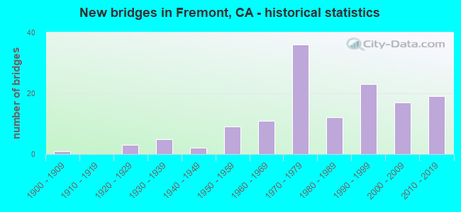
- New bridges - historical statistics
- 11900-1909
- 31920-1929
- 51930-1939
- 21940-1949
- 91950-1959
- 111960-1969
- 361970-1979
- 121980-1989
- 231990-1999
- 172000-2009
- 192010-2019

- Reconstructed bridges - Historical Statistics
- 11960-1969
- 11970-1979
- 31980-1989
- 141990-1999
- 32000-2009
- 52010-2019


- Bridge Condition - Deck
- 34.3%Good
- 20.0%Satisfactory
- 31.4%Fair
- 14.3%Poor

- Bridge Condition - Superstructure
- 75.7%Good
- 1.4%Satisfactory
- 22.9%Fair

- Bridge Condition - Substructure
- 88.6%Good
- 4.3%Satisfactory
- 7.1%Fair

- Bridge Condition - Channel
- 12.9%Excellent
- 29.0%Very good
- 54.8%Good
- 3.2%Satisfactory

- Bridge Condition - Culverts
- 33.3%Good
- 44.4%Satisfactory
- 11.1%Fair
- 11.1%Poor
Find on map >> Show street view
Structure Number: 33 0003, Location: 04-ALA-238-3.46-FMT (Lat: 37.574550, Lng: -121.969506), Route carried "on" structure: State highway 238, Year Built: 1937, Year Reconstructed: 2006, Status: Open, Structure Length: 13.20m (43.31ft), Average Daily Traffic: 98,000 (year 2010), Truck Traffic: 6%, Average Future Daily Traffic: 183,587 (year 2042), Design Load: HS 15, Features Intersected: ALAMEDA CREEK
Minimum Vertical Clearance: 30+ m (98+ ft), Kilometerpoint: 3.460, Lanes on structure: 6, Base Highway Network: Yes (Inventory Route: 2, Subroute: 1), Owner: State Highway Agency, Approaching Roadway Width: 25.9m (85.0ft), Skew: 23 degrees, Material/Design: Concrete continuous, Design/Construction: Tee Beam, Number Of Spans In Main Unit: 11, Length of Maximum Span: 12.2m (40.0ft), Curb or Sidewalk Widths: Left: 1.5m (4.9ft), Right: 1.5m (4.9ft), Curb-To-Curb Width: 25.9m (85.0ft), Out-to-Out Width: 31.5m (103.3ft)
Condition: Deck: Satisfactory, Superstructure: Good, Substructure: Good, Channel: Very good, Operating Rating: 44.7 metric tons, Method Used To Determine Operating Rating: Load Factor (LF), Inventory Rating: 26.9 metric tons, Method Used To Determine Inventory Rating: Load Factor (LF), Structural Evaluation: Equal to present minimum criteria, Deck Geometry: Equal to present minimum criteria, Waterway Adequacy: Better than present minimum criteria, Approach Roadway Alignment: Equal to present desirable criteria, Length Of Structure Improvement: 13.20m (43.31ft), Designated Inspection Frequency: Every 24 months, Inspection Date: Febuary 2022, Deck Structure Type: Concrete Cast-file-Place
Find on map >> Show street view
Structure Number: 33 0036, Location: 04-ALA-084-13.33 (Lat: 37.598819, Lng: -121.939689), Route carried "on" structure: State highway 84, Year Built: 1928, Status: Open, Structure Length: 10.18m (33.40ft), Average Daily Traffic: 14,000 (year 2010), Truck Traffic: 8%, Average Future Daily Traffic: 34,237 (year 2043), Design Load: H 15, Features Intersected: ALAMEDA CREEK
Minimum Vertical Clearance: 30+ m (98+ ft), Kilometerpoint: 13.330, Lanes on structure: 2, Base Highway Network: Yes (, Subroute: 1), Owner: State Highway Agency, Approaching Roadway Width: 7.3m (24.0ft), Skew: 3 degrees, Material/Design: Steel, Design/Construction: Stringer/Multi-beam, Number Of Spans In Main Unit: 2, Number Of Approach Spans: 4, Length of Maximum Span: 24.7m (81.0ft), Curb or Sidewalk Widths: Left: 0.2m (0.7ft), Right: 0.2m (0.7ft), Curb-To-Curb Width: 7.3m (24.0ft), Out-to-Out Width: 8.7m (28.5ft)
Condition: Deck: Fair, Superstructure: Fair, Substructure: Good, Channel: Good, Operating Rating: 27.5 metric tons, Method Used To Determine Operating Rating: Load Factor (LF), Inventory Rating: 16.5 metric tons, Method Used To Determine Inventory Rating: Load Factor (LF), Structural Evaluation: Meets minimum limits, Deck Geometry: High priority of replacement, Waterway Adequacy: Equal to present minimum criteria, Approach Roadway Alignment: Equal to present minimum criteria, Designated Inspection Frequency: Every 24 months, Critical Feature Inspection Frequency: Every 24 months, Inspection Date: August 2021, Critical Feature Inspection Date: April 2021, Deck Structure Type: Concrete Cast-file-Place, Wearing Surface/Protective System: Wearing Surface: Bituminous
Find on map >> Show street view
Structure Number: 33 0051L, Location: 04-ALA-080-R7.20-ALB (Lat: 37.886003, Lng: -122.309033), Route carried "on" structure: Interstate 80, Year Built: 1960, Year Reconstructed: 1998, Status: Open, Structure Length: 65.32m (214.30ft), Average Daily Traffic: 271,000 (year 2009), Truck Traffic: 9%, Average Future Daily Traffic: 433,031 (year 2043), Design Load: HS 20, Features Intersected: UP,BNSF,AMTRAK,E80-W580
Minimum Vertical Clearance: 30+ m (98+ ft), Kilometerpoint: 7.200, Lanes on structure: 4, Lanes under structure: 19, Base Highway Network: Yes (, Subroute: 1), Owner: State Highway Agency, Approaching Roadway Width: 19.7m (64.6ft), Skew: 9 degrees, Material/Design: Steel, Design/Construction: Stringer/Multi-beam, Number Of Spans In Main Unit: 2, Number Of Approach Spans: 29, Length of Maximum Span: 38.3m (125.7ft), Curb-To-Curb Width: 18.5m (60.7ft), Out-to-Out Width: 19.5m (64.0ft)
Condition: Deck: Good, Superstructure: Good, Substructure: Good, Operating Rating: 53.5 metric tons, Method Used To Determine Operating Rating: Load Factor (LF), Inventory Rating: 32.6 metric tons, Method Used To Determine Inventory Rating: Load Factor (LF), Structural Evaluation: Better than present minimum criteria, Deck Geometry: Meets minimum limits, Underclear: High priority of corrective action, Approach Roadway Alignment: Equal to present desirable criteria, Designated Inspection Frequency: Every 24 months, Other Special Inspection Frequency: Every 48 months, Inspection Date: March 2021, Other Special Inspection Date: October 2020, Deck Structure Type: Concrete Cast-file-Place, Wearing Surface/Protective System: Wearing Surface: Integral Concrete
Find on map >> Show street view
Structure Number: 33 0230L, Location: 04-ALA-580-R27.69 (Lat: 37.696000, Lng: -122.044344), Route carried "on" structure: Interstate 580, Year Built: 1986, Status: Open, Structure Length: 10.67m (35.01ft), Average Daily Traffic: 98,500 (year 2017), Average Future Daily Traffic: 111,992 (year 2040), Design Load: HS 20+Mod, Features Intersected: 5 CANYNS RD,SAN LORENZO
Minimum Vertical Clearance: 30+ m (98+ ft), Kilometerpoint: 27.690, Lanes on structure: 4, Lanes under structure: 2, Base Highway Network: Yes (Inventory Route: 5, Subroute: 1), Owner: State Highway Agency, Approaching Roadway Width: 20.1m (65.9ft), Skew: 9 degrees, Material/Design: Prestressed concrete continuous, Design/Construction: Box Beam or Girders - Multiple, Number Of Spans In Main Unit: 3, Length of Maximum Span: 39.6m (129.9ft), Curb-To-Curb Width: 19.9m (65.3ft), Out-to-Out Width: 21.0m (68.9ft)
Condition: Deck: Fair, Superstructure: Good, Substructure: Good, Channel: Very good, Operating Rating: 54.1 metric tons, Method Used To Determine Operating Rating: Assigned rating based on Load Factor Design (LFD) reported in metric tons, Inventory Rating: 32.4 metric tons, Method Used To Determine Inventory Rating: Assigned rating based on Load Factor Design (LFD) reported in metric tons, Structural Evaluation: Better than present minimum criteria, Deck Geometry: Equal to present minimum criteria, Underclear: Superior to present desirable criteria, Waterway Adequacy: Equal to present desirable criteria, Approach Roadway Alignment: Equal to present desirable criteria, Designated Inspection Frequency: Every 24 months, Inspection Date: March 2022, Deck Structure Type: Concrete Cast-file-Place
Find on map >> Show street view
Structure Number: 33 0237, Location: 04-ALA-880-3.25-FMT (Lat: 37.492111, Lng: -121.947506), Route carried "on" structure: City street , Year Built: 1995, Status: Open, Structure Length: 10.07m (33.04ft), Average Daily Traffic: 12,000 (year 2019), Truck Traffic: 9%, Average Future Daily Traffic: 15,000 (year 2042), Design Load: HS 20+Mod, Features Intersected: INTERSTATE 880, Facility Carried by Structure: FREMONT BOULEVARD
Minimum Vertical Clearance: 30+ m (98+ ft), Kilometerpoint: 0.000, Lanes on structure: 7, Lanes under structure: 10, Owner: State Highway Agency, Approaching Roadway Width: 29.9m (98.1ft), Skew: 22 degrees, Material/Design: Prestressed concrete continuous, Design/Construction: Box Beam or Girders - Multiple, Number Of Spans In Main Unit: 2, Length of Maximum Span: 49.2m (161.4ft), Curb or Sidewalk Widths: Left: 0.0m, Right: 1.7m (5.6ft), Curb-To-Curb Width: 29.9m (98.1ft), Out-to-Out Width: 34.2m (112.2ft)
Condition: Deck: Satisfactory, Superstructure: Good, Substructure: Good, Operating Rating: 54.1 metric tons, Method Used To Determine Operating Rating: Assigned rating based on Load Factor Design (LFD) reported in metric tons, Inventory Rating: 32.4 metric tons, Method Used To Determine Inventory Rating: Assigned rating based on Load Factor Design (LFD) reported in metric tons, Structural Evaluation: Better than present minimum criteria, Deck Geometry: Equal to present minimum criteria, Underclear: Equal to present minimum criteria, Approach Roadway Alignment: Equal to present desirable criteria, Designated Inspection Frequency: Every 24 months, Inspection Date: April 2021, Deck Structure Type: Concrete Cast-file-Place
Find on map >> Show street view
Structure Number: 33 0242, Location: 04-ALA-880-R0.26-FMT (Lat: 37.459119, Lng: -121.923842), Route carried "on" structure: Interstate 880, Year Built: 1952, Year Reconstructed: 2003, Status: Open, Structure Length: 1.53m (5.02ft), Average Daily Traffic: 162,000 (year 2019), Truck Traffic: 10%, Average Future Daily Traffic: 229,490 (year 2043), Design Load: HS 20, Features Intersected: SCOTT CREEK
Minimum Vertical Clearance: 30+ m (98+ ft), Kilometerpoint: 0.260, Lanes on structure: 12, Base Highway Network: Yes (Inventory Route: 8, Subroute: 1), Owner: State Highway Agency, Approaching Roadway Width: 65.5m (214.9ft), Skew: 30 degrees, Material/Design: Concrete continuous, Design/Construction: Culvert, Number Of Spans In Main Unit: 4, Length of Maximum Span: 3.7m (12.1ft), Curb-To-Curb Width: 65.5m (214.9ft), Out-to-Out Width: 67.2m (220.5ft)
Condition: Channel: Good, Culverts: Good, Operating Rating: 54.1 metric tons, Method Used To Determine Operating Rating: Field evaluation and documented engineering judgment, Inventory Rating: 32.4 metric tons, Method Used To Determine Inventory Rating: Field evaluation and documented engineering judgment, Structural Evaluation: Better than present minimum criteria, Deck Geometry: Superior to present desirable criteria, Waterway Adequacy: Somewhat better than minimum adequacy, Approach Roadway Alignment: Equal to present desirable criteria, Designated Inspection Frequency: Every 48 months, Inspection Date: April 2021
Find on map >> Show street view
Structure Number: 33 0243, Location: 04-ALA-084-R5.98-FMT (Lat: 37.563064, Lng: -122.038628), Route carried "on" structure: State highway 84, Year Built: 1984, Year Reconstructed: 1990, Status: Open, Structure Length: 9.24m (30.31ft), Average Daily Traffic: 66,000 (year 2010), Truck Traffic: 4%, Average Future Daily Traffic: 100,375 (year 2043), Design Load: HS 20+Mod, Features Intersected: INTERSTATE 880
Minimum Vertical Clearance: 30+ m (98+ ft), Kilometerpoint: 5.980, Lanes on structure: 6, Lanes under structure: 10, Base Highway Network: Yes (, Subroute: 1), Owner: State Highway Agency, Approaching Roadway Width: 30.8m (101.0ft), Skew: 31 degrees, Material/Design: Prestressed concrete continuous, Design/Construction: Box Beam or Girders - Multiple, Number Of Spans In Main Unit: 2, Length of Maximum Span: 46.0m (150.9ft), Curb or Sidewalk Widths: Left: 0.0m, Right: 1.5m (4.9ft), Curb-To-Curb Width: 29.8m (97.8ft), Out-to-Out Width: 32.7m (107.3ft)
Condition: Deck: Good, Superstructure: Good, Substructure: Good, Operating Rating: 54.1 metric tons, Method Used To Determine Operating Rating: Assigned rating based on Load Factor Design (LFD) reported in metric tons, Inventory Rating: 32.4 metric tons, Method Used To Determine Inventory Rating: Assigned rating based on Load Factor Design (LFD) reported in metric tons, Structural Evaluation: Better than present minimum criteria, Deck Geometry: Superior to present desirable criteria, Underclear: Equal to present minimum criteria, Approach Roadway Alignment: Equal to present desirable criteria, Designated Inspection Frequency: Every 24 months, Inspection Date: August 2021, Deck Structure Type: Concrete Cast-file-Place
Find on map >> Show street view
Structure Number: 33 0261L, Location: 04-ALA-880-8.25-FMT (Lat: 37.538989, Lng: -122.017572), Route carried "on" structure: City street , Year Built: 1993, Status: Open, Structure Length: 8.32m (27.30ft), Average Daily Traffic: 82,000 (year 2017), Truck Traffic: 11%, Average Future Daily Traffic: 94,607 (year 2041), Design Load: HS 20+Mod, Features Intersected: INTERSTATE 880, Facility Carried by Structure: CENTRAL AVE SB
Minimum Vertical Clearance: 30+ m (98+ ft), Kilometerpoint: 0.000, Lanes on structure: 2, Lanes under structure: 9, Base Highway Network: Yes, Owner: State Highway Agency, Approaching Roadway Width: 9.5m (31.2ft), Skew: 3 degrees, Material/Design: Prestressed concrete continuous, Design/Construction: Box Beam or Girders - Multiple, Number Of Spans In Main Unit: 2, Length of Maximum Span: 42.4m (139.1ft), Curb or Sidewalk Widths: Left: 1.5m (4.9ft), Right: 0.0m, Curb-To-Curb Width: 9.5m (31.2ft), Out-to-Out Width: 11.8m (38.7ft)
Condition: Deck: Satisfactory, Superstructure: Good, Substructure: Good, Operating Rating: 54.1 metric tons, Method Used To Determine Operating Rating: Assigned rating based on Load Factor Design (LFD) reported in metric tons, Inventory Rating: 32.4 metric tons, Method Used To Determine Inventory Rating: Assigned rating based on Load Factor Design (LFD) reported in metric tons, Structural Evaluation: Better than present minimum criteria, Deck Geometry: Meets minimum limits, Underclear: Meets minimum limits, Approach Roadway Alignment: Equal to present desirable criteria, Designated Inspection Frequency: Every 24 months, Inspection Date: April 2021, Deck Structure Type: Concrete Cast-file-Place
Find on map >> Show street view
Structure Number: 33 0261R, Location: 04-ALA-880-8.24-FMT (Lat: 37.538856, Lng: -122.017469), Route carried "on" structure: City street , Year Built: 1993, Status: Open, Structure Length: 8.32m (27.30ft), Average Daily Traffic: 22,300 (year 2019), Truck Traffic: 11%, Average Future Daily Traffic: 26,279 (year 2042), Design Load: HS 20+Mod, Features Intersected: INTERSTATE 880, Facility Carried by Structure: CENTRAL AVE NB
Minimum Vertical Clearance: 30+ m (98+ ft), Kilometerpoint: 0.000, Lanes on structure: 2, Lanes under structure: 9, Owner: State Highway Agency, Approaching Roadway Width: 9.5m (31.2ft), Skew: 3 degrees, Material/Design: Prestressed concrete continuous, Design/Construction: Box Beam or Girders - Multiple, Number Of Spans In Main Unit: 2, Length of Maximum Span: 42.4m (139.1ft), Curb or Sidewalk Widths: Left: 0.0m, Right: 1.5m (4.9ft), Curb-To-Curb Width: 9.5m (31.2ft), Out-to-Out Width: 11.8m (38.7ft)
Condition: Deck: Satisfactory, Superstructure: Good, Substructure: Good, Operating Rating: 54.1 metric tons, Method Used To Determine Operating Rating: Assigned rating based on Load Factor Design (LFD) reported in metric tons, Inventory Rating: 32.4 metric tons, Method Used To Determine Inventory Rating: Assigned rating based on Load Factor Design (LFD) reported in metric tons, Structural Evaluation: Better than present minimum criteria, Deck Geometry: Meets minimum limits, Underclear: Meets minimum limits, Approach Roadway Alignment: Equal to present desirable criteria, Designated Inspection Frequency: Every 24 months, Inspection Date: April 2021, Deck Structure Type: Concrete Cast-file-Place
Find on map >> Show street view
Structure Number: 33 0264, Location: 04-ALA-084-6.93-FMT (Lat: 37.546175, Lng: -122.023056), Route carried "on" structure: State highway 84, Year Built: 1997, Status: Open, Structure Length: 9.62m (31.56ft), Average Daily Traffic: 66,000 (year 2010), Truck Traffic: 4%, Average Future Daily Traffic: 99,116 (year 2043), Design Load: HS 20+Mod, Features Intersected: INTERSTATE 880
Minimum Vertical Clearance: 30+ m (98+ ft), Kilometerpoint: 6.930, Lanes on structure: 6, Lanes under structure: 10, Base Highway Network: Yes (, Subroute: 1), Owner: State Highway Agency, Approaching Roadway Width: 14.1m (46.3ft), Skew: 22 degrees, Material/Design: Prestressed concrete continuous, Design/Construction: Box Beam or Girders - Multiple, Number Of Spans In Main Unit: 2, Length of Maximum Span: 48.1m (157.8ft), Curb or Sidewalk Widths: Left: 0.0m, Right: 2.4m (7.9ft), Curb-To-Curb Width: 28.2m (92.5ft), Out-to-Out Width: 32.6m (107.0ft)
Condition: Deck: Good, Superstructure: Good, Substructure: Good, Operating Rating: 54.1 metric tons, Method Used To Determine Operating Rating: Assigned rating based on Load Factor Design (LFD) reported in metric tons, Inventory Rating: 32.4 metric tons, Method Used To Determine Inventory Rating: Assigned rating based on Load Factor Design (LFD) reported in metric tons, Structural Evaluation: Better than present minimum criteria, Deck Geometry: Superior to present desirable criteria, Underclear: Meets minimum limits, Approach Roadway Alignment: Equal to present desirable criteria, Designated Inspection Frequency: Every 24 months, Inspection Date: August 2021, Deck Structure Type: Concrete Cast-file-Place
Find on map >> Show street view
Structure Number: 33 0267L, Location: 04-ALA-880-7.19-FMT (Lat: 37.529497, Lng: -122.002531), Route carried "on" structure: City street , Year Built: 1994, Status: Open, Structure Length: 7.94m (26.05ft), Average Daily Traffic: 13,000 (year 2019), Truck Traffic: 5%, Average Future Daily Traffic: 15,508 (year 2042), Design Load: HS 20+Mod, Features Intersected: INTERSTATE 880, Facility Carried by Structure: MOWRY AVENUE WB
Minimum Vertical Clearance: 30+ m (98+ ft), Kilometerpoint: 0.000, Lanes on structure: 4, Lanes under structure: 10, Owner: State Highway Agency, Approaching Roadway Width: 17.6m (57.7ft), Material/Design: Prestressed concrete continuous, Design/Construction: Box Beam or Girders - Multiple, Number Of Spans In Main Unit: 2, Length of Maximum Span: 39.3m (128.9ft), Curb or Sidewalk Widths: Left: 1.8m (5.9ft), Right: 0.0m, Curb-To-Curb Width: 17.7m (58.1ft), Out-to-Out Width: 20.3m (66.6ft)
Condition: Deck: Fair, Superstructure: Good, Substructure: Good, Operating Rating: 54.1 metric tons, Method Used To Determine Operating Rating: Assigned rating based on Load Factor Design (LFD) reported in metric tons, Inventory Rating: 32.4 metric tons, Method Used To Determine Inventory Rating: Assigned rating based on Load Factor Design (LFD) reported in metric tons, Structural Evaluation: Better than present minimum criteria, Deck Geometry: Somewhat better than minimum adequacy, Underclear: Equal to present minimum criteria, Approach Roadway Alignment: Superior to present desirable criteria, Designated Inspection Frequency: Every 24 months, Inspection Date: April 2021, Deck Structure Type: Concrete Cast-file-Place
Find on map >> Show street view
Structure Number: 33 0267R, Location: 04-ALA-880-7.18-FMT (Lat: 37.529389, Lng: -122.002336), Route carried "on" structure: City street , Year Built: 1994, Status: Open, Structure Length: 8.06m (26.44ft), Average Daily Traffic: 13,000 (year 2017), Truck Traffic: 5%, Average Future Daily Traffic: 15,508 (year 2039), Design Load: HS 20+Mod, Features Intersected: INTERSTATE 880, Facility Carried by Structure: MOWRY AVENUE EB
Minimum Vertical Clearance: 30+ m (98+ ft), Kilometerpoint: 0.000, Lanes on structure: 4, Lanes under structure: 10, Owner: State Highway Agency, Approaching Roadway Width: 17.6m (57.7ft), Material/Design: Prestressed concrete continuous, Design/Construction: Box Beam or Girders - Multiple, Number Of Spans In Main Unit: 2, Length of Maximum Span: 40.0m (131.2ft), Curb or Sidewalk Widths: Left: 0.0m, Right: 1.8m (5.9ft), Curb-To-Curb Width: 17.7m (58.1ft), Out-to-Out Width: 20.3m (66.6ft)
Condition: Deck: Fair, Superstructure: Good, Substructure: Good, Operating Rating: 54.1 metric tons, Method Used To Determine Operating Rating: Assigned rating based on Load Factor Design (LFD) reported in metric tons, Inventory Rating: 32.4 metric tons, Method Used To Determine Inventory Rating: Assigned rating based on Load Factor Design (LFD) reported in metric tons, Structural Evaluation: Better than present minimum criteria, Deck Geometry: Somewhat better than minimum adequacy, Underclear: Equal to present minimum criteria, Approach Roadway Alignment: Superior to present desirable criteria, Designated Inspection Frequency: Every 24 months, Inspection Date: April 2021, Deck Structure Type: Concrete Cast-file-Place
Find on map >> Show street view
Structure Number: 33 0268, Location: 04-ALA-880-4.71-FMT (Lat: 37.507081, Lng: -121.967672), Route carried "on" structure: City street , Year Built: 1994, Status: Open, Structure Length: 8.53m (27.99ft), Average Daily Traffic: 11,500 (year 2017), Truck Traffic: 9%, Average Future Daily Traffic: 15,338 (year 2039), Design Load: HS 20+Mod, Features Intersected: INTERSTATE 880, Facility Carried by Structure: AUTO MALL PARKWAY
Minimum Vertical Clearance: 30+ m (98+ ft), Kilometerpoint: 0.000, Lanes on structure: 8, Lanes under structure: 10, Owner: State Highway Agency, Approaching Roadway Width: 36.0m (118.1ft), Skew: 11 degrees, Material/Design: Prestressed concrete continuous, Design/Construction: Box Beam or Girders - Multiple, Number Of Spans In Main Unit: 2, Length of Maximum Span: 43.6m (143.0ft), Curb or Sidewalk Widths: Left: 1.7m (5.6ft), Right: 0.0m, Curb-To-Curb Width: 34.3m (112.5ft), Out-to-Out Width: 37.6m (123.4ft)
Condition: Deck: Good, Superstructure: Good, Substructure: Good, Operating Rating: 54.1 metric tons, Method Used To Determine Operating Rating: Assigned rating based on Load Factor Design (LFD) reported in metric tons, Inventory Rating: 32.4 metric tons, Method Used To Determine Inventory Rating: Assigned rating based on Load Factor Design (LFD) reported in metric tons, Structural Evaluation: Better than present minimum criteria, Deck Geometry: Better than present minimum criteria, Underclear: Equal to present minimum criteria, Approach Roadway Alignment: Superior to present desirable criteria, Designated Inspection Frequency: Every 24 months, Inspection Date: April 2021, Deck Structure Type: Concrete Cast-file-Place
Find on map >> Show street view
Structure Number: 33 0273, Location: 04-ALA-880-10.66-FMT (Lat: 37.567544, Lng: -122.042519), Route carried "on" structure: Interstate 880, Year Built: 1958, Year Reconstructed: 1988, Status: Open, Structure Length: 4.48m (14.70ft), Average Daily Traffic: 225,000 (year 2017), Truck Traffic: 11%, Average Future Daily Traffic: 265,379 (year 2041), Design Load: HS 20, Features Intersected: CRANDALL CREEK
Minimum Vertical Clearance: 30+ m (98+ ft), Kilometerpoint: 10.660, Lanes on structure: 8, Base Highway Network: Yes (Inventory Route: 8, Subroute: 1), Owner: State Highway Agency, Approaching Roadway Width: 44.0m (144.4ft), Skew: 33 degrees, Material/Design: Concrete continuous, Design/Construction: Slab, Number Of Spans In Main Unit: 6, Length of Maximum Span: 7.3m (24.0ft), Curb-To-Curb Width: 44.0m (144.4ft), Out-to-Out Width: 45.8m (150.3ft)
Condition: Deck: Fair, Superstructure: Fair, Substructure: Good, Channel: Very good, Operating Rating: 35.6 metric tons, Method Used To Determine Operating Rating: Load and Resistance Factor Rating (LRFR) rating reported by rating factor(RF) method using HL-93 loadings, Inventory Rating: 27.5 metric tons, Method Used To Determine Inventory Rating: Load and Resistance Factor Rating (LRFR) rating reported by rating factor(RF) method using HL-93 loadings, Structural Evaluation: Somewhat better than minimum adequacy, Deck Geometry: Superior to present desirable criteria, Waterway Adequacy: Equal to present desirable criteria, Approach Roadway Alignment: Equal to present desirable criteria, Length Of Structure Improvement: 4.48m (14.70ft), Designated Inspection Frequency: Every 24 months, Inspection Date: April 2021, Deck Structure Type: Concrete Cast-file-Place
Find on map >> Show street view
Structure Number: 33 0291, Location: 04-ALA-880-3.67-FMT (Lat: 37.496997, Lng: -121.953800), Route carried "on" structure: Interstate 880, Year Built: 1958, Status: Open, Structure Length: 1.22m (4.00ft), Average Daily Traffic: 161,000 (year 2019), Truck Traffic: 5%, Average Future Daily Traffic: 200,814 (year 2042), Features Intersected: ARROYO DE LA LAGUNA CRK
Minimum Vertical Clearance: 30+ m (98+ ft), Kilometerpoint: 3.670, Lanes on structure: 10, Base Highway Network: Yes (Inventory Route: 8, Subroute: 1), Owner: State Highway Agency, Approaching Roadway Width: 33.5m (109.9ft), Skew: 32 degrees, Material/Design: Concrete continuous, Design/Construction: Culvert, Number Of Spans In Main Unit: 3, Length of Maximum Span: 3.7m (12.1ft)
Condition: Channel: Good, Culverts: Satisfactory, Operating Rating: 54.1 metric tons, Method Used To Determine Operating Rating: Field evaluation and documented engineering judgment, Inventory Rating: 32.4 metric tons, Method Used To Determine Inventory Rating: Field evaluation and documented engineering judgment, Structural Evaluation: Equal to present minimum criteria, Waterway Adequacy: Better than present minimum criteria, Approach Roadway Alignment: Equal to present desirable criteria, Designated Inspection Frequency: Every 48 months, Inspection Date: April 2021
Find on map >> Show street view
Structure Number: 33 0292, Location: 04-ALA-880-2.77-FMT (Lat: 37.487792, Lng: -121.941822), Route carried "on" structure: Interstate 880, Year Built: 1958, Year Reconstructed: 2006, Status: Open, Structure Length: 0.70m (2.30ft), Average Daily Traffic: 161,000 (year 2019), Truck Traffic: 5%, Average Future Daily Traffic: 200,814 (year 2042), Features Intersected: AGUA CALIENTE CREEK
Minimum Vertical Clearance: 30+ m (98+ ft), Kilometerpoint: 2.770, Lanes on structure: 11, Base Highway Network: Yes (Inventory Route: 8, Subroute: 1), Owner: State Highway Agency, Approaching Roadway Width: 26.5m (86.9ft), Skew: 1 degrees, Material/Design: Concrete continuous, Design/Construction: Culvert, Number Of Spans In Main Unit: 2, Length of Maximum Span: 3.0m (9.8ft)
Condition: Channel: Good, Culverts: Satisfactory, Operating Rating: 54.1 metric tons, Method Used To Determine Operating Rating: Field evaluation and documented engineering judgment, Inventory Rating: 32.4 metric tons, Method Used To Determine Inventory Rating: Field evaluation and documented engineering judgment, Structural Evaluation: Equal to present minimum criteria, Waterway Adequacy: Better than present minimum criteria, Approach Roadway Alignment: Equal to present desirable criteria, Designated Inspection Frequency: Every 48 months, Inspection Date: April 2021
Find on map >> Show street view
Structure Number: 33 0294, Location: 04-ALA-680-R6.38-FMT (Lat: 37.540306, Lng: -121.924547), Route carried "on" structure: Interstate 680, Year Built: 1963, Year Reconstructed: 2010, Status: Open, Structure Length: 5.43m (17.81ft), Average Daily Traffic: 140,000 (year 2018), Truck Traffic: 9%, Average Future Daily Traffic: 241,101 (year 2042), Design Load: HS 20, Features Intersected: SR 238 (MISSION BLVD)
Minimum Vertical Clearance: 30+ m (98+ ft), Kilometerpoint: 6.380, Lanes on structure: 8, Lanes under structure: 5, Base Highway Network: Yes (Inventory Route: 6, Subroute: 1), Owner: State Highway Agency, Approaching Roadway Width: 43.1m (141.4ft), Skew: 31 degrees, Material/Design: Concrete continuous, Design/Construction: Box Beam or Girders - Multiple, Number Of Spans In Main Unit: 3, Length of Maximum Span: 27.7m (90.9ft), Curb-To-Curb Width: 43.1m (141.4ft), Out-to-Out Width: 45.3m (148.6ft)
Condition: Deck: Fair, Superstructure: Good, Substructure: Fair, Operating Rating: 48.0 metric tons, Method Used To Determine Operating Rating: Load and Resistance Factor Rating (LRFR) rating reported by rating factor(RF) method using HL-93 loadings, Inventory Rating: 36.9 metric tons, Method Used To Determine Inventory Rating: Load and Resistance Factor Rating (LRFR) rating reported by rating factor(RF) method using HL-93 loadings, Structural Evaluation: Somewhat better than minimum adequacy, Deck Geometry: Superior to present desirable criteria, Underclear: Equal to present minimum criteria, Approach Roadway Alignment: Superior to present desirable criteria, Designated Inspection Frequency: Every 24 months, Inspection Date: March 2020, Deck Structure Type: Concrete Cast-file-Place
Find on map >> Show street view
Structure Number: 33 0306, Location: 04-ALA-680-R7.48-FMT (Lat: 37.554278, Lng: -121.916386), Route carried "on" structure: Interstate 680, Year Built: 1963, Year Reconstructed: 2010, Status: Open, Structure Length: 4.53m (14.86ft), Average Daily Traffic: 142,000 (year 2018), Truck Traffic: 9%, Average Future Daily Traffic: 181,080 (year 2042), Design Load: HS 20+Mod, Features Intersected: VARGAS ROAD
Minimum Vertical Clearance: 30+ m (98+ ft), Kilometerpoint: 7.480, Lanes on structure: 8, Lanes under structure: 2, Base Highway Network: Yes (Inventory Route: 6, Subroute: 1), Owner: State Highway Agency, Approaching Roadway Width: 44.9m (147.3ft), Skew: 39 degrees, Material/Design: Concrete continuous, Design/Construction: Box Beam or Girders - Multiple, Number Of Spans In Main Unit: 3, Length of Maximum Span: 17.8m (58.4ft), Curb-To-Curb Width: 44.9m (147.3ft), Out-to-Out Width: 46.6m (152.9ft)
Condition: Deck: Good, Superstructure: Good, Substructure: Good, Operating Rating: 54.1 metric tons, Method Used To Determine Operating Rating: Assigned rating based on Load Factor Design (LFD) reported in metric tons, Inventory Rating: 32.4 metric tons, Method Used To Determine Inventory Rating: Assigned rating based on Load Factor Design (LFD) reported in metric tons, Structural Evaluation: Better than present minimum criteria, Deck Geometry: Superior to present desirable criteria, Underclear: Superior to present desirable criteria, Approach Roadway Alignment: Equal to present desirable criteria, Designated Inspection Frequency: Every 24 months, Inspection Date: March 2020, Deck Structure Type: Concrete Cast-file-Place, Wearing Surface/Protective System: Wearing Surface: Integral Concrete
Find on map >> Show street view
Structure Number: 33 0306K, Location: 04-ALA-680-R7.46-FMT (Lat: 37.554886, Lng: -121.916614), Route carried "on" structure: Ramp Interstate 680, Year Built: 2010, Status: Open, Structure Length: 4.19m (13.75ft), Average Daily Traffic: 8,000 (year 2018), Truck Traffic: 6%, Average Future Daily Traffic: 12,242 (year 2042), Design Load: HS 20+Mod, Features Intersected: VARGAS ROAD, Facility Carried by Structure: SB OFFRAMP VARGAS
Minimum Vertical Clearance: 30+ m (98+ ft), Kilometerpoint: 7.460, Lanes on structure: 1, Lanes under structure: 2, Base Highway Network: Yes (Inventory Route: 6, Subroute: 1), Owner: State Highway Agency, Approaching Roadway Width: 6.7m (22.0ft), Material/Design: Prestressed concrete, Design/Construction: Box Beam or Girders - Single/Spread, Number Of Spans In Main Unit: 1, Length of Maximum Span: 41.9m (137.5ft), Curb-To-Curb Width: 6.7m (22.0ft), Out-to-Out Width: 7.5m (24.6ft)
Condition: Deck: Fair, Superstructure: Good, Substructure: Good, Operating Rating: 54.1 metric tons, Method Used To Determine Operating Rating: Assigned rating based on Load Factor Design (LFD) reported in metric tons, Inventory Rating: 32.4 metric tons, Method Used To Determine Inventory Rating: Assigned rating based on Load Factor Design (LFD) reported in metric tons, Structural Evaluation: Better than present minimum criteria, Deck Geometry: Equal to present minimum criteria, Underclear: Meets minimum limits, Approach Roadway Alignment: Equal to present desirable criteria, Designated Inspection Frequency: Every 24 months, Inspection Date: March 2020, Deck Structure Type: Concrete Cast-file-Place
Find on map >> Show street view
Structure Number: 33 036, Location: 04-ALA-680-M5.91-FMT (Lat: 37.535569, Lng: -121.933572), Route carried "on" structure: County highway , Year Built: 1971, Status: Open, Structure Length: 6.80m (22.31ft), Average Daily Traffic: 3,388 (year 2018), Truck Traffic: 2%, Average Future Daily Traffic: 5,362 (year 2042), Design Load: HS 20+Mod, Features Intersected: INTERSTATE 680, Facility Carried by Structure: PALM AVE
Minimum Vertical Clearance: 30+ m (98+ ft), Kilometerpoint: 0.000, Lanes on structure: 2, Lanes under structure: 7, Owner: State Highway Agency, Approaching Roadway Width: 9.8m (32.2ft), Skew: 2 degrees, Material/Design: Prestressed concrete continuous, Design/Construction: Box Beam or Girders - Multiple, Number Of Spans In Main Unit: 2, Length of Maximum Span: 36.0m (118.1ft), Curb or Sidewalk Widths: Left: 1.5m (4.9ft), Right: 1.5m (4.9ft), Curb-To-Curb Width: 12.2m (40.0ft), Out-to-Out Width: 15.8m (51.8ft)
Condition: Deck: Good, Superstructure: Fair, Substructure: Good, Operating Rating: 64.8 metric tons, Method Used To Determine Operating Rating: Load and Resistance Factor Rating (LRFR) rating reported by rating factor(RF) method using HL-93 loadings, Inventory Rating: 43.7 metric tons, Method Used To Determine Inventory Rating: Load and Resistance Factor Rating (LRFR) rating reported by rating factor(RF) method using HL-93 loadings, Structural Evaluation: Somewhat better than minimum adequacy, Deck Geometry: Equal to present minimum criteria, Underclear: Meets minimum limits, Approach Roadway Alignment: Equal to present desirable criteria, Designated Inspection Frequency: Every 24 months, Inspection Date: March 2020, Deck Structure Type: Concrete Cast-file-Place
Find on map >> Show street view
Structure Number: 33 0361, Location: 04-ALA-680-M5.37-FMT (Lat: 37.531064, Lng: -121.942278), Route carried "on" structure: County highway , Year Built: 1971, Status: Open, Structure Length: 9.75m (31.99ft), Average Daily Traffic: 17,017 (year 2018), Truck Traffic: 2%, Average Future Daily Traffic: 21,448 (year 2042), Design Load: HS 20+Mod, Features Intersected: INTERSTATE 680, Facility Carried by Structure: WASHINGTON BLVD
Minimum Vertical Clearance: 30+ m (98+ ft), Kilometerpoint: 0.000, Lanes on structure: 4, Lanes under structure: 8, Owner: State Highway Agency, Approaching Roadway Width: 15.8m (51.8ft), Skew: 24 degrees, Material/Design: Prestressed concrete continuous, Design/Construction: Box Beam or Girders - Multiple, Number Of Spans In Main Unit: 2, Length of Maximum Span: 52.3m (171.6ft), Curb or Sidewalk Widths: Left: 1.5m (4.9ft), Right: 1.5m (4.9ft), Curb-To-Curb Width: 15.8m (51.8ft), Out-to-Out Width: 25.0m (82.0ft)
Condition: Deck: Poor, Superstructure: Fair, Substructure: Good, Operating Rating: 62.5 metric tons, Method Used To Determine Operating Rating: Load and Resistance Factor Rating (LRFR) rating reported by rating factor(RF) method using HL-93 loadings, Inventory Rating: 44.4 metric tons, Method Used To Determine Inventory Rating: Load and Resistance Factor Rating (LRFR) rating reported by rating factor(RF) method using HL-93 loadings, Structural Evaluation: Somewhat better than minimum adequacy, Deck Geometry: Meets minimum limits, Underclear: Superior to present desirable criteria, Approach Roadway Alignment: Equal to present desirable criteria, Length Of Structure Improvement: 9.75m (31.99ft), Designated Inspection Frequency: Every 24 months, Inspection Date: March 2020, Bridge Improvement Cost: $1,540,000, Roadway Improvement Cost: $308,000, Total Project Cost: $2,587,000 ( Estimate for 2021), Deck Structure Type: Concrete Cast-file-Place
Find on map >> Show street view
Structure Number: 33 0368, Location: 04-ALA-680-M4.02-FMT (Lat: 37.514406, Lng: -121.940133), Route carried "on" structure: City street , Year Built: 1971, Status: Open, Structure Length: 8.11m (26.61ft), Average Daily Traffic: 21,534 (year 2018), Truck Traffic: 2%, Average Future Daily Traffic: 26,810 (year 2042), Design Load: HS 20+Mod, Features Intersected: INTERSTATE 680, Facility Carried by Structure: AUTO MALL PARKWAY
Minimum Vertical Clearance: 30+ m (98+ ft), Kilometerpoint: 0.000, Lanes on structure: 4, Lanes under structure: 10, Owner: State Highway Agency, Approaching Roadway Width: 29.0m (95.1ft), Skew: 20 degrees, Material/Design: Prestressed concrete continuous, Design/Construction: Box Beam or Girders - Multiple, Number Of Spans In Main Unit: 2, Length of Maximum Span: 43.9m (144.0ft), Curb or Sidewalk Widths: Left: 1.5m (4.9ft), Right: 1.5m (4.9ft), Curb-To-Curb Width: 20.6m (67.6ft), Out-to-Out Width: 28.7m (94.2ft)
Condition: Deck: Poor, Superstructure: Good, Substructure: Good, Operating Rating: 50.9 metric tons, Method Used To Determine Operating Rating: Load and Resistance Factor Rating (LRFR) rating reported by rating factor(RF) method using HL-93 loadings, Inventory Rating: 36.3 metric tons, Method Used To Determine Inventory Rating: Load and Resistance Factor Rating (LRFR) rating reported by rating factor(RF) method using HL-93 loadings, Structural Evaluation: Better than present minimum criteria, Deck Geometry: Superior to present desirable criteria, Underclear: Meets minimum limits, Approach Roadway Alignment: Equal to present desirable criteria, Designated Inspection Frequency: Every 24 months, Inspection Date: March 2020, Deck Structure Type: Concrete Cast-file-Place
Find on map >> Show street view
Structure Number: 33 0405, Location: 04-ALA-680-M5.67-FMT (Lat: 37.533592, Lng: -121.937431), Route carried "on" structure: City street , Year Built: 1971, Status: Open, Structure Length: 6.80m (22.31ft), Average Daily Traffic: 9,505 (year 2018), Truck Traffic: 2%, Average Future Daily Traffic: 10,724 (year 2042), Design Load: HS 20+Mod, Features Intersected: INTERSTATE 680, Facility Carried by Structure: PASEO PADRE PKWY
Minimum Vertical Clearance: 30+ m (98+ ft), Kilometerpoint: 0.000, Lanes on structure: 4, Lanes under structure: 8, Owner: State Highway Agency, Approaching Roadway Width: 25.0m (82.0ft), Skew: 22 degrees, Material/Design: Concrete continuous, Design/Construction: Box Beam or Girders - Multiple, Number Of Spans In Main Unit: 2, Length of Maximum Span: 37.8m (124.0ft), Curb or Sidewalk Widths: Left: 1.5m (4.9ft), Right: 1.5m (4.9ft), Curb-To-Curb Width: 19.6m (64.3ft), Out-to-Out Width: 28.7m (94.2ft)
Condition: Deck: Satisfactory, Superstructure: Fair, Substructure: Good, Operating Rating: 47.0 metric tons, Method Used To Determine Operating Rating: Load and Resistance Factor Rating (LRFR) rating reported by rating factor(RF) method using HL-93 loadings, Inventory Rating: 33.7 metric tons, Method Used To Determine Inventory Rating: Load and Resistance Factor Rating (LRFR) rating reported by rating factor(RF) method using HL-93 loadings, Structural Evaluation: Somewhat better than minimum adequacy, Deck Geometry: Better than present minimum criteria, Underclear: Equal to present desirable criteria, Approach Roadway Alignment: Equal to present desirable criteria, Designated Inspection Frequency: Every 24 months, Inspection Date: March 2020, Deck Structure Type: Concrete Cast-file-Place
Find on map >> Show street view
Structure Number: 33 0420L, Location: 04-ALA-024-R4.44-OAK (Lat: 37.849983, Lng: -122.240078), Route carried "on" structure: State highway 24, Year Built: 1970, Status: Open, Structure Length: 4.11m (13.48ft), Average Daily Traffic: 143,000 (year 2010), Truck Traffic: 2%, Average Future Daily Traffic: 269,675 (year 2044), Design Load: HS 20, Features Intersected: GOLDEN GATE AVE
Minimum Vertical Clearance: 30+ m (98+ ft), Kilometerpoint: 4.440, Lanes on structure: 5, Lanes under structure: 2, Base Highway Network: Yes (, Subroute: 1), Owner: State Highway Agency, Approaching Roadway Width: 23.2m (76.1ft), Skew: 29 degrees, Material/Design: Prestressed concrete, Design/Construction: Box Beam or Girders - Multiple, Number Of Spans In Main Unit: 1, Number Of Approach Spans: 2, Length of Maximum Span: 39.6m (129.9ft), Curb-To-Curb Width: 23.2m (76.1ft), Out-to-Out Width: 23.7m (77.8ft)
Condition: Deck: Good, Superstructure: Good, Substructure: Good, Operating Rating: 90.1 metric tons, Method Used To Determine Operating Rating: Load Factor (LF), Inventory Rating: 32.4 metric tons, Method Used To Determine Inventory Rating: Load Factor (LF), Structural Evaluation: Better than present minimum criteria, Deck Geometry: Somewhat better than minimum adequacy, Underclear: Meets minimum limits, Approach Roadway Alignment: Equal to present desirable criteria, Designated Inspection Frequency: Every 24 months, Inspection Date: Febuary 2022, Deck Structure Type: Concrete Cast-file-Place
Find on map >> Show street view
Structure Number: 33 0423L, Location: 04-ALA-680-M0.06-FMT (Lat: 37.465325, Lng: -121.904808), Route carried "on" structure: Interstate 680, Year Built: 1971, Year Reconstructed: 1997, Status: Open, Structure Length: 7.68m (25.20ft), Average Daily Traffic: 61,000 (year 2018), Average Future Daily Traffic: 110,187 (year 2042), Design Load: HS 20+Mod, Features Intersected: STATE ROUTE 237 (FUTURE)
Minimum Vertical Clearance: 30+ m (98+ ft), Kilometerpoint: 0.060, Lanes on structure: 4, Base Highway Network: Yes (Inventory Route: 6, Subroute: 1), Owner: State Highway Agency, Approaching Roadway Width: 21.2m (69.6ft), Skew: 15 degrees, Material/Design: Concrete continuous, Design/Construction: Box Beam or Girders - Multiple, Number Of Spans In Main Unit: 3, Length of Maximum Span: 32.6m (107.0ft), Curb-To-Curb Width: 21.2m (69.6ft), Out-to-Out Width: 21.8m (71.5ft)
Condition: Deck: Poor, Superstructure: Good, Substructure: Good, Operating Rating: 54.1 metric tons, Method Used To Determine Operating Rating: Assigned rating based on Load Factor Design (LFD) reported in metric tons, Inventory Rating: 32.4 metric tons, Method Used To Determine Inventory Rating: Assigned rating based on Load Factor Design (LFD) reported in metric tons, Structural Evaluation: Better than present minimum criteria, Deck Geometry: Better than present minimum criteria, Approach Roadway Alignment: Equal to present desirable criteria, Designated Inspection Frequency: Every 24 months, Inspection Date: March 2020, Deck Structure Type: Concrete Cast-file-Place
Find on map >> Show street view
Structure Number: 33 0423R, Location: 04-ALA-680-M0.04-FMT (Lat: 37.465067, Lng: -121.904256), Route carried "on" structure: Interstate 680, Year Built: 1971, Year Reconstructed: 1997, Status: Open, Structure Length: 8.17m (26.80ft), Average Daily Traffic: 61,000 (year 2018), Average Future Daily Traffic: 110,187 (year 2042), Design Load: HS 20+Mod, Features Intersected: STATE ROUTE 237 (FUTURE)
Minimum Vertical Clearance: 30+ m (98+ ft), Kilometerpoint: 0.040, Lanes on structure: 3, Base Highway Network: Yes (Inventory Route: 6, Subroute: 1), Owner: State Highway Agency, Approaching Roadway Width: 21.2m (69.6ft), Skew: 6 degrees, Material/Design: Concrete continuous, Design/Construction: Box Beam or Girders - Multiple, Number Of Spans In Main Unit: 3, Length of Maximum Span: 35.1m (115.2ft), Curb-To-Curb Width: 21.2m (69.6ft), Out-to-Out Width: 21.8m (71.5ft)
Condition: Deck: Poor, Superstructure: Good, Substructure: Fair, Operating Rating: 53.8 metric tons, Method Used To Determine Operating Rating: Load Factor (LF), Inventory Rating: 32.4 metric tons, Method Used To Determine Inventory Rating: Load Factor (LF), Structural Evaluation: Somewhat better than minimum adequacy, Deck Geometry: Superior to present desirable criteria, Approach Roadway Alignment: Equal to present desirable criteria, Length Of Structure Improvement: 8.17m (26.80ft), Designated Inspection Frequency: Every 24 months, Inspection Date: March 2020, Bridge Improvement Cost: $1,780,000, Roadway Improvement Cost: $356,000, Total Project Cost: $2,990,000 ( Estimate for 2021), Deck Structure Type: Concrete Cast-file-Place
Find on map >> Show street view
Structure Number: 33 0424L, Location: 04-ALA-680-M0.13-FMT (Lat: 37.466311, Lng: -121.905147), Route carried "on" structure: Interstate 680, Year Built: 1971, Year Reconstructed: 1997, Status: Open, Structure Length: 4.93m (16.17ft), Average Daily Traffic: 61,000 (year 2018), Truck Traffic: 7%, Average Future Daily Traffic: 107,650 (year 2042), Design Load: HS 20+Mod, Features Intersected: SCOTT CREEK RD
Minimum Vertical Clearance: 30+ m (98+ ft), Kilometerpoint: 0.130, Lanes on structure: 4, Lanes under structure: 3, Base Highway Network: Yes (Inventory Route: 6, Subroute: 1), Owner: State Highway Agency, Approaching Roadway Width: 21.2m (69.6ft), Skew: 2 degrees, Material/Design: Concrete continuous, Design/Construction: Box Beam or Girders - Multiple, Number Of Spans In Main Unit: 2, Length of Maximum Span: 26.6m (87.3ft), Curb-To-Curb Width: 21.2m (69.6ft), Out-to-Out Width: 21.8m (71.5ft)
Condition: Deck: Satisfactory, Superstructure: Good, Substructure: Good, Operating Rating: 54.1 metric tons, Method Used To Determine Operating Rating: Assigned rating based on Load Factor Design (LFD) reported in metric tons, Inventory Rating: 32.4 metric tons, Method Used To Determine Inventory Rating: Assigned rating based on Load Factor Design (LFD) reported in metric tons, Structural Evaluation: Better than present minimum criteria, Deck Geometry: Better than present minimum criteria, Underclear: Equal to present minimum criteria, Approach Roadway Alignment: Equal to present desirable criteria, Designated Inspection Frequency: Every 48 months, Inspection Date: March 2020, Deck Structure Type: Concrete Cast-file-Place
Find on map >> Show street view
Structure Number: 33 0424R, Location: 04-ALA-680-M0.13-FMT (Lat: 37.466247, Lng: -121.905572), Route carried "on" structure: Interstate 680, Year Built: 1971, Year Reconstructed: 1997, Status: Open, Structure Length: 5.11m (16.77ft), Average Daily Traffic: 61,000 (year 2018), Truck Traffic: 7%, Average Future Daily Traffic: 107,650 (year 2042), Design Load: HS 20+Mod, Features Intersected: SCOTT CREEK RD
Minimum Vertical Clearance: 30+ m (98+ ft), Kilometerpoint: 0.130, Lanes on structure: 4, Lanes under structure: 2, Base Highway Network: Yes (Inventory Route: 6, Subroute: 1), Owner: State Highway Agency, Approaching Roadway Width: 21.6m (70.9ft), Skew: 22 degrees, Material/Design: Concrete continuous, Design/Construction: Box Beam or Girders - Multiple, Number Of Spans In Main Unit: 2, Length of Maximum Span: 27.5m (90.2ft), Curb-To-Curb Width: 28.2m (92.5ft), Out-to-Out Width: 31.5m (103.3ft)
Condition: Deck: Satisfactory, Superstructure: Fair, Substructure: Good, Operating Rating: 54.1 metric tons, Method Used To Determine Operating Rating: Assigned rating based on Load Factor Design (LFD) reported in metric tons, Inventory Rating: 32.4 metric tons, Method Used To Determine Inventory Rating: Assigned rating based on Load Factor Design (LFD) reported in metric tons, Structural Evaluation: Somewhat better than minimum adequacy, Deck Geometry: Superior to present desirable criteria, Underclear: Equal to present minimum criteria, Approach Roadway Alignment: Equal to present desirable criteria, Length Of Structure Improvement: 5.09m (16.70ft), Designated Inspection Frequency: Every 24 months, Inspection Date: March 2020, Deck Structure Type: Concrete Cast-file-Place
Find on map >> Show street view
Structure Number: 33 0427L, Location: 04-ALA-680-M1.96-FMT (Lat: 37.490486, Lng: -121.918492), Route carried "on" structure: Interstate 680, Year Built: 1971, Year Reconstructed: 2010, Status: Open, Structure Length: 6.67m (21.88ft), Average Daily Traffic: 61,000 (year 2018), Truck Traffic: 8%, Average Future Daily Traffic: 110,187 (year 2042), Design Load: HS 20+Mod, Features Intersected: E WARREN AVE
Minimum Vertical Clearance: 30+ m (98+ ft), Kilometerpoint: 1.960, Lanes on structure: 5, Lanes under structure: 4, Base Highway Network: Yes (Inventory Route: 6, Subroute: 1), Owner: State Highway Agency, Approaching Roadway Width: 24.8m (81.4ft), Skew: 2 degrees, Material/Design: Prestressed concrete continuous, Design/Construction: Box Beam or Girders - Multiple, Number Of Spans In Main Unit: 2, Length of Maximum Span: 34.7m (113.8ft), Curb-To-Curb Width: 24.8m (81.4ft), Out-to-Out Width: 25.5m (83.7ft)
Condition: Deck: Poor, Superstructure: Good, Substructure: Good, Operating Rating: 54.1 metric tons, Method Used To Determine Operating Rating: Assigned rating based on Load Factor Design (LFD) reported in metric tons, Inventory Rating: 32.4 metric tons, Method Used To Determine Inventory Rating: Assigned rating based on Load Factor Design (LFD) reported in metric tons, Structural Evaluation: Better than present minimum criteria, Deck Geometry: Better than present minimum criteria, Underclear: Somewhat better than minimum adequacy, Approach Roadway Alignment: Equal to present desirable criteria, Designated Inspection Frequency: Every 24 months, Inspection Date: March 2020, Deck Structure Type: Concrete Cast-file-Place
Find on map >> Show street view
Structure Number: 33 0427R, Location: 04-ALA-680-M1.97-FMT (Lat: 37.490836, Lng: -121.918289), Route carried "on" structure: Interstate 680, Year Built: 1971, Year Reconstructed: 1997, Status: Open, Structure Length: 7.77m (25.49ft), Average Daily Traffic: 61,000 (year 2018), Truck Traffic: 8%, Average Future Daily Traffic: 110,187 (year 2042), Design Load: HS 20+Mod, Features Intersected: E WARREN AVE
Minimum Vertical Clearance: 30+ m (98+ ft), Kilometerpoint: 1.970, Lanes on structure: 4, Lanes under structure: 4, Base Highway Network: Yes (Inventory Route: 6, Subroute: 1), Owner: State Highway Agency, Approaching Roadway Width: 24.2m (79.4ft), Skew: 4 degrees, Material/Design: Prestressed concrete continuous, Design/Construction: Box Beam or Girders - Multiple, Number Of Spans In Main Unit: 2, Length of Maximum Span: 41.8m (137.1ft), Curb-To-Curb Width: 24.2m (79.4ft), Out-to-Out Width: 24.8m (81.4ft)
Condition: Deck: Poor, Superstructure: Good, Substructure: Good, Operating Rating: 54.1 metric tons, Method Used To Determine Operating Rating: Assigned rating based on Load Factor Design (LFD) reported in metric tons, Inventory Rating: 32.4 metric tons, Method Used To Determine Inventory Rating: Assigned rating based on Load Factor Design (LFD) reported in metric tons, Structural Evaluation: Better than present minimum criteria, Deck Geometry: Superior to present desirable criteria, Underclear: Somewhat better than minimum adequacy, Approach Roadway Alignment: Equal to present desirable criteria, Designated Inspection Frequency: Every 24 months, Inspection Date: March 2020, Deck Structure Type: Concrete Cast-file-Place
Find on map >> Show street view
Structure Number: 33 0428L, Location: 04-ALA-680-M2.38-FMT (Lat: 37.495575, Lng: -121.922700), Route carried "on" structure: Interstate 680, Year Built: 1971, Year Reconstructed: 1997, Status: Open, Structure Length: 5.36m (17.59ft), Average Daily Traffic: 61,000 (year 2018), Truck Traffic: 7%, Average Future Daily Traffic: 110,923 (year 2042), Design Load: HS 20+Mod, Features Intersected: SR 262 (MISSION BLVD)
Minimum Vertical Clearance: 30+ m (98+ ft), Kilometerpoint: 2.380, Lanes on structure: 6, Lanes under structure: 6, Base Highway Network: Yes (Inventory Route: 6, Subroute: 1), Owner: State Highway Agency, Approaching Roadway Width: 29.0m (95.1ft), Material/Design: Concrete continuous, Design/Construction: Box Beam or Girders - Multiple, Number Of Spans In Main Unit: 2, Length of Maximum Span: 26.5m (86.9ft), Curb-To-Curb Width: 31.4m (103.0ft), Out-to-Out Width: 35.2m (115.5ft)
Condition: Deck: Poor, Superstructure: Good, Substructure: Good, Operating Rating: 54.1 metric tons, Method Used To Determine Operating Rating: Assigned rating based on Load Factor Design (LFD) reported in metric tons, Inventory Rating: 32.4 metric tons, Method Used To Determine Inventory Rating: Assigned rating based on Load Factor Design (LFD) reported in metric tons, Structural Evaluation: Better than present minimum criteria, Deck Geometry: Superior to present desirable criteria, Underclear: Meets minimum limits, Approach Roadway Alignment: Equal to present desirable criteria, Length Of Structure Improvement: 5.36m (17.59ft), Designated Inspection Frequency: Every 24 months, Inspection Date: March 2020, Bridge Improvement Cost: $1,683,000, Roadway Improvement Cost: $336,000, Total Project Cost: $2,827,000 ( Estimate for 2021), Deck Structure Type: Concrete Cast-file-Place
Find on map >> Show street view
Structure Number: 33 0428R, Location: 04-ALA-680-M2.38-FMT (Lat: 37.495353, Lng: -121.923028), Route carried "on" structure: Interstate 680, Year Built: 1971, Year Reconstructed: 1997, Status: Open, Structure Length: 5.36m (17.59ft), Average Daily Traffic: 61,000 (year 2018), Truck Traffic: 7%, Average Future Daily Traffic: 110,923 (year 2042), Design Load: HS 20, Features Intersected: SR 262 (MISSION BLVD)
Minimum Vertical Clearance: 30+ m (98+ ft), Kilometerpoint: 2.380, Lanes on structure: 5, Lanes under structure: 6, Base Highway Network: Yes (Inventory Route: 6, Subroute: 1), Owner: State Highway Agency, Approaching Roadway Width: 29.0m (95.1ft), Material/Design: Concrete continuous, Design/Construction: Box Beam or Girders - Multiple, Number Of Spans In Main Unit: 2, Length of Maximum Span: 26.5m (86.9ft), Curb-To-Curb Width: 31.4m (103.0ft), Out-to-Out Width: 35.2m (115.5ft)
Condition: Deck: Poor, Superstructure: Good, Substructure: Good, Operating Rating: 54.1 metric tons, Method Used To Determine Operating Rating: Assigned rating based on Load Factor Design (LFD) reported in metric tons, Inventory Rating: 32.4 metric tons, Method Used To Determine Inventory Rating: Assigned rating based on Load Factor Design (LFD) reported in metric tons, Structural Evaluation: Better than present minimum criteria, Deck Geometry: Superior to present desirable criteria, Underclear: Meets minimum limits, Approach Roadway Alignment: Equal to present desirable criteria, Length Of Structure Improvement: 5.36m (17.59ft), Designated Inspection Frequency: Every 24 months, Inspection Date: March 2020, Bridge Improvement Cost: $1,683,000, Roadway Improvement Cost: $336,000, Total Project Cost: $2,827,000 ( Estimate for 2021), Deck Structure Type: Concrete Cast-file-Place
Find on map >> Show street view
Structure Number: 33 0429L, Location: 04-ALA-680-M3.35-FMT (Lat: 37.506000, Lng: -121.934325), Route carried "on" structure: Interstate 680, Year Built: 1971, Year Reconstructed: 2001, Status: Open, Structure Length: 4.48m (14.70ft), Average Daily Traffic: 70,000 (year 2018), Truck Traffic: 9%, Average Future Daily Traffic: 117,710 (year 2042), Design Load: HS 20+Mod, Features Intersected: GRIMMER BLVD
Minimum Vertical Clearance: 30+ m (98+ ft), Kilometerpoint: 3.350, Lanes on structure: 5, Lanes under structure: 2, Base Highway Network: Yes (Inventory Route: 6, Subroute: 1), Owner: State Highway Agency, Approaching Roadway Width: 24.2m (79.4ft), Material/Design: Prestressed concrete, Design/Construction: Box Beam or Girders - Multiple, Number Of Spans In Main Unit: 1, Length of Maximum Span: 44.8m (147.0ft), Curb-To-Curb Width: 24.2m (79.4ft), Out-to-Out Width: 25.0m (82.0ft)
Condition: Deck: Good, Superstructure: Good, Substructure: Good, Operating Rating: 48.6 metric tons, Method Used To Determine Operating Rating: Load and Resistance Factor Rating (LRFR) rating reported by rating factor(RF) method using HL-93 loadings, Inventory Rating: 21.7 metric tons, Method Used To Determine Inventory Rating: Load and Resistance Factor Rating (LRFR) rating reported by rating factor(RF) method using HL-93 loadings, Structural Evaluation: Somewhat better than minimum adequacy, Deck Geometry: Equal to present minimum criteria, Underclear: Somewhat better than minimum adequacy, Approach Roadway Alignment: Equal to present desirable criteria, Length Of Structure Improvement: 4.48m (14.70ft), Designated Inspection Frequency: Every 24 months, Inspection Date: March 2020, Deck Structure Type: Concrete Cast-file-Place
Find on map >> Show street view
Structure Number: 33 0429R, Location: 04-ALA-680-M3.35-FMT (Lat: 37.506206, Lng: -121.934553), Route carried "on" structure: Interstate 680, Year Built: 1971, Status: Open, Structure Length: 4.48m (14.70ft), Average Daily Traffic: 70,000 (year 2018), Truck Traffic: 9%, Average Future Daily Traffic: 117,710 (year 2042), Design Load: HS 20+Mod, Features Intersected: GRIMMER BLVD
Minimum Vertical Clearance: 30+ m (98+ ft), Kilometerpoint: 3.350, Lanes on structure: 3, Lanes under structure: 2, Base Highway Network: Yes (Inventory Route: 6, Subroute: 1), Owner: State Highway Agency, Approaching Roadway Width: 15.5m (50.9ft), Material/Design: Prestressed concrete, Design/Construction: Box Beam or Girders - Multiple, Number Of Spans In Main Unit: 1, Length of Maximum Span: 44.8m (147.0ft), Curb-To-Curb Width: 15.5m (50.9ft), Out-to-Out Width: 16.1m (52.8ft)
Condition: Deck: Satisfactory, Superstructure: Good, Substructure: Good, Operating Rating: 52.5 metric tons, Method Used To Determine Operating Rating: Load and Resistance Factor Rating (LRFR) rating reported by rating factor(RF) method using HL-93 loadings, Inventory Rating: 31.8 metric tons, Method Used To Determine Inventory Rating: Load and Resistance Factor Rating (LRFR) rating reported by rating factor(RF) method using HL-93 loadings, Structural Evaluation: Better than present minimum criteria, Deck Geometry: Somewhat better than minimum adequacy, Underclear: Somewhat better than minimum adequacy, Approach Roadway Alignment: Equal to present desirable criteria, Designated Inspection Frequency: Every 24 months, Inspection Date: March 2020, Deck Structure Type: Concrete Cast-file-Place
Find on map >> Show street view
Structure Number: 33 0438L, Location: 04-ALA-680-M0.79-FMT (Lat: 37.474608, Lng: -121.911025), Route carried "on" structure: Interstate 680, Year Built: 1971, Year Reconstructed: 2010, Status: Open, Structure Length: 7.00m (22.97ft), Average Daily Traffic: 60,500 (year 2018), Truck Traffic: 8%, Average Future Daily Traffic: 92,633 (year 2042), Design Load: HS 20+Mod, Features Intersected: DEPT OF WATER RESOURCES
Minimum Vertical Clearance: 30+ m (98+ ft), Kilometerpoint: 0.790, Lanes on structure: 5, Base Highway Network: Yes (Inventory Route: 6, Subroute: 1), Owner: State Highway Agency, Approaching Roadway Width: 24.8m (81.4ft), Skew: 5 degrees, Material/Design: Concrete continuous, Design/Construction: Box Beam or Girders - Multiple, Number Of Spans In Main Unit: 3, Length of Maximum Span: 29.0m (95.1ft), Curb-To-Curb Width: 24.8m (81.4ft), Out-to-Out Width: 25.5m (83.7ft)
Condition: Deck: Satisfactory, Superstructure: Good, Substructure: Satisfactory, Operating Rating: 99.8 metric tons, Method Used To Determine Operating Rating: Load Factor (LF), Inventory Rating: 86.1 metric tons, Method Used To Determine Inventory Rating: Load Factor (LF), Structural Evaluation: Equal to present minimum criteria, Deck Geometry: Better than present minimum criteria, Approach Roadway Alignment: Equal to present desirable criteria, Designated Inspection Frequency: Every 48 months, Inspection Date: March 2020, Deck Structure Type: Concrete Cast-file-Place
Find on map >> Show street view
Structure Number: 33 0438R, Location: 04-ALA-680-M0.77-FMT (Lat: 37.474261, Lng: -121.910556), Route carried "on" structure: Interstate 680, Year Built: 1971, Year Reconstructed: 1997, Status: Open, Structure Length: 6.70m (21.98ft), Average Daily Traffic: 61,000 (year 2018), Truck Traffic: 8%, Average Future Daily Traffic: 110,187 (year 2042), Design Load: HS 20+Mod, Features Intersected: DEPT OF WATER RESOURCES
Minimum Vertical Clearance: 30+ m (98+ ft), Kilometerpoint: 0.770, Lanes on structure: 3, Base Highway Network: Yes (Inventory Route: 6, Subroute: 1), Owner: State Highway Agency, Approaching Roadway Width: 21.2m (69.6ft), Skew: 5 degrees, Material/Design: Concrete continuous, Design/Construction: Box Beam or Girders - Multiple, Number Of Spans In Main Unit: 3, Length of Maximum Span: 29.0m (95.1ft), Curb-To-Curb Width: 21.2m (69.6ft), Out-to-Out Width: 21.8m (71.5ft)
Condition: Deck: Satisfactory, Superstructure: Fair, Substructure: Good, Operating Rating: 54.1 metric tons, Method Used To Determine Operating Rating: Assigned rating based on Load Factor Design (LFD) reported in metric tons, Inventory Rating: 32.4 metric tons, Method Used To Determine Inventory Rating: Assigned rating based on Load Factor Design (LFD) reported in metric tons, Structural Evaluation: Somewhat better than minimum adequacy, Deck Geometry: Superior to present desirable criteria, Approach Roadway Alignment: Equal to present desirable criteria, Designated Inspection Frequency: Every 24 months, Inspection Date: March 2020, Deck Structure Type: Concrete Cast-file-Place
Find on map >> Show street view
Structure Number: 33 0439L, Location: 04-ALA-680-M1.46-FMT (Lat: 37.484153, Lng: -121.914147), Route carried "on" structure: Interstate 680, Year Built: 1971, Year Reconstructed: 2010, Status: Open, Structure Length: 3.17m (10.40ft), Average Daily Traffic: 61,000 (year 2018), Truck Traffic: 8%, Average Future Daily Traffic: 110,187 (year 2042), Design Load: HS 20+Mod, Features Intersected: DEPT OF WATER RESOURCES
Minimum Vertical Clearance: 30+ m (98+ ft), Kilometerpoint: 1.460, Lanes on structure: 5, Base Highway Network: Yes (Inventory Route: 6, Subroute: 1), Owner: State Highway Agency, Approaching Roadway Width: 24.8m (81.4ft), Skew: 2 degrees, Material/Design: Prestressed concrete, Design/Construction: Box Beam or Girders - Multiple, Number Of Spans In Main Unit: 1, Length of Maximum Span: 31.7m (104.0ft), Curb-To-Curb Width: 24.8m (81.4ft), Out-to-Out Width: 25.5m (83.7ft)
Condition: Deck: Good, Superstructure: Good, Substructure: Good, Operating Rating: 44.7 metric tons, Method Used To Determine Operating Rating: Load and Resistance Factor Rating (LRFR) rating reported by rating factor(RF) method using HL-93 loadings, Inventory Rating: 30.1 metric tons, Method Used To Determine Inventory Rating: Load and Resistance Factor Rating (LRFR) rating reported by rating factor(RF) method using HL-93 loadings, Structural Evaluation: Better than present minimum criteria, Deck Geometry: Better than present minimum criteria, Approach Roadway Alignment: Equal to present desirable criteria, Designated Inspection Frequency: Every 24 months, Inspection Date: March 2020, Deck Structure Type: Concrete Cast-file-Place
Find on map >> Show street view
Structure Number: 33 0439R, Location: 04-ALA-680-M1.47-FMT (Lat: 37.484367, Lng: -121.913867), Route carried "on" structure: Interstate 680, Year Built: 1971, Year Reconstructed: 1997, Status: Open, Structure Length: 3.17m (10.40ft), Average Daily Traffic: 61,000 (year 2018), Truck Traffic: 8%, Average Future Daily Traffic: 110,187 (year 2042), Design Load: HS 20+Mod, Features Intersected: DEPT OF WATER RESOURCES
Minimum Vertical Clearance: 30+ m (98+ ft), Kilometerpoint: 1.470, Lanes on structure: 3, Base Highway Network: Yes (Inventory Route: 6, Subroute: 1), Owner: State Highway Agency, Approaching Roadway Width: 21.2m (69.6ft), Skew: 2 degrees, Material/Design: Prestressed concrete, Design/Construction: Box Beam or Girders - Multiple, Number Of Spans In Main Unit: 1, Length of Maximum Span: 31.7m (104.0ft), Curb-To-Curb Width: 21.2m (69.6ft), Out-to-Out Width: 21.8m (71.5ft)
Condition: Deck: Good, Superstructure: Good, Substructure: Good, Operating Rating: 50.2 metric tons, Method Used To Determine Operating Rating: Load and Resistance Factor Rating (LRFR) rating reported by rating factor(RF) method using HL-93 loadings, Inventory Rating: 34.0 metric tons, Method Used To Determine Inventory Rating: Load and Resistance Factor Rating (LRFR) rating reported by rating factor(RF) method using HL-93 loadings, Structural Evaluation: Better than present minimum criteria, Deck Geometry: Superior to present desirable criteria, Approach Roadway Alignment: Equal to present desirable criteria, Designated Inspection Frequency: Every 24 months, Inspection Date: March 2020, Deck Structure Type: Concrete Cast-file-Place
Find on map >> Show street view
Structure Number: 33 0510L, Location: 04-ALA-084-R4.88-NWK (Lat: 37.551717, Lng: -122.052444), Route carried "on" structure: State highway 84, Year Built: 1983, Status: Open, Structure Length: 5.79m (19.00ft), Average Daily Traffic: 66,000 (year 2010), Truck Traffic: 4%, Average Future Daily Traffic: 89,295 (year 2043), Design Load: HS 20+Mod, Features Intersected: NEWARK BLVD
Minimum Vertical Clearance: 30+ m (98+ ft), Kilometerpoint: 4.880, Lanes on structure: 3, Lanes under structure: 7, Base Highway Network: Yes (, Subroute: 1), Owner: State Highway Agency, Approaching Roadway Width: 11.9m (39.0ft), Skew: 1 degrees, Material/Design: Concrete continuous, Design/Construction: Box Beam or Girders - Multiple, Number Of Spans In Main Unit: 3, Length of Maximum Span: 38.1m (125.0ft), Curb-To-Curb Width: 11.9m (39.0ft), Out-to-Out Width: 13.0m (42.7ft)
Condition: Deck: Good, Superstructure: Fair, Substructure: Good, Operating Rating: 54.1 metric tons, Method Used To Determine Operating Rating: Assigned rating based on Load Factor Design (LFD) reported in metric tons, Inventory Rating: 32.4 metric tons, Method Used To Determine Inventory Rating: Assigned rating based on Load Factor Design (LFD) reported in metric tons, Structural Evaluation: Somewhat better than minimum adequacy, Deck Geometry: High priority of replacement, Underclear: High priority of corrective action, Approach Roadway Alignment: Better than present minimum criteria, Designated Inspection Frequency: Every 24 months, Inspection Date: August 2021, Deck Structure Type: Concrete Cast-file-Place