Bridge Statistics for Frederick, Maryland (MD)
Condition, Traffic, Stress, Structural Evaluation, Project Costs
- National Bridge Inventory (NBI) Statistics
- 127Number of bridges
- 1,198ft / 365mTotal length
- $5,968,000Total costs
- 2,906,215Total average daily traffic
- 169,478Total average daily truck traffic
- National Bridge Inventory (NBI) Registered Bridges for Frederick
- No street view available for this location
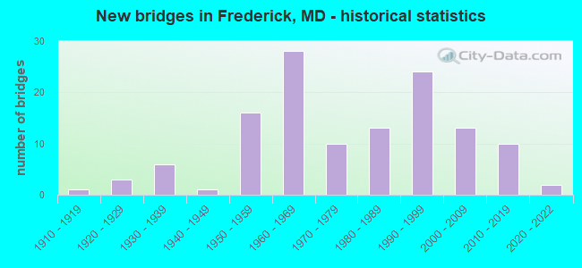
- New bridges - historical statistics
- 11910-1919
- 31920-1929
- 61930-1939
- 11940-1949
- 161950-1959
- 281960-1969
- 101970-1979
- 131980-1989
- 241990-1999
- 132000-2009
- 102010-2019
- 22020-2022

- Reconstructed bridges - Historical Statistics
- 21960-1969
- 21970-1979
- 101980-1989
- 51990-1999
- 32000-2009
- 32010-2019


- Bridge Condition - Deck
- 14.1%Very good
- 43.8%Good
- 29.7%Satisfactory
- 10.9%Fair
- 1.6%Poor

- Bridge Condition - Superstructure
- 17.4%Very good
- 37.7%Good
- 34.8%Satisfactory
- 5.8%Fair
- 4.3%Poor

- Bridge Condition - Substructure
- 13.0%Very good
- 42.0%Good
- 36.2%Satisfactory
- 7.2%Fair
- 1.4%Poor

- Bridge Condition - Channel
- 19.4%Very good
- 30.6%Good
- 37.5%Satisfactory
- 9.7%Fair
- 2.8%Poor

- Bridge Condition - Culverts
- 15.2%Very good
- 30.3%Good
- 45.5%Satisfactory
- 9.1%Fair
Find on map >> Show street view
Structure Number: 10000010002002, Location: 0.64 MILE NORTH OF US 40 (Lat: 39.423267, Lng: -77.429078), Route carried "on" structure: US 15, Year Built: 1958, Status: Open, Structure Length: 1.59m (5.22ft), Average Daily Traffic: 95,190 (year 2009), Truck Traffic: 8%, Average Future Daily Traffic: 132,830 (year 2029), Design Load: HS 20, Features Intersected: CARROLL CREEK
Minimum Vertical Clearance: 30+ m (98+ ft), Kilometerpoint: 21.351, Lanes on structure: 5, Base Highway Network: Yes, Owner: State Highway Agency, Approaching Roadway Width: 36.0m (118.1ft), Skew: 2 degrees, Material/Design: Concrete, Design/Construction: Culvert, Length of Maximum Span: 5.2m (17.1ft)
Condition: Channel: Satisfactory, Culverts: Satisfactory, Structural Evaluation: Equal to present minimum criteria, Waterway Adequacy: Equal to present desirable criteria, Approach Roadway Alignment: Equal to present desirable criteria, Designated Inspection Frequency: Every 24 months, Inspection Date: May 2020
Find on map >> Show street view
Structure Number: 100000100025013, Location: 0.2 MILE WEST OF MD 194 (Lat: 39.452269, Lng: -77.370922), Route carried "on" structure: State highway 26, Year Built: 1997, Status: Open, Structure Length: 10.03m (32.91ft), Average Daily Traffic: 16,275 (year 2018), Truck Traffic: 10%, Average Future Daily Traffic: 16,344 (year 2038), Design Load: HS 25 or greater, Features Intersected: MONOCACY RIVER
Minimum Vertical Clearance: 30+ m (98+ ft), Kilometerpoint: 3.167, Lanes on structure: 3, Base Highway Network: Yes, Owner: State Highway Agency, Approaching Roadway Width: 13.4m (44.0ft), Material/Design: Steel, Design/Construction: Stringer/Multi-beam, Number Of Spans In Main Unit: 2, Length of Maximum Span: 49.4m (162.1ft), Curb-To-Curb Width: 13.4m (44.0ft), Out-to-Out Width: 14.6m (47.9ft)
Condition: Deck: Good, Superstructure: Good, Substructure: Good, Channel: Very good, Inventory Rating: 55.3 metric tons, Method Used To Determine Inventory Rating: Load Factor (LF), Structural Evaluation: Better than present minimum criteria, Deck Geometry: Somewhat better than minimum adequacy, Waterway Adequacy: Equal to present desirable criteria, Approach Roadway Alignment: Equal to present desirable criteria, Designated Inspection Frequency: Every 24 months, Other Special Inspection Frequency: Every 12 months, Inspection Date: November 2021, Other Special Inspection Date: November 2021, Deck Structure Type: Concrete Cast-file-Place, Wearing Surface/Protective System: Wearing Surface: Monolithic Concrete, Deck Protection: Epoxy Coated Reinforcing
Find on map >> Show street view
Structure Number: 100000100025014, Location: 0.2 MILE WEST OF MD 194 (Lat: 39.452836, Lng: -77.370006), Route carried "on" structure: State highway 26, Year Built: 1932, Year Reconstructed: 1980, Status: Open, Structure Length: 9.85m (32.32ft), Average Daily Traffic: 16,275 (year 2018), Truck Traffic: 8%, Average Future Daily Traffic: 16,344 (year 2038), Design Load: H 20, Features Intersected: MONOCACY RIVER
Minimum Vertical Clearance: 4.57m (14.99ft), Kilometerpoint: 3.167, Lanes on structure: 2, Base Highway Network: Yes, Owner: State Highway Agency, Approaching Roadway Width: 12.2m (40.0ft), Material/Design: Steel, Design/Construction: Truss - Thru, Number Of Spans In Main Unit: 2, Length of Maximum Span: 48.8m (160.1ft), Curb-To-Curb Width: 8.2m (26.9ft), Out-to-Out Width: 8.7m (28.5ft)
Condition: Deck: Fair, Superstructure: Fair, Substructure: Satisfactory, Channel: Satisfactory, Operating Rating: 71.2 metric tons, Method Used To Determine Operating Rating: Load Factor (LF), Inventory Rating: 42.6 metric tons, Method Used To Determine Inventory Rating: Load Factor (LF), Structural Evaluation: Somewhat better than minimum adequacy, Deck Geometry: High priority of corrective action, Waterway Adequacy: Superior to present desirable criteria, Approach Roadway Alignment: Equal to present minimum criteria, Length Of Structure Improvement: 9.85m (32.32ft), Designated Inspection Frequency: Every 12 months, Critical Feature Inspection Frequency: Every 12 months, Inspection Date: May 2021, Critical Feature Inspection Date: May 2021, Bridge Improvement Cost: $552,000, Roadway Improvement Cost: $55,000, Total Project Cost: $607,000, Deck Structure Type: Concrete Cast-file-Place, Wearing Surface/Protective System: Wearing Surface: Bituminous
Find on map >> Show street view
Structure Number: 10000010003401, Location: 0.01 M E OF ROCK CREEK DR (Lat: 39.424808, Lng: -77.471306), Route carried "on" structure: US 40, Year Built: 1936, Status: Open, Structure Length: 1.28m (4.20ft), Average Daily Traffic: 20,782 (year 2009), Truck Traffic: 8%, Average Future Daily Traffic: 26,142 (year 2029), Features Intersected: ROCK CREEK
Minimum Vertical Clearance: 30+ m (98+ ft), Kilometerpoint: 17.812, Lanes on structure: 2, Base Highway Network: Yes, Owner: State Highway Agency, Approaching Roadway Width: 12.2m (40.0ft), Skew: 4 degrees, Material/Design: Concrete, Design/Construction: Tee Beam, Number Of Spans In Main Unit: 1, Length of Maximum Span: 11.0m (36.1ft), Curb-To-Curb Width: 12.2m (40.0ft), Out-to-Out Width: 13.4m (44.0ft)
Condition: Deck: Satisfactory, Superstructure: Satisfactory, Substructure: Fair, Channel: Poor, Operating Rating: 74.8 metric tons, Method Used To Determine Operating Rating: Load Factor (LF), Inventory Rating: 44.9 metric tons, Method Used To Determine Inventory Rating: Load Factor (LF), Structural Evaluation: Somewhat better than minimum adequacy, Deck Geometry: Better than present minimum criteria, Waterway Adequacy: Better than present minimum criteria, Approach Roadway Alignment: Equal to present desirable criteria, Designated Inspection Frequency: Every 24 months, Inspection Date: October 2020, Deck Structure Type: Concrete Cast-file-Place, Wearing Surface/Protective System: Wearing Surface: Monolithic Concrete
Find on map >> Show street view
Structure Number: 10000010003502, Location: .036 MILE EAST OF US 40AL (Lat: 39.419178, Lng: -77.459819), Route carried "on" structure: US 40, Year Built: 1947, Year Reconstructed: 1966, Status: Open, Structure Length: 1.32m (4.33ft), Average Daily Traffic: 47,332 (year 2009), Truck Traffic: 8%, Average Future Daily Traffic: 55,761 (year 2026), Design Load: H 20, Features Intersected: BRANCH OF ROCK CREEK
Minimum Vertical Clearance: 30+ m (98+ ft), Kilometerpoint: 19.012, Lanes on structure: 4, Base Highway Network: Yes, Owner: State Highway Agency, Approaching Roadway Width: 37.2m (122.0ft), Skew: 6 degrees, Material/Design: Concrete, Design/Construction: Culvert, Length of Maximum Span: 3.0m (9.8ft)
Condition: Channel: Satisfactory, Culverts: Satisfactory, Operating Rating: 48.5 metric tons, Method Used To Determine Operating Rating: Load Factor (LF), Inventory Rating: 29.0 metric tons, Method Used To Determine Inventory Rating: Load Factor (LF), Structural Evaluation: Equal to present minimum criteria, Waterway Adequacy: Equal to present minimum criteria, Approach Roadway Alignment: Equal to present desirable criteria, Designated Inspection Frequency: Every 24 months, Inspection Date: July 2021
Find on map >> Show street view
Structure Number: 10000010003601, Location: 0.02 M E OF BENTZ ST (Lat: 39.414003, Lng: -77.414622), Route carried "on" structure: State highway 144FA, Year Built: 1994, Status: Open, Structure Length: 3.17m (10.40ft), Average Daily Traffic: 6,861 (year 2018), Truck Traffic: 8%, Average Future Daily Traffic: 6,902 (year 2038), Design Load: HS 20, Features Intersected: CARROLL CREEK
Minimum Vertical Clearance: 30+ m (98+ ft), Kilometerpoint: 8.415, Lanes on structure: 2, Base Highway Network: Yes, Owner: State Highway Agency, Approaching Roadway Width: 7.9m (25.9ft), Skew: 1 degrees, Material/Design: Concrete, Design/Construction: Slab, Number Of Spans In Main Unit: 5, Number Of Approach Spans: 1, Length of Maximum Span: 6.4m (21.0ft), Curb or Sidewalk Widths: Left: 3.7m (12.1ft), Right: 3.7m (12.1ft), Curb-To-Curb Width: 7.9m (25.9ft), Out-to-Out Width: 15.9m (52.2ft)
Condition: Deck: Good, Superstructure: Good, Substructure: Good, Channel: Satisfactory, Inventory Rating: 65.3 metric tons, Method Used To Determine Inventory Rating: Load Factor (LF), Structural Evaluation: Better than present minimum criteria, Deck Geometry: High priority of replacement, Waterway Adequacy: Better than present minimum criteria, Approach Roadway Alignment: Equal to present desirable criteria, Designated Inspection Frequency: Every 24 months, Underwater Inspection Frequency: Every 48 months, Inspection Date: November 2020, Deck Structure Type: Concrete Cast-file-Place, Wearing Surface/Protective System: Wearing Surface: Monolithic Concrete, Deck Protection: Epoxy Coated Reinforcing
Find on map >> Show street view
Structure Number: 10000010003701, Location: 0.21 M E OF MARYLAND AVE (Lat: 39.413564, Lng: -77.401119), Route carried "on" structure: State highway 144FA, Year Built: 1995, Status: Open, Structure Length: 1.43m (4.69ft), Average Daily Traffic: 8,531 (year 2018), Truck Traffic: 8%, Average Future Daily Traffic: 8,582 (year 2038), Features Intersected: CARROLL CREEK
Minimum Vertical Clearance: 30+ m (98+ ft), Kilometerpoint: 7.208, Lanes on structure: 2, Base Highway Network: Yes, Owner: State Highway Agency, Approaching Roadway Width: 11.0m (36.1ft), Skew: 3 degrees, Material/Design: Concrete, Design/Construction: Culvert, Number Of Spans In Main Unit: 2, Length of Maximum Span: 6.1m (20.0ft), Curb or Sidewalk Widths: Left: 3.4m (11.2ft), Right: 1.9m (6.2ft), Curb-To-Curb Width: 7.9m (25.9ft), Out-to-Out Width: 15.2m (49.9ft)
Condition: Culverts: Good, Operating Rating: 73.5 metric tons, Method Used To Determine Operating Rating: Load Factor (LF), Inventory Rating: 44.0 metric tons, Method Used To Determine Inventory Rating: Load Factor (LF), Structural Evaluation: Better than present minimum criteria, Deck Geometry: High priority of replacement, Waterway Adequacy: Superior to present desirable criteria, Approach Roadway Alignment: Equal to present desirable criteria, Designated Inspection Frequency: Every 24 months, Underwater Inspection Frequency: Every 48 months, Inspection Date: November 2020, Deck Structure Type: Concrete Cast-file-Place, Wearing Surface/Protective System: Wearing Surface: Monolithic Concrete, Deck Protection: Epoxy Coated Reinforcing
Find on map >> Show street view
Structure Number: 100000100097011, Location: 0.15 MILE NORTH OF MD 26 (Lat: 39.443456, Lng: -77.403233), Route carried "on" structure: US 15, Year Built: 2018, Status: Open, Structure Length: 2.95m (9.68ft), Average Daily Traffic: 42,640 (year 2009), Truck Traffic: 8%, Average Future Daily Traffic: 61,480 (year 2029), Design Load: HS 20, Features Intersected: MD 26
Minimum Vertical Clearance: 30+ m (98+ ft), Kilometerpoint: 24.581, Lanes on structure: 2, Lanes under structure: 2, Base Highway Network: Yes, Owner: State Highway Agency, Approaching Roadway Width: 17.7m (58.1ft), Skew: 5 degrees, Material/Design: Steel, Design/Construction: Stringer/Multi-beam, Number Of Spans In Main Unit: 1, Length of Maximum Span: 28.0m (91.9ft), Curb-To-Curb Width: 18.5m (60.7ft), Out-to-Out Width: 19.7m (64.6ft)
Condition: Deck: Very good, Superstructure: Very good, Substructure: Very good, Operating Rating: 71.7 metric tons, Method Used To Determine Operating Rating: Load Factor (LF), Inventory Rating: 43.1 metric tons, Method Used To Determine Inventory Rating: Load Factor (LF), Structural Evaluation: Equal to present desirable criteria, Deck Geometry: Superior to present desirable criteria, Underclear: Meets minimum limits, Approach Roadway Alignment: Equal to present desirable criteria, Designated Inspection Frequency: Every 24 months, Inspection Date: August 2020, Deck Structure Type: Concrete Cast-file-Place, Wearing Surface/Protective System: Wearing Surface: Integral Concrete
Find on map >> Show street view
Structure Number: 100000100097012, Location: 0.15 MILE NORTH OF MD 26 (Lat: 39.443758, Lng: -77.403400), Route carried "on" structure: US 15, Year Built: 1968, Status: Open, Structure Length: 5.46m (17.91ft), Average Daily Traffic: 42,640 (year 2009), Truck Traffic: 8%, Average Future Daily Traffic: 61,480 (year 2029), Design Load: HS 20, Features Intersected: MD 26
Minimum Vertical Clearance: 30+ m (98+ ft), Kilometerpoint: 24.581, Lanes on structure: 2, Lanes under structure: 2, Base Highway Network: Yes, Owner: State Highway Agency, Approaching Roadway Width: 11.6m (38.1ft), Skew: 4 degrees, Material/Design: Steel, Design/Construction: Stringer/Multi-beam, Number Of Spans In Main Unit: 3, Length of Maximum Span: 26.8m (87.9ft), Curb-To-Curb Width: 11.9m (39.0ft), Out-to-Out Width: 13.1m (43.0ft)
Condition: Deck: Fair, Superstructure: Satisfactory, Substructure: Satisfactory, Operating Rating: 89.3 metric tons, Method Used To Determine Operating Rating: Load Factor (LF), Inventory Rating: 53.5 metric tons, Method Used To Determine Inventory Rating: Load Factor (LF), Structural Evaluation: Equal to present minimum criteria, Deck Geometry: Equal to present minimum criteria, Underclear: Meets minimum limits, Approach Roadway Alignment: Equal to present desirable criteria, Designated Inspection Frequency: Every 24 months, Inspection Date: August 2020, Deck Structure Type: Concrete Cast-file-Place, Wearing Surface/Protective System: Wearing Surface: Monolithic Concrete
Find on map >> Show street view
Structure Number: 10000010009801, Location: 0.53 MI S OF MD 26 (Lat: 39.435353, Lng: -77.410289), Route carried "on" structure: City street 1020, Year Built: 2014, Status: Open, Structure Length: 8.80m (28.87ft), Average Daily Traffic: 6,041 (year 2009), Truck Traffic: 5%, Average Future Daily Traffic: 10,100 (year 2030), Design Load: HS 20, Features Intersected: US 15, Facility Carried by Structure: MOTTER AVE
Minimum Vertical Clearance: 30+ m (98+ ft), Kilometerpoint: 1.094, Lanes on structure: 6, Lanes under structure: 6, Owner: State Highway Agency, Approaching Roadway Width: 25.3m (83.0ft), Skew: 4 degrees, Material/Design: Steel continuous, Design/Construction: Stringer/Multi-beam, Number Of Spans In Main Unit: 2, Length of Maximum Span: 44.2m (145.0ft), Curb or Sidewalk Widths: Left: 1.7m (5.6ft), Right: 1.7m (5.6ft), Curb-To-Curb Width: 25.3m (83.0ft), Out-to-Out Width: 29.7m (97.4ft)
Condition: Deck: Good, Superstructure: Very good, Substructure: Good, Operating Rating: 89.3 metric tons, Method Used To Determine Operating Rating: Load Factor (LF), Inventory Rating: 53.5 metric tons, Method Used To Determine Inventory Rating: Load Factor (LF), Structural Evaluation: Better than present minimum criteria, Deck Geometry: Somewhat better than minimum adequacy, Underclear: Better than present minimum criteria, Approach Roadway Alignment: Equal to present desirable criteria, Length Of Structure Improvement: 7.80m (25.59ft), Designated Inspection Frequency: Every 24 months, Inspection Date: September 2020, Bridge Improvement Cost: $1,665,000, Roadway Improvement Cost: $166,000, Total Project Cost: $1,832,000, Deck Structure Type: Concrete Cast-file-Place, Wearing Surface/Protective System: Wearing Surface: Monolithic Concrete
Find on map >> Show street view
Structure Number: 100000100099011, Location: 1.28 MILES NORTH OF US 40 (Lat: 39.428597, Lng: -77.419753), Route carried "on" structure: US 15, Year Built: 1958, Year Reconstructed: 1992, Status: Open, Structure Length: 3.69m (12.11ft), Average Daily Traffic: 83,230 (year 2009), Truck Traffic: 11%, Average Future Daily Traffic: 133,130 (year 2029), Design Load: HS 20, Features Intersected: WEST SEVENTH ST
Minimum Vertical Clearance: 30+ m (98+ ft), Kilometerpoint: 22.363, Lanes on structure: 3, Lanes under structure: 4, Base Highway Network: Yes, Owner: State Highway Agency, Approaching Roadway Width: 13.4m (44.0ft), Material/Design: Steel, Design/Construction: Stringer/Multi-beam, Number Of Spans In Main Unit: 3, Length of Maximum Span: 19.2m (63.0ft), Curb-To-Curb Width: 13.3m (43.6ft), Out-to-Out Width: 14.5m (47.6ft)
Condition: Deck: Satisfactory, Superstructure: Satisfactory, Substructure: Satisfactory, Operating Rating: 77.1 metric tons, Method Used To Determine Operating Rating: Load Factor (LF), Inventory Rating: 46.3 metric tons, Method Used To Determine Inventory Rating: Load Factor (LF), Structural Evaluation: Equal to present minimum criteria, Deck Geometry: High priority of replacement, Underclear: Equal to present minimum criteria, Approach Roadway Alignment: Equal to present desirable criteria, Length Of Structure Improvement: 3.69m (12.11ft), Designated Inspection Frequency: Every 24 months, Inspection Date: January 2022, Bridge Improvement Cost: $345,000, Roadway Improvement Cost: $34,000, Total Project Cost: $380,000, Deck Structure Type: Concrete Cast-file-Place, Wearing Surface/Protective System: Wearing Surface: Integral Concrete, Deck Protection: Epoxy Coated Reinforcing
Find on map >> Show street view
Structure Number: 100000100099012, Location: 1.28 MILES NORTH OF US 40 (Lat: 39.428939, Lng: -77.419569), Route carried "on" structure: US 15, Year Built: 1968, Status: Open, Structure Length: 3.69m (12.11ft), Average Daily Traffic: 83,230 (year 2009), Truck Traffic: 8%, Average Future Daily Traffic: 133,130 (year 2029), Design Load: HS 20, Features Intersected: WEST SEVENTH ST
Minimum Vertical Clearance: 30+ m (98+ ft), Kilometerpoint: 22.363, Lanes on structure: 3, Lanes under structure: 4, Base Highway Network: Yes, Owner: State Highway Agency, Approaching Roadway Width: 11.6m (38.1ft), Material/Design: Steel, Design/Construction: Stringer/Multi-beam, Number Of Spans In Main Unit: 3, Length of Maximum Span: 19.2m (63.0ft), Curb-To-Curb Width: 14.0m (45.9ft), Out-to-Out Width: 15.1m (49.5ft)
Condition: Deck: Fair, Superstructure: Satisfactory, Substructure: Satisfactory, Operating Rating: 76.2 metric tons, Method Used To Determine Operating Rating: Load Factor (LF), Inventory Rating: 45.4 metric tons, Method Used To Determine Inventory Rating: Load Factor (LF), Structural Evaluation: Equal to present minimum criteria, Deck Geometry: Meets minimum limits, Underclear: Meets minimum limits, Approach Roadway Alignment: Equal to present desirable criteria, Designated Inspection Frequency: Every 24 months, Inspection Date: January 2022, Deck Structure Type: Concrete Cast-file-Place, Wearing Surface/Protective System: Wearing Surface: Monolithic Concrete
Find on map >> Show street view
Structure Number: 100000100100011, Location: 0.77 MILE NORTH OF US 40 (Lat: 39.424264, Lng: -77.427347), Route carried "on" structure: US 15, Year Built: 1958, Year Reconstructed: 1992, Status: Open, Structure Length: 4.21m (13.81ft), Average Daily Traffic: 93,930 (year 2009), Truck Traffic: 11%, Average Future Daily Traffic: 133,130 (year 2029), Design Load: HS 20, Features Intersected: ROSEMONT AVE
Minimum Vertical Clearance: 30+ m (98+ ft), Kilometerpoint: 21.538, Lanes on structure: 3, Lanes under structure: 2, Base Highway Network: Yes, Owner: State Highway Agency, Approaching Roadway Width: 13.4m (44.0ft), Skew: 1 degrees, Material/Design: Steel, Design/Construction: Stringer/Multi-beam, Number Of Spans In Main Unit: 3, Length of Maximum Span: 21.3m (69.9ft), Curb-To-Curb Width: 13.3m (43.6ft), Out-to-Out Width: 14.5m (47.6ft)
Condition: Deck: Satisfactory, Superstructure: Satisfactory, Substructure: Satisfactory, Operating Rating: 81.6 metric tons, Method Used To Determine Operating Rating: Load Factor (LF), Inventory Rating: 49.0 metric tons, Method Used To Determine Inventory Rating: Load Factor (LF), Structural Evaluation: Equal to present minimum criteria, Deck Geometry: High priority of replacement, Underclear: High priority of corrective action, Approach Roadway Alignment: Equal to present desirable criteria, Length Of Structure Improvement: 4.21m (13.81ft), Designated Inspection Frequency: Every 24 months, Inspection Date: August 2020, Bridge Improvement Cost: $393,000, Roadway Improvement Cost: $39,000, Total Project Cost: $432,000, Deck Structure Type: Concrete Cast-file-Place, Wearing Surface/Protective System: Wearing Surface: Integral Concrete, Deck Protection: Epoxy Coated Reinforcing
Find on map >> Show street view
Structure Number: 100000100100012, Location: 0.77 MILE NORTH OF US 40 (Lat: 39.424608, Lng: -77.427150), Route carried "on" structure: US 15, Year Built: 1968, Status: Open, Structure Length: 4.24m (13.91ft), Average Daily Traffic: 93,930 (year 2009), Truck Traffic: 8%, Average Future Daily Traffic: 133,130 (year 2029), Design Load: HS 20, Features Intersected: ROSEMONT AVE
Minimum Vertical Clearance: 30+ m (98+ ft), Kilometerpoint: 21.538, Lanes on structure: 3, Lanes under structure: 2, Base Highway Network: Yes, Owner: State Highway Agency, Approaching Roadway Width: 15.2m (49.9ft), Skew: 1 degrees, Material/Design: Steel, Design/Construction: Stringer/Multi-beam, Number Of Spans In Main Unit: 3, Length of Maximum Span: 21.0m (68.9ft), Curb-To-Curb Width: 14.0m (45.9ft), Out-to-Out Width: 15.1m (49.5ft)
Condition: Deck: Satisfactory, Superstructure: Satisfactory, Substructure: Satisfactory, Operating Rating: 68.0 metric tons, Method Used To Determine Operating Rating: Load Factor (LF), Inventory Rating: 40.8 metric tons, Method Used To Determine Inventory Rating: Load Factor (LF), Structural Evaluation: Equal to present minimum criteria, Deck Geometry: Meets minimum limits, Underclear: High priority of corrective action, Approach Roadway Alignment: Equal to present desirable criteria, Designated Inspection Frequency: Every 24 months, Inspection Date: August 2020, Deck Structure Type: Concrete Cast-file-Place, Wearing Surface/Protective System: Wearing Surface: Monolithic Concrete
Find on map >> Show street view
Structure Number: 100000100101011, Location: 1.09 MILES N OF MD 180 (Lat: 39.415117, Lng: -77.434906), Route carried "on" structure: US 15, Year Built: 1958, Year Reconstructed: 1992, Status: Open, Structure Length: 5.03m (16.50ft), Average Daily Traffic: 95,190 (year 2009), Truck Traffic: 11%, Average Future Daily Traffic: 132,830 (year 2029), Design Load: HS 20, Features Intersected: US 40/W. PATRICK STREET
Minimum Vertical Clearance: 30+ m (98+ ft), Kilometerpoint: 20.325, Lanes on structure: 3, Lanes under structure: 6, Base Highway Network: Yes, Owner: State Highway Agency, Approaching Roadway Width: 15.2m (49.9ft), Material/Design: Steel, Design/Construction: Stringer/Multi-beam, Number Of Spans In Main Unit: 4, Length of Maximum Span: 15.5m (50.9ft), Curb-To-Curb Width: 14.3m (46.9ft), Out-to-Out Width: 15.5m (50.9ft)
Condition: Deck: Satisfactory, Superstructure: Good, Substructure: Satisfactory, Operating Rating: 79.4 metric tons, Method Used To Determine Operating Rating: Load Factor (LF), Inventory Rating: 47.6 metric tons, Method Used To Determine Inventory Rating: Load Factor (LF), Structural Evaluation: Equal to present minimum criteria, Deck Geometry: Meets minimum limits, Underclear: High priority of corrective action, Approach Roadway Alignment: Equal to present desirable criteria, Designated Inspection Frequency: Every 24 months, Inspection Date: January 2022, Deck Structure Type: Concrete Cast-file-Place, Wearing Surface/Protective System: Wearing Surface: Integral Concrete, Deck Protection: Epoxy Coated Reinforcing
Find on map >> Show street view
Structure Number: 100000100101012, Location: 1.09 MILES N OF MD 180 (Lat: 39.415592, Lng: -77.435019), Route carried "on" structure: US 15, Year Built: 1958, Year Reconstructed: 1992, Status: Open, Structure Length: 5.03m (16.50ft), Average Daily Traffic: 95,190 (year 2009), Truck Traffic: 11%, Average Future Daily Traffic: 132,830 (year 2029), Design Load: HS 20, Features Intersected: US 40/W. PATRICK STREET
Minimum Vertical Clearance: 30+ m (98+ ft), Kilometerpoint: 20.325, Lanes on structure: 3, Lanes under structure: 6, Base Highway Network: Yes, Owner: State Highway Agency, Approaching Roadway Width: 15.2m (49.9ft), Material/Design: Steel, Design/Construction: Stringer/Multi-beam, Number Of Spans In Main Unit: 4, Length of Maximum Span: 15.5m (50.9ft), Curb-To-Curb Width: 14.3m (46.9ft), Out-to-Out Width: 15.5m (50.9ft)
Condition: Deck: Satisfactory, Superstructure: Good, Substructure: Satisfactory, Operating Rating: 79.4 metric tons, Method Used To Determine Operating Rating: Load Factor (LF), Inventory Rating: 47.6 metric tons, Method Used To Determine Inventory Rating: Load Factor (LF), Structural Evaluation: Equal to present minimum criteria, Deck Geometry: Meets minimum limits, Underclear: Meets minimum limits, Approach Roadway Alignment: Equal to present desirable criteria, Designated Inspection Frequency: Every 24 months, Inspection Date: January 2020, Deck Structure Type: Concrete Cast-file-Place, Wearing Surface/Protective System: Wearing Surface: Integral Concrete, Deck Protection: Epoxy Coated Reinforcing
Find on map >> Show street view
Structure Number: 10000010010201, Location: 0.39 MILE NORTH OF MD 180 (Lat: 39.405847, Lng: -77.433222), Route carried "on" structure: US 15B, Year Built: 1955, Status: Open, Structure Length: 6.86m (22.51ft), Average Daily Traffic: 45,900 (year 2006), Truck Traffic: 8%, Average Future Daily Traffic: 52,923 (year 2026), Design Load: HS 20, Features Intersected: US 15/US 40
Minimum Vertical Clearance: 30+ m (98+ ft), Kilometerpoint: 0.000, Lanes on structure: 6, Lanes under structure: 6, Base Highway Network: Yes, Owner: State Highway Agency, Approaching Roadway Width: 28.7m (94.2ft), Skew: 21 degrees, Material/Design: Steel, Design/Construction: Stringer/Multi-beam, Number Of Spans In Main Unit: 4, Length of Maximum Span: 22.9m (75.1ft), Curb or Sidewalk Widths: Left: 0.9m (3.0ft), Right: 0.9m (3.0ft), Curb-To-Curb Width: 28.7m (94.2ft), Out-to-Out Width: 31.3m (102.7ft)
Condition: Deck: Good, Superstructure: Good, Substructure: Good, Operating Rating: 75.3 metric tons, Method Used To Determine Operating Rating: Load Factor (LF), Inventory Rating: 44.9 metric tons, Method Used To Determine Inventory Rating: Load Factor (LF), Structural Evaluation: Better than present minimum criteria, Deck Geometry: Better than present minimum criteria, Underclear: Somewhat better than minimum adequacy, Approach Roadway Alignment: Equal to present desirable criteria, Length Of Structure Improvement: 6.86m (22.51ft), Designated Inspection Frequency: Every 24 months, Inspection Date: August 2020, Bridge Improvement Cost: $1,385,000, Roadway Improvement Cost: $138,000, Total Project Cost: $1,524,000, Deck Structure Type: Concrete Cast-file-Place, Wearing Surface/Protective System: Wearing Surface: Bituminous
Find on map >> Show street view
Structure Number: 100000100106013, Location: 0.53 MI W OF MD 144 FA (Lat: 39.403750, Lng: -77.393914), Route carried "on" structure: Interstate 70, Year Built: 2013, Status: Open, Structure Length: 7.98m (26.18ft), Average Daily Traffic: 68,623 (year 2009), Truck Traffic: 10%, Average Future Daily Traffic: 110,100 (year 2020), Design Load: HS 25 or greater, Features Intersected: CSX TRANS AND SOUTH STRE
Minimum Vertical Clearance: 30+ m (98+ ft), Kilometerpoint: 26.294, Lanes on structure: 3, Lanes under structure: 2, Base Highway Network: Yes, Owner: State Highway Agency, Approaching Roadway Width: 152.4m (500.0ft), Material/Design: Steel continuous, Design/Construction: Stringer/Multi-beam, Number Of Spans In Main Unit: 2, Length of Maximum Span: 42.7m (140.1ft), Curb-To-Curb Width: 20.7m (67.9ft), Out-to-Out Width: 21.9m (71.9ft)
Condition: Deck: Very good, Superstructure: Very good, Substructure: Very good, Inventory Rating: 58.5 metric tons, Method Used To Determine Inventory Rating: Load Factor (LF), Structural Evaluation: Equal to present desirable criteria, Deck Geometry: Superior to present desirable criteria, Underclear: Equal to present minimum criteria, Approach Roadway Alignment: Equal to present desirable criteria, Designated Inspection Frequency: Every 24 months, Inspection Date: November 2021, Deck Structure Type: Concrete Cast-file-Place, Wearing Surface/Protective System: Wearing Surface: Bituminous
Find on map >> Show street view
Structure Number: 100000100106014, Location: 0.53 MI W OF MD 144 FA (Lat: 39.404075, Lng: -77.393483), Route carried "on" structure: Interstate 70, Year Built: 2013, Status: Open, Structure Length: 7.98m (26.18ft), Average Daily Traffic: 68,623 (year 2009), Truck Traffic: 8%, Average Future Daily Traffic: 110,100 (year 2020), Design Load: HS 20, Features Intersected: CSX TRANS AND SOUTH ST
Minimum Vertical Clearance: 30+ m (98+ ft), Kilometerpoint: 26.294, Lanes on structure: 3, Lanes under structure: 2, Base Highway Network: Yes, Owner: State Highway Agency, Approaching Roadway Width: 20.7m (67.9ft), Material/Design: Steel continuous, Design/Construction: Stringer/Multi-beam, Number Of Spans In Main Unit: 2, Length of Maximum Span: 42.7m (140.1ft), Curb-To-Curb Width: 20.7m (67.9ft), Out-to-Out Width: 21.9m (71.9ft)
Condition: Deck: Very good, Superstructure: Very good, Substructure: Very good, Inventory Rating: 58.5 metric tons, Method Used To Determine Inventory Rating: Load Factor (LF), Structural Evaluation: Equal to present desirable criteria, Deck Geometry: Superior to present desirable criteria, Underclear: Meets minimum limits, Approach Roadway Alignment: Equal to present desirable criteria, Designated Inspection Frequency: Every 24 months, Inspection Date: November 2021, Deck Structure Type: Concrete Cast-file-Place, Wearing Surface/Protective System: Wearing Surface: Bituminous
Find on map >> Show street view
Structure Number: 10000010011101, Location: 0.07 MI N OF POWELL RD (Lat: 39.533917, Lng: -77.423500), Route carried "on" structure: US 15, Year Built: 1961, Status: Open, Structure Length: 1.98m (6.50ft), Average Daily Traffic: 43,080 (year 2009), Truck Traffic: 8%, Average Future Daily Traffic: 25,382 (year 2026), Design Load: HS 20, Features Intersected: FISHING CREEK
Minimum Vertical Clearance: 30+ m (98+ ft), Kilometerpoint: 35.388, Lanes on structure: 2, Base Highway Network: Yes, Owner: State Highway Agency, Approaching Roadway Width: 13.4m (44.0ft), Material/Design: Concrete continuous, Design/Construction: Slab, Number Of Spans In Main Unit: 3, Length of Maximum Span: 6.7m (22.0ft), Curb-To-Curb Width: 13.4m (44.0ft), Out-to-Out Width: 15.1m (49.5ft)
Condition: Deck: Satisfactory, Superstructure: Satisfactory, Substructure: Satisfactory, Channel: Fair, Operating Rating: 54.4 metric tons, Method Used To Determine Operating Rating: Load Factor (LF), Inventory Rating: 32.7 metric tons, Method Used To Determine Inventory Rating: Load Factor (LF), Structural Evaluation: Equal to present minimum criteria, Deck Geometry: Superior to present desirable criteria, Waterway Adequacy: Better than present minimum criteria, Approach Roadway Alignment: Equal to present desirable criteria, Designated Inspection Frequency: Every 24 months, Inspection Date: September 2021, Deck Structure Type: Concrete Cast-file-Place, Wearing Surface/Protective System: Wearing Surface: Bituminous
Find on map >> Show street view
Structure Number: 10000010012301, Location: 0.32 M S OF BR NO 1013700 (Lat: 39.394792, Lng: -77.419950), Route carried "on" structure: Ramp Interstate 270, Year Built: 2002, Status: Open, Structure Length: 7.04m (23.10ft), Average Daily Traffic: 14,067 (year 2006), Truck Traffic: 8%, Average Future Daily Traffic: 15,192 (year 2026), Design Load: HS 25 or greater, Features Intersected: NEW DESIGN ROAD
Minimum Vertical Clearance: 30+ m (98+ ft), Kilometerpoint: 15.575, Lanes on structure: 3, Lanes under structure: 4, Base Highway Network: Yes, Owner: State Highway Agency, Approaching Roadway Width: 17.1m (56.1ft), Skew: 4 degrees, Material/Design: Steel continuous, Design/Construction: Stringer/Multi-beam, Number Of Spans In Main Unit: 3, Length of Maximum Span: 35.1m (115.2ft), Curb or Sidewalk Widths: Left: 0.6m (2.0ft), Right: 0.6m (2.0ft), Curb-To-Curb Width: 17.1m (56.1ft), Out-to-Out Width: 18.3m (60.0ft)
Condition: Deck: Good, Superstructure: Good, Substructure: Good, Inventory Rating: 68.0 metric tons, Method Used To Determine Inventory Rating: Load Factor (LF), Structural Evaluation: Better than present minimum criteria, Deck Geometry: Superior to present desirable criteria, Underclear: Equal to present minimum criteria, Approach Roadway Alignment: Equal to present desirable criteria, Designated Inspection Frequency: Every 24 months, Inspection Date: August 2020, Deck Structure Type: Concrete Cast-file-Place, Wearing Surface/Protective System: Wearing Surface: Integral Concrete, Deck Protection: Epoxy Coated Reinforcing
Find on map >> Show street view
Structure Number: 10000010012601, Location: 1.77 MI W OF MD 180 (Lat: 39.412622, Lng: -77.473717), Route carried "on" structure: County highway 226, Year Built: 1967, Year Reconstructed: 1973, Status: Open, Structure Length: 7.07m (23.20ft), Average Daily Traffic: 5,102 (year 2009), Truck Traffic: 5%, Average Future Daily Traffic: 9,962 (year 2029), Design Load: HS 15, Features Intersected: IS 70, Facility Carried by Structure: MT PHILLIP ROAD
Minimum Vertical Clearance: 30+ m (98+ ft), Kilometerpoint: 1.191, Lanes on structure: 2, Lanes under structure: 4, Owner: State Highway Agency, Approaching Roadway Width: 9.8m (32.2ft), Skew: 2 degrees, Material/Design: Steel continuous, Design/Construction: Stringer/Multi-beam, Number Of Spans In Main Unit: 2, Length of Maximum Span: 30.8m (101.0ft), Curb-To-Curb Width: 8.2m (26.9ft), Out-to-Out Width: 9.8m (32.2ft)
Condition: Deck: Satisfactory, Superstructure: Satisfactory, Substructure: Satisfactory, Operating Rating: 59.9 metric tons, Method Used To Determine Operating Rating: Load Factor (LF), Inventory Rating: 35.8 metric tons, Method Used To Determine Inventory Rating: Load Factor (LF), Structural Evaluation: Equal to present minimum criteria, Deck Geometry: High priority of corrective action, Underclear: Somewhat better than minimum adequacy, Approach Roadway Alignment: Equal to present desirable criteria, Length Of Structure Improvement: 7.07m (23.20ft), Designated Inspection Frequency: Every 24 months, Inspection Date: July 2020, Bridge Improvement Cost: $445,000, Roadway Improvement Cost: $44,000, Total Project Cost: $490,000, Deck Structure Type: Concrete Cast-file-Place, Wearing Surface/Protective System: Wearing Surface: Monolithic Concrete
Find on map >> Show street view
Structure Number: 100000100128013, Location: 0.02 MILE EAST OF US 15 (Lat: 0.000108, Lng: -0.000214), Route carried "on" structure: Interstate 70, Year Built: 1968, Year Reconstructed: 1997, Status: Open, Structure Length: 3.78m (12.40ft), Average Daily Traffic: 94,760 (year 2009), Truck Traffic: 8%, Average Future Daily Traffic: 46,623 (year 2022), Design Load: HS 20, Features Intersected: MD 180
Minimum Vertical Clearance: 30+ m (98+ ft), Kilometerpoint: 22.442, Lanes on structure: 2, Lanes under structure: 4, Base Highway Network: Yes, Owner: State Highway Agency, Approaching Roadway Width: 15.5m (50.9ft), Material/Design: Steel continuous, Design/Construction: Stringer/Multi-beam, Number Of Spans In Main Unit: 3, Length of Maximum Span: 14.3m (46.9ft), Curb-To-Curb Width: 15.1m (49.5ft), Out-to-Out Width: 16.5m (54.1ft)
Condition: Deck: Good, Superstructure: Satisfactory, Substructure: Good, Operating Rating: 76.2 metric tons, Method Used To Determine Operating Rating: Load Factor (LF), Inventory Rating: 45.4 metric tons, Method Used To Determine Inventory Rating: Load Factor (LF), Structural Evaluation: Equal to present minimum criteria, Deck Geometry: Superior to present desirable criteria, Underclear: Somewhat better than minimum adequacy, Approach Roadway Alignment: Equal to present desirable criteria, Designated Inspection Frequency: Every 24 months, Inspection Date: October 2021, Deck Structure Type: Concrete Cast-file-Place, Wearing Surface/Protective System: Wearing Surface: Latex Concrete
Find on map >> Show street view
Structure Number: 10000010013801, Location: 0.5 MILE EAST OF MD 180 (Lat: 39.399100, Lng: -77.426811), Route carried "on" structure: Interstate 70, Year Built: 2002, Status: Open, Structure Length: 4.11m (13.48ft), Average Daily Traffic: 94,760 (year 2009), Truck Traffic: 8%, Average Future Daily Traffic: 46,418 (year 2026), Design Load: HS 25 or greater, Features Intersected: US 40 EBR(RAMP 5)
Minimum Vertical Clearance: 30+ m (98+ ft), Kilometerpoint: 23.266, Lanes on structure: 6, Lanes under structure: 2, Base Highway Network: Yes, Owner: State Highway Agency, Approaching Roadway Width: 36.6m (120.1ft), Skew: 1 degrees, Material/Design: Steel, Design/Construction: Stringer/Multi-beam, Number Of Spans In Main Unit: 1, Length of Maximum Span: 41.1m (134.8ft), Curb or Sidewalk Widths: Left: 0.6m (2.0ft), Right: 0.6m (2.0ft), Curb-To-Curb Width: 28.0m (91.9ft), Out-to-Out Width: 29.3m (96.1ft)
Condition: Deck: Good, Superstructure: Very good, Substructure: Good, Operating Rating: 75.7 metric tons, Method Used To Determine Operating Rating: Load Factor (LF), Inventory Rating: 45.4 metric tons, Method Used To Determine Inventory Rating: Load Factor (LF), Structural Evaluation: Better than present minimum criteria, Deck Geometry: Equal to present minimum criteria, Underclear: Equal to present desirable criteria, Approach Roadway Alignment: Equal to present desirable criteria, Designated Inspection Frequency: Every 24 months, Inspection Date: October 2020, Deck Structure Type: Concrete Cast-file-Place, Wearing Surface/Protective System: Wearing Surface: Integral Concrete, Deck Protection: Epoxy Coated Reinforcing
Find on map >> Show street view
Structure Number: 10000010014001, Location: 0.2 MILE EAST OF US 15 (Lat: 39.399069, Lng: -77.437358), Route carried "on" structure: Ramp Interstate 70, Year Built: 1968, Year Reconstructed: 1996, Status: Open, Structure Length: 3.84m (12.60ft), Average Daily Traffic: 12,984 (year 2006), Truck Traffic: 8%, Average Future Daily Traffic: 14,971 (year 2026), Design Load: HS 20, Features Intersected: MD 180
Minimum Vertical Clearance: 30+ m (98+ ft), Kilometerpoint: 0.196, Lanes on structure: 2, Lanes under structure: 2, Base Highway Network: Yes, Owner: State Highway Agency, Approaching Roadway Width: 13.7m (44.9ft), Skew: 2 degrees, Material/Design: Steel continuous, Design/Construction: Stringer/Multi-beam, Number Of Spans In Main Unit: 3, Length of Maximum Span: 15.2m (49.9ft), Curb-To-Curb Width: 13.4m (44.0ft), Out-to-Out Width: 14.6m (47.9ft)
Condition: Deck: Good, Superstructure: Satisfactory, Substructure: Good, Operating Rating: 75.7 metric tons, Method Used To Determine Operating Rating: Load Factor (LF), Inventory Rating: 45.4 metric tons, Method Used To Determine Inventory Rating: Load Factor (LF), Structural Evaluation: Equal to present minimum criteria, Deck Geometry: Superior to present desirable criteria, Underclear: Somewhat better than minimum adequacy, Approach Roadway Alignment: Equal to present minimum criteria, Designated Inspection Frequency: Every 24 months, Inspection Date: October 2021, Deck Structure Type: Concrete Cast-file-Place, Wearing Surface/Protective System: Wearing Surface: Monolithic Concrete, Deck Protection: Epoxy Coated Reinforcing
Find on map >> Show street view
Structure Number: 100000100141013, Location: 0.37 MILE EAST OF MD 180 (Lat: 39.676108, Lng: -77.736158), Route carried "on" structure: Interstate 70, Year Built: 1968, Year Reconstructed: 1996, Status: Open, Structure Length: 6.07m (19.91ft), Average Daily Traffic: 89,580 (year 2016), Truck Traffic: 8%, Average Future Daily Traffic: 114,844 (year 2036), Design Load: HS 20, Features Intersected: US 15
Minimum Vertical Clearance: 30+ m (98+ ft), Kilometerpoint: 22.108, Lanes on structure: 3, Lanes under structure: 5, Base Highway Network: Yes, Owner: State Highway Agency, Approaching Roadway Width: 14.9m (48.9ft), Material/Design: Steel continuous, Design/Construction: Stringer/Multi-beam, Number Of Spans In Main Unit: 2, Length of Maximum Span: 29.6m (97.1ft), Curb-To-Curb Width: 14.9m (48.9ft), Out-to-Out Width: 16.2m (53.1ft)
Condition: Deck: Satisfactory, Superstructure: Satisfactory, Substructure: Satisfactory, Operating Rating: 78.9 metric tons, Method Used To Determine Operating Rating: Load Factor (LF), Inventory Rating: 47.2 metric tons, Method Used To Determine Inventory Rating: Load Factor (LF), Structural Evaluation: Equal to present minimum criteria, Deck Geometry: Meets minimum limits, Underclear: Somewhat better than minimum adequacy, Approach Roadway Alignment: Equal to present desirable criteria, Designated Inspection Frequency: Every 24 months, Inspection Date: May 2020, Deck Structure Type: Concrete Cast-file-Place, Wearing Surface/Protective System: Wearing Surface: Monolithic Concrete, Deck Protection: Epoxy Coated Reinforcing
Find on map >> Show street view
Structure Number: 100000100142013, Location: 0.28 MILE EAST OF MD 180 (Lat: 39.677403, Lng: -77.739672), Route carried "on" structure: Interstate 70, Year Built: 1968, Year Reconstructed: 1996, Status: Open, Structure Length: 2.38m (7.81ft), Average Daily Traffic: 78,360 (year 2018), Truck Traffic: 8%, Average Future Daily Traffic: 86,580 (year 2038), Design Load: HS 20+Mod, Features Intersected: IS 70 RAMP 'A'
Minimum Vertical Clearance: 30+ m (98+ ft), Kilometerpoint: 21.982, Lanes on structure: 2, Lanes under structure: 1, Base Highway Network: Yes, Owner: State Highway Agency, Approaching Roadway Width: 11.6m (38.1ft), Material/Design: Steel, Design/Construction: Stringer/Multi-beam, Number Of Spans In Main Unit: 1, Length of Maximum Span: 22.6m (74.1ft), Curb-To-Curb Width: 11.4m (37.4ft), Out-to-Out Width: 12.8m (42.0ft)
Condition: Deck: Satisfactory, Superstructure: Satisfactory, Substructure: Satisfactory, Inventory Rating: 56.2 metric tons, Method Used To Determine Inventory Rating: Load Factor (LF), Structural Evaluation: Equal to present minimum criteria, Deck Geometry: Somewhat better than minimum adequacy, Underclear: Equal to present desirable criteria, Approach Roadway Alignment: Equal to present desirable criteria, Designated Inspection Frequency: Every 24 months, Inspection Date: January 2022, Deck Structure Type: Concrete Cast-file-Place, Wearing Surface/Protective System: Wearing Surface: Latex Concrete
Find on map >> Show street view
Structure Number: 10000010014301, Location: 0.37 MILE EAST OF MD 180 (Lat: 39.668369, Lng: -77.744117), Route carried "on" structure: Ramp Interstate 70, Year Built: 1968, Year Reconstructed: 1998, Status: Open, Structure Length: 5.58m (18.31ft), Average Daily Traffic: 13,542 (year 2016), Truck Traffic: 8%, Average Future Daily Traffic: 17,361 (year 2036), Design Load: HS 20, Features Intersected: US 15/US 340
Minimum Vertical Clearance: 30+ m (98+ ft), Kilometerpoint: 0.418, Lanes on structure: 2, Lanes under structure: 6, Base Highway Network: Yes, Owner: State Highway Agency, Approaching Roadway Width: 12.2m (40.0ft), Skew: 1 degrees, Material/Design: Steel continuous, Design/Construction: Stringer/Multi-beam, Number Of Spans In Main Unit: 2, Length of Maximum Span: 28.3m (92.8ft), Curb-To-Curb Width: 12.4m (40.7ft), Out-to-Out Width: 13.7m (44.9ft)
Condition: Deck: Good, Superstructure: Satisfactory, Substructure: Satisfactory, Operating Rating: 50.3 metric tons, Method Used To Determine Operating Rating: Load Factor (LF), Inventory Rating: 29.5 metric tons, Method Used To Determine Inventory Rating: Load Factor (LF), Structural Evaluation: Equal to present minimum criteria, Deck Geometry: Superior to present desirable criteria, Underclear: High priority of corrective action, Approach Roadway Alignment: Equal to present desirable criteria, Designated Inspection Frequency: Every 24 months, Inspection Date: May 2020, Deck Structure Type: Concrete Cast-file-Place, Wearing Surface/Protective System: Wearing Surface: Latex Concrete, Deck Protection: Epoxy Coated Reinforcing
Find on map >> Show street view
Structure Number: 10000010014802, Location: 0.28 M W OF BOWERS ROAD (Lat: 39.426183, Lng: -77.478889), Route carried "on" structure: US 40, Year Built: 1969, Status: Open, Structure Length: 0.76m (2.49ft), Average Daily Traffic: 25 (year 2013), Truck Traffic: 8%, Average Future Daily Traffic: 50 (year 2029), Design Load: HS 20, Features Intersected: ROCK CREEK
Minimum Vertical Clearance: 30+ m (98+ ft), Kilometerpoint: 17.152, Lanes on structure: 2, Base Highway Network: Yes, Owner: State Highway Agency, Approaching Roadway Width: 9.8m (32.2ft), Material/Design: Concrete, Design/Construction: Culvert, Length of Maximum Span: 3.7m (12.1ft)
Condition: Channel: Poor, Culverts: Satisfactory, Operating Rating: 32.7 metric tons, Method Used To Determine Operating Rating: Field evaluation and documented engineering judgment, Inventory Rating: 32.7 metric tons, Method Used To Determine Inventory Rating: Field evaluation and documented engineering judgment, Structural Evaluation: Equal to present minimum criteria, Waterway Adequacy: Better than present minimum criteria, Approach Roadway Alignment: Equal to present desirable criteria, Designated Inspection Frequency: Every 24 months, Inspection Date: April 2021
Find on map >> Show street view
Structure Number: 100000100149013, Location: 0.49 MILE EAST OF IS 70 (Lat: 39.401983, Lng: -77.437844), Route carried "on" structure: State highway 180, Year Built: 2020, Status: Open, Structure Length: 8.43m (27.66ft), Average Daily Traffic: 27,750 (year 2015), Truck Traffic: 4%, Average Future Daily Traffic: 41,011 (year 2030), Features Intersected: US 15
Minimum Vertical Clearance: 30+ m (98+ ft), Kilometerpoint: 23.314, Lanes on structure: 2, Lanes under structure: 6, Owner: State Highway Agency, Approaching Roadway Width: 9.8m (32.2ft), Skew: 1 degrees, Material/Design: Steel continuous, Design/Construction: Stringer/Multi-beam, Number Of Spans In Main Unit: 3, Length of Maximum Span: 28.3m (92.8ft), Curb or Sidewalk Widths: Left: 0.0m, Right: 2.7m (8.9ft), Curb-To-Curb Width: 9.8m (32.2ft), Out-to-Out Width: 12.6m (41.3ft)
Condition: Deck: Very good, Superstructure: Very good, Substructure: Very good, Operating Rating: 76.5 metric tons, Method Used To Determine Operating Rating: Load and Resistance Factor Rating (LRFR) rating reported by rating factor(RF) method using HL-93 loadings, Inventory Rating: 59.0 metric tons, Method Used To Determine Inventory Rating: Load and Resistance Factor Rating (LRFR) rating reported by rating factor(RF) method using HL-93 loadings, Structural Evaluation: Equal to present desirable criteria, Deck Geometry: Meets minimum limits, Underclear: Equal to present minimum criteria, Approach Roadway Alignment: Equal to present desirable criteria, Length Of Structure Improvement: 111.04m (364.30ft), Designated Inspection Frequency: Every 24 months, Inspection Date: December 2020, Deck Structure Type: Concrete Cast-file-Place, Wearing Surface/Protective System: Wearing Surface: Monolithic Concrete
Find on map >> Show street view
Structure Number: 100000100149014, Location: 0.49 MILE EAST OF IS 70 (Lat: 39.401983, Lng: -77.437844), Route carried "on" structure: State highway 180, Year Built: 1968, Status: Open, Structure Length: 8.20m (26.90ft), Average Daily Traffic: 27,750 (year 2015), Truck Traffic: 4%, Average Future Daily Traffic: 410,110 (year 2030), Design Load: HS 20, Features Intersected: US 15
Minimum Vertical Clearance: 30+ m (98+ ft), Kilometerpoint: 23.314, Lanes on structure: 2, Lanes under structure: 6, Owner: State Highway Agency, Approaching Roadway Width: 9.8m (32.2ft), Skew: 1 degrees, Material/Design: Steel continuous, Design/Construction: Stringer/Multi-beam, Number Of Spans In Main Unit: 3, Length of Maximum Span: 28.0m (91.9ft), Curb-To-Curb Width: 9.4m (30.8ft), Out-to-Out Width: 11.0m (36.1ft)
Condition: Deck: Fair, Superstructure: Satisfactory, Substructure: Satisfactory, Operating Rating: 76.2 metric tons, Method Used To Determine Operating Rating: Load Factor (LF), Inventory Rating: 45.4 metric tons, Method Used To Determine Inventory Rating: Load Factor (LF), Structural Evaluation: Equal to present minimum criteria, Deck Geometry: Meets minimum limits, Underclear: Equal to present minimum criteria, Approach Roadway Alignment: Equal to present desirable criteria, Designated Inspection Frequency: Every 24 months, Inspection Date: December 2020, Deck Structure Type: Concrete Cast-file-Place, Wearing Surface/Protective System: Wearing Surface: Monolithic Concrete
Find on map >> Show street view
Structure Number: 10000010015801, Location: 0.07 MI N OF POWELL RD (Lat: 39.534025, Lng: -77.423883), Route carried "on" structure: US 15, Year Built: 1972, Status: Open, Structure Length: 2.01m (6.59ft), Average Daily Traffic: 43,080 (year 2009), Truck Traffic: 8%, Average Future Daily Traffic: 25,382 (year 2026), Design Load: HS 20, Features Intersected: FISHING CREEK
Minimum Vertical Clearance: 30+ m (98+ ft), Kilometerpoint: 35.388, Lanes on structure: 2, Base Highway Network: Yes, Owner: State Highway Agency, Approaching Roadway Width: 11.6m (38.1ft), Material/Design: Concrete continuous, Design/Construction: Slab, Number Of Spans In Main Unit: 3, Length of Maximum Span: 6.7m (22.0ft), Curb-To-Curb Width: 12.0m (39.4ft), Out-to-Out Width: 13.0m (42.7ft)
Condition: Deck: Satisfactory, Superstructure: Satisfactory, Substructure: Satisfactory, Channel: Satisfactory, Operating Rating: 37.6 metric tons, Method Used To Determine Operating Rating: Load Factor (LF), Inventory Rating: 22.2 metric tons, Method Used To Determine Inventory Rating: Load Factor (LF), Structural Evaluation: Somewhat better than minimum adequacy, Deck Geometry: Better than present minimum criteria, Waterway Adequacy: Equal to present desirable criteria, Approach Roadway Alignment: Equal to present desirable criteria, Designated Inspection Frequency: Every 24 months, Inspection Date: September 2021, Deck Structure Type: Concrete Cast-file-Place, Wearing Surface/Protective System: Wearing Surface: Monolithic Concrete
Find on map >> Show street view
Structure Number: 10000010019001, Location: I-70/MD 351 INTERCHANGE (Lat: 39.397692, Lng: -77.437589), Route carried "on" structure: Ramp Interstate 70, Year Built: 1996, Status: Open, Structure Length: 3.20m (10.50ft), Average Daily Traffic: 12,602 (year 2006), Average Future Daily Traffic: 14,530 (year 2026), Design Load: HS 25 or greater, Features Intersected: MD 180
Minimum Vertical Clearance: 30+ m (98+ ft), Kilometerpoint: 0.685, Lanes on structure: 2, Lanes under structure: 2, Base Highway Network: Yes, Owner: State Highway Agency, Approaching Roadway Width: 86.6m (284.1ft), Skew: 6 degrees, Material/Design: Steel, Design/Construction: Stringer/Multi-beam, Number Of Spans In Main Unit: 1, Length of Maximum Span: 30.5m (100.1ft), Curb or Sidewalk Widths: Left: 0.6m (2.0ft), Right: 0.6m (2.0ft), Curb-To-Curb Width: 11.9m (39.0ft), Out-to-Out Width: 13.1m (43.0ft)
Condition: Deck: Good, Superstructure: Good, Substructure: Satisfactory, Operating Rating: 79.8 metric tons, Method Used To Determine Operating Rating: Load Factor (LF), Inventory Rating: 48.1 metric tons, Method Used To Determine Inventory Rating: Load Factor (LF), Structural Evaluation: Equal to present minimum criteria, Deck Geometry: Superior to present desirable criteria, Underclear: Somewhat better than minimum adequacy, Approach Roadway Alignment: Equal to present desirable criteria, Designated Inspection Frequency: Every 24 months, Inspection Date: October 2021, Deck Structure Type: Concrete Cast-file-Place, Wearing Surface/Protective System: Wearing Surface: Monolithic Concrete, Deck Protection: Epoxy Coated Reinforcing
Find on map >> Show street view
Structure Number: 10000010019301, Location: 0.46 MILE NORTH OF IS 70 (Lat: 39.400642, Lng: -77.427903), Route carried "on" structure: Ramp Interstate 70, Year Built: 2002, Status: Open, Structure Length: 3.78m (12.40ft), Average Daily Traffic: 3,723 (year 2006), Truck Traffic: 8%, Average Future Daily Traffic: 4,021 (year 2026), Design Load: HS 25 or greater, Features Intersected: US 40 RAMP '5'
Minimum Vertical Clearance: 30+ m (98+ ft), Kilometerpoint: 0.389, Lanes on structure: 1, Lanes under structure: 2, Base Highway Network: Yes, Owner: State Highway Agency, Approaching Roadway Width: 7.6m (24.9ft), Material/Design: Steel, Design/Construction: Stringer/Multi-beam, Number Of Spans In Main Unit: 1, Length of Maximum Span: 36.3m (119.1ft), Curb or Sidewalk Widths: Left: 0.6m (2.0ft), Right: 0.6m (2.0ft), Curb-To-Curb Width: 8.2m (26.9ft), Out-to-Out Width: 9.4m (30.8ft)
Condition: Deck: Good, Superstructure: Very good, Substructure: Good, Inventory Rating: 82.5 metric tons, Method Used To Determine Inventory Rating: Load Factor (LF), Structural Evaluation: Better than present minimum criteria, Deck Geometry: Superior to present desirable criteria, Underclear: Somewhat better than minimum adequacy, Approach Roadway Alignment: Equal to present desirable criteria, Designated Inspection Frequency: Every 24 months, Inspection Date: October 2020, Deck Structure Type: Concrete Cast-file-Place, Wearing Surface/Protective System: Wearing Surface: Integral Concrete, Deck Protection: Epoxy Coated Reinforcing
Find on map >> Show street view
Structure Number: 10000010019501, Location: AT IS 70 (Lat: 39.401175, Lng: -77.403606), Route carried "on" structure: State highway 85, Year Built: 2009, Status: Open, Structure Length: 5.24m (17.19ft), Average Daily Traffic: 35,962 (year 2018), Average Future Daily Traffic: 36,115 (year 2038), Design Load: HS 25 or greater, Features Intersected: IS 70
Minimum Vertical Clearance: 30+ m (98+ ft), Kilometerpoint: 17.007, Lanes on structure: 6, Lanes under structure: 5, Owner: State Highway Agency, Approaching Roadway Width: 23.8m (78.1ft), Skew: 1 degrees, Material/Design: Steel continuous, Design/Construction: Girder and Floorbeam System, Number Of Spans In Main Unit: 2, Length of Maximum Span: 25.3m (83.0ft), Curb or Sidewalk Widths: Left: 1.5m (4.9ft), Right: 1.5m (4.9ft), Curb-To-Curb Width: 29.5m (96.8ft), Out-to-Out Width: 33.7m (110.6ft)
Condition: Deck: Good, Superstructure: Very good, Substructure: Very good, Operating Rating: 77.5 metric tons, Method Used To Determine Operating Rating: Load Factor (LF), Inventory Rating: 46.3 metric tons, Method Used To Determine Inventory Rating: Load Factor (LF), Structural Evaluation: Equal to present desirable criteria, Deck Geometry: Superior to present desirable criteria, Underclear: Equal to present minimum criteria, Approach Roadway Alignment: Equal to present desirable criteria, Designated Inspection Frequency: Every 24 months, Inspection Date: March 2020, Deck Structure Type: Concrete Cast-file-Place, Wearing Surface/Protective System: Deck Protection: Epoxy Coated Reinforcing
Structure Number: 10000010019701, Location: 1 MI N OF MD 26, Route carried "on" structure: City street , Year Built: 2018, Status: Open, Structure Length: 6.77m (22.21ft), Average Daily Traffic: 5,800 (year 2010), Truck Traffic: 5%, Average Future Daily Traffic: 24,000 (year 2030), Features Intersected: US 15, Facility Carried by Structure: MONOCACY BOULEVARD
Minimum Vertical Clearance: 30+ m (98+ ft), Kilometerpoint: 0.000, Lanes on structure: 6, Lanes under structure: 4, Owner: State Highway Agency, Approaching Roadway Width: 25.0m (82.0ft), Skew: 31 degrees, Material/Design: Steel continuous, Design/Construction: Stringer/Multi-beam, Number Of Spans In Main Unit: 2, Length of Maximum Span: 32.0m (105.0ft), Curb or Sidewalk Widths: Left: 3.3m (10.8ft), Right: 1.7m (5.6ft), Curb-To-Curb Width: 25.0m (82.0ft), Out-to-Out Width: 32.7m (107.3ft)
Condition: Deck: Very good, Superstructure: Very good, Substructure: Very good, Operating Rating: 68.4 metric tons, Method Used To Determine Operating Rating: Load and Resistance Factor Rating (LRFR) rating reported by rating factor(RF) method using HL-93 loadings, Inventory Rating: 52.5 metric tons, Method Used To Determine Inventory Rating: Load and Resistance Factor Rating (LRFR) rating reported by rating factor(RF) method using HL-93 loadings, Structural Evaluation: Equal to present desirable criteria, Deck Geometry: Somewhat better than minimum adequacy, Underclear: Superior to present desirable criteria, Approach Roadway Alignment: Equal to present desirable criteria, Designated Inspection Frequency: Every 24 months, Inspection Date: September 2020, Deck Structure Type: Concrete Cast-file-Place, Wearing Surface/Protective System: Wearing Surface: Monolithic Concrete, Deck Protection: Epoxy Coated Reinforcing
Find on map >> Show street view
Structure Number: 200000F-020203, Location: 0.1 MI SOUTH OF WILLOW RD (Lat: 39.471347, Lng: -77.412392), Route carried "on" structure: County highway 181, Year Built: 1982, Status: Open, Structure Length: 0.88m (2.89ft), Average Daily Traffic: 3,811 (year 2009), Truck Traffic: 5%, Average Future Daily Traffic: 4,573 (year 2032), Features Intersected: TUSCARORA CREEK, Facility Carried by Structure: WILLOW BROOK ROAD
Minimum Vertical Clearance: 30+ m (98+ ft), Kilometerpoint: 2.446, Lanes on structure: 2, Owner: County Highway Agency, Approaching Roadway Width: 6.7m (22.0ft), Material/Design: Steel, Design/Construction: Culvert, Length of Maximum Span: 0.0m
Condition: Channel: Good, Culverts: Very good, Structural Evaluation: Equal to present desirable criteria, Waterway Adequacy: Equal to present minimum criteria, Approach Roadway Alignment: Equal to present minimum criteria, Designated Inspection Frequency: Every 24 months, Inspection Date: April 2020
Find on map >> Show street view
Structure Number: 200000F-020303, Location: .5 MI. WEST OF NEW DESIGN (Lat: 39.381622, Lng: -77.427958), Route carried "on" structure: County highway 1355, Year Built: 1992, Status: Open, Structure Length: 1.07m (3.51ft), Average Daily Traffic: 8,118 (year 2009), Truck Traffic: 15%, Average Future Daily Traffic: 9,742 (year 2032), Design Load: HS 20, Features Intersected: KING BRANCH, Facility Carried by Structure: CORPORATE DRIVE
Minimum Vertical Clearance: 30+ m (98+ ft), Kilometerpoint: 0.000, Lanes on structure: 2, Owner: County Highway Agency, Approaching Roadway Width: 12.2m (40.0ft), Skew: 3 degrees, Material/Design: Steel, Design/Construction: Culvert, Length of Maximum Span: 0.0m, Curb or Sidewalk Widths: Left: 1.2m (3.9ft), Right: 1.2m (3.9ft)
Condition: Channel: Very good, Culverts: Very good, Structural Evaluation: Equal to present desirable criteria, Waterway Adequacy: Equal to present desirable criteria, Approach Roadway Alignment: Equal to present desirable criteria, Designated Inspection Frequency: Every 24 months, Inspection Date: July 2020
Find on map >> Show street view
Structure Number: 200000F-020403, Location: 0.25 MI W OF NEW DESIGN R (Lat: 39.380500, Lng: -77.423983), Route carried "on" structure: County highway 1355, Year Built: 1990, Status: Open, Structure Length: 1.65m (5.41ft), Average Daily Traffic: 6,273 (year 2009), Truck Traffic: 15%, Average Future Daily Traffic: 7,528 (year 2032), Design Load: HS 20, Features Intersected: ARUNDEL BRANCH, Facility Carried by Structure: CORPORATE DRIVE
Minimum Vertical Clearance: 30+ m (98+ ft), Kilometerpoint: 0.000, Lanes on structure: 2, Owner: County Highway Agency, Approaching Roadway Width: 12.2m (40.0ft), Skew: 3 degrees, Material/Design: Steel, Design/Construction: Culvert, Length of Maximum Span: 0.0m, Curb or Sidewalk Widths: Left: 1.5m (4.9ft), Right: 1.5m (4.9ft)
Condition: Channel: Very good, Culverts: Good, Structural Evaluation: Better than present minimum criteria, Waterway Adequacy: Equal to present desirable criteria, Approach Roadway Alignment: Equal to present desirable criteria, Designated Inspection Frequency: Every 24 months, Inspection Date: July 2020
Find on map >> Show street view
Structure Number: 200000F-020503, Location: .1 MI S. OF CORPORATE DR (Lat: 39.378458, Lng: -77.425731), Route carried "on" structure: County highway 1536, Year Built: 1992, Status: Open, Structure Length: 0.91m (2.99ft), Average Daily Traffic: 2,500 (year 2009), Truck Traffic: 10%, Average Future Daily Traffic: 3,000 (year 2032), Design Load: HS 20, Features Intersected: KING BRANCH, Facility Carried by Structure: KINGSBROOK DRIVE
Minimum Vertical Clearance: 30+ m (98+ ft), Kilometerpoint: 0.000, Lanes on structure: 2, Owner: County Highway Agency, Approaching Roadway Width: 11.6m (38.1ft), Material/Design: Steel, Design/Construction: Culvert, Length of Maximum Span: 0.0m, Curb or Sidewalk Widths: Left: 1.2m (3.9ft), Right: 1.2m (3.9ft)
Condition: Channel: Very good, Culverts: Very good, Operating Rating: 89.8 metric tons, Method Used To Determine Operating Rating: Load Factor (LF), Inventory Rating: 73.9 metric tons, Method Used To Determine Inventory Rating: Load Factor (LF), Structural Evaluation: Equal to present desirable criteria, Waterway Adequacy: Equal to present desirable criteria, Approach Roadway Alignment: Equal to present desirable criteria, Designated Inspection Frequency: Every 24 months, Inspection Date: July 2020
Find on map >> Show street view
Structure Number: 200000F-020603, Location: .2 MI E. OF NEW DESIGN RD (Lat: 39.388542, Lng: -77.417672), Route carried "on" structure: County highway 1179, Year Built: 1990, Status: Open, Structure Length: 0.98m (3.22ft), Average Daily Traffic: 9,500 (year 2009), Truck Traffic: 20%, Average Future Daily Traffic: 11,400 (year 2032), Design Load: HS 20, Features Intersected: ARUNDEL BRANCH, Facility Carried by Structure: CRESTWOOD BLVD
Minimum Vertical Clearance: 30+ m (98+ ft), Kilometerpoint: 0.000, Lanes on structure: 4, Base Highway Network: Yes, Owner: County Highway Agency, Approaching Roadway Width: 18.9m (62.0ft), Skew: 23 degrees, Material/Design: Steel, Design/Construction: Culvert, Length of Maximum Span: 0.0m, Curb or Sidewalk Widths: Left: 0.0m, Right: 1.2m (3.9ft)
Condition: Channel: Very good, Culverts: Good, Structural Evaluation: Better than present minimum criteria, Waterway Adequacy: Equal to present desirable criteria, Approach Roadway Alignment: Equal to present desirable criteria, Designated Inspection Frequency: Every 24 months, Inspection Date: July 2020
Find on map >> Show street view
Structure Number: 200000F-021103, Location: 0.39 MI EAST OF BALLENGER (Lat: 39.382422, Lng: -77.436231), Route carried "on" structure: County highway 1355, Year Built: 1993, Status: Open, Structure Length: 1.28m (4.20ft), Average Daily Traffic: 5,986 (year 2009), Truck Traffic: 5%, Average Future Daily Traffic: 7,183 (year 2032), Features Intersected: PIKE BRANCH, Facility Carried by Structure: CORPORATE DRIVE
Minimum Vertical Clearance: 30+ m (98+ ft), Kilometerpoint: 0.000, Lanes on structure: 2, Owner: County Highway Agency, Approaching Roadway Width: 12.2m (40.0ft), Material/Design: Steel, Design/Construction: Culvert, Number Of Spans In Main Unit: 2, Length of Maximum Span: 5.8m (19.0ft), Curb or Sidewalk Widths: Left: 1.2m (3.9ft), Right: 1.2m (3.9ft)
Condition: Channel: Very good, Culverts: Very good, Structural Evaluation: Equal to present desirable criteria, Waterway Adequacy: Equal to present desirable criteria, Approach Roadway Alignment: Equal to present desirable criteria, Designated Inspection Frequency: Every 24 months, Inspection Date: July 2020