Bridge Statistics for Florence, South Carolina (SC)
Condition, Traffic, Stress, Structural Evaluation, Project Costs
- National Bridge Inventory (NBI) Statistics
- 97Number of bridges
- 1,316ft / 401mTotal length
- $9,636,000Total costs
- 1,337,810Total average daily traffic
- 133,957Total average daily truck traffic
- National Bridge Inventory (NBI) Registered Bridges for Florence
- No street view available for this location
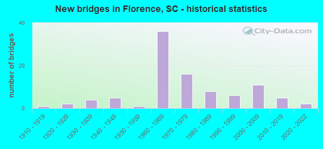
- New bridges - historical statistics
- 11910-1919
- 21920-1929
- 41930-1939
- 51940-1949
- 11950-1959
- 361960-1969
- 161970-1979
- 81980-1989
- 61990-1999
- 112000-2009
- 52010-2019
- 22020-2022

- Reconstructed bridges - Historical Statistics
- 11950-1959
- 21960-1969
- 11970-1979
- 21980-1989
- 51990-1999


- Bridge Condition - Deck
- 7.5%Excellent
- 13.4%Very good
- 28.4%Good
- 44.8%Satisfactory
- 6.0%Fair

- Bridge Condition - Superstructure
- 7.5%Excellent
- 16.4%Very good
- 28.4%Good
- 43.3%Satisfactory
- 4.5%Fair

- Bridge Condition - Substructure
- 6.0%Excellent
- 20.9%Very good
- 29.9%Good
- 37.3%Satisfactory
- 4.5%Fair
- 1.5%Poor

- Bridge Condition - Channel
- 49.0%Very good
- 29.4%Good
- 13.7%Satisfactory
- 5.9%Fair
- 2.0%Poor

- Bridge Condition - Culverts
- 10.0%Very good
- 80.0%Good
- 10.0%Satisfactory
Find on map >> Show street view
Structure Number: 104, Location: CITY OF FLORENCE (Lat: 34.173028, Lng: -79.762411), Route carried "on" structure: Ramp State highway 12, Year Built: 2019, Status: Open, Structure Length: 4.27m (14.01ft), Average Daily Traffic: 4,500 (year 2020), Truck Traffic: 6%, Average Future Daily Traffic: 2,700 (year 2040), Design Load: HL 93, Features Intersected: JEFFERIES CREEK
Minimum Vertical Clearance: 30+ m (98+ ft), Kilometerpoint: 0.399, Lanes on structure: 2, Owner: State Highway Agency, Approaching Roadway Width: 12.2m (40.0ft), Material/Design: Concrete, Design/Construction: Slab, Number Of Spans In Main Unit: 4, Length of Maximum Span: 12.2m (40.0ft), Curb-To-Curb Width: 12.2m (40.0ft), Out-to-Out Width: 13.1m (43.0ft)
Condition: Deck: Very good, Superstructure: Very good, Substructure: Very good, Channel: Very good, Operating Rating: 48.6 metric tons, Method Used To Determine Operating Rating: Load and Resistance Factor Rating (LRFR) rating reported by rating factor(RF) method using HL-93 loadings, Inventory Rating: 37.6 metric tons, Method Used To Determine Inventory Rating: Load and Resistance Factor Rating (LRFR) rating reported by rating factor(RF) method using HL-93 loadings, Structural Evaluation: Equal to present desirable criteria, Deck Geometry: Superior to present desirable criteria, Waterway Adequacy: Equal to present desirable criteria, Approach Roadway Alignment: Equal to present desirable criteria, Length Of Structure Improvement: 4.27m (14.01ft), Designated Inspection Frequency: Every 24 months, Inspection Date: April 2021, Deck Structure Type: Concrete Cast-file-Place, Wearing Surface/Protective System: Wearing Surface: Monolithic Concrete
Find on map >> Show street view
Structure Number: 10401, Location: 5 MI SE OF DARLINGTON (Lat: 34.237781, Lng: -79.837144), Route carried "on" structure: State highway 49, Year Built: 2020, Status: Open, Structure Length: 3.05m (10.01ft), Average Daily Traffic: 6,900 (year 2020), Truck Traffic: 4%, Average Future Daily Traffic: 4,140 (year 2040), Design Load: HS 20, Features Intersected: HIGH HILL CREEK
Minimum Vertical Clearance: 9.14m (29.99ft), Kilometerpoint: 4.167, Lanes on structure: 2, Owner: State Highway Agency, Approaching Roadway Width: 8.5m (27.9ft), Material/Design: Concrete, Design/Construction: Slab, Number Of Spans In Main Unit: 1, Number Of Approach Spans: 2, Length of Maximum Span: 12.2m (40.0ft), Curb-To-Curb Width: 12.2m (40.0ft), Out-to-Out Width: 13.1m (43.0ft)
Condition: Deck: Excellent, Superstructure: Excellent, Substructure: Excellent, Channel: Very good, Operating Rating: 50.2 metric tons, Method Used To Determine Operating Rating: Load and Resistance Factor Rating (LRFR) rating reported by rating factor(RF) method using HL-93 loadings, Inventory Rating: 38.6 metric tons, Method Used To Determine Inventory Rating: Load and Resistance Factor Rating (LRFR) rating reported by rating factor(RF) method using HL-93 loadings, Structural Evaluation: Superior to present desirable criteria, Deck Geometry: Somewhat better than minimum adequacy, Waterway Adequacy: Better than present minimum criteria, Approach Roadway Alignment: Equal to present minimum criteria, Bridge Posting: Required (Relationship of Operating Rating to Maximum Legal Load: > 39.9% below), Length Of Structure Improvement: 3.90m (12.80ft), Designated Inspection Frequency: Every 24 months, Inspection Date: January 2021, Bridge Improvement Cost: $394,000, Roadway Improvement Cost: $99,000, Total Project Cost: $591,000 ( Estimate for 2021), Deck Structure Type: Concrete Cast-file-Place
Find on map >> Show street view
Structure Number: 1044, Location: 7.5 MI SE OF FLORENCE (Lat: 34.102731, Lng: -79.702067), Route carried "on" structure: State highway 51, Year Built: 2019, Status: Open, Structure Length: 3.66m (12.01ft), Average Daily Traffic: 7,600 (year 2020), Truck Traffic: 10%, Average Future Daily Traffic: 5,852 (year 2040), Design Load: HL 93, Features Intersected: WILLOW CREEK
Minimum Vertical Clearance: 9.14m (29.99ft), Kilometerpoint: 49.487, Lanes on structure: 2, Base Highway Network: Yes, Owner: State Highway Agency, Approaching Roadway Width: 7.3m (24.0ft), Material/Design: Concrete, Design/Construction: Slab, Number Of Spans In Main Unit: 3, Length of Maximum Span: 12.2m (40.0ft), Curb-To-Curb Width: 25.3m (83.0ft), Out-to-Out Width: 26.2m (86.0ft)
Condition: Deck: Excellent, Superstructure: Excellent, Substructure: Excellent, Channel: Very good, Operating Rating: 51.8 metric tons, Method Used To Determine Operating Rating: Load and Resistance Factor Rating (LRFR) rating reported by rating factor(RF) method using HL-93 loadings, Inventory Rating: 39.9 metric tons, Method Used To Determine Inventory Rating: Load and Resistance Factor Rating (LRFR) rating reported by rating factor(RF) method using HL-93 loadings, Structural Evaluation: Superior to present desirable criteria, Deck Geometry: Superior to present desirable criteria, Waterway Adequacy: Equal to present minimum criteria, Approach Roadway Alignment: Equal to present minimum criteria, Length Of Structure Improvement: 3.66m (12.01ft), Designated Inspection Frequency: Every 24 months, Inspection Date: March 2020, Deck Structure Type: Concrete Cast-file-Place, Wearing Surface/Protective System: Wearing Surface: Monolithic Concrete
Find on map >> Show street view
Structure Number: 4767, Location: 7MI SW OF FLORENCE (Lat: 34.155614, Lng: -79.872564), Route carried "under" structure: US 76, Year Built: 1966, Structure Length: 0. m, Average Daily Traffic: 4,600 (year 2020), Truck Traffic: 12%, Features Intersected: US 76, Facility Carried by Structure: I-95 NB
Minimum Vertical Clearance: 4.60m (15.09ft), Kilometerpoint: 18.717, Lanes on structure: 3, Lanes under structure: 4, Material/Design: Prestressed concrete, Design/Construction: Stringer/Multi-beam, Length of Maximum Span: 18.3m (60.0ft)
Find on map >> Show street view
Structure Number: 4769, Location: 3 MI NW OF FLORENCE (Lat: 34.229703, Lng: -79.799528), Route carried "under" structure: US 52, Year Built: 1966, Structure Length: 0. m, Average Daily Traffic: 18,400 (year 2020), Truck Traffic: 10%, Features Intersected: US 52&S-21-498&RR CSXT, Facility Carried by Structure: I-95
Minimum Vertical Clearance: 6.40m (21.00ft), Kilometerpoint: 46.816, Lanes on structure: 6, Lanes under structure: 8, Material/Design: Prestressed concrete, Design/Construction: Stringer/Multi-beam, Length of Maximum Span: 17.1m (56.1ft)
Find on map >> Show street view
Structure Number: 4776, Location: 7MI SW OF FLORENCE (Lat: 34.155494, Lng: -79.872956), Route carried "under" structure: US 76, Year Built: 1966, Structure Length: 0. m, Average Daily Traffic: 4,600 (year 2020), Truck Traffic: 12%, Features Intersected: US 76, Facility Carried by Structure: I-95 SB
Minimum Vertical Clearance: 4.85m (15.91ft), Kilometerpoint: 18.717, Lanes on structure: 3, Lanes under structure: 5, Material/Design: Prestressed concrete, Design/Construction: Stringer/Multi-beam, Length of Maximum Span: 18.3m (60.0ft)
Find on map >> Show street view
Structure Number: 4778, Location: 4.0 MI NW OF FLORENCE (Lat: 34.204842, Lng: -79.833358), Route carried "under" structure: State highway 13, Year Built: 1966, Structure Length: 0. m, Average Daily Traffic: 8,200 (year 2020), Truck Traffic: 2%, Features Intersected: S-21-13, Facility Carried by Structure: I-95 SB
Minimum Vertical Clearance: 4.75m (15.58ft), Kilometerpoint: 3.460, Lanes on structure: 3, Lanes under structure: 4, Material/Design: Prestressed concrete, Design/Construction: Stringer/Multi-beam, Length of Maximum Span: 21.3m (69.9ft)
Find on map >> Show street view
Structure Number: 4786, Location: 3 MI NW FLORENCE (Lat: 34.238956, Lng: -79.788211), Route carried "under" structure: Interstate 95, Year Built: 1966, Structure Length: 0. m, Average Daily Traffic: 48,500 (year 2020), Truck Traffic: 19%, Features Intersected: I-95, Facility Carried by Structure: S-21-63
Minimum Vertical Clearance: 5.82m (19.09ft), Kilometerpoint: 265.558, Lanes on structure: 2, Lanes under structure: 6, Material/Design: Prestressed concrete, Design/Construction: Stringer/Multi-beam, Length of Maximum Span: 23.8m (78.1ft)
Find on map >> Show street view
Structure Number: 4787, Location: 4MI SW FLORENCE (Lat: 34.146633, Lng: -79.876161), Route carried "under" structure: Interstate 95, Year Built: 1966, Structure Length: 0. m, Average Daily Traffic: 31,000 (year 2020), Truck Traffic: 20%, Features Intersected: I-95, Facility Carried by Structure: S-21-107
Minimum Vertical Clearance: 5.23m (17.16ft), Kilometerpoint: 252.039, Lanes on structure: 2, Lanes under structure: 4, Material/Design: Prestressed concrete, Design/Construction: Stringer/Multi-beam, Length of Maximum Span: 19.8m (65.0ft)
Find on map >> Show street view
Structure Number: 4789, Location: OAKDALE SUBD FLORENCE (Lat: 34.178064, Lng: -79.863894), Route carried "under" structure: Interstate 95, Year Built: 2012, Structure Length: 0. m, Average Daily Traffic: 30,200 (year 2020), Truck Traffic: 9%, Features Intersected: I-95, Facility Carried by Structure: S-21-577
Minimum Vertical Clearance: 6.38m (20.93ft), Kilometerpoint: 255.725, Lanes on structure: 5, Lanes under structure: 4, Material/Design: Prestressed concrete continuous, Design/Construction: Stringer/Multi-beam, Length of Maximum Span: 29.3m (96.1ft)
Find on map >> Show street view
Structure Number: 5013, Location: 5MI N FLORENCE (Lat: 34.250111, Lng: -79.762697), Route carried "under" structure: Interstate 95, Year Built: 1967, Structure Length: 0. m, Average Daily Traffic: 48,500 (year 2020), Truck Traffic: 19%, Features Intersected: I-95, Facility Carried by Structure: S-16-179
Minimum Vertical Clearance: 5.82m (19.09ft), Kilometerpoint: 268.262, Lanes on structure: 2, Lanes under structure: 6, Material/Design: Steel, Design/Construction: Stringer/Multi-beam, Length of Maximum Span: 26.8m (87.9ft)
Find on map >> Show street view
Structure Number: 5038, Location: 4.7 MI W OF FLORENCE (Lat: 34.193347, Lng: -79.844283), Route carried "under" structure: Interstate 95, Year Built: 1967, Structure Length: 0. m, Average Daily Traffic: 15,100 (year 2020), Truck Traffic: 9%, Features Intersected: I-95, Facility Carried by Structure: I-20 EB
Minimum Vertical Clearance: 5.08m (16.67ft), Kilometerpoint: 258.251, Lanes on structure: 3, Lanes under structure: 6, Material/Design: Steel, Design/Construction: Stringer/Multi-beam, Length of Maximum Span: 26.2m (86.0ft)
Find on map >> Show street view
Structure Number: 5039, Location: 4.7 MI W OF FLORENCE (Lat: 34.193550, Lng: -79.843922), Route carried "under" structure: Interstate 95, Year Built: 1967, Structure Length: 0. m, Average Daily Traffic: 15,100 (year 2020), Truck Traffic: 9%, Features Intersected: I-95, Facility Carried by Structure: I-20 WB
Minimum Vertical Clearance: 5.11m (16.77ft), Kilometerpoint: 258.251, Lanes on structure: 3, Lanes under structure: 6, Material/Design: Steel, Design/Construction: Stringer/Multi-beam, Length of Maximum Span: 26.2m (86.0ft)
Find on map >> Show street view
Structure Number: 5044, Location: 4 MI NW OF FLORENCE (Lat: 34.204725, Lng: -79.833033), Route carried "under" structure: State highway 13, Year Built: 1967, Structure Length: 0. m, Average Daily Traffic: 8,200 (year 2020), Truck Traffic: 2%, Features Intersected: S-21-13, Facility Carried by Structure: I-95 NB
Minimum Vertical Clearance: 4.75m (15.58ft), Kilometerpoint: 3.460, Lanes on structure: 3, Lanes under structure: 4, Material/Design: Prestressed concrete, Design/Construction: Stringer/Multi-beam, Length of Maximum Span: 21.3m (69.9ft)
Find on map >> Show street view
Structure Number: 505, Location: 4.5 MI W OF FLORENCE (Lat: 34.196056, Lng: -79.840611), Route carried "under" structure: Ramp Interstate 20, Year Built: 1967, Structure Length: 0. m, Average Daily Traffic: 8,760 (year 2004), Truck Traffic: 18%, Features Intersected: I-20 EB, Facility Carried by Structure: I-95 SB
Minimum Vertical Clearance: 5.21m (17.09ft), Kilometerpoint: 227.674, Lanes on structure: 2, Lanes under structure: 2, Material/Design: Steel, Design/Construction: Stringer/Multi-beam, Length of Maximum Span: 29.0m (95.1ft)
Find on map >> Show street view
Structure Number: 5056, Location: 2MI W FLORENCE (Lat: 34.196494, Lng: -79.849492), Route carried "under" structure: Interstate 20, Year Built: 1967, Structure Length: 0. m, Average Daily Traffic: 28,000 (year 2020), Truck Traffic: 11%, Features Intersected: I-20, Facility Carried by Structure: S-21-112
Minimum Vertical Clearance: 5.84m (19.16ft), Kilometerpoint: 227.095, Lanes on structure: 2, Lanes under structure: 8, Material/Design: Steel, Design/Construction: Stringer/Multi-beam, Length of Maximum Span: 25.0m (82.0ft)
Find on map >> Show street view
Structure Number: 5057, Location: 2MI W FLORENCE (Lat: 34.190561, Lng: -79.848250), Route carried "under" structure: Interstate 95, Year Built: 1967, Structure Length: 0. m, Average Daily Traffic: 30,200 (year 2020), Truck Traffic: 9%, Features Intersected: I-95, Facility Carried by Structure: S-21-112
Minimum Vertical Clearance: 5.46m (17.91ft), Kilometerpoint: 257.736, Lanes on structure: 2, Lanes under structure: 5, Material/Design: Steel, Design/Construction: Stringer/Multi-beam, Length of Maximum Span: 26.5m (86.9ft)
Find on map >> Show street view
Structure Number: 5058, Location: 3MI NW FLORENCE (Lat: 34.217208, Lng: -79.816942), Route carried "under" structure: Interstate 95, Year Built: 1967, Structure Length: 0. m, Average Daily Traffic: 51,700 (year 2020), Truck Traffic: 9%, Features Intersected: I-95, Facility Carried by Structure: S-21-193
Minimum Vertical Clearance: 5.23m (17.16ft), Kilometerpoint: 261.953, Lanes on structure: 2, Lanes under structure: 6, Material/Design: Prestressed concrete, Design/Construction: Stringer/Multi-beam, Length of Maximum Span: 17.4m (57.1ft)
Find on map >> Show street view
Structure Number: 6261, Location: 7MI S OF DARLINGTON (Lat: 34.204017, Lng: -79.913347), Route carried "under" structure: State highway 340, Year Built: 1973, Structure Length: 0. m, Average Daily Traffic: 975 (year 2020), Truck Traffic: 5%, Features Intersected: SC 340, Facility Carried by Structure: I-20 EB
Minimum Vertical Clearance: 5.18m (16.99ft), Kilometerpoint: 6.341, Lanes on structure: 2, Lanes under structure: 3, Material/Design: Steel, Design/Construction: Stringer/Multi-beam, Length of Maximum Span: 38.4m (126.0ft)
Find on map >> Show street view
Structure Number: 6264, Location: 9MI W OF FLORENCE (Lat: 34.204211, Lng: -79.913094), Route carried "under" structure: State highway 340, Year Built: 1973, Structure Length: 0. m, Average Daily Traffic: 975 (year 2020), Truck Traffic: 5%, Features Intersected: SC 340, Facility Carried by Structure: I-20 WB
Minimum Vertical Clearance: 5.18m (16.99ft), Kilometerpoint: 6.341, Lanes on structure: 2, Lanes under structure: 3, Material/Design: Steel, Design/Construction: Stringer/Multi-beam, Length of Maximum Span: 38.4m (126.0ft)
Find on map >> Show street view
Structure Number: 6291, Location: 4.8 MI W FLORENCE (Lat: 34.195386, Lng: -79.846131), Route carried "under" structure: Interstate 20, Year Built: 1973, Structure Length: 0. m, Average Daily Traffic: 28,000 (year 2020), Truck Traffic: 11%, Features Intersected: RAMP ON I-20 WB
Minimum Vertical Clearance: 5.18m (16.99ft), Kilometerpoint: 227.400, Lanes on structure: 1, Lanes under structure: 2, Material/Design: Steel continuous, Design/Construction: Stringer/Multi-beam, Length of Maximum Span: 32.0m (105.0ft)
Find on map >> Show street view
Structure Number: 6493, Location: 1MI W I-95 & I-20 INT (Lat: 34.204311, Lng: -79.879228), Route carried "under" structure: Interstate 20, Year Built: 1974, Structure Length: 0. m, Average Daily Traffic: 28,000 (year 2020), Truck Traffic: 11%, Features Intersected: I-20, Facility Carried by Structure: S-21-1355
Minimum Vertical Clearance: 5.41m (17.75ft), Kilometerpoint: 224.182, Lanes on structure: 2, Lanes under structure: 4, Material/Design: Steel, Design/Construction: Stringer/Multi-beam, Length of Maximum Span: 29.6m (97.1ft)
Find on map >> Show street view
Structure Number: 7357, Location: CHURCH ST FLORENCE (Lat: 34.197261, Lng: -79.761997), Route carried "under" structure: State highway 1545, Year Built: 1980, Structure Length: 0. m, Average Daily Traffic: 125 (year 2020), Truck Traffic: 5%, Features Intersected: S-1545, Facility Carried by Structure: S-21-12
Minimum Vertical Clearance: 4.27m (14.01ft), Kilometerpoint: 0.446, Lanes on structure: 4, Lanes under structure: 4, Material/Design: Concrete, Design/Construction: Slab, Length of Maximum Span: 9.1m (29.9ft)