Bridge Statistics for Fairmont, West Virginia (WV)
Condition, Traffic, Stress, Structural Evaluation, Project Costs
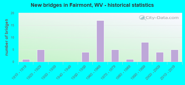
- New bridges - historical statistics
- 11910-1919
- 51920-1929
- 41950-1959
- 171960-1969
- 51970-1979
- 11980-1989
- 81990-1999
- 42000-2009
- 52010-2019
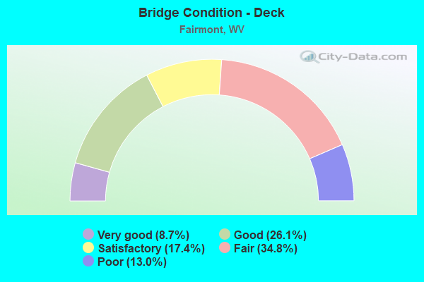
- Bridge Condition - Deck
- 8.7%Very good
- 26.1%Good
- 17.4%Satisfactory
- 34.8%Fair
- 13.0%Poor
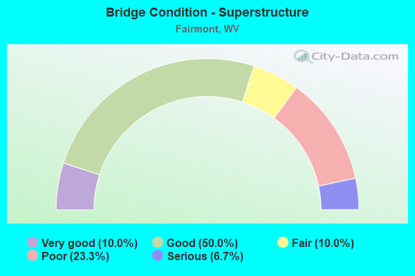
- Bridge Condition - Superstructure
- 10.0%Very good
- 50.0%Good
- 10.0%Fair
- 23.3%Poor
- 6.7%Serious
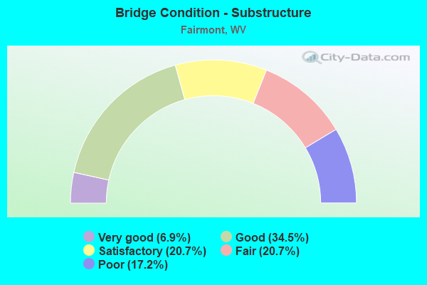
- Bridge Condition - Substructure
- 6.9%Very good
- 34.5%Good
- 20.7%Satisfactory
- 20.7%Fair
- 17.2%Poor
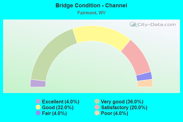
- Bridge Condition - Channel
- 4.0%Excellent
- 36.0%Very good
- 32.0%Good
- 20.0%Satisfactory
- 4.0%Fair
- 4.0%Poor
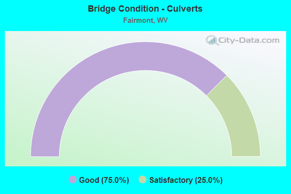
- Bridge Condition - Culverts
- 75.0%Good
- 25.0%Satisfactory
Find on map >> Show street view
Structure Number: 25A077, Location: 0.29 MI WEST CO RT 76/1 (Lat: 39.481619, Lng: -80.072739), Route carried "on" structure: County highway 3302, Year Built: 1990, Status: Open, Structure Length: 1.20m (3.94ft), Average Daily Traffic: 200 (year 2018), Truck Traffic: 9%, Average Future Daily Traffic: 250 (year 2038), Design Load: HS 25 or greater, Features Intersected: REUBEN RUN, Facility Carried by Structure: MARION CO RT 33/2
Minimum Vertical Clearance: 30+ m (98+ ft), Kilometerpoint: 0.885, Lanes on structure: 2, Owner: State Highway Agency, Approaching Roadway Width: 4.0m (13.1ft), Skew: 6 degrees, Material/Design: Prestressed concrete, Design/Construction: Box Beam or Girders - Multiple, Number Of Spans In Main Unit: 1, Length of Maximum Span: 11.6m (38.1ft), Curb-To-Curb Width: 5.5m (18.0ft), Out-to-Out Width: 5.5m (18.0ft)
Condition: Superstructure: Good, Substructure: Satisfactory, Channel: Good, Operating Rating: 88.9 metric tons, Method Used To Determine Operating Rating: Load Factor (LF), Inventory Rating: 59.0 metric tons, Method Used To Determine Inventory Rating: Load Factor (LF), Structural Evaluation: Equal to present minimum criteria, Deck Geometry: High priority of corrective action, Waterway Adequacy: Somewhat better than minimum adequacy, Approach Roadway Alignment: Equal to present minimum criteria, Length Of Structure Improvement: 1.89m (6.20ft), Designated Inspection Frequency: Every 24 months, Inspection Date: September 2020, Bridge Improvement Cost: $251,000, Roadway Improvement Cost: $222,000, Total Project Cost: $493,000 ( Estimate for 2020), Deck Structure Type: Other, Wearing Surface/Protective System: Wearing Surface: Bituminous, Deck Protection: Epoxy Coated Reinforcing
Find on map >> Show street view
Structure Number: 25A1, Location: 0.01 MI WEST MARION CR 58 (Lat: 39.456861, Lng: -80.203161), Route carried "on" structure: County highway 5600, Year Built: 1971, Status: Posted for load, Structure Length: 3.10m (10.17ft), Average Daily Traffic: 2,600 (year 2019), Truck Traffic: 8%, Average Future Daily Traffic: 4,000 (year 2041), Design Load: HS 20, Features Intersected: BOOTHS CREEK, Facility Carried by Structure: MARION CO RT 56
Minimum Vertical Clearance: 30+ m (98+ ft), Kilometerpoint: 1.963, Lanes on structure: 2, Owner: State Highway Agency, Approaching Roadway Width: 5.5m (18.0ft), Material/Design: Concrete, Design/Construction: Channel Beam, Number Of Spans In Main Unit: 1, Number Of Approach Spans: 1, Length of Maximum Span: 13.8m (45.3ft), Curb-To-Curb Width: 7.6m (24.9ft), Out-to-Out Width: 8.4m (27.6ft)
Condition: Deck: Poor, Superstructure: Serious, Substructure: Satisfactory, Channel: Good, Operating Rating: 32.7 metric tons, Method Used To Determine Operating Rating: Field evaluation and documented engineering judgment, Inventory Rating: 16.3 metric tons, Method Used To Determine Inventory Rating: Field evaluation and documented engineering judgment, Structural Evaluation: High priority of corrective action, Deck Geometry: High priority of replacement, Waterway Adequacy: Equal to present desirable criteria, Approach Roadway Alignment: Meets minimum limits, Bridge Posting: Required (Relationship of Operating Rating to Maximum Legal Load: 10.0 - 19.9% below), Length Of Structure Improvement: 3.99m (13.09ft), Designated Inspection Frequency: Every 24 months, Other Special Inspection Frequency: Every 6 months, Inspection Date: March 2020, Other Special Inspection Date: March 2021, Bridge Improvement Cost: $453,000, Roadway Improvement Cost: $399,000, Total Project Cost: $1,084,000 ( Estimate for 2021), Deck Structure Type: Concrete Cast-file-Place, Wearing Surface/Protective System: Wearing Surface: Bituminous
Find on map >> Show street view
Structure Number: 25A101, Location: 0.16 MI NORTH CO RT 58/4 (Lat: 39.434131, Lng: -80.203681), Route carried "on" structure: County highway 5800, Year Built: 1993, Status: Open, Structure Length: 2.00m (6.56ft), Average Daily Traffic: 7,100 (year 2019), Truck Traffic: 8%, Average Future Daily Traffic: 11,075 (year 2041), Design Load: HS 25 or greater, Features Intersected: BOOTHS CREEK, Facility Carried by Structure: MARION COUNTY 58
Minimum Vertical Clearance: 30+ m (98+ ft), Kilometerpoint: 1.658, Lanes on structure: 2, Owner: State Highway Agency, Approaching Roadway Width: 7.9m (25.9ft), Skew: 3 degrees, Material/Design: Prestressed concrete, Design/Construction: Box Beam or Girders - Multiple, Number Of Spans In Main Unit: 1, Length of Maximum Span: 19.5m (64.0ft), Curb-To-Curb Width: 8.0m (26.2ft), Out-to-Out Width: 8.4m (27.6ft)
Condition: Deck: Good, Superstructure: Good, Substructure: Good, Channel: Very good, Operating Rating: 88.9 metric tons, Method Used To Determine Operating Rating: Load Factor (LF), Inventory Rating: 68.0 metric tons, Method Used To Determine Inventory Rating: Load Factor (LF), Structural Evaluation: Better than present minimum criteria, Deck Geometry: High priority of replacement, Waterway Adequacy: Equal to present desirable criteria, Approach Roadway Alignment: Somewhat better than minimum adequacy, Length Of Structure Improvement: 2.01m (6.59ft), Designated Inspection Frequency: Every 24 months, Inspection Date: September 2021, Bridge Improvement Cost: $211,000, Roadway Improvement Cost: $154,000, Total Project Cost: $368,000 ( Estimate for 2021), Deck Structure Type: Other, Wearing Surface/Protective System: Wearing Surface: Bituminous, Deck Protection: Epoxy Coated Reinforcing
Find on map >> Show street view
Structure Number: 25A103, Location: 0.17 MI NORTH CO RT 58/1 (Lat: 39.440461, Lng: -80.210489), Route carried "on" structure: County highway 5800, Year Built: 1977, Status: Open, Structure Length: 4.61m (15.12ft), Average Daily Traffic: 1,300 (year 2019), Truck Traffic: 8%, Average Future Daily Traffic: 2,000 (year 2041), Design Load: HS 20, Features Intersected: BOOTHS CREEK, Facility Carried by Structure: MARION CO. RT. 58
Minimum Vertical Clearance: 30+ m (98+ ft), Kilometerpoint: 2.607, Lanes on structure: 2, Owner: State Highway Agency, Approaching Roadway Width: 7.3m (24.0ft), Skew: 4 degrees, Material/Design: Steel continuous, Design/Construction: Stringer/Multi-beam, Number Of Spans In Main Unit: 2, Length of Maximum Span: 22.2m (72.8ft), Curb-To-Curb Width: 7.3m (24.0ft), Out-to-Out Width: 8.5m (27.9ft)
Condition: Deck: Good, Superstructure: Good, Substructure: Good, Channel: Satisfactory, Operating Rating: 59.9 metric tons, Method Used To Determine Operating Rating: Load Factor (LF), Inventory Rating: 36.3 metric tons, Method Used To Determine Inventory Rating: Load Factor (LF), Structural Evaluation: Better than present minimum criteria, Deck Geometry: Meets minimum limits, Waterway Adequacy: Equal to present minimum criteria, Approach Roadway Alignment: Meets minimum limits, Designated Inspection Frequency: Every 48 months, Inspection Date: December 2020, Deck Structure Type: Concrete Cast-file-Place, Wearing Surface/Protective System: Deck Protection: Epoxy Coated Reinforcing
Find on map >> Show street view
Structure Number: 25A105, Location: 0.31 MI NORTH CO RT 58 (Lat: 39.426750, Lng: -80.209369), Route carried "on" structure: County highway 5802, Year Built: 1990, Status: Open, Structure Length: 2.07m (6.79ft), Average Daily Traffic: 100 (year 2019), Average Future Daily Traffic: 155 (year 2041), Design Load: HS 25 or greater, Features Intersected: BOOTHS CREEK, Facility Carried by Structure: MARION CO RT 58/2
Minimum Vertical Clearance: 30+ m (98+ ft), Kilometerpoint: 0.499, Lanes on structure: 1, Owner: State Highway Agency, Approaching Roadway Width: 5.8m (19.0ft), Skew: 2 degrees, Material/Design: Prestressed concrete, Design/Construction: Box Beam or Girders - Multiple, Number Of Spans In Main Unit: 1, Length of Maximum Span: 19.5m (64.0ft), Curb-To-Curb Width: 4.6m (15.1ft), Out-to-Out Width: 4.6m (15.1ft)
Condition: Superstructure: Good, Substructure: Good, Channel: Very good, Operating Rating: 88.9 metric tons, Method Used To Determine Operating Rating: Load Factor (LF), Inventory Rating: 60.8 metric tons, Method Used To Determine Inventory Rating: Load Factor (LF), Structural Evaluation: Better than present minimum criteria, Deck Geometry: Better than present minimum criteria, Waterway Adequacy: Better than present minimum criteria, Approach Roadway Alignment: Equal to present minimum criteria, Designated Inspection Frequency: Every 48 months, Inspection Date: April 2021, Deck Structure Type: Other, Wearing Surface/Protective System: Wearing Surface: Bituminous, Deck Protection: Epoxy Coated Reinforcing
Find on map >> Show street view
Structure Number: 25A108, Location: 0.03 MI SOUTH CO RT 33 (Lat: 39.487739, Lng: -80.090811), Route carried "on" structure: County highway 6800, Year Built: 1969, Status: Open, Structure Length: 1.04m (3.41ft), Average Daily Traffic: 100 (year 2018), Average Future Daily Traffic: 125 (year 2038), Design Load: HS 20, Features Intersected: PRICKETT CREEK, Facility Carried by Structure: MARION CO RT 68
Minimum Vertical Clearance: 30+ m (98+ ft), Kilometerpoint: 4.715, Lanes on structure: 2, Owner: State Highway Agency, Approaching Roadway Width: 7.6m (24.9ft), Skew: 2 degrees, Material/Design: Concrete continuous, Design/Construction: Culvert, Number Of Spans In Main Unit: 3, Length of Maximum Span: 3.2m (10.5ft)
Condition: Channel: Poor, Culverts: Good, Operating Rating: 71.7 metric tons, Method Used To Determine Operating Rating: Field evaluation and documented engineering judgment, Inventory Rating: 32.7 metric tons, Method Used To Determine Inventory Rating: Field evaluation and documented engineering judgment, Structural Evaluation: Better than present minimum criteria, Waterway Adequacy: Superior to present desirable criteria, Approach Roadway Alignment: Equal to present desirable criteria, Designated Inspection Frequency: Every 24 months, Inspection Date: November 2020
Find on map >> Show street view
Structure Number: 25A111, Location: 0.05 MI WEST CO RT 33 (Lat: 39.472011, Lng: -80.080731), Route carried "on" structure: County highway 6801, Year Built: 1917, Status: Posted for load, Structure Length: 1.83m (6.00ft), Average Daily Traffic: 50 (year 2018), Average Future Daily Traffic: 60 (year 2038), Features Intersected: PRICKETT CREEK, Facility Carried by Structure: MARION CO RT 68/1
Minimum Vertical Clearance: 30+ m (98+ ft), Kilometerpoint: 1.416, Lanes on structure: 1, Owner: State Highway Agency, Approaching Roadway Width: 4.3m (14.1ft), Material/Design: Concrete, Design/Construction: Arch - Deck, Number Of Spans In Main Unit: 1, Length of Maximum Span: 18.3m (60.0ft), Curb or Sidewalk Widths: Left: 0.1m (0.3ft), Right: 0.1m (0.3ft), Curb-To-Curb Width: 3.9m (12.8ft), Out-to-Out Width: 4.8m (15.7ft)
Condition: Superstructure: Poor, Channel: Very good, Operating Rating: 25.4 metric tons, Method Used To Determine Operating Rating: Field evaluation and documented engineering judgment, Inventory Rating: 10.9 metric tons, Method Used To Determine Inventory Rating: Field evaluation and documented engineering judgment, Structural Evaluation: Meets minimum limits, Deck Geometry: Meets minimum limits, Waterway Adequacy: Equal to present desirable criteria, Approach Roadway Alignment: Equal to present minimum criteria, Length Of Structure Improvement: 2.65m (8.69ft), Designated Inspection Frequency: Every 24 months, Inspection Date: September 2020, Bridge Improvement Cost: $269,000, Roadway Improvement Cost: $204,000, Total Project Cost: $551,000 ( Estimate for 2020)
Find on map >> Show street view
Structure Number: 25A118, Location: 0.02 MI NORTH CO RT 73/19 (Lat: 39.495319, Lng: -80.093569), Route carried "on" structure: County highway 7306, Year Built: 1923, Status: Open, Structure Length: 1.83m (6.00ft), Average Daily Traffic: 800 (year 2019), Truck Traffic: 8%, Average Future Daily Traffic: 1,250 (year 2041), Features Intersected: PRICKETT CREEK, Facility Carried by Structure: MARION CO 73/6
Minimum Vertical Clearance: 30+ m (98+ ft), Kilometerpoint: 1.030, Lanes on structure: 2, Owner: State Highway Agency, Approaching Roadway Width: 6.1m (20.0ft), Material/Design: Concrete, Design/Construction: Arch - Deck, Number Of Spans In Main Unit: 1, Length of Maximum Span: 18.3m (60.0ft), Curb-To-Curb Width: 5.6m (18.4ft), Out-to-Out Width: 6.3m (20.7ft)
Condition: Superstructure: Poor, Substructure: Poor, Channel: Very good, Operating Rating: 41.7 metric tons, Method Used To Determine Operating Rating: Field evaluation and documented engineering judgment, Inventory Rating: 16.3 metric tons, Method Used To Determine Inventory Rating: Field evaluation and documented engineering judgment, Structural Evaluation: Meets minimum limits, Deck Geometry: High priority of replacement, Waterway Adequacy: Better than present minimum criteria, Approach Roadway Alignment: Better than present minimum criteria, Length Of Structure Improvement: 2.93m (9.61ft), Designated Inspection Frequency: Every 24 months, Inspection Date: Febuary 2021, Bridge Improvement Cost: $283,000, Roadway Improvement Cost: $231,000, Total Project Cost: $618,000 ( Estimate for 2021)
Find on map >> Show street view
Structure Number: 25A12, Location: 0.20 MI NORTH CO RT 58 (Lat: 39.422761, Lng: -80.198089), Route carried "on" structure: County highway 7373, Year Built: 1966, Status: Open, Structure Length: 8.60m (28.22ft), Average Daily Traffic: 10,300 (year 2019), Truck Traffic: 8%, Average Future Daily Traffic: 16,070 (year 2041), Design Load: HS 20, Features Intersected: I-79 NB & SB, Facility Carried by Structure: MARION CO RT 73/73
Minimum Vertical Clearance: 30+ m (98+ ft), Kilometerpoint: 4.216, Lanes on structure: 2, Lanes under structure: 4, Owner: State Highway Agency, Approaching Roadway Width: 8.5m (27.9ft), Skew: 4 degrees, Material/Design: Steel continuous, Design/Construction: Stringer/Multi-beam, Number Of Spans In Main Unit: 2, Number Of Approach Spans: 2, Length of Maximum Span: 24.8m (81.4ft), Curb-To-Curb Width: 8.5m (27.9ft), Out-to-Out Width: 10.1m (33.1ft)
Condition: Deck: Satisfactory, Superstructure: Good, Substructure: Satisfactory, Operating Rating: 70.7 metric tons, Method Used To Determine Operating Rating: Load Factor (LF), Inventory Rating: 42.6 metric tons, Method Used To Determine Inventory Rating: Load Factor (LF), Structural Evaluation: Equal to present minimum criteria, Deck Geometry: Meets minimum limits, Underclear: Somewhat better than minimum adequacy, Approach Roadway Alignment: Somewhat better than minimum adequacy, Designated Inspection Frequency: Every 24 months, Inspection Date: August 2021, Deck Structure Type: Concrete Cast-file-Place, Wearing Surface/Protective System: Wearing Surface: Latex Concrete
Find on map >> Show street view
Structure Number: 25A121, Location: 0.09 MI NORTH CO RT 73/6 (Lat: 39.513989, Lng: -80.068081), Route carried "on" structure: County highway 7400, Year Built: 1995, Status: Open, Structure Length: 1.38m (4.53ft), Average Daily Traffic: 500 (year 2018), Truck Traffic: 9%, Average Future Daily Traffic: 625 (year 2038), Design Load: HS 25 or greater, Features Intersected: LITTLE CREEK, Facility Carried by Structure: MARION CO RT 74
Minimum Vertical Clearance: 30+ m (98+ ft), Kilometerpoint: 0.145, Lanes on structure: 2, Owner: State Highway Agency, Approaching Roadway Width: 7.3m (24.0ft), Skew: 5 degrees, Material/Design: Concrete continuous, Design/Construction: Culvert, Number Of Spans In Main Unit: 3, Length of Maximum Span: 4.2m (13.8ft)
Condition: Channel: Satisfactory, Culverts: Good, Operating Rating: 88.9 metric tons, Method Used To Determine Operating Rating: Field evaluation and documented engineering judgment, Inventory Rating: 40.8 metric tons, Method Used To Determine Inventory Rating: Field evaluation and documented engineering judgment, Structural Evaluation: Better than present minimum criteria, Waterway Adequacy: Equal to present minimum criteria, Approach Roadway Alignment: Better than present minimum criteria, Designated Inspection Frequency: Every 48 months, Inspection Date: December 2019
Find on map >> Show street view
Structure Number: 25A127, Location: 0.15 MI SOUTH CO RT 73/6 (Lat: 39.501681, Lng: -80.066889), Route carried "on" structure: County highway 7600, Year Built: 1950, Status: Posted for load, Structure Length: 1.30m (4.27ft), Average Daily Traffic: 350 (year 2019), Average Future Daily Traffic: 550 (year 2041), Features Intersected: LITTLE CREEK, Facility Carried by Structure: MARION CO RT 76
Minimum Vertical Clearance: 30+ m (98+ ft), Kilometerpoint: 5.745, Lanes on structure: 1, Owner: State Highway Agency, Approaching Roadway Width: 3.0m (9.8ft), Material/Design: Steel, Design/Construction: Girder and Floorbeam System, Number Of Spans In Main Unit: 1, Length of Maximum Span: 12.2m (40.0ft), Curb-To-Curb Width: 4.1m (13.5ft), Out-to-Out Width: 4.1m (13.5ft)
Condition: Deck: Fair, Superstructure: Serious, Substructure: Fair, Channel: Good, Operating Rating: 11.8 metric tons, Method Used To Determine Operating Rating: Load Factor (LF), Inventory Rating: 7.3 metric tons, Method Used To Determine Inventory Rating: Load Factor (LF), Structural Evaluation: High priority of replacement, Deck Geometry: High priority of replacement, Waterway Adequacy: Equal to present minimum criteria, Approach Roadway Alignment: Meets minimum limits, Bridge Posting: Required (Relationship of Operating Rating to Maximum Legal Load: > 39.9% below), Length Of Structure Improvement: 1.98m (6.50ft), Designated Inspection Frequency: Every 24 months, Critical Feature Inspection Frequency: Every 24 months, Inspection Date: May 2021, Critical Feature Inspection Date: May 2021, Bridge Improvement Cost: $244,000, Roadway Improvement Cost: $181,000, Total Project Cost: $499,000 ( Estimate for 2021), Deck Structure Type: Wood or Timber
Find on map >> Show street view
Structure Number: 25A134, Location: 0.12 MI SOUTH CR 72 (Lat: 39.496789, Lng: -80.094669), Route carried "on" structure: County highway 7300, Year Built: 1955, Status: Posted for load, Structure Length: 3.68m (12.07ft), Average Daily Traffic: 6,700 (year 2018), Truck Traffic: 9%, Average Future Daily Traffic: 8,250 (year 2038), Design Load: H 15, Features Intersected: PRICKETT CREEK, Facility Carried by Structure: COUNTY ROUTE 73
Minimum Vertical Clearance: 30+ m (98+ ft), Kilometerpoint: 3.605, Lanes on structure: 2, Owner: State Highway Agency, Approaching Roadway Width: 9.1m (29.9ft), Skew: 2 degrees, Material/Design: Steel continuous, Design/Construction: Stringer/Multi-beam, Number Of Spans In Main Unit: 1, Number Of Approach Spans: 2, Length of Maximum Span: 13.7m (44.9ft), Curb or Sidewalk Widths: Left: 0.9m (3.0ft), Right: 0.9m (3.0ft), Curb-To-Curb Width: 8.0m (26.2ft), Out-to-Out Width: 10.4m (34.1ft)
Condition: Deck: Poor, Superstructure: Poor, Substructure: Fair, Channel: Good, Operating Rating: 38.1 metric tons, Method Used To Determine Operating Rating: Load Factor (LF), Inventory Rating: 22.7 metric tons, Method Used To Determine Inventory Rating: Load Factor (LF), Structural Evaluation: Meets minimum limits, Deck Geometry: High priority of replacement, Waterway Adequacy: Equal to present desirable criteria, Approach Roadway Alignment: Better than present minimum criteria, Length Of Structure Improvement: 3.69m (12.11ft), Designated Inspection Frequency: Every 24 months, Inspection Date: September 2020, Bridge Improvement Cost: $601,000, Roadway Improvement Cost: $142,000, Total Project Cost: $788,000 ( Estimate for 2021), Deck Structure Type: Concrete Cast-file-Place, Wearing Surface/Protective System: Wearing Surface: Bituminous
Find on map >> Show street view
Structure Number: 25A142, Location: 1.70 MI NORTH CO RT 64/2 (Lat: 39.472089, Lng: -80.120689), Route carried "on" structure: Interstate 7900, Year Built: 1966, Status: Open, Structure Length: 4.79m (15.72ft), Average Daily Traffic: 23,000 (year 2019), Truck Traffic: 14%, Average Future Daily Traffic: 31,280 (year 2041), Design Load: HS 20, Features Intersected: WV 310, Facility Carried by Structure: INTERSTATE 79 NB
Minimum Vertical Clearance: 30+ m (98+ ft), Kilometerpoint: 219.901, Lanes on structure: 3, Lanes under structure: 4, Base Highway Network: Yes, Owner: State Highway Agency, Approaching Roadway Width: 15.9m (52.2ft), Material/Design: Steel continuous, Design/Construction: Stringer/Multi-beam, Number Of Spans In Main Unit: 2, Length of Maximum Span: 23.3m (76.4ft), Curb-To-Curb Width: 12.8m (42.0ft), Out-to-Out Width: 14.3m (46.9ft)
Condition: Deck: Fair, Superstructure: Good, Substructure: Satisfactory, Operating Rating: 68.0 metric tons, Method Used To Determine Operating Rating: Load Factor (LF), Inventory Rating: 40.8 metric tons, Method Used To Determine Inventory Rating: Load Factor (LF), Structural Evaluation: Equal to present minimum criteria, Deck Geometry: High priority of replacement, Underclear: Meets minimum limits, Approach Roadway Alignment: Equal to present desirable criteria, Length Of Structure Improvement: 4.79m (15.72ft), Designated Inspection Frequency: Every 24 months, Inspection Date: August 2021, Bridge Improvement Cost: $583,000, Roadway Improvement Cost: $121,000, Total Project Cost: $968,000 ( Estimate for 2021), Deck Structure Type: Concrete Cast-file-Place, Wearing Surface/Protective System: Wearing Surface: Latex Concrete
Find on map >> Show street view
Structure Number: 25A143, Location: 1.70 MI NORTH CO RT 64/2 (Lat: 39.472269, Lng: -80.120819), Route carried "on" structure: Interstate 7900, Year Built: 1966, Status: Open, Structure Length: 4.79m (15.72ft), Average Daily Traffic: 23,000 (year 2019), Truck Traffic: 14%, Average Future Daily Traffic: 31,280 (year 2041), Design Load: HS 20, Features Intersected: WV 310, Facility Carried by Structure: INTERSTATE 79 SB
Minimum Vertical Clearance: 30+ m (98+ ft), Kilometerpoint: 219.901, Lanes on structure: 2, Lanes under structure: 4, Base Highway Network: Yes, Owner: State Highway Agency, Approaching Roadway Width: 11.3m (37.1ft), Material/Design: Steel continuous, Design/Construction: Stringer/Multi-beam, Number Of Spans In Main Unit: 2, Length of Maximum Span: 23.3m (76.4ft), Curb-To-Curb Width: 11.3m (37.1ft), Out-to-Out Width: 12.3m (40.4ft)
Condition: Deck: Fair, Superstructure: Poor, Substructure: Fair, Operating Rating: 65.3 metric tons, Method Used To Determine Operating Rating: Load Factor (LF), Inventory Rating: 39.0 metric tons, Method Used To Determine Inventory Rating: Load Factor (LF), Structural Evaluation: Meets minimum limits, Deck Geometry: Somewhat better than minimum adequacy, Underclear: Meets minimum limits, Approach Roadway Alignment: Better than present minimum criteria, Length Of Structure Improvement: 4.79m (15.72ft), Designated Inspection Frequency: Every 24 months, Other Special Inspection Frequency: Every 12 months, Inspection Date: August 2021, Other Special Inspection Date: August 2021, Bridge Improvement Cost: $504,000, Roadway Improvement Cost: $123,000, Total Project Cost: $949,000 ( Estimate for 2021), Deck Structure Type: Concrete Cast-file-Place, Wearing Surface/Protective System: Wearing Surface: Latex Concrete
Find on map >> Show street view
Structure Number: 25A144, Location: 0.10 MI SOUTH CO RT 33 (Lat: 39.488981, Lng: -80.091281), Route carried "on" structure: Interstate 7900, Year Built: 1968, Status: Open, Structure Length: 1.03m (3.38ft), Average Daily Traffic: 46,000 (year 2019), Truck Traffic: 14%, Average Future Daily Traffic: 62,560 (year 2041), Design Load: HS 20, Features Intersected: PRICKETT CREEK, Facility Carried by Structure: INTERSTATE 79
Minimum Vertical Clearance: 30+ m (98+ ft), Kilometerpoint: 223.168, Lanes on structure: 6, Base Highway Network: Yes, Owner: State Highway Agency, Approaching Roadway Width: 34.1m (111.9ft), Skew: 1 degrees, Material/Design: Concrete continuous, Design/Construction: Culvert, Number Of Spans In Main Unit: 3, Length of Maximum Span: 3.2m (10.5ft)
Condition: Channel: Fair, Culverts: Good, Operating Rating: 71.7 metric tons, Method Used To Determine Operating Rating: Field evaluation and documented engineering judgment, Inventory Rating: 32.7 metric tons, Method Used To Determine Inventory Rating: Field evaluation and documented engineering judgment, Structural Evaluation: Better than present minimum criteria, Waterway Adequacy: Superior to present desirable criteria, Approach Roadway Alignment: Equal to present desirable criteria, Designated Inspection Frequency: Every 24 months, Inspection Date: July 2021
Find on map >> Show street view
Structure Number: 25A145, Location: 2.13 MI NORTH WV RT 310 (Lat: 39.489031, Lng: -80.089539), Route carried "on" structure: Interstate 7900, Year Built: 1968, Status: Open, Structure Length: 4.24m (13.91ft), Average Daily Traffic: 23,000 (year 2019), Truck Traffic: 14%, Average Future Daily Traffic: 31,280 (year 2041), Design Load: HS 20, Features Intersected: Marion County Rt. 33, Facility Carried by Structure: INTERSTATE 79 NB
Minimum Vertical Clearance: 30+ m (98+ ft), Kilometerpoint: 223.329, Lanes on structure: 2, Lanes under structure: 2, Base Highway Network: Yes, Owner: State Highway Agency, Approaching Roadway Width: 11.6m (38.1ft), Skew: 1 degrees, Material/Design: Prestressed concrete, Design/Construction: Stringer/Multi-beam, Number Of Spans In Main Unit: 1, Number Of Approach Spans: 2, Length of Maximum Span: 16.1m (52.8ft), Curb-To-Curb Width: 11.7m (38.4ft), Out-to-Out Width: 13.0m (42.7ft)
Condition: Deck: Fair, Superstructure: Fair, Substructure: Poor, Operating Rating: 54.4 metric tons, Method Used To Determine Operating Rating: Load Factor (LF), Inventory Rating: 32.7 metric tons, Method Used To Determine Inventory Rating: Load Factor (LF), Structural Evaluation: Meets minimum limits, Deck Geometry: Equal to present minimum criteria, Underclear: Equal to present desirable criteria, Approach Roadway Alignment: Equal to present desirable criteria, Length Of Structure Improvement: 4.24m (13.91ft), Designated Inspection Frequency: Every 24 months, Inspection Date: August 2021, Bridge Improvement Cost: $598,000, Roadway Improvement Cost: $122,000, Total Project Cost: $840,000 ( Estimate for 2021), Deck Structure Type: Concrete Cast-file-Place, Wearing Surface/Protective System: Wearing Surface: Bituminous
Find on map >> Show street view
Structure Number: 25A146, Location: 2.13 MI NORTH WV RT 310 (Lat: 39.489219, Lng: -80.089550), Route carried "on" structure: Interstate 7900, Year Built: 1968, Status: Open, Structure Length: 4.24m (13.91ft), Average Daily Traffic: 23,000 (year 2019), Truck Traffic: 14%, Average Future Daily Traffic: 31,280 (year 2041), Design Load: HS 20, Features Intersected: Marion County Rt. 33, Facility Carried by Structure: INTERSTATE 79 SB
Minimum Vertical Clearance: 30+ m (98+ ft), Kilometerpoint: 223.329, Lanes on structure: 2, Lanes under structure: 2, Base Highway Network: Yes, Owner: State Highway Agency, Approaching Roadway Width: 11.6m (38.1ft), Skew: 1 degrees, Material/Design: Prestressed concrete, Design/Construction: Stringer/Multi-beam, Number Of Spans In Main Unit: 1, Number Of Approach Spans: 2, Length of Maximum Span: 16.1m (52.8ft), Curb-To-Curb Width: 11.7m (38.4ft), Out-to-Out Width: 13.0m (42.7ft)
Condition: Deck: Fair, Superstructure: Fair, Substructure: Poor, Operating Rating: 45.4 metric tons, Method Used To Determine Operating Rating: Load and Resistance Factor (LRFR), Inventory Rating: 36.3 metric tons, Method Used To Determine Inventory Rating: Load and Resistance Factor (LRFR), Structural Evaluation: Meets minimum limits, Deck Geometry: Equal to present minimum criteria, Underclear: Equal to present minimum criteria, Approach Roadway Alignment: Equal to present desirable criteria, Length Of Structure Improvement: 4.24m (13.91ft), Designated Inspection Frequency: Every 24 months, Inspection Date: August 2021, Bridge Improvement Cost: $621,000, Roadway Improvement Cost: $132,000, Total Project Cost: $830,000 ( Estimate for 2021), Deck Structure Type: Concrete Cast-file-Place, Wearing Surface/Protective System: Wearing Surface: Bituminous
Find on map >> Show street view
Structure Number: 25A147, Location: 1.60 MI NORTH CO RT 33 (Lat: 39.504600, Lng: -80.070600), Route carried "on" structure: Interstate 7900, Year Built: 1967, Status: Open, Structure Length: 3.41m (11.19ft), Average Daily Traffic: 22,450 (year 2019), Truck Traffic: 14%, Average Future Daily Traffic: 30,530 (year 2041), Design Load: HS 20, Features Intersected: Marion County Rt. 76, Facility Carried by Structure: INTERSTATE 79 NB
Minimum Vertical Clearance: 30+ m (98+ ft), Kilometerpoint: 225.904, Lanes on structure: 2, Lanes under structure: 2, Base Highway Network: Yes, Owner: State Highway Agency, Approaching Roadway Width: 11.6m (38.1ft), Material/Design: Prestressed concrete, Design/Construction: Stringer/Multi-beam, Number Of Spans In Main Unit: 1, Number Of Approach Spans: 2, Length of Maximum Span: 11.5m (37.7ft), Curb-To-Curb Width: 11.7m (38.4ft), Out-to-Out Width: 13.0m (42.7ft)
Condition: Deck: Fair, Superstructure: Poor, Substructure: Poor, Operating Rating: 88.9 metric tons, Method Used To Determine Operating Rating: Load Factor (LF), Inventory Rating: 53.5 metric tons, Method Used To Determine Inventory Rating: Load Factor (LF), Structural Evaluation: Meets minimum limits, Deck Geometry: Equal to present minimum criteria, Underclear: Meets minimum limits, Approach Roadway Alignment: Equal to present desirable criteria, Length Of Structure Improvement: 3.41m (11.19ft), Designated Inspection Frequency: Every 24 months, Other Special Inspection Frequency: Every 12 months, Inspection Date: August 2021, Other Special Inspection Date: August 2021, Bridge Improvement Cost: $556,000, Roadway Improvement Cost: $132,000, Total Project Cost: $817,000 ( Estimate for 2021), Deck Structure Type: Concrete Cast-file-Place, Wearing Surface/Protective System: Wearing Surface: Bituminous
Find on map >> Show street view
Structure Number: 25A148, Location: 1.60 MI NORTH CO RT 33 (Lat: 39.504700, Lng: -80.070800), Route carried "on" structure: Interstate 7900, Year Built: 1967, Status: Open, Structure Length: 3.41m (11.19ft), Average Daily Traffic: 22,450 (year 2019), Truck Traffic: 14%, Average Future Daily Traffic: 30,530 (year 2041), Design Load: HS 20, Features Intersected: Marion County Rt. 76, Facility Carried by Structure: INTERSTATE 79 SB
Minimum Vertical Clearance: 30+ m (98+ ft), Kilometerpoint: 225.904, Lanes on structure: 2, Lanes under structure: 2, Base Highway Network: Yes, Owner: State Highway Agency, Approaching Roadway Width: 11.6m (38.1ft), Material/Design: Prestressed concrete, Design/Construction: Stringer/Multi-beam, Number Of Spans In Main Unit: 1, Number Of Approach Spans: 2, Length of Maximum Span: 11.5m (37.7ft), Curb-To-Curb Width: 11.7m (38.4ft), Out-to-Out Width: 13.0m (42.7ft)
Condition: Deck: Fair, Superstructure: Poor, Substructure: Poor, Operating Rating: 88.9 metric tons, Method Used To Determine Operating Rating: Load Factor (LF), Inventory Rating: 53.5 metric tons, Method Used To Determine Inventory Rating: Load Factor (LF), Structural Evaluation: Meets minimum limits, Deck Geometry: Equal to present minimum criteria, Underclear: Meets minimum limits, Approach Roadway Alignment: Equal to present desirable criteria, Length Of Structure Improvement: 3.41m (11.19ft), Designated Inspection Frequency: Every 24 months, Other Special Inspection Frequency: Every 12 months, Inspection Date: August 2021, Other Special Inspection Date: August 2021, Bridge Improvement Cost: $443,000, Roadway Improvement Cost: $124,000, Total Project Cost: $799,000 ( Estimate for 2021), Deck Structure Type: Concrete Cast-file-Place, Wearing Surface/Protective System: Wearing Surface: Bituminous
Find on map >> Show street view
Structure Number: 25A175, Location: 0.08 MI SOUTH US ROUTE 19 (Lat: 39.483481, Lng: -80.145550), Route carried "on" structure: US 25000, Year Built: 1991, Status: Open, Structure Length: 13.37m (43.86ft), Average Daily Traffic: 15,200 (year 2018), Truck Traffic: 5%, Average Future Daily Traffic: 18,700 (year 2038), Design Load: HS 25 or greater, Features Intersected: Coal Run,Lot,Kirk Way, Facility Carried by Structure: US ROUTE 250
Minimum Vertical Clearance: 30+ m (98+ ft), Kilometerpoint: 12.279, Lanes on structure: 4, Lanes under structure: 2, Owner: State Highway Agency, Approaching Roadway Width: 12.8m (42.0ft), Material/Design: Steel continuous, Design/Construction: Stringer/Multi-beam, Number Of Spans In Main Unit: 1, Number Of Approach Spans: 4, Length of Maximum Span: 39.0m (128.0ft), Curb or Sidewalk Widths: Left: 1.5m (4.9ft), Right: 1.5m (4.9ft), Curb-To-Curb Width: 14.0m (45.9ft), Out-to-Out Width: 17.7m (58.1ft)
Condition: Deck: Fair, Superstructure: Good, Substructure: Fair, Channel: Very good, Operating Rating: 83.4 metric tons, Method Used To Determine Operating Rating: Load Factor (LF), Inventory Rating: 49.9 metric tons, Method Used To Determine Inventory Rating: Load Factor (LF), Structural Evaluation: Somewhat better than minimum adequacy, Deck Geometry: High priority of replacement, Underclear: High priority of replacement, Waterway Adequacy: Superior to present desirable criteria, Approach Roadway Alignment: Equal to present minimum criteria, Length Of Structure Improvement: 13.72m (45.01ft), Designated Inspection Frequency: Every 24 months, Inspection Date: May 2020, Bridge Improvement Cost: $2,398,000, Roadway Improvement Cost: $1,879,000, Total Project Cost: $4,286,000 ( Estimate for 2020), Deck Structure Type: Concrete Cast-file-Place, Wearing Surface/Protective System: Deck Protection: Epoxy Coated Reinforcing
Find on map >> Show street view
Structure Number: 25A189, Location: 0.22 MI NORTH CO RT 19/73 (Lat: 39.479111, Lng: -80.144069), Route carried "on" structure: State highway 31000, Year Built: 1979, Status: Open, Structure Length: 33.65m (110.40ft), Average Daily Traffic: 15,200 (year 2018), Truck Traffic: 6%, Average Future Daily Traffic: 18,700 (year 2038), Design Load: HS 20, Features Intersected: Mon. River, RR, City Sts, Facility Carried by Structure: WV ROUTE 310
Minimum Vertical Clearance: 30+ m (98+ ft), Kilometerpoint: 15.916, Lanes on structure: 2, Lanes under structure: 2, Owner: State Highway Agency, Approaching Roadway Width: 15.9m (52.2ft), Navigation Control: Yes ( Vertical Clearance: 20.7m (67.9ft), Horizontal Clearance: 91.4m (299.9ft)), Material/Design: Steel continuous, Design/Construction: Girder and Floorbeam System, Number Of Spans In Main Unit: 2, Number Of Approach Spans: 4, Length of Maximum Span: 97.4m (319.6ft), Curb or Sidewalk Widths: Left: 1.5m (4.9ft), Right: 0.0m, Curb-To-Curb Width: 14.2m (46.6ft), Out-to-Out Width: 17.2m (56.4ft)
Condition: Deck: Satisfactory, Superstructure: Good, Substructure: Satisfactory, Channel: Good, Operating Rating: 49.0 metric tons, Method Used To Determine Operating Rating: Load Factor (LF), Inventory Rating: 29.0 metric tons, Method Used To Determine Inventory Rating: Load Factor (LF), Structural Evaluation: Equal to present minimum criteria, Deck Geometry: Superior to present desirable criteria, Underclear: Somewhat better than minimum adequacy, Waterway Adequacy: Superior to present desirable criteria, Approach Roadway Alignment: Somewhat better than minimum adequacy, Length Of Structure Improvement: 33.65m (110.40ft), Designated Inspection Frequency: Every 24 months, Critical Feature Inspection Frequency: Every 24 months, Underwater Inspection Frequency: Every 60 months, Inspection Date: July 2020, Critical Feature Inspection Date: June 2020, Underwater Inspection Date: September 2018, Bridge Improvement Cost: $1,098,000, Roadway Improvement Cost: $74,000, Total Project Cost: $1,197,000 ( Estimate for 2020), Deck Structure Type: Concrete Cast-file-Place, Wearing Surface/Protective System: Deck Protection: Epoxy Coated Reinforcing
Find on map >> Show street view
Structure Number: 25A209, Location: 0.02 MI SOUTH CO RT 80 (Lat: 39.452461, Lng: -80.060469), Route carried "on" structure: County highway 8008, Year Built: 1921, Status: Open, Structure Length: 1.23m (4.04ft), Average Daily Traffic: 10 (year 2018), Average Future Daily Traffic: 12 (year 2038), Features Intersected: PRICKETT CREEK, Facility Carried by Structure: MARION CO RT 80/8
Minimum Vertical Clearance: 30+ m (98+ ft), Kilometerpoint: 0.370, Lanes on structure: 1, Owner: State Highway Agency, Approaching Roadway Width: 3.7m (12.1ft), Skew: 3 degrees, Material/Design: Concrete, Design/Construction: Arch - Deck, Number Of Spans In Main Unit: 1, Length of Maximum Span: 12.3m (40.4ft), Curb or Sidewalk Widths: Left: 0.1m (0.3ft), Right: 0.1m (0.3ft), Curb-To-Curb Width: 3.9m (12.8ft), Out-to-Out Width: 4.9m (16.1ft)
Condition: Superstructure: Fair, Substructure: Fair, Channel: Satisfactory, Operating Rating: 47.2 metric tons, Method Used To Determine Operating Rating: Field evaluation and documented engineering judgment, Inventory Rating: 21.8 metric tons, Method Used To Determine Inventory Rating: Field evaluation and documented engineering judgment, Structural Evaluation: Somewhat better than minimum adequacy, Deck Geometry: Meets minimum limits, Waterway Adequacy: Equal to present desirable criteria, Approach Roadway Alignment: Equal to present minimum criteria, Length Of Structure Improvement: 2.01m (6.59ft), Designated Inspection Frequency: Every 24 months, Inspection Date: September 2020, Bridge Improvement Cost: $193,000, Roadway Improvement Cost: $171,000, Total Project Cost: $454,000 ( Estimate for 2020)
Find on map >> Show street view
Structure Number: 25A215, Location: 0.01 MI SOUTH CO RT 73 (Lat: 39.509250, Lng: -80.071900), Route carried "on" structure: County highway 7306, Year Built: 1960, Status: Open, Structure Length: 0.89m (2.92ft), Average Daily Traffic: 600 (year 2021), Truck Traffic: 9%, Average Future Daily Traffic: 750 (year 2041), Features Intersected: LITTLE CREEK, Facility Carried by Structure: MARION CO RT 73/6
Minimum Vertical Clearance: 30+ m (98+ ft), Kilometerpoint: 4.667, Lanes on structure: 2, Owner: State Highway Agency, Approaching Roadway Width: 5.5m (18.0ft), Material/Design: Concrete, Design/Construction: Culvert, Number Of Spans In Main Unit: 1, Length of Maximum Span: 8.9m (29.2ft)
Condition: Channel: Satisfactory, Culverts: Satisfactory, Operating Rating: 71.7 metric tons, Method Used To Determine Operating Rating: Field evaluation and documented engineering judgment, Inventory Rating: 32.7 metric tons, Method Used To Determine Inventory Rating: Field evaluation and documented engineering judgment, Structural Evaluation: Equal to present minimum criteria, Waterway Adequacy: Better than present minimum criteria, Approach Roadway Alignment: Better than present minimum criteria, Designated Inspection Frequency: Every 24 months, Inspection Date: January 2021
Find on map >> Show street view
Structure Number: 25A216, Location: 0.05 MI SOUTH CO RT 73/20 (Lat: 39.474931, Lng: -80.095269), Route carried "on" structure: County highway 7319, Year Built: 1992, Status: Open, Structure Length: 0.85m (2.79ft), Average Daily Traffic: 50 (year 2018), Average Future Daily Traffic: 60 (year 2038), Design Load: HS 25 or greater, Features Intersected: SCRATCHERS RUN, Facility Carried by Structure: MARION CO RT 73/19
Minimum Vertical Clearance: 30+ m (98+ ft), Kilometerpoint: 0.644, Lanes on structure: 2, Owner: State Highway Agency, Approaching Roadway Width: 5.8m (19.0ft), Skew: 3 degrees, Material/Design: Prestressed concrete, Design/Construction: Box Beam or Girders - Multiple, Number Of Spans In Main Unit: 1, Length of Maximum Span: 7.3m (24.0ft), Curb-To-Curb Width: 7.2m (23.6ft), Out-to-Out Width: 7.4m (24.3ft)
Condition: Superstructure: Good, Substructure: Good, Channel: Satisfactory, Operating Rating: 88.9 metric tons, Method Used To Determine Operating Rating: Load Factor (LF), Inventory Rating: 72.6 metric tons, Method Used To Determine Inventory Rating: Load Factor (LF), Structural Evaluation: Better than present minimum criteria, Deck Geometry: Somewhat better than minimum adequacy, Waterway Adequacy: Equal to present desirable criteria, Approach Roadway Alignment: Equal to present desirable criteria, Designated Inspection Frequency: Every 48 months, Inspection Date: June 2020, Deck Structure Type: Other, Wearing Surface/Protective System: Wearing Surface: Bituminous, Deck Protection: Epoxy Coated Reinforcing
Find on map >> Show street view
Structure Number: 25A227, Location: 0.12 MI SOUTH CR 250/79 (Lat: 39.465719, Lng: -80.158219), Route carried "on" structure: US 25000, Year Built: 1996, Status: Open, Structure Length: 17.09m (56.07ft), Average Daily Traffic: 13,200 (year 2019), Truck Traffic: 4%, Average Future Daily Traffic: 15,850 (year 2041), Design Load: HS 25 or greater, Features Intersected: WEST FORK RIVER, Facility Carried by Structure: US ROUTE 250
Minimum Vertical Clearance: 30+ m (98+ ft), Kilometerpoint: 10.010, Lanes on structure: 3, Owner: State Highway Agency, Approaching Roadway Width: 13.1m (43.0ft), Navigation Control: Yes ( Vertical Clearance: 18.3m (60.0ft), Horizontal Clearance: 35.1m (115.2ft)), Material/Design: Steel continuous, Design/Construction: Stringer/Multi-beam, Number Of Spans In Main Unit: 3, Number Of Approach Spans: 2, Length of Maximum Span: 38.1m (125.0ft), Curb or Sidewalk Widths: Left: 1.5m (4.9ft), Right: 1.5m (4.9ft), Curb-To-Curb Width: 13.4m (44.0ft), Out-to-Out Width: 17.1m (56.1ft)
Condition: Deck: Satisfactory, Superstructure: Good, Substructure: Good, Channel: Good, Operating Rating: 76.2 metric tons, Method Used To Determine Operating Rating: Load Factor (LF), Inventory Rating: 45.4 metric tons, Method Used To Determine Inventory Rating: Load Factor (LF), Structural Evaluation: Better than present minimum criteria, Deck Geometry: Somewhat better than minimum adequacy, Waterway Adequacy: Superior to present desirable criteria, Approach Roadway Alignment: Better than present minimum criteria, Designated Inspection Frequency: Every 24 months, Underwater Inspection Frequency: Every 60 months, Inspection Date: March 2021, Underwater Inspection Date: June 2021, Deck Structure Type: Concrete Cast-file-Place, Wearing Surface/Protective System: Deck Protection: Epoxy Coated Reinforcing
Find on map >> Show street view
Structure Number: 25A234, Location: 0.12 MI SOUTH CO RT 33 (Lat: 39.474639, Lng: -80.085100), Route carried "on" structure: County highway 3317, Year Built: 1999, Status: Open, Structure Length: 1.62m (5.31ft), Average Daily Traffic: 50 (year 2019), Average Future Daily Traffic: 80 (year 2041), Design Load: HS 25 or greater, Features Intersected: PRICKETT CREEK, Facility Carried by Structure: MARION CO RT 33/17
Minimum Vertical Clearance: 30+ m (98+ ft), Kilometerpoint: 0.193, Lanes on structure: 1, Owner: State Highway Agency, Approaching Roadway Width: 4.6m (15.1ft), Skew: 1 degrees, Material/Design: Prestressed concrete, Design/Construction: Box Beam or Girders - Multiple, Number Of Spans In Main Unit: 1, Length of Maximum Span: 14.6m (47.9ft), Curb-To-Curb Width: 4.6m (15.1ft), Out-to-Out Width: 4.7m (15.4ft)
Condition: Deck: Good, Superstructure: Good, Substructure: Good, Channel: Very good, Operating Rating: 77.1 metric tons, Method Used To Determine Operating Rating: Load Factor (LF), Inventory Rating: 46.3 metric tons, Method Used To Determine Inventory Rating: Load Factor (LF), Structural Evaluation: Better than present minimum criteria, Deck Geometry: Better than present minimum criteria, Waterway Adequacy: Equal to present desirable criteria, Approach Roadway Alignment: Somewhat better than minimum adequacy, Designated Inspection Frequency: Every 48 months, Inspection Date: July 2021, Deck Structure Type: Other, Wearing Surface/Protective System: Deck Protection: Epoxy Coated Reinforcing
Find on map >> Show street view
Structure Number: 25A24, Location: 0.17 MI NORTH CO 250/19 (Lat: 39.496319, Lng: -80.140819), Route carried "on" structure: US 1900, Year Built: 2000, Status: Open, Structure Length: 12.83m (42.09ft), Average Daily Traffic: 12,200 (year 2018), Truck Traffic: 5%, Average Future Daily Traffic: 15,000 (year 2038), Design Load: HS 25 or greater, Features Intersected: Buffalo Crk & Private Rd, Facility Carried by Structure: US ROUTE 19
Minimum Vertical Clearance: 30+ m (98+ ft), Kilometerpoint: 17.735, Lanes on structure: 3, Lanes under structure: 2, Owner: State Highway Agency, Approaching Roadway Width: 11.9m (39.0ft), Material/Design: Prestressed concrete continuous, Design/Construction: Stringer/Multi-beam, Number Of Spans In Main Unit: 4, Length of Maximum Span: 31.9m (104.7ft), Curb or Sidewalk Widths: Left: 1.5m (4.9ft), Right: 1.5m (4.9ft), Curb-To-Curb Width: 12.0m (39.4ft), Out-to-Out Width: 15.6m (51.2ft)
Condition: Deck: Good, Superstructure: Good, Substructure: Good, Channel: Excellent, Operating Rating: 71.7 metric tons, Method Used To Determine Operating Rating: Load Factor (LF), Inventory Rating: 44.4 metric tons, Method Used To Determine Inventory Rating: Load Factor (LF), Structural Evaluation: Better than present minimum criteria, Deck Geometry: Meets minimum limits, Underclear: Somewhat better than minimum adequacy, Waterway Adequacy: Superior to present desirable criteria, Approach Roadway Alignment: Equal to present desirable criteria, Designated Inspection Frequency: Every 24 months, Inspection Date: August 2020, Deck Structure Type: Concrete Cast-file-Place, Wearing Surface/Protective System: Wearing Surface: Integral Concrete, Deck Protection: Epoxy Coated Reinforcing
Find on map >> Show street view
Structure Number: 25A242, Location: 0.09 MI EAST US 19 (Lat: 39.482381, Lng: -80.140361), Route carried "on" structure: County highway 1973, Year Built: 1921, Year Reconstructed: 2000, Status: Open, Structure Length: 38.04m (124.80ft), Average Daily Traffic: 18,000 (year 2018), Truck Traffic: 9%, Average Future Daily Traffic: 22,150 (year 2038), Design Load: HS 25 or greater, Features Intersected: Mon. Rvr. CSX RR City St, Facility Carried by Structure: MARION CO 19/73
Minimum Vertical Clearance: 30+ m (98+ ft), Kilometerpoint: 0.145, Lanes on structure: 4, Lanes under structure: 2, Owner: State Highway Agency, Approaching Roadway Width: 12.2m (40.0ft), Navigation Control: Yes ( Vertical Clearance: 12.2m (40.0ft), Horizontal Clearance: 71.9m (235.9ft)), Material/Design: Concrete, Design/Construction: Arch - Deck, Number Of Spans In Main Unit: 3, Number Of Approach Spans: 12, Length of Maximum Span: 85.3m (279.9ft), Curb or Sidewalk Widths: Left: 2.1m (6.9ft), Right: 2.1m (6.9ft), Curb-To-Curb Width: 12.2m (40.0ft), Out-to-Out Width: 17.4m (57.1ft)
Condition: Deck: Satisfactory, Superstructure: Good, Substructure: Satisfactory, Channel: Good, Operating Rating: 88.9 metric tons, Method Used To Determine Operating Rating: Load Factor (LF), Inventory Rating: 40.8 metric tons, Method Used To Determine Inventory Rating: Load Factor (LF), Structural Evaluation: Equal to present minimum criteria, Deck Geometry: High priority of replacement, Underclear: High priority of replacement, Waterway Adequacy: Superior to present desirable criteria, Approach Roadway Alignment: Better than present minimum criteria, Length Of Structure Improvement: 38.10m (125.00ft), Designated Inspection Frequency: Every 24 months, Underwater Inspection Frequency: Every 60 months, Inspection Date: September 2020, Underwater Inspection Date: September 2018, Bridge Improvement Cost: $20,044,000, Roadway Improvement Cost: $119,000, Total Project Cost: $22,087,000 ( Estimate for 2020), Deck Structure Type: Concrete Cast-file-Place, Wearing Surface/Protective System: Wearing Surface: Latex Concrete, Deck Protection: Epoxy Coated Reinforcing
Find on map >> Show street view
Structure Number: 25A249, Location: 0.27 MI SOUTH MRN CO 72/2 (Lat: 39.509300, Lng: -80.100400), Route carried "on" structure: County highway 7200, Year Built: 2002, Status: Open, Structure Length: 2.30m (7.55ft), Average Daily Traffic: 1,000 (year 2018), Truck Traffic: 9%, Average Future Daily Traffic: 1,225 (year 2038), Design Load: HS 25 or greater, Features Intersected: PRICKETT CREEK, Facility Carried by Structure: MARION CO RT 72
Minimum Vertical Clearance: 30+ m (98+ ft), Kilometerpoint: 2.398, Lanes on structure: 2, Owner: State Highway Agency, Approaching Roadway Width: 7.3m (24.0ft), Skew: 3 degrees, Material/Design: Prestressed concrete, Design/Construction: Box Beam or Girders - Multiple, Number Of Spans In Main Unit: 1, Length of Maximum Span: 21.3m (69.9ft), Curb-To-Curb Width: 8.9m (29.2ft), Out-to-Out Width: 9.3m (30.5ft)
Condition: Superstructure: Good, Substructure: Good, Channel: Very good, Operating Rating: 80.7 metric tons, Method Used To Determine Operating Rating: Load Factor (LF), Inventory Rating: 48.1 metric tons, Method Used To Determine Inventory Rating: Load Factor (LF), Structural Evaluation: Better than present minimum criteria, Deck Geometry: Somewhat better than minimum adequacy, Waterway Adequacy: Equal to present desirable criteria, Approach Roadway Alignment: Meets minimum limits, Designated Inspection Frequency: Every 48 months, Inspection Date: December 2020, Deck Structure Type: Other, Wearing Surface/Protective System: Wearing Surface: Bituminous, Deck Protection: Epoxy Coated Reinforcing
Find on map >> Show street view
Structure Number: 25A263, Location: 0.26 MI W OF MAR CO 31/2 (Lat: 39.468211, Lng: -80.131500), Route carried "on" structure: State highway 27300, Year Built: 2006, Status: Open, Structure Length: 15.09m (49.51ft), Average Daily Traffic: 14,300 (year 2018), Truck Traffic: 6%, Average Future Daily Traffic: 17,600 (year 2038), Design Load: HL 93, Features Intersected: I-79, Facility Carried by Structure: WV RT 273
Minimum Vertical Clearance: 30+ m (98+ ft), Kilometerpoint: 1.497, Lanes on structure: 4, Lanes under structure: 4, Owner: State Highway Agency, Approaching Roadway Width: 17.1m (56.1ft), Skew: 20 degrees, Material/Design: Steel, Design/Construction: Arch - Deck, Number Of Spans In Main Unit: 1, Number Of Approach Spans: 4, Length of Maximum Span: 88.4m (290.0ft), Curb or Sidewalk Widths: Left: 2.4m (7.9ft), Right: 2.4m (7.9ft), Curb-To-Curb Width: 17.1m (56.1ft), Out-to-Out Width: 31.0m (101.7ft)
Condition: Deck: Good, Superstructure: Good, Substructure: Good, Operating Rating: 49.9 metric tons, Method Used To Determine Operating Rating: Load and Resistance Factor (LRFR), Inventory Rating: 39.0 metric tons, Method Used To Determine Inventory Rating: Load and Resistance Factor (LRFR), Structural Evaluation: Better than present minimum criteria, Deck Geometry: Somewhat better than minimum adequacy, Underclear: Superior to present desirable criteria, Approach Roadway Alignment: Equal to present desirable criteria, Designated Inspection Frequency: Every 24 months, Critical Feature Inspection Frequency: Every 24 months, Inspection Date: November 2020, Critical Feature Inspection Date: November 2020, Deck Structure Type: Concrete Cast-file-Place, Wearing Surface/Protective System: Wearing Surface: Latex Concrete, Deck Protection: Epoxy Coated Reinforcing
Find on map >> Show street view
Structure Number: 25A264, Location: 0.48 MI. W OF MAR CO 31/2 (Lat: 39.471511, Lng: -80.133769), Route carried "on" structure: State highway 27300, Year Built: 2010, Status: Open, Structure Length: 2.44m (8.01ft), Average Daily Traffic: 14,400 (year 2019), Truck Traffic: 6%, Average Future Daily Traffic: 15,120 (year 2041), Design Load: HL 93, Features Intersected: Pleasant Street, Facility Carried by Structure: WV RT 273
Minimum Vertical Clearance: 30+ m (98+ ft), Kilometerpoint: 1.143, Lanes on structure: 5, Lanes under structure: 2, Owner: State Highway Agency, Approaching Roadway Width: 20.7m (67.9ft), Skew: 20 degrees, Material/Design: Prestressed concrete, Design/Construction: Stringer/Multi-beam, Number Of Spans In Main Unit: 1, Length of Maximum Span: 23.2m (76.1ft), Curb or Sidewalk Widths: Left: 2.4m (7.9ft), Right: 2.4m (7.9ft), Curb-To-Curb Width: 20.7m (67.9ft), Out-to-Out Width: 30.9m (101.4ft)
Condition: Deck: Good, Superstructure: Very good, Substructure: Good, Operating Rating: 55.3 metric tons, Method Used To Determine Operating Rating: Load and Resistance Factor (LRFR), Inventory Rating: 42.6 metric tons, Method Used To Determine Inventory Rating: Load and Resistance Factor (LRFR), Structural Evaluation: Better than present minimum criteria, Deck Geometry: Somewhat better than minimum adequacy, Underclear: Equal to present minimum criteria, Approach Roadway Alignment: Equal to present desirable criteria, Designated Inspection Frequency: Every 24 months, Inspection Date: September 2021, Deck Structure Type: Concrete Cast-file-Place, Wearing Surface/Protective System: Deck Protection: Epoxy Coated Reinforcing
Find on map >> Show street view
Structure Number: 25A272, Location: Fairmont, WV (Lat: 39.482100, Lng: -80.149200), Route carried "on" structure: State highway 310, Year Built: 2017, Status: Open, Structure Length: 10.30m (33.79ft), Average Daily Traffic: 11,100 (year 2019), Truck Traffic: 6%, Average Future Daily Traffic: 11,650 (year 2041), Design Load: HL 93, Features Intersected: Benoni Avenue & Coal Run
Minimum Vertical Clearance: 30+ m (98+ ft), Kilometerpoint: 16.592, Lanes on structure: 2, Lanes under structure: 1, Owner: State Highway Agency, Approaching Roadway Width: 10.4m (34.1ft), Material/Design: Steel continuous, Design/Construction: Stringer/Multi-beam, Number Of Spans In Main Unit: 1, Number Of Approach Spans: 2, Length of Maximum Span: 41.1m (134.8ft), Curb or Sidewalk Widths: Left: 1.5m (4.9ft), Right: 1.5m (4.9ft), Curb-To-Curb Width: 10.4m (34.1ft), Out-to-Out Width: 14.0m (45.9ft)
Condition: Deck: Very good, Superstructure: Very good, Substructure: Very good, Channel: Very good, Operating Rating: 50.8 metric tons, Method Used To Determine Operating Rating: Load and Resistance Factor (LRFR), Inventory Rating: 39.9 metric tons, Method Used To Determine Inventory Rating: Load and Resistance Factor (LRFR), Structural Evaluation: Equal to present desirable criteria, Deck Geometry: Meets minimum limits, Waterway Adequacy: Superior to present desirable criteria, Approach Roadway Alignment: Equal to present desirable criteria, Designated Inspection Frequency: Every 24 months, Inspection Date: December 2021, Deck Structure Type: Concrete Cast-file-Place, Wearing Surface/Protective System: Deck Protection: Epoxy Coated Reinforcing
Find on map >> Show street view
Structure Number: 25A276, Location: 0.07 Mi W of Mar CR 33 (Lat: 39.478369, Lng: -80.082431), Route carried "on" structure: County highway 70, Year Built: 2019, Status: Open, Structure Length: 2.20m (7.22ft), Average Daily Traffic: 100 (year 2018), Average Future Daily Traffic: 125 (year 2038), Design Load: HL 93, Features Intersected: Prickett Creek
Minimum Vertical Clearance: 30+ m (98+ ft), Kilometerpoint: 0.113, Lanes on structure: 1, Owner: State Highway Agency, Approaching Roadway Width: 5.2m (17.1ft), Skew: 1 degrees, Material/Design: Prestressed concrete, Design/Construction: Box Beam or Girders - Multiple, Number Of Spans In Main Unit: 1, Length of Maximum Span: 20.7m (67.9ft), Curb-To-Curb Width: 4.6m (15.1ft), Out-to-Out Width: 4.6m (15.1ft)
Condition: Deck: Very good, Superstructure: Very good, Substructure: Very good, Channel: Very good, Operating Rating: 73.5 metric tons, Method Used To Determine Operating Rating: Load and Resistance Factor (LRFR), Inventory Rating: 57.1 metric tons, Method Used To Determine Inventory Rating: Load and Resistance Factor (LRFR), Structural Evaluation: Equal to present desirable criteria, Deck Geometry: Better than present minimum criteria, Waterway Adequacy: Equal to present desirable criteria, Approach Roadway Alignment: Equal to present minimum criteria, Designated Inspection Frequency: Every 24 months, Inspection Date: Febuary 2020, Deck Structure Type: Other, Wearing Surface/Protective System: Deck Protection: Epoxy Coated Reinforcing
Find on map >> Show street view
Structure Number: 25A901, Location: 0.23 MI NORTH WV RT 310 (Lat: 39.482631, Lng: -80.142900), Route carried "on" structure: City street N0510, Year Built: 1956, Status: Posted for load, Structure Length: 10.61m (34.81ft), Average Daily Traffic: 2,000 (year 2019), Truck Traffic: 9%, Average Future Daily Traffic: 2,500 (year 2041), Design Load: HS 15, Features Intersected: Coal Run & Access Road, Facility Carried by Structure: EVEREST DRIVE
Minimum Vertical Clearance: 30+ m (98+ ft), Kilometerpoint: 0.032, Lanes on structure: 2, Lanes under structure: 2, Owner: City or Municipal Highway Agency, Approaching Roadway Width: 10.7m (35.1ft), Skew: 1 degrees, Material/Design: Steel continuous, Design/Construction: Stringer/Multi-beam, Number Of Spans In Main Unit: 2, Number Of Approach Spans: 2, Length of Maximum Span: 28.7m (94.2ft), Curb or Sidewalk Widths: Left: 0.9m (3.0ft), Right: 0.9m (3.0ft), Curb-To-Curb Width: 7.9m (25.9ft), Out-to-Out Width: 10.4m (34.1ft)
Condition: Deck: Poor, Superstructure: Poor, Substructure: Fair, Channel: Good, Operating Rating: 17.2 metric tons, Method Used To Determine Operating Rating: Load Factor (LF), Inventory Rating: 10.0 metric tons, Method Used To Determine Inventory Rating: Load Factor (LF), Structural Evaluation: High priority of replacement, Deck Geometry: Meets minimum limits, Underclear: Meets minimum limits, Waterway Adequacy: Superior to present desirable criteria, Approach Roadway Alignment: Somewhat better than minimum adequacy, Length Of Structure Improvement: 11.67m (38.29ft), Designated Inspection Frequency: Every 24 months, Inspection Date: September 2021, Bridge Improvement Cost: $1,971,000, Roadway Improvement Cost: $672,000, Total Project Cost: $2,968,000 ( Estimate for 2022), Deck Structure Type: Concrete Cast-file-Place, Wearing Surface/Protective System: Wearing Surface: Bituminous
Find on map >> Show street view
Structure Number: 25A12, Location: 0.20 MI NORTH CO RT 58 (Lat: 39.422761, Lng: -80.198089), Route carried "under" structure: Interstate 7900, Year Built: 1966, Structure Length: 0. m, Average Daily Traffic: 50,400 (year 0018), Truck Traffic: 18%, Features Intersected: I-79 NB & SB, Facility Carried by Structure: MARION CO RT 73/73
Minimum Vertical Clearance: 5.33m (17.49ft), Kilometerpoint: 211.098, Lanes on structure: 2, Lanes under structure: 4, Length of Maximum Span: 24.8m (81.4ft)
Find on map >> Show street view
Structure Number: 25A142, Location: 1.70 MI NORTH CO RT 64/2 (Lat: 39.472069, Lng: -80.120700), Route carried "under" structure: State highway 31000, Year Built: 1966, Structure Length: 0. m, Average Daily Traffic: 14,100 (year 0016), Truck Traffic: 6%, Features Intersected: WV 310, Facility Carried by Structure: INTERSTATE 79 NB
Minimum Vertical Clearance: 4.72m (15.49ft), Kilometerpoint: 13.052, Lanes on structure: 3, Lanes under structure: 4, Length of Maximum Span: 23.3m (76.4ft)
Find on map >> Show street view
Structure Number: 25A143, Location: 1.70 MI NORTH CO RT 64/2 (Lat: 39.472269, Lng: -80.120819), Route carried "under" structure: State highway 31000, Year Built: 1966, Structure Length: 0. m, Average Daily Traffic: 13,700 (year 0018), Truck Traffic: 6%, Features Intersected: WV 310, Facility Carried by Structure: INTERSTATE 79 SB
Minimum Vertical Clearance: 4.57m (14.99ft), Kilometerpoint: 13.052, Lanes on structure: 2, Lanes under structure: 4, Length of Maximum Span: 23.3m (76.4ft)
Find on map >> Show street view
Structure Number: 25A145, Location: 2.13 MI NORTH WV RT 310 (Lat: 39.489039, Lng: -80.089511), Route carried "under" structure: County highway 3300, Year Built: 1968, Structure Length: 0. m, Average Daily Traffic: 6,850 (year 0016), Truck Traffic: 9%, Features Intersected: Marion County Rt. 33, Facility Carried by Structure: INTERSTATE 79 NB
Minimum Vertical Clearance: 5.18m (16.99ft), Kilometerpoint: 0.724, Lanes on structure: 2, Lanes under structure: 2, Length of Maximum Span: 16.1m (52.8ft)
Find on map >> Show street view
Structure Number: 25A146, Location: 2.13 MI NORTH WV RT 310 (Lat: 39.489219, Lng: -80.089550), Route carried "under" structure: County highway 3300, Year Built: 1968, Structure Length: 0. m, Average Daily Traffic: 6,100 (year 0018), Truck Traffic: 9%, Features Intersected: Marion County Rt. 33, Facility Carried by Structure: INTERSTATE 79 SB
Minimum Vertical Clearance: 4.70m (15.42ft), Kilometerpoint: 0.724, Lanes on structure: 2, Lanes under structure: 2, Length of Maximum Span: 16.1m (52.8ft)
Find on map >> Show street view
Structure Number: 25A147, Location: 1.60 MI NORTH CO RT 33 (Lat: 39.504561, Lng: -80.070569), Route carried "under" structure: County highway 7600, Year Built: 1967, Structure Length: 0. m, Average Daily Traffic: 350 (year 0018), Truck Traffic: 9%, Features Intersected: Marion County Rt. 76, Facility Carried by Structure: INTERSTATE 79 NB
Minimum Vertical Clearance: 4.45m (14.60ft), Kilometerpoint: 5.246, Lanes on structure: 2, Lanes under structure: 2, Length of Maximum Span: 11.5m (37.7ft)
Find on map >> Show street view
Structure Number: 25A148, Location: 1.60 MI NORTH CO RT 33 (Lat: 39.504631, Lng: -80.070811), Route carried "under" structure: County highway 7600, Year Built: 1967, Structure Length: 0. m, Average Daily Traffic: 350 (year 0018), Truck Traffic: 9%, Features Intersected: Marion County Rt. 76, Facility Carried by Structure: INTERSTATE 79 SB
Minimum Vertical Clearance: 4.88m (16.01ft), Kilometerpoint: 5.246, Lanes on structure: 2, Lanes under structure: 2, Length of Maximum Span: 11.5m (37.7ft)
Find on map >> Show street view
Structure Number: 25A189, Location: 0.22 MI NORTH CO RT 19/73 (Lat: 39.479111, Lng: -80.144069), Route carried "under" structure: City street , Year Built: 1979, Structure Length: 0. m, Average Daily Traffic: 100 (year 0016), Features Intersected: Mon. River, RR, City Sts, Facility Carried by Structure: WV ROUTE 310
Minimum Vertical Clearance: 8.08m (26.51ft), Kilometerpoint: 0.000, Lanes on structure: 2, Lanes under structure: 2, Length of Maximum Span: 97.4m (319.6ft)
Find on map >> Show street view
Structure Number: 25A189, Location: 0.22 MI NORTH CO RT 19/73 (Lat: 39.479111, Lng: -80.144069), Route carried "under" structure: City street , Year Built: 1979, Structure Length: 0. m, Average Daily Traffic: 2,000 (year 0016), Features Intersected: Mon. River, RR, City Sts, Facility Carried by Structure: WV ROUTE 310
Minimum Vertical Clearance: 4.72m (15.49ft), Kilometerpoint: 0.000, Lanes on structure: 2, Lanes under structure: 2, Length of Maximum Span: 97.4m (319.6ft)
Find on map >> Show street view
Structure Number: 25A196, Location: 0.60 MI WEST MAR CR 72/11 (Lat: 39.506681, Lng: -80.128911), Route carried "under" structure: County highway 7202, Year Built: 1985, Structure Length: 0. m, Average Daily Traffic: 2,000 (year 2019), Truck Traffic: 9%, Features Intersected: COAL CONVEYOR, Facility Carried by Structure: COAL CONVEYOR
Minimum Vertical Clearance: 5.74m (18.83ft), Kilometerpoint: 0.966, Lanes under structure: 2, Length of Maximum Span: 21.3m (69.9ft)
Find on map >> Show street view
Structure Number: 25A242, Location: 0.09 MI EAST US 19 (Lat: 39.482381, Lng: -80.140361), Route carried "under" structure: City street , Year Built: 1921, Structure Length: 0. m, Average Daily Traffic: 750 (year 0020), Truck Traffic: 9%, Features Intersected: Mon. Rvr. CSX RR City St, Facility Carried by Structure: MARION CO 19/73
Minimum Vertical Clearance: 10.67m (35.01ft), Kilometerpoint: 0.000, Lanes on structure: 4, Lanes under structure: 2, Length of Maximum Span: 85.3m (279.9ft)
Find on map >> Show street view
Structure Number: 25A242, Location: 0.09 MI EAST US 19 (Lat: 39.482381, Lng: -80.140361), Route carried "under" structure: City street , Year Built: 1921, Structure Length: 0. m, Average Daily Traffic: 1,000 (year 0020), Truck Traffic: 9%, Features Intersected: Mon. Rvr. CSX RR City St, Facility Carried by Structure: MARION CO 19/73
Minimum Vertical Clearance: 7.06m (23.16ft), Kilometerpoint: 0.000, Lanes on structure: 4, Lanes under structure: 2, Length of Maximum Span: 85.3m (279.9ft)