Bridge Statistics for Elizabeth, New Jersey (NJ)
Condition, Traffic, Stress, Structural Evaluation, Project Costs
- National Bridge Inventory (NBI) Statistics
- 223Number of bridges
- 4,787ft / 1,459mTotal length
- $51,256,000Total costs
- 10,329,553Total average daily traffic
- 1,737,277Total average daily truck traffic
- National Bridge Inventory (NBI) Registered Bridges for Elizabeth
- No street view available for this location
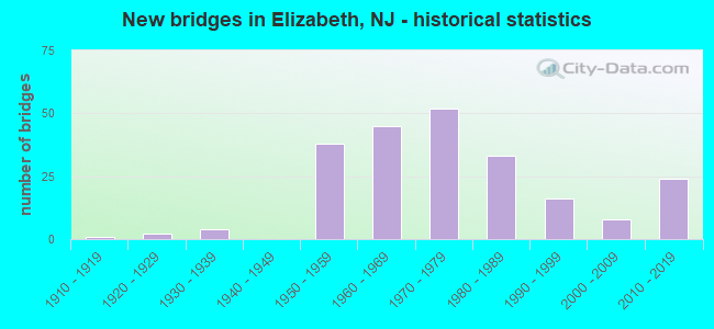
- New bridges - historical statistics
- 11910-1919
- 21920-1929
- 41930-1939
- 381950-1959
- 451960-1969
- 521970-1979
- 331980-1989
- 161990-1999
- 82000-2009
- 242010-2019

- Reconstructed bridges - Historical Statistics
- 11950-1959
- 01960-1969
- 11970-1979
- 311980-1989
- 181990-1999
- 132000-2009
- 22010-2019


- Bridge Condition - Deck
- 7.6%Excellent
- 2.5%Very good
- 61.3%Good
- 22.7%Satisfactory
- 3.4%Fair
- 2.5%Poor

- Bridge Condition - Superstructure
- 6.7%Excellent
- 3.4%Very good
- 29.4%Good
- 48.7%Satisfactory
- 10.1%Fair
- 1.7%Poor
- 0.8%Serious

- Bridge Condition - Substructure
- 6.7%Excellent
- 0.8%Very good
- 14.3%Good
- 52.1%Satisfactory
- 24.4%Fair
- 1.7%Poor

- Bridge Condition - Channel
- 11.1%Excellent
- 25.9%Very good
- 59.3%Good
- 3.7%Satisfactory
Find on map >> Show street view
Structure Number: 200215, Location: 1.52 MI NORTH OF RT I-278 (Lat: 40.655950, Lng: -74.208681), Route carried "on" structure: US 1, Year Built: 2006, Status: Open, Structure Length: 57.30m (187.99ft), Average Daily Traffic: 56,065 (year 2021), Truck Traffic: 4%, Average Future Daily Traffic: 67,277 (year 2041), Design Load: HL 93, Features Intersected: ELIZABETH RV & LOCAL STS
Minimum Vertical Clearance: 30+ m (98+ ft), Kilometerpoint: 70.521, Lanes on structure: 6, Lanes under structure: 8, Base Highway Network: Yes, Owner: State Highway Agency, Approaching Roadway Width: 30.5m (100.1ft), Skew: 39 degrees, Material/Design: Steel continuous, Design/Construction: Stringer/Multi-beam, Number Of Spans In Main Unit: 16, Length of Maximum Span: 56.4m (185.0ft), Curb-To-Curb Width: 30.6m (100.4ft), Out-to-Out Width: 32.8m (107.6ft)
Condition: Deck: Good, Superstructure: Good, Substructure: Good, Channel: Very good, Operating Rating: 49.9 metric tons, Method Used To Determine Operating Rating: Load and Resistance Factor Rating (LRFR) rating reported by rating factor(RF) method using HL-93 loadings, Inventory Rating: 38.6 metric tons, Method Used To Determine Inventory Rating: Load and Resistance Factor Rating (LRFR) rating reported by rating factor(RF) method using HL-93 loadings, Structural Evaluation: Better than present minimum criteria, Deck Geometry: Superior to present desirable criteria, Underclear: Meets minimum limits, Waterway Adequacy: Superior to present desirable criteria, Approach Roadway Alignment: Equal to present desirable criteria, Designated Inspection Frequency: Every 24 months, Inspection Date: March 2021, Deck Structure Type: Concrete Cast-file-Place, Wearing Surface/Protective System: Wearing Surface: Monolithic Concrete, Deck Protection: Epoxy Coated Reinforcing
Find on map >> Show street view
Structure Number: 2002152, Location: 0.8 MI South of CR 624 (Lat: 40.666961, Lng: -74.204289), Route carried "on" structure: City street , Year Built: 2007, Status: Open, Structure Length: 4.11m (13.48ft), Average Daily Traffic: 11,318 (year 2021), Truck Traffic: 3%, Average Future Daily Traffic: 13,582 (year 2041), Design Load: HL 93, Features Intersected: US 1&9, Facility Carried by Structure: MAGNOLIA AVENUE
Minimum Vertical Clearance: 30+ m (98+ ft), Kilometerpoint: 1.529, Lanes on structure: 2, Lanes under structure: 6, Owner: State Highway Agency, Approaching Roadway Width: 9.1m (29.9ft), Material/Design: Steel, Design/Construction: Stringer/Multi-beam, Number Of Spans In Main Unit: 1, Length of Maximum Span: 39.6m (129.9ft), Curb or Sidewalk Widths: Left: 1.8m (5.9ft), Right: 1.8m (5.9ft), Curb-To-Curb Width: 9.1m (29.9ft), Out-to-Out Width: 13.5m (44.3ft)
Condition: Deck: Good, Superstructure: Very good, Substructure: Good, Operating Rating: 73.2 metric tons, Method Used To Determine Operating Rating: Load and Resistance Factor Rating (LRFR) rating reported by rating factor(RF) method using HL-93 loadings, Inventory Rating: 56.4 metric tons, Method Used To Determine Inventory Rating: Load and Resistance Factor Rating (LRFR) rating reported by rating factor(RF) method using HL-93 loadings, Structural Evaluation: Better than present minimum criteria, Deck Geometry: High priority of corrective action, Underclear: High priority of corrective action, Approach Roadway Alignment: Better than present minimum criteria, Length Of Structure Improvement: 4.11m (13.48ft), Designated Inspection Frequency: Every 24 months, Inspection Date: May 2021, Bridge Improvement Cost: $18,000, Total Project Cost: $23,000 ( Estimate for 2021), Deck Structure Type: Concrete Cast-file-Place, Wearing Surface/Protective System: Wearing Surface: Monolithic Concrete, Deck Protection: Epoxy Coated Reinforcing
Find on map >> Show street view
Structure Number: 2004002, Location: 1 MI. N. OF I-278 (Lat: 40.642031, Lng: -74.198331), Route carried "on" structure: City street , Year Built: 2010, Status: Open, Structure Length: 3.20m (10.50ft), Average Daily Traffic: 3,444 (year 2020), Truck Traffic: 4%, Average Future Daily Traffic: 4,203 (year 2040), Design Load: HL 93, Features Intersected: ELIZABETH RIVER, Facility Carried by Structure: SOUTH FIRST STREET
Minimum Vertical Clearance: 30.18m (99.02ft), Kilometerpoint: 0.595, Lanes on structure: 2, Owner: County Highway Agency, Approaching Roadway Width: 10.8m (35.4ft), Material/Design: Prestressed concrete, Design/Construction: Box Beam or Girders - Multiple, Number Of Spans In Main Unit: 1, Length of Maximum Span: 25.9m (85.0ft), Curb or Sidewalk Widths: Left: 1.9m (6.2ft), Right: 0.0m, Curb-To-Curb Width: 10.8m (35.4ft), Out-to-Out Width: 13.5m (44.3ft)
Condition: Deck: Satisfactory, Superstructure: Good, Substructure: Good, Channel: Good, Operating Rating: 48.0 metric tons, Method Used To Determine Operating Rating: Load and Resistance Factor Rating (LRFR) rating reported by rating factor(RF) method using HL-93 loadings, Inventory Rating: 38.2 metric tons, Method Used To Determine Inventory Rating: Load and Resistance Factor Rating (LRFR) rating reported by rating factor(RF) method using HL-93 loadings, Structural Evaluation: Better than present minimum criteria, Deck Geometry: Somewhat better than minimum adequacy, Waterway Adequacy: Superior to present desirable criteria, Approach Roadway Alignment: Equal to present minimum criteria, Designated Inspection Frequency: Every 24 months, Underwater Inspection Frequency: Every 48 months, Inspection Date: March 2020, Underwater Inspection Date: June 2018, Deck Structure Type: Concrete Cast-file-Place, Wearing Surface/Protective System: Wearing Surface: Monolithic Concrete, Deck Protection: Epoxy Coated Reinforcing
Find on map >> Show street view
Structure Number: 2004004, Location: SUMMER ST AT ELIZABETH RV (Lat: 40.650000, Lng: -74.209811), Route carried "on" structure: City street , Year Built: 1932, Year Reconstructed: 2015, Status: Open, Structure Length: 2.32m (7.61ft), Average Daily Traffic: 5,004 (year 2020), Truck Traffic: 3%, Average Future Daily Traffic: 6,106 (year 2040), Design Load: HS 20, Features Intersected: ELIZABETH RIVER, Facility Carried by Structure: SUMMER STREET
Minimum Vertical Clearance: 30+ m (98+ ft), Kilometerpoint: 0.885, Lanes on structure: 2, Owner: County Highway Agency, Approaching Roadway Width: 14.0m (45.9ft), Material/Design: Steel, Design/Construction: Stringer/Multi-beam, Number Of Spans In Main Unit: 1, Length of Maximum Span: 21.3m (69.9ft), Curb or Sidewalk Widths: Left: 1.8m (5.9ft), Right: 1.8m (5.9ft), Curb-To-Curb Width: 14.0m (45.9ft), Out-to-Out Width: 18.3m (60.0ft)
Condition: Deck: Good, Superstructure: Good, Substructure: Fair, Channel: Very good, Operating Rating: 89.8 metric tons, Method Used To Determine Operating Rating: Load Factor (LF), Inventory Rating: 53.5 metric tons, Method Used To Determine Inventory Rating: Load Factor (LF), Structural Evaluation: Somewhat better than minimum adequacy, Deck Geometry: Superior to present desirable criteria, Waterway Adequacy: Equal to present desirable criteria, Approach Roadway Alignment: Equal to present minimum criteria, Designated Inspection Frequency: Every 24 months, Underwater Inspection Frequency: Every 48 months, Inspection Date: April 2020, Underwater Inspection Date: June 2018, Deck Structure Type: Concrete Cast-file-Place, Wearing Surface/Protective System: Wearing Surface: Monolithic Concrete, Deck Protection: Epoxy Coated Reinforcing
Find on map >> Show street view
Structure Number: 2004005, Location: NEAR PEARL STREET (Lat: 40.658069, Lng: -74.210561), Route carried "on" structure: City street , Year Built: 1984, Status: Open, Structure Length: 1.74m (5.71ft), Average Daily Traffic: 19,189 (year 2020), Truck Traffic: 3%, Average Future Daily Traffic: 23,415 (year 2040), Features Intersected: ELIZABETH RIVER, Facility Carried by Structure: SOUTH STREET
Minimum Vertical Clearance: 30+ m (98+ ft), Kilometerpoint: 2.639, Lanes on structure: 3, Owner: County Highway Agency, Approaching Roadway Width: 11.0m (36.1ft), Skew: 1 degrees, Material/Design: Prestressed concrete, Design/Construction: Box Beam or Girders - Multiple, Number Of Spans In Main Unit: 1, Length of Maximum Span: 16.2m (53.1ft), Curb or Sidewalk Widths: Left: 2.1m (6.9ft), Right: 2.1m (6.9ft), Curb-To-Curb Width: 11.0m (36.1ft), Out-to-Out Width: 15.8m (51.8ft)
Condition: Deck: Satisfactory, Superstructure: Satisfactory, Substructure: Satisfactory, Channel: Good, Operating Rating: 68.9 metric tons, Method Used To Determine Operating Rating: Load Factor (LF), Inventory Rating: 40.8 metric tons, Method Used To Determine Inventory Rating: Load Factor (LF), Structural Evaluation: Equal to present minimum criteria, Deck Geometry: High priority of replacement, Waterway Adequacy: Equal to present desirable criteria, Approach Roadway Alignment: Better than present minimum criteria, Length Of Structure Improvement: 1.74m (5.71ft), Designated Inspection Frequency: Every 24 months, Underwater Inspection Frequency: Every 48 months, Inspection Date: March 2020, Underwater Inspection Date: June 2018, Bridge Improvement Cost: $63,000, Roadway Improvement Cost: $10,000, Total Project Cost: $104,000 ( Estimate for 2020), Deck Structure Type: Concrete Cast-file-Place, Wearing Surface/Protective System: Wearing Surface: Monolithic Concrete, Deck Protection: Epoxy Coated Reinforcing
Find on map >> Show street view
Structure Number: 2004006, Location: NEAR PEARL STREET (Lat: 40.660931, Lng: -74.211500), Route carried "on" structure: City street , Year Built: 1984, Status: Open, Structure Length: 1.74m (5.71ft), Average Daily Traffic: 11,966 (year 2020), Truck Traffic: 3%, Average Future Daily Traffic: 14,601 (year 2040), Design Load: HS 20+Mod, Features Intersected: ELIZABETH RIVER, Facility Carried by Structure: BRIDGE STREET
Minimum Vertical Clearance: 30+ m (98+ ft), Kilometerpoint: 0.064, Lanes on structure: 2, Owner: County Highway Agency, Approaching Roadway Width: 12.2m (40.0ft), Skew: 1 degrees, Material/Design: Prestressed concrete, Design/Construction: Box Beam or Girders - Multiple, Number Of Spans In Main Unit: 1, Length of Maximum Span: 16.2m (53.1ft), Curb or Sidewalk Widths: Left: 2.7m (8.9ft), Right: 2.7m (8.9ft), Curb-To-Curb Width: 12.2m (40.0ft), Out-to-Out Width: 18.3m (60.0ft)
Condition: Deck: Satisfactory, Superstructure: Satisfactory, Substructure: Satisfactory, Channel: Good, Operating Rating: 80.7 metric tons, Method Used To Determine Operating Rating: Load Factor (LF), Inventory Rating: 48.1 metric tons, Method Used To Determine Inventory Rating: Load Factor (LF), Structural Evaluation: Equal to present minimum criteria, Deck Geometry: Somewhat better than minimum adequacy, Waterway Adequacy: Equal to present desirable criteria, Approach Roadway Alignment: Better than present minimum criteria, Designated Inspection Frequency: Every 24 months, Underwater Inspection Frequency: Every 48 months, Inspection Date: March 2020, Underwater Inspection Date: June 2018, Deck Structure Type: Concrete Cast-file-Place, Wearing Surface/Protective System: Wearing Surface: Monolithic Concrete, Deck Protection: Epoxy Coated Reinforcing
Find on map >> Show street view
Structure Number: 2004007, Location: NEAR ELIZABETH AVENUE (Lat: 40.660889, Lng: -74.215011), Route carried "on" structure: County highway 623, Year Built: 1984, Status: Open, Structure Length: 1.71m (5.61ft), Average Daily Traffic: 8,293 (year 2020), Truck Traffic: 4%, Average Future Daily Traffic: 10,119 (year 2040), Features Intersected: ELIZABETH RIVER
Minimum Vertical Clearance: 30+ m (98+ ft), Kilometerpoint: 1.497, Lanes on structure: 3, Owner: County Highway Agency, Approaching Roadway Width: 20.3m (66.6ft), Material/Design: Prestressed concrete, Design/Construction: Box Beam or Girders - Multiple, Number Of Spans In Main Unit: 1, Length of Maximum Span: 15.8m (51.8ft), Curb or Sidewalk Widths: Left: 4.5m (14.8ft), Right: 3.3m (10.8ft), Curb-To-Curb Width: 20.3m (66.6ft), Out-to-Out Width: 28.8m (94.5ft)
Condition: Deck: Satisfactory, Superstructure: Good, Substructure: Satisfactory, Channel: Good, Inventory Rating: 59.9 metric tons, Method Used To Determine Inventory Rating: Load Factor (LF), Structural Evaluation: Equal to present minimum criteria, Deck Geometry: Superior to present desirable criteria, Waterway Adequacy: Equal to present desirable criteria, Approach Roadway Alignment: Better than present minimum criteria, Designated Inspection Frequency: Every 24 months, Underwater Inspection Frequency: Every 48 months, Inspection Date: March 2020, Underwater Inspection Date: June 2018, Deck Structure Type: Concrete Cast-file-Place, Wearing Surface/Protective System: Wearing Surface: Other, Deck Protection: Epoxy Coated Reinforcing
Find on map >> Show street view
Structure Number: 2004008, Location: NEAR SOUTH BROAD STREET (Lat: 40.661669, Lng: -74.217511), Route carried "on" structure: City street , Year Built: 1984, Status: Open, Structure Length: 1.92m (6.30ft), Average Daily Traffic: 9,355 (year 2020), Truck Traffic: 4%, Average Future Daily Traffic: 11,415 (year 2040), Design Load: HS 20+Mod, Features Intersected: ELIZABETH RIVER, Facility Carried by Structure: RAHWAY AVENUE
Minimum Vertical Clearance: 30+ m (98+ ft), Kilometerpoint: 0.177, Lanes on structure: 1, Owner: County Highway Agency, Approaching Roadway Width: 12.2m (40.0ft), Skew: 2 degrees, Material/Design: Prestressed concrete, Design/Construction: Box Beam or Girders - Multiple, Number Of Spans In Main Unit: 1, Length of Maximum Span: 18.0m (59.1ft), Curb or Sidewalk Widths: Left: 3.7m (12.1ft), Right: 3.7m (12.1ft), Curb-To-Curb Width: 12.2m (40.0ft), Out-to-Out Width: 20.1m (65.9ft)
Condition: Deck: Good, Superstructure: Satisfactory, Substructure: Satisfactory, Channel: Very good, Operating Rating: 77.1 metric tons, Method Used To Determine Operating Rating: Load Factor (LF), Inventory Rating: 46.3 metric tons, Method Used To Determine Inventory Rating: Load Factor (LF), Structural Evaluation: Equal to present minimum criteria, Deck Geometry: Somewhat better than minimum adequacy, Waterway Adequacy: Equal to present desirable criteria, Approach Roadway Alignment: Better than present minimum criteria, Designated Inspection Frequency: Every 24 months, Inspection Date: March 2020, Deck Structure Type: Concrete Cast-file-Place, Wearing Surface/Protective System: Wearing Surface: Other, Deck Protection: Epoxy Coated Reinforcing
Find on map >> Show street view
Structure Number: 2004009, Location: NEAR CHERRY STREET (Lat: 40.663169, Lng: -74.218861), Route carried "on" structure: City street , Year Built: 1984, Status: Open, Structure Length: 1.71m (5.61ft), Average Daily Traffic: 4,485 (year 2020), Truck Traffic: 1%, Average Future Daily Traffic: 5,473 (year 2040), Design Load: HS 20+Mod, Features Intersected: ELIZABETH RIVER, Facility Carried by Structure: MURRAY STREET
Minimum Vertical Clearance: 30+ m (98+ ft), Kilometerpoint: 0.000, Lanes on structure: 2, Owner: County Highway Agency, Approaching Roadway Width: 11.0m (36.1ft), Material/Design: Prestressed concrete, Design/Construction: Box Beam or Girders - Multiple, Number Of Spans In Main Unit: 1, Length of Maximum Span: 15.8m (51.8ft), Curb or Sidewalk Widths: Left: 3.4m (11.2ft), Right: 3.4m (11.2ft), Curb-To-Curb Width: 11.0m (36.1ft), Out-to-Out Width: 18.3m (60.0ft)
Condition: Deck: Satisfactory, Superstructure: Good, Substructure: Satisfactory, Channel: Good, Operating Rating: 72.6 metric tons, Method Used To Determine Operating Rating: Load Factor (LF), Inventory Rating: 43.5 metric tons, Method Used To Determine Inventory Rating: Load Factor (LF), Structural Evaluation: Equal to present minimum criteria, Deck Geometry: Somewhat better than minimum adequacy, Waterway Adequacy: Equal to present desirable criteria, Approach Roadway Alignment: Equal to present desirable criteria, Designated Inspection Frequency: Every 24 months, Inspection Date: March 2020, Deck Structure Type: Concrete Cast-file-Place, Wearing Surface/Protective System: Wearing Surface: Monolithic Concrete, Deck Protection: Epoxy Coated Reinforcing
Find on map >> Show street view
Structure Number: 200401, Location: NEAR CHERRY STREET (Lat: 40.664561, Lng: -74.218889), Route carried "on" structure: City street , Year Built: 1984, Status: Open, Structure Length: 1.80m (5.91ft), Average Daily Traffic: 10,699 (year 2020), Truck Traffic: 4%, Average Future Daily Traffic: 13,055 (year 2040), Design Load: HS 20+Mod, Features Intersected: ELIZABETH RIVER, Facility Carried by Structure: WEST JERSEY STREET
Minimum Vertical Clearance: 30+ m (98+ ft), Kilometerpoint: 0.097, Lanes on structure: 2, Owner: County Highway Agency, Approaching Roadway Width: 11.0m (36.1ft), Skew: 1 degrees, Material/Design: Prestressed concrete, Design/Construction: Box Beam or Girders - Multiple, Number Of Spans In Main Unit: 1, Length of Maximum Span: 16.8m (55.1ft), Curb or Sidewalk Widths: Left: 3.4m (11.2ft), Right: 3.4m (11.2ft), Curb-To-Curb Width: 11.0m (36.1ft), Out-to-Out Width: 18.3m (60.0ft)
Condition: Deck: Satisfactory, Superstructure: Satisfactory, Substructure: Satisfactory, Channel: Good, Operating Rating: 69.9 metric tons, Method Used To Determine Operating Rating: Load Factor (LF), Inventory Rating: 41.7 metric tons, Method Used To Determine Inventory Rating: Load Factor (LF), Structural Evaluation: Equal to present minimum criteria, Deck Geometry: Meets minimum limits, Waterway Adequacy: Equal to present desirable criteria, Approach Roadway Alignment: Equal to present desirable criteria, Designated Inspection Frequency: Every 24 months, Inspection Date: March 2020, Deck Structure Type: Concrete Cast-file-Place, Wearing Surface/Protective System: Wearing Surface: Monolithic Concrete, Deck Protection: Epoxy Coated Reinforcing
Find on map >> Show street view
Structure Number: 2004011, Location: NEAR PRICE STREET (Lat: 40.666281, Lng: -74.218531), Route carried "on" structure: City street , Year Built: 1984, Status: Open, Structure Length: 1.40m (4.59ft), Average Daily Traffic: 10,202 (year 2020), Truck Traffic: 4%, Average Future Daily Traffic: 12,449 (year 2040), Design Load: HS 20+Mod, Features Intersected: ELIZABETH RIVER, Facility Carried by Structure: WEST GRAND STREET
Minimum Vertical Clearance: 30+ m (98+ ft), Kilometerpoint: 0.177, Lanes on structure: 2, Owner: County Highway Agency, Approaching Roadway Width: 9.9m (32.5ft), Material/Design: Prestressed concrete, Design/Construction: Slab, Number Of Spans In Main Unit: 1, Length of Maximum Span: 12.8m (42.0ft), Curb or Sidewalk Widths: Left: 3.4m (11.2ft), Right: 3.4m (11.2ft), Curb-To-Curb Width: 9.9m (32.5ft), Out-to-Out Width: 17.4m (57.1ft)
Condition: Deck: Satisfactory, Superstructure: Good, Substructure: Satisfactory, Channel: Good, Operating Rating: 83.5 metric tons, Method Used To Determine Operating Rating: Load Factor (LF), Inventory Rating: 49.9 metric tons, Method Used To Determine Inventory Rating: Load Factor (LF), Structural Evaluation: Equal to present minimum criteria, Deck Geometry: Meets minimum limits, Waterway Adequacy: Equal to present desirable criteria, Approach Roadway Alignment: Equal to present desirable criteria, Designated Inspection Frequency: Every 24 months, Inspection Date: March 2020, Deck Structure Type: Concrete Cast-file-Place, Wearing Surface/Protective System: Wearing Surface: Monolithic Concrete, Deck Protection: Epoxy Coated Reinforcing
Find on map >> Show street view
Structure Number: 2004014, Location: NEAR SAYER STREET (Lat: 40.669850, Lng: -74.219019), Route carried "on" structure: County highway 629, Year Built: 1984, Status: Open, Structure Length: 1.40m (4.59ft), Average Daily Traffic: 14,863 (year 2020), Truck Traffic: 4%, Average Future Daily Traffic: 18,136 (year 2040), Design Load: HS 20+Mod, Features Intersected: ELIZABETH RIVER
Minimum Vertical Clearance: 30+ m (98+ ft), Kilometerpoint: 0.177, Lanes on structure: 2, Owner: County Highway Agency, Approaching Roadway Width: 12.8m (42.0ft), Material/Design: Prestressed concrete, Design/Construction: Slab, Number Of Spans In Main Unit: 1, Length of Maximum Span: 12.8m (42.0ft), Curb or Sidewalk Widths: Left: 3.0m (9.8ft), Right: 3.0m (9.8ft), Curb-To-Curb Width: 12.8m (42.0ft), Out-to-Out Width: 19.5m (64.0ft)
Condition: Deck: Satisfactory, Superstructure: Good, Substructure: Satisfactory, Channel: Good, Operating Rating: 83.5 metric tons, Method Used To Determine Operating Rating: Load Factor (LF), Inventory Rating: 49.9 metric tons, Method Used To Determine Inventory Rating: Load Factor (LF), Structural Evaluation: Equal to present minimum criteria, Deck Geometry: Somewhat better than minimum adequacy, Waterway Adequacy: Equal to present desirable criteria, Approach Roadway Alignment: Equal to present desirable criteria, Designated Inspection Frequency: Every 24 months, Inspection Date: March 2020, Deck Structure Type: Concrete Cast-file-Place, Wearing Surface/Protective System: Wearing Surface: Monolithic Concrete, Deck Protection: Epoxy Coated Reinforcing
Find on map >> Show street view
Structure Number: 2004015, Location: NEAR MORRIS AVENUE (Lat: 40.671061, Lng: -74.219489), Route carried "on" structure: City street , Year Built: 1984, Status: Open, Structure Length: 1.40m (4.59ft), Average Daily Traffic: 11,209 (year 2020), Truck Traffic: 4%, Average Future Daily Traffic: 13,678 (year 2040), Design Load: HS 20+Mod, Features Intersected: ELIZABETH RIVER, Facility Carried by Structure: IRVINGTON AVENUE
Minimum Vertical Clearance: 30+ m (98+ ft), Kilometerpoint: 0.064, Lanes on structure: 2, Owner: County Highway Agency, Approaching Roadway Width: 10.7m (35.1ft), Material/Design: Prestressed concrete, Design/Construction: Slab, Number Of Spans In Main Unit: 1, Length of Maximum Span: 12.8m (42.0ft), Curb or Sidewalk Widths: Left: 3.5m (11.5ft), Right: 3.5m (11.5ft), Curb-To-Curb Width: 10.7m (35.1ft), Out-to-Out Width: 18.3m (60.0ft)
Condition: Deck: Satisfactory, Superstructure: Good, Substructure: Satisfactory, Channel: Very good, Operating Rating: 84.4 metric tons, Method Used To Determine Operating Rating: Load Factor (LF), Inventory Rating: 50.8 metric tons, Method Used To Determine Inventory Rating: Load Factor (LF), Structural Evaluation: Equal to present minimum criteria, Deck Geometry: Meets minimum limits, Waterway Adequacy: Equal to present desirable criteria, Approach Roadway Alignment: Equal to present desirable criteria, Designated Inspection Frequency: Every 24 months, Inspection Date: March 2020, Deck Structure Type: Concrete Cast-file-Place, Wearing Surface/Protective System: Wearing Surface: Monolithic Concrete, Deck Protection: Epoxy Coated Reinforcing
Find on map >> Show street view
Structure Number: 2004016, Location: NEAR HILLSIDE LINE (Lat: 40.675000, Lng: -74.222250), Route carried "on" structure: City street , Year Built: 1984, Status: Open, Structure Length: 1.89m (6.20ft), Average Daily Traffic: 1,884 (year 2020), Truck Traffic: 1%, Average Future Daily Traffic: 2,299 (year 2040), Design Load: HS 20, Features Intersected: ELIZABETH RIVER, Facility Carried by Structure: TROTTERS LANE
Minimum Vertical Clearance: 30+ m (98+ ft), Kilometerpoint: 0.000, Lanes on structure: 2, Owner: County Highway Agency, Approaching Roadway Width: 11.0m (36.1ft), Skew: 4 degrees, Material/Design: Prestressed concrete, Design/Construction: Box Beam or Girders - Multiple, Number Of Spans In Main Unit: 1, Length of Maximum Span: 17.7m (58.1ft), Curb or Sidewalk Widths: Left: 1.8m (5.9ft), Right: 1.8m (5.9ft), Curb-To-Curb Width: 11.0m (36.1ft), Out-to-Out Width: 15.2m (49.9ft)
Condition: Deck: Satisfactory, Superstructure: Good, Substructure: Satisfactory, Channel: Very good, Operating Rating: 84.4 metric tons, Method Used To Determine Operating Rating: Load Factor (LF), Inventory Rating: 50.8 metric tons, Method Used To Determine Inventory Rating: Load Factor (LF), Structural Evaluation: Equal to present minimum criteria, Deck Geometry: Equal to present minimum criteria, Waterway Adequacy: Equal to present desirable criteria, Approach Roadway Alignment: Equal to present minimum criteria, Designated Inspection Frequency: Every 24 months, Inspection Date: March 2020, Deck Structure Type: Concrete Cast-file-Place, Wearing Surface/Protective System: Wearing Surface: Monolithic Concrete, Deck Protection: Epoxy Coated Reinforcing
Find on map >> Show street view
Structure Number: 2004018, Location: TRENTON AVE AT ELIZ RIV (Lat: 40.647331, Lng: -74.205031), Route carried "on" structure: City street , Year Built: 1951, Year Reconstructed: 1981, Status: Open, Structure Length: 4.60m (15.09ft), Average Daily Traffic: 15,816 (year 2020), Truck Traffic: 1%, Average Future Daily Traffic: 19,299 (year 2040), Design Load: HS 20, Features Intersected: ELIZABETH RIVER, Facility Carried by Structure: TRENTON AVENUE
Minimum Vertical Clearance: 30+ m (98+ ft), Kilometerpoint: 0.000, Lanes on structure: 2, Owner: County Highway Agency, Approaching Roadway Width: 14.6m (47.9ft), Material/Design: Steel, Design/Construction: Stringer/Multi-beam, Number Of Spans In Main Unit: 3, Length of Maximum Span: 25.3m (83.0ft), Curb or Sidewalk Widths: Left: 1.8m (5.9ft), Right: 1.8m (5.9ft), Curb-To-Curb Width: 14.6m (47.9ft), Out-to-Out Width: 18.9m (62.0ft)
Condition: Deck: Fair, Superstructure: Poor, Substructure: Fair, Channel: Very good, Operating Rating: 64.4 metric tons, Method Used To Determine Operating Rating: Load Factor (LF), Inventory Rating: 38.1 metric tons, Method Used To Determine Inventory Rating: Load Factor (LF), Structural Evaluation: Meets minimum limits, Deck Geometry: Superior to present desirable criteria, Waterway Adequacy: Equal to present desirable criteria, Approach Roadway Alignment: Equal to present minimum criteria, Length Of Structure Improvement: 4.60m (15.09ft), Designated Inspection Frequency: Every 24 months, Underwater Inspection Frequency: Every 48 months, Inspection Date: March 2020, Underwater Inspection Date: March 2020, Bridge Improvement Cost: $3,089,000, Roadway Improvement Cost: $463,000, Total Project Cost: $4,974,000 ( Estimate for 2020), Deck Structure Type: Concrete Cast-file-Place, Wearing Surface/Protective System: Wearing Surface: Monolithic Concrete
Find on map >> Show street view
Structure Number: 2004101, Location: 0.2 mi west of NJTP (Lat: 40.669639, Lng: -74.181350), Route carried "on" structure: Ramp City street , Year Built: 1999, Status: Open, Structure Length: 2.99m (9.81ft), Average Daily Traffic: 9,187 (year 2020), Truck Traffic: 1%, Average Future Daily Traffic: 11,209 (year 2040), Design Load: HS 25 or greater, Features Intersected: EARHART DRIVE, Facility Carried by Structure: JERSEY GARDENS BLV
Minimum Vertical Clearance: 30+ m (98+ ft), Kilometerpoint: 0.000, Lanes on structure: 2, Lanes under structure: 2, Owner: City or Municipal Highway Agency, Approaching Roadway Width: 7.9m (25.9ft), Skew: 1 degrees, Material/Design: Steel, Design/Construction: Stringer/Multi-beam, Number Of Spans In Main Unit: 1, Length of Maximum Span: 28.3m (92.8ft), Curb-To-Curb Width: 7.9m (25.9ft), Out-to-Out Width: 9.1m (29.9ft)
Condition: Deck: Good, Superstructure: Good, Substructure: Good, Inventory Rating: 81.6 metric tons, Method Used To Determine Inventory Rating: Load Factor (LF), Structural Evaluation: Better than present minimum criteria, Deck Geometry: High priority of replacement, Underclear: Somewhat better than minimum adequacy, Approach Roadway Alignment: Equal to present minimum criteria, Length Of Structure Improvement: 2.99m (9.81ft), Designated Inspection Frequency: Every 24 months, Inspection Date: March 2020, Bridge Improvement Cost: $73,000, Roadway Improvement Cost: $11,000, Total Project Cost: $117,000 ( Estimate for 2020), Deck Structure Type: Concrete Cast-file-Place, Wearing Surface/Protective System: Wearing Surface: Monolithic Concrete, Deck Protection: Epoxy Coated Reinforcing
Find on map >> Show street view
Structure Number: 2004102, Location: 0.1MI E OF NJTP EXIT 13A (Lat: 40.663689, Lng: -74.180361), Route carried "on" structure: City street , Year Built: 1998, Status: Open, Structure Length: 16.40m (53.81ft), Average Daily Traffic: 13,787 (year 2020), Truck Traffic: 1%, Average Future Daily Traffic: 16,823 (year 2040), Design Load: HS 25 or greater, Features Intersected: CONRAIL & NORFOLK S RR, Facility Carried by Structure: JERSEY GARDENS BLV
Minimum Vertical Clearance: 30+ m (98+ ft), Kilometerpoint: 0.000, Lanes on structure: 4, Owner: City or Municipal Highway Agency, Approaching Roadway Width: 22.6m (74.1ft), Skew: 9 degrees, Material/Design: Steel, Design/Construction: Stringer/Multi-beam, Number Of Spans In Main Unit: 4, Length of Maximum Span: 51.5m (169.0ft), Curb or Sidewalk Widths: Left: 0.2m (0.7ft), Right: 0.2m (0.7ft), Curb-To-Curb Width: 22.6m (74.1ft), Out-to-Out Width: 23.7m (77.8ft)
Condition: Deck: Good, Superstructure: Very good, Substructure: Satisfactory, Operating Rating: 87.1 metric tons, Method Used To Determine Operating Rating: Load Factor (LF), Inventory Rating: 51.7 metric tons, Method Used To Determine Inventory Rating: Load Factor (LF), Structural Evaluation: Equal to present minimum criteria, Deck Geometry: Superior to present desirable criteria, Underclear: Better than present minimum criteria, Approach Roadway Alignment: Better than present minimum criteria, Designated Inspection Frequency: Every 24 months, Inspection Date: April 2020, Deck Structure Type: Concrete Cast-file-Place, Wearing Surface/Protective System: Wearing Surface: Monolithic Concrete, Deck Protection: Epoxy Coated Reinforcing
Find on map >> Show street view
Structure Number: 2004103, Location: 0.2 mi east of NJTP (Lat: 40.661011, Lng: -74.180000), Route carried "on" structure: City street , Year Built: 1997, Status: Open, Structure Length: 13.75m (45.11ft), Average Daily Traffic: 9,187 (year 2020), Truck Traffic: 1%, Average Future Daily Traffic: 11,209 (year 2040), Design Load: HS 25 or greater, Features Intersected: NORFOLK So. RR, ACCES RD, Facility Carried by Structure: VET. MEM. DRIVE
Minimum Vertical Clearance: 30+ m (98+ ft), Kilometerpoint: 0.000, Lanes on structure: 4, Lanes under structure: 2, Owner: City or Municipal Highway Agency, Approaching Roadway Width: 15.2m (49.9ft), Skew: 9 degrees, Material/Design: Steel, Design/Construction: Stringer/Multi-beam, Number Of Spans In Main Unit: 4, Length of Maximum Span: 42.1m (138.1ft), Curb or Sidewalk Widths: Left: 0.2m (0.7ft), Right: 2.1m (6.9ft), Curb-To-Curb Width: 15.2m (49.9ft), Out-to-Out Width: 18.2m (59.7ft)
Condition: Deck: Good, Superstructure: Very good, Substructure: Satisfactory, Operating Rating: 41.7 metric tons, Method Used To Determine Operating Rating: Load Factor (LF), Inventory Rating: 25.4 metric tons, Method Used To Determine Inventory Rating: Load Factor (LF), Structural Evaluation: Equal to present minimum criteria, Deck Geometry: High priority of corrective action, Underclear: Better than present minimum criteria, Approach Roadway Alignment: Better than present minimum criteria, Designated Inspection Frequency: Every 24 months, Inspection Date: April 2020, Deck Structure Type: Concrete Cast-file-Place, Wearing Surface/Protective System: Wearing Surface: Monolithic Concrete, Deck Protection: Epoxy Coated Reinforcing
Find on map >> Show street view
Structure Number: 200715, Location: 0.1 mi north of NJ 28 (Lat: 40.667961, Lng: -74.219439), Route carried "on" structure: State highway 27, Year Built: 1978, Status: Open, Structure Length: 1.40m (4.59ft), Average Daily Traffic: 14,700 (year 2020), Truck Traffic: 4%, Average Future Daily Traffic: 17,600 (year 2040), Design Load: HS 20+Mod, Features Intersected: ELIZABETH RIVER
Minimum Vertical Clearance: 30+ m (98+ ft), Kilometerpoint: 54.943, Lanes on structure: 2, Base Highway Network: Yes, Owner: State Highway Agency, Approaching Roadway Width: 11.0m (36.1ft), Material/Design: Prestressed concrete, Design/Construction: Slab, Number Of Spans In Main Unit: 1, Length of Maximum Span: 12.8m (42.0ft), Curb or Sidewalk Widths: Left: 3.3m (10.8ft), Right: 3.3m (10.8ft), Curb-To-Curb Width: 11.1m (36.4ft), Out-to-Out Width: 18.3m (60.0ft)
Condition: Deck: Satisfactory, Superstructure: Good, Substructure: Satisfactory, Channel: Excellent, Operating Rating: 68.9 metric tons, Method Used To Determine Operating Rating: Load Factor (LF), Inventory Rating: 34.5 metric tons, Method Used To Determine Inventory Rating: Load Factor (LF), Structural Evaluation: Equal to present minimum criteria, Deck Geometry: Meets minimum limits, Waterway Adequacy: Superior to present desirable criteria, Approach Roadway Alignment: Equal to present desirable criteria, Designated Inspection Frequency: Every 24 months, Inspection Date: June 2020, Deck Structure Type: Concrete Cast-file-Place, Wearing Surface/Protective System: Deck Protection: Epoxy Coated Reinforcing
Find on map >> Show street view
Structure Number: 2007151, Location: 3.37 MI SOUTH OF I-78 JCT (Lat: 40.666561, Lng: -74.220739), Route carried "on" structure: State highway 27, Year Built: 1920, Year Reconstructed: 1964, Status: Open, Structure Length: 2.96m (9.71ft), Average Daily Traffic: 11,451 (year 2019), Truck Traffic: 4%, Average Future Daily Traffic: 13,972 (year 2039), Features Intersected: former CNJRR (ABAND)
Minimum Vertical Clearance: 4.51m (14.80ft), Kilometerpoint: 54.718, Lanes on structure: 2, Base Highway Network: Yes, Owner: State Highway Agency, Approaching Roadway Width: 11.0m (36.1ft), Material/Design: Steel, Design/Construction: Truss - Thru, Number Of Spans In Main Unit: 1, Length of Maximum Span: 27.7m (90.9ft), Curb or Sidewalk Widths: Left: 2.2m (7.2ft), Right: 2.9m (9.5ft), Curb-To-Curb Width: 11.0m (36.1ft), Out-to-Out Width: 11.2m (36.7ft)
Condition: Deck: Poor, Superstructure: Serious, Substructure: Poor, Operating Rating: 41.7 metric tons, Method Used To Determine Operating Rating: Load Factor (LF), Inventory Rating: 25.4 metric tons, Method Used To Determine Inventory Rating: Load Factor (LF), Structural Evaluation: High priority of corrective action, Deck Geometry: Equal to present minimum criteria, Approach Roadway Alignment: Equal to present minimum criteria, Length Of Structure Improvement: 3.81m (12.50ft), Designated Inspection Frequency: Every 24 months, Critical Feature Inspection Frequency: Every 24 months, Other Special Inspection Frequency: Every 12 months, Inspection Date: June 2021, Critical Feature Inspection Date: June 2021, Other Special Inspection Date: June 2021, Bridge Improvement Cost: $3,339,000, Roadway Improvement Cost: $334,000, Total Project Cost: $5,009,000 ( Estimate for 2019), Deck Structure Type: Concrete Cast-file-Place, Wearing Surface/Protective System: Wearing Surface: Monolithic Concrete
Find on map >> Show street view
Structure Number: 2013154, Location: 0.9MI SOUTH OF RT 27 (Lat: 40.677289, Lng: -74.225711), Route carried "on" structure: State highway 439, Year Built: 1986, Status: Open, Structure Length: 1.34m (4.40ft), Average Daily Traffic: 24,355 (year 2021), Truck Traffic: 4%, Average Future Daily Traffic: 29,225 (year 2041), Design Load: HS 20, Features Intersected: ELIZABETH RIVER
Minimum Vertical Clearance: 30+ m (98+ ft), Kilometerpoint: 4.844, Lanes on structure: 4, Base Highway Network: Yes, Owner: State Highway Agency, Approaching Roadway Width: 14.0m (45.9ft), Material/Design: Prestressed concrete, Design/Construction: Box Beam or Girders - Multiple, Number Of Spans In Main Unit: 1, Length of Maximum Span: 12.8m (42.0ft), Curb or Sidewalk Widths: Left: 1.8m (5.9ft), Right: 1.8m (5.9ft), Curb-To-Curb Width: 14.0m (45.9ft), Out-to-Out Width: 18.3m (60.0ft)
Condition: Deck: Satisfactory, Superstructure: Good, Substructure: Good, Channel: Satisfactory, Operating Rating: 78.0 metric tons, Method Used To Determine Operating Rating: Load Factor (LF), Inventory Rating: 47.2 metric tons, Method Used To Determine Inventory Rating: Load Factor (LF), Structural Evaluation: Better than present minimum criteria, Deck Geometry: High priority of replacement, Waterway Adequacy: Equal to present desirable criteria, Approach Roadway Alignment: Equal to present desirable criteria, Length Of Structure Improvement: 1.34m (4.40ft), Designated Inspection Frequency: Every 24 months, Inspection Date: August 2021, Bridge Improvement Cost: $56,000, Roadway Improvement Cost: $6,000, Total Project Cost: $81,000 ( Estimate for 2021), Deck Structure Type: Concrete Cast-file-Place, Wearing Surface/Protective System: Wearing Surface: Monolithic Concrete, Deck Protection: Epoxy Coated Reinforcing
Find on map >> Show street view
Structure Number: 2019151, Location: 0.6 MI N OF NJTPK EX 13A (Lat: 40.676139, Lng: -74.191119), Route carried "on" structure: State highway 81, Year Built: 1982, Status: Open, Structure Length: 2.83m (9.28ft), Average Daily Traffic: 46,048 (year 2021), Truck Traffic: 20%, Average Future Daily Traffic: 56,188 (year 2041), Design Load: HS 20+Mod, Features Intersected: NORTH AVE. WB (CR 624)
Minimum Vertical Clearance: 30+ m (98+ ft), Kilometerpoint: 1.078, Lanes on structure: 6, Lanes under structure: 3, Base Highway Network: Yes, Owner: State Highway Agency, Approaching Roadway Width: 32.6m (107.0ft), Skew: 39 degrees, Material/Design: Steel, Design/Construction: Stringer/Multi-beam, Number Of Spans In Main Unit: 1, Length of Maximum Span: 27.1m (88.9ft), Curb-To-Curb Width: 32.2m (105.6ft), Out-to-Out Width: 34.8m (114.2ft)
Condition: Deck: Good, Superstructure: Satisfactory, Substructure: Satisfactory, Inventory Rating: 62.6 metric tons, Method Used To Determine Inventory Rating: Load Factor (LF), Structural Evaluation: Equal to present minimum criteria, Deck Geometry: Superior to present desirable criteria, Underclear: Equal to present minimum criteria, Approach Roadway Alignment: Equal to present desirable criteria, Designated Inspection Frequency: Every 24 months, Inspection Date: June 2021, Deck Structure Type: Concrete Cast-file-Place, Wearing Surface/Protective System: Wearing Surface: Monolithic Concrete, Deck Protection: Epoxy Coated Reinforcing
Find on map >> Show street view
Structure Number: 2019152, Location: 0.9 MI N OF NJTPK EX 13A (Lat: 40.677050, Lng: -74.191450), Route carried "on" structure: State highway 81, Year Built: 1982, Status: Open, Structure Length: 2.53m (8.30ft), Average Daily Traffic: 63,662 (year 2021), Truck Traffic: 5%, Average Future Daily Traffic: 77,680 (year 2041), Design Load: HS 20+Mod, Features Intersected: RAMP G
Minimum Vertical Clearance: 30+ m (98+ ft), Kilometerpoint: 1.207, Lanes on structure: 6, Lanes under structure: 1, Base Highway Network: Yes, Owner: State Highway Agency, Approaching Roadway Width: 32.9m (107.9ft), Skew: 35 degrees, Material/Design: Steel, Design/Construction: Stringer/Multi-beam, Number Of Spans In Main Unit: 1, Length of Maximum Span: 23.5m (77.1ft), Curb-To-Curb Width: 32.9m (107.9ft), Out-to-Out Width: 34.8m (114.2ft)
Condition: Deck: Good, Superstructure: Good, Substructure: Satisfactory, Inventory Rating: 59.0 metric tons, Method Used To Determine Inventory Rating: Load Factor (LF), Structural Evaluation: Equal to present minimum criteria, Deck Geometry: Superior to present desirable criteria, Underclear: Somewhat better than minimum adequacy, Approach Roadway Alignment: Equal to present desirable criteria, Designated Inspection Frequency: Every 24 months, Inspection Date: April 2021, Deck Structure Type: Concrete Cast-file-Place, Wearing Surface/Protective System: Wearing Surface: Monolithic Concrete, Deck Protection: Epoxy Coated Reinforcing
Find on map >> Show street view
Structure Number: 2019153, Location: 0.9 MI N OF NJTPK EX 13A (Lat: 40.679461, Lng: -74.192500), Route carried "on" structure: Ramp State highway 81, Year Built: 1982, Status: Open, Structure Length: 19.42m (63.71ft), Average Daily Traffic: 4,320 (year 2021), Truck Traffic: 5%, Average Future Daily Traffic: 5,185 (year 2041), Design Load: HS 20+Mod, Features Intersected: US 1&9 and NJ 81, Facility Carried by Structure: RAMP E
Minimum Vertical Clearance: 30+ m (98+ ft), Kilometerpoint: 1.529, Lanes on structure: 2, Lanes under structure: 10, Owner: State Highway Agency, Approaching Roadway Width: 8.8m (28.9ft), Material/Design: Steel, Design/Construction: Stringer/Multi-beam, Number Of Spans In Main Unit: 6, Length of Maximum Span: 36.0m (118.1ft), Curb-To-Curb Width: 8.8m (28.9ft), Out-to-Out Width: 11.2m (36.7ft)
Condition: Deck: Satisfactory, Superstructure: Satisfactory, Substructure: Satisfactory, Operating Rating: 78.0 metric tons, Method Used To Determine Operating Rating: Load Factor (LF), Inventory Rating: 46.3 metric tons, Method Used To Determine Inventory Rating: Load Factor (LF), Structural Evaluation: Equal to present minimum criteria, Deck Geometry: Meets minimum limits, Underclear: Somewhat better than minimum adequacy, Approach Roadway Alignment: Equal to present minimum criteria, Designated Inspection Frequency: Every 24 months, Critical Feature Inspection Frequency: Every 24 months, Inspection Date: July 2021, Critical Feature Inspection Date: July 2021, Deck Structure Type: Concrete Cast-file-Place, Wearing Surface/Protective System: Wearing Surface: Monolithic Concrete, Deck Protection: Epoxy Coated Reinforcing
Find on map >> Show street view
Structure Number: 2019154, Location: 1.9 mi S of US 22/1&9 JCT (Lat: 40.680061, Lng: -74.193411), Route carried "on" structure: State highway 81, Year Built: 1982, Status: Open, Structure Length: 12.83m (42.09ft), Average Daily Traffic: 47,050 (year 2021), Truck Traffic: 20%, Average Future Daily Traffic: 56,460 (year 2041), Design Load: HS 20+Mod, Features Intersected: US 1&9 Exp & local
Minimum Vertical Clearance: 5.23m (17.16ft), Kilometerpoint: 1.658, Lanes on structure: 3, Lanes under structure: 6, Base Highway Network: Yes, Owner: State Highway Agency, Approaching Roadway Width: 12.5m (41.0ft), Skew: 3 degrees, Material/Design: Steel, Design/Construction: Stringer/Multi-beam, Number Of Spans In Main Unit: 5, Length of Maximum Span: 27.7m (90.9ft), Curb-To-Curb Width: 12.5m (41.0ft), Out-to-Out Width: 13.9m (45.6ft)
Condition: Deck: Satisfactory, Superstructure: Satisfactory, Substructure: Satisfactory, Operating Rating: 78.9 metric tons, Method Used To Determine Operating Rating: Load Factor (LF), Inventory Rating: 46.3 metric tons, Method Used To Determine Inventory Rating: Load Factor (LF), Structural Evaluation: Equal to present minimum criteria, Deck Geometry: Meets minimum limits, Underclear: Somewhat better than minimum adequacy, Approach Roadway Alignment: Equal to present minimum criteria, Designated Inspection Frequency: Every 24 months, Critical Feature Inspection Frequency: Every 24 months, Inspection Date: July 2021, Critical Feature Inspection Date: July 2021, Deck Structure Type: Concrete Cast-file-Place, Wearing Surface/Protective System: Wearing Surface: Monolithic Concrete, Deck Protection: Epoxy Coated Reinforcing
Find on map >> Show street view
Structure Number: 204916, Location: 0.35 MILES N OF US 1&9 (Lat: 40.648639, Lng: -74.231069), Route carried "on" structure: County highway 616, Year Built: 1986, Status: Open, Structure Length: 7.13m (23.39ft), Average Daily Traffic: 9,070 (year 2020), Truck Traffic: 4%, Average Future Daily Traffic: 12,300 (year 2040), Features Intersected: AMTRAK NE CORRIDOR
Minimum Vertical Clearance: 30+ m (98+ ft), Kilometerpoint: 2.285, Lanes on structure: 4, Maintenance Responsibility: State Highway Agency, Approaching Roadway Width: 15.2m (49.9ft), Skew: 1 degrees, Material/Design: Steel, Design/Construction: Stringer/Multi-beam, Number Of Spans In Main Unit: 3, Length of Maximum Span: 38.4m (126.0ft), Curb or Sidewalk Widths: Left: 1.8m (5.9ft), Right: 1.8m (5.9ft), Curb-To-Curb Width: 15.2m (49.9ft), Out-to-Out Width: 19.5m (64.0ft)
Condition: Deck: Good, Superstructure: Satisfactory, Substructure: Satisfactory, Inventory Rating: 67.1 metric tons, Method Used To Determine Inventory Rating: Load Factor (LF), Structural Evaluation: Equal to present minimum criteria, Deck Geometry: High priority of corrective action, Underclear: Somewhat better than minimum adequacy, Approach Roadway Alignment: Meets minimum limits, Designated Inspection Frequency: Every 24 months, Inspection Date: November 2020, Deck Structure Type: Concrete Cast-file-Place, Wearing Surface/Protective System: Wearing Surface: Monolithic Concrete, Deck Protection: Epoxy Coated Reinforcing
Find on map >> Show street view
Structure Number: 2049161, Location: 0.1 NORTH OF JEFFERSON AV (Lat: 40.679481, Lng: -74.206561), Route carried "on" structure: City street , Year Built: 1936, Status: Open, Structure Length: 2.13m (6.99ft), Average Daily Traffic: 2,430 (year 2020), Truck Traffic: 1%, Average Future Daily Traffic: 3,350 (year 2040), Features Intersected: AMTRAK NE CORRIDOR, Facility Carried by Structure: HAND PLACE
Minimum Vertical Clearance: 30+ m (98+ ft), Kilometerpoint: 0.000, Lanes on structure: 1, Maintenance Responsibility: State Highway Agency, Approaching Roadway Width: 7.3m (24.0ft), Material/Design: Steel, Design/Construction: Girder and Floorbeam System, Number Of Spans In Main Unit: 1, Length of Maximum Span: 20.4m (66.9ft), Curb or Sidewalk Widths: Left: 0.0m, Right: 1.5m (4.9ft), Curb-To-Curb Width: 5.5m (18.0ft), Out-to-Out Width: 5.9m (19.4ft)
Condition: Deck: Fair, Superstructure: Fair, Substructure: Satisfactory, Operating Rating: 30.8 metric tons, Method Used To Determine Operating Rating: Load Factor (LF), Inventory Rating: 18.1 metric tons, Method Used To Determine Inventory Rating: Load Factor (LF), Structural Evaluation: Somewhat better than minimum adequacy, Deck Geometry: High priority of replacement, Underclear: Meets minimum limits, Approach Roadway Alignment: Somewhat better than minimum adequacy, Length Of Structure Improvement: 2.77m (9.09ft), Designated Inspection Frequency: Every 24 months, Critical Feature Inspection Frequency: Every 24 months, Inspection Date: November 2020, Critical Feature Inspection Date: November 2020, Bridge Improvement Cost: $2,416,000, Roadway Improvement Cost: $242,000, Total Project Cost: $4,905,000 ( Estimate for 2020), Deck Structure Type: Concrete Cast-file-Place, Wearing Surface/Protective System: Wearing Surface: Bituminous
Find on map >> Show street view
Structure Number: 2050161, Location: 0.05 MI S of NJ Route 28 (Lat: 40.661189, Lng: -74.260689), Route carried "on" structure: City street , Year Built: 1911, Year Reconstructed: 2007, Status: Posted for load, Structure Length: 2.90m (9.51ft), Average Daily Traffic: 2,990 (year 2020), Truck Traffic: 3%, Average Future Daily Traffic: 3,650 (year 2040), Features Intersected: ABND ELIZABETH IND TRACK, Facility Carried by Structure: WALNUT STREET
Minimum Vertical Clearance: 4.44m (14.57ft), Kilometerpoint: 0.080, Lanes on structure: 2, Maintenance Responsibility: State Highway Agency, Approaching Roadway Width: 8.5m (27.9ft), Material/Design: Steel, Design/Construction: Truss - Thru, Number Of Spans In Main Unit: 1, Length of Maximum Span: 27.1m (88.9ft), Curb or Sidewalk Widths: Left: 1.1m (3.6ft), Right: 0.0m, Curb-To-Curb Width: 8.5m (27.9ft), Out-to-Out Width: 10.7m (35.1ft)
Condition: Deck: Good, Superstructure: Fair, Substructure: Satisfactory, Operating Rating: 46.3 metric tons, Method Used To Determine Operating Rating: Load Factor (LF), Inventory Rating: 28.1 metric tons, Method Used To Determine Inventory Rating: Load Factor (LF), Structural Evaluation: Somewhat better than minimum adequacy, Deck Geometry: High priority of replacement, Approach Roadway Alignment: Meets minimum limits, Length Of Structure Improvement: 2.90m (9.51ft), Designated Inspection Frequency: Every 24 months, Critical Feature Inspection Frequency: Every 24 months, Inspection Date: July 2020, Critical Feature Inspection Date: July 2020, Bridge Improvement Cost: $1,349,000, Roadway Improvement Cost: $159,000, Total Project Cost: $2,394,000 ( Estimate for 2020), Deck Structure Type: Concrete Cast-file-Place, Wearing Surface/Protective System: Wearing Surface: Monolithic Concrete
Find on map >> Show street view
Structure Number: 2050162, Location: 0.16 MI S of NJ Route 28 (Lat: 40.666000, Lng: -74.223811), Route carried "on" structure: State highway 27Z, Year Built: 1926, Status: Open, Structure Length: 2.93m (9.61ft), Average Daily Traffic: 8,580 (year 2020), Truck Traffic: 4%, Average Future Daily Traffic: 10,470 (year 2040), Features Intersected: Abnd Elizabeth Ind Track, Facility Carried by Structure: Chilton Avenue
Minimum Vertical Clearance: 4.52m (14.83ft), Kilometerpoint: 54.444, Lanes on structure: 2, Base Highway Network: Yes, Maintenance Responsibility: State Highway Agency, Approaching Roadway Width: 11.0m (36.1ft), Skew: 1 degrees, Material/Design: Steel, Design/Construction: Truss - Thru, Number Of Spans In Main Unit: 1, Length of Maximum Span: 28.0m (91.9ft), Curb or Sidewalk Widths: Left: 2.9m (9.5ft), Right: 2.9m (9.5ft), Curb-To-Curb Width: 11.0m (36.1ft), Out-to-Out Width: 11.6m (38.1ft)
Condition: Deck: Poor, Superstructure: Fair, Substructure: Satisfactory, Operating Rating: 39.9 metric tons, Method Used To Determine Operating Rating: Load Factor (LF), Inventory Rating: 23.6 metric tons, Method Used To Determine Inventory Rating: Load Factor (LF), Structural Evaluation: Somewhat better than minimum adequacy, Deck Geometry: High priority of replacement, Approach Roadway Alignment: Equal to present minimum criteria, Length Of Structure Improvement: 3.81m (12.50ft), Designated Inspection Frequency: Every 24 months, Critical Feature Inspection Frequency: Every 24 months, Inspection Date: July 2020, Critical Feature Inspection Date: July 2020, Bridge Improvement Cost: $1,929,000, Roadway Improvement Cost: $169,000, Total Project Cost: $3,341,000 ( Estimate for 2020), Deck Structure Type: Concrete Cast-file-Place, Wearing Surface/Protective System: Wearing Surface: Bituminous
Find on map >> Show street view
Structure Number: 380002, Location: .3 MI WEST LINCOLN TUNNEL (Lat: 40.768869, Lng: -74.024269), Route carried "on" structure: State highway NJ495, Year Built: 1937, Status: Open, Structure Length: 4.57m (14.99ft), Average Daily Traffic: 141,364 (year 2021), Truck Traffic: 5%, Average Future Daily Traffic: 172,464 (year 2041), Design Load: H 20, Features Intersected: NONE, Facility Carried by Structure: NJ-495 VIADUCT
Minimum Vertical Clearance: 30+ m (98+ ft), Kilometerpoint: 3.368, Lanes on structure: 6, Base Highway Network: Yes, Owner: State Agenciy, Approaching Roadway Width: 19.5m (64.0ft), Skew: 30 degrees, Material/Design: Concrete, Design/Construction: Tee Beam, Number Of Spans In Main Unit: 6, Number Of Approach Spans: 1, Length of Maximum Span: 8.2m (26.9ft), Curb or Sidewalk Widths: Left: 0.5m (1.6ft), Right: 0.5m (1.6ft), Curb-To-Curb Width: 19.5m (64.0ft), Out-to-Out Width: 22.5m (73.8ft)
Condition: Deck: Satisfactory, Superstructure: Satisfactory, Substructure: Satisfactory, Operating Rating: 34.5 metric tons, Method Used To Determine Operating Rating: Load Factor (LF), Inventory Rating: 20.9 metric tons, Method Used To Determine Inventory Rating: Load Factor (LF), Structural Evaluation: Somewhat better than minimum adequacy, Deck Geometry: High priority of replacement, Approach Roadway Alignment: Better than present minimum criteria, Length Of Structure Improvement: 5.49m (18.01ft), Designated Inspection Frequency: Every 24 months, Inspection Date: May 2021, Bridge Improvement Cost: $5,573,000, Roadway Improvement Cost: $557,000, Total Project Cost: $11,300,000 ( Estimate for 2015), Deck Structure Type: Concrete Cast-file-Place, Wearing Surface/Protective System: Wearing Surface: Bituminous
Find on map >> Show street view
Structure Number: 3800022, Location: 0.5 MI FROM NJ TPK TOLL (Lat: 40.674319, Lng: -74.188331), Route carried "on" structure: County highway 624, Year Built: 2002, Status: Open, Structure Length: 7.65m (25.10ft), Average Daily Traffic: 23,300 (year 2020), Truck Traffic: 4%, Average Future Daily Traffic: 28,000 (year 2040), Design Load: HS 25 or greater, Features Intersected: South Directory Road, Facility Carried by Structure: North Ave. WB
Minimum Vertical Clearance: 30+ m (98+ ft), Kilometerpoint: 1.867, Lanes on structure: 2, Lanes under structure: 2, Owner: State Toll Authority, Maintenance Responsibility: Private, Approaching Roadway Width: 9.1m (29.9ft), Material/Design: Steel continuous, Design/Construction: Stringer/Multi-beam, Number Of Spans In Main Unit: 2, Length of Maximum Span: 39.0m (128.0ft), Curb-To-Curb Width: 9.1m (29.9ft), Out-to-Out Width: 10.6m (34.8ft)
Condition: Deck: Good, Superstructure: Good, Substructure: Good, Operating Rating: 88.0 metric tons, Method Used To Determine Operating Rating: Load Factor (LF), Inventory Rating: 52.6 metric tons, Method Used To Determine Inventory Rating: Load Factor (LF), Structural Evaluation: Better than present minimum criteria, Deck Geometry: Meets minimum limits, Underclear: High priority of corrective action, Approach Roadway Alignment: Better than present minimum criteria, Length Of Structure Improvement: 7.70m (25.26ft), Designated Inspection Frequency: Every 24 months, Critical Feature Inspection Frequency: Every 24 months, Inspection Date: May 2020, Critical Feature Inspection Date: May 2020, Deck Structure Type: Concrete Cast-file-Place, Wearing Surface/Protective System: Wearing Surface: Latex Concrete
Find on map >> Show street view
Structure Number: 3800061, Location: 4.5 MI FROM NJ TPK TOLL (Lat: 40.696739, Lng: -74.186339), Route carried "on" structure: Ramp Other road , Year Built: 1969, Status: Open, Structure Length: 5.85m (19.19ft), Average Daily Traffic: 16,830 (year 2020), Truck Traffic: 1%, Average Future Daily Traffic: 20,196 (year 2040), Design Load: HS 20, Features Intersected: US 1 & 9, Facility Carried by Structure: AIRPORT EXIT RAMP
Minimum Vertical Clearance: 30+ m (98+ ft), Kilometerpoint: 0.000, Lanes on structure: 1, Lanes under structure: 6, Owner: State Toll Authority, Maintenance Responsibility: Private, Approaching Roadway Width: 7.0m (23.0ft), Skew: 9 degrees, Material/Design: Steel, Design/Construction: Stringer/Multi-beam, Number Of Spans In Main Unit: 3, Length of Maximum Span: 27.1m (88.9ft), Curb or Sidewalk Widths: Left: 1.0m (3.3ft), Right: 0.7m (2.3ft), Curb-To-Curb Width: 7.0m (23.0ft), Out-to-Out Width: 9.6m (31.5ft)
Condition: Deck: Good, Superstructure: Satisfactory, Substructure: Satisfactory, Operating Rating: 60.8 metric tons, Method Used To Determine Operating Rating: Load Factor (LF), Inventory Rating: 36.3 metric tons, Method Used To Determine Inventory Rating: Load Factor (LF), Structural Evaluation: Equal to present minimum criteria, Deck Geometry: Equal to present minimum criteria, Underclear: High priority of corrective action, Approach Roadway Alignment: Better than present minimum criteria, Length Of Structure Improvement: 5.90m (19.36ft), Designated Inspection Frequency: Every 24 months, Inspection Date: April 2020, Deck Structure Type: Concrete Cast-file-Place, Wearing Surface/Protective System: Wearing Surface: Bituminous
Find on map >> Show street view
Structure Number: 3800067, Location: 0.15 MI E OF NJ TURNPIKE (Lat: 40.669181, Lng: -74.176200), Route carried "on" structure: City street 624, Year Built: 1973, Year Reconstructed: 1995, Status: Open, Structure Length: 7.83m (25.69ft), Average Daily Traffic: 18,444 (year 2020), Truck Traffic: 14%, Average Future Daily Traffic: 24,848 (year 2040), Design Load: HS 20, Features Intersected: CENTRAL RR OF NJ-CONRAIL, Facility Carried by Structure: NORTH AVE WB
Minimum Vertical Clearance: 30+ m (98+ ft), Kilometerpoint: 3.122, Lanes on structure: 3, Owner: State Toll Authority, Approaching Roadway Width: 12.2m (40.0ft), Material/Design: Steel continuous, Design/Construction: Stringer/Multi-beam, Number Of Spans In Main Unit: 4, Length of Maximum Span: 25.9m (85.0ft), Curb or Sidewalk Widths: Left: 0.9m (3.0ft), Right: 0.6m (2.0ft), Curb-To-Curb Width: 12.2m (40.0ft), Out-to-Out Width: 14.3m (46.9ft)
Condition: Deck: Poor, Superstructure: Satisfactory, Substructure: Satisfactory, Operating Rating: 47.2 metric tons, Method Used To Determine Operating Rating: Load Factor (LF), Inventory Rating: 28.1 metric tons, Method Used To Determine Inventory Rating: Load Factor (LF), Structural Evaluation: Equal to present minimum criteria, Deck Geometry: Meets minimum limits, Underclear: Better than present minimum criteria, Approach Roadway Alignment: Better than present minimum criteria, Length Of Structure Improvement: 7.83m (25.69ft), Designated Inspection Frequency: Every 24 months, Inspection Date: May 2020, Bridge Improvement Cost: $5,000, Roadway Improvement Cost: $1,000, Total Project Cost: $9,000 ( Estimate for 2020), Deck Structure Type: Concrete Cast-file-Place, Wearing Surface/Protective System: Wearing Surface: Monolithic Concrete
Find on map >> Show street view
Structure Number: 3800068, Location: 0.15 MI E OF NJTPK (Lat: 40.669031, Lng: -74.176289), Route carried "on" structure: City street , Year Built: 1951, Year Reconstructed: 2000, Status: Open, Structure Length: 7.80m (25.59ft), Average Daily Traffic: 18,444 (year 2020), Truck Traffic: 14%, Average Future Daily Traffic: 24,848 (year 2040), Design Load: HS 20, Features Intersected: CENTRAL RR OF NJ-CONRAIL, Facility Carried by Structure: NORTH AVE EB
Minimum Vertical Clearance: 30+ m (98+ ft), Kilometerpoint: 3.122, Lanes on structure: 2, Owner: State Toll Authority, Approaching Roadway Width: 12.2m (40.0ft), Material/Design: Steel, Design/Construction: Stringer/Multi-beam, Number Of Spans In Main Unit: 4, Length of Maximum Span: 25.6m (84.0ft), Curb or Sidewalk Widths: Left: 0.3m (1.0ft), Right: 0.9m (3.0ft), Curb-To-Curb Width: 12.2m (40.0ft), Out-to-Out Width: 14.0m (45.9ft)
Condition: Deck: Fair, Superstructure: Fair, Substructure: Poor, Operating Rating: 89.8 metric tons, Method Used To Determine Operating Rating: Load and Resistance Factor (LRFR), Inventory Rating: 56.2 metric tons, Method Used To Determine Inventory Rating: Load Factor (LF), Structural Evaluation: Meets minimum limits, Deck Geometry: Better than present minimum criteria, Underclear: Better than present minimum criteria, Approach Roadway Alignment: Equal to present minimum criteria, Length Of Structure Improvement: 0.30m (0.98ft), Designated Inspection Frequency: Every 24 months, Inspection Date: May 2020, Deck Structure Type: Concrete Cast-file-Place, Wearing Surface/Protective System: Wearing Surface: Latex Concrete
Find on map >> Show street view
Structure Number: 3800069, Location: 2.80 MI S OF INT. 14 (Lat: 40.670119, Lng: -74.178500), Route carried "on" structure: City street , Year Built: 1969, Year Reconstructed: 1995, Status: Open, Structure Length: 15.27m (50.10ft), Average Daily Traffic: 18,444 (year 2020), Truck Traffic: 14%, Average Future Daily Traffic: 24,848 (year 2040), Design Load: HS 20, Features Intersected: NJTPK & RAMP TN, Facility Carried by Structure: NORTH AVE WB
Minimum Vertical Clearance: 30+ m (98+ ft), Kilometerpoint: 2.929, Lanes on structure: 3, Lanes under structure: 18, Owner: State Toll Authority, Approaching Roadway Width: 12.2m (40.0ft), Material/Design: Steel, Design/Construction: Stringer/Multi-beam, Number Of Spans In Main Unit: 5, Length of Maximum Span: 35.1m (115.2ft), Curb or Sidewalk Widths: Left: 0.9m (3.0ft), Right: 0.6m (2.0ft), Curb-To-Curb Width: 12.2m (40.0ft), Out-to-Out Width: 14.3m (46.9ft)
Condition: Deck: Fair, Superstructure: Fair, Substructure: Satisfactory, Operating Rating: 88.0 metric tons, Method Used To Determine Operating Rating: Load Factor (LF), Inventory Rating: 52.6 metric tons, Method Used To Determine Inventory Rating: Load Factor (LF), Structural Evaluation: Somewhat better than minimum adequacy, Deck Geometry: Meets minimum limits, Underclear: High priority of corrective action, Approach Roadway Alignment: Better than present minimum criteria, Length Of Structure Improvement: 3.38m (11.09ft), Designated Inspection Frequency: Every 24 months, Inspection Date: May 2020, Deck Structure Type: Concrete Cast-file-Place, Wearing Surface/Protective System: Wearing Surface: Monolithic Concrete, Deck Protection: Epoxy Coated Reinforcing
Find on map >> Show street view
Structure Number: 3800071, Location: 0.3 MI S OF ELIZABETH RIV (Lat: 40.641750, Lng: -74.206750), Route carried "on" structure: Interstate 278, Year Built: 2017, Status: Open, Structure Length: 31.18m (102.30ft), Average Daily Traffic: 32,072 (year 2021), Truck Traffic: 9%, Average Future Daily Traffic: 39,134 (year 2041), Design Load: HL 93, Features Intersected: CONRAIL,NJTPK,NJTPK RAMP, Facility Carried by Structure: GOETHALS BRIDGE
Minimum Vertical Clearance: 30.18m (99.02ft), Kilometerpoint: 2.108, Lanes on structure: 4, Lanes under structure: 18, Base Highway Network: Yes, Toll: Toll bridge, Owner: State Agenciy, Maintenance Responsibility: Private, Approaching Roadway Width: 19.8m (65.0ft), Skew: 2 degrees, Material/Design: Prestressed concrete continuous, Design/Construction: Stringer/Multi-beam, Number Of Spans In Main Unit: 8, Length of Maximum Span: 44.8m (147.0ft), Curb-To-Curb Width: 19.8m (65.0ft), Out-to-Out Width: 20.7m (67.9ft)
Condition: Deck: Excellent, Superstructure: Excellent, Substructure: Excellent, Operating Rating: 47.6 metric tons, Method Used To Determine Operating Rating: Load and Resistance Factor Rating (LRFR) rating reported by rating factor(RF) method using HL-93 loadings, Inventory Rating: 36.9 metric tons, Method Used To Determine Inventory Rating: Load and Resistance Factor Rating (LRFR) rating reported by rating factor(RF) method using HL-93 loadings, Structural Evaluation: Superior to present desirable criteria, Deck Geometry: Equal to present minimum criteria, Underclear: Meets minimum limits, Approach Roadway Alignment: Equal to present desirable criteria, Designated Inspection Frequency: Every 24 months, Inspection Date: May 2021, Deck Structure Type: Concrete Precast Panels, Wearing Surface/Protective System: Wearing Surface: Monolithic Concrete, Membrane: Epoxy, Deck Protection: Epoxy Coated Reinforcing
Find on map >> Show street view
Structure Number: 3800072, Location: 0.3 MI S OF ELIZABETH RIV (Lat: 40.642281, Lng: -74.206831), Route carried "on" structure: Interstate 278, Year Built: 2018, Status: Open, Structure Length: 21.85m (71.69ft), Average Daily Traffic: 32,082 (year 2021), Truck Traffic: 9%, Average Future Daily Traffic: 39,145 (year 2041), Design Load: HL 93, Features Intersected: CONRAIL,NJTPK,NJTPK RAMP, Facility Carried by Structure: GOETHALS BRIDGE WB
Minimum Vertical Clearance: 5.49m (18.01ft), Kilometerpoint: 2.108, Lanes on structure: 3, Lanes under structure: 18, Base Highway Network: Yes, Toll: Toll bridge, Owner: State Agenciy, Maintenance Responsibility: Private, Approaching Roadway Width: 16.2m (53.1ft), Skew: 1 degrees, Material/Design: Prestressed concrete continuous, Design/Construction: Stringer/Multi-beam, Number Of Spans In Main Unit: 5, Length of Maximum Span: 43.3m (142.1ft), Curb or Sidewalk Widths: Left: 3.0m (9.8ft), Right: 0.0m, Curb-To-Curb Width: 19.7m (64.6ft), Out-to-Out Width: 20.7m (67.9ft)
Condition: Deck: Excellent, Superstructure: Excellent, Substructure: Excellent, Operating Rating: 46.0 metric tons, Method Used To Determine Operating Rating: Load and Resistance Factor Rating (LRFR) rating reported by rating factor(RF) method using HL-93 loadings, Inventory Rating: 35.6 metric tons, Method Used To Determine Inventory Rating: Load and Resistance Factor Rating (LRFR) rating reported by rating factor(RF) method using HL-93 loadings, Structural Evaluation: Superior to present desirable criteria, Deck Geometry: Superior to present desirable criteria, Approach Roadway Alignment: Equal to present desirable criteria, Designated Inspection Frequency: Every 24 months, Inspection Date: May 2021, Deck Structure Type: Concrete Precast Panels, Wearing Surface/Protective System: Wearing Surface: Monolithic Concrete, Membrane: Epoxy, Deck Protection: Epoxy Coated Reinforcing
Find on map >> Show street view
Structure Number: 382304, Location: NJ 440 (Lat: 40.639500, Lng: -74.143119), Route carried "on" structure: State highway 440, Year Built: 1931, Year Reconstructed: 2017, Status: Open, Structure Length: 56.51m (185.40ft), Average Daily Traffic: 9,521 (year 2021), Truck Traffic: 11%, Average Future Daily Traffic: 10,029 (year 2041), Design Load: HL 93, Features Intersected: Kill Van Kull
Minimum Vertical Clearance: 5.28m (17.32ft), Kilometerpoint: 20.358, Lanes on structure: 4, Base Highway Network: Yes, Toll: Toll bridge, Owner: Local Toll Authority, Approaching Roadway Width: 21.9m (71.9ft), Skew: 30 degrees, Navigation Control: Yes ( Vertical Clearance: 30.2m (99.1ft), Horizontal Clearance: 30.2m (99.1ft)), Material/Design: Steel, Design/Construction: Arch - Thru, Number Of Spans In Main Unit: 1, Number Of Approach Spans: 2, Length of Maximum Span: 518.8m (1,702.1ft), Curb or Sidewalk Widths: Left: 0.0m, Right: 3.7m (12.1ft), Curb-To-Curb Width: 18.7m (61.4ft), Out-to-Out Width: 23.7m (77.8ft)
Condition: Deck: Excellent, Superstructure: Good, Substructure: Good, Channel: Good, Operating Rating: 46.7 metric tons, Method Used To Determine Operating Rating: Load and Resistance Factor Rating (LRFR) rating reported by rating factor(RF) method using HL-93 loadings, Inventory Rating: 36.0 metric tons, Method Used To Determine Inventory Rating: Load and Resistance Factor Rating (LRFR) rating reported by rating factor(RF) method using HL-93 loadings, Structural Evaluation: Better than present minimum criteria, Deck Geometry: Meets minimum limits, Waterway Adequacy: Superior to present desirable criteria, Approach Roadway Alignment: Equal to present desirable criteria, Length Of Structure Improvement: 56.51m (185.40ft), Designated Inspection Frequency: Every 24 months, Critical Feature Inspection Frequency: Every 24 months, Inspection Date: May 2021, Critical Feature Inspection Date: May 2021, Bridge Improvement Cost: $100,000, Total Project Cost: $100,000 ( Estimate for 2019), Deck Structure Type: Concrete Cast-file-Place, Wearing Surface/Protective System: Wearing Surface: Monolithic Concrete, Deck Protection: Epoxy Coated Reinforcing