Bridge Statistics for Eldersburg, Maryland (MD)
Condition, Traffic, Stress, Structural Evaluation, Project Costs
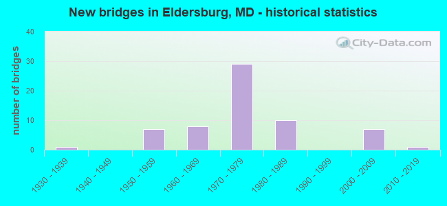
- New bridges - historical statistics
- 11930-1939
- 71950-1959
- 81960-1969
- 291970-1979
- 101980-1989
- 72000-2009
- 12010-2019
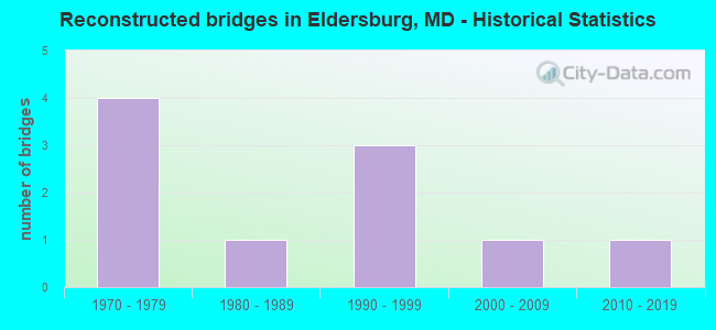
- Reconstructed bridges - Historical Statistics
- 41970-1979
- 11980-1989
- 31990-1999
- 12000-2009
- 12010-2019
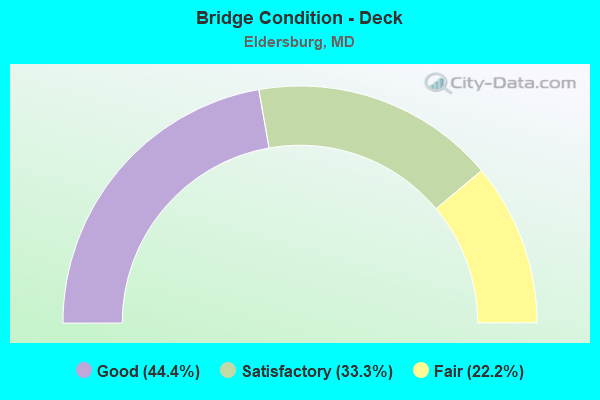
- Bridge Condition - Deck
- 44.4%Good
- 33.3%Satisfactory
- 22.2%Fair
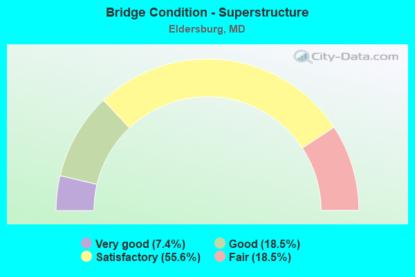
- Bridge Condition - Superstructure
- 7.4%Very good
- 18.5%Good
- 55.6%Satisfactory
- 18.5%Fair
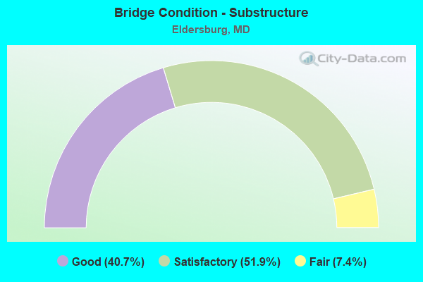
- Bridge Condition - Substructure
- 40.7%Good
- 51.9%Satisfactory
- 7.4%Fair
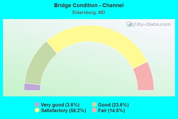
- Bridge Condition - Channel
- 3.6%Very good
- 23.6%Good
- 58.2%Satisfactory
- 14.5%Fair
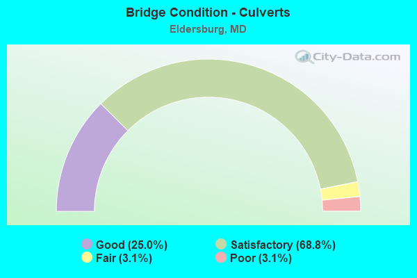
- Bridge Condition - Culverts
- 25.0%Good
- 68.8%Satisfactory
- 3.1%Fair
- 3.1%Poor
Find on map >> Show street view
Structure Number: 10000006000101, Location: 1.04 M W OF BALTO CO LINE (Lat: 39.395361, Lng: -76.907028), Route carried "on" structure: State highway 26, Year Built: 1954, Year Reconstructed: 1982, Status: Open, Structure Length: 30.02m (98.49ft), Average Daily Traffic: 20,192 (year 2009), Truck Traffic: 8%, Average Future Daily Traffic: 23,235 (year 2026), Design Load: HS 20, Features Intersected: LIBERTY RESERVOIR
Minimum Vertical Clearance: 30+ m (98+ ft), Kilometerpoint: 20.289, Lanes on structure: 2, Base Highway Network: Yes, Owner: State Highway Agency, Approaching Roadway Width: 13.4m (44.0ft), Material/Design: Steel, Design/Construction: Stringer/Multi-beam, Number Of Spans In Main Unit: 13, Length of Maximum Span: 22.6m (74.1ft), Curb-To-Curb Width: 11.0m (36.1ft), Out-to-Out Width: 11.9m (39.0ft)
Condition: Deck: Fair, Superstructure: Satisfactory, Substructure: Satisfactory, Channel: Very good, Operating Rating: 90.2 metric tons, Method Used To Determine Operating Rating: Load Factor (LF), Inventory Rating: 54.0 metric tons, Method Used To Determine Inventory Rating: Load Factor (LF), Structural Evaluation: Equal to present minimum criteria, Deck Geometry: Meets minimum limits, Waterway Adequacy: Superior to present desirable criteria, Approach Roadway Alignment: Equal to present desirable criteria, Length Of Structure Improvement: 30.02m (98.49ft), Designated Inspection Frequency: Every 24 months, Underwater Inspection Frequency: Every 48 months, Inspection Date: June 2021, Underwater Inspection Date: September 2021, Bridge Improvement Cost: $2,317,000, Roadway Improvement Cost: $232,000, Total Project Cost: $2,549,000, Deck Structure Type: Concrete Cast-file-Place, Wearing Surface/Protective System: Wearing Surface: Monolithic Concrete
Find on map >> Show street view
Structure Number: 10000006000201, Location: ON BALTO CO LINE (Lat: 39.396794, Lng: -76.889061), Route carried "on" structure: State highway 26, Year Built: 1954, Year Reconstructed: 1982, Status: Open, Structure Length: 52.40m (171.92ft), Average Daily Traffic: 20,192 (year 2009), Truck Traffic: 8%, Average Future Daily Traffic: 23,235 (year 2026), Design Load: HS 20, Features Intersected: LIBERTY RESERVOIR
Minimum Vertical Clearance: 30+ m (98+ ft), Kilometerpoint: 21.963, Lanes on structure: 2, Base Highway Network: Yes, Owner: State Highway Agency, Approaching Roadway Width: 13.4m (44.0ft), Material/Design: Steel, Design/Construction: Stringer/Multi-beam, Number Of Spans In Main Unit: 15, Length of Maximum Span: 44.2m (145.0ft), Curb-To-Curb Width: 11.0m (36.1ft), Out-to-Out Width: 11.9m (39.0ft)
Condition: Deck: Fair, Superstructure: Satisfactory, Substructure: Satisfactory, Channel: Good, Operating Rating: 69.8 metric tons, Method Used To Determine Operating Rating: Load Factor (LF), Inventory Rating: 41.7 metric tons, Method Used To Determine Inventory Rating: Load Factor (LF), Structural Evaluation: Equal to present minimum criteria, Deck Geometry: Meets minimum limits, Waterway Adequacy: Equal to present desirable criteria, Approach Roadway Alignment: Equal to present desirable criteria, Length Of Structure Improvement: 52.40m (171.92ft), Designated Inspection Frequency: Every 24 months, Underwater Inspection Frequency: Every 48 months, Inspection Date: June 2021, Underwater Inspection Date: September 2021, Bridge Improvement Cost: $4,043,000, Roadway Improvement Cost: $404,000, Total Project Cost: $4,447,000, Deck Structure Type: Concrete Cast-file-Place, Wearing Surface/Protective System: Wearing Surface: Monolithic Concrete
Find on map >> Show street view
Structure Number: 10000006001402, Location: 0.02 MILE NORTH OF MD 879 (Lat: 39.472336, Lng: -76.919958), Route carried "on" structure: State highway 91, Year Built: 1964, Status: Open, Structure Length: 0.76m (2.49ft), Average Daily Traffic: 10,670 (year 2009), Truck Traffic: 8%, Average Future Daily Traffic: 12,660 (year 2026), Design Load: HS 20, Features Intersected: MIDDLE RUN
Minimum Vertical Clearance: 30+ m (98+ ft), Kilometerpoint: 1.577, Lanes on structure: 2, Base Highway Network: Yes, Owner: State Highway Agency, Approaching Roadway Width: 13.4m (44.0ft), Material/Design: Concrete, Design/Construction: Culvert, Length of Maximum Span: 3.7m (12.1ft)
Condition: Channel: Fair, Culverts: Satisfactory, Operating Rating: 32.7 metric tons, Method Used To Determine Operating Rating: Field evaluation and documented engineering judgment, Inventory Rating: 32.7 metric tons, Method Used To Determine Inventory Rating: Field evaluation and documented engineering judgment, Structural Evaluation: Equal to present minimum criteria, Waterway Adequacy: Equal to present desirable criteria, Approach Roadway Alignment: Equal to present desirable criteria, Designated Inspection Frequency: Every 24 months, Inspection Date: Febuary 2021
Find on map >> Show street view
Structure Number: 10000006002801, Location: 1.02 M S OF BR NO 0306400 (Lat: 39.380942, Lng: -77.018744), Route carried "on" structure: State highway 97, Year Built: 1976, Status: Open, Structure Length: 2.01m (6.59ft), Average Daily Traffic: 8,770 (year 2009), Truck Traffic: 8%, Average Future Daily Traffic: 10,550 (year 2026), Design Load: HS 20, Features Intersected: TUCKERS BRANCH
Minimum Vertical Clearance: 30+ m (98+ ft), Kilometerpoint: 3.334, Lanes on structure: 2, Owner: State Highway Agency, Approaching Roadway Width: 13.4m (44.0ft), Material/Design: Steel, Design/Construction: Stringer/Multi-beam, Number Of Spans In Main Unit: 1, Length of Maximum Span: 18.9m (62.0ft), Curb-To-Curb Width: 13.4m (44.0ft), Out-to-Out Width: 14.4m (47.2ft)
Condition: Deck: Good, Superstructure: Good, Substructure: Good, Channel: Fair, Inventory Rating: 62.6 metric tons, Method Used To Determine Inventory Rating: Load Factor (LF), Structural Evaluation: Better than present minimum criteria, Deck Geometry: Equal to present minimum criteria, Waterway Adequacy: Equal to present desirable criteria, Approach Roadway Alignment: Equal to present desirable criteria, Designated Inspection Frequency: Every 24 months, Inspection Date: Febuary 2021, Deck Structure Type: Concrete Cast-file-Place, Wearing Surface/Protective System: Wearing Surface: Monolithic Concrete
Find on map >> Show street view
Structure Number: 10000006002901, Location: ON HOWARD CO LINE (Lat: 39.352392, Lng: -77.015781), Route carried "on" structure: State highway 97, Year Built: 1973, Status: Open, Structure Length: 3.47m (11.38ft), Average Daily Traffic: 8,770 (year 2009), Truck Traffic: 8%, Average Future Daily Traffic: 10,550 (year 2026), Design Load: HS 20, Features Intersected: SOUTH BRANCH PATAPSCO RI
Minimum Vertical Clearance: 30+ m (98+ ft), Kilometerpoint: 0.000, Lanes on structure: 2, Owner: State Highway Agency, Approaching Roadway Width: 8.5m (27.9ft), Skew: 1 degrees, Material/Design: Steel, Design/Construction: Stringer/Multi-beam, Number Of Spans In Main Unit: 2, Length of Maximum Span: 16.8m (55.1ft), Curb-To-Curb Width: 6.7m (22.0ft), Out-to-Out Width: 7.2m (23.6ft)
Condition: Deck: Satisfactory, Superstructure: Satisfactory, Substructure: Satisfactory, Channel: Satisfactory, Operating Rating: 61.2 metric tons, Method Used To Determine Operating Rating: Load Factor (LF), Inventory Rating: 36.7 metric tons, Method Used To Determine Inventory Rating: Load Factor (LF), Structural Evaluation: Equal to present minimum criteria, Deck Geometry: High priority of replacement, Waterway Adequacy: Equal to present desirable criteria, Approach Roadway Alignment: Equal to present minimum criteria, Length Of Structure Improvement: 3.47m (11.38ft), Designated Inspection Frequency: Every 24 months, Inspection Date: December 2020, Bridge Improvement Cost: $161,000, Roadway Improvement Cost: $16,000, Total Project Cost: $177,000, Deck Structure Type: Concrete Cast-file-Place, Wearing Surface/Protective System: Wearing Surface: Monolithic Concrete
Find on map >> Show street view
Structure Number: 10000006004303, Location: 3.63 MILE SOUTH OF MD 32 (Lat: 39.480503, Lng: -77.003814), Route carried "on" structure: State highway 854B, Year Built: 1983, Status: Open, Structure Length: 1.07m (3.51ft), Average Daily Traffic: 1,970 (year 2009), Truck Traffic: 8%, Average Future Daily Traffic: 2,502 (year 2026), Design Load: HS 20, Features Intersected: MORGAN RUN
Minimum Vertical Clearance: 30+ m (98+ ft), Kilometerpoint: 0.483, Lanes on structure: 2, Owner: State Highway Agency, Approaching Roadway Width: 5.5m (18.0ft), Material/Design: Steel, Design/Construction: Culvert, Length of Maximum Span: 3.0m (9.8ft)
Condition: Channel: Satisfactory, Culverts: Satisfactory, Operating Rating: 82.5 metric tons, Method Used To Determine Operating Rating: Load Factor (LF), Inventory Rating: 49.4 metric tons, Method Used To Determine Inventory Rating: Load Factor (LF), Structural Evaluation: Equal to present minimum criteria, Waterway Adequacy: Better than present minimum criteria, Approach Roadway Alignment: Equal to present minimum criteria, Designated Inspection Frequency: Every 24 months, Inspection Date: June 2021
Find on map >> Show street view
Structure Number: 10000006004502, Location: 1.0 MILE SOUTH OF MD 850H (Lat: 39.414889, Lng: -77.011942), Route carried "on" structure: State highway 97, Year Built: 1979, Status: Open, Structure Length: 1.55m (5.09ft), Average Daily Traffic: 10,080 (year 2009), Truck Traffic: 8%, Average Future Daily Traffic: 12,360 (year 2026), Design Load: HS 20, Features Intersected: PINEY RUN
Minimum Vertical Clearance: 30+ m (98+ ft), Kilometerpoint: 7.273, Lanes on structure: 2, Owner: State Highway Agency, Approaching Roadway Width: 13.4m (44.0ft), Skew: 2 degrees, Material/Design: Concrete, Design/Construction: Culvert, Length of Maximum Span: 4.9m (16.1ft), Curb-To-Curb Width: 13.4m (44.0ft), Out-to-Out Width: 14.0m (45.9ft)
Condition: Channel: Fair, Culverts: Satisfactory, Operating Rating: 32.7 metric tons, Method Used To Determine Operating Rating: Field evaluation and documented engineering judgment, Inventory Rating: 32.7 metric tons, Method Used To Determine Inventory Rating: Field evaluation and documented engineering judgment, Structural Evaluation: Equal to present minimum criteria, Deck Geometry: Equal to present minimum criteria, Waterway Adequacy: Equal to present desirable criteria, Approach Roadway Alignment: Equal to present desirable criteria, Designated Inspection Frequency: Every 24 months, Inspection Date: March 2021
Find on map >> Show street view
Structure Number: 10000006005001, Location: 3.14 MILE SOUTH OF MD 32 (Lat: 39.479036, Lng: -76.999631), Route carried "on" structure: State highway 97, Year Built: 1959, Year Reconstructed: 2009, Status: Open, Structure Length: 3.63m (11.91ft), Average Daily Traffic: 15,140 (year 2009), Truck Traffic: 8%, Average Future Daily Traffic: 20,840 (year 2029), Design Load: HS 20, Features Intersected: MORGAN RUN
Minimum Vertical Clearance: 30+ m (98+ ft), Kilometerpoint: 14.948, Lanes on structure: 2, Base Highway Network: Yes, Owner: State Highway Agency, Approaching Roadway Width: 13.4m (44.0ft), Material/Design: Steel, Design/Construction: Stringer/Multi-beam, Number Of Spans In Main Unit: 3, Length of Maximum Span: 18.0m (59.1ft), Curb or Sidewalk Widths: Left: 0.5m (1.6ft), Right: 0.5m (1.6ft), Curb-To-Curb Width: 12.3m (40.4ft), Out-to-Out Width: 13.3m (43.6ft)
Condition: Deck: Good, Superstructure: Satisfactory, Substructure: Fair, Channel: Satisfactory, Inventory Rating: 65.3 metric tons, Method Used To Determine Inventory Rating: Load Factor (LF), Structural Evaluation: Somewhat better than minimum adequacy, Deck Geometry: Somewhat better than minimum adequacy, Waterway Adequacy: Better than present minimum criteria, Approach Roadway Alignment: Equal to present desirable criteria, Designated Inspection Frequency: Every 24 months, Inspection Date: May 2020, Deck Structure Type: Concrete Cast-file-Place, Wearing Surface/Protective System: Wearing Surface: Monolithic Concrete, Deck Protection: Epoxy Coated Reinforcing
Find on map >> Show street view
Structure Number: 10000006005401, Location: 1.52 MILE EAST OF MD 26A (Lat: 39.431708, Lng: -77.006306), Route carried "on" structure: State highway 26, Year Built: 1962, Year Reconstructed: 2010, Status: Open, Structure Length: 3.63m (11.91ft), Average Daily Traffic: 25,970 (year 2009), Truck Traffic: 8%, Average Future Daily Traffic: 29,367 (year 2026), Design Load: HS 20, Features Intersected: MD 97
Minimum Vertical Clearance: 30+ m (98+ ft), Kilometerpoint: 10.426, Lanes on structure: 2, Lanes under structure: 2, Base Highway Network: Yes, Owner: State Highway Agency, Approaching Roadway Width: 10.1m (33.1ft), Skew: 1 degrees, Material/Design: Steel, Design/Construction: Stringer/Multi-beam, Number Of Spans In Main Unit: 2, Length of Maximum Span: 25.3m (83.0ft), Curb-To-Curb Width: 10.1m (33.1ft), Out-to-Out Width: 11.3m (37.1ft)
Condition: Deck: Good, Superstructure: Satisfactory, Substructure: Satisfactory, Inventory Rating: 63.0 metric tons, Method Used To Determine Inventory Rating: Load Factor (LF), Structural Evaluation: Equal to present minimum criteria, Deck Geometry: Meets minimum limits, Underclear: Equal to present minimum criteria, Approach Roadway Alignment: Equal to present desirable criteria, Length Of Structure Improvement: 3.60m (11.81ft), Designated Inspection Frequency: Every 24 months, Inspection Date: January 2021, Bridge Improvement Cost: $251,000, Roadway Improvement Cost: $25,000, Total Project Cost: $276,000, Deck Structure Type: Concrete Cast-file-Place, Wearing Surface/Protective System: Wearing Surface: Integral Concrete, Deck Protection: Epoxy Coated Reinforcing
Find on map >> Show street view
Structure Number: 10000006006002, Location: .21 MILE NORTH OF MD 879C (Lat: 39.486983, Lng: -76.900475), Route carried "on" structure: State highway 91, Year Built: 1967, Status: Open, Structure Length: 1.02m (3.35ft), Average Daily Traffic: 11,260 (year 2009), Truck Traffic: 8%, Average Future Daily Traffic: 11,840 (year 2029), Design Load: HS 20, Features Intersected: BEAVER RUN
Minimum Vertical Clearance: 30+ m (98+ ft), Kilometerpoint: 3.942, Lanes on structure: 2, Base Highway Network: Yes, Owner: State Highway Agency, Approaching Roadway Width: 13.4m (44.0ft), Skew: 1 degrees, Material/Design: Concrete, Design/Construction: Culvert, Length of Maximum Span: 4.9m (16.1ft)
Condition: Channel: Fair, Culverts: Satisfactory, Operating Rating: 32.7 metric tons, Method Used To Determine Operating Rating: Field evaluation and documented engineering judgment, Inventory Rating: 32.7 metric tons, Method Used To Determine Inventory Rating: Field evaluation and documented engineering judgment, Structural Evaluation: Equal to present minimum criteria, Waterway Adequacy: Better than present minimum criteria, Approach Roadway Alignment: Equal to present desirable criteria, Designated Inspection Frequency: Every 24 months, Inspection Date: April 2021
Find on map >> Show street view
Structure Number: 10000006006303, Location: 1.05 MI N OF BUSHEY RD (Lat: 39.440278, Lng: -77.000919), Route carried "on" structure: State highway 854A, Year Built: 1976, Status: Open, Structure Length: 1.52m (4.99ft), Average Daily Traffic: 647 (year 2006), Truck Traffic: 8%, Average Future Daily Traffic: 746 (year 2026), Design Load: HS 20, Features Intersected: LITTLE MORGAN RUN
Minimum Vertical Clearance: 30+ m (98+ ft), Kilometerpoint: 1.689, Lanes on structure: 2, Owner: State Highway Agency, Approaching Roadway Width: 9.1m (29.9ft), Material/Design: Steel, Design/Construction: Culvert, Length of Maximum Span: 3.0m (9.8ft)
Condition: Channel: Satisfactory, Culverts: Good, Structural Evaluation: Better than present minimum criteria, Waterway Adequacy: Equal to present desirable criteria, Approach Roadway Alignment: Equal to present desirable criteria, Designated Inspection Frequency: Every 24 months, Inspection Date: March 2021
Find on map >> Show street view
Structure Number: 10000006006402, Location: 2.42 MI S OF MD 850H (Lat: 39.395553, Lng: -77.017850), Route carried "on" structure: State highway 97, Year Built: 1982, Status: Open, Structure Length: 1.07m (3.51ft), Average Daily Traffic: 8,770 (year 2009), Truck Traffic: 8%, Average Future Daily Traffic: 10,550 (year 2026), Design Load: HS 20, Features Intersected: PINEY BRANCH
Minimum Vertical Clearance: 30+ m (98+ ft), Kilometerpoint: 4.843, Lanes on structure: 2, Owner: State Highway Agency, Approaching Roadway Width: 14.6m (47.9ft), Skew: 2 degrees, Material/Design: Concrete, Design/Construction: Culvert, Length of Maximum Span: 5.2m (17.1ft), Curb-To-Curb Width: 14.6m (47.9ft), Out-to-Out Width: 15.6m (51.2ft)
Condition: Channel: Satisfactory, Culverts: Satisfactory, Operating Rating: 32.7 metric tons, Method Used To Determine Operating Rating: Field evaluation and documented engineering judgment, Inventory Rating: 32.7 metric tons, Method Used To Determine Inventory Rating: Field evaluation and documented engineering judgment, Structural Evaluation: Equal to present minimum criteria, Deck Geometry: Superior to present desirable criteria, Waterway Adequacy: Equal to present desirable criteria, Approach Roadway Alignment: Equal to present desirable criteria, Designated Inspection Frequency: Every 24 months, Inspection Date: March 2021, Deck Structure Type: Concrete Cast-file-Place, Wearing Surface/Protective System: Wearing Surface: Bituminous
Find on map >> Show street view
Structure Number: 10000013001902, Location: 0.49 MILE S OF MD 851F (Lat: 39.348258, Lng: -76.960742), Route carried "on" structure: State highway 32, Year Built: 1958, Status: Open, Structure Length: 0.61m (2.00ft), Average Daily Traffic: 23,612 (year 2018), Truck Traffic: 8%, Average Future Daily Traffic: 23,657 (year 2038), Design Load: HS 20, Features Intersected: BR OF PATAPSCO RIVER
Minimum Vertical Clearance: 30+ m (98+ ft), Kilometerpoint: 36.138, Lanes on structure: 2, Base Highway Network: Yes, Owner: State Highway Agency, Approaching Roadway Width: 13.4m (44.0ft), Skew: 3 degrees, Material/Design: Concrete, Design/Construction: Culvert, Length of Maximum Span: 6.1m (20.0ft)
Condition: Channel: Good, Culverts: Satisfactory, Operating Rating: 32.7 metric tons, Method Used To Determine Operating Rating: Field evaluation and documented engineering judgment, Inventory Rating: 32.7 metric tons, Method Used To Determine Inventory Rating: Field evaluation and documented engineering judgment, Structural Evaluation: Equal to present minimum criteria, Waterway Adequacy: Equal to present desirable criteria, Approach Roadway Alignment: Equal to present desirable criteria, Designated Inspection Frequency: Every 24 months, Inspection Date: September 2021
Find on map >> Show street view
Structure Number: 100000130030013, Location: 3.17 MILES EAST OF MD 94 (Lat: 39.326756, Lng: -77.016875), Route carried "on" structure: Interstate 70, Year Built: 1973, Status: Open, Structure Length: 8.81m (28.90ft), Average Daily Traffic: 72,612 (year 2009), Truck Traffic: 8%, Average Future Daily Traffic: 112,212 (year 2029), Design Load: HS 20, Features Intersected: MD 97
Minimum Vertical Clearance: 30+ m (98+ ft), Kilometerpoint: 11.189, Lanes on structure: 3, Lanes under structure: 4, Base Highway Network: Yes, Owner: State Highway Agency, Approaching Roadway Width: 16.5m (54.1ft), Material/Design: Steel, Design/Construction: Stringer/Multi-beam, Number Of Spans In Main Unit: 2, Length of Maximum Span: 43.3m (142.1ft), Curb-To-Curb Width: 16.3m (53.5ft), Out-to-Out Width: 17.3m (56.8ft)
Condition: Deck: Satisfactory, Superstructure: Satisfactory, Substructure: Satisfactory, Operating Rating: 67.1 metric tons, Method Used To Determine Operating Rating: Load Factor (LF), Inventory Rating: 40.4 metric tons, Method Used To Determine Inventory Rating: Load Factor (LF), Structural Evaluation: Equal to present minimum criteria, Deck Geometry: Equal to present minimum criteria, Underclear: Superior to present desirable criteria, Approach Roadway Alignment: Equal to present desirable criteria, Designated Inspection Frequency: Every 24 months, Inspection Date: June 2021, Deck Structure Type: Concrete Cast-file-Place, Wearing Surface/Protective System: Wearing Surface: Latex Concrete
Find on map >> Show street view
Structure Number: 100000130030014, Location: 3.17 MILES EAST OF MD 94 (Lat: 39.326639, Lng: -77.015853), Route carried "on" structure: Interstate 70, Year Built: 1973, Status: Open, Structure Length: 8.81m (28.90ft), Average Daily Traffic: 72,612 (year 2009), Truck Traffic: 8%, Average Future Daily Traffic: 112,212 (year 2029), Design Load: HS 20, Features Intersected: MD 97
Minimum Vertical Clearance: 30+ m (98+ ft), Kilometerpoint: 11.189, Lanes on structure: 3, Lanes under structure: 4, Base Highway Network: Yes, Owner: State Highway Agency, Approaching Roadway Width: 16.5m (54.1ft), Material/Design: Steel, Design/Construction: Stringer/Multi-beam, Number Of Spans In Main Unit: 2, Length of Maximum Span: 43.3m (142.1ft), Curb-To-Curb Width: 16.3m (53.5ft), Out-to-Out Width: 17.3m (56.8ft)
Condition: Deck: Satisfactory, Superstructure: Fair, Substructure: Satisfactory, Operating Rating: 67.1 metric tons, Method Used To Determine Operating Rating: Load Factor (LF), Inventory Rating: 40.4 metric tons, Method Used To Determine Inventory Rating: Load Factor (LF), Structural Evaluation: Somewhat better than minimum adequacy, Deck Geometry: Equal to present minimum criteria, Underclear: Superior to present desirable criteria, Approach Roadway Alignment: Equal to present desirable criteria, Designated Inspection Frequency: Every 24 months, Inspection Date: June 2021, Deck Structure Type: Concrete Cast-file-Place, Wearing Surface/Protective System: Wearing Surface: Latex Concrete
Find on map >> Show street view
Structure Number: 10000013008201, Location: 1.89 MI W OF MD 97 (Lat: 39.336989, Lng: -77.048919), Route carried "on" structure: County highway 30, Year Built: 1973, Status: Open, Structure Length: 7.47m (24.51ft), Average Daily Traffic: 999 (year 1994), Truck Traffic: 5%, Average Future Daily Traffic: 1,178 (year 2012), Design Load: HS 20, Features Intersected: IS 70, Facility Carried by Structure: MORGAN STATION RD
Minimum Vertical Clearance: 30+ m (98+ ft), Kilometerpoint: 0.644, Lanes on structure: 2, Lanes under structure: 6, Owner: State Highway Agency, Approaching Roadway Width: 13.4m (44.0ft), Material/Design: Steel continuous, Design/Construction: Stringer/Multi-beam, Number Of Spans In Main Unit: 2, Length of Maximum Span: 36.6m (120.1ft), Curb-To-Curb Width: 13.4m (44.0ft), Out-to-Out Width: 14.4m (47.2ft)
Condition: Deck: Satisfactory, Superstructure: Satisfactory, Substructure: Satisfactory, Operating Rating: 73.0 metric tons, Method Used To Determine Operating Rating: Load Factor (LF), Inventory Rating: 43.5 metric tons, Method Used To Determine Inventory Rating: Load Factor (LF), Structural Evaluation: Equal to present minimum criteria, Deck Geometry: Superior to present desirable criteria, Underclear: Somewhat better than minimum adequacy, Approach Roadway Alignment: Equal to present desirable criteria, Designated Inspection Frequency: Every 24 months, Inspection Date: July 2020, Deck Structure Type: Concrete Cast-file-Place, Wearing Surface/Protective System: Wearing Surface: Monolithic Concrete
Find on map >> Show street view
Structure Number: 10000013011203, Location: 1.5 MILES WEST OF US 32 (Lat: 39.309503, Lng: -76.979081), Route carried "on" structure: State highway 144A, Year Built: 1982, Status: Open, Structure Length: 0.71m (2.33ft), Average Daily Traffic: 3,451 (year 2013), Truck Traffic: 8%, Average Future Daily Traffic: 4,278 (year 2026), Features Intersected: BR OF MIDDLE PATUXENT RI
Minimum Vertical Clearance: 30+ m (98+ ft), Kilometerpoint: 14.948, Lanes on structure: 2, Owner: State Highway Agency, Approaching Roadway Width: 8.2m (26.9ft), Skew: 2 degrees, Material/Design: Steel, Design/Construction: Culvert, Length of Maximum Span: 2.7m (8.9ft)
Condition: Channel: Satisfactory, Culverts: Satisfactory, Inventory Rating: 68.9 metric tons, Method Used To Determine Inventory Rating: Load Factor (LF), Structural Evaluation: Equal to present minimum criteria, Waterway Adequacy: Somewhat better than minimum adequacy, Approach Roadway Alignment: Equal to present desirable criteria, Designated Inspection Frequency: Every 24 months, Inspection Date: April 2020
Find on map >> Show street view
Structure Number: 200000B-005201, Location: AT BALT-CARROLL CO LINE (Lat: 39.364672, Lng: -76.885494), Route carried "on" structure: County highway 533, Year Built: 1976, Status: Open, Structure Length: 5.73m (18.80ft), Average Daily Traffic: 5,500 (year 2019), Truck Traffic: 5%, Average Future Daily Traffic: 6,500 (year 2039), Design Load: HS 20, Features Intersected: NORTH BRANCH OF PATAPSCO, Facility Carried by Structure: MARRIOTTSVILLE RD
Minimum Vertical Clearance: 30+ m (98+ ft), Kilometerpoint: 6.581, Lanes on structure: 2, Owner: County Highway Agency, Approaching Roadway Width: 11.6m (38.1ft), Skew: 4 degrees, Material/Design: Steel continuous, Design/Construction: Stringer/Multi-beam, Number Of Spans In Main Unit: 3, Length of Maximum Span: 21.6m (70.9ft), Curb-To-Curb Width: 11.0m (36.1ft), Out-to-Out Width: 11.9m (39.0ft)
Condition: Deck: Satisfactory, Superstructure: Fair, Substructure: Good, Channel: Good, Operating Rating: 66.7 metric tons, Method Used To Determine Operating Rating: Load Factor (LF), Inventory Rating: 39.9 metric tons, Method Used To Determine Inventory Rating: Load Factor (LF), Structural Evaluation: Somewhat better than minimum adequacy, Deck Geometry: Meets minimum limits, Waterway Adequacy: Better than present minimum criteria, Approach Roadway Alignment: Better than present minimum criteria, Designated Inspection Frequency: Every 24 months, Inspection Date: Febuary 2020, Deck Structure Type: Concrete Cast-file-Place, Wearing Surface/Protective System: Wearing Surface: Monolithic Concrete
Find on map >> Show street view
Structure Number: 200000B-021502, Location: 0.28 MI W OF W CHAPEL RD (Lat: 39.367697, Lng: -76.871397), Route carried "on" structure: County highway 533, Year Built: 1984, Status: Open, Structure Length: 1.13m (3.71ft), Average Daily Traffic: 4,050 (year 2017), Truck Traffic: 80%, Average Future Daily Traffic: 6,670 (year 2037), Design Load: HS 20, Features Intersected: FALLS RUN, Facility Carried by Structure: MARRIOTTSVILLE ROA
Minimum Vertical Clearance: 30+ m (98+ ft), Kilometerpoint: 5.905, Lanes on structure: 2, Owner: County Highway Agency, Approaching Roadway Width: 12.5m (41.0ft), Skew: 3 degrees, Material/Design: Concrete, Design/Construction: Culvert, Length of Maximum Span: 3.7m (12.1ft), Curb-To-Curb Width: 12.5m (41.0ft), Out-to-Out Width: 13.1m (43.0ft)
Condition: Channel: Good, Culverts: Satisfactory, Operating Rating: 60.8 metric tons, Method Used To Determine Operating Rating: Load Factor (LF), Inventory Rating: 36.3 metric tons, Method Used To Determine Inventory Rating: Load Factor (LF), Structural Evaluation: Equal to present minimum criteria, Deck Geometry: Equal to present minimum criteria, Waterway Adequacy: Equal to present minimum criteria, Approach Roadway Alignment: Equal to present minimum criteria, Designated Inspection Frequency: Every 24 months, Inspection Date: May 2021, Deck Structure Type: Concrete Cast-file-Place, Wearing Surface/Protective System: Wearing Surface: Monolithic Concrete
Find on map >> Show street view
Structure Number: 200000B-034302, Location: 0.57 MI N OF MD 26 (Lat: 39.404497, Lng: -76.860297), Route carried "on" structure: County highway 521, Year Built: 1969, Status: Posted for load, Structure Length: 0.76m (2.49ft), Average Daily Traffic: 7,003 (year 2021), Truck Traffic: 5%, Average Future Daily Traffic: 9,433 (year 2041), Design Load: HS 20, Features Intersected: LOCUST RUN, Facility Carried by Structure: WARDS CHAPEL ROAD
Minimum Vertical Clearance: 30+ m (98+ ft), Kilometerpoint: 2.671, Lanes on structure: 2, Owner: County Highway Agency, Approaching Roadway Width: 13.4m (44.0ft), Material/Design: Concrete, Design/Construction: Culvert, Length of Maximum Span: 3.7m (12.1ft)
Condition: Channel: Satisfactory, Culverts: Good, Operating Rating: 27.2 metric tons, Method Used To Determine Operating Rating: Load Factor (LF), Inventory Rating: 16.3 metric tons, Method Used To Determine Inventory Rating: Load Factor (LF), Structural Evaluation: Meets minimum limits, Waterway Adequacy: Better than present minimum criteria, Approach Roadway Alignment: Equal to present desirable criteria, Bridge Posting: Required (Relationship of Operating Rating to Maximum Legal Load: 20.0 - 29.9% below), Designated Inspection Frequency: Every 12 months, Inspection Date: June 2021
Find on map >> Show street view
Structure Number: 200000CL029702, Location: 2.51 MILES E OF MD 27 (Lat: 39.412258, Lng: -77.073847), Route carried "on" structure: County highway 570, Year Built: 1975, Status: Open, Structure Length: 1.86m (6.10ft), Average Daily Traffic: 828 (year 2021), Truck Traffic: 5%, Average Future Daily Traffic: 1,360 (year 2041), Features Intersected: GILLIS FALLS, Facility Carried by Structure: GILLIS ROAD
Minimum Vertical Clearance: 30+ m (98+ ft), Kilometerpoint: 4.039, Lanes on structure: 2, Owner: County Highway Agency, Approaching Roadway Width: 6.4m (21.0ft), Material/Design: Concrete, Design/Construction: Culvert, Length of Maximum Span: 4.3m (14.1ft), Curb-To-Curb Width: 6.2m (20.3ft), Out-to-Out Width: 10.5m (34.4ft)
Condition: Channel: Fair, Culverts: Satisfactory, Operating Rating: 44.9 metric tons, Method Used To Determine Operating Rating: Load Factor (LF), Inventory Rating: 26.8 metric tons, Method Used To Determine Inventory Rating: Load Factor (LF), Structural Evaluation: Equal to present minimum criteria, Deck Geometry: High priority of corrective action, Waterway Adequacy: Meets minimum limits, Approach Roadway Alignment: Equal to present minimum criteria, Length Of Structure Improvement: 1.83m (6.00ft), Designated Inspection Frequency: Every 24 months, Inspection Date: July 2021, Bridge Improvement Cost: $100,000, Roadway Improvement Cost: $20,000, Total Project Cost: $120,000
Find on map >> Show street view
Structure Number: 200000CL029802, Location: 0.93 MI EAST OF MD 27 (Lat: 39.472725, Lng: -77.053269), Route carried "on" structure: County highway 556, Year Built: 1974, Status: Open, Structure Length: 0.79m (2.59ft), Average Daily Traffic: 408 (year 2021), Truck Traffic: 8%, Average Future Daily Traffic: 670 (year 2041), Design Load: HS 20, Features Intersected: BRANCH OF MORGAN RUN, Facility Carried by Structure: BAKER ROAD
Minimum Vertical Clearance: 30+ m (98+ ft), Kilometerpoint: 1.319, Lanes on structure: 2, Owner: County Highway Agency, Approaching Roadway Width: 6.1m (20.0ft), Material/Design: Concrete, Design/Construction: Culvert, Length of Maximum Span: 3.7m (12.1ft), Curb-To-Curb Width: 7.3m (24.0ft), Out-to-Out Width: 7.9m (25.9ft)
Condition: Channel: Fair, Culverts: Satisfactory, Operating Rating: 44.9 metric tons, Method Used To Determine Operating Rating: Load Factor (LF), Inventory Rating: 26.8 metric tons, Method Used To Determine Inventory Rating: Load Factor (LF), Structural Evaluation: Equal to present minimum criteria, Deck Geometry: Meets minimum limits, Waterway Adequacy: Equal to present minimum criteria, Approach Roadway Alignment: Equal to present minimum criteria, Designated Inspection Frequency: Every 24 months, Inspection Date: June 2021
Find on map >> Show street view
Structure Number: 200000CL029902, Location: 0.26 MI SE OF BLOOM ROAD (Lat: 39.490439, Lng: -77.019636), Route carried "on" structure: County highway 555, Year Built: 1964, Status: Open, Structure Length: 1.40m (4.59ft), Average Daily Traffic: 982 (year 2021), Truck Traffic: 8%, Average Future Daily Traffic: 1,610 (year 2041), Design Load: H 15, Features Intersected: MORGAN RUN, Facility Carried by Structure: SALEM BOTTOM ROAD
Minimum Vertical Clearance: 30+ m (98+ ft), Kilometerpoint: 2.928, Lanes on structure: 2, Owner: County Highway Agency, Approaching Roadway Width: 7.3m (24.0ft), Skew: 4 degrees, Material/Design: Concrete, Design/Construction: Culvert, Length of Maximum Span: 4.9m (16.1ft), Curb-To-Curb Width: 10.0m (32.8ft), Out-to-Out Width: 10.6m (34.8ft)
Condition: Channel: Fair, Culverts: Satisfactory, Operating Rating: 43.5 metric tons, Method Used To Determine Operating Rating: Load Factor (LF), Inventory Rating: 25.8 metric tons, Method Used To Determine Inventory Rating: Load Factor (LF), Structural Evaluation: Equal to present minimum criteria, Deck Geometry: Equal to present minimum criteria, Waterway Adequacy: Equal to present desirable criteria, Approach Roadway Alignment: Equal to present minimum criteria, Length Of Structure Improvement: 1.52m (4.99ft), Designated Inspection Frequency: Every 24 months, Inspection Date: June 2021, Bridge Improvement Cost: $250,000, Roadway Improvement Cost: $25,000, Total Project Cost: $275,000 ( Estimate for 2017)
Find on map >> Show street view
Structure Number: 200000CL030002, Location: 250 FT S OF SALEM BOTTOM (Lat: 39.493136, Lng: -77.022767), Route carried "on" structure: County highway 559, Year Built: 1980, Status: Open, Structure Length: 1.30m (4.27ft), Average Daily Traffic: 520 (year 2021), Truck Traffic: 8%, Average Future Daily Traffic: 860 (year 2041), Design Load: HS 20, Features Intersected: MORGAN RUN, Facility Carried by Structure: BLOOM ROAD
Minimum Vertical Clearance: 30+ m (98+ ft), Kilometerpoint: 0.080, Lanes on structure: 2, Owner: County Highway Agency, Approaching Roadway Width: 6.7m (22.0ft), Material/Design: Concrete, Design/Construction: Culvert, Length of Maximum Span: 4.3m (14.1ft), Curb-To-Curb Width: 10.5m (34.4ft), Out-to-Out Width: 11.5m (37.7ft)
Condition: Channel: Satisfactory, Culverts: Satisfactory, Operating Rating: 33.1 metric tons, Method Used To Determine Operating Rating: Load Factor (LF), Inventory Rating: 19.5 metric tons, Method Used To Determine Inventory Rating: Load Factor (LF), Structural Evaluation: Somewhat better than minimum adequacy, Deck Geometry: Equal to present minimum criteria, Waterway Adequacy: Equal to present desirable criteria, Approach Roadway Alignment: Equal to present desirable criteria, Designated Inspection Frequency: Every 24 months, Inspection Date: June 2021
Find on map >> Show street view
Structure Number: 200000CL030902, Location: ON HOWARD CO LINE (Lat: 39.362436, Lng: -77.066208), Route carried "on" structure: County highway 599, Year Built: 1988, Status: Open, Structure Length: 1.31m (4.30ft), Average Daily Traffic: 747 (year 2021), Truck Traffic: 5%, Average Future Daily Traffic: 1,225 (year 2041), Features Intersected: SOUTH BR PATAPSCO RIVER, Facility Carried by Structure: FLAG MARSH ROAD
Minimum Vertical Clearance: 30+ m (98+ ft), Kilometerpoint: 0.000, Lanes on structure: 2, Owner: County Highway Agency, Approaching Roadway Width: 6.7m (22.0ft), Skew: 3 degrees, Material/Design: Concrete, Design/Construction: Culvert, Length of Maximum Span: 6.4m (21.0ft), Curb-To-Curb Width: 11.2m (36.7ft), Out-to-Out Width: 11.8m (38.7ft)
Condition: Channel: Satisfactory, Culverts: Satisfactory, Structural Evaluation: Equal to present minimum criteria, Deck Geometry: Better than present minimum criteria, Waterway Adequacy: Better than present minimum criteria, Approach Roadway Alignment: Equal to present minimum criteria, Designated Inspection Frequency: Every 24 months, Inspection Date: July 2021
Find on map >> Show street view
Structure Number: 200000CL031001, Location: ON HOWARD CO LINE (Lat: 39.359917, Lng: -77.062728), Route carried "on" structure: County highway 565, Year Built: 1976, Status: Open, Structure Length: 3.47m (11.38ft), Average Daily Traffic: 8,182 (year 2021), Truck Traffic: 5%, Average Future Daily Traffic: 13,408 (year 2041), Design Load: HS 20, Features Intersected: SOUTH BRANCH PATAPSCO RI, Facility Carried by Structure: WOODBINE ROAD
Minimum Vertical Clearance: 30+ m (98+ ft), Kilometerpoint: 10.121, Lanes on structure: 2, Owner: County Highway Agency, Approaching Roadway Width: 11.6m (38.1ft), Skew: 1 degrees, Material/Design: Steel, Design/Construction: Stringer/Multi-beam, Number Of Spans In Main Unit: 2, Length of Maximum Span: 16.8m (55.1ft), Curb-To-Curb Width: 12.2m (40.0ft), Out-to-Out Width: 13.3m (43.6ft)
Condition: Deck: Fair, Superstructure: Satisfactory, Substructure: Satisfactory, Channel: Good, Operating Rating: 88.0 metric tons, Method Used To Determine Operating Rating: Load Factor (LF), Inventory Rating: 52.6 metric tons, Method Used To Determine Inventory Rating: Load Factor (LF), Structural Evaluation: Equal to present minimum criteria, Deck Geometry: Somewhat better than minimum adequacy, Waterway Adequacy: Better than present minimum criteria, Approach Roadway Alignment: Equal to present desirable criteria, Designated Inspection Frequency: Every 24 months, Inspection Date: July 2021, Deck Structure Type: Concrete Cast-file-Place
Find on map >> Show street view
Structure Number: 200000CL031101, Location: ON HOWARD COUNTY LINE (Lat: 39.359964, Lng: -77.045650), Route carried "on" structure: County highway 602, Year Built: 1976, Status: Open, Structure Length: 3.09m (10.14ft), Average Daily Traffic: 470 (year 2021), Truck Traffic: 8%, Average Future Daily Traffic: 769 (year 2041), Design Load: HS 20, Features Intersected: SOUTH BRANCH PATAPSCO RI, Facility Carried by Structure: MORGAN ROAD
Minimum Vertical Clearance: 30+ m (98+ ft), Kilometerpoint: 2.333, Lanes on structure: 2, Owner: County Highway Agency, Approaching Roadway Width: 7.0m (23.0ft), Skew: 4 degrees, Material/Design: Steel, Design/Construction: Stringer/Multi-beam, Number Of Spans In Main Unit: 1, Length of Maximum Span: 29.0m (95.1ft), Curb-To-Curb Width: 9.8m (32.2ft), Out-to-Out Width: 10.7m (35.1ft)
Condition: Deck: Satisfactory, Superstructure: Satisfactory, Substructure: Satisfactory, Channel: Good, Inventory Rating: 71.2 metric tons, Method Used To Determine Inventory Rating: Load Factor (LF), Structural Evaluation: Equal to present minimum criteria, Deck Geometry: Equal to present minimum criteria, Waterway Adequacy: Better than present minimum criteria, Approach Roadway Alignment: Equal to present minimum criteria, Designated Inspection Frequency: Every 24 months, Inspection Date: July 2021, Deck Structure Type: Concrete Cast-file-Place, Wearing Surface/Protective System: Wearing Surface: Monolithic Concrete
Find on map >> Show street view
Structure Number: 200000CL031203, Location: 0.1 MI N HOWARD CO LINE (Lat: 39.361481, Lng: -76.992853), Route carried "on" structure: County highway 673, Year Built: 1989, Status: Open, Structure Length: 0.61m (2.00ft), Average Daily Traffic: 1,282 (year 2021), Truck Traffic: 8%, Average Future Daily Traffic: 2,110 (year 2041), Design Load: HS 20, Features Intersected: UNNAMED STREAM, Facility Carried by Structure: GAITHER ROAD
Minimum Vertical Clearance: 30+ m (98+ ft), Kilometerpoint: 0.000, Lanes on structure: 2, Owner: County Highway Agency, Approaching Roadway Width: 6.1m (20.0ft), Skew: 2 degrees, Material/Design: Steel, Design/Construction: Culvert, Length of Maximum Span: 2.4m (7.9ft)
Condition: Channel: Satisfactory, Culverts: Satisfactory, Structural Evaluation: Equal to present minimum criteria, Waterway Adequacy: Better than present minimum criteria, Approach Roadway Alignment: Equal to present desirable criteria, Length Of Structure Improvement: 0.61m (2.00ft), Designated Inspection Frequency: Every 24 months, Inspection Date: August 2021, Bridge Improvement Cost: $20,000, Roadway Improvement Cost: $2,000, Total Project Cost: $22,000
Find on map >> Show street view
Structure Number: 200000CL031301, Location: ON HOWARD COUNTY LINE (Lat: 39.359781, Lng: -76.992108), Route carried "on" structure: County highway 673, Year Built: 1978, Status: Open, Structure Length: 1.86m (6.10ft), Average Daily Traffic: 1,282 (year 2021), Truck Traffic: 8%, Average Future Daily Traffic: 2,110 (year 2041), Features Intersected: SOUTH BRANCH PATAPSCO RI, Facility Carried by Structure: GAITHER ROAD
Minimum Vertical Clearance: 30+ m (98+ ft), Kilometerpoint: 2.478, Lanes on structure: 2, Owner: County Highway Agency, Approaching Roadway Width: 6.7m (22.0ft), Material/Design: Steel, Design/Construction: Truss - Thru, Number Of Spans In Main Unit: 1, Length of Maximum Span: 18.6m (61.0ft), Curb-To-Curb Width: 7.2m (23.6ft), Out-to-Out Width: 8.2m (26.9ft)
Condition: Deck: Satisfactory, Superstructure: Satisfactory, Substructure: Good, Channel: Satisfactory, Operating Rating: 39.0 metric tons, Method Used To Determine Operating Rating: Load Factor (LF), Inventory Rating: 23.1 metric tons, Method Used To Determine Inventory Rating: Load Factor (LF), Structural Evaluation: Equal to present minimum criteria, Deck Geometry: High priority of corrective action, Waterway Adequacy: Better than present minimum criteria, Approach Roadway Alignment: Equal to present minimum criteria, Length Of Structure Improvement: 4.91m (16.11ft), Designated Inspection Frequency: Every 24 months, Critical Feature Inspection Frequency: Every 24 months, Inspection Date: July 2021, Critical Feature Inspection Date: July 2021, Bridge Improvement Cost: $300,000, Roadway Improvement Cost: $30,000, Total Project Cost: $330,000, Deck Structure Type: Steel plate
Find on map >> Show street view
Structure Number: 200000CL031602, Location: 0.27 MI WEST OF MD 97 (Lat: 39.385078, Lng: -77.024064), Route carried "on" structure: County highway 604, Year Built: 1969, Status: Open, Structure Length: 0.98m (3.22ft), Average Daily Traffic: 1,535 (year 2021), Truck Traffic: 8%, Average Future Daily Traffic: 2,520 (year 2041), Features Intersected: TUCKERS BRANCH, Facility Carried by Structure: EDEN MILL ROAD
Minimum Vertical Clearance: 30+ m (98+ ft), Kilometerpoint: 0.434, Lanes on structure: 2, Owner: County Highway Agency, Approaching Roadway Width: 6.7m (22.0ft), Skew: 3 degrees, Material/Design: Concrete, Design/Construction: Culvert, Length of Maximum Span: 4.3m (14.1ft), Curb-To-Curb Width: 12.5m (41.0ft), Out-to-Out Width: 13.1m (43.0ft)
Condition: Channel: Satisfactory, Culverts: Satisfactory, Operating Rating: 71.2 metric tons, Method Used To Determine Operating Rating: Load Factor (LF), Inventory Rating: 42.6 metric tons, Method Used To Determine Inventory Rating: Load Factor (LF), Structural Evaluation: Equal to present minimum criteria, Deck Geometry: Better than present minimum criteria, Waterway Adequacy: Better than present minimum criteria, Approach Roadway Alignment: Equal to present desirable criteria, Designated Inspection Frequency: Every 24 months, Inspection Date: August 2021
Find on map >> Show street view
Structure Number: 200000CL031802, Location: 1.07 MILES S OF MD 26 (Lat: 39.404286, Lng: -76.997456), Route carried "on" structure: County highway 664, Year Built: 2017, Status: Open, Structure Length: 1.22m (4.00ft), Average Daily Traffic: 4,226 (year 2021), Truck Traffic: 5%, Average Future Daily Traffic: 6,760 (year 2041), Features Intersected: PINEY RUN, Facility Carried by Structure: WHITE ROCK ROAD
Minimum Vertical Clearance: 30+ m (98+ ft), Kilometerpoint: 1.722, Lanes on structure: 2, Owner: County Highway Agency, Approaching Roadway Width: 7.3m (24.0ft), Skew: 1 degrees, Material/Design: Concrete, Design/Construction: Culvert, Length of Maximum Span: 3.7m (12.1ft), Curb-To-Curb Width: 10.8m (35.4ft), Out-to-Out Width: 11.7m (38.4ft)
Condition: Channel: Very good, Culverts: Good, Operating Rating: 61.9 metric tons, Method Used To Determine Operating Rating: Load and Resistance Factor Rating (LRFR) rating reported by rating factor(RF) method using HL-93 loadings, Inventory Rating: 48.0 metric tons, Method Used To Determine Inventory Rating: Load and Resistance Factor Rating (LRFR) rating reported by rating factor(RF) method using HL-93 loadings, Structural Evaluation: Better than present minimum criteria, Deck Geometry: Somewhat better than minimum adequacy, Waterway Adequacy: Equal to present desirable criteria, Approach Roadway Alignment: Equal to present desirable criteria, Designated Inspection Frequency: Every 24 months, Inspection Date: July 2021
Find on map >> Show street view
Structure Number: 200000CL031901, Location: 0.75 MI E OF FRETER ROAD (Lat: 39.421381, Lng: -77.027892), Route carried "on" structure: County highway 616, Year Built: 1952, Year Reconstructed: 1984, Status: Open, Structure Length: 0.98m (3.22ft), Average Daily Traffic: 694 (year 2021), Truck Traffic: 8%, Average Future Daily Traffic: 1,136 (year 2041), Design Load: H 20, Features Intersected: BUCKHORN RUN, Facility Carried by Structure: BUCKHORN ROAD
Minimum Vertical Clearance: 30+ m (98+ ft), Kilometerpoint: 2.928, Lanes on structure: 2, Owner: County Highway Agency, Approaching Roadway Width: 6.4m (21.0ft), Skew: 2 degrees, Material/Design: Steel, Design/Construction: Stringer/Multi-beam, Number Of Spans In Main Unit: 1, Length of Maximum Span: 7.9m (25.9ft), Curb-To-Curb Width: 6.1m (20.0ft), Out-to-Out Width: 6.6m (21.7ft)
Condition: Deck: Good, Superstructure: Good, Substructure: Satisfactory, Channel: Satisfactory, Operating Rating: 78.9 metric tons, Method Used To Determine Operating Rating: Load Factor (LF), Inventory Rating: 47.2 metric tons, Method Used To Determine Inventory Rating: Load Factor (LF), Structural Evaluation: Equal to present minimum criteria, Deck Geometry: High priority of corrective action, Waterway Adequacy: Equal to present desirable criteria, Approach Roadway Alignment: Equal to present minimum criteria, Designated Inspection Frequency: Every 24 months, Inspection Date: September 2021, Deck Structure Type: Concrete Cast-file-Place
Find on map >> Show street view
Structure Number: 200000CL032002, Location: 0.40 MI SOUTH OF MD 26 (Lat: 39.433200, Lng: -77.028992), Route carried "on" structure: County highway 617, Year Built: 2004, Status: Open, Structure Length: 0.61m (2.00ft), Average Daily Traffic: 806 (year 2021), Truck Traffic: 7%, Average Future Daily Traffic: 1,330 (year 2041), Design Load: HS 25 or greater, Features Intersected: PINEY RUN, Facility Carried by Structure: FRETER ROAD
Minimum Vertical Clearance: 30+ m (98+ ft), Kilometerpoint: 0.644, Lanes on structure: 2, Owner: County Highway Agency, Approaching Roadway Width: 6.1m (20.0ft), Material/Design: Concrete, Design/Construction: Culvert, Length of Maximum Span: 6.1m (20.0ft), Curb or Sidewalk Widths: Left: 0.4m (1.3ft), Right: 0.4m (1.3ft), Curb-To-Curb Width: 7.9m (25.9ft), Out-to-Out Width: 8.7m (28.5ft)
Condition: Channel: Good, Culverts: Good, Structural Evaluation: Better than present minimum criteria, Deck Geometry: Somewhat better than minimum adequacy, Waterway Adequacy: Better than present minimum criteria, Approach Roadway Alignment: Equal to present desirable criteria, Designated Inspection Frequency: Every 24 months, Inspection Date: June 2021
Find on map >> Show street view
Structure Number: 200000CL032201, Location: 1.25 MILES N OF MD 26 (Lat: 39.430900, Lng: -76.975281), Route carried "on" structure: County highway 663, Year Built: 1980, Status: Open, Structure Length: 1.40m (4.59ft), Average Daily Traffic: 867 (year 2021), Truck Traffic: 8%, Average Future Daily Traffic: 1,421 (year 2041), Design Load: H 20, Features Intersected: LITTLE MORGAN RUN, Facility Carried by Structure: LINTON ROAD
Minimum Vertical Clearance: 30+ m (98+ ft), Kilometerpoint: 0.579, Lanes on structure: 2, Owner: County Highway Agency, Approaching Roadway Width: 6.1m (20.0ft), Material/Design: Steel, Design/Construction: Stringer/Multi-beam, Number Of Spans In Main Unit: 1, Length of Maximum Span: 12.8m (42.0ft), Curb-To-Curb Width: 6.1m (20.0ft), Out-to-Out Width: 6.6m (21.7ft)
Condition: Deck: Fair, Superstructure: Fair, Substructure: Good, Channel: Satisfactory, Operating Rating: 47.6 metric tons, Method Used To Determine Operating Rating: Load Factor (LF), Inventory Rating: 28.6 metric tons, Method Used To Determine Inventory Rating: Load Factor (LF), Structural Evaluation: Somewhat better than minimum adequacy, Deck Geometry: High priority of corrective action, Waterway Adequacy: Equal to present minimum criteria, Approach Roadway Alignment: Equal to present minimum criteria, Length Of Structure Improvement: 4.57m (14.99ft), Designated Inspection Frequency: Every 24 months, Inspection Date: September 2021, Bridge Improvement Cost: $280,000, Roadway Improvement Cost: $20,000, Total Project Cost: $300,000, Deck Structure Type: Closed Grating, Wearing Surface/Protective System: Wearing Surface: Integral Concrete
Find on map >> Show street view
Structure Number: 200000CL032301, Location: 1.7 M S OF MD 32 (Lat: 39.452131, Lng: -76.955219), Route carried "on" structure: County highway 544, Year Built: 1956, Year Reconstructed: 1989, Status: Open, Structure Length: 1.92m (6.30ft), Average Daily Traffic: 787 (year 2021), Truck Traffic: 8%, Average Future Daily Traffic: 1,290 (year 2041), Design Load: H 20, Features Intersected: MORGAN RUN, Facility Carried by Structure: LONDON BRIDGE ROAD
Minimum Vertical Clearance: 30+ m (98+ ft), Kilometerpoint: 2.687, Lanes on structure: 2, Owner: County Highway Agency, Approaching Roadway Width: 6.7m (22.0ft), Material/Design: Steel, Design/Construction: Stringer/Multi-beam, Number Of Spans In Main Unit: 1, Length of Maximum Span: 18.0m (59.1ft), Curb-To-Curb Width: 7.4m (24.3ft), Out-to-Out Width: 7.8m (25.6ft)
Condition: Deck: Good, Superstructure: Satisfactory, Substructure: Satisfactory, Channel: Satisfactory, Inventory Rating: 59.4 metric tons, Method Used To Determine Inventory Rating: Load Factor (LF), Structural Evaluation: Equal to present minimum criteria, Deck Geometry: Meets minimum limits, Waterway Adequacy: Equal to present desirable criteria, Approach Roadway Alignment: Equal to present minimum criteria, Designated Inspection Frequency: Every 24 months, Inspection Date: July 2021, Deck Structure Type: Concrete Cast-file-Place, Wearing Surface/Protective System: Wearing Surface: Integral Concrete
Find on map >> Show street view
Structure Number: 200000CL032401, Location: 1.25 M W OF MD 32 (Lat: 39.466342, Lng: -76.970625), Route carried "on" structure: County highway 545, Year Built: 1988, Status: Open, Structure Length: 1.93m (6.33ft), Average Daily Traffic: 1,754 (year 2021), Truck Traffic: 8%, Average Future Daily Traffic: 2,880 (year 2041), Design Load: H 20, Features Intersected: MORGAN RUN, Facility Carried by Structure: KLEES MILL ROAD
Minimum Vertical Clearance: 30+ m (98+ ft), Kilometerpoint: 2.108, Lanes on structure: 2, Owner: County Highway Agency, Approaching Roadway Width: 7.0m (23.0ft), Material/Design: Steel, Design/Construction: Stringer/Multi-beam, Number Of Spans In Main Unit: 1, Length of Maximum Span: 18.3m (60.0ft), Curb-To-Curb Width: 7.4m (24.3ft), Out-to-Out Width: 7.8m (25.6ft)
Condition: Deck: Good, Superstructure: Satisfactory, Substructure: Satisfactory, Channel: Good, Inventory Rating: 59.0 metric tons, Method Used To Determine Inventory Rating: Load Factor (LF), Structural Evaluation: Equal to present minimum criteria, Deck Geometry: Meets minimum limits, Waterway Adequacy: Equal to present minimum criteria, Approach Roadway Alignment: Equal to present minimum criteria, Designated Inspection Frequency: Every 24 months, Inspection Date: August 2021, Deck Structure Type: Concrete Cast-file-Place, Wearing Surface/Protective System: Deck Protection: Epoxy Coated Reinforcing
Find on map >> Show street view
Structure Number: 200000CL032602, Location: 1.73 MILES N OF MD 32 (Lat: 39.426656, Lng: -76.960519), Route carried "on" structure: County highway 662, Year Built: 1968, Status: Open, Structure Length: 1.22m (4.00ft), Average Daily Traffic: 4,061 (year 2021), Truck Traffic: 8%, Average Future Daily Traffic: 6,993 (year 2043), Features Intersected: LITTLE MORGAN RUN, Facility Carried by Structure: BARTHOLOW ROAD
Minimum Vertical Clearance: 30+ m (98+ ft), Kilometerpoint: 2.784, Lanes on structure: 2, Owner: County Highway Agency, Approaching Roadway Width: 6.7m (22.0ft), Material/Design: Concrete, Design/Construction: Culvert, Length of Maximum Span: 3.7m (12.1ft), Curb-To-Curb Width: 12.3m (40.4ft), Out-to-Out Width: 12.9m (42.3ft)
Condition: Channel: Fair, Culverts: Satisfactory, Operating Rating: 57.1 metric tons, Method Used To Determine Operating Rating: Load Factor (LF), Inventory Rating: 34.0 metric tons, Method Used To Determine Inventory Rating: Load Factor (LF), Structural Evaluation: Equal to present minimum criteria, Deck Geometry: Equal to present minimum criteria, Waterway Adequacy: Equal to present minimum criteria, Approach Roadway Alignment: Equal to present desirable criteria, Designated Inspection Frequency: Every 24 months, Inspection Date: August 2021
Find on map >> Show street view
Structure Number: 200000CL032702, Location: 1.06 MI N RAINCLIFFE ROAD (Lat: 39.384350, Lng: -76.945067), Route carried "on" structure: County highway 755, Year Built: 1975, Status: Open, Structure Length: 1.10m (3.61ft), Average Daily Traffic: 905 (year 2021), Truck Traffic: 8%, Average Future Daily Traffic: 1,490 (year 2041), Features Intersected: TRIBUTARY OF PINEY RUN, Facility Carried by Structure: SLACKS ROAD
Minimum Vertical Clearance: 30+ m (98+ ft), Kilometerpoint: 1.706, Lanes on structure: 2, Owner: County Highway Agency, Approaching Roadway Width: 6.4m (21.0ft), Material/Design: Concrete, Design/Construction: Culvert, Length of Maximum Span: 3.4m (11.2ft), Curb-To-Curb Width: 7.3m (24.0ft), Out-to-Out Width: 8.0m (26.2ft)
Condition: Channel: Satisfactory, Culverts: Satisfactory, Operating Rating: 29.5 metric tons, Method Used To Determine Operating Rating: Load Factor (LF), Inventory Rating: 17.7 metric tons, Method Used To Determine Inventory Rating: Load Factor (LF), Structural Evaluation: Meets minimum limits, Deck Geometry: Meets minimum limits, Waterway Adequacy: Equal to present minimum criteria, Approach Roadway Alignment: Equal to present minimum criteria, Length Of Structure Improvement: 4.27m (14.01ft), Designated Inspection Frequency: Every 24 months, Inspection Date: July 2021, Bridge Improvement Cost: $150,000, Roadway Improvement Cost: $20,000, Total Project Cost: $170,000
Find on map >> Show street view
Structure Number: 200000CL032801, Location: 0.80 MI N RAINCLIFFE ROAD (Lat: 39.380697, Lng: -76.944200), Route carried "on" structure: County highway 755, Year Built: 1975, Status: Open, Structure Length: 2.29m (7.51ft), Average Daily Traffic: 905 (year 2021), Truck Traffic: 5%, Average Future Daily Traffic: 1,490 (year 2041), Features Intersected: PINEY RUN, Facility Carried by Structure: SLACKS ROAD
Minimum Vertical Clearance: 30+ m (98+ ft), Kilometerpoint: 2.140, Lanes on structure: 2, Owner: County Highway Agency, Approaching Roadway Width: 5.8m (19.0ft), Material/Design: Steel, Design/Construction: Stringer/Multi-beam, Number Of Spans In Main Unit: 1, Length of Maximum Span: 21.9m (71.9ft), Curb-To-Curb Width: 7.3m (24.0ft), Out-to-Out Width: 8.3m (27.2ft)
Condition: Deck: Good, Superstructure: Satisfactory, Substructure: Satisfactory, Channel: Satisfactory, Inventory Rating: 56.7 metric tons, Method Used To Determine Inventory Rating: Load Factor (LF), Structural Evaluation: Equal to present minimum criteria, Deck Geometry: Meets minimum limits, Waterway Adequacy: Better than present minimum criteria, Approach Roadway Alignment: Equal to present desirable criteria, Designated Inspection Frequency: Every 24 months, Inspection Date: July 2021, Deck Structure Type: Concrete Cast-file-Place
Find on map >> Show street view
Structure Number: 200000CL032901, Location: 0.55 MI E OF ARRINGTON RD (Lat: 39.374503, Lng: -76.931217), Route carried "on" structure: County highway 761, Year Built: 1974, Status: Open, Structure Length: 2.56m (8.40ft), Average Daily Traffic: 3,125 (year 2021), Truck Traffic: 8%, Average Future Daily Traffic: 5,130 (year 2041), Features Intersected: PINEY RUN, Facility Carried by Structure: BRANGELS ROAD
Minimum Vertical Clearance: 30+ m (98+ ft), Kilometerpoint: 1.384, Lanes on structure: 2, Owner: County Highway Agency, Approaching Roadway Width: 6.7m (22.0ft), Material/Design: Steel, Design/Construction: Stringer/Multi-beam, Number Of Spans In Main Unit: 1, Length of Maximum Span: 24.4m (80.1ft), Curb-To-Curb Width: 9.8m (32.2ft), Out-to-Out Width: 10.7m (35.1ft)
Condition: Deck: Satisfactory, Superstructure: Good, Substructure: Good, Channel: Satisfactory, Operating Rating: 81.2 metric tons, Method Used To Determine Operating Rating: Load Factor (LF), Inventory Rating: 48.5 metric tons, Method Used To Determine Inventory Rating: Load Factor (LF), Structural Evaluation: Better than present minimum criteria, Deck Geometry: Meets minimum limits, Waterway Adequacy: Better than present minimum criteria, Approach Roadway Alignment: Equal to present desirable criteria, Designated Inspection Frequency: Every 24 months, Inspection Date: July 2021, Deck Structure Type: Concrete Cast-file-Place, Wearing Surface/Protective System: Wearing Surface: Monolithic Concrete
Find on map >> Show street view
Structure Number: 200000CL033101, Location: AT MARRIOTTSVILLE ROAD (Lat: 39.366303, Lng: -76.911503), Route carried "on" structure: County highway 758, Year Built: 1958, Year Reconstructed: 1999, Status: Open, Structure Length: 1.49m (4.89ft), Average Daily Traffic: 260 (year 2021), Truck Traffic: 8%, Average Future Daily Traffic: 430 (year 2041), Features Intersected: PINEY RUN, Facility Carried by Structure: ARRINGTON ROAD
Minimum Vertical Clearance: 30+ m (98+ ft), Kilometerpoint: 0.016, Lanes on structure: 2, Owner: County Highway Agency, Approaching Roadway Width: 8.2m (26.9ft), Material/Design: Prestressed concrete, Design/Construction: Slab, Number Of Spans In Main Unit: 1, Length of Maximum Span: 14.6m (47.9ft), Curb-To-Curb Width: 7.9m (25.9ft), Out-to-Out Width: 8.6m (28.2ft)
Condition: Deck: Good, Superstructure: Very good, Substructure: Good, Channel: Good, Operating Rating: 60.3 metric tons, Method Used To Determine Operating Rating: Load Factor (LF), Inventory Rating: 36.3 metric tons, Method Used To Determine Inventory Rating: Load Factor (LF), Structural Evaluation: Better than present minimum criteria, Deck Geometry: Somewhat better than minimum adequacy, Waterway Adequacy: Better than present minimum criteria, Approach Roadway Alignment: Equal to present minimum criteria, Designated Inspection Frequency: Every 24 months, Inspection Date: August 2021, Deck Structure Type: Concrete Cast-file-Place
Find on map >> Show street view
Structure Number: 200000CL033201, Location: ON HOWARD COUNTY LINE (Lat: 39.351669, Lng: -76.898144), Route carried "on" structure: County highway 740, Year Built: 1986, Status: Open, Structure Length: 4.26m (13.98ft), Average Daily Traffic: 12,255 (year 2021), Truck Traffic: 8%, Average Future Daily Traffic: 20,090 (year 2041), Design Load: HS 20, Features Intersected: SOUTH BR PATAPSCO RIVER, Facility Carried by Structure: MARRIOTTSVILLE RD
Minimum Vertical Clearance: 30+ m (98+ ft), Kilometerpoint: 0.000, Lanes on structure: 2, Owner: County Highway Agency, Approaching Roadway Width: 7.3m (24.0ft), Skew: 1 degrees, Material/Design: Steel, Design/Construction: Stringer/Multi-beam, Number Of Spans In Main Unit: 2, Length of Maximum Span: 20.1m (65.9ft), Curb-To-Curb Width: 11.0m (36.1ft), Out-to-Out Width: 11.9m (39.0ft)
Condition: Deck: Good, Superstructure: Good, Substructure: Good, Channel: Satisfactory, Inventory Rating: 68.0 metric tons, Method Used To Determine Inventory Rating: Load Factor (LF), Structural Evaluation: Better than present minimum criteria, Deck Geometry: Meets minimum limits, Waterway Adequacy: Better than present minimum criteria, Approach Roadway Alignment: Equal to present minimum criteria, Designated Inspection Frequency: Every 24 months, Inspection Date: August 2021, Deck Structure Type: Concrete Cast-file-Place
Find on map >> Show street view
Structure Number: 200000CL033301, Location: 0.13 MI N HOWARD CO LINE (Lat: 39.353311, Lng: -76.897083), Route carried "on" structure: County highway 740, Year Built: 1977, Status: Open, Structure Length: 2.35m (7.71ft), Average Daily Traffic: 12,255 (year 2021), Truck Traffic: 8%, Average Future Daily Traffic: 20,090 (year 2041), Design Load: H 20, Features Intersected: PINEY RUN, Facility Carried by Structure: MARRIOTTSVILLE RD
Minimum Vertical Clearance: 30+ m (98+ ft), Kilometerpoint: 0.209, Lanes on structure: 2, Owner: County Highway Agency, Approaching Roadway Width: 7.6m (24.9ft), Skew: 2 degrees, Material/Design: Steel, Design/Construction: Stringer/Multi-beam, Number Of Spans In Main Unit: 1, Length of Maximum Span: 21.9m (71.9ft), Curb-To-Curb Width: 11.0m (36.1ft), Out-to-Out Width: 11.9m (39.0ft)
Condition: Deck: Good, Superstructure: Satisfactory, Substructure: Good, Channel: Satisfactory, Inventory Rating: 64.4 metric tons, Method Used To Determine Inventory Rating: Load Factor (LF), Structural Evaluation: Equal to present minimum criteria, Deck Geometry: Meets minimum limits, Waterway Adequacy: Equal to present minimum criteria, Approach Roadway Alignment: Equal to present desirable criteria, Designated Inspection Frequency: Every 24 months, Inspection Date: August 2021, Deck Structure Type: Concrete Cast-file-Place, Wearing Surface/Protective System: Wearing Surface: Monolithic Concrete
Find on map >> Show street view
Structure Number: 200000CL033502, Location: 1.89 MI W OF MINERAL HILL (Lat: 39.408436, Lng: -76.913908), Route carried "on" structure: County highway 712, Year Built: 1974, Status: Open, Structure Length: 0.67m (2.20ft), Average Daily Traffic: 503 (year 2021), Truck Traffic: 8%, Average Future Daily Traffic: 830 (year 2041), Features Intersected: SNOWDEN RUN, Facility Carried by Structure: SNOWDEN RUN ROAD
Minimum Vertical Clearance: 30+ m (98+ ft), Kilometerpoint: 0.547, Lanes on structure: 2, Owner: County Highway Agency, Approaching Roadway Width: 7.6m (24.9ft), Skew: 2 degrees, Material/Design: Concrete, Design/Construction: Culvert, Length of Maximum Span: 2.7m (8.9ft)
Condition: Channel: Satisfactory, Culverts: Satisfactory, Operating Rating: 37.2 metric tons, Method Used To Determine Operating Rating: Field evaluation and documented engineering judgment, Inventory Rating: 22.2 metric tons, Method Used To Determine Inventory Rating: Field evaluation and documented engineering judgment, Structural Evaluation: Somewhat better than minimum adequacy, Waterway Adequacy: Equal to present minimum criteria, Approach Roadway Alignment: Equal to present minimum criteria, Designated Inspection Frequency: Every 24 months, Inspection Date: August 2021
Find on map >> Show street view
Structure Number: 200000CL033603, Location: 1.0 MILES NORTH OF MD 26 (Lat: 39.412922, Lng: -76.923147), Route carried "on" structure: County highway 705, Year Built: 1971, Year Reconstructed: 1995, Status: Open, Structure Length: 1.41m (4.63ft), Average Daily Traffic: 3,466 (year 2021), Average Future Daily Traffic: 5,860 (year 2043), Features Intersected: SNOWDEN RUN, Facility Carried by Structure: OKLAHOMA ROAD
Minimum Vertical Clearance: 30+ m (98+ ft), Kilometerpoint: 0.000, Lanes on structure: 2, Owner: County Highway Agency, Approaching Roadway Width: 6.1m (20.0ft), Material/Design: Concrete, Design/Construction: Culvert, Length of Maximum Span: 1.8m (5.9ft)
Condition: Channel: Satisfactory, Culverts: Satisfactory, Structural Evaluation: Equal to present minimum criteria, Waterway Adequacy: Better than present minimum criteria, Approach Roadway Alignment: Equal to present desirable criteria, Designated Inspection Frequency: Every 24 months, Inspection Date: August 2021