Bridge Statistics for El Cajon, California (CA)
Condition, Traffic, Stress, Structural Evaluation, Project Costs
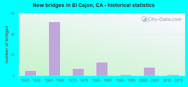
- New bridges - historical statistics
- 51950-1959
- 521960-1969
- 71970-1979
- 131980-1989
- 11990-1999
- 82000-2009
- 12010-2019

- Reconstructed bridges - Historical Statistics
- 91960-1969
- 31970-1979
- 21980-1989
- 01990-1999
- 22000-2009


- Bridge Condition - Deck
- 70.3%Good
- 29.7%Fair

- Bridge Condition - Superstructure
- 94.6%Good
- 2.7%Satisfactory
- 2.7%Fair

- Bridge Condition - Substructure
- 94.6%Good
- 5.4%Fair

- Bridge Condition - Channel
- 66.7%Excellent
- 9.5%Very good
- 4.8%Good
- 14.3%Satisfactory
- 4.8%Fair

- Bridge Condition - Culverts
- 87.5%Good
- 12.5%Satisfactory
Find on map >> Show street view
Structure Number: 57 0084, Location: 11-SD-067-R0.09-ECJ (Lat: 32.804381, Lng: -116.962175), Route carried "on" structure: State highway 67, Year Built: 1956, Year Reconstructed: 1966, Status: Open, Structure Length: 1.19m (3.90ft), Average Daily Traffic: 37,000 (year 2009), Truck Traffic: 8%, Average Future Daily Traffic: 62,000 (year 2035), Features Intersected: FORESTER CREEK
Minimum Vertical Clearance: 30+ m (98+ ft), Kilometerpoint: 0.090, Lanes on structure: 4, Base Highway Network: Yes (, Subroute: 1), Owner: State Highway Agency, Approaching Roadway Width: 37.8m (124.0ft), Skew: 20 degrees, Material/Design: Concrete continuous, Design/Construction: Culvert, Number Of Spans In Main Unit: 3, Length of Maximum Span: 3.7m (12.1ft), Curb-To-Curb Width: 36.6m (120.1ft), Out-to-Out Width: 37.8m (124.0ft)
Condition: Channel: Very good, Culverts: Good, Operating Rating: 54.1 metric tons, Method Used To Determine Operating Rating: Field evaluation and documented engineering judgment, Inventory Rating: 32.4 metric tons, Method Used To Determine Inventory Rating: Field evaluation and documented engineering judgment, Structural Evaluation: Better than present minimum criteria, Deck Geometry: Superior to present desirable criteria, Waterway Adequacy: Equal to present desirable criteria, Approach Roadway Alignment: Equal to present desirable criteria, Designated Inspection Frequency: Every 48 months, Inspection Date: August 2018
Find on map >> Show street view
Structure Number: 57 0084F, Location: 11-SD-067-R0.09-ECJ (Lat: 32.804419, Lng: -116.963044), Route carried "on" structure: Ramp State highway 67, Year Built: 1961, Status: Open, Structure Length: 1.77m (5.81ft), Average Daily Traffic: 10,000 (year 2010), Truck Traffic: 6%, Average Future Daily Traffic: 15,405 (year 2035), Features Intersected: FORESTER CREEK
Minimum Vertical Clearance: 30+ m (98+ ft), Kilometerpoint: 0.090, Lanes on structure: 3, Owner: State Highway Agency, Approaching Roadway Width: 12.0m (39.4ft), Skew: 4 degrees, Material/Design: Concrete, Design/Construction: Culvert, Number Of Spans In Main Unit: 3, Length of Maximum Span: 5.8m (19.0ft)
Condition: Channel: Very good, Culverts: Satisfactory, Operating Rating: 54.1 metric tons, Method Used To Determine Operating Rating: Field evaluation and documented engineering judgment, Inventory Rating: 32.4 metric tons, Method Used To Determine Inventory Rating: Field evaluation and documented engineering judgment, Structural Evaluation: Equal to present minimum criteria, Waterway Adequacy: Equal to present desirable criteria, Approach Roadway Alignment: Superior to present desirable criteria, Designated Inspection Frequency: Every 48 months, Inspection Date: August 2018
Find on map >> Show street view
Structure Number: 57 036, Location: 11-SD-094-2.46-SD (Lat: 32.713994, Lng: -117.129819), Route carried "on" structure: City street , Year Built: 1959, Status: Open, Structure Length: 8.53m (27.99ft), Average Daily Traffic: 6,020 (year 2016), Truck Traffic: 1%, Average Future Daily Traffic: 10,653 (year 2042), Design Load: HS 20, Features Intersected: STATE ROUTE 94, Facility Carried by Structure: 30TH STREET
Minimum Vertical Clearance: 30+ m (98+ ft), Kilometerpoint: 0.000, Lanes on structure: 2, Lanes under structure: 8, Owner: State Highway Agency, Approaching Roadway Width: 15.8m (51.8ft), Skew: 3 degrees, Material/Design: Concrete continuous, Design/Construction: Box Beam or Girders - Multiple, Number Of Spans In Main Unit: 4, Length of Maximum Span: 29.3m (96.1ft), Curb or Sidewalk Widths: Left: 1.5m (4.9ft), Right: 1.5m (4.9ft), Curb-To-Curb Width: 15.8m (51.8ft), Out-to-Out Width: 19.4m (63.6ft)
Condition: Deck: Fair, Superstructure: Good, Substructure: Good, Operating Rating: 56.4 metric tons, Method Used To Determine Operating Rating: Load and Resistance Factor Rating (LRFR) rating reported by rating factor(RF) method using HL-93 loadings, Inventory Rating: 40.5 metric tons, Method Used To Determine Inventory Rating: Load and Resistance Factor Rating (LRFR) rating reported by rating factor(RF) method using HL-93 loadings, Structural Evaluation: Better than present minimum criteria, Deck Geometry: Superior to present desirable criteria, Underclear: Meets minimum limits, Approach Roadway Alignment: Equal to present desirable criteria, Designated Inspection Frequency: Every 24 months, Inspection Date: December 2020, Deck Structure Type: Concrete Cast-file-Place, Wearing Surface/Protective System: Wearing Surface: Monolithic Concrete
Find on map >> Show street view
Structure Number: 57 0362, Location: 11-SD-008-13.66-ECJ (Lat: 32.782517, Lng: -116.981275), Route carried "on" structure: Interstate 8, Year Built: 1961, Year Reconstructed: 1968, Status: Open, Structure Length: 9.94m (32.61ft), Average Daily Traffic: 192,000 (year 2010), Truck Traffic: 5%, Average Future Daily Traffic: 238,000 (year 2037), Design Load: HS 20, Features Intersected: MTDB LRT & SDIV RR
Minimum Vertical Clearance: 30+ m (98+ ft), Kilometerpoint: 13.660, Lanes on structure: 8, Lanes under structure: 4, Base Highway Network: Yes (, Subroute: 1), Owner: State Highway Agency, Approaching Roadway Width: 41.5m (136.2ft), Skew: 35 degrees, Material/Design: Concrete continuous, Design/Construction: Box Beam or Girders - Multiple, Number Of Spans In Main Unit: 4, Length of Maximum Span: 27.7m (90.9ft), Curb-To-Curb Width: 41.4m (135.8ft), Out-to-Out Width: 42.9m (140.7ft)
Condition: Deck: Fair, Superstructure: Good, Substructure: Good, Operating Rating: 41.5 metric tons, Method Used To Determine Operating Rating: Load and Resistance Factor Rating (LRFR) rating reported by rating factor(RF) method using HL-93 loadings, Inventory Rating: 27.9 metric tons, Method Used To Determine Inventory Rating: Load and Resistance Factor Rating (LRFR) rating reported by rating factor(RF) method using HL-93 loadings, Structural Evaluation: Better than present minimum criteria, Deck Geometry: Superior to present desirable criteria, Underclear: Meets minimum limits, Approach Roadway Alignment: Equal to present desirable criteria, Designated Inspection Frequency: Every 24 months, Inspection Date: May 2020, Deck Structure Type: Concrete Cast-file-Place, Wearing Surface/Protective System: Wearing Surface: Other
Find on map >> Show street view
Structure Number: 57 0363, Location: 11-SD-008-14.59-ECJ (Lat: 32.794867, Lng: -116.977028), Route carried "on" structure: Interstate 8, Year Built: 1961, Year Reconstructed: 1968, Status: Open, Structure Length: 2.41m (7.91ft), Average Daily Traffic: 192,000 (year 2010), Truck Traffic: 5%, Average Future Daily Traffic: 238,000 (year 2037), Design Load: HS 20, Features Intersected: MAIN STREET
Minimum Vertical Clearance: 30+ m (98+ ft), Kilometerpoint: 14.590, Lanes on structure: 8, Lanes under structure: 6, Base Highway Network: Yes (, Subroute: 1), Owner: State Highway Agency, Approaching Roadway Width: 42.0m (137.8ft), Skew: 30 degrees, Material/Design: Concrete, Design/Construction: Box Beam or Girders - Multiple, Number Of Spans In Main Unit: 1, Length of Maximum Span: 24.1m (79.1ft), Curb-To-Curb Width: 41.5m (136.2ft), Out-to-Out Width: 43.2m (141.7ft)
Condition: Deck: Good, Superstructure: Good, Substructure: Good, Operating Rating: 99.8 metric tons, Method Used To Determine Operating Rating: Load Factor (LF), Inventory Rating: 32.4 metric tons, Method Used To Determine Inventory Rating: Load Factor (LF), Structural Evaluation: Better than present minimum criteria, Deck Geometry: Superior to present desirable criteria, Underclear: Meets minimum limits, Approach Roadway Alignment: Equal to present desirable criteria, Designated Inspection Frequency: Every 24 months, Inspection Date: May 2020, Deck Structure Type: Concrete Cast-file-Place
Find on map >> Show street view
Structure Number: 57 0364, Location: 11-SD-008-15.30-ECJ (Lat: 32.802614, Lng: -116.971172), Route carried "on" structure: Interstate 8, Year Built: 1961, Year Reconstructed: 1983, Status: Open, Structure Length: 1.92m (6.30ft), Average Daily Traffic: 188,000 (year 2010), Truck Traffic: 5%, Average Future Daily Traffic: 238,000 (year 2037), Design Load: HS 20, Features Intersected: JOHNSON AVE
Minimum Vertical Clearance: 30+ m (98+ ft), Kilometerpoint: 15.300, Lanes on structure: 9, Lanes under structure: 4, Base Highway Network: Yes (, Subroute: 1), Owner: State Highway Agency, Approaching Roadway Width: 44.8m (147.0ft), Skew: 31 degrees, Material/Design: Concrete, Design/Construction: Box Beam or Girders - Multiple, Number Of Spans In Main Unit: 1, Length of Maximum Span: 18.9m (62.0ft), Curb-To-Curb Width: 44.8m (147.0ft), Out-to-Out Width: 46.4m (152.2ft)
Condition: Deck: Good, Superstructure: Good, Substructure: Good, Operating Rating: 54.1 metric tons, Method Used To Determine Operating Rating: Assigned rating based on Load Factor Design (LFD) reported in metric tons, Inventory Rating: 32.4 metric tons, Method Used To Determine Inventory Rating: Assigned rating based on Load Factor Design (LFD) reported in metric tons, Structural Evaluation: Better than present minimum criteria, Deck Geometry: Superior to present desirable criteria, Underclear: Meets minimum limits, Approach Roadway Alignment: Equal to present desirable criteria, Length Of Structure Improvement: 1.92m (6.30ft), Designated Inspection Frequency: Every 24 months, Inspection Date: May 2020, Deck Structure Type: Concrete Cast-file-Place
Find on map >> Show street view
Structure Number: 57 0365, Location: 11-SD-008-15.80-ECJ (Lat: 32.802889, Lng: -116.962603), Route carried "on" structure: Interstate 8, Year Built: 1961, Year Reconstructed: 1968, Status: Open, Structure Length: 3.66m (12.01ft), Average Daily Traffic: 151,000 (year 2012), Truck Traffic: 5%, Average Future Daily Traffic: 238,000 (year 2037), Design Load: HS 20, Features Intersected: STATE ROUTE 67
Minimum Vertical Clearance: 30+ m (98+ ft), Kilometerpoint: 15.800, Lanes on structure: 6, Lanes under structure: 6, Base Highway Network: Yes (, Subroute: 1), Owner: State Highway Agency, Approaching Roadway Width: 42.1m (138.1ft), Skew: 30 degrees, Material/Design: Concrete continuous, Design/Construction: Box Beam or Girders - Multiple, Number Of Spans In Main Unit: 2, Length of Maximum Span: 18.3m (60.0ft), Curb-To-Curb Width: 41.3m (135.5ft), Out-to-Out Width: 42.9m (140.7ft)
Condition: Deck: Fair, Superstructure: Good, Substructure: Good, Operating Rating: 61.2 metric tons, Method Used To Determine Operating Rating: Load Factor (LF), Inventory Rating: 36.6 metric tons, Method Used To Determine Inventory Rating: Load Factor (LF), Structural Evaluation: Better than present minimum criteria, Deck Geometry: Superior to present desirable criteria, Underclear: Meets minimum limits, Approach Roadway Alignment: Equal to present desirable criteria, Designated Inspection Frequency: Every 24 months, Inspection Date: May 2020, Deck Structure Type: Concrete Cast-file-Place
Find on map >> Show street view
Structure Number: 57 0365F, Location: 11-SD-008-15.80-ECJ (Lat: 32.803292, Lng: -116.962594), Route carried "on" structure: Ramp Interstate 8, Year Built: 1961, Status: Open, Structure Length: 3.66m (12.01ft), Average Daily Traffic: 23,200 (year 2010), Truck Traffic: 2%, Average Future Daily Traffic: 25,000 (year 2037), Design Load: HS 20, Features Intersected: ST RTE 67 & CONNECTORS
Minimum Vertical Clearance: 30+ m (98+ ft), Kilometerpoint: 15.800, Lanes on structure: 2, Lanes under structure: 6, Base Highway Network: Yes (, Subroute: 1), Owner: State Highway Agency, Approaching Roadway Width: 8.5m (27.9ft), Material/Design: Concrete continuous, Design/Construction: Box Beam or Girders - Multiple, Number Of Spans In Main Unit: 2, Length of Maximum Span: 18.3m (60.0ft), Curb or Sidewalk Widths: Left: 0.6m (2.0ft), Right: 0.6m (2.0ft), Curb-To-Curb Width: 8.5m (27.9ft), Out-to-Out Width: 10.4m (34.1ft)
Condition: Deck: Good, Superstructure: Good, Substructure: Good, Operating Rating: 43.4 metric tons, Method Used To Determine Operating Rating: Load and Resistance Factor Rating (LRFR) rating reported by rating factor(RF) method using HL-93 loadings, Inventory Rating: 33.7 metric tons, Method Used To Determine Inventory Rating: Load and Resistance Factor Rating (LRFR) rating reported by rating factor(RF) method using HL-93 loadings, Structural Evaluation: Better than present minimum criteria, Deck Geometry: High priority of corrective action, Underclear: Meets minimum limits, Approach Roadway Alignment: Equal to present desirable criteria, Designated Inspection Frequency: Every 48 months, Inspection Date: May 2020, Deck Structure Type: Concrete Cast-file-Place
Find on map >> Show street view
Structure Number: 57 0365G, Location: 11-SD-008-15.80-ECJ (Lat: 32.802772, Lng: -116.962592), Route carried "on" structure: Ramp Interstate 8, Year Built: 1961, Status: Open, Structure Length: 3.66m (12.01ft), Average Daily Traffic: 13,250 (year 2010), Truck Traffic: 2%, Average Future Daily Traffic: 30,809 (year 2037), Design Load: HS 20, Features Intersected: ST RTE 67 & CONNECTORS
Minimum Vertical Clearance: 30+ m (98+ ft), Kilometerpoint: 15.800, Lanes on structure: 2, Lanes under structure: 6, Base Highway Network: Yes (, Subroute: 1), Owner: State Highway Agency, Approaching Roadway Width: 8.5m (27.9ft), Material/Design: Concrete continuous, Design/Construction: Box Beam or Girders - Multiple, Number Of Spans In Main Unit: 2, Length of Maximum Span: 18.3m (60.0ft), Curb or Sidewalk Widths: Left: 0.6m (2.0ft), Right: 0.6m (2.0ft), Curb-To-Curb Width: 8.5m (27.9ft), Out-to-Out Width: 10.4m (34.1ft)
Condition: Deck: Good, Superstructure: Good, Substructure: Good, Operating Rating: 43.4 metric tons, Method Used To Determine Operating Rating: Load and Resistance Factor Rating (LRFR) rating reported by rating factor(RF) method using HL-93 loadings, Inventory Rating: 33.7 metric tons, Method Used To Determine Inventory Rating: Load and Resistance Factor Rating (LRFR) rating reported by rating factor(RF) method using HL-93 loadings, Structural Evaluation: Better than present minimum criteria, Deck Geometry: High priority of corrective action, Underclear: Meets minimum limits, Approach Roadway Alignment: Equal to present desirable criteria, Designated Inspection Frequency: Every 48 months, Inspection Date: May 2020, Deck Structure Type: Concrete Cast-file-Place
Find on map >> Show street view
Structure Number: 57 0366, Location: 11-SD-008-16.05-ECJ (Lat: 32.802881, Lng: -116.958236), Route carried "on" structure: Interstate 8, Year Built: 1961, Year Reconstructed: 1968, Status: Open, Structure Length: 1.83m (6.00ft), Average Daily Traffic: 134,000 (year 2010), Truck Traffic: 5%, Average Future Daily Traffic: 238,000 (year 2037), Design Load: HS 20, Features Intersected: BALLANTYNE LANE
Minimum Vertical Clearance: 30+ m (98+ ft), Kilometerpoint: 16.050, Lanes on structure: 7, Lanes under structure: 4, Base Highway Network: Yes (, Subroute: 1), Owner: State Highway Agency, Approaching Roadway Width: 40.0m (131.2ft), Skew: 30 degrees, Material/Design: Concrete, Design/Construction: Box Beam or Girders - Multiple, Number Of Spans In Main Unit: 1, Length of Maximum Span: 18.3m (60.0ft), Curb-To-Curb Width: 42.7m (140.1ft), Out-to-Out Width: 44.0m (144.4ft)
Condition: Deck: Good, Superstructure: Good, Substructure: Good, Operating Rating: 84.9 metric tons, Method Used To Determine Operating Rating: Load Factor (LF), Inventory Rating: 32.4 metric tons, Method Used To Determine Inventory Rating: Load Factor (LF), Structural Evaluation: Better than present minimum criteria, Deck Geometry: Superior to present desirable criteria, Underclear: Meets minimum limits, Approach Roadway Alignment: Equal to present desirable criteria, Length Of Structure Improvement: 1.83m (6.00ft), Designated Inspection Frequency: Every 48 months, Inspection Date: May 2020, Deck Structure Type: Concrete Cast-file-Place
Find on map >> Show street view
Structure Number: 57 0366F, Location: 11-SD-008-16.05-ECJ (Lat: 32.803297, Lng: -116.958236), Route carried "on" structure: Ramp Interstate 8, Year Built: 1961, Status: Open, Structure Length: 1.83m (6.00ft), Average Daily Traffic: 11,000 (year 2009), Truck Traffic: 2%, Average Future Daily Traffic: 25,335 (year 2036), Design Load: HS 20, Features Intersected: BALLANTYNE LANE
Minimum Vertical Clearance: 30+ m (98+ ft), Kilometerpoint: 16.050, Lanes on structure: 1, Lanes under structure: 4, Base Highway Network: Yes (, Subroute: 1), Owner: State Highway Agency, Approaching Roadway Width: 7.0m (23.0ft), Material/Design: Concrete, Design/Construction: Box Beam or Girders - Multiple, Number Of Spans In Main Unit: 1, Length of Maximum Span: 18.3m (60.0ft), Curb or Sidewalk Widths: Left: 0.0m, Right: 0.6m (2.0ft), Curb-To-Curb Width: 6.7m (22.0ft), Out-to-Out Width: 8.0m (26.2ft)
Condition: Deck: Good, Superstructure: Good, Substructure: Good, Operating Rating: 49.2 metric tons, Method Used To Determine Operating Rating: Load and Resistance Factor Rating (LRFR) rating reported by rating factor(RF) method using HL-93 loadings, Inventory Rating: 38.2 metric tons, Method Used To Determine Inventory Rating: Load and Resistance Factor Rating (LRFR) rating reported by rating factor(RF) method using HL-93 loadings, Structural Evaluation: Better than present minimum criteria, Deck Geometry: Equal to present minimum criteria, Underclear: Meets minimum limits, Approach Roadway Alignment: Equal to present desirable criteria, Designated Inspection Frequency: Every 48 months, Inspection Date: May 2018, Deck Structure Type: Concrete Cast-file-Place
Find on map >> Show street view
Structure Number: 57 0369, Location: 11-SD-008-14.95-ECJ (Lat: 32.799347, Lng: -116.975861), Route carried "on" structure: Interstate 8, Year Built: 1961, Year Reconstructed: 1985, Status: Open, Structure Length: 8.75m (28.71ft), Average Daily Traffic: 189,000 (year 2010), Truck Traffic: 5%, Average Future Daily Traffic: 241,189 (year 2037), Design Load: HS 20, Features Intersected: MTDB LRT,SDIV & MARSHALL
Minimum Vertical Clearance: 30+ m (98+ ft), Kilometerpoint: 14.950, Lanes on structure: 10, Lanes under structure: 4, Base Highway Network: Yes (, Subroute: 1), Owner: State Highway Agency, Approaching Roadway Width: 48.2m (158.1ft), Skew: 39 degrees, Material/Design: Concrete continuous, Design/Construction: Box Beam or Girders - Multiple, Number Of Spans In Main Unit: 4, Length of Maximum Span: 22.9m (75.1ft), Curb-To-Curb Width: 48.2m (158.1ft), Out-to-Out Width: 50.0m (164.0ft)
Condition: Deck: Fair, Superstructure: Good, Substructure: Good, Operating Rating: 67.7 metric tons, Method Used To Determine Operating Rating: Load Factor (LF), Inventory Rating: 32.4 metric tons, Method Used To Determine Inventory Rating: Load Factor (LF), Structural Evaluation: Better than present minimum criteria, Deck Geometry: Superior to present desirable criteria, Underclear: Meets minimum limits, Approach Roadway Alignment: Equal to present desirable criteria, Designated Inspection Frequency: Every 24 months, Inspection Date: May 2020, Deck Structure Type: Concrete Cast-file-Place, Wearing Surface/Protective System: Wearing Surface: Monolithic Concrete
Find on map >> Show street view
Structure Number: 57 0371R, Location: 11-SD-008-7.06-SD (Lat: 32.780464, Lng: -117.088228), Route carried "on" structure: Interstate 8, Year Built: 1960, Year Reconstructed: 1979, Status: Open, Structure Length: 4.27m (14.01ft), Average Daily Traffic: 108,500 (year 2010), Truck Traffic: 4%, Average Future Daily Traffic: 141,293 (year 2040), Design Load: HS 20, Features Intersected: WARING ROAD
Minimum Vertical Clearance: 30+ m (98+ ft), Kilometerpoint: 7.060, Lanes on structure: 5, Lanes under structure: 3, Base Highway Network: Yes (, Subroute: 1), Owner: State Highway Agency, Approaching Roadway Width: 27.4m (89.9ft), Skew: 2 degrees, Material/Design: Concrete continuous, Design/Construction: Tee Beam, Number Of Spans In Main Unit: 3, Length of Maximum Span: 18.3m (60.0ft), Curb-To-Curb Width: 27.4m (89.9ft), Out-to-Out Width: 28.6m (93.8ft)
Condition: Deck: Good, Superstructure: Good, Substructure: Good, Operating Rating: 28.5 metric tons, Method Used To Determine Operating Rating: Load and Resistance Factor Rating (LRFR) rating reported by rating factor(RF) method using HL-93 loadings, Inventory Rating: 22.0 metric tons, Method Used To Determine Inventory Rating: Load and Resistance Factor Rating (LRFR) rating reported by rating factor(RF) method using HL-93 loadings, Structural Evaluation: Somewhat better than minimum adequacy, Deck Geometry: Superior to present desirable criteria, Underclear: High priority of corrective action, Approach Roadway Alignment: Equal to present desirable criteria, Designated Inspection Frequency: Every 24 months, Inspection Date: March 2020, Deck Structure Type: Concrete Cast-file-Place
Find on map >> Show street view
Structure Number: 57 0377, Location: 11-SD-008-16.47-ECJ (Lat: 32.802897, Lng: -116.951131), Route carried "on" structure: Interstate 8, Year Built: 1961, Year Reconstructed: 1968, Status: Open, Structure Length: 2.38m (7.81ft), Average Daily Traffic: 117,000 (year 2010), Truck Traffic: 3%, Average Future Daily Traffic: 179,000 (year 2037), Design Load: HS 20, Features Intersected: MOLLISON AVE
Minimum Vertical Clearance: 30+ m (98+ ft), Kilometerpoint: 16.470, Lanes on structure: 6, Lanes under structure: 5, Base Highway Network: Yes (, Subroute: 1), Owner: State Highway Agency, Approaching Roadway Width: 31.7m (104.0ft), Material/Design: Concrete, Design/Construction: Box Beam or Girders - Multiple, Number Of Spans In Main Unit: 1, Length of Maximum Span: 23.5m (77.1ft), Curb-To-Curb Width: 42.7m (140.1ft), Out-to-Out Width: 43.5m (142.7ft)
Condition: Deck: Good, Superstructure: Good, Substructure: Fair, Operating Rating: 74.8 metric tons, Method Used To Determine Operating Rating: Load Factor (LF), Inventory Rating: 32.4 metric tons, Method Used To Determine Inventory Rating: Load Factor (LF), Structural Evaluation: Somewhat better than minimum adequacy, Deck Geometry: Superior to present desirable criteria, Underclear: Meets minimum limits, Approach Roadway Alignment: Equal to present desirable criteria, Designated Inspection Frequency: Every 24 months, Inspection Date: June 2020, Deck Structure Type: Concrete Cast-file-Place
Find on map >> Show street view
Structure Number: 57 0378, Location: 11-SD-008-16.84-ECJ (Lat: 32.802894, Lng: -116.944700), Route carried "on" structure: Interstate 8, Year Built: 1961, Year Reconstructed: 1968, Status: Open, Structure Length: 1.83m (6.00ft), Average Daily Traffic: 117,000 (year 2010), Truck Traffic: 3%, Average Future Daily Traffic: 179,000 (year 2037), Design Load: HS 20, Features Intersected: FIRST STREET
Minimum Vertical Clearance: 30+ m (98+ ft), Kilometerpoint: 16.840, Lanes on structure: 6, Lanes under structure: 2, Base Highway Network: Yes (, Subroute: 1), Owner: State Highway Agency, Approaching Roadway Width: 31.7m (104.0ft), Material/Design: Concrete, Design/Construction: Box Beam or Girders - Multiple, Number Of Spans In Main Unit: 1, Length of Maximum Span: 17.7m (58.1ft), Curb-To-Curb Width: 36.0m (118.1ft), Out-to-Out Width: 43.5m (142.7ft)
Condition: Deck: Good, Superstructure: Good, Substructure: Good, Operating Rating: 70.3 metric tons, Method Used To Determine Operating Rating: Load Factor (LF), Inventory Rating: 32.4 metric tons, Method Used To Determine Inventory Rating: Load Factor (LF), Structural Evaluation: Better than present minimum criteria, Deck Geometry: Superior to present desirable criteria, Underclear: Somewhat better than minimum adequacy, Approach Roadway Alignment: Equal to present desirable criteria, Designated Inspection Frequency: Every 48 months, Inspection Date: May 2020, Deck Structure Type: Concrete Cast-file-Place
Find on map >> Show street view
Structure Number: 57 0379L, Location: 11-SD-008-17.35-ECJ (Lat: 32.803178, Lng: -116.935939), Route carried "on" structure: Interstate 8, Year Built: 1961, Status: Open, Structure Length: 3.29m (10.79ft), Average Daily Traffic: 53,000 (year 2012), Truck Traffic: 3%, Average Future Daily Traffic: 89,500 (year 2037), Design Load: HS 20+Mod, Features Intersected: 2ND STREET
Minimum Vertical Clearance: 30+ m (98+ ft), Kilometerpoint: 17.350, Lanes on structure: 2, Lanes under structure: 6, Base Highway Network: Yes (, Subroute: 1), Owner: State Highway Agency, Approaching Roadway Width: 11.9m (39.0ft), Material/Design: Concrete, Design/Construction: Box Beam or Girders - Multiple, Number Of Spans In Main Unit: 1, Length of Maximum Span: 32.9m (107.9ft), Curb-To-Curb Width: 11.9m (39.0ft), Out-to-Out Width: 12.7m (41.7ft)
Condition: Deck: Good, Superstructure: Good, Substructure: Good, Operating Rating: 51.5 metric tons, Method Used To Determine Operating Rating: Load and Resistance Factor Rating (LRFR) rating reported by rating factor(RF) method using HL-93 loadings, Inventory Rating: 37.3 metric tons, Method Used To Determine Inventory Rating: Load and Resistance Factor Rating (LRFR) rating reported by rating factor(RF) method using HL-93 loadings, Structural Evaluation: Better than present minimum criteria, Deck Geometry: Equal to present minimum criteria, Underclear: Equal to present minimum criteria, Approach Roadway Alignment: Equal to present desirable criteria, Designated Inspection Frequency: Every 24 months, Inspection Date: May 2020, Deck Structure Type: Concrete Cast-file-Place
Find on map >> Show street view
Structure Number: 57 0379R, Location: 11-SD-008-17.35-ECJ (Lat: 32.802900, Lng: -116.935939), Route carried "on" structure: Interstate 8, Year Built: 1961, Year Reconstructed: 1968, Status: Open, Structure Length: 3.29m (10.79ft), Average Daily Traffic: 53,000 (year 2012), Truck Traffic: 3%, Average Future Daily Traffic: 89,500 (year 2037), Design Load: HS 20+Mod, Features Intersected: 2ND STREET
Minimum Vertical Clearance: 30+ m (98+ ft), Kilometerpoint: 17.350, Lanes on structure: 3, Lanes under structure: 6, Base Highway Network: Yes (, Subroute: 1), Owner: State Highway Agency, Approaching Roadway Width: 15.6m (51.2ft), Material/Design: Concrete, Design/Construction: Box Beam or Girders - Multiple, Number Of Spans In Main Unit: 1, Length of Maximum Span: 32.9m (107.9ft), Curb-To-Curb Width: 15.6m (51.2ft), Out-to-Out Width: 16.2m (53.1ft)
Condition: Deck: Good, Superstructure: Good, Substructure: Good, Operating Rating: 51.5 metric tons, Method Used To Determine Operating Rating: Load and Resistance Factor Rating (LRFR) rating reported by rating factor(RF) method using HL-93 loadings, Inventory Rating: 37.3 metric tons, Method Used To Determine Inventory Rating: Load and Resistance Factor Rating (LRFR) rating reported by rating factor(RF) method using HL-93 loadings, Structural Evaluation: Better than present minimum criteria, Deck Geometry: Somewhat better than minimum adequacy, Underclear: Somewhat better than minimum adequacy, Approach Roadway Alignment: Equal to present desirable criteria, Designated Inspection Frequency: Every 24 months, Inspection Date: May 2020, Deck Structure Type: Concrete Cast-file-Place
Find on map >> Show street view
Structure Number: 57 0381R, Location: 11-SD-008-17.83-ECJ (Lat: 32.802906, Lng: -116.927933), Route carried "on" structure: Interstate 8, Year Built: 1961, Year Reconstructed: 2011, Status: Open, Structure Length: 4.54m (14.90ft), Average Daily Traffic: 44,500 (year 2010), Truck Traffic: 7%, Average Future Daily Traffic: 69,000 (year 2037), Design Load: HS 20, Features Intersected: EAST MAIN STREET
Minimum Vertical Clearance: 30+ m (98+ ft), Kilometerpoint: 17.830, Lanes on structure: 3, Lanes under structure: 5, Base Highway Network: Yes (, Subroute: 1), Owner: State Highway Agency, Approaching Roadway Width: 17.0m (55.8ft), Skew: 4 degrees, Material/Design: Concrete continuous, Design/Construction: Box Beam or Girders - Multiple, Number Of Spans In Main Unit: 2, Length of Maximum Span: 23.5m (77.1ft), Curb-To-Curb Width: 17.0m (55.8ft), Out-to-Out Width: 18.0m (59.1ft)
Condition: Deck: Good, Superstructure: Good, Substructure: Good, Operating Rating: 59.0 metric tons, Method Used To Determine Operating Rating: Load and Resistance Factor Rating (LRFR) rating reported by rating factor(RF) method using HL-93 loadings, Inventory Rating: 42.8 metric tons, Method Used To Determine Inventory Rating: Load and Resistance Factor Rating (LRFR) rating reported by rating factor(RF) method using HL-93 loadings, Structural Evaluation: Better than present minimum criteria, Deck Geometry: Equal to present minimum criteria, Underclear: Meets minimum limits, Approach Roadway Alignment: Equal to present desirable criteria, Designated Inspection Frequency: Every 48 months, Inspection Date: May 2020, Deck Structure Type: Concrete Cast-file-Place, Wearing Surface/Protective System: Wearing Surface: Monolithic Concrete
Find on map >> Show street view
Structure Number: 57 0465, Location: 11-SD-008-15.63-ECJ (Lat: 32.802897, Lng: -116.965544), Route carried "on" structure: Interstate 8, Year Built: 1961, Year Reconstructed: 1968, Status: Open, Structure Length: 0.98m (3.22ft), Average Daily Traffic: 189,000 (year 2009), Truck Traffic: 5%, Average Future Daily Traffic: 241,189 (year 2036), Features Intersected: EL CAJON CREEK
Minimum Vertical Clearance: 30+ m (98+ ft), Kilometerpoint: 15.630, Lanes on structure: 12, Base Highway Network: Yes (, Subroute: 1), Owner: State Highway Agency, Approaching Roadway Width: 67.4m (221.1ft), Skew: 20 degrees, Material/Design: Concrete, Design/Construction: Culvert, Number Of Spans In Main Unit: 3, Length of Maximum Span: 3.0m (9.8ft), Curb-To-Curb Width: 67.4m (221.1ft), Out-to-Out Width: 78.8m (258.5ft)
Condition: Channel: Excellent, Culverts: Good, Operating Rating: 54.1 metric tons, Method Used To Determine Operating Rating: Field evaluation and documented engineering judgment, Inventory Rating: 32.4 metric tons, Method Used To Determine Inventory Rating: Field evaluation and documented engineering judgment, Structural Evaluation: Better than present minimum criteria, Deck Geometry: Superior to present desirable criteria, Waterway Adequacy: Equal to present desirable criteria, Approach Roadway Alignment: Equal to present desirable criteria, Designated Inspection Frequency: Every 48 months, Inspection Date: May 2018
Find on map >> Show street view
Structure Number: 57 0475L, Location: 11-SD-008-R18.41-ECJ (Lat: 32.807544, Lng: -116.919931), Route carried "on" structure: Interstate 8, Year Built: 1965, Status: Open, Structure Length: 4.54m (14.90ft), Average Daily Traffic: 48,000 (year 2012), Truck Traffic: 7%, Average Future Daily Traffic: 69,000 (year 2037), Design Load: HS 20, Features Intersected: BROADWAY
Minimum Vertical Clearance: 30+ m (98+ ft), Kilometerpoint: 18.410, Lanes on structure: 2, Lanes under structure: 2, Base Highway Network: Yes (, Subroute: 1), Owner: State Highway Agency, Approaching Roadway Width: 11.9m (39.0ft), Skew: 2 degrees, Material/Design: Concrete continuous, Design/Construction: Tee Beam, Number Of Spans In Main Unit: 3, Length of Maximum Span: 18.9m (62.0ft), Curb-To-Curb Width: 12.1m (39.7ft), Out-to-Out Width: 12.7m (41.7ft)
Condition: Deck: Good, Superstructure: Good, Substructure: Good, Operating Rating: 37.6 metric tons, Method Used To Determine Operating Rating: Load and Resistance Factor Rating (LRFR) rating reported by rating factor(RF) method using HL-93 loadings, Inventory Rating: 28.8 metric tons, Method Used To Determine Inventory Rating: Load and Resistance Factor Rating (LRFR) rating reported by rating factor(RF) method using HL-93 loadings, Structural Evaluation: Better than present minimum criteria, Deck Geometry: Equal to present minimum criteria, Underclear: Meets minimum limits, Approach Roadway Alignment: Equal to present desirable criteria, Designated Inspection Frequency: Every 24 months, Inspection Date: May 2020, Deck Structure Type: Concrete Cast-file-Place
Find on map >> Show street view
Structure Number: 57 0475R, Location: 11-SD-008-R18.41-ECJ (Lat: 32.807542, Lng: -116.919567), Route carried "on" structure: Interstate 8, Year Built: 1965, Status: Open, Structure Length: 4.54m (14.90ft), Average Daily Traffic: 44,500 (year 2010), Truck Traffic: 7%, Average Future Daily Traffic: 69,000 (year 2037), Design Load: HS 20, Features Intersected: BROADWAY
Minimum Vertical Clearance: 30+ m (98+ ft), Kilometerpoint: 18.410, Lanes on structure: 3, Lanes under structure: 2, Base Highway Network: Yes (, Subroute: 1), Owner: State Highway Agency, Approaching Roadway Width: 17.0m (55.8ft), Skew: 2 degrees, Material/Design: Concrete continuous, Design/Construction: Tee Beam, Number Of Spans In Main Unit: 3, Length of Maximum Span: 18.9m (62.0ft), Curb-To-Curb Width: 17.0m (55.8ft), Out-to-Out Width: 18.0m (59.1ft)
Condition: Deck: Good, Superstructure: Good, Substructure: Good, Operating Rating: 37.6 metric tons, Method Used To Determine Operating Rating: Load and Resistance Factor Rating (LRFR) rating reported by rating factor(RF) method using HL-93 loadings, Inventory Rating: 28.8 metric tons, Method Used To Determine Inventory Rating: Load and Resistance Factor Rating (LRFR) rating reported by rating factor(RF) method using HL-93 loadings, Structural Evaluation: Better than present minimum criteria, Deck Geometry: Equal to present minimum criteria, Underclear: Meets minimum limits, Approach Roadway Alignment: Equal to present desirable criteria, Designated Inspection Frequency: Every 24 months, Inspection Date: May 2020, Deck Structure Type: Concrete Cast-file-Place
Find on map >> Show street view
Structure Number: 57 0476L, Location: 11-SD-008-R18.73-ECJ (Lat: 32.811661, Lng: -116.917403), Route carried "on" structure: Interstate 8, Year Built: 1965, Status: Open, Structure Length: 4.21m (13.81ft), Average Daily Traffic: 39,500 (year 2010), Truck Traffic: 7%, Average Future Daily Traffic: 69,000 (year 2037), Design Load: HS 20, Features Intersected: GREENFIELD DR
Minimum Vertical Clearance: 30+ m (98+ ft), Kilometerpoint: 18.730, Lanes on structure: 2, Lanes under structure: 5, Base Highway Network: Yes (, Subroute: 1), Owner: State Highway Agency, Approaching Roadway Width: 11.9m (39.0ft), Material/Design: Concrete continuous, Design/Construction: Tee Beam, Number Of Spans In Main Unit: 3, Length of Maximum Span: 20.4m (66.9ft), Curb-To-Curb Width: 12.1m (39.7ft), Out-to-Out Width: 12.7m (41.7ft)
Condition: Deck: Good, Superstructure: Good, Substructure: Good, Operating Rating: 35.3 metric tons, Method Used To Determine Operating Rating: Load and Resistance Factor Rating (LRFR) rating reported by rating factor(RF) method using HL-93 loadings, Inventory Rating: 27.2 metric tons, Method Used To Determine Inventory Rating: Load and Resistance Factor Rating (LRFR) rating reported by rating factor(RF) method using HL-93 loadings, Structural Evaluation: Equal to present minimum criteria, Deck Geometry: Equal to present minimum criteria, Underclear: Equal to present minimum criteria, Approach Roadway Alignment: Equal to present desirable criteria, Designated Inspection Frequency: Every 24 months, Inspection Date: May 2020, Deck Structure Type: Concrete Cast-file-Place
Find on map >> Show street view
Structure Number: 57 0476R, Location: 11-SD-008-R18.73-ECJ (Lat: 32.811544, Lng: -116.917106), Route carried "on" structure: Interstate 8, Year Built: 1965, Status: Open, Structure Length: 4.21m (13.81ft), Average Daily Traffic: 39,500 (year 2010), Truck Traffic: 7%, Average Future Daily Traffic: 69,000 (year 2037), Design Load: HS 20, Features Intersected: GREENFIELD DR
Minimum Vertical Clearance: 30+ m (98+ ft), Kilometerpoint: 18.730, Lanes on structure: 2, Lanes under structure: 5, Base Highway Network: Yes (, Subroute: 1), Owner: State Highway Agency, Approaching Roadway Width: 11.9m (39.0ft), Material/Design: Concrete continuous, Design/Construction: Tee Beam, Number Of Spans In Main Unit: 3, Length of Maximum Span: 20.4m (66.9ft), Curb-To-Curb Width: 12.1m (39.7ft), Out-to-Out Width: 12.7m (41.7ft)
Condition: Deck: Good, Superstructure: Good, Substructure: Good, Operating Rating: 35.3 metric tons, Method Used To Determine Operating Rating: Load and Resistance Factor Rating (LRFR) rating reported by rating factor(RF) method using HL-93 loadings, Inventory Rating: 27.2 metric tons, Method Used To Determine Inventory Rating: Load and Resistance Factor Rating (LRFR) rating reported by rating factor(RF) method using HL-93 loadings, Structural Evaluation: Equal to present minimum criteria, Deck Geometry: Equal to present minimum criteria, Underclear: Meets minimum limits, Approach Roadway Alignment: Equal to present desirable criteria, Designated Inspection Frequency: Every 24 months, Inspection Date: May 2020, Deck Structure Type: Concrete Cast-file-Place
Find on map >> Show street view
Structure Number: 57 0550G, Location: 11-SD-005-R19.90-SD (Lat: 32.757436, Lng: -117.201892), Route carried "on" structure: Ramp Interstate 5, Year Built: 1969, Status: Open, Structure Length: 20.39m (66.90ft), Average Daily Traffic: 20,200 (year 2020), Truck Traffic: 2%, Average Future Daily Traffic: 29,779 (year 2040), Design Load: HS 20, Features Intersected: BNSF,AMTRAK,MTDB,PACIFIC
Minimum Vertical Clearance: 30+ m (98+ ft), Kilometerpoint: 19.900, Lanes on structure: 1, Lanes under structure: 2, Base Highway Network: Yes, Owner: State Highway Agency, Approaching Roadway Width: 7.3m (24.0ft), Skew: 9 degrees, Material/Design: Concrete continuous, Design/Construction: Box Beam or Girders - Multiple, Number Of Spans In Main Unit: 7, Length of Maximum Span: 36.6m (120.1ft), Curb-To-Curb Width: 7.3m (24.0ft), Out-to-Out Width: 7.9m (25.9ft)
Condition: Deck: Good, Superstructure: Good, Substructure: Good, Operating Rating: 71.9 metric tons, Method Used To Determine Operating Rating: Load Factor (LF), Inventory Rating: 43.1 metric tons, Method Used To Determine Inventory Rating: Load Factor (LF), Structural Evaluation: Better than present minimum criteria, Deck Geometry: Better than present minimum criteria, Underclear: Equal to present minimum criteria, Approach Roadway Alignment: Equal to present desirable criteria, Designated Inspection Frequency: Every 24 months, Inspection Date: September 2021, Deck Structure Type: Concrete Cast-file-Place
Find on map >> Show street view
Structure Number: 57 0557F, Location: 11-SD-067-R0.16-ECJ (Lat: 32.804861, Lng: -116.962653), Route carried "on" structure: Ramp State highway 67, Year Built: 1967, Status: Open, Structure Length: 9.85m (32.32ft), Average Daily Traffic: 25,000 (year 2018), Truck Traffic: 5%, Average Future Daily Traffic: 30,809 (year 2040), Design Load: HS 20, Features Intersected: STATE ROUTE 67 SB
Minimum Vertical Clearance: 30+ m (98+ ft), Kilometerpoint: 0.160, Lanes on structure: 2, Lanes under structure: 2, Base Highway Network: Yes (, Subroute: 1), Owner: State Highway Agency, Approaching Roadway Width: 11.3m (37.1ft), Skew: 9 degrees, Material/Design: Concrete continuous, Design/Construction: Box Beam or Girders - Multiple, Number Of Spans In Main Unit: 3, Length of Maximum Span: 43.0m (141.1ft), Curb-To-Curb Width: 11.3m (37.1ft), Out-to-Out Width: 11.9m (39.0ft)
Condition: Deck: Good, Superstructure: Good, Substructure: Good, Operating Rating: 56.7 metric tons, Method Used To Determine Operating Rating: Load and Resistance Factor Rating (LRFR) rating reported by rating factor(RF) method using HL-93 loadings, Inventory Rating: 43.7 metric tons, Method Used To Determine Inventory Rating: Load and Resistance Factor Rating (LRFR) rating reported by rating factor(RF) method using HL-93 loadings, Structural Evaluation: Better than present minimum criteria, Deck Geometry: Superior to present desirable criteria, Underclear: Meets minimum limits, Approach Roadway Alignment: Superior to present desirable criteria, Designated Inspection Frequency: Every 24 months, Inspection Date: August 2020, Deck Structure Type: Concrete Cast-file-Place
Find on map >> Show street view
Structure Number: 57 0558F, Location: 11-SD-067-R0.31-ECJ (Lat: 32.807464, Lng: -116.962142), Route carried "on" structure: Ramp State highway 67, Year Built: 1967, Year Reconstructed: 1985, Status: Open, Structure Length: 5.60m (18.37ft), Average Daily Traffic: 30,000 (year 2018), Truck Traffic: 7%, Average Future Daily Traffic: 40,809 (year 2040), Design Load: HS 20, Features Intersected: BROADWAY
Minimum Vertical Clearance: 30+ m (98+ ft), Kilometerpoint: 0.310, Lanes on structure: 3, Lanes under structure: 8, Base Highway Network: Yes (, Subroute: 1), Owner: State Highway Agency, Approaching Roadway Width: 15.5m (50.9ft), Material/Design: Concrete continuous, Design/Construction: Box Beam or Girders - Multiple, Number Of Spans In Main Unit: 2, Length of Maximum Span: 29.6m (97.1ft), Curb-To-Curb Width: 14.7m (48.2ft), Out-to-Out Width: 15.5m (50.9ft)
Condition: Deck: Good, Superstructure: Good, Substructure: Good, Operating Rating: 96.9 metric tons, Method Used To Determine Operating Rating: Load Factor (LF), Inventory Rating: 58.3 metric tons, Method Used To Determine Inventory Rating: Load Factor (LF), Structural Evaluation: Better than present minimum criteria, Deck Geometry: Better than present minimum criteria, Underclear: High priority of corrective action, Approach Roadway Alignment: Equal to present desirable criteria, Designated Inspection Frequency: Every 48 months, Inspection Date: August 2020, Deck Structure Type: Concrete Cast-file-Place
Find on map >> Show street view
Structure Number: 57 0558G, Location: 11-SD-008-15.81-ECJ (Lat: 32.807564, Lng: -116.961956), Route carried "on" structure: Ramp Interstate 8, Year Built: 1985, Status: Open, Structure Length: 5.26m (17.26ft), Average Daily Traffic: 20,600 (year 2012), Truck Traffic: 2%, Average Future Daily Traffic: 41,630 (year 2037), Design Load: HS 20+Mod, Features Intersected: BROADWAY
Minimum Vertical Clearance: 30+ m (98+ ft), Kilometerpoint: 15.810, Lanes on structure: 2, Lanes under structure: 7, Base Highway Network: Yes (, Subroute: 1), Owner: State Highway Agency, Approaching Roadway Width: 11.9m (39.0ft), Material/Design: Concrete continuous, Design/Construction: Box Beam or Girders - Multiple, Number Of Spans In Main Unit: 2, Length of Maximum Span: 26.5m (86.9ft), Curb-To-Curb Width: 11.7m (38.4ft), Out-to-Out Width: 12.8m (42.0ft)
Condition: Deck: Fair, Superstructure: Good, Substructure: Good, Operating Rating: 54.1 metric tons, Method Used To Determine Operating Rating: Assigned rating based on Load Factor Design (LFD) reported in metric tons, Inventory Rating: 32.4 metric tons, Method Used To Determine Inventory Rating: Assigned rating based on Load Factor Design (LFD) reported in metric tons, Structural Evaluation: Better than present minimum criteria, Deck Geometry: Superior to present desirable criteria, Underclear: Meets minimum limits, Approach Roadway Alignment: Equal to present desirable criteria, Designated Inspection Frequency: Every 24 months, Inspection Date: May 2020, Deck Structure Type: Concrete Cast-file-Place
Find on map >> Show street view
Structure Number: 57 0558L, Location: 11-SD-067-R0.31-ECJ (Lat: 32.807569, Lng: -116.962308), Route carried "on" structure: State highway 67, Year Built: 1967, Status: Open, Structure Length: 5.67m (18.60ft), Average Daily Traffic: 25,500 (year 2018), Truck Traffic: 7%, Average Future Daily Traffic: 50,000 (year 2040), Design Load: HS 20, Features Intersected: BROADWAY
Minimum Vertical Clearance: 30+ m (98+ ft), Kilometerpoint: 0.310, Lanes on structure: 1, Lanes under structure: 8, Base Highway Network: Yes (, Subroute: 1), Owner: State Highway Agency, Approaching Roadway Width: 7.0m (23.0ft), Material/Design: Concrete continuous, Design/Construction: Box Beam or Girders - Multiple, Number Of Spans In Main Unit: 2, Length of Maximum Span: 30.2m (99.1ft), Curb or Sidewalk Widths: Left: 0.0m, Right: 0.6m (2.0ft), Curb-To-Curb Width: 7.0m (23.0ft), Out-to-Out Width: 7.9m (25.9ft)
Condition: Deck: Good, Superstructure: Good, Substructure: Good, Operating Rating: 50.5 metric tons, Method Used To Determine Operating Rating: Load and Resistance Factor Rating (LRFR) rating reported by rating factor(RF) method using HL-93 loadings, Inventory Rating: 38.9 metric tons, Method Used To Determine Inventory Rating: Load and Resistance Factor Rating (LRFR) rating reported by rating factor(RF) method using HL-93 loadings, Structural Evaluation: Better than present minimum criteria, Deck Geometry: High priority of replacement, Underclear: High priority of corrective action, Approach Roadway Alignment: Equal to present desirable criteria, Designated Inspection Frequency: Every 24 months, Inspection Date: August 2020, Deck Structure Type: Concrete Cast-file-Place
Find on map >> Show street view
Structure Number: 57 0558R, Location: 11-SD-067-R0.31-ECJ (Lat: 32.807478, Lng: -116.961719), Route carried "on" structure: State highway 67, Year Built: 1985, Status: Open, Structure Length: 5.09m (16.70ft), Average Daily Traffic: 25,500 (year 2018), Truck Traffic: 7%, Average Future Daily Traffic: 50,000 (year 2040), Design Load: HS 20+Mod, Features Intersected: BROADWAY
Minimum Vertical Clearance: 30+ m (98+ ft), Kilometerpoint: 0.310, Lanes on structure: 3, Lanes under structure: 8, Base Highway Network: Yes (, Subroute: 1), Owner: State Highway Agency, Approaching Roadway Width: 13.5m (44.3ft), Material/Design: Concrete continuous, Design/Construction: Box Beam or Girders - Multiple, Number Of Spans In Main Unit: 2, Length of Maximum Span: 25.3m (83.0ft), Curb-To-Curb Width: 13.5m (44.3ft), Out-to-Out Width: 14.5m (47.6ft)
Condition: Deck: Good, Superstructure: Good, Substructure: Good, Operating Rating: 54.1 metric tons, Method Used To Determine Operating Rating: Assigned rating based on Load Factor Design (LFD) reported in metric tons, Inventory Rating: 32.4 metric tons, Method Used To Determine Inventory Rating: Assigned rating based on Load Factor Design (LFD) reported in metric tons, Structural Evaluation: Better than present minimum criteria, Deck Geometry: High priority of replacement, Underclear: High priority of corrective action, Approach Roadway Alignment: Superior to present desirable criteria, Designated Inspection Frequency: Every 48 months, Inspection Date: August 2020, Deck Structure Type: Concrete Cast-file-Place
Find on map >> Show street view
Structure Number: 57 0938G, Location: 11-SD-008-15.62-ECJ (Lat: 32.802633, Lng: -116.965986), Route carried "on" structure: Ramp Interstate 8, Year Built: 1985, Status: Open, Structure Length: 50.90m (166.99ft), Average Daily Traffic: 20,600 (year 2012), Truck Traffic: 2%, Average Future Daily Traffic: 41,080 (year 2037), Design Load: HS 20+Mod, Features Intersected: I 8 & SR 67, CONNECTORS
Minimum Vertical Clearance: 30+ m (98+ ft), Kilometerpoint: 15.620, Lanes on structure: 2, Lanes under structure: 11, Base Highway Network: Yes (, Subroute: 1), Owner: State Highway Agency, Approaching Roadway Width: 11.9m (39.0ft), Skew: 9 degrees, Material/Design: Prestressed concrete continuous, Design/Construction: Box Beam or Girders - Multiple, Number Of Spans In Main Unit: 12, Length of Maximum Span: 54.9m (180.1ft), Curb-To-Curb Width: 11.7m (38.4ft), Out-to-Out Width: 12.8m (42.0ft)
Condition: Deck: Good, Superstructure: Good, Substructure: Good, Channel: Excellent, Operating Rating: 54.1 metric tons, Method Used To Determine Operating Rating: Assigned rating based on Load Factor Design (LFD) reported in metric tons, Inventory Rating: 32.4 metric tons, Method Used To Determine Inventory Rating: Assigned rating based on Load Factor Design (LFD) reported in metric tons, Structural Evaluation: Better than present minimum criteria, Deck Geometry: Superior to present desirable criteria, Underclear: Equal to present minimum criteria, Waterway Adequacy: Equal to present desirable criteria, Approach Roadway Alignment: Equal to present desirable criteria, Designated Inspection Frequency: Every 24 months, Inspection Date: May 2020, Deck Structure Type: Concrete Cast-file-Place
Find on map >> Show street view
Structure Number: 57 0942F, Location: 11-SD-008-15.85-ECJ (Lat: 32.804494, Lng: -116.961767), Route carried "on" structure: Ramp State highway 8, Year Built: 1966, Status: Open, Structure Length: 1.80m (5.91ft), Average Daily Traffic: 2,500 (year 2012), Truck Traffic: 2%, Average Future Daily Traffic: 5,574 (year 2036), Features Intersected: FORESTER CREEK
Minimum Vertical Clearance: 30+ m (98+ ft), Kilometerpoint: 15.850, Lanes on structure: 1, Base Highway Network: Yes (, Subroute: 1), Owner: State Highway Agency, Approaching Roadway Width: 19.2m (63.0ft), Skew: 4 degrees, Material/Design: Concrete, Design/Construction: Culvert, Number Of Spans In Main Unit: 3, Length of Maximum Span: 3.7m (12.1ft), Curb-To-Curb Width: 19.2m (63.0ft), Out-to-Out Width: 19.8m (65.0ft)
Condition: Channel: Excellent, Culverts: Good, Operating Rating: 54.1 metric tons, Method Used To Determine Operating Rating: Field evaluation and documented engineering judgment, Inventory Rating: 32.4 metric tons, Method Used To Determine Inventory Rating: Field evaluation and documented engineering judgment, Structural Evaluation: Better than present minimum criteria, Deck Geometry: Superior to present desirable criteria, Waterway Adequacy: Superior to present desirable criteria, Approach Roadway Alignment: Equal to present desirable criteria, Designated Inspection Frequency: Every 48 months, Inspection Date: May 2018, Deck Structure Type: Concrete Cast-file-Place, Wearing Surface/Protective System: Wearing Surface: Monolithic Concrete
Find on map >> Show street view
Structure Number: 57 0950L, Location: 11-SD-125-R15.35-LMSA (Lat: 32.776814, Lng: -117.003475), Route carried "on" structure: State highway 125, Year Built: 1993, Status: Open, Structure Length: 16.52m (54.20ft), Average Daily Traffic: 79,500 (year 2010), Average Future Daily Traffic: 103,899 (year 2042), Design Load: HS 20, Features Intersected: I 8 & CONNECTORS
Minimum Vertical Clearance: 6.47m (21.23ft), Kilometerpoint: 15.350, Lanes on structure: 3, Lanes under structure: 15, Base Highway Network: Yes (Inventory Route: 1, Subroute: 1), Owner: State Highway Agency, Approaching Roadway Width: 16.3m (53.5ft), Skew: 1 degrees, Material/Design: Prestressed concrete continuous, Design/Construction: Box Beam or Girders - Multiple, Number Of Spans In Main Unit: 4, Length of Maximum Span: 52.1m (170.9ft), Curb-To-Curb Width: 16.3m (53.5ft), Out-to-Out Width: 17.3m (56.8ft)
Condition: Deck: Good, Superstructure: Good, Substructure: Good, Operating Rating: 54.1 metric tons, Method Used To Determine Operating Rating: Assigned rating based on Load Factor Design (LFD) reported in metric tons, Inventory Rating: 32.4 metric tons, Method Used To Determine Inventory Rating: Assigned rating based on Load Factor Design (LFD) reported in metric tons, Structural Evaluation: Better than present minimum criteria, Deck Geometry: Equal to present minimum criteria, Underclear: Meets minimum limits, Approach Roadway Alignment: Equal to present desirable criteria, Designated Inspection Frequency: Every 24 months, Inspection Date: August 2020, Deck Structure Type: Concrete Cast-file-Place
Find on map >> Show street view
Structure Number: 57 0956S, Location: 11-SD-008-13.77-ECJ (Lat: 32.782864, Lng: -116.979572), Route carried "on" structure: Ramp Interstate 8, Year Built: 1986, Status: Open, Structure Length: 8.14m (26.71ft), Average Daily Traffic: 27,000 (year 2010), Truck Traffic: 1%, Average Future Daily Traffic: 35,944 (year 2037), Design Load: HS 20+Mod, Features Intersected: CHASE AVE
Minimum Vertical Clearance: 30+ m (98+ ft), Kilometerpoint: 13.770, Lanes on structure: 2, Lanes under structure: 3, Base Highway Network: Yes (, Subroute: 1), Owner: State Highway Agency, Approaching Roadway Width: 10.0m (32.8ft), Material/Design: Prestressed concrete continuous, Design/Construction: Box Beam or Girders - Multiple, Number Of Spans In Main Unit: 3, Length of Maximum Span: 32.0m (105.0ft), Curb-To-Curb Width: 10.0m (32.8ft), Out-to-Out Width: 11.0m (36.1ft)
Condition: Deck: Good, Superstructure: Good, Substructure: Good, Operating Rating: 54.1 metric tons, Method Used To Determine Operating Rating: Assigned rating based on Load Factor Design (LFD) reported in metric tons, Inventory Rating: 32.4 metric tons, Method Used To Determine Inventory Rating: Assigned rating based on Load Factor Design (LFD) reported in metric tons, Structural Evaluation: Better than present minimum criteria, Deck Geometry: Equal to present minimum criteria, Underclear: Equal to present minimum criteria, Approach Roadway Alignment: Equal to present desirable criteria, Designated Inspection Frequency: Every 24 months, Inspection Date: May 2020, Deck Structure Type: Concrete Cast-file-Place
Find on map >> Show street view
Structure Number: 57 1046L, Location: 11-SD-125-19.40-ECJ (Lat: 32.797522, Lng: -117.005592), Route carried "on" structure: State highway 125, Year Built: 2001, Status: Open, Structure Length: 3.50m (11.48ft), Average Daily Traffic: 19,500 (year 2010), Truck Traffic: 1%, Average Future Daily Traffic: 32,279 (year 2042), Design Load: HS 20, Features Intersected: CHATHAM STREET
Minimum Vertical Clearance: 30+ m (98+ ft), Kilometerpoint: 19.400, Lanes on structure: 4, Lanes under structure: 2, Base Highway Network: Yes (Inventory Route: 1, Subroute: 1), Owner: State Highway Agency, Approaching Roadway Width: 19.6m (64.3ft), Material/Design: Prestressed concrete continuous, Design/Construction: Box Beam or Girders - Single/Spread, Number Of Spans In Main Unit: 1, Length of Maximum Span: 34.0m (111.5ft), Curb-To-Curb Width: 19.6m (64.3ft), Out-to-Out Width: 20.6m (67.6ft)
Condition: Deck: Fair, Superstructure: Good, Substructure: Good, Operating Rating: 54.1 metric tons, Method Used To Determine Operating Rating: Assigned rating based on Load Factor Design (LFD) reported in metric tons, Inventory Rating: 32.4 metric tons, Method Used To Determine Inventory Rating: Assigned rating based on Load Factor Design (LFD) reported in metric tons, Structural Evaluation: Better than present minimum criteria, Deck Geometry: Somewhat better than minimum adequacy, Underclear: Equal to present minimum criteria, Approach Roadway Alignment: Equal to present desirable criteria, Designated Inspection Frequency: Every 24 months, Inspection Date: August 2020, Deck Structure Type: Concrete Cast-file-Place
Find on map >> Show street view
Structure Number: 57 1050R, Location: 11-SD-125-19.84-ECJ (Lat: 32.802353, Lng: -117.005222), Route carried "on" structure: State highway 125, Year Built: 2003, Status: Open, Structure Length: 4.72m (15.49ft), Average Daily Traffic: 19,500 (year 2010), Truck Traffic: 1%, Average Future Daily Traffic: 32,279 (year 2042), Design Load: HS 20, Features Intersected: NAVAJO ROAD
Minimum Vertical Clearance: 30+ m (98+ ft), Kilometerpoint: 19.840, Lanes on structure: 4, Lanes under structure: 8, Base Highway Network: Yes (Inventory Route: 1, Subroute: 1), Owner: State Highway Agency, Approaching Roadway Width: 20.8m (68.2ft), Material/Design: Prestressed concrete continuous, Design/Construction: Box Beam or Girders - Multiple, Number Of Spans In Main Unit: 1, Length of Maximum Span: 47.2m (154.9ft), Curb-To-Curb Width: 20.8m (68.2ft), Out-to-Out Width: 21.8m (71.5ft)
Condition: Deck: Fair, Superstructure: Good, Substructure: Fair, Operating Rating: 54.1 metric tons, Method Used To Determine Operating Rating: Assigned rating based on Load Factor Design (LFD) reported in metric tons, Inventory Rating: 32.4 metric tons, Method Used To Determine Inventory Rating: Assigned rating based on Load Factor Design (LFD) reported in metric tons, Structural Evaluation: Somewhat better than minimum adequacy, Deck Geometry: Equal to present minimum criteria, Underclear: Somewhat better than minimum adequacy, Approach Roadway Alignment: Equal to present desirable criteria, Designated Inspection Frequency: Every 24 months, Inspection Date: August 2020, Deck Structure Type: Concrete Cast-file-Place
Find on map >> Show street view
Structure Number: 57 1051, Location: 11-SD-125-20.40-ECJ (Lat: 32.811844, Lng: -117.004422), Route carried "on" structure: City street , Year Built: 2003, Status: Open, Structure Length: 10.58m (34.71ft), Average Daily Traffic: 800 (year 2010), Truck Traffic: 1%, Average Future Daily Traffic: 3,229 (year 2042), Design Load: HS 20, Features Intersected: STATE ROUTE 125, Facility Carried by Structure: GROSSMONT COLLEGE
Minimum Vertical Clearance: 30+ m (98+ ft), Kilometerpoint: 0.000, Lanes on structure: 5, Lanes under structure: 10, Owner: State Highway Agency, Approaching Roadway Width: 24.9m (81.7ft), Material/Design: Prestressed concrete continuous, Design/Construction: Box Beam or Girders - Multiple, Number Of Spans In Main Unit: 2, Length of Maximum Span: 57.0m (187.0ft), Curb or Sidewalk Widths: Left: 0.0m, Right: 1.8m (5.9ft), Curb-To-Curb Width: 24.9m (81.7ft), Out-to-Out Width: 27.7m (90.9ft)
Condition: Deck: Fair, Superstructure: Good, Substructure: Good, Operating Rating: 54.1 metric tons, Method Used To Determine Operating Rating: Assigned rating based on Load Factor Design (LFD) reported in metric tons, Inventory Rating: 32.4 metric tons, Method Used To Determine Inventory Rating: Assigned rating based on Load Factor Design (LFD) reported in metric tons, Structural Evaluation: Better than present minimum criteria, Deck Geometry: Superior to present desirable criteria, Underclear: Equal to present minimum criteria, Approach Roadway Alignment: Equal to present desirable criteria, Designated Inspection Frequency: Every 24 months, Inspection Date: August 2020, Deck Structure Type: Concrete Cast-file-Place
Find on map >> Show street view
Structure Number: 57C0263, Location: 0.25MI E/O OLD 395 (Lat: 33.323708, Lng: -117.157483), Route carried "on" structure: County highway , Year Built: 1978, Status: Open, Structure Length: 6.04m (19.82ft), Average Daily Traffic: 3,898 (year 2016), Truck Traffic: 2%, Average Future Daily Traffic: 1,560 (year 2038), Design Load: HS 20, Features Intersected: KEYS CREEK CHANNEL, Facility Carried by Structure: DULIN RD
Minimum Vertical Clearance: 30+ m (98+ ft), Kilometerpoint: 0.000, Lanes on structure: 2, Owner: County Highway Agency, Approaching Roadway Width: 10.1m (33.1ft), Skew: 2 degrees, Material/Design: Concrete continuous, Design/Construction: Slab, Number Of Spans In Main Unit: 6, Length of Maximum Span: 11.0m (36.1ft), Curb-To-Curb Width: 9.8m (32.2ft), Out-to-Out Width: 10.8m (35.4ft)
Condition: Deck: Good, Superstructure: Good, Substructure: Good, Channel: Satisfactory, Operating Rating: 77.1 metric tons, Method Used To Determine Operating Rating: Load Factor (LF), Inventory Rating: 46.3 metric tons, Method Used To Determine Inventory Rating: Load Factor (LF), Structural Evaluation: Better than present minimum criteria, Deck Geometry: Meets minimum limits, Waterway Adequacy: Equal to present desirable criteria, Approach Roadway Alignment: Equal to present desirable criteria, Designated Inspection Frequency: Every 48 months, Inspection Date: July 2019, Deck Structure Type: Concrete Cast-file-Place
Find on map >> Show street view
Structure Number: 57C0265, Location: 0.15MI E/O MAGNOLIA AVE (Lat: 32.794828, Lng: -116.959442), Route carried "on" structure: City street , Year Built: 1959, Status: Open, Structure Length: 0.82m (2.69ft), Average Daily Traffic: 13,300 (year 2016), Truck Traffic: 1%, Average Future Daily Traffic: 27,350 (year 2042), Features Intersected: WASHINGTON CHANNEL, Facility Carried by Structure: MAIN ST
Minimum Vertical Clearance: 30+ m (98+ ft), Kilometerpoint: 0.000, Lanes on structure: 2, Owner: City or Municipal Highway Agency, Approaching Roadway Width: 22.3m (73.2ft), Skew: 33 degrees, Material/Design: Concrete, Design/Construction: Culvert, Number Of Spans In Main Unit: 2, Length of Maximum Span: 3.0m (9.8ft), Curb or Sidewalk Widths: Left: 3.6m (11.8ft), Right: 3.6m (11.8ft), Curb-To-Curb Width: 23.9m (78.4ft), Out-to-Out Width: 30.1m (98.8ft)
Condition: Channel: Excellent, Culverts: Good, Operating Rating: 40.5 metric tons, Method Used To Determine Operating Rating: Field evaluation and documented engineering judgment, Inventory Rating: 24.3 metric tons, Method Used To Determine Inventory Rating: Field evaluation and documented engineering judgment, Structural Evaluation: Equal to present minimum criteria, Deck Geometry: Superior to present desirable criteria, Waterway Adequacy: Equal to present desirable criteria, Approach Roadway Alignment: Equal to present desirable criteria, Designated Inspection Frequency: Every 24 months, Inspection Date: May 2020, Deck Structure Type: Concrete Cast-file-Place, Wearing Surface/Protective System: Wearing Surface: Bituminous
Find on map >> Show street view
Structure Number: 57C0279, Location: 175FT S/O MAIN ST (Lat: 32.794083, Lng: -116.957494), Route carried "on" structure: City street , Year Built: 1969, Status: Open, Structure Length: 0.70m (2.30ft), Average Daily Traffic: 14,700 (year 2016), Truck Traffic: 2%, Average Future Daily Traffic: 23,592 (year 2042), Design Load: HS 20, Features Intersected: WASHINGTON CHANNEL, Facility Carried by Structure: AVOCADO AVE
Minimum Vertical Clearance: 30+ m (98+ ft), Kilometerpoint: 0.000, Lanes on structure: 4, Owner: City or Municipal Highway Agency, Approaching Roadway Width: 19.8m (65.0ft), Skew: 5 degrees, Material/Design: Concrete, Design/Construction: Culvert, Number Of Spans In Main Unit: 2, Length of Maximum Span: 4.2m (13.8ft), Curb or Sidewalk Widths: Left: 1.7m (5.6ft), Right: 1.7m (5.6ft), Curb-To-Curb Width: 19.8m (65.0ft), Out-to-Out Width: 26.7m (87.6ft)
Condition: Channel: Excellent, Culverts: Good, Operating Rating: 54.1 metric tons, Method Used To Determine Operating Rating: Field evaluation and documented engineering judgment, Inventory Rating: 32.4 metric tons, Method Used To Determine Inventory Rating: Field evaluation and documented engineering judgment, Structural Evaluation: Better than present minimum criteria, Deck Geometry: Better than present minimum criteria, Waterway Adequacy: Equal to present desirable criteria, Approach Roadway Alignment: Equal to present desirable criteria, Designated Inspection Frequency: Every 48 months, Inspection Date: May 2020, Deck Structure Type: Concrete Cast-file-Place, Wearing Surface/Protective System: Wearing Surface: Bituminous
Find on map >> Show street view
Structure Number: 57C0296, Location: 0.13MI S/O PROSPECT AVE. (Lat: 32.829169, Lng: -116.983947), Route carried "on" structure: City street , Year Built: 1965, Status: Open, Structure Length: 2.83m (9.28ft), Average Daily Traffic: 19,500 (year 2016), Truck Traffic: 2%, Average Future Daily Traffic: 23,229 (year 2036), Design Load: HS 20, Features Intersected: FORESTER CREEK, Facility Carried by Structure: CUYAMACA ST
Minimum Vertical Clearance: 30+ m (98+ ft), Kilometerpoint: 0.000, Lanes on structure: 4, Owner: City or Municipal Highway Agency, Approaching Roadway Width: 16.2m (53.1ft), Skew: 4 degrees, Material/Design: Concrete continuous, Design/Construction: Slab, Number Of Spans In Main Unit: 3, Length of Maximum Span: 9.1m (29.9ft), Curb or Sidewalk Widths: Left: 1.2m (3.9ft), Right: 0.0m, Curb-To-Curb Width: 16.2m (53.1ft), Out-to-Out Width: 18.0m (59.1ft)
Condition: Deck: Good, Superstructure: Good, Substructure: Good, Channel: Excellent, Operating Rating: 53.5 metric tons, Method Used To Determine Operating Rating: Load Factor (LF), Inventory Rating: 32.1 metric tons, Method Used To Determine Inventory Rating: Load Factor (LF), Structural Evaluation: Better than present minimum criteria, Deck Geometry: Meets minimum limits, Waterway Adequacy: Equal to present desirable criteria, Approach Roadway Alignment: Better than present minimum criteria, Designated Inspection Frequency: Every 48 months, Inspection Date: May 2018, Deck Structure Type: Concrete Cast-file-Place, Wearing Surface/Protective System: Wearing Surface: Bituminous
Find on map >> Show street view
Structure Number: 57C0297, Location: 830FT E/O MARSHAL AVE (Lat: 32.807600, Lng: -116.972547), Route carried "on" structure: City street , Year Built: 1967, Year Reconstructed: 1975, Status: Open, Structure Length: 1.76m (5.77ft), Average Daily Traffic: 21,000 (year 2016), Truck Traffic: 2%, Average Future Daily Traffic: 27,350 (year 2042), Design Load: HS 20, Features Intersected: FORESTER CREEK, Facility Carried by Structure: FLETCHER PARKWAY
Minimum Vertical Clearance: 30+ m (98+ ft), Kilometerpoint: 0.000, Lanes on structure: 8, Base Highway Network: Yes, Owner: City or Municipal Highway Agency, Approaching Roadway Width: 36.0m (118.1ft), Skew: 23 degrees, Material/Design: Concrete, Design/Construction: Culvert, Number Of Spans In Main Unit: 4, Length of Maximum Span: 4.1m (13.5ft)
Condition: Channel: Excellent, Culverts: Good, Operating Rating: 54.1 metric tons, Method Used To Determine Operating Rating: Field evaluation and documented engineering judgment, Inventory Rating: 32.4 metric tons, Method Used To Determine Inventory Rating: Field evaluation and documented engineering judgment, Structural Evaluation: Better than present minimum criteria, Waterway Adequacy: Equal to present desirable criteria, Approach Roadway Alignment: Equal to present desirable criteria, Designated Inspection Frequency: Every 48 months, Inspection Date: May 2020